Welcome to Classical Images!
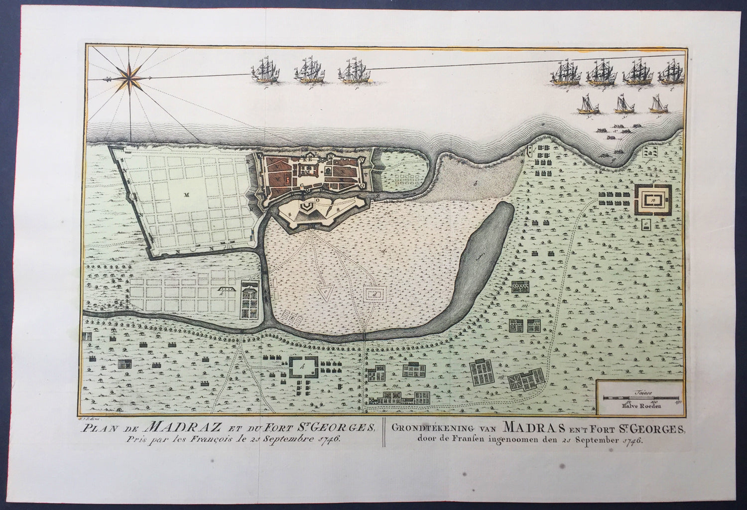
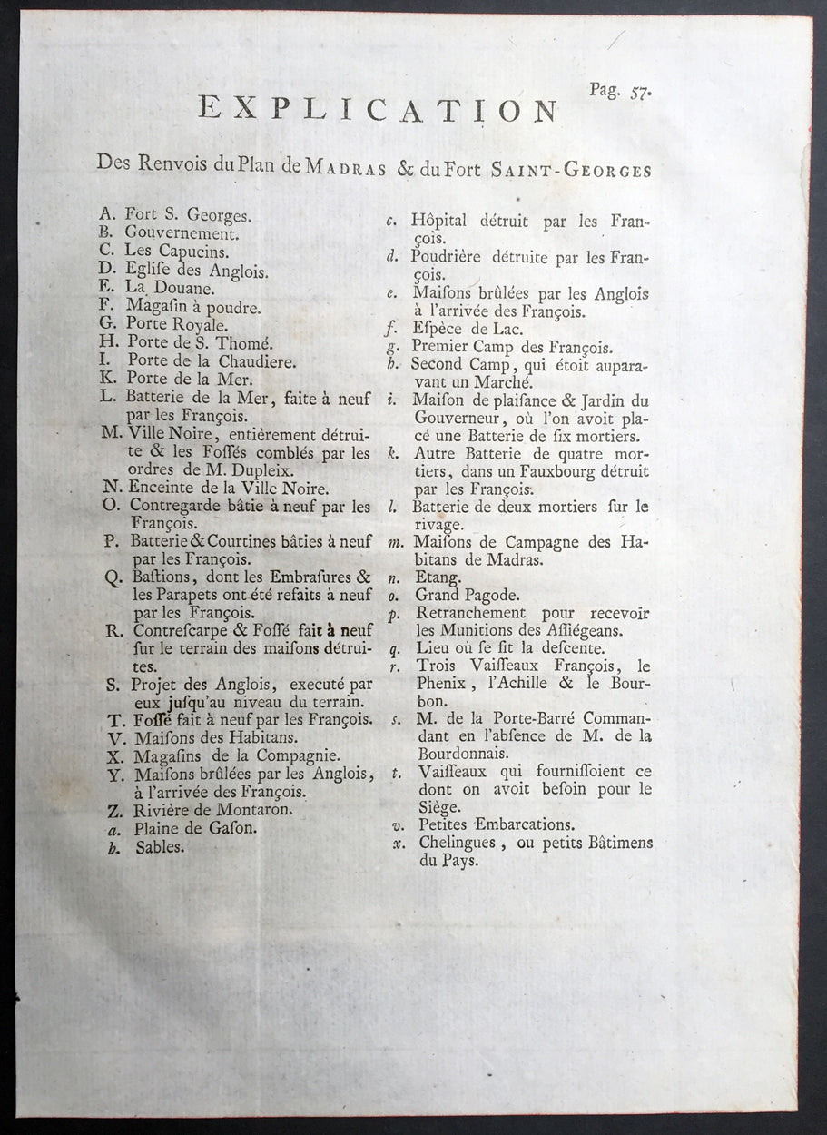
Description: This fine, original copper-plate engraved antique map a plan of the city of Chennai (Madras) the capital of Tamil Nadu, India and the old British Fort of St George (during the brief French occupation in 1746) - with separate Index of all the buildings and important places by Jakob van Schley in 1757 was published in Antoine François Prevosts 15 volumes of Histoire Generale des Voyageswritten by Prevost & other authors between 1746-1790.
Fort St George (or historically, White Town) is the name of the first English (later British) fortress in India, founded in 1644 at the coastal city of Madras, the modern city of Chennai. The construction of the fort provided the impetus for further settlements and trading activity, in what was originally an uninhabited land. Thus, it is a feasible contention to say that the city evolved around the fortress. The fort currently houses the Tamil Nadu legislative assembly and other official buildings. The East India Company (EIC), which had entered India around 1600 for trading activities, had begun licensed trading at Surat, which was its initial bastion. However, to secure its trade lines and commercial interests in the spice trade, it felt the necessity of a port closer to the Malaccan Straits, and succeeded in purchasing a piece of coastal land, originally called Chennirayarpattinam or Channapatnam, from aVijayanagar chieftain named Damerla Chennappa Nayaka based in Chandragiri, where the Company began the construction of a harbour and a fort. The fort was completed on 23 April 1644 at a cost of £3000, coinciding with St George's Day, celebrated in honour of the patron saint of England. The fort, hence christened Fort St George, faced the sea and some fishing villages, and it soon became the hub of merchant activity. It gave birth to a new settlement area called George Town (historically referred to as Black Town), which grew to envelop the villages and led to the formation of the city of Madras. It also helped to establishEnglish influence over the Carnatic and to keep the kings of Arcot and Srirangapatna, as well as the French forces based at Pondichéry, at bay. In 1665, after the EIC received word of the formation of the newFrench East India Company, the fort was strengthened and enlarged while its garrison was increased. According to the 17th century traveller Thomas Bowrey, Fort St. George was: "without all dispute a beneficiall place to the Honourable English India Company, and with all the Residence of theire Honourable Agent and Governour all of their Affaires Upon this Coast and the Coast of Gingalee, the Kingdoms also of Orixa, (Orissa) Bengala (Bengal), and Pattana (Patna), the said Governour and his Councell here resideigne, for the Honour of our English Nation keepinge and maintainneinge the place in great Splendour, Civil and good Government, Entertaineinge nobly all Foraign Embassadors, and provideinge great quantities of Muzlinge (Muslin) Callicoes (Calico) &c. to be yearly transported to England." The Fort is a stronghold with 6 metres (20 ft) high walls that withstood a number of assaults in the 18th century. It briefly passed into the possession of the French from 1746 to 1749, but was restored to Great Britain under the Treaty of Aix-la-Chapelle, which ended the War of the Austrian Succession.
General Description: Paper thickness and quality: - Heavy and stable Paper color: - off white Age of map color: - Original Colors used: - Yellow, green, red, brown. General color appearance: - Authentic and fresh Paper size: - 15in x 10in (380mm x 255mm) Plate size: - 12 1/2in x 8 1/2in (320mm x 215mm) Margins: - Min 1/2in (12 mm)
Imperfections: Margins: - None Plate area: - Folds as issued Verso: - None
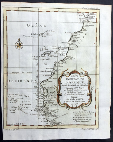
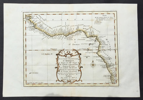
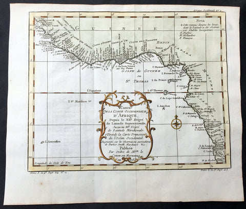
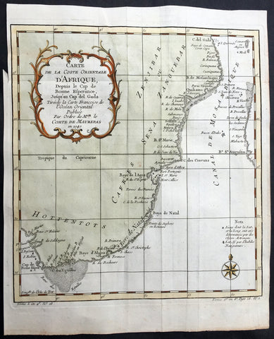
Background: One of Antoine Francois Prevosts monumental undertakings was his history of exploration & discovery in 15 volumes titledHistoire Générale des Voyages written between 1746-1759 and was extended to 20 volumes after his death by various authors.The 20 volumes cover the early explorations & discoveries on 3 continents: Africa (v. 1-5), Asia (v. 5-11), and America (v. 12-15) with material on the finding of the French, English, Dutch, and Portugese.A number of notable cartographers and engravers contributed to the copper plate maps and views to the 20 volumes including Nicolas Bellin, Jan Schley, Chedel, Franc Aveline, Fessard, and many others.The African volumes cover primarily coastal countries of West, Southern, and Eastern Africa, plus the Congo, Madagascar, Arabia and the Persian Gulf areas.The Asian volumes cover China, Korea, Tibet, Japan, Philippines, and countries bordering the Indian Ocean.Volume 11 includes Australia and Antarctica.Volumes 12-15 cover voyages and discoveries in America, including the East Indies, South, Central and North America.Volumes 16-20 include supplement volumes & tables along with continuation of voyages and discoveries in Russia, Northern Europe, America, Asia & Australia.Jakob van der Schley aka Jakob van Schley (1715 - 1779) was a Dutch draughtsman and engraver. He studied under Bernard Picart (1673-1733) whose style he subsequently copied. His main interests were engraving portraits and producing illustrations for \\\"La Vie de Marianne\\\" by Pierre Carlet de Chamblain de Marivaux (1688-1763) published in The Hague between 1735 and 1747.He also engraved the frontispieces for a 15-volume edition of the complete works of Pierre de Brantôme (1540-1614), \\\"Oeuvres du seigneur de Brantôme\\\", published in The Hague in 1740.He is also responsible for most of the plates in the Hague edition of Prévosts Histoire générale des voyages. (Ref: Tooley; M&B)