Welcome to Classical Images!
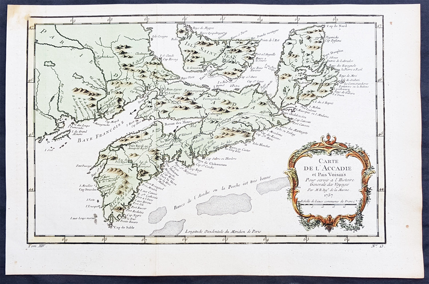
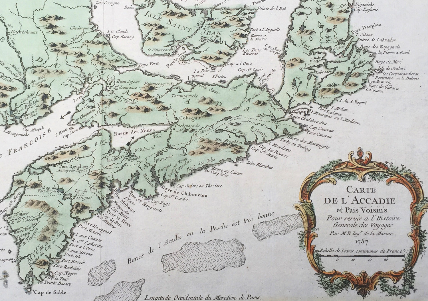
Description: This beautifully hand coloured originalantique map* of Arcadia, Nova Scotia, Canada by Jacques Nicolas Bellin was engraved in 1757 - the date is engraved in the title cartouche - and was published in the 1757 French edition of Antoine-François Prevosts 20 volume L`Histoire Generale des Voyages published by Pierre de Hondt in the Hague between 1747 & 1785.
Background : Acadia was a colony of New France in north-eastern North America that included parts of eastern Quebec, the Maritime provinces, and modern-day Maine to the Kennebec River. During much of the 17th and early 18th centuries, Norridgewock on the Kennebec River and Castine at the end of the Penobscot River were the southernmost settlements of Acadia. The actual specification by the French government for the territory refers to lands bordering the Atlantic coast, roughly between the 40th and 46th parallels. Later, the territory was divided into the British colonies which became Canadian provinces and American states. The population of Acadia included members of the Wabanaki Confederacy and descendants of emigrants from France (i.e., Acadians). The two communities intermarried, which resulted in a significant portion of the population of Acadia being Métis. The first capital of Acadia, established in 1605, was Port-Royal. A British force from Virginia attacked and burned down the town in 1613 but it was later rebuilt nearby, where it remained the longest serving capital of French Acadia until the British Siege of Port Royal in 1710. Over seventy-four years there were six colonial wars, in which English and later British interests tried to capture Acadia starting with King William's War in 1689. During these wars, along with some French troops from Quebec, some Acadians, the Wabanaki Confederacy, and French priests continuously raided New England settlements along the border in Maine. While Acadia was officially conquered in 1710 during Queen Anne's War, present-day New Brunswick and much of Maine remained contested territory. Present-day Prince Edward Island (Île Saint-Jean) and Cape Breton (Île Royale) as agreed under Article XIII of the Treaty of Utrecht remained under French control. By militarily defeating the Wabanaki Confederacy and the French priests, present-day Maine fell during Father Rale's War. During King George's War, France and New France made significant attempts to regain mainland Nova Scotia. After Father Le Loutre's War, present-day New Brunswick fell to the British. Finally, during the French and Indian War (the North American theatre of the Seven Years' War), both Île Royale and Île Saint-Jean fell to the British in 1758. Today, the term Acadia is used to refer to regions of North America that are historically associated with the lands, descendants, and/or culture of the former French region. It particularly refers to regions of The Maritimes with French roots, language, and culture, primarily in New Brunswick, Nova Scotia, the Magdalen Islands and Prince Edward Island, as well as in Maine It can also be used to refer to the Acadian diasporain southern Louisiana, a region also referred to as Acadiana. In the abstract, Acadia refers to the existence of a French culture in any of these regions. People living in Acadia, and sometimes former residents and their descendants, are called Acadians, also later known as Cajuns after resettlement in Louisiana.
Antoine François Prévost d'Exiles 1697 - 1763, usually known simply as the Abbé Prévost, was a French author and novelist. (Ref: Tooley; M&B)
General Description: Paper thickness and quality: - Heavy and stable Paper color: - off white Age of map color: - Original Colors used: - Yellow, green, red, brown. General color appearance: - Authentic and fresh Paper size: - 15in x 10in (380mm x 255mm) Plate size: - 13 1/2in x 9in (345mm x 230mm) Margins: - Min 1/2in (12mm)
Imperfections: Margins: - None Plate area: - Folds as issued Verso: - None