Vincenzo Maria Coronelli (1650-1718)
Profile :
Ordained as a Franciscan priest, Coronelli spent most of his life in Venice, becoming a noted theologian and being appointed, in 1699, Father General of his order. By that time he was already famous as a mathematician, cartographer and globe maker and his influence led to a revival of interest in these subjects in Italy at the end of the seventeenth century.
He was certainly the greatest cartographer of his time there and became Cosmographer to the Venetian Republic, taught geography in the University and, in 1680, founded the first geographical society, the 'Academia Cosmografica degli Argonauti' In his lifetime he compiled and engraved over 500 maps including a large 2-volume work, the Atlante Veneto, somewhat reminiscent of Robert Dudley's Dell' Arcano del Mare; he is equally well known for his construction of very large terrestrial and celestial globes even finer than those of Blaeu, including one, 15 feet in diameter, made for Louis XIV of France.
Vincenzo Maria Coronelli (8)
1691 Coronelli Large Antique Map of The Liege Region of Belgium - Maastricht
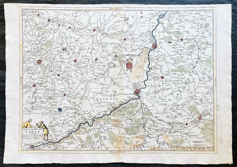
- Title : Vescovato di Leige
- Ref #: 16271
- Size: 27in x 19 1/2in (685mm x 495mm)
- Date : 1691
- Condition: (A+) Fine Condition
Description
This large, fine, scarce & beautifully hand coloured original antique map of the Liege Region of Belgium - centering on the Meusa River and the cities of Liege, Maastricht, Namur & Tienen - was published by Vincenzo Maria Coronelli (1650-1718) in 1691.
Coronelli was one of the finest engravers & cartographers of any era, producing some of the most stunning work ever seen. This is evident in this beautiful map. He was a master craftsman with an eye for detail. You can feel the uncompromising accuracy & passion in his work when you study his maps & globes. (Ref: Shirley; Tooley; M&B)
General Description:
Paper thickness and quality: - Heavy and stable
Paper color: - white
Age of map color: - Early
Colors used: - Green, yellow, pink, blue
General color appearance: - Authentic
Paper size: - 27in x 19 1/2in (685mm x 495mm)
Plate size: - 24 1/2in x 19in (620mm x 485mm)
Margins: - min. 1/2in (10mm)
Imperfections:
Margins: - None
Plate area: - Light age toning along centerfold
Verso: - 3 small repairs along centerfold
1692 Vincenzo Coronelli Antique Globe Gore Rare Map of Australia, Indonesia
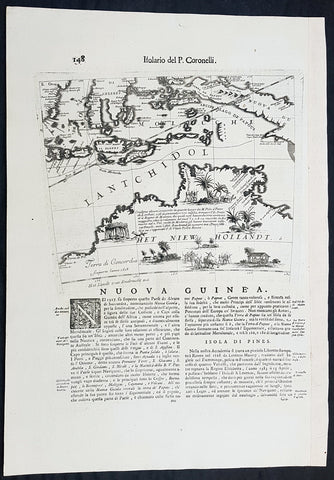
- Title : Nuova Guinea
- Size: 19 1/2in x 14in (495mm x 360mm)
- Condition: (A+) Fine Condition
- Date : 1692
- Ref #: 30783
Description:
This finely engraved original antique map, a scarce Globe Gore map section - from Vincenzo Coronellis original 42in Globe of Australia, New Guinea and parts of the Islands of Indonesia - one of the earliest detailed maps of Australia - was published by Vincenzo Maria Coronelli in the 1696 Venice edition of Isolario dell Atlante Veneto.
To my mind Coronellis maps are some of the most beautifully engraved maps of the 17th century and the epitome of these are his Globe Gores.
In 1696 Coronelli published all his globe gores - from the 2in to the 42 in Globes - in an atlas, Libero dei Globi, part of the great series of atlases, Isolario dell Atlante Veneto that was published by Coronelli to ensure his work was available to a wider audience, as very few could afford travel to Venice, Rome or Paris to view his completed globes.
General Definitions:
Paper thickness and quality: - Heavy and stable
Paper color : - off white
Age of map color: -
Colors used: -
General color appearance: -
Paper size: - 19 1/2in x 14in (495mm x 360mm)
Plate size: - 11 1/2in x 9 1/2in (280mm x 235mm)
Margins: - Min 1in (25mm)
Imperfections:
Margins: - None
Plate area: - None
Verso: - None
Background:
The original globe gores for the 42in Terrestrial & Celestial Globe were printed on 12 full length sheets - with two polar calottes - in 1688.
To help fit into Coronellis future publications of Atlante Veneto, Libro dei Globi and Isolario dell Atlante Veneto the gore sheets were re-issued as the same size but cut into smaller sections. This effectively allowed the gores to be published in their original size but instead of one sheet per gore there were 2, 4 or 6 sheets making up the one gore.
The first edition of Coronellis 3 ½-foot celestial globe was engraved by Nolin in Paris after drawings provided by the Italian geographer and was printed in 1688. At the same time, its terrestrial counterpart was engraved and printed in Venice under Coronellis direction. These globes were produced in part as replicas of the gigantic and unique 15 foot-diameter pair of globes that Coronelli constructed and presented to Louis XIV, the King of France, in 1683, and which secured his fame as Europes premier globe maker. In 1693, soon after Coronelli engraved and printed the first Venetian edition of the 3 ½-foot celestial globe, Nolin engraved at Paris an entirely new edition on new plates. This globe was based on Coronellis work, but with the main legends in Latin, not Italian, as befitted a French market. The 3 ½ foot celestial globe was one of the crowning glories of Coronellis output and was also the grandest celestial globe of the 17th century.
(Ref: Shirley; Armao, Ermanno. Vincenzo Coronelli Cenni sulluomo e la sua Vita Catalogo... Bibliopolis, Florence pp.130-134)
1692 Vincenzo Coronelli Large Original Antique Globe Gore Map of South America
-
Title : South America
- Ref #: 17007
-
Condition: (A+) Fine Condition
- Size: 19 1/2in x 12 1/4in (495mm x 310mm)
- Date : 1692
Description:
This large original antique copper plate engraved Globe Gore, a map of South America - from Vincenzo Coronellis original 42in Globe - was published by Vincenzo Maria Coronelli in the 1696 Venice edition of Isolario dell Atlante Veneto.
To my mind Coronellis maps are some of the most beautifully engraved maps of the 17th century and the epitome of these are his Globe Gores.
In 1696 Coronelli published all his globe gores - from the 2in to the 42 in Globes - in an atlas, Libero dei Globi, part of the great series of atlases, Isolario dell Atlante Veneto that was published by Coronelli to ensure his work was available to a wider audience, as very few could afford travel to Venice, Rome or Paris to view his completed globes.
General Definitions:
Paper thickness and quality: - Heavy and stable
Paper color : - off white
Age of map color: -
Colors used: -
General color appearance: -
Paper size: - 19 1/2in x 12 1/4in (495mm x 310mm)
Plate size: - 18in x 11in (455mm x 280mm)
Margins: - Min 1/2in (12mm)
Imperfections:
Margins: - None
Plate area: - None
Verso: - None
Background:
The original globe gores for the 42in Terrestrial & Celestial Globe were printed on 12 full length sheets - with two polar calottes - in 1688.
To help fit into Coronellis future publications of Atlante Veneto, Libro dei Globi and Isolario dell Atlante Veneto the gore sheets were re-issued as the same size but cut into smaller sections. This effectively allowed the gores to be published in their original size but instead of one sheet per gore there were 2, 4 or 6 sheets making up the one gore.
The first edition of Coronellis 3 ½-foot celestial globe was engraved by Nolin in Paris after drawings provided by the Italian geographer and was printed in 1688. At the same time, its terrestrial counterpart was engraved and printed in Venice under Coronellis direction. These globes were produced in part as replicas of the gigantic and unique 15 foot-diameter pair of globes that Coronelli constructed and presented to Louis XIV, the King of France, in 1683, and which secured his fame as Europes premier globe maker. In 1693, soon after Coronelli engraved and printed the first Venetian edition of the 3 ½-foot celestial globe, Nolin engraved at Paris an entirely new edition on new plates. This globe was based on Coronellis work, but with the main legends in Latin, not Italian, as befitted a French market. The 3 ½ foot celestial globe was one of the crowning glories of Coronellis output and was also the grandest celestial globe of the 17th century.
(Ref: Shirley; Armao, Ermanno. Vincenzo Coronelli Cenni sulluomo e la sua Vita Catalogo... Bibliopolis, Florence pp.130-134)
Please note all items auctioned are genuine, we do not sell reproductions. A Certificate of Authenticity (COA) can be issued on request.
1693 Coronelli Antique Globe Gore Part of Southern Pacific below New Zealand
- Title : Pacif
- Ref #: 31933
- Size: 11 1/2in x 10 1/2in (290mm x 270mm)
- Date : 1693
- Condition: (A+) Fine Condition
Description:
This finely engraved original hand coloured scarce approx. 1/4 sheet part Globe Gore map section - from Coronellis 42in Globe - of the very southern Pacific Ocean south of New Zealand centering on a finely engraved compass rose - was published by Vincenzo Maria Coronelli (1650 - 1718) in the 1693 Venice edition of Libro dei Globi.
(I have included a image below of the complete view of Coronellis Western Globe Gores so you can see where these gores fit the globe. The image below is an example only, from Rodney Shirleys "The Mapping of The World")
Background:
The original globe gores for the 42in Terrestial & Celestial Globes were printed on 12 full length sheets - with two polar calottes - in 1688.
To help fit into Coronellis future publications of Atlante Veneto, Libro dei Globi andIsolario dell' Atlante Veneto the gore sheets were re-issued as the same size but cut into smaller sections. This effectively allowed the gores to be published but instead of one sheet per gore there were cut into 2, 4 or 6 sections to make the one gore sheet.
The first edition of Coronelli's 3 ½-foot celestial globe was engraved by Nolin in Paris after drawings provided by the Italian geographer and was printed in 1688. At the same time, its terrestrial counterpart was engraved and printed in Venice under Coronelli's direction. These globes were produced in part as replicas of the gigantic and unique 15 foot-diameter pair of globes that Coronelli constructed and presented to Louis XIV, the King of France, in 1683, and which secured his fame as Europe's premier globe maker. In 1693, soon after Coronelli engraved and printed the first Venetian edition of the 3 ½-foot celestial globe, Nolin engraved at Paris an entirely new edition on new plates. This globe "was based on Coronelli's work, but with the main legends in Latin, not Italian, as befitted a French market. The 3 ½ foot celestial globe was one of the crowning glories of Coronelli's output and was also the grandest celestial globe of the 17th century. (Ref: Shirley; Armao, Ermanno. Vincenzo Coronelli Cenni sull'uomo e la sua Vita Catalogo... Bibliopolis, Florence, pp.130-134)
General Description:
Paper thickness and quality: - Heavy and stable
Paper color: - off white
Age of map color: - Early
Colors used: - Red, yellow, blue
General color appearance: - Authentic
Paper size: - 11 1/2in x 10 1/2in (290mm x 270mm)
Plate size: - 11 1/2in x 10 1/2in (290mm x 270mm)
Margins: - Min 1/2in (12mm)
Imperfections:
Margins: - None
Plate area: - Creasing along fold, small sew hole
Verso: - None
1693 Coronelli Antique Globe Gores x 2 of The Caribbean, Central & South America
- Title : Golfo Del Mexico; L Archipelago Del Mexico
- Date : 1693
- Condition: (A) Very Good Condition
- Ref: 31923/31925
- Size: 32 1/4in x 16in (820mm x 405mm)
Description:
This is a rare opportunity to acquire two original antique cropped Globe Gores of the The Caribbean, Central & Northern South America, from Florida to The West Indies and Venezuela - that were published by Vincenzo Maria Coronelli (1650 - 1718) in the 1693 Venice edition of Atlante Veneto, Libro dei Globi.The Gores are printed on heavy clean cabled paper and are cropped sections of the half gores. I can only imagine that they were cropped and sections cut in the past construction of the Coronelli Globes, acquired by us in a large collection some years ago.
In 1693 Coronelli published all his gores - from the 2in to the 42 in - in an atlas, Libero dei Globi, part of the great series of atlases, Atlante Veneto. Libero dei Globi was published by Coronelli to ensure his work was available to a wider audience, as very few could afford travel to Venice, Rome or Paris to view his completed globes.
Background: In the early 1680’s Vincenzo Coronelli constructed two vast 15ft diameter terrestrial & celestial globes for Louis XIV of France. These were meticulously hand drawn & engraved. Such was the admiration of these Globes that in 1688 Coronelli began the engraving & publication of Globe Gores for the construction of two 110cm (42in) terrestrial & celestial globes.
Coronellis claim to have produced the best globes of any age was exemplified by the high demand and purchase of the globes by various institutions & cities within Europe. Yet many scholars still did not have the opportunity to visit Paris, London, Rome or Venice to view them and so Coronelli devised his famous atlas Libero dei Globi the first atlas of globe gores ever produced. TheLibro formed part of a great series of atlases by Coronelli, the Atlante Veneto,in which Coronelli was able to combine the two cartographic art forms in which he excelled, maps & globes.
The engraving of the gores was of the highest standard with neat contrasting lettering and five large cartouches of a singular grace and elegance. One cartouche situated below Australia carries a portrait of the author and Pope Alexander VI.
Some of the more interesting features contained within the Gores are the recording of recent French explorations in North America, such as La Salles journey to the mouth of the Mississippi in 1681-87 & the French possessions within North America. Elsewhere the Caspian Sea is drawn closer to its modern shape, the Nile in Africa is shown without its fictitious source and the Blue Nile is shown correctly from a large lake in Ethiopia. The tracks of Le Maire crossing of the Pacific in 1616 are marked, as is the voyage of Chaumont to Siam in 1685-6. There are an unusual number of legends, all explanatory and informative along with many vignettes of ships and fishing scenes throughout the globe.
Coronelli was one of the finest engravers & cartographers of any era, producing some of the most stunning work ever seen. These Globe Gores are no exception. Coronelli was a master craftsman with an eye for detail. You can feel the uncompromising accuracy & passion in his work when you study his maps & globes.
These globe gores are scarce, with only a few sales records from the last 25 years. Similarly there is very little choice currently on the market. This scarcity ensures ongoing value and future appreciation. (Ref: Shirley 538; Tooley; Dr. Helen Wallis The Map Collector Dec 1980;Armao, Ermanno. Vincenzo Coronelli Cenni sull'uomo e la sua Vita Catalogo... Bibliopolis, Florence pp.130-134)
General Description:
Paper thickness and quality: - Heavy and stable
Paper color: - white
Age of map color: - Later
Colors used: - Yellow, green, pink, blue
General color appearance: - Fresh & original
Paper size: - 12in x 11 1/2in (310mm x 290mm)ea
Margins: - min. 1/2in (10mm)
Imperfections:
Margins: - Left margin of left gore extended
Plate area: - 3 small sew holes in right gore, left gore cut into left section of image
Verso: - None
1693 Coronelli Antique Map Globe Gore Section of India, Pakistan, Saudi Arabia
- Title : Parton Da Goa Per Andare al Capo
- Ref #: 31943
- Size: 11 1/2in x 11 1/2in (295mm x 295mm)
- Date : 1693
- Condition: (A) Very Good Condition
Description:
This fine, beautifully hand coloured original antique map - a section of a Globe Gore - of India, Saudi Arabia, the Persian Gulf & Pakistan was published by Vincenzo Maria Coronelli (1650 - 1718) in the 1693 Venice edition of Atlante Veneto, Libro dei Globi.
The Gore is printed on heavy, clean cabled paper late 17th century paper.
The original copper-plates for these gores were engraved in 1688 by Coronelli for the construction of his large 42in (110cm) terrestrial globe.
In 1693 Coronelli published all his gores - from the 2in to the 42 in - in an atlas, Libero dei Globi, part of the great series of atlases, Atlante Veneto. Libero dei Globi was published by Coronelli to ensure his work was available to a wider audience, as very few could afford travel to Venice, Rome or Paris to view his completed globes.
Background: In the early 1680’s Vincenzo Coronelli constructed two vast 15ft diameter terrestrial & celestial globes for Louis XIV of France. These were meticulously hand drawn & engraved. Such was the admiration of these Globes that in 1688 Coronelli began the engraving & publication of Globe Gores for the construction of two 110cm (42in) terrestrial & celestial globes.
Coronellis claim to have produced the best globes of any age was exemplified by the high demand and purchase of the globes by various institutions & cities within Europe. Yet many scholars still did not have the opportunity to visit Paris, London, Rome or Venice to view them and so Coronelli devised his famous atlas Libero dei Globi the first atlas of globe gores ever produced. The Libro formed part of a great series of atlases by Coronelli, the Atlante Veneto, in which Coronelli was able to combine the two cartographic art forms in which he excelled, maps & globes.
The engraving of the gores was of the highest standard with neat contrasting lettering and five large cartouches of a singular grace and elegance. One cartouche situated below Australia carries a portrait of the author and Pope Alexander VI.
Some of the more interesting features contained within the Gores are the recording of recent French explorations in North America, such as La Salles journey to the mouth of the Mississippi in 1681-87 & the French possessions within North America. Elsewhere the Caspian Sea is drawn closer to its modern shape, the Nile in Africa is shown without its fictitious source and the Blue Nile is shown correctly from a large lake in Ethiopia. The tracks of Le Maire crossing of the Pacific in 1616 are marked, as is the voyage of Chaumont to Siam in 1685-6. There are an unusual number of legends, all explanatory and informative along with many vignettes of ships and fishing scenes throughout the globe.
Coronelli was one of the finest engravers & cartographers of any era, producing some of the most stunning work ever seen. These Globe Gores are no exception. Coronelli was a master craftsman with an eye for detail. You can feel the uncompromising accuracy & passion in his work when you study his maps & globes.
These globe gores are scarce, with only a few sales records from the last 25 years. Similarly there is very little choice currently on the market. This scarcity ensures ongoing value and future appreciation. (Ref: Shirley 538; Tooley; Dr. Helen Wallis The Map Collector Dec 1980;Armao, Ermanno. Vincenzo Coronelli Cenni sull'uomo e la sua Vita Catalogo... Bibliopolis, Florence pp.130-134)
General Description:
Paper thickness and quality: - Heavy and stable
Paper color: - white
Age of map color: - Later
Colors used: - Yellow, green, pink
General color appearance: - Fresh
Paper size: - 11 1/2in x 11 1/2in (295mm x 295mm)
Margins: - min. 1/2in (10mm)
Imperfections:
Margins: - Margins cropped past plate-mark
Plate area: - Vertical crease, small binding holes
Verso: - Vertical crease, small binding holes
1696 Coronelli Antique Map Globe Gore Section of SE Africa & Madagascar
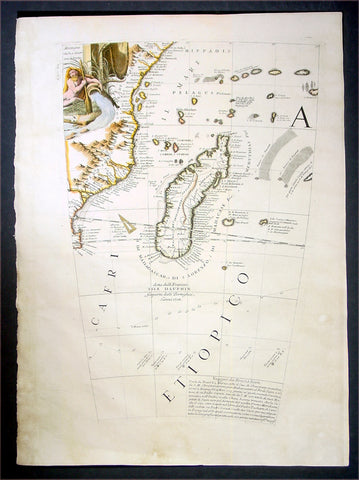
- Title : Cafri Etiopico
- Date : 1696
- Condition: (A+) Fine Condition
- Ref: 30781
- Size: 19 1/2in x 14in (495mm x 355mm)
Description:
This is a rare opportunity to acquire one of the hand coloured original antique Globe Gores of Madagascar & SE Africa by Vincenzo Coronelli published in 1696.
The copper-plates for these gores were originally engraved in 1688 by Coronelli for the construction of the large 42in (110cm) terrestrial globe.
In 1696 Coronelli published all his gores - from the 2in to the 42 in - in an atlas, Libero dei Globi, part of the great series of atlases,Atlante Veneto. Libero dei Globi was published by Coronelli to ensure his work was available to a wider audience, as very few could afford travel to Venice, Rome or Paris to view his completed globes.
Background:
In the early 1680’s Vincenzo Coronelli constructed two vast 15ft diameter terrestrial & celestial globes for Louis XIV of France. These were meticulously hand drawn & engraved. Such was the admiration of these Globes that in 1688 Coronelli began the engraving & publication of Globe Gores for the construction of two 110cm (42in) terrestrial & celestial globes.
Coronellis claim to have produced the best globes of any age was exemplified by the high demand and purchase of the globes by various institutions & cities within Europe. Yet many scholars still did not have the opportunity to visit Paris, London, Rome or Venice to view them and so Coronelli devised his famous atlas Libero dei Globi the first atlas of globe gores ever produced. The Libroformed part of a great series of atlases by Coronelli, the Atlante Veneto, in which Coronelli was able to combine the two cartographic art forms in which he excelled, maps & globes.
The engraving of the gores was of the highest standard with neat contrasting lettering and five large cartouches of a singular grace and elegance. One cartouche situated below Australia carries a portrait of the author and Pope Alexander VI.
Some of the more interesting features contained within the Gores are the recording of recent French explorations in North America, such as La Salles journey to the mouth of the Mississippi in 1681-87 & the French possessions within North America. Elsewhere the Caspian Sea is drawn closer to its modern shape, the Nile in Africa is shown without its fictitious source and the Blue Nile is shown correctly from a large lake in Ethiopia. The tracks of Le Maire crossing of the Pacific in 1616 are marked, as is the voyage of Chaumont to Siam in 1685-6. There are an unusual number of legends, all explanatory and informative along with many vignettes of ships and fishing scenes throughout the globe.
Coronelli was one of the finest engravers & cartographers of any era, producing some of the most stunning work ever seen. These Globe Gores are no exception. Coronelli was a master craftsman with an eye for detail. You can feel the uncompromising accuracy & passion in his work when you study his maps & globes.
These globe gores are scarce, with only a few sales records from the last 25 years. Similarly there is very little choice currently on the market. This scarcity ensures ongoing value and future appreciation. (Ref: Shirley 538; Tooley; Dr. Helen Wallis The Map Collector Dec 1980;Armao, Ermanno. Vincenzo Coronelli Cenni sull'uomo e la sua Vita Catalogo... Bibliopolis, Florence pp.130-134)
General Description:
Paper thickness and quality: - Heavy and stable
Paper color: - white
Age of map color: - Early
Colors used: - Yellow, green, blue
General color appearance: - Authentic
Paper size: - 19 1/2in x 14in (495mm x 355mm)
Plate size: - 19in x 11 1/2in (485mm x 290mm)
Margins: - min. 1/2in (12mm)
Imperfections:
Margins: - Light age toning
Plate area: - None
Verso: - None
1696 Coronelli Antique Map, Globe Gore, of India, Pakistan, Iran, Persian Gulf
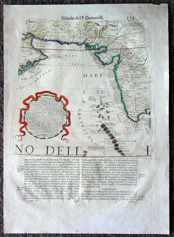
- Title : Isolario del P. Coronelli
- Date : 1696
- Condition: (A+) Fine Condition
- Ref: 42007
- Size: 19 1/2in x 14in (495mm x 355mm)
Description:
This is a rare opportunity to acquire an original antique Globe Gore of India and parts of the Middle East& Persia by Vincenzo Coronelli published in his 1696 edition ofIsolario dell' Atlante Veneto.
The copper-plates for these gores were originally engraved by Coronelli for the construction of the large 42in (110cm) terrestrial globe.
Coronelli published 2 different globe gore atlases, the 1693 edition of Libero dei Globiand the 1696 edition of Isolario dell' Atlante Veneto. The difference being the inclusion of Latin text to the latter publication.
Background:
In the early 1680’s Vincenzo Coronelli constructed two vast 15ft diameter terrestrial & celestial globes for Louis XIV of France. These were meticulously hand drawn & engraved. Such was the admiration of these Globes that in 1688 Coronelli began the engraving & publication of Globe Gores for the construction of two 110cm (42in) terrestrial & celestial globes.
Coronellis claim to have produced the best globes of any age was exemplified by the high demand and purchase of the globes by various institutions & cities within Europe. Yet many scholars still did not have the opportunity to visit Paris, London, Rome or Venice to view them and so Coronelli devised his famous atlas Libero dei Globi the first atlas of globe gores ever produced. The Libroformed part of a great series of atlases by Coronelli, the Atlante Veneto, in which Coronelli was able to combine the two cartographic art forms in which he excelled, maps & globes.
The engraving of the gores was of the highest standard with neat contrasting lettering and five large cartouches of a singular grace and elegance. One cartouche situated below Australia carries a portrait of the author and Pope Alexander VI.
Some of the more interesting features contained within the Gores are the recording of recent French explorations in North America, such as La Salles journey to the mouth of the Mississippi in 1681-87 & the French possessions within North America. Elsewhere the Caspian Sea is drawn closer to its modern shape, the Nile in Africa is shown without its fictitious source and the Blue Nile is shown correctly from a large lake in Ethiopia. The tracks of Le Maire crossing of the Pacific in 1616 are marked, as is the voyage of Chaumont to Siam in 1685-6. There are an unusual number of legends, all explanatory and informative along with many vignettes of ships and fishing scenes throughout the globe.
Coronelli was one of the finest engravers & cartographers of any era, producing some of the most stunning work ever seen. These Globe Gores are no exception. Coronelli was a master craftsman with an eye for detail. You can feel the uncompromising accuracy & passion in his work when you study his maps & globes.
These globe gores are scarce, with only a few sales records from the last 25 years. Similarly there is very little choice currently on the market. This scarcity ensures ongoing value and future appreciation. (Ref: Shirley 538; Tooley; Dr. Helen Wallis The Map Collector Dec 1980;Armao, Ermanno. Vincenzo Coronelli Cenni sull'uomo e la sua Vita Catalogo... Bibliopolis, Florence pp.130-134)
General Description:
Paper thickness and quality: - Heavy and stable
Paper color: - white
Age of map color: - Early
Colors used: - Green, yellow, pink, red
General color appearance: - Fresh
Paper size: - 19 1/2in x 14in (495mm x 355mm)
Plate size: - 11 1/2in x 11in (295mm x 280mm)
Margins: - min. 1/2in (12mm)
Imperfections:
Margins: - None
Plate area: - None
Verso: - None