Pacific Railroad Surveys
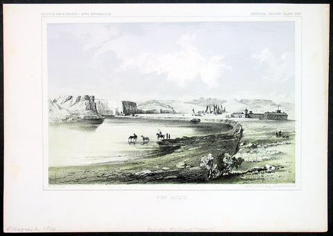
1855 USPRR Antique Print Fort Benton, Missouri River, Chouteau County, Montana
- Title : Fort Benton
- Ref : 81091
- Size: 11in x 9in (280mm x 230mm)
- Date : 1855
- Condition: (A+) Fine Condition
Description:
This original antique lithograph print of Fort Benton, on the Upper Missouri River Chouteau County, Montana by Sarony, Major & Knapp of New York was published for the United States Pacific Rail Road Expedition Survey (USPRR)northern survey expedition - between 1853-55.
General Definitions:
Paper thickness and quality: - Heavy and stable
Paper color : - off white
Age of map color: - Original
Colors used: - Yellow, green, blue, pink
General color appearance: - Authentic
Paper size: - 11in x 9in (280mm x 230mm)
Plate size: - 11in x 9in (280mm x 230mm)
Margins: - Min 1/2in (12mm)
Imperfections:
Margins: - Light age toning in margins
Plate area: - None
Verso: - None
Background:
Fort Benton is a city in and the county seat of Chouteau County, Montana, United States. Established in 1846, a full generation before the U.S. Civil War, Fort Benton is one of the oldest settlements in the American West; in contrast, many other places—including large cities today—were settled in the late 1860s, 1870s, or 1880s.
Established by Auguste Chouteau and Pierre Chouteau, Jr. of St. Louis in 1846 as the last fur trading post on the Upper Missouri River, the fort became an important economic center. For 30 years, the port attracted steamboats carrying goods, merchants, gold miners and settlers, coming from New Orleans, Memphis, St. Louis, Hannibal, Bismarck, Kansas City, etc. As the terminus for the 642-mile-long Mullan Road, completed by the US Army in 1860, and at the head of navigation of the Missouri River, Fort Benton was part of the overland link between trade on the Missouri and the Columbia River, at Fort Walla Walla, Washington. Twenty thousand migrants used the road in the first year to travel to the Northwest. It became an important route for miners from both directions going into the interior of Idaho, and north to Canada. Steamboat travel to Fort Benton from St. Louis, Missouri helped broadly fuel the development of the American West between 1860 and 1890, when it was supplanted by railroad transport. The river was an important route for miners to the newly discovered gold fields of southern Montana at what became Bannack and Virginia City beginning in 1862, and Helena, beginning in 1865.
With the decline of the fur trade, the American Fur Company sold the fort to the US Army in 1865, which named it for Senator Thomas Hart Benton of Missouri. A town had grown up around it that surpassed the military presence. Besides being one of the most important ports on the Missouri-Mississippi river system, Fort Benton was once the World\'s Innermost Port. Its importance in trade was superseded by the construction of transcontinental railroads in the late 19th century. In 1867 Fort Benton was the site where Union General Thomas Francis Meagher, then acting governor of Montana Territory, fell overboard from his steamboat and drowned in the river; his body was never recovered.
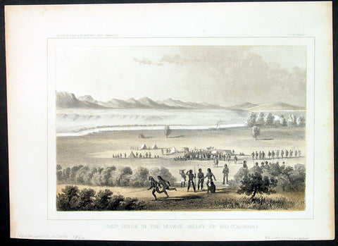
1855 USPRR Antique Print of the Mohave Indians, Mojave Desert, Colorado River
- Title : Camp scene in the Mojave Valley of Rio Colorado
- Ref : 81091-1
- Size: 11in x 9in (280mm x 230mm)
- Date : 1855
- Condition: (A+) Fine Condition
Description:
This original antique lithograph print of American Mohave Indians in the Mojave Desert camp - next to the Colorado River - in southern Nevada, Arizona by Sarony, Major & Knapp of New York was published for the United States Pacific Rail Road Expedition Survey (USPRR)northern survey expedition - between 1853-55.
General Definitions:
Paper thickness and quality: - Heavy and stable
Paper color : - off white
Age of map color: - Original
Colors used: - Yellow, green, blue, pink
General color appearance: - Authentic
Paper size: - 11in x 9in (280mm x 230mm)
Plate size: - 11in x 9in (280mm x 230mm)
Margins: - Min 1/2in (12mm)
Imperfections:
Margins: - Light age toning in margins
Plate area: - None
Verso: - None
Background:
Mohave or Mojave are a Native American people indigenous to the Colorado River in the Mojave Desert. The Fort Mojave Indian Reservation includes territory within the borders of California, Arizona, and Nevada. The Colorado River Indian Reservation includes parts of California and Arizona and is shared by members of the Chemehuevi, Hopi, and Navajo peoples.
The original Colorado River and Fort Mojave reservations were established in 1865 and 1870, respectively. Both reservations include substantial senior water rights in the Colorado River; water is drawn for use in irrigated farming.
The four combined tribes sharing the Colorado River Indian Reservation function today as one geo-political unit known as the federally recognized Colorado River Indian Tribes; each tribe also continues to maintain and observe its individual traditions, distinct religions, and culturally unique identities.
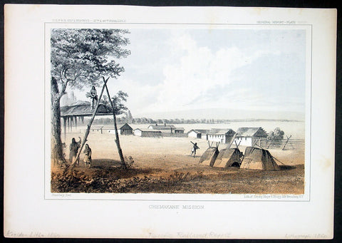
1855 USPRR Large Antique Print Tshimakain Indian Mission, Ford, Washington State
- Title : Chemakane Mission
- Ref : 81089
- Size: 11in x 9in (280mm x 230mm)
- Date : 1855
- Condition: (A+) Fine Condition
Description:
This original antique lithograph print of the Chemakane or Tshimakain Native American Mission, located northwest of Spokane (near the town of Ford) in eastern Washington State by Sarony, Major & Knapp of New York was published for the United States Pacific Rail Road Expedition Survey (USPRR) northern survey expedition - between 1853-55.
General Definitions:
Paper thickness and quality: - Heavy and stable
Paper color : - off white
Age of map color: - Original
Colors used: - Yellow, green, blue, pink
General color appearance: - Authentic
Paper size: - 11in x 9in (280mm x 230mm)
Plate size: - 11in x 9in (280mm x 230mm)
Margins: - Min 1/2in (12mm)
Imperfections:
Margins: - Light age toning in margins
Plate area: - None
Verso: - None
Background:
The Tshimakain Mission started on August 29, 1838, with the arrival of Presbyterian missionaries Cushing and Myra Fairbanks Eells and Elkanah and Mary Richardson Walker to the area along Chamokane Creek at the community of Ford, Washington. Fort Colvile Chief Factor Archibald McDonald recommended the area to Eells and Walker on their first visit to the area.
On April 23, 1838 after traveling to Independence, Missouri, the Eells, Walkers, William Henry and Mary Augusta Gray, Asa B. and Sarah Smith, and Andrew Rodgers, departed for the Oregon County with a Hudson Bay Company fur trader caravan to the Rendezvous. They arrived at Waiilatpu and the Whitman Mission on August 29, 1838.
For the next nine years under the auspices of American Board of Commissioners for Foreign Missions, the Tshimakain missionaries lived with the Spokane people.
On September 16, 1838, Eells conducted the first Protestant service in Stevens County at Chewelah.
In the fall of 1839, the missionaries started a school for the local Indians with 30 students rising to 80 over the winter.
On January 11, 1840, Eells house burned. Local Indians responded quickly to assist. When the Fort Colvile leader Archibald McDonald heard about the fire, he dispatched four men to make the house habitable.
In 1842, Elkanah Walker, with support from Cushing Eells, printed the Spokane Primer, a Salish language primer. This was the first book written in Washington.
The winter of 1846-47 was the most severe in the memory of the oldest Indians. It triggered the loss of many domestic animals for Indians and missionaries.
On November 29, 1847, Cayuse Indians massacred the members of the Whitman Mission in Walla Walla. Cushing Eells and Elkanah Walker were supposed to be at the Whitman Mission during the time of the massacre, but Elkanah Walker took ill, and Cushing Eells did not want to leave the families without support. As members of the Oregon Volunteers chased the Indians, it brought them closer to the Tshimakain Mission. One of the Indians involved in the massacre had family at Fool\'s Prairie, now Chewelah, to the north of the Tshimakain Mission. The Chief Factor John Lee Lewes of Hudson Bay Company Fort Colvile offered to house the missionaries up at the fort for their safety. At first they delayed going to the fort as the Spokane People wanted them there and would provide support. As the chase of the Cayuse Indians involved in the massacre stretched out, they finally sought the safety of the fort.
Colonel Henry A. G. Lee, Oregon Volunteers called for volunteers to bring the Tshimakain missionaries to the Willamette Valley and safety. Major Joseph Magone with 60 volunteers escorted the Eells and Walker families to Oregon City on June 22, 1848.
In July 1874, Eells came back to the area, the only one of the four missionaries to do so. The following Sunday, Eells conducted two services for the natives and two more for the white settlers at Chewelah. Eells consulted with John A. Simms, Indian agent for the area and located at Chewelah.
In 1892, a church was erected at Chewelah, although Eells was living west of the Cascade Mountains, he came and offered prayer in the new church some 54-years to the day after he first camped on the site. He gifted a bell for this church. He bought it in New York and paid for it a few days before his death.
During their time with the Spokane People teaching their faith, they never had a convert to their faith. But, in the spring of 1873, Spokane Garry invited the Reverend Henry Spalding to visit the area and baptize his people. Spalding baptized 253 adults and 81 children that summer.Rigobert Bonne
Pacific Railroad Surveys (1853-1855)
By the middle of the 19th century, the United States spanned the entire width of the North American continent from Atlantic to Pacific, but the only ways to get from one coast to the other were by ship or by arduous horse or wagon travel through deserts and mountains. The discovery of gold in California further stimulated westward traffic and only heightened the need for a faster and more convenient way to bring the far-flung parts of the country together.
In 1853 Congress commissioned the Army\\\'s Topographic Bureau to conduct a series of surveys to find a suitable route for a transcontinental railroad. There were six major expeditions; five of them covered the area between the Great Plains and California, Oregon, and Washington, and the sixth explored the coastal states of California and Oregon. All of these expeditions were accompanied by naturalists and were provided, through the Smithsonian, with equipment and instructions for collecting.
The northern survey, commanded by Isaac I. Stevens, governor of Washington Territory, explored roughly along the 47th parallel between St. Paul, MN and Puget Sound on the Pacific coast. J.G. Cooper, G. Gibbs, and George Suckley served as naturalists.
Another expedition, under the command of Capt. J. W. Gunnison, surveyed a central route along the 38th, 39th, and 41st parallels, through what is now Kansas, Colorado, Utah, and Nevada. On 26 October 1853, Gunnison and a party of his men, including the botanist F. Kreutzfeldt, were killed in a skirmish with Indians. Lt. E. G. Beckwith took over command and completed the expedition.
The third expedition, under the command of Lt. A. W. Whipple, followed the 35th parallel from Fort Smith, AR to the Mojave Desert in southern California. Naturalists included J.M. Bigelow, J. Marcou, and Caleb Kennerly.
The southern route followed the 32nd parallel and was covered by two expeditions: one under J. Pope went from the Red River to the Rio Grande, and the other, under Lt. J. G. Parke, worked between the Rio Grande and the Colorado River. Although the Pope expedition had no one formally assigned as a naturalist, collections were made by expedition personnel. Parke\\\'s expedition was accompanied by the naturalist A.L. Heerman, who later assisted R.S. Williamson, whose party explored a connecting route between 35th and 32nd parallels.
Another expedition under the command of R.S. Williamson and H.L. Abbott surveyed the area between the Sacramento Valley in California and the Columbia River, Oregon. Natural history collections were made by John S. Newberry and William P. Trowbridge. The route that was finally selected for the railroad largely followed the 38th parallel, but the decision was mainly political.
From a scientific viewpoint, the Railroad expeditions were a monumental accomplishment. Not only had the new western territories been explored and mapped, but the geology and biology were sampled more extensively than by previous expeditions. The success was due largely to the Smithsonian and Spencer Baird, which had supplied the equipment and instructions used by the collectors, and which had received the material when the expeditions returned from the field. These specimens formed a major part of the Smithsonian\\\'s growing collections and formed the basis for the description of many new species. In terms of ichthyological collections, Stevens\\\'s Expedition, with Drs. J.G.Cooper and George Suckley as surgeons and naturalists; Whipple\\\'s expedition, with Caleb Kennerly as physician and naturalist; and Williamson\\\'s Expedition, with Dr. A.L. Heerman as physician and naturalist, were particularly noteworthy. Reports on fishes collected during the Pacific Railroad Surveys, written mainly by Charles Girard, are found mostly in volume 10 of Reports of Explorations and Surveys, to ascertain the most practicable and economical route for a railroad from the Mississippi River to the Pacific Ocean, issued in 12 volumes by the War Department (1855-1860)