Mount and Page
1756 Mount & Page Large Maritime Map of Oslofjord - Oslo to Fredrikstad Norway
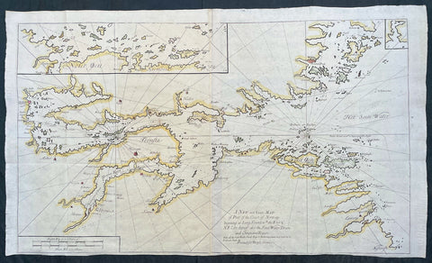
- Title : A New and Exact Map of Part of the Coast of Norway beginning at Long Sound wth. the East & N E Coast thereof; also the Soen Water Dram and Christiana Rivers ..., printed for Benyan Crowe
- Ref #: 17033
- Size: 41 1/2in x 24 1/4in (1.045m x 615mm)
- Date : 1756
- Condition: (A+) Fine Condition
Description:
This very large original hand coloured copper-plate engraved antique Maritime map or chart of the Oslofjord body of water stretching from Oslo to Fredrikstad, Norway was published in by Mount and Page in the 1756 edition of The English pilot : Describing the sea-coasts, capes, headlands, soundings, sands, shoals, rocks and dangers : the bays, roads, harbours, rivers and ports in the whole northern navigation.... Specifically from the Second Part of the Atlas series on Northern Navigation containing 31 large folding maps engraved by Francis Lamb and Herman Moll.
General Definitions:
Paper thickness and quality: - Heavy and stable
Paper color : - off white
Age of map color: - Original
Colors used: - Yellow, green, blue, pink
General color appearance: - Authentic
Paper size: - 41 1/2in x 24 1/4in (1.045m x 615mm)
Plate size: - 35in x 23 1/4in (990mm x 590mm)
Margins: - Min 1/4in (5mm)
Imperfections:
Margins: - Bottom margin cropped to plate-mark
Plate area: - Folds as issued
Verso: - Folds as issued
Background:
The English Pilot 1698 - 1803, was the first major sea-atlas produced in England and in its final form it consisted of five separate books, with the Fourth Book the first wholly English sea-atlas of American waters. Although the idea of the atlases originated with John Seller, he was involved in producing only the first two books. William Fisher and John Thornton produced The Fourth Book in 1689, and their successors Mount and Page continued to print it for over 100 years … Sellers proposal for a Sea Waggoner resulted in the production of The English Pilot, which consisted of five separate volumes with a common generic title. Book One included the southern navigation and Book Two the northern. Book Three was concerned with the Orient, Book Four with America, and Book Five contained Africa. Each book or volume has its own independent publishing history and appeared in numerous editions. The five separate books constitute a set only by virtue of the general title, and under that title The English Pilot is the first great sea-atlas produced in England. Of the five books, the fourth has the longest publication history and is the best known.
Mount & Page 1701 - 1790
Mount & Page was a firm of religious and maritime publishers that flourished in the eighteenth century. The name became well-known worldwide as an imprint of nautical charts.
The firm was founded in 1701 by Richard Mount (1654–1722) and Thomas Page (active 1700-1733). Mount had previously been in partnership with his father-in-law William Fisher (1631–1692) and inherited the business on the latter's death. As Mount & Page the firm flourished throughout the 18th century and made the fortunes of both families, helped by government contracts. Successive generations of Mounts and Pages worked in the business, and the families intermarried. One of its staple titles was Navigatio Britannica by John Barrow, published in 1750 and still being advertised in 1787.
By the 1760s, Richard Mount's grandson John Mount (1725–1786) was able to retire to Berkshire where he built Wasing Place. John's son William (1753–1815) was the last to work in the business, and later generations went into politics.