Mondhare & Jean
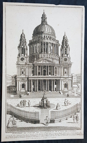
1770 Louis-Joseph Mondhare Antique Print View of St Pauls Cathedral, London England
- Title : Elevation Du Portail De La Cathedrale De St Paul De Londre
- Ref #: 93461
- Size: 14 1/2in x 9in (365mm x 245mm)
- Date : 1770
- Condition: (A+) Fine Condition
Description:
This original copper plate engraved antique print of St Pauls Cathedral, London was engraved and published by Louis-Joseph Mondhare in Paris in 1770
General Definitions:
Paper thickness and quality: - Heavy and stable
Paper color : - off white
Age of map color: -
Colors used: -
General color appearance: -
Paper size: - 14 1/2in x 9in (365mm x 245mm)
Plate size: - 14 1/2in x 9in (365mm x 245mm)
Margins: - Min 1/8in (5mm)
Imperfections:
Margins: - Margins cropped to plate mark
Plate area: - None
Verso: - None
Imperfections:
Margins: - None
Plate area: - None
Verso: - None
Background:
The task of designing a replacement structure was officially assigned to Sir Christopher Wren on 30 July 1669. He had previously been put in charge of the rebuilding of churches to replace those lost in the Great Fire. More than 50 City churches are attributable to Wren. Concurrent with designing St Pauls, Wren was engaged in the production of his five Tracts on Architecture.
Wren had begun advising on the repair of the Old St Pauls in 1661, five years before the fire in 1666. The proposed work included renovations to interior and exterior to complement the classical facade designed by Inigo Jones in 1630. Wren planned to replace the dilapidated tower with a dome, using the existing structure as a scaffold. He produced a drawing of the proposed dome which shows his idea that it should span nave and aisles at the crossing. After the Fire, it was at first thought possible to retain a substantial part of the old cathedral, but ultimately the entire structure was demolished in the early 1670s.
In July 1668 Dean William Sancroft wrote to Wren that he was charged by the Archbishop of Canterbury, in agreement with the Bishops of London and Oxford, to design a new cathedral that was Handsome and noble to all the ends of it and to the reputation of the City and the nation. The design process took several years, but a design was finally settled and attached to a royal warrant, with the proviso that Wren was permitted to make any further changes that he deemed necessary. The result was the present St Pauls Cathedral, still the second largest church in Britain, with a dome proclaimed as the finest in the world. The building was financed by a tax on coal, and was completed within its architects lifetime with many of the major contractors engaged for the duration.
The topping out of the cathedral (when the final stone was placed on the lantern) took place on 26 October 1708, performed by Wrens son Christopher Jr and the son of one of the masons. The cathedral was declared officially complete by Parliament on 25 December 1711 (Christmas Day). In fact, construction continued for several years after that, with the statues on the roof added in the 1720s. In 1716 the total costs amounted to £1,095,556 (£165 million in 2019).
On 2 December 1697, 31 years and 3 months after the Great Fire destroyed Old St Pauls, the new cathedral was consecrated for use. The Right Reverend Henry Compton, Bishop of London, preached the sermon. It was based on the text of Psalm 122, I was glad when they said unto me: Let us go into the house of the Lord. The first regular service was held on the following Sunday.
Opinions of Wrens cathedral differed, with some loving it: Without, within, below, above, the eye / Is filled with unrestrained delight, while others hated it: There was an air of Popery about the gilded capitals, the heavy arches ... They were unfamiliar, un-English
Mondhare & Jean (active 1759 - 1829)
Louis-Joseph Mondhare (1734 - Paris 1799) & Pierre Jean (1754 - 1829) were prominent Parisian publishers, engravers, print and map sellers who were active in Paris in the late 18th and early 19th centuries.
In 1784 Jean married the daughter of Mondhare, who formed a partnership with his son in law, changing forming a very successful partnership thereafter as Mondhare & Jean.
After Mondhare retirement in 1796, Jean carried on with the publishing & printing business, having inherited all of the printing plates that also included many map plates from the likes of Nolin, Clouet, D Anville , Delsile and others. Both Mondhare and Jean were responsible for the engraving and printing of the very decorative large wall maps by J B Nolin & J B L Clouet, as well as single plate maps and atlases. Mondares premises were located at Rue St Jacques, à lHôtel Saumur later movin
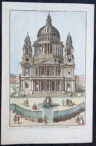
1770 Louis-Joseph Mondhare Antique Print View of St Pauls Cathedral, London UK
- Title : Le Portail de la grande Eglise de St Paul de Londre...a Paris chez Mondhare ru st Jacques
- Ref #: 93460
- Size: 15in x 9 1/2in (380mm x 235mm)
- Date : 1770
- Condition: (A+) Fine Condition
Description:
This original hand coloured copper plate engraved antique print of St Pauls Cathedral, London was engraved and published by Louis-Joseph Mondhare in Paris in 1770
General Definitions:
Paper thickness and quality: - Heavy and stable
Paper color : - off white
Age of map color: - Early
Colors used: - Blue, pink, red, green, yellow
General color appearance: - Authentic
Paper size: - 15in x 9 1/2in (380mm x 235mm)
Plate size: - 13in x 9in (330mm x 230mm)
Margins: - Min 1/2in (12mm)
Imperfections:
Margins: - None
Plate area: - None
Verso: - None
Background:
The task of designing a replacement structure was officially assigned to Sir Christopher Wren on 30 July 1669. He had previously been put in charge of the rebuilding of churches to replace those lost in the Great Fire. More than 50 City churches are attributable to Wren. Concurrent with designing St Pauls, Wren was engaged in the production of his five Tracts on Architecture.
Wren had begun advising on the repair of the Old St Pauls in 1661, five years before the fire in 1666. The proposed work included renovations to interior and exterior to complement the classical facade designed by Inigo Jones in 1630. Wren planned to replace the dilapidated tower with a dome, using the existing structure as a scaffold. He produced a drawing of the proposed dome which shows his idea that it should span nave and aisles at the crossing. After the Fire, it was at first thought possible to retain a substantial part of the old cathedral, but ultimately the entire structure was demolished in the early 1670s.
In July 1668 Dean William Sancroft wrote to Wren that he was charged by the Archbishop of Canterbury, in agreement with the Bishops of London and Oxford, to design a new cathedral that was Handsome and noble to all the ends of it and to the reputation of the City and the nation. The design process took several years, but a design was finally settled and attached to a royal warrant, with the proviso that Wren was permitted to make any further changes that he deemed necessary. The result was the present St Pauls Cathedral, still the second largest church in Britain, with a dome proclaimed as the finest in the world. The building was financed by a tax on coal, and was completed within its architects lifetime with many of the major contractors engaged for the duration.
The topping out of the cathedral (when the final stone was placed on the lantern) took place on 26 October 1708, performed by Wrens son Christopher Jr and the son of one of the masons. The cathedral was declared officially complete by Parliament on 25 December 1711 (Christmas Day). In fact, construction continued for several years after that, with the statues on the roof added in the 1720s. In 1716 the total costs amounted to £1,095,556 (£165 million in 2019).
On 2 December 1697, 31 years and 3 months after the Great Fire destroyed Old St Pauls, the new cathedral was consecrated for use. The Right Reverend Henry Compton, Bishop of London, preached the sermon. It was based on the text of Psalm 122, I was glad when they said unto me: Let us go into the house of the Lord. The first regular service was held on the following Sunday.
Opinions of Wrens cathedral differed, with some loving it: Without, within, below, above, the eye / Is filled with unrestrained delight, while others hated it: There was an air of Popery about the gilded capitals, the heavy arches ... They were unfamiliar, un-English
Mondhare & Jean (active 1759 - 1829)
Louis-Joseph Mondhare (1734 - Paris 1799) & Pierre Jean (1754 - 1829) were prominent Parisian publishers, engravers, print and map sellers who were active in Paris in the late 18th and early 19th centuries.
In 1784 Jean married the daughter of Mondhare, who formed a partnership with his son in law, changing forming a very successful partnership thereafter as Mondhare & Jean.
After Mondhare retirement in 1796, Jean carried on with the publishing & printing business, having inherited all of the printing plates that also included many map plates from the likes of Nolin, Clouet, D Anville , Delsile and others. Both Mondhare and Jean were responsible for the engraving and printing of the very decorative large wall maps by J B Nolin & J B L Clouet, as well as single plate maps and atlases. Mondares premises were located at Rue St Jacques, à lHôtel Saumur later movin
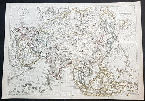
1830 Jean Baptiste Clouet & Pierre Jean Large Antique Map of Asia..Wall Map
- Title : Carte de L Asie, Divisee En Ses Differents Empires et Royaumes Avec...Dressee par J B Nolin...1830
- Ref #: 93437
- Size: 31in x 22in (790mm x 560mm)
- Date : 1780 (1830)
- Condition: (A+) Fine Condition
Description:
This large original hand coloured copper-plate engraved antique map of Asia was engraved and published by Pierre Jean, of the Parisian publishing company Mondhare and Jean in 1830, after the 18th century French cartographer Jean Baptiste Clouet and not Jean Baptiste Nolin jr as noted in the title.
This map is also incredibly rare and I have been unable to find another example sold in the last 25 years.
Since acquiring this large original map, it has been somewhat of an enigma. It is dated 1830 but bears the name of the cartographer J B Nolin, who died in 1790. It was engraved and published by Pierre Jean. But the map bears no cartographical resemblance to any large maps of Asia by Nolin and is also too large to fit into any atlas by Nolin or published by Pierre Jean. This clue finally gave us the answer. The Mondhare and Jean engraving & publishing company were responsible for engraving and printing Jean Baptiste Nolins large world & continental wall maps. And at the same time they were also responsible for the engraving & publishing a series of Wall maps of the world & continents by J B Clouet at the end of the 18th century. These maps are somewhat similar in decoration but are very different in cartographical detail as you can see in the two image comparisons above. This map was published a year after the death of Pierre Jean and we possibly never know it was a mistake or intentional.
General Definitions:
Paper thickness and quality: - Heavy and stable
Paper color : - off white
Age of map color: - Original
Colors used: - Yellow, green, blue, pink
General color appearance: - Authentic
Paper size: - 31in x 22in (790mm x 560mm)
Plate size: - 29 1/2in x 21in (750mm x 535mm)
Margins: - Min 1/2in (12mm)
Imperfections:
Margins: - None
Plate area: - Very small rust hole in Siberia
Verso: - Bottom centerfold rejoined, no loss
Background:
Cartographically the only apparent difference between this map by Jean and the map by Clouet is the updated cartographical data in the inset map of the Bering Straits and the updated information by the surveying by Captain James Cook and others after the 1780s.
Jean Baptiste Clouet 1729 - 1790 Clouet was a French cartographer and geographer born in Rennes, France. He kept premises in both Paris & Cadiz, Spain and was named Royal Geographer of the Academie des Sciences de Rouen in 1785. One of his main works was Géographie Moderne first issued 1767. In 1788 he was responsible for the design of 5 World & Continental wall maps, engraved and printed by the famous Paris publishers Mondhare & Jean.
Jean Baptiste Nolin Jr 1686–1762, son of JB Nolin 1657 - 1708 carried on publishing his fathers stock after his death, contracting the printing to third party publishing companies.
Mondhare & Jean (active 1759 - 1829)
Louis-Joseph Mondhare (1734 - Paris 1799) & Pierre Jean (1754 - 1829) were prominent Parisian publishers, engravers, print and map sellers who were active in Paris in the late 18th and early 19th centuries.
In 1784 Jean married the daughter of Mondhare, who formed a partnership with his son in law, changing forming a very successful partnership thereafter as Mondhare & Jean.
After Mondhare retirement in 1796, Jean carried on with the publishing & printing business, having inherited all of the printing plates that also included many map plates from the likes of Nolin, Clouet, D Anville , Delsile and others. Both Mondhare and Jean were responsible for the engraving and printing of the very decorative large wall maps by J B Nolin & J B L Clouet, as well as single plate maps and atlases. Mondares premises were located at Rue St Jacques, à lHôtel Saumur later moving with Jean to 32 Rue Saint-Jean de Beauvais.