Matthaus Merian
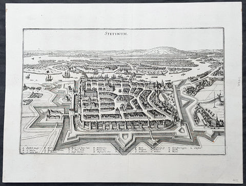
1652 Merian Antique Map Birds Eye View of the City of Szczecin or Stettin Poland
- Title : Stetinum
- Ref #: 93492
- Size: 15 1/2in x 11 1/2in (385mm x 295mm)
- Date : 1652
- Condition: (A+) Fine Condition
Description:
This original copper-plate engraved antique map a birds-eye view of the city of Szczecin or Stettin, then located in Germany, now Poland, by Matthaus Merian was published in the 1652 edition of Theatrum Europaeum
General Definitions:
Paper thickness and quality: - Heavy and stable
Paper color : - off white
Age of map color: -
Colors used: -
General color appearance: -
Paper size: - 15 1/2in x 11 1/2in (385mm x 295mm)
Plate size: - 13 1/2in x 8 1/2in (335mm x 210mm)
Margins: - Min 1in (25mm)
Imperfections:
Margins: - None
Plate area: - None
Verso: - None
Background:
Szczecin/Stettin is the capital and largest city of the West Pomeranian Voivodeship in northwestern Poland. Located near the Baltic Sea and the German border, it is a major seaport and Polands seventh-largest city.
Szczecin is located on the river Oder, south of the Szczecin Lagoon and the Bay of Pomerania. The city is situated along the southwestern shore of Dąbie Lake, on both sides of the Oder and on several large islands between the western and eastern branches of the river. Szczecin is adjacent to the town of Police and is the urban centre of the Szczecin agglomeration, an extended metropolitan area that includes communities in the German states of Brandenburg and Mecklenburg-Vorpommern.
The cities recorded history began in the 8th century as a Lechitic Pomeranian stronghold, built at the site of the Ducal castle. In the 12th century, when Szczecin had become one of Pomeranias main urban centres, it lost its independence to Piast Poland, the Duchy of Saxony, the Holy Roman Empire and Denmark. At the same time, the House of Griffins established themselves as local rulers and the population was Christianized. After the Treaty of Stettin in 1630, the town came under the control of the Swedish Empire and became in 1648 the Capital of Swedish Pomerania until 1720, when it was acquired by the Kingdom of Prussia and then the German Empire. Following World War II Stettin became part of Poland in accordance with the Potsdam Agreement, resulting in the almost complete expulsion of the pre-war German population.
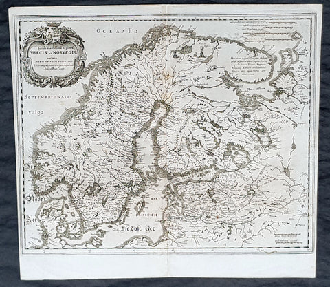
1653 Matthaus Merian Antique Map of Scandinavia Norway, Sweden, Denmark, Finland
- Title : Tabula exantissima Reguora Sueciae et Norvegiae...Andcea Buze o Sueco
- Date : 1635
- Condition: (A+) Fine Condition
- Ref: 35504
- Size: 14 1/4in x 13 1/4in (360mm x 335mm)
Description:
This fine original copper-plate engraved antique map of Scandinavia, Norway, Sweden, Denmark, Finland & Baltic States by Matthaus Merian was published in Theatrum Europaeum in 1635.
General Definitions:
Paper thickness and quality: - Heavy and stable
Paper color : - off white
Age of map color: -
Colors used: -
General color appearance: -
Paper size: - 14 1/4in x 13 1/4in (360mm x 335mm)
Plate size: - 14in x 13in (355mm x 325mm)
Margins: - Min 1/4in (5mm)
Imperfections:
Margins: - None
Plate area: - None
Verso: - None
Background:
Before the fifteenth century the people of Southern Europe had little geographical knowledge of the Scandinavian World except from sketchy detail shown in the Catalan Atlas (1375) and on a number of \\\" portolani\\\" embracing Denmark and the southern tip of Norway. It was not until 1427 that a manuscript map prepared about that time by Claudius Clavus (b.1388) a Dane who spent some time in Rome, made available to scholars a tolerable outline of the northern countries and Greenland. That was to remain the best map available for the rest of the century and it was used as the basis for maps of Scandinavia in early printed editions of Ptolemy. Others by Nicolaus Cusanus (1491) and Ehrhard Etzlaub (c. 1492) followed but, needless to say, these are extremely rare; even the later maps by Olaus Magnus and Marcus Jordan, where they have survived at all , are known only by a very few examples. In fact, apart from the rare appearance of an early Ptolemy map, the oldest of Scandinavia which a collector is likely to find are those of Munster\\\'s Cosmograhy first published in 1544. In the following centuries the few maps and charts complied in Scandinavia were usually published in Amsterdam, Antwerp, Paris or Nuremberg, the most important maps often being incorporated in the major Dutch, French & German Atlases. (Ref: Tooley; M&B)
Merian, Matthaus 1593 - 1650
Merian was a Swiss-born engraver who worked in Frankfurt for most of his career, where he also ran a publishing house. He was a member of the patrician Basel Merian family.
Born in Basel, Merian learned the art of copperplate engraving in Zürich. He next worked and studied in Strasbourg, Nancy, and Paris, before returning to Basel in 1615. The following year he moved to Frankfurt, Germany where he worked for the publisher Johann Theodor de Bry, who was the son of renowned engraver and traveler Theodor de Bry.
In 1617, Merian married Maria Magdalena de Bry, daughter of the publisher, and was for a time associated with the de Bry publishing house. In 1620 they moved back to Basel, but three years later returned to Frankfurt. They had four daughters and three sons, including Matthäus Merian the Younger. Maria Magdalena de Bry died in 1645 and the following year Matthäus married Johanna Catharina Hein. Five years later, Matthäus died, leaving his wife with two small children, Anna Maria Sibylla Merian (born 1647) who later became a pioneering naturalist and illustrator and a son, Maximilian, who died before his third birthday.
In 1623 Merian took over the publishing house of his father-in-law after de Brys death. In 1626 he became a citizen of Frankfurt and could henceforth work as an independent publisher. He spent most of his working life in Frankfurt.
Early in his life, he had created detailed town plans in his unique style, e.g. a plan of Basel (1615) and a plan of Paris (1615). With Martin Zeiler (1589 - 1661), a German geographer, and later (circa 1640) with his own son, Matthäus Merian (der Jüngere, i.e.the Younger or Jr.) (1621 - 1687), he produced a series of Topographia. The 21-volume set was collectively known as the Topographia Germaniae. It includes numerous town plans and views, as well as maps of most countries and a World Map—it was such a popular work that it was re-issued in many editions. He also took over and completed the later parts and editions of the Grand Voyages and Petits Voyages, originally started by de Bry in 1590.
Merians work inspired the Suecia Antiqua et Hodierna by Erik Dahlberg. The German travel magazine Merian is named after him.
He was also noted for the finesse of his alchemical illustrations, in books such as the Musaeum Hermeticum (1678) and Atalanta Fugiens (1618).
Matthäus Merian died after several years of illness in 1650 in Langenschwalbach, near Wiesbaden.
After his death, his sons Matthäus Jr. and Caspar took over the publishing house. They continued publishing the Topographia Germaniae and the Theatrum Europaeum under the name Merian Erben (i.e. Merian Heirs).
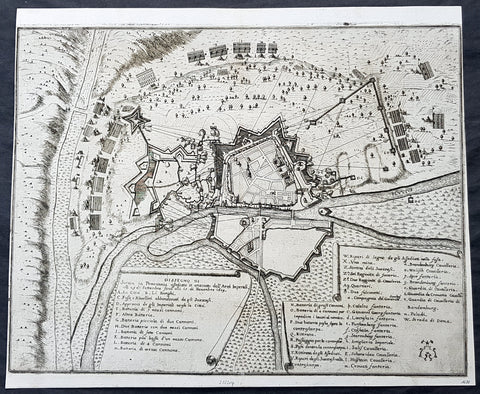
1675 Merian Antique Map Birds Eye View Siege of Szczecin, Stettin Poland in 1659
- Title : Abzeichnung der Belägerung der Statt Stettin in Pommeren wie dieselbe von denen Kayserlichen vom 29.Sept. biß auf den 15. Novemb. Anno 1659 angegriffen und bestritten worden
- Ref #: 93491
- Size: 15 1/2in x 13in (395mm x 340mm)
- Date : 1675
- Condition: (A+) Fine Condition
Description:
This original copper-plate engraved antique map a birds-eye view of the siege of Szczecin or Stettin, Poland in 1659 - with illustrations of military positions surrounding the city - by Matthaus Merian was published in the 1675 edition of Theatrum Europaeum
During the Thirty Years War, Stettin refused to accept German imperial armies, instead the Pomeranian dukes allied with Sweden. After the Treaty of Stettin (1630) manifested Swedish occupation, Stettin was fortified by the Swedish Empire. After the death of the last Pomeranian duke, Boguslaw XIV, Stettin was awarded to Sweden with the western part of the duchy in the Peace of Westphalia (1648), but remained part of the Holy Roman Empire. The Swedish-Brandenburgian border was settled in the Treaty of Stettin (1653). The King of Sweden became Duke of Pomerania and as such held a seat in the Imperial Diet of the Holy Roman Empire. The city was cut off from its main trading area, and was besieged in several wars with Brandenburg which shattered the citys economy, which fell in prolonged economic decline.
In 1654 the last Pomeranian duke Boguslaw XIV was buried in the Ducal Castle.
General Definitions:
Paper thickness and quality: - Heavy and stable
Paper color : - off white
Age of map color: -
Colors used: -
General color appearance: -
Paper size: - 15 1/2in x 13in (395mm x 340mm)
Plate size: - 15 1/2in x 13in (395mm x 340mm)
Margins: - Min 1/8in (2mm)
Imperfections:
Margins: - Left margin cropped close to border
Plate area: - None
Verso: - None
Background:
Szczecin/Stettin is the capital and largest city of the West Pomeranian Voivodeship in northwestern Poland. Located near the Baltic Sea and the German border, it is a major seaport and Polands seventh-largest city.
Szczecin is located on the river Oder, south of the Szczecin Lagoon and the Bay of Pomerania. The city is situated along the southwestern shore of Dąbie Lake, on both sides of the Oder and on several large islands between the western and eastern branches of the river. Szczecin is adjacent to the town of Police and is the urban centre of the Szczecin agglomeration, an extended metropolitan area that includes communities in the German states of Brandenburg and Mecklenburg-Vorpommern.
The cities recorded history began in the 8th century as a Lechitic Pomeranian stronghold, built at the site of the Ducal castle. In the 12th century, when Szczecin had become one of Pomeranias main urban centres, it lost its independence to Piast Poland, the Duchy of Saxony, the Holy Roman Empire and Denmark. At the same time, the House of Griffins established themselves as local rulers and the population was Christianized. After the Treaty of Stettin in 1630, the town came under the control of the Swedish Empire and became in 1648 the Capital of Swedish Pomerania until 1720, when it was acquired by the Kingdom of Prussia and then the German Empire. Following World War II Stettin became part of Poland in accordance with the Potsdam Agreement, resulting in the almost complete expulsion of the pre-war German population.

1682 Merian Antique Map Birds Eye View of the Siege of Szczecin, Stettin Poland
- Title : Abbildung der voortrefflichen Langwerenden Belägerung der Statt und Vöstung Alt Stettin . Im Jahr 1677
- Ref #: 93495
- Size: 15 1/2in x 13 1/2in (395mm x 345mm)
- Date : 1682
- Condition: (A+) Fine Condition
Description:
This original copper-plate engraved antique map a birds-eye view of the siege of Szczecin or Stettin, Poland in 1677 by Matthaus Merian was published in the 1682 edition of Theatrum Europaeum
During the Thirty Years War, Stettin refused to accept German imperial armies, instead the Pomeranian dukes allied with Sweden. After the Treaty of Stettin (1630) manifested Swedish occupation, Stettin was fortified by the Swedish Empire. After the death of the last Pomeranian duke, Boguslaw XIV, Stettin was awarded to Sweden with the western part of the duchy in the Peace of Westphalia (1648), but remained part of the Holy Roman Empire. The Swedish-Brandenburgian border was settled in the Treaty of Stettin (1653). The King of Sweden became Duke of Pomerania and as such held a seat in the Imperial Diet of the Holy Roman Empire. The city was cut off from its main trading area, and was besieged in several wars with Brandenburg which shattered the citys economy, which fell in prolonged economic decline.
In 1654 the last Pomeranian duke Boguslaw XIV was buried in the Ducal Castle.
General Definitions:
Paper thickness and quality: - Heavy and stable
Paper color : - off white
Age of map color: -
Colors used: -
General color appearance: -
Paper size: - 15 1/2in x 13 1/2in (395mm x 345mm)
Plate size: - 11in x 10in (280mm x 255mm)
Margins: - Min 1/2in (12mm)
Imperfections:
Margins: - None
Plate area: - None
Verso: - None
Background:
Szczecin/Stettin is the capital and largest city of the West Pomeranian Voivodeship in northwestern Poland. Located near the Baltic Sea and the German border, it is a major seaport and Polands seventh-largest city.
Szczecin is located on the river Oder, south of the Szczecin Lagoon and the Bay of Pomerania. The city is situated along the southwestern shore of Dąbie Lake, on both sides of the Oder and on several large islands between the western and eastern branches of the river. Szczecin is adjacent to the town of Police and is the urban centre of the Szczecin agglomeration, an extended metropolitan area that includes communities in the German states of Brandenburg and Mecklenburg-Vorpommern.
The cities recorded history began in the 8th century as a Lechitic Pomeranian stronghold, built at the site of the Ducal castle. In the 12th century, when Szczecin had become one of Pomeranias main urban centres, it lost its independence to Piast Poland, the Duchy of Saxony, the Holy Roman Empire and Denmark. At the same time, the House of Griffins established themselves as local rulers and the population was Christianized. After the Treaty of Stettin in 1630, the town came under the control of the Swedish Empire and became in 1648 the Capital of Swedish Pomerania until 1720, when it was acquired by the Kingdom of Prussia and then the German Empire. Following World War II Stettin became part of Poland in accordance with the Potsdam Agreement, resulting in the almost complete expulsion of the pre-war German population.
Merian, Matthaus 1593 - 1650
Merian was a Swiss-born engraver who worked in Frankfurt for most of his career, where he also ran a publishing house. He was a member of the patrician Basel Merian family.
Born in Basel, Merian learned the art of copperplate engraving in Zürich. He next worked and studied in Strasbourg, Nancy, and Paris, before returning to Basel in 1615. The following year he moved to Frankfurt, Germany where he worked for the publisher Johann Theodor de Bry, who was the son of renowned engraver and traveler Theodor de Bry.
In 1617, Merian married Maria Magdalena de Bry, daughter of the publisher, and was for a time associated with the de Bry publishing house. In 1620 they moved back to Basel, but three years later returned to Frankfurt. They had four daughters and three sons, including Matthäus Merian the Younger. Maria Magdalena de Bry died in 1645 and the following year Matthäus married Johanna Catharina Hein. Five years later, Matthäus died, leaving his wife with two small children, Anna Maria Sibylla Merian (born 1647) who later became a pioneering naturalist and illustrator and a son, Maximilian, who died before his third birthday.
In 1623 Merian took over the publishing house of his father-in-law after de Brys death. In 1626 he became a citizen of Frankfurt and could henceforth work as an independent publisher. He spent most of his working life in Frankfurt.
Early in his life, he had created detailed town plans in his unique style, e.g. a plan of Basel (1615) and a plan of Paris (1615). With Martin Zeiler (1589 - 1661), a German geographer, and later (circa 1640) with his own son, Matthäus Merian (der Jüngere, i.e.the Younger or Jr.) (1621 - 1687), he produced a series of Topographia. The 21-volume set was collectively known as the Topographia Germaniae. It includes numerous town plans and views, as well as maps of most countries and a World Map—it was such a popular work that it was re-issued in many editions. He also took over and completed the later parts and editions of the Grand Voyages and Petits Voyages, originally started by de Bry in 1590.
Merians work inspired the Suecia Antiqua et Hodierna by Erik Dahlberg. The German travel magazine Merian is named after him.
He was also noted for the finesse of his alchemical illustrations, in books such as the Musaeum Hermeticum (1678) and Atalanta Fugiens (1618).
Matthäus Merian died after several years of illness in 1650 in Langenschwalbach, near Wiesbaden.
After his death, his sons Matthäus Jr. and Caspar took over the publishing house. They continued publishing the Topographia Germaniae and the Theatrum Europaeum under the name Merian Erben (i.e. Merian Heirs).