John Russell
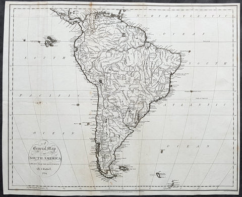
1794 John Russell Large Antique Map of South America
- Title : A General Map of South America Drawn fro the Best Surveys by J Russell 1794
- Ref #: 92579
- Size: 18 1/2in x 15in (470mm x 380mm)
- Date : 1794
- Condition: (A) Good Condition
Description:
This large original copper-plate engraved antique map of South America by John Russell was published by H D Symonds in 1794 - dated. (Ref Tooley M&B)
General Definitions:
Paper thickness and quality: - Heavy and stable
Paper color : - off white
Age of map color: -
Colors used: -
General color appearance: -
Paper size: - 18 1/2in x 15in (470mm x 380mm)
Plate size: - 18 1/2in x 15in (470mm x 380mm)
Margins: - Min 1/4in (5mm)
Imperfections:
Margins: - None
Plate area: - Folds as issued, small repair to left fold & right side of image no loss
Verso: - Folds as issued, soiling along folds
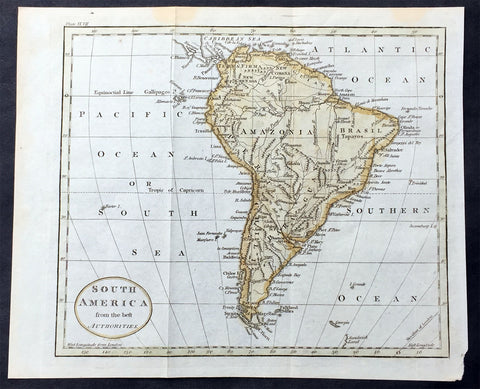
1797 John Russell Old, Antique Map of South America
- Title : South America from the best Authorities
- Ref : 70198
- Size: 10in x 8in (255mm x 205mm)
- Date : 1797
- Condition: (A+) Fine Condition
Description:
This fine hand coloured original antique map of South America was engraved in 1797 by John Russell and published by Charles Dilly & John Robinson. London.(Ref: M&B; Tooley)
General Description:
Paper thickness and quality: - Light & stable
Paper color: - White
Age of map color: - Early
Colors used: - Red, green, orange
General color appearance: - Authentic
Paper size: - 10in x 8in (260mm x 205mm)
Plate size: - 10in x 8in (260mm x 205mm)
Margins: - Min 1/2in (12mm)
Imperfections:
Margins: - None
Plate area: - Folds as issued
Verso: - None

1797 John Russell Old, Antique Map of The Great Lakes & Canada, North America
- Title : British Colonies in North America from the best Authorities
- Ref : 70195
- Size: 10in x 8in (255mm x 205mm)
- Date : 1797
- Condition: (A+) Fine Condition
Description:
This fine hand coloured original antique map of Canada and the Great Lakes was engraved in 1797 - dated at foot of map - by John Russell and published by Charles Dilly & John Robinson, London. (Ref: M&B; Tooley)
General Description:
Paper thickness and quality: - Light & stable
Paper color: - White
Age of map color: - Early
Colors used: - Red, green, orange
General color appearance: - Authentic
Paper size: - 10in x 8in (260mm x 205mm)
Plate size: - 10in x 8in (260mm x 205mm)
Margins: - Min 1/2in (12mm)
Imperfections:
Margins: - None
Plate area: - Folds as issued
Verso: - None