John Marshall
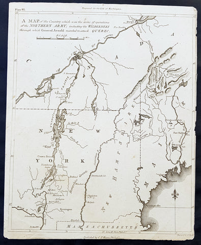
1804 J Marshall Original Antique American Revolutionary War Map Battle of Quebec
- Title : A Map of the Country which was the scene of operations of the Northern Army; including the Wilderness through which General Arnold marched to attack Quebec
- Size: 11in x 9in (280mm x 225mm)
- Ref #: 35091
- Date : 1804
- Condition: (A) Very Good Condition
Description:
This fine original copper-plate engraved antique map of the Battle of Quebec - covering New York, New Hampshire and Quebec Canada - in December 1775 during the American Revolutionary War, was published in the first 1804 edition of John Marshalls The Life of George Washington, Commander in Chief of the American Forces, during the War which established the Independence of his Country.............
General Definitions:
Paper thickness and quality: - Heavy and stable
Paper color : - off white
Age of map color: -
Colors used: -
General color appearance: -
Paper size: - 11in x 9in (280mm x 225mm)
Plate size: - 11in x 9in (280mm x 225mm)
Margins: - Min 1/8in (2mm)
Imperfections:
Margins: - Right margin cropped close to border
Plate area: - Light vertical crease as issued
Verso: - None
Background:
The Battle of Quebec was fought on December 31, 1775, between American Continental Army forces and the British defenders of Quebec City early in the American Revolutionary War. The battle was the first major defeat of the war for the Americans, and it came with heavy losses. General Richard Montgomery was killed, Benedict Arnold was wounded, and Daniel Morgan and more than 400 men were taken prisoner. The city\'s garrison, a motley assortment of regular troops and militia led by Quebec\'s provincial governor, General Guy Carleton, suffered a small number of casualties.
Montgomery\'s army had captured Montreal on November 13, and early in December they joined a force led by Arnold, whose men had made an arduous trek through the wilderness of northern New England. Governor Carleton had escaped from Montreal to Quebec, the Americans\' next objective, and last-minute reinforcements arrived to bolster the city\'s limited defenses before the attacking force\'s arrival. Concerned that expiring enlistments would reduce his force, Montgomery made the end-of-year attack in a blinding snowstorm to conceal his army\'s movements. The plan was for separate forces led by Montgomery and Arnold to converge in the lower city before scaling the walls protecting the upper city. Montgomery\'s force turned back after he was killed by cannon fire early in the battle, but Arnold\'s force penetrated further into the lower city. Arnold was injured early in the attack, and Morgan led the assault in his place before he became trapped in the lower city and was forced to surrender. Arnold and the Americans maintained an ineffectual blockade of the city until spring, when British reinforcements arrived.
In the battle and the following siege, French-speaking Canadians were active on both sides of the conflict. The American forces received supplies and logistical support from local residents, and the citys defenders included locally raised militia. When the Americans retreated, they were accompanied by a number of their supporters; those who remained behind were subjected to a variety of punishments after the British re-established control over the province.
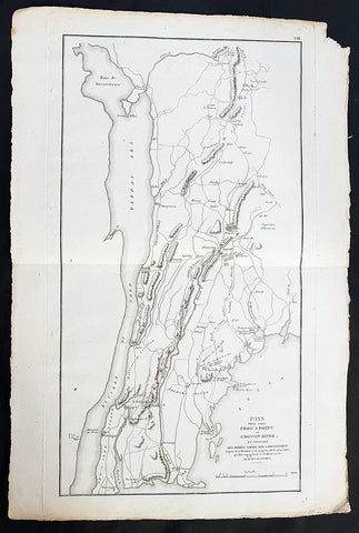
1807 John Marshall Antique Map Battle of Pells Point in The Bronx, NYC in 1776
- Title: Pays Situe Entre Frogs Point et Croton River, et Position Des Armees Americaine et Brittannique....1776
- Date: 1807
- Ref: 33645
- Size: 18in x 12in (460mm x 305mm)
- Condition: - (A+) Fine Condition
Description:
This fine large original copper-plate engraved antique map of the Battle of Pells Point, also known as the Battle of Pelham, a conflict that took place in what is now part of Pelham Bay Park in the Bronx, New York City the golf courses of Split Rock Golf Course & Pelham Bay Golf Course in The Bronx, New York City, in October 1776 during the American Revolutionary War, was published in the 1807 French edition of John Marshall\'s The Life of George Washington.
General Definitions:
Paper thickness and quality: - Heavy and stable
Paper color : - off white
Age of map color: -
Colors used: -
General color appearance: -
Paper size: - 18in x 12in (460mm x 305mm)
Plate size: - 18in x 10in (460mm x 255m)
Margins: - Min 1/2in (12mm)
Imperfections:
Margins: - None
Plate area: - None
Verso: - None
Background:
The Battle of Pell\'s Point (October 18, 1776), also known as the Battle of Pelham, was a skirmish fought between British and American troops during the New York and New Jersey campaign of the American Revolutionary War. The conflict took place in what is now part of Pelham Bay Park in the Bronx, New York City the golf courses of Split Rock Golf Course & Pelham Bay Golf Course in The Bronx, New York City and the towns of Pelham Manor and Pelham in Westchester County, NY.
On October 12, British forces landed at Throgs Neck in order to execute a flanking maneuver that would trap Gen. George Washington, commander-in-chief of the American revolutionary forces, and the main body of the Continental Army on the island of Manhattan. The Americans thwarted the landing, and Gen. Sir William Howe, commander-in-chief of British forces in North America, looked for another location along Long Island Sound to disembark his troops. On October 18, he landed 4,000 men at Pelham, 3 miles north of Throgs Neck. Inland were 750 men of a brigade under the command of the American Col. John Glover. Glover positioned his troops behind a series of stone walls and attacked the British advance units. As the British overran each position, the American troops fell back and reorganized behind the next wall. After several such attacks, the British broke off, and the Americans retreated.
The battle delayed British movements long enough for Washington to move the main army to White Plains and avoid being surrounded on Manhattan. After losing to the British in a battle at White Plains, and losing Fort Washington, Washington retreated across New Jersey to Pennsylvania.
At dawn, the British began to land on the shore, Clinton\'s advance guard of 4,000 British light infantry and Hessian jägers landing first. Inland, opposing them, was a brigade of some 750 men under the command of John Glover. Glover was atop a hill with a telescope when he noticed the British ships. (hill on the west side of the Hutchinson River Parkway and the Hutchinson River on East Sanford Blvd. in Mount Vernon, NY on the opposite side of the Hutchinson River Parkway and Pelham Memorial High School) Glover sent an officer, Major William Lee, to report to Charles Lee, Washington\'s second in command, and ask for orders. However, Lee did not give any orders, and in the absence of orders Glover chose to attack. Glover turned out his brigade, which consisted of the 14th, 13th, 3rd and the 26th Continental Regiments. Glover left the 150 men of the 14th Continentals behind in reserve. Glover had not closed half the distance when he ran into approximately 30 skirmishers. Glover ordered a Captain and his 40-man company forward as an advance guard to hold the British in check, while Glover organized the rest of the force.
Glover prepared an ambush by placing the main body in staggered positions behind the stone walls that lined either side of the laneway leading from the beachhead to the interior. Glover instructed each of the regiments to hold their position as long as they could and then to fall back to a position in the rear, while the next unit took up the fighting. Glover then rode up to take command of the advance guard. The advance guard and the British began to engage each other, both sides taking casualties. After a little while the British were reinforced, and Glover ordered a retreat, which was done without confusion. The British troops began to advance at the retreating Americans. However, the 200 troops of the 13th Continentals that Glover had stationed behind the stone wall stood up and fired at the British when there were only 30 yards away. The ambush worked, and the column of British troops took heavy losses and fell back to the main body of the invading army.
The British waited half an hour before attacking again. This time when they attacked, they attacked with all 4,000 men and seven cannon. The British bombarded the American position behind the stone wall as their infantry advanced. The cannon fire was ineffective, and when the British were 50 yards away the Americans fired a volley which stopped the British infantry. The British returned fire, and musket and rifle fire ensued for 20 minutes, the British supported by cannon, at which point the lead American regiment fell back under cover of the next reserve regiment. The 3rd Continental Regiment was stationed behind the stone wall on the opposite side of the road.
The British attacked the position of the 3rd Continentals, and an engagement ensued. Both sides kept up constant fire, the Americans breaking the British lines several times. However, after 17 volleys, the British numbers began to overwhelm the Americans, and Glover ordered a withdrawal to another stone wall on the crest of a hill while the next regiment in line, the 26th Continentals, engaged the British.
A reconnaissance party of 30 men was sent out from behind the third stone wall to see if the British would try and flank the American position. The party ran into the British, who had continued to advance, and they fell back to the stone wall. The Americans behind the wall fired one volley before Glover gave the order to retreat. The Americans retreated across a bridge over the Hutchinson stream, their retreat covered by the 150 men of the 14th Continentals who engaged in an artillery duel with the British. Howe camped on a hill on the opposite side of the stream but made no attempt to cross the stream.
The next day, Glover and his force retreated to the town of Yonkers. American casualties were 8 killed and 13 wounded. British and Hessian casualties are not known. Howes official dispatch listed British casualties as 3 killed and 20 wounded, although the report did not include Hessian casualties. As the Hessians made up the majority of the landing force, it is reasonable to expect they made up the majority of the casualties. Over the next few days, from knowledge collected from British deserters, the Americans estimated that the British lost between 800 and 1,000 killed or wounded, likely an exaggeration. Colonel Loammi Baldwin, (an officer and fruit fancier whose fame came in the Baldwin apple) who was present at the battle, estimated that the Americans had killed 200 British and Hessians, but historian David McCullough says this was undoubtedly an exaggeration. Historian George Athan Billias argues in support of Baldwin\'s estimates, due in part to the corroborating admission of another British deserter. Regardless, the combined British and Hessian casualties were almost certainly larger than those of the Americans.
With the British advance delayed, the main American army under Washington was able to safely evacuate from Harlem (on the island of Manhattan) to White Plains. Howe slowly moved his army through New Rochelle and Scarsdale. On October 28, he sent 13,000 men to attack the Americans, resulting in a minor victory over Washington at the Battle of White Plains. Fort Washington, the last American stronghold on Manhattan, fell on November 16. With these defeats, Washington and his army retreated across New Jersey and into Pennsylvania, paving the way for the Battles of Trenton and Princeton.
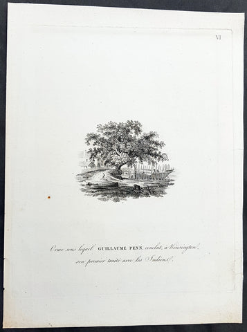
1807 Marshall Antique Print Pennsylvania Treaty Elm, W Penn & Lenape Indian 1683
- Title : Orme sous lequel Guillaume Penn, conclut, a Kensington, son primier traite avec les Indiancl.
- Size: 11 1/2in x 9in (295mm x 230mm)
- Ref #: 33641
- Date : 1807
- Condition: (A+) Fine Condition
Description:
This fine original copper-plate engraved antique print of the Treaty Elm, where William Penn signed a Treaty with the Lenape Indians in 1683, was published in the 1807 French edition of John Marshall\'s The Life of George Washington.
This 5 volume publication outlined the life & times of Washington, containing an atlas volume with numerous maps and engravings of the campaigns and battles of Washington from the American Revolutionary Wars. (Ref: Tooley; M&B)
General Definitions:
Paper thickness and quality: - Heavy and stable
Paper color : - off white
Age of map color: -
Colors used: -
General color appearance: -
Paper size: - 11 1/2in x 9in (295mm x 230mm)
Plate size: - 10in x 8in (255mm x 205mm)
Margins: - Min 1in (25mm)
Imperfections:
Margins: - None
Plate area: - None
Verso: - None
Background:
In the year 1683, the land that is now Penn Treaty Park was part of the Lenape village of Shackamaxon. Under an elm tree immortalized in a painting by Benjamin West, William Penn famously entered into a treaty of peace with a chief of the Lenape Turtle Clan named Tamanend (later referred to by the Dutch as Tammany or Saint Tammany).
Penn, unarmed in accord with Quaker custom and speaking the Algonquian language, proclaimed that, We meet on the broad pathway of good faith and good-will; no advantage shall be taken on either side, but all shall be openness and love. We are the same as if one man’s body was to be divided into two parts; we are of one flesh and one blood. Tamanend replied, We will live in love with William Penn and his children as long as the creeks and rivers run, and while the sun, moon, and stars endure.
This peace between the Lenape Turtle Clan and Penn\'s successors would endure almost a century, until the Penn\'s Creek Massacre of 1755. It was remarked upon by Voltaire, who called it ... the only treaty never sworn to and never broken.
This location became part of the Fairman Estate and was purchased by Captain Anthony Palmer around 1730 just before he founded the town of Kensington.
The famous elm tree under which the treaty was conducted fell during a storm in 1810. Soon thereafter, a monument was erected on the site where the elm tree was located to commemorate the treaty. The small obelisk remained tucked away in the northwest corner of a lumber yard that sat on the site, until actions were taken in 1893 to acquire the land and build the park that exists today. The park officially opened on October 28, 1893.
After the original tree fell, the Oliver and Vanduzen families took cuttings and seedlings from the tree at that time. They gave offspring of the great Elm to Pennsylvania Hospital, University of Pennsylvania and Haverford College.
On May 6, 2010 at Penn Treaty Park an Elm Tree descendant was planted again. Haverford College Arboretum donated a descendant of the Treaty Elm. The Friends of Penn Treaty Park provided the funding to transport the tree and plant the new tree. Pastor Norwood, from the Tribal Council of the Nanticoke Lenni Lenape and Board member of the Penn Treaty Museum provided a blessing. Fairmount Park assisted.
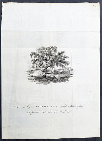
1807 Marshall Antique Print Pennsylvania Treaty Elm, W Penn & Lenape Indian 1683
- Title : Orme sous lequel Guillaume Penn, conclut, a Kensington, son primier traite avec les Indiancl.
- Size: 10 1/2in x 7 3/4in (265mm x 195mm)
- Ref #: 50122
- Date : 1807
- Condition: (A) Very Good Condition
Description:
This fine original copper-plate engraved antique print of the Treaty Elm, where William Penn signed a Treaty with the Lenape Indians in 1683, was published in the 1807 French edition of John Marshall\'s The Life of George Washington.
This 5 volume publication outlined the life & times of Washington, containing an atlas volume with numerous maps and engravings of the campaigns and battles of Washington from the American Revolutionary Wars. (Ref: Tooley; M&B)
General Definitions:
Paper thickness and quality: - Heavy and stable
Paper color : - off white
Age of map color: -
Colors used: -
General color appearance: -
Paper size: - 10 1/2in x 7 3/4in (265mm x 195mm)
Plate size: - 10 1/2in x 7 3/4in (265mm x 195mm)
Margins: - Min 1in (25mm)
Imperfections:
Margins: - None
Plate area: - Folds as issued
Verso: - None
Background:
In the year 1683, the land that is now Penn Treaty Park was part of the Lenape village of Shackamaxon. Under an elm tree immortalized in a painting by Benjamin West, William Penn famously entered into a treaty of peace with a chief of the Lenape Turtle Clan named Tamanend (later referred to by the Dutch as Tammany or Saint Tammany).
Penn, unarmed in accord with Quaker custom and speaking the Algonquian language, proclaimed that, We meet on the broad pathway of good faith and good-will; no advantage shall be taken on either side, but all shall be openness and love. We are the same as if one man’s body was to be divided into two parts; we are of one flesh and one blood. Tamanend replied, We will live in love with William Penn and his children as long as the creeks and rivers run, and while the sun, moon, and stars endure.
This peace between the Lenape Turtle Clan and Penn\'s successors would endure almost a century, until the Penn\'s Creek Massacre of 1755. It was remarked upon by Voltaire, who called it ... the only treaty never sworn to and never broken.
This location became part of the Fairman Estate and was purchased by Captain Anthony Palmer around 1730 just before he founded the town of Kensington.
The famous elm tree under which the treaty was conducted fell during a storm in 1810. Soon thereafter, a monument was erected on the site where the elm tree was located to commemorate the treaty. The small obelisk remained tucked away in the northwest corner of a lumber yard that sat on the site, until actions were taken in 1893 to acquire the land and build the park that exists today. The park officially opened on October 28, 1893.
After the original tree fell, the Oliver and Vanduzen families took cuttings and seedlings from the tree at that time. They gave offspring of the great Elm to Pennsylvania Hospital, University of Pennsylvania and Haverford College.
On May 6, 2010 at Penn Treaty Park an Elm Tree descendant was planted again. Haverford College Arboretum donated a descendant of the Treaty Elm. The Friends of Penn Treaty Park provided the funding to transport the tree and plant the new tree. Pastor Norwood, from the Tribal Council of the Nanticoke Lenni Lenape and Board member of the Penn Treaty Museum provided a blessing. Fairmount Park assisted.