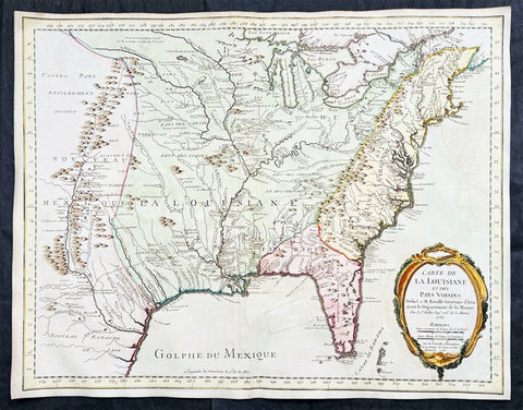
Jacques Nicolas Bellin

1744 Bellin & de Maurepas Large Antique Map North America Colonial United States
- Title : Carte De La Louisiane Cours Du Mississipi et Pais Voisins...N Bellin 1744
- Date : 1744
- Size: 23in x 16 1/4in (585mm x 415mm)
- Condition: (A) Very Good Condition
- Ref: 27094
Description:
This important, original hand coloured copper plate engraved antique map of North America and the colonial states by Nicolas Bellin in conjunction with Jean-Frédéric Phélypeaux, the Comte de Maurepas, was engraved and published in 1744, dated.
This detailed map depicts the region of Louisiana and the Mississippi River, as well as neighboring territories such as Florida, the Great Lakes, and the Gulf of Mexico. The map is richly decorated with a detailed cartouche featuring a Native American figure, various animals, and a scale bar.
The map is highly detailed and accurate, with the major waterways, coastlines, and settlements clearly marked. The topographical features such as mountains, forests, and swamps are also depicted in great detail. The map includes annotations in French, indicating the locations of various Native American tribes and European settlements.
One interesting feature of the map is the depiction of the river system, with numerous tributaries branching out from the Mississippi River. The map also includes illustrations of the mouth of the Mississippi River and various settlements along its banks.
Overall, Carte De La Louisiane Cours Du Mississipi et Pais Voisins is a beautiful and informative example of 18th-century cartography. Bellin's map reflects the geopolitical tensions of the era, as France and England were competing for control over the region, and it remains a valuable resource for historians and collectors alike.
General Definitions:
Paper thickness and quality: - Heavy and stable
Paper color : - off white
Age of map color: - Original
Colors used: - Yellow, green, blue, pink
General color appearance: - Authentic
Paper size: - 23in x 16 1/4in (585mm x 415mm)
Plate size: - 23in x 16 1/4in (585mm x 415mm)
Margins: - Min 1/2in (12mm)
Imperfections:
Margins: - Right margin extended from border
Plate area: - Folds as issued
Verso: - Folds as issued
Background:
The Comte de Maurepas and Nicolas Bellin were both influential figures in the French Navy during the 18th century, and they worked closely together on several important projects.
Jean-Frédéric Phélypeaux, the Comte de Maurepas, was a French statesman who served as Secretary of State for the Navy under Louis XV. He was a strong supporter of naval exploration and cartography, and he played a key role in promoting the work of cartographers such as Nicolas Bellin.
Nicolas Bellin, as mentioned earlier, was a French cartographer, hydrographer, and engineer who produced numerous maps and atlases that were highly regarded for their accuracy and detail. Bellin worked closely with the Comte de Maurepas on several projects, including the creation of the Neptune François, a collection of maps and nautical charts of the world's oceans.
The Neptune François was a major undertaking that involved the collaboration of numerous cartographers and hydrographers, including Bellin. The project was overseen by the Comte de Maurepas and was intended to provide French sailors with the most up-to-date and accurate information about the world's oceans.
Bellin's contributions to the Neptune François were extensive, and he was responsible for creating numerous maps and charts that covered a wide range of regions, including the Mediterranean, the Caribbean, and North America. His work on the project helped establish him as one of the leading cartographers of his time.
Overall, the Comte de Maurepas and Nicolas Bellin were both instrumental in advancing the field of cartography during the 18th century. Through their collaboration on projects such as the Neptune François, they helped to establish the French Navy as a leading authority on maritime exploration and mapping.
Please note all items auctioned are genuine, we do not sell reproductions. A Certificate of Authenticity (COA) can be issued on request.
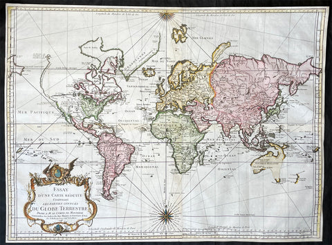
1748 J N Bellin Large Antique World Map on Mercators Projection
- Title : Essay d une Carte Reduite Contenant les parties connuees Du Globe Terrestre...1748
- Date : 1748
- Size: 25 3/4in x 19in (705mm x 480mm)
- Condition: (A) Very Good Condition
- Ref: 17011
Description:
This large original hand coloured copper-plate engraved 4 sheet joined, antique World Map on Mercators Projection was engraved in 1748 by Jacques Nicolas Bellin - dated in the title.
General Definitions:
Paper thickness and quality: - Heavy and stable
Paper color : - off white
Age of map color: - Later
Colors used: - Blue, yellow, green, pink
General color appearance: - Authentic
Paper size: - 25 3/4in x 19in (705mm x 480mm)
Plate size: - 25 3/4in x 19in (705mm x 480mm)
Margins: - Min 1/4in (5mm)
Imperfections:
Margins: - Margins extended from border
Plate area: - Light creasing
Verso: - Light creasing
Background:
First edition of Bellins large mid-18th century world map, published in Paris. This map pre-dates the major world discoveries of the late 18th century including the North West coast of America, the Sandwich Islands, and the Voyages of Capt Cook soon to map the East Coast of Australia & NZ.
This edition is most noteworthy for its marvelous early projection of Australia and New Zealand, each with largely speculative coastlines. Australia is still attached to New Guinea and has several notes of early exploration shown. New Zealand is barely known and with only a portion of its western coastline.
No sign of Antarctica and the NW Coast of America includes the first notes of Russian exploration.
In North America Bellin identifies the semi-mythical civilizations of Quivira and Teguayo, both associated with legends of the Seven Cities of Gold, in what is modern day Utah, California, and Nevada. Along the western coast the strait discovered by Martin Aguilar is noted. Further north still the River of the West (Fl. de l’Ouest) extends from the west coast to the Lake of the Woods (Lac de Bois) and thence via additional waterways to the Great Lakes and the Atlantic. The River of the West appeared in many 18th century maps of the Americas and is reflective of French hopes for a water route from their colonies in Canada and Louisiana to the Pacific. Still further north the coastline becomes extremely vague, in places vanishing altogether. The Aleutians are vaguely rendered according to various sightings by Vitus Jonassen Bering and Aleksei Chirikov in the 1740s and identified as the “Archipel de Nord”.
In the Pacific, various Polynesian Island groups are noted though many are slightly or significantly misplaced. The Solomon Islands are vastly oversized referencing the early 17th claims of Quiros. The other lands discovered and erroneously mapped by Quiros in 1606 and Davis in 1686 during their search of the great southern continent are also noted. Hawaii, as yet undiscovered, is absent. New Zealand is rendered twice though is accurate in its form and position. Australia, here labelled “Nouvelle Holland”, has part of its southern coastline ghosted in and Van Diemen’s Land (Tasmania) is attached to the mainland. The southern coast of New Guinea is similarly ghosted in, suggesting its unexplored state. (Ref: Tooley; M&B)
1748 J N Bellin Large Antique World Map on Mercators Projection - 27007
- Title : Essay d une Carte Reduite Contenant les parties connuees Du Globe Terrestre...1748
- Date : 1748
- Size: 28 1/2in x 21in (725mm x 535mm)
- Condition: (A) Very Good Condition
- Ref: 27007
Description:
This large original hand coloured copper-plate engraved antique World Map, on Mercators Projection was engraved in 1748 by Jacques Nicolas Bellin - dated in the title.
General Definitions:
Paper thickness and quality: - Heavy and stable
Paper color : - off white
Age of map color: - Early
Colors used: - Blue, yellow, green, pink
General color appearance: - Authentic
Paper size: - 28 1/2in x 21in (725mm x 535mm)
Plate size: - 26in x 20 1/2in (710mm x 520mm)
Margins: - Min 1/4in (5mm)
Imperfections:
Margins: - Bottom left margin extended from plate -mark
Plate area: - Folds as issued
Verso: - Folds as issued
Background:
First edition of Bellins large mid-18th century world map, published in Paris. This map pre-dates the major world discoveries of the late 18th century including the North West coast of America, the Sandwich Islands, and the Voyages of Capt Cook soon to map the East Coast of Australia & NZ.
This edition is most noteworthy for its marvelous early projection of Australia and New Zealand, each with largely speculative coastlines. Australia is still attached to New Guinea and has several notes of early exploration shown. New Zealand is barely known and with only a portion of its western coastline.
No sign of Antarctica and the NW Coast of America includes the first notes of Russian exploration.
In North America Bellin identifies the semi-mythical civilizations of Quivira and Teguayo, both associated with legends of the Seven Cities of Gold, in what is modern day Utah, California, and Nevada. Along the western coast the strait discovered by Martin Aguilar is noted. Further north still the River of the West (Fl. de l’Ouest) extends from the west coast to the Lake of the Woods (Lac de Bois) and thence via additional waterways to the Great Lakes and the Atlantic. The River of the West appeared in many 18th century maps of the Americas and is reflective of French hopes for a water route from their colonies in Canada and Louisiana to the Pacific. Still further north the coastline becomes extremely vague, in places vanishing altogether. The Aleutians are vaguely rendered according to various sightings by Vitus Jonassen Bering and Aleksei Chirikov in the 1740s and identified as the “Archipel de Nord”.
In the Pacific, various Polynesian Island groups are noted though many are slightly or significantly misplaced. The Solomon Islands are vastly oversized referencing the early 17th claims of Quiros. The other lands discovered and erroneously mapped by Quiros in 1606 and Davis in 1686 during their search of the great southern continent are also noted. Hawaii, as yet undiscovered, is absent. New Zealand is rendered twice though is accurate in its form and position. Australia, here labelled “Nouvelle Holland”, has part of its southern coastline ghosted in and Van Diemen’s Land (Tasmania) is attached to the mainland. The southern coast of New Guinea is similarly ghosted in, suggesting its unexplored state. (Ref: Tooley; M&B)
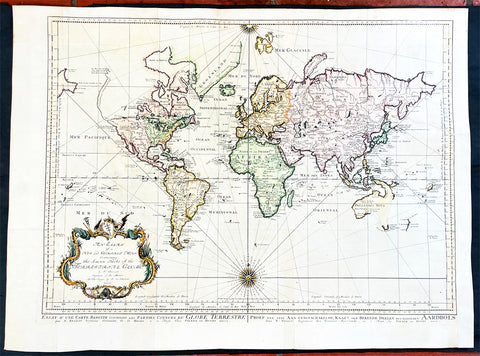
1750 (1755) Nicolas Bellin Very Scarce Large Antique Map of North America
- Title : Carte de La Louisiane et Des Pays Voisins Dediee a M. Rouille Secretairr 'd Etat ayant le Departement de la Marine . . . 1750 . . . Sur de Nouvelle Observations on a corrigee les Lacs, et leurs Enviorns. 1755.
- Date : 1750 (1755)
- Size: 25in x 19 1/2in (635mm x 495mm)
- Condition: (A) Very Good Condition
- Ref: 35661
Description:
This large original very scarce hand coloured copper-plate engraved antique map of North America by Nicolas Bellin, in 1750 - dated - and updated in 1755, was published as a single map by Nicolas Bellin in Paris.
Extremely important, large and scarce 1755 map of North America issued at the outbreak of the French and Indian War (1754 - 1763). Centered on the vast Mississippi Valley, the map covers from the Rio Grande to the Atlantic Seaboard and from Lake Superior to the Florida Keys. While first issued in 1750, the present map has been updated considerably to represent French, English, and Spanish claims at the outbreak of the French and Indian War. Most of the most important battle sites are forts are noted, including Fort Duquesne, Fort Necessity, Fr. Le Boeuf, Fort Presqu'Isle, and Fort St. Frederic, among others.
General Definitions:
Paper thickness and quality: - Heavy and stable
Paper color : - off white
Age of map color: - Early & later
Colors used: - Green, yellow, pink
General color appearance: - Authentic
Paper size: - 25in x 19 1/2in (635mm x 495mm)
Plate size: - 25in x 19 1/2in (635mm x 495mm)
Margins: - Min 1/2in (12mm)
Imperfections:
Margins: - None
Plate area: - Small professional restoration in GOM
Verso: - None
Background:
The map presents the much of the modern United States as the French understood it at the outbreak of the war. Spanish territory is red, English territory is yellow, and French territory is green. The British are here restricted to the coastal lands east of the Appalachian Mountains, and bounded on the south by the Altamaha River, which forms the boundary with Spanish Florida. French Territorial claims are expansive, encompassing roughly 2/3rds of the land and controlling the most valuable waterways, including the Great Lakes, the Ohio, and the Mississippi. Forts, mission settlements, mines, and trading posts dot the Mississippi Valley, but in truth, most of these were, by this time, only loosely manned or altogether abandoned - hardly an argument for effective occupation.
This map features a wealth of cartographic information drawn in part from the Guilaume de L'Isle map of 1718, but has been expanded considerably with new information from the the Chaussegros de Lery manuscripts and Pierre-Francois-Xavier de Charlevoix s Histoire et description generale de la Nouvelle France. Of note is the curious mountain range running through Michigan.
The inclusion of Fort Necessity is significant, as it suggests this map was issued just months after the construction of the fort and George Washington's disastrous defeat there. It underscores how quickly information moved - even through the outback of the New World and active war. For this map to have been made, news of the events, as well as cartographic reconnaissance, would have had to move rapidly from Fort Duquesne, down the Ohio River, then down the full length of the Mississippi, then across the Atlantic to Paris. There Bellin would have had to study the work, reconcile it with his older maps, update and re-engrave them accordingly, and then get the map to the presses for distribution. The whole is a remarkable accomplishment, but may explain somewhat this maps scarcity, as in a short time, much of the data he would be irreverent.
The map is dedicated to Antoine-Louis Rouillé, comte de Jouy (1689 - 1761). Rouillé replaced Jean-Frédéric Phélypeaux, 1st Count of Maurepas (1701 - 1781), Bellin's former patron, as Secretary of State for the Navy (Ministère de la Marine) on July 24, 1754, just in time for the French and Indian War. Bellin, who worked under the Navy Department, would have been highly motivated to engender Rouillé patronage and good well, making the dedication unsurprising.
The map was separately published in Paris, France by Jacques-Nicolas Bellin. It is dedicated to M. Rouillé. It represents the second state of the map, 1755, issued during the French and Indian War. Examples are extremely scarce. We have identified only three examples, including this map, in the last 20 years of market history. The map is further not identified in Cumming, Karpinski, Ehrenberg, or Phillips. The OCLC notes examples in 8 institutions, but upon closer inspection many of these appear to be digital resources and do not represent any actual holdings.
Please note all items auctioned are genuine, we do not sell reproductions. A Certificate of Authenticity (COA) can be issued on request.
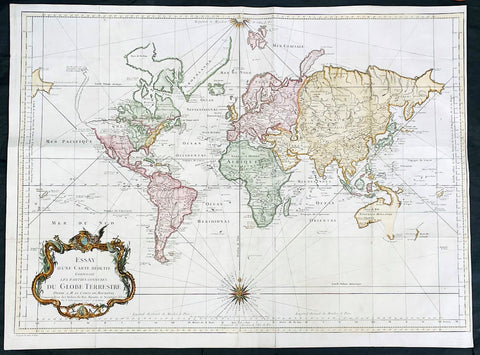
1750 J N Bellin Large Antique World Map on Mercators Projection - 27091
- Title : An Essay of a New and Complet Map Containing the Known Part of the Terrestial Globe by N Bellin....MDDCL
- Date : 1750
- Size: 30 1/2in x 22 1/2in (825mm x 570mm)
- Condition: (A) Very Good Condition
- Ref: 27091
Description:
This large original hand coloured copper-plate engraved antique World Map, on Mercators Projection by Jacques Nicolas Bellin was engraved by Jacobus van der Schley in 1750 - dated in the title - and was published in Dutch/English by Pierre d Hondt, publisher, operated out of the Hague.
General Definitions:
Paper thickness and quality: - Heavy and stable
Paper color : - off white
Age of map color: - Early
Colors used: - Blue, yellow, green, pink
General color appearance: - Authentic
Paper size: - 30 1/2in x 22 1/2in (825mm x 570mm)
Plate size: - 27 1/2in x 20 1/2in (700mm x 520mm)
Margins: - Min 1in (25mm)
Imperfections:
Margins: - Bottom left margin extended from plate -mark
Plate area: - Folds as issued
Verso: - Folds as issued
Background:
First edition of Bellins large mid-18th century world map, published in Paris. This map pre-dates the major world discoveries of the late 18th century including the North West coast of America, the Sandwich Islands, and the Voyages of Capt Cook soon to map the East Coast of Australia & NZ.
This edition is most noteworthy for its marvelous early projection of Australia and New Zealand, each with largely speculative coastlines. Australia is still attached to New Guinea and has several notes of early exploration shown. New Zealand is barely known and with only a portion of its western coastline.
No sign of Antarctica and the NW Coast of America includes the first notes of Russian exploration.
In North America Bellin identifies the semi-mythical civilizations of Quivira and Teguayo, both associated with legends of the Seven Cities of Gold, in what is modern day Utah, California, and Nevada. Along the western coast the strait discovered by Martin Aguilar is noted. Further north still the River of the West (Fl. de l’Ouest) extends from the west coast to the Lake of the Woods (Lac de Bois) and thence via additional waterways to the Great Lakes and the Atlantic. The River of the West appeared in many 18th century maps of the Americas and is reflective of French hopes for a water route from their colonies in Canada and Louisiana to the Pacific. Still further north the coastline becomes extremely vague, in places vanishing altogether. The Aleutians are vaguely rendered according to various sightings by Vitus Jonassen Bering and Aleksei Chirikov in the 1740s and identified as the “Archipel de Nord”.
In the Pacific, various Polynesian Island groups are noted though many are slightly or significantly misplaced. The Solomon Islands are vastly oversized referencing the early 17th claims of Quiros. The other lands discovered and erroneously mapped by Quiros in 1606 and Davis in 1686 during their search of the great southern continent are also noted. Hawaii, as yet undiscovered, is absent. New Zealand is rendered twice though is accurate in its form and position. Australia, here labelled “Nouvelle Holland”, has part of its southern coastline ghosted in and Van Diemen’s Land (Tasmania) is attached to the mainland. The southern coast of New Guinea is similarly ghosted in, suggesting its unexplored state. (Ref: Tooley; M&B)