Friedrich Arnold Friedrich Arnold
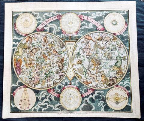
1720 Homann, Doppelmayr & Eimmart Antique Twin Hemisphere Celestial Chart, Map. Planisphaerium Caeleste
- Title : Planisphaerium Caeleste
- Ref #: 27010
-
Condition: (A+) Fine Condition
- Size: 25in x 21 1/2in (635m x 545mm)
- Date : 1720
- Price: $2750.00US
Description:
This magnificent original hand coloured copper plate engraved antique double hemisphere celestial chart, showing constellations of the northern and southern hemispheres depicted as allegorical figures, animals and scientific instruments after Georg Christoph Eimmart (1638-1705) was published by Johann Baptist Homann and Johann Gabriel Doppelmayr (1677-1750) in ca 1720.
The stars are shown in six degrees of magnitude according to a key in the center between the hemispheres. The selection and style of the constellations followed that of Firmamentum Sociescianum sive Uranographia (1687) by the Polish astronomer Johannes Hevelius, whose name is noted in the subtitle of the chart. The subtitle further indicates that the chart also draws on the work of Edmund Halley, the British astronomer for whom Halley’s Comet is named. There are numerous variants of this chart published in Germany in the 18th century; this example, Planispaerium Caeleste by Homann, bears the name of the firm (Officina Homanniana) under the border in the lower margin, together with the name of Georg Christoph Eimmart (1638-1705), the Nuremberg astronomer.
General Definitions:
Paper thickness and quality: - Heavy and stable
Paper color : - off white
Age of map color: - Original
Colors used: - Yellow, green, blue, pink
General color appearance: - Authentic
Paper size: - 25in x 21 1/2in (635m x 545mm)
Plate size: - 23in x 19 1/2in (585mm x 495mm)
Margins: - Min 1/2in (12mm)
Imperfections:
Margins: - None
Plate area: - None
Verso: - None
Background:
The outer borders of the chart are decorated with six inset diagrams against a background of clouds including the planetary models of Tycho Brahe, Ptolemy, and Copernicus. The other 3 diagrams show the illumination of the moon by the sun, the revolution of the earth around the sun, and the effect of the moon on tides.
Various firms in Amsterdam, Nuremberg and Augsburg published double hemisphere constellation charts based on the work of George Eimmart titled Planispaerium Caeleste or Planisphaerium Coeleste during the first eight decades of the 18th century, which can be divided fundamentally into two different versions. The prolific Nuremberg publisher Johann Baptist Homann first published Planispaerium Caeleste in his Neuer Atlas in 1707, bearing the inscription Opera G.C. Eimmarti. prostat in Officina Homanniana, meaning Work of Georg Christoph Eimmart offered for sale by the Homann Workshop. That chart has six inset diagrams. Scholar Robert H. van Gent notes the existence of similar prints of this format published by de Wit, Funck, Schenck, and Lotter, as well as by R. & J. Ottens in Amsterdam. The other versions vary more considerably with the inclusion of a seventh inset diagram and a figural illustration in the upper center. These include ones published by Melchior Rein in Augsburg and by Georg Matthäus Seutter (1647–1756) in Nuremberg.
Johann Gabriel Doppelmayr and Johann Baptist Homann were frequent collaborators in producing celestial and astronomical charts for atlases published by Homann and issued under various titles. The major two compilations of Dopplemayr’s works were published by Homann Heirs: Atlas Coelestis in quo Mundus Spectabilis et in Eodem Stellarum Omnium Phoenomena Notabilia, issued as 30 plates in 1742, and the revised edition of this work Atlas Novus Coelestis, in quo Mundus Spectabilis, et in Eodem tam Errantium quam Inerrantium Stellarum Phoenomena Notabilia, issued in 1748 (with an additional plate depicting the solar eclipse of 1748).
Nonetheless, these charts have a complicated publishing history that is not fully known. Some of these charts had appeared in earlier Homann editions such as his first atlas, the Neuer Atlas (Nuremberg: 1707), Atlas von Hundert Charten (Nuremberg: 1712), Grossen Atlas (Nuremberg: 1716), and Atlas Portatilis Coelestis (Nuremberg: 1723). Homann also issued geographical maps in various atlases that may have included celestial plates (particularly composite atlases), and Homann and his heirs presumably sold separately issued maps. Further, three additional celestial and astronomy plates have been located in at least one Homann celestial compilation atlas (1742, 1748, or later), though not among the 30 maps of the standard issue of Atlas Coelestis in quo Mundus Spectabilis, namely Sphaerarum Artificialium Typica Repraesentatio (globes and armillary sphere), Neu invertirte Geographische Universal (clock), and Planisphaerium Caeleste (double hemisphere celestial chart).
Doppelmayr, a professor of mathematics at the Aegidien Gymnasium at Nuremberg, was an acclaimed German geographer and astronomer who wrote on astronomy, geography, cartography, trigonometry, sundials and mathematical instruments. He was also involved in the production of globes as part of a larger goal to bring the scientific ideas of the Enlightenment to a broader public. In service of that idea, Doppelmayr translated several works into German including Nicholas Bion’s 1699 work L’usage des globes célestes et terrestes, et des sphères [The Usage of Celestial and Terrestrial Globes and of Spheres]. Doppelmayr was elected to several scientific societies, including the Berlin Academy of Sciences, the Royal Society and the St. Petersburg Academy of Sciences.
Please note all items auctioned are genuine, we do not sell reproductions. A Certificate of Authenticity (COA) can be issued on request.
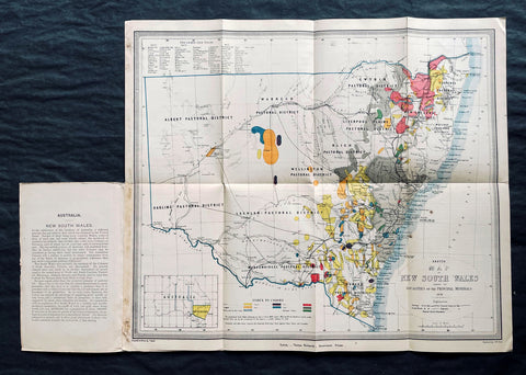
1876 Thomas & Tayler Scarce Antique Goldfields & Minerals Map of New South Wales
- Title : Sketch Map of New South Wales showing the Localities of the Principal Minerals 1876
- Ref #: 27011
-
Condition: (A+) Fine Condition
- Size: 18in x 15 1/2in (455mm x 400mm)
- Date : 1876
Description:
This original, incredibly scarce & important, antique lithograph map of New South Wales, illustrating the location of the Principle Minerals of that state, was drawn by John Tayler, engraved by G W Sharp and published by Thomas Richards in 1876 - dated, Sydney
General Definitions:
Paper thickness and quality: - Heavy and stable
Paper color : - off white
Age of map color: - Original
Colors used: - Yellow, green, blue, pink
General color appearance: - Authentic
Paper size: - 18in x 15 1/2in (455mm x 400mm)
Plate size: - 18in x 15 1/2in (455mm x 400mm)
Margins: - Min 1/2in (12mm)
Imperfections:
Margins: - Folds as issued
Plate area: - Folds as issued
Verso: - Folds as issued
Background:
The map shows New South Wales' new (and current) boundaries, with the state's 'Pastoral Districts' delineated; railways from Ports Hunter and Jackson are shown, along with their proposed extensions inland. Roads and telegraph lines are also indicated. Relief is shown by hachure. An inset map in the lower left shows the state's location on the Australian continent. These features are shared by the authors' other maps of New South Wales, the 1871 Map of New South Wales and the 1878 Sketch map of New South Wales showing the principal agricultural districts. Specific to this map, areas printed in color show the regions understood to be rich in minerals: Kerosene shale, coal, tin, iron, silver, copper, gold and 'diamonds and other gems.' The data on the map reflects the experience of some twenty years of prospecting in New South Wales, but predate the first systematic geological survey of the state, which would not be completed until 1880. The map specifies that the gold fields are 'proclaimed' gold fields, that is to say, permissible for prospectors. No prospector's claim was valid unless it fell within the limits of a 'proclaimed' field, which was officially recognized by the state and administered by a commissioner. The earlier 1873 edition of this map distinguishes between 'proclaimed' and 'unproclaimed' fields; in the present edition, the 'unproclaimed' fields have disappeared entirely. By 1876, control of gold mining in the state had passed from the Department of Lands to a new administration, the Department of Mines; in conjunction with this, mining had become less of a prospector-driven, 'gold rush' affair and more the province of mining companies employing more sophisticated processes, capable of extracting wealth from existing claims in which lower-capitalized operations were ineffective.
John Tayler 1861 - 1875 was an Australian cartographer and draftsman, employed by the NSW Surveyor Generals Office. His 1871 Map of New South Wales appears to have provided the basis for the bulk of the maps of the state produced prior to the Geological survey of 1880.
Richards, Thomas (1831 - 1898)
Thomas Richards, government printer, was born on 21 December 1831 in Pitt Street, Sydney, son of James Richards, builder, and his wife Mary, née OBrien. He was baptized a Catholic. His parents died in his infancy and he was reared by his aunt, the daughter of a sergeant-major in the First Fleet, and educated at Ebenezer on the Hawkesbury River. Having answered an advertisement for an intelligent youth, on 1 January 1845 he was engaged as an apprentice in the Government Printing Office, where he advanced as clerk, proof-reader, compositor, pressman, overseer and, in 1854, superintendent. In June 1859 he became government printer and inspector of stamps at a salary of £500, which had been reduced from his predecessors £850, but was raised to £600 in 1863; he had a staff of seventy. As he lacked London experience his appointment was unpopular. From 1 July 1879 he was also registrar of copyright.
During Richardss innovative administration, with increasing volume of work, the office expanded its functions and techniques. In 1863 he introduced photo-lithography and, after he had observed plant in Victoria in 1864, he added stereo-typing and electro-typing. In 1868 following the establishment of extra branches a new fast process of photo-lithography was invented by John Sharkey whose experiments were encouraged and assisted by Richards. The Sydney Morning Herald praised the gems of photo-lithographic art the Printing Office displayed at the 1870 Intercolonial Exhibition at Sydney. Later Richards initiated helio-type or photo-mechanical printing, introduced a perforating machine and invented a method of drying stamps with heat from gas. He devised an arithmotype bars system for numbering debentures which was adopted in all the colonies and England; he alleged the Bank of England took the patent without acknowledgment.
Frequently working long hours, Richards was criticized by some politicians for his administration and his publication of documents of allegedly limited public interest. He defended himself adequately before the 1870 select committee on the Government Printing Office, resisting suggestions of reductions in salaries and praising his men for the finest examples of the modern technique of photo-lithography seen in the colonies; and he admitted ambitions to produce an Australian geography and natural history, a year-book and dictionary of names for New South Wales. Looking back in 1891 he wrote, I had opposed to me a truculent minister, a truculent under-secretary and a truculent newspaper proprietor … I beat them but came out of the fray wounded in mind body and estate. He also had trouble with trade unions in difficult industrial times for heads of government departments and in 1875 antagonized the Trades and Labor Council by threatening to close the Office against all union men.
In 1877 Richards represented the government on an English committee to celebrate the quatercentenary of Caxtons introduction of printing. With twelve months leave he also studied advanced methods and bought new machinery. At the 1878 Paris Universal Exhibition he won a silver and two bronze medals and at the 1880 Melbourne International Exhibition he won five high diplomas for printing, bookbinding and photography. The 1883 Amsterdam Exhibition awarded him a gold and a silver medal, and the Printing Office was commended at other important exhibitions from 1862 to 1886. In 1882 Richards compiled, edited and printed the highly regarded New South Wales in 1881, which was translated into French; next year the office produced An Epitome of the Official History of New South Wales.
On 23 April 1861 Richards had joined the Volunteer Rifles as a second lieutenant. A good shot and member of the New South Wales Rifle Association, in 1885 he became lieutenant-colonel of the first regiment, Volunteer Infantry; he resigned next year. In November 1886, because of rapidly failing eyesight, Richards retired as government printer on a pension of £480; he left a staff of 400 and an office with sixty-one new departments. On 31 August 1898 he died at Manly and was buried in the Anglican cemetery there. On 29 January 1865, with Anglican rites, he had married Zara Bell, by whom he had three daughters and two sons who survived him.
Please note all items auctioned are genuine, we do not sell reproductions. A Certificate of Authenticity (COA) can be issued on request.
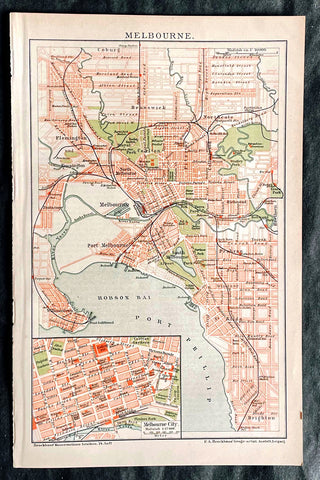
1896 F.A. Brockhaus Antique Map, Street Plan of Melbourne, Victoria, Australia
- Title : Melbourne
- Ref #: 27012
-
Condition: (A+) Fine Condition
- Size: 10in x 6 1/2in (255mm x 165mm)
- Date : 1896
Description:
This original antique lithograph street map of Melbourne Australia was engraved and published F.A. Brockhaus for the Brockhaus Konversations Lexikon, Germany, 1896
General Definitions:
Paper thickness and quality: - Heavy and stable
Paper color : - off white
Age of map color: - Original
Colors used: - Yellow, green, blue, pink
General color appearance: - Authentic
Paper size: - 10in x 6 1/2in (255mm x 165mm)
Plate size: - 10in x 6 1/2in (255mm x 165mm)
Margins: - Min 1/2in (12mm)
Imperfections:
Margins: - None
Plate area: - None
Verso: - None
Brockhaus, Friedrich Arnold (1772 - 1823)
Friedrich Arnold Brockhaus was a German encyclopedia publisher and editor, famed for publishing the Conversations-Lexikon, which is now published as the Brockhaus encyclopedia.
Brockhaus was educated at the gymnasium of his native Dortmund, and from 1788 to 1793 served an apprenticeship in a mercantile house at Düsseldorf. He then devoted two years at the University of Leipzig to the study of modern languages and literature, after which he set up in Dortmund an emporium for English goods. In 1801, he transferred this business to Arnheim, and in the following year to Amsterdam.
In 1805, having given up his first line of trade, Brockhaus began business as a publisher. Two journals projected by him were not allowed by the government to survive for any length of time, and in 1810 the complications in the affairs of Holland induced him to return homewards. In 1811 he settled at Altenburg. About three years previously he had purchased the copyright of the bankrupt Conversations-Lexikon, an encyclopedia started in 1796, and in 1810-1811 he completed the first edition of this celebrated work. It was widely imitated as a model for encyclopedias, and is still published today, known as the Brockhaus Encyclopedia.
A second edition under Brockhauss editorship was begun in 1812, and was received with universal favour. His business extended rapidly, and in 1818 Brockhaus moved to Leipzig, where he established a large printing-house. Among the more extensive of his many literary undertakings were the critical periodicals — Hermes, the Literarisches Konversationsblatt (afterwards the Blätter für literarische Unterhaltung) and the Zeilgenossen, and some large historical and bibliographical works, such as Friedrich Ludwig Georg von Raumers Geschichte der Hohenstaufen, and Friedrich Adolf Eberts Allgemeines bibliographisches Lexikon.
Brockhaus died in Leipzig. The business was carried on by his sons, Friedrich Brockhaus (1800–1865), who retired in 1850, and Heinrich Brockhaus (1804–1874), under whom it was considerably extended. Heinrich especially rendered great services to literature and science, which the University of Jena recognized by making him, in 1858, honorary Doctor of Philosophy. In the years 1842–1848, Heinrich Brockhaus was member of the Saxon second chamber, as representative for Leipzig, was made honorary citizen of that city in 1872, and died there on 15 November 1874.
His firm continues under the name F.A. Brockhaus AG in his honor. He is also the namesake of 27765 Brockhaus, a main-belt asteroid discovered in 1991.
Please note all items auctioned are genuine, we do not sell reproductions. A Certificate of Authenticity (COA) can be issued on request.