D T Valentine
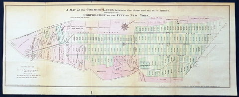
1796 Large Antique Map of New York City by DT Valentine Published in 1861
- Title : A Map of the Common Lands between the three and six mile stones belonging to the Corporation of the City of New York March 5th 1796....Lith for DT Valentine Manual for 1861 by Geo. Hayward.
- Size: 20in x 8in (510mm x 200mm)
- Condition: (A+) Fine Condition
- Date : 1861
- Ref #: 93132
Description:
This original hand coloured antique lithograph map of common lands in New York City in 1796, by George Hayward was published in the 1861 edition of D T Valentines Manual of the Corporation of the City of New York or Valentines Manual.
The map illustrates New York city Common Lands in 1796, between the three and six mile stones belonging to the Corporation of the City of New York.
The map begins south of Harlem, showing numbered plots of common lands as well as areas of ownership, with owners names. Here 5th Ave is named Middle Road, East Road became 4th Ave which is now Park Ave. The map goes as far north as 90th st and as far south as Madison Square Park, which was a burying ground in the late 1700s. Broadway is named Bloomingdale Rd.
General Definitions:
Paper thickness and quality: - Light and stable
Paper color : - off white
Age of map color: - Original
Colors used: - Yellow, green, blue, pink
General color appearance: - Authentic
Paper size: - 20in x 8in (510mm x 200mm)
Plate size: - 20in x 8in (510mm x 200mm)
Margins: - Min 1/2in (12mm)
Imperfections:
Margins: - Light age toning
Plate area: - Folds as issued
Verso: - Folds re-enforced with archival transparent tape
Background:
Manual of the Corporation of the City of New Yorkor Valentines Manuals, published for nearly 30 years, contained hundreds of rare beautifully hand coloured contemporary and historical lithograph maps and views of New York City.
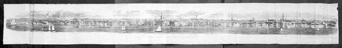
1798 Hayward Very Long View of New York City from Brooklyn, Pub. Valentine 1861
- Title : A View of the City of New York from Brooklyn Heights, foot of Pierrepont St. in 1798 by Monsieur C. B. Julien, de St. Memin with a Pantograph invented by himself
- Date : 1861
- Condition: (A) Very Good Condition
- Ref: 93131
- Size: 55in x 7in (1.40m x 180mm)
Description:
This long (55in) original antique rare lithograph print, a view of New York City, from Brooklyn Heights, in 1798 by George Hayward was published in the 1861 edition of D T Valentines Manual of the Corporation of the City of New York or Valentines Manual.
A rare highly detailed and almost photograph like view of New York City, with names of houses and significant places recorded is one of the earliest real life views available as it was at the end of the 18th century. Included in the view is Trinity Church, Wall St., St. Paul\'s Church, the New York Hospital and many other early building of NYC.
General Definitions:
Paper thickness and quality: - Light and stable
Paper color : - off white
Age of map color: -
Colors used: -
General color appearance: -
Paper size: - 55in x 7in (1.40m x 180mm)
Plate size: - 55in x 7in (1.40m x 180mm)
Margins: - Min 1/2in (12mm)
Imperfections:
Margins: - Light chipping along edges
Plate area: - Folds as issued, light creasing, repair to first left fold
Verso: - Folds as issued, light creasing, repair to first left fold
Background:
Manual of the Corporation of the City of New York or Valentines Manuals, published annually for nearly 30 years, contained hundreds of rare beautifully hand coloured contemporary and historical lithograph maps and views of New York City.
Valentine, David Thomas 1801 - 1869
As the Clerk of the Common Council of New York City, Valentine edited and published a series of books on the history and contemporary facts of New York City entitled Manual of the Corporation Of The City of New York. They became know as Valentines Manuals with updates published annually, between 1841 & 1870. Valentine used his manuals to produce some of the rarest and most important maps & views of the city of New York, some of which occasionally appear on the market. His contribution to the historical record of New York city cannot be over stated.
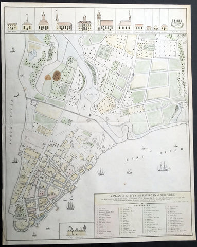
1854 (1813) Valentine, Grimm Large Old, Antique Map of New York City in 1742
- Title : A Plan of the City and Environs of New York as they were in the Years 1742 - 1743 and 1744. Drawn by D... G...in the 76th year of his age who had at this time a perfect & correct recollection of every part of the same
- Ref #: 35102
- Size: 23 1/2in x 18 1/2in (600mm x 470mm)
- Date : 1854 (1813)
- Condition: (A+) Fine Condition
Description:
This hand coloured original, antique highly detailed map* of New York City in the 1740's by David Grimm in 1813, was engraved by George Hayward in 1854 - dated in title - and was presented to the New York Historical Society edition of D. T. Valentine's Manual in 1854.
The map features a reference chart of governmental, religious and public buildings, as well as as rivers, farms and wells. Also includes ships sailing in the north and East river. The top of the map are illustrations of religious houses and building and at the bottom of the map is a illustration of Fort George.
Illustration of this map can be found at the New York City Library.
http://digitalcollections.nypl.org/items/2af29660-0f61-0132-6b5f-58d385a7b928 (Ref: M&B; Tooley)
General Description:
Paper thickness and quality: - Light & stable
Paper color: - White
Age of map color: - Original
Colors used: - Yellow, red, green, blue
General color appearance: - Authentic
Paper size: - 23 1/2in x 18 1/2in (600mm x 470mm)
Paper size: - 23 1/2in x 18 1/2in (600mm x 470mm)
Margins: - Min 1/2in (12mm)
Imperfections:
Margins: - Light age toning
Plate area: - Light age toning, brown stain top left corner of map
Verso: - Light age toning