
Augustus Heinrich Petermann
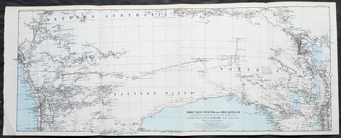
1876 Petermann Antique Map Expedition Ernest Giles Western & South Australia, 1875
- Title : Thomas Elders Expedition durch Inner-Australien vom Beltana im Osten bis Perth im Westen, Ausgefuhrt Durch E. Giles Mai - Nov 1875
- Size: 27in x 11in (285mm x 280mm)
- Condition: (A+) Fine Condition
- Date : 1876
- Ref #: 82054
Description:
This early folding original antique lithograph map of Western & South Australia - from Perth to Lake Torrens South Australia covering the 3rd & 4th expedition of the explorer Ernest Giles in 1875 by Augustus Heinrich Petermann was engraved in 1877 - dated - and was published by Justus Perthes, Gotha Germany.
General Definitions:
Paper thickness and quality: - Heavy and stable
Paper color : - off white
Age of map color: - Original
Colors used: - Blue, red, yellow
General color appearance: - Authentic
Paper size: - 27in x 11in (285mm x 280mm)
Plate size: - 27in x 11in (285mm x 280mm)
Margins: - Min 1/2in (12mm)
Imperfections:
Margins: - None
Plate area: - Folds as issued
Verso: - None
Background:
William Ernest Powell Giles 1835 – 1897 best known as Ernest Giles, was an Australian explorer who led five major expeditions in central Australia.
Giles did not attempt an organised expedition until 1872, when with two other men he left Chambers Pillar, South Australia (now in the Northern Territory), on 22 August and traversed much previously untrodden country to the north-west and west. Finding their way barred by Lake Amadeus and that their horses were getting very weak, a return was made to the Finke River and then to Charlotte Waters and Adelaide, where Giles arrived in January 1873. Giles looked upon his expedition as a failure, but he had done well considering the size and equipment of his party.
Giles friend Baron von Mueller raised a subscription so that a new expedition could be made. The services of William Tietkens as first assistant were obtained, and with two other men a start was made on 4 August 1873. The journey began considerably south from the previous expedition and from the Alberga River a generally western course was traversed. A month later in the Musgrave Ranges a fine running river was found and named the Ferdinand and by 3 October 1873 the party was approaching longitude 128 East. The country was extremely dry and though tested in various directions it was a constant struggle to get enough water to keep the horses going. Early in November, having passed longitude 126, a partial return was made and on 20 December 1873 the neighbourhood of Mount Scott was reached. A turn to the north and then west was made and the farthest westerly point was reached on 23 April 1874. Giles and one of the men, Alfred Gibson, had been scouting ahead when the latter\'s horse died. Giles gave him his own horse with instructions to follow their tracks back and obtain assistance. Giles made his way back to their depot on foot in eight days, almost completely exhausted, to find that Gibson had not reached the camp. A search was made for him for several days without success. The stores were almost finished, nothing further could be done, and on 21 May 1874 the return journey began. Giles named the desert Gibson Desert after his companion. On 24 June 1874 they were on a good track to the Finke River and on 13 July 1874 Charlotte Waters was reached. Giles had again failed to cross the continent, but in the circumstances all had been done that was possible.
Giles was the first European to see the rock formations of The Olgas, now known by their Aboriginal name of Kata Tjuta, and Lake Amadeus. He had wanted to name these Mt Mueller and Lake Ferdinand respectively, to honour his benefactor Baron Ferdinand von Mueller, however Mueller prevailed on him to instead honour the King Amadeus of Spain and Queen Olga of Württemberg. Giles supposedly discovered Uluru (formerly Ayers Rock), but was beaten to the claim by a competing explorer, William Gosse.
Early in 1875 Giles prepared his diaries for publication under the title Geographic Travels in Central Australia, and on 13 March 1875, with the generous help of Sir Thomas Elder, he began his third expedition. Proceeding considerably to the north from Fowler\'s Bay the country was found to be very dry. Retracing his steps Giles turned east, and eventually going round the north side of Lake Torrens reached Elder\'s station at Beltana. There the preparations for his fourth journey were made, and with Tietkens again his lieutenant, and with what Giles had always wanted, a caravan of camels, a start was made on 6 May. Port Augusta was reached on 23 May and, after taking a northerly course to clear the lakes, a generally westerly course was followed. Some water was carried, and the party was saved the continual excursions in search of water for horses that had caused so much difficulty during previous expeditions. Towards the end of September over 323 miles (520 km) had been covered in 17 days without finding water, when on 25 September the native Tommy found an abundant supply in a small hollow between sand dunes at Queen Victoria Spring, and the party was saved. After a rest of nine days the journey was resumed on 6 October the course being still west. Ten days later the expedition was attacked by a large body of aborigines and Giles was compelled to fire on them. On 4 November they met a white stockman at Tootra out-camp, east of Bindi Bindi. Their course was west to Walebing Station, then south-west and on 11 November they arrived at New Norcia where they were welcomed by Bishop Salvado. On 17 November 1875 the party arrived at Guildford and Perth the next day, where they received an enthusiastic reception.
Giles stayed for two months at Perth. Tietkens and Jess Young, another member of the expedition, went back to Adelaide by sea, and on 13 January 1876 Giles began the return journey taking a course generally about 400 miles north of the last journey. He arrived at Adelaide in September 1876 after a good journey during which the camels were found to be invaluable.
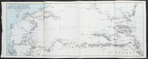
1876 Petermann Antique Map Western & South Australia - Warburton, Giles, Forrest
- Title : Die Neuesten Entdeckungsreisen im Inner-Australien von Warburton, Giles, Forrest, April 1873 - Sept 1874
- Size: 27in x 11in (285mm x 280mm)
- Condition: (A+) Fine Condition
- Date : 1876
- Ref #: 82055
Description:
This early folding original antique lithograph map of Western & South Australia and Alexandria land (Northern Territory) with the tracks of 3 explorers - in 1873 & 1874 - Peter Egerton-Warburton, Ernest Giles & Alexander Forrest by Augustus Heinrich Petermann was engraved in 1876 - dated - and was published by Justus Perthes, Gotha Germany.
General Definitions:
Paper thickness and quality: - Heavy and stable
Paper color : - off white
Age of map color: - Original
Colors used: - Blue, red, yellow
General color appearance: - Authentic
Paper size: - 27in x 11in (285mm x 280mm)
Plate size: - 27in x 11in (285mm x 280mm)
Margins: - Min 1/2in (12mm)
Imperfections:
Margins: - None
Plate area: - Folds as issued
Verso: - None
Background:
Colonel Peter Egerton-Warburton CMG (1813–1889), was a British military officer, Commissioner of Police for South Australia, and an Australian explorer. In 1872 he sealed his legacy through a particularly epic expedition from Adelaide crossing the arid centre of Australia to the coast of Western Australia via Alice Springs.
William Ernest Powell Giles (1835 – 1897) best known as Ernest Giles, was an Australian explorer who led five major expeditions in central Australia.
Alexander Forrest CMG (1849 – 1901) was an explorer and surveyor of Western Australia, and later also a member of parliament.
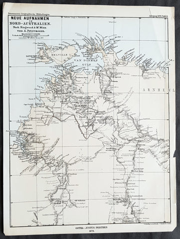
1878 Petermann Antique Map of Northern Territory Australia - William McMinn 1876
- Title : Neue Aufnahmen in Nord-Australien Nach. Ringwood & Mc Minn...Gotha: Justus Perthes 1878
- 10 1/2in x 8 1/2in (265mm x 215mm)
- Condition: (A+) Fine Condition
- Date : 1878
- Ref #: 82058
Description:
This scarce original antique lithograph map of north-west Northern Territory, Australia showing Palmerston at Port Darwin, place names and exploration routes, including that of William McMinn in 1876, by Augustus Heinrich Petermann was engraved in 1878 - dated - and was published by Justus Perthes, Gotha Germany.
General Definitions:
Paper thickness and quality: - Heavy and stable
Paper color : - off white
Age of map color: - Original
Colors used: - Yellow, blue
General color appearance: - Authentic
Paper size: - 10 1/2in x 8 1/2in (265mm x 215mm)
Plate size: - 10 1/2in x 8 1/2in (265mm x 215mm)
Margins: - Min 1/2in (12mm)
Imperfections:
Margins: - None
Plate area: - None
Verso: - None
Background:
William McMinn (1844 – 14 February 1884) was an Australian surveyor and architect, based in Adelaide.
He was born in Newry, County Down, Ireland, a son of Joseph McMinn and his wife Martha McMinn (née Hamill), who with their large family emigrated to Adelaide on the Albatross, arriving in September 1850.
After completing school, he was apprenticed to the architect James Macgeorge, but first practiced as a surveyor. He was involved in Boyle Travers Finniss\'s ill-fated 1865 expedition to Northern Australia surveying the area around the Adelaide River. Following the desertion of a majority of the party to Singapore, McMinn and 5 others purchased a 23-foot open boat which they named the Forlorn Hope and sailed it 2,000 miles (3,200 km) to Champion Bay, Geraldton, Western Australia. He was later involved in the 1872 surveying of the Overland Telegraph from Port Augusta to Darwin.
McMinn began practising as an architect in 1867, briefly in partnership with Daniel Garlick, and later with some others, but usually independently. He designed many grand private residences, but also designed or assisted in the design of many of Adelaide\'s grand public buildings. Whilst in partnership with Edward John Woods, he designed the original Venetian Gothic building of the University of Adelaide, considered his greatest work.
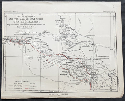
1890 Petermann Antique Map Lake Eyre to The Musgrave Ranges South Australia
- Title : Karte der Gegend zwischen Lake Eyre den Musgrave Ranges in Sud-Australien...Gotha: Justus Perthes 1890
- 10 1/2in x 8 1/2in (265mm x 215mm)
- Condition: (A+) Fine Condition
- Date : 1890
- Ref #: 82060
Description:
This original antique lithograph map of the area between Lake Eyre the Musgrave ranges in South Australia - with the tracks of 8 explorers of the region - by Augustus Heinrich Petermann was engraved in 1890 - dated - and was published by Justus Perthes, Gotha Germany.
General Definitions:
Paper thickness and quality: - Heavy and stable
Paper color : - off white
Age of map color: - Original
Colors used: - Red
General color appearance: - Authentic
Paper size: - 10 1/2in x 8 1/2in (265mm x 215mm)
Plate size: - 10 1/2in x 8 1/2in (265mm x 215mm)
Margins: - Min 1/2in (12mm)
Imperfections:
Margins: - None
Plate area: - Folds as issued
Verso: - None
Background:
The tracks of 8 different explorers are covered in this map. They are:
1. Sturat 1858-62
2. Giles 1873 - 1876
3. Lewis 1874 - 1875
4. Lindsay 1885 & 86
5. Gosse 1872
6. Forrest 1874
7. Ross & Harvey
8. Brown 1889


