
Sydney Hall (1818 - 1860)
Profile :
Sydney Hall was responsible for many fine maps in many publications during the early 19th century. His eye for detail was greatly admired and much copied and although his maps were not decorative, in the 17th and 18th century style, they served their purpose well during a period when maps were used much more for purpose than decoration
Sydney Hall (14)
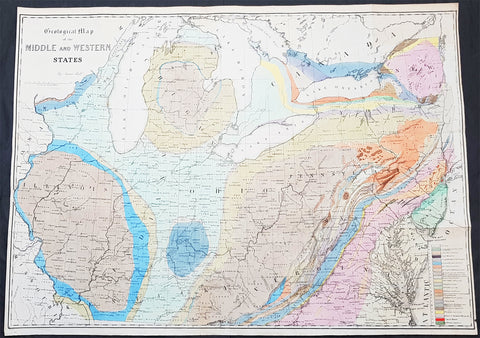
1843 James Hall Large Antique Geological Map of the United States & Great Lakes
Antique Map
- Title : Geological Map of the Middle and Western States by James Hall
- Date : 1843
- Size: 32 1/2in x 24in (825mm x 610mm)
- Ref #: 93061
- Condition: (A+) Fine Condition
Description:
This large original steel plate engraved, hand coloured antique Geological map from the Mississippi River to the Atlantic Ocean and from the Straits of Michilimackinac (Michillimaoinac) and Montreal, Canada to Virginia, Kentucky, and Missouri by James Hall was published in the 1843 edition of Halls Geology of New York. Part IV. Comprising the Survey of the Fourth Geological District
General Definitions:
Paper thickness and quality: - Heavy and stable
Paper color : - off white
Age of map color: - Original
Colors used: - Yellow, green, blue, pink
General color appearance: - Authentic
Paper size: - 32 1/2in x 24in (825mm x 610mm)
Plate size: - 32 1/2in x 24in (825mm x 610mm)
Margins: - Min 1/2in (12mm)
Imperfections:
Margins: - None
Plate area: - None
Verso: - None
Background:
The New York System of Geology
Hall’s map can be regarded as a landmark work as it was one of the earliest known maps to employ the New York System, of stratigraphic nomenclature developed by Hall and others at the New York Geological Survey. The system emphasized the importance of paleontology for delineating geological units and introduced the concept of type locality, a primary reference location used for defining the characteristics of geological formations. This map is the first regional application of the system, which evolved into the standard nomenclature used today for North America and much of the rest of the world.
Hall, James 1811 - 1898
Hall was an American paleontologist and geologist. Born in Hingham, Massachusetts, Hall was the oldest of four children born to James Hall Sr. and Sousanna Dourdain Hall, who had emigrated from England two years earlier. Hall attended the Rensselaer Polytechnic Institute, from which he graduated with honors in 1832 and he received a masters degree from the same institution the following year. After completing his masters degree, Hall stayed at Rensselaer and taught chemistry and later geology. In 1836, Hall was appointed to the team working on a geological and natural history of New York. That first year he was assigned as Ebenezer Emmonss assistant, for who he studied iron deposits in the Adirondack Mountains. The following year, after the survey was reorganized, Hall was put in charge of the Fourth District, in western New York. After completing the survey in 1841, Hall was named the first state paleontologist of New York. Hall published the findings of the survey in 1843 as Geology of New York Part IV. This work received much acclaim and became a classic in the field. Thanks to this success, Hall had established a solid reputation and spent the rest of his life studying stratigraphic geology and invertebrate paleontology. Hall constructed a laboratory in Albany, New York, which quickly became an important institution for aspiring geologists and paleontologists to study and train. Today, this laboratory is known as the James Hall Office and was designated a National Historic Landmark in 1976. Following the survey of New York, Hall participated in a geological survey of northern Michigan and Wisconsin in 1850, and served as state geologist for Iowa from 1855 until 1858 and for Wisconsin from 1857 until 1860. In 1866, Hall was appointed the director of the New York State Museum of Natural History in Albany, and was appointed State Geologist of New York in 1893. Hall was a founding member of the National Academy of Sciences and served as the first president of the Geological Society of America. In 1838, Hall married Sarah Aikin, with whom he had two daughters and two sons. Sarah passed away in 1895.
Endicott and Company (fl. c. 1828 - 1891) was a New York based family run lithography firm that flourished throughout the 19th century. The firm was founded by George and William Endicott, brothers who were born in Canton, Massachusetts. George Endicott (June 14, 1802 - 1848) trained as a lithographer under Pendleton Lithography from January of 1826. He later worked as superintendent of Senefelder Company until the summer of 1828. Afterwards, in 1830, he relocated to Baltimore and partnered with Moses Swett. Endicott and Swett relocated to New York City in December of 1831. They remained partners until July of 1834 when the relationship dissolved. George set up shop on his own account at 359 Broadway. William Endicott (1815 - 1851), Georges younger brother of 14 years, joined the firm in 1840 and was made a partner in 1845, after which the name of the firm was changed to G. and W. Endicott. George Endicott died shortly afterward, in 1848, but William continued operating the firm as William Endicott and Co. until his own 1851 death at just 35 years. The firm was carried on by his widow Sara Munroe Endicott until it was taken over by her son, Francis Endicott, who ran the firm from 1852 to 1886. George Endicott, Jr. subsequently ran the firm from 1887 to 1891. Peters, in his important work on American lithography America on Stone writes it is hard to summarize the Endicotts. They did everything and did it well . . . [they] worked with and for Currier and Ives, yet in spite of all that much of their work lacks real individuality. The Endicott firm was responsible for many 19th century views and plans of New York City and state as well as plans of Sacramento, California, and the Midwest.
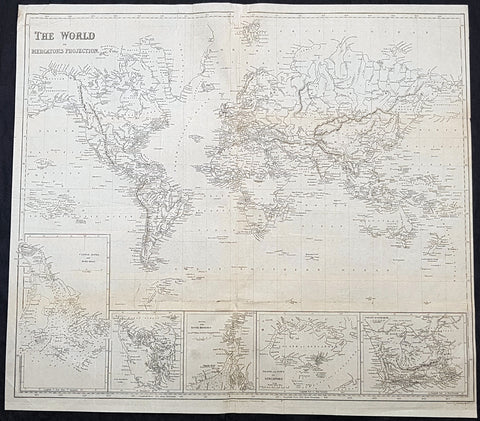
1845 Sydney Hall Large Antique World Map insets Singapore, Hong Kong, Cape, TAS
- Title : 1845 Sydney Hall Large Antique World Map insets Singapore, Hong Kong, Cape, TAS
- Size: 22in x 19 1/2in (500mm x 470mm)
- Condition: (A) Good Condition
- Date : 1843
- Ref #: 32258-1
Description:
This large original steel-plate antique world map - with 5 inset maps of Hong Kong, Van Diemens Land, Calcutta, Singapore & the Colony Of Good Hope - by Sydney Hall was published by Longman & co. in 1845. (Ref: Tooley; M&B)
General Definitions:
Paper thickness and quality: - Light and stable
Paper color : - off white
Age of map color: -
Colors used: -
General color appearance: -
Paper size: - 22in x 19 1/2in (500mm x 470mm)
Plate size: - 22in x 19 1/2in (500mm x 470mm)
Margins: - Min 1/4in (6mm)
Imperfections:
Margins: - Small loss to top centerfold, into border
Plate area: - Folds as issued, light creasing
Verso: - Folds re-enforced with archival tape, light soiling
Background:
A highly detailed and attractive map of the world, with seven inset maps of British colonies: Hong Kong, Van Diemens Land, Calcutta, Singapore & the Colony Of Good Hope. A note on the Pitcairn Islands records their colonisation by the mutineers from the Bounty.
Also prominent in North America is an independent Texas along with an extended Mexico into the SW and California regions.
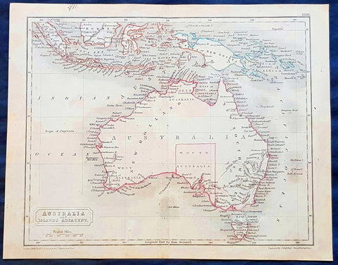
1830 Sydney Hall Antique Map of Australia, New Holland, Swan River Settlement
- Title : Australia & Islands Adjacent
- Ref #: 35074
- Size: 10 1/2in x 8 1/2in (265mm x 210mm)
- Date : 1830
- Condition: (A) Very Good Condition
Description:
This original hand coloured copper-plate original antique map by Sydney Hall was published in the 1830 edition of Halls General Atlas published by Longman & co., London. (Ref: Tooley; M&B)
General Definitions:
Paper thickness and quality: - Heavy and stable
Paper color : - off white
Age of map color: -
Colors used: -
General color appearance: -
Paper size: - 10 1/2in x 8 1/2in (265mm x 210mm)
Plate size: - 10 1/2in x 8 1/2in (265mm x 210mm)
Margins: - Min 1/2in (12mm)
Imperfections:
Margins: - None
Plate area: - Folds as issued
Verso: - None
Background:
The first recorded European sighting of the Australian mainland, and the first recorded European landfall on the Australian continent (in 1606), are attributed to the Dutch. The first ship and crew to chart the Australian coast and meet with Aboriginal people was the Duyfken captained by Dutch navigator, Willem Janszoon. He sighted the coast of Cape York Peninsula in early 1606, and made landfall on 26 February at the Pennefather River near the modern town of Weipa on Cape York. The Dutch charted the whole of the western and northern coastlines and named the island continent New Holland during the 17th century, but made no attempt at settlement. William Dampier, an English explorer and privateer, landed on the north-west coast of New Holland in 1688 and again in 1699 on a return trip. In 1770, James Cook sailed along and mapped the east coast, which he named New South Wales and claimed for Great Britain.
With the loss of its American colonies in 1783, the British Government sent a fleet of ships, the First Fleet, under the command of Captain Arthur Phillip, to establish a new penal colony in New South Wales. A camp was set up and the flag raised at Sydney Cove, Port Jackson, on 26 January 1788, a date which became Australia\'s national day, Australia Day. A British settlement was established in Van Diemens Land, now known as Tasmania, in 1803, and it became a separate colony in 1825. The United Kingdom formally claimed the western part of Western Australia (the Swan River Colony) in 1828. Separate colonies were carved from parts of New South Wales: South Australia in 1836, Victoria in 1851, and Queensland in 1859. The Northern Territory was founded in 1911 when it was excised from South Australia. South Australia was founded as a free province—it was never a penal colony. Victoria and Western Australia were also founded free, but later accepted transported convicts. A campaign by the settlers of New South Wales led to the end of convict transportation to that colony; the last convict ship arrived in 1848.
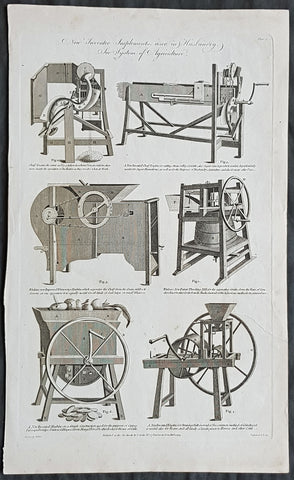
1794 William Hall Antique Print Newly Invented Farm machinery Thrashing Machines
- Title : New Invented Implements used in Husbandry....Royal Encylopedia....C Cooke....1794
- Date : 1794
- Condition: (A+) Fine Condition
- Ref: 91127
- Size: 15in x 9in (380mm x 230mm)
Description:
This large original copper-plate engraved antique print by William Henry Hall was published in the 1798 edition of The new royal encyclopedia; or, complete modern universal dictionary of arts and sciences on a new and improved plan.... Charles Cooke, London.
General Definitions:
Paper thickness and quality: - Heavy and stable
Paper color : - off white
Age of map color: -
Colors used: -
General color appearance: -
Paper size: - 15in x 9in (380mm x 230mm)
Plate size: - 14 1/2in x 8 1/2in (370mm x 215mm)
Margins: - Min 1/2in (12mm)
Imperfections:
Margins: - None
Plate area: - None
Verso: - None
Hall, William Henry
Hall was responsible for a significant publication in the middle of the 18th century The new royal encyclopedia; or, complete modern universal dictionary of arts and sciences on a new and improved plan . containing a digest and display of the whole theory and practice of the liberal and mechanical arts comprising a general repository of ancient and modern literature . including all the material information that is contained in Chamber s Cyclopedia, the Encyclopædia Britannica, and the French Encyclopædie . first published in 1788 going into many re-issues over the next 50 years.
The three volume set contained 153 copper-plate prints and maps, including some folding maps. Contained many brief encyclopedic entries in alphabetical orders plus longer, mainly illustrated, sections (systems or treatises) on a variety of subjects: Aerology; Aerostation (hot air balloons); Agriculture; Algebra; Amphibiology; Anatomy; Annuities; Architecture; Arithmetic; Astronomy (includes plates of telescopes); Book-Keeping; Botany; Brewing; Chronology; Chymistry; Comparative Anatomy; Concology; Dialling; Distillation; Drawing; Earth; Earthquakes; Electricity; Entomology; Farriery; Fencing; Fluxions; Fortification; Gardening; Geography (this section includes six folding maps); Geometry; Globes; Grammar; Heraldry; Hydrostatics and Hydraulics (one plate included a diving bell); Icthyology; Knighthood; Logic; Mammalia (included a plate showing whales); Mechanics; Medicine; Mensuration and Gauging; Miscroscopic Apparatus (microscopes); Midwifery; Military Affairs; Music; Natural History; Naval Affairs; Navigation (includes a folding map showing Cooks voyages); Optics; Oratory; Ornithology; Peerage; Perspective; Pneumatics; Projectiles; Steam Engines; Surgery; Surveying; Trigonometry; Vermeology; Volcanos; and War. Hard to find a complete set, as many have been broken up for their handsome copper plate engravings and maps.
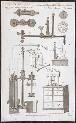
1798 William Hall Antique Print of Pneumatic Air Pump Parts, Air Powered Rifles
- Title : A View with Sections of Princes American Air Pumpwhich is Superior to Smeatons & every other modern construction....Royal Encylopedia....C Cooke....
- Date : 1798
- Condition: (A) Very Good Condition
- Ref: 91136
- Size: 15in x 9in (380mm x 230mm)
Description:
This large original copper-plate engraved antique print by William Henry Hall was published in the 1798 edition of The new royal encyclopedia; or, complete modern universal dictionary of arts and sciences on a new and improved plan.... Charles Cooke, London.
General Definitions:
Paper thickness and quality: - Heavy and stable
Paper color : - off white
Age of map color: -
Colors used: -
General color appearance: -
Paper size: - 15in x 9in (380mm x 230mm)
Plate size: - 14 1/2in x 8 1/2in (370mm x 215mm)
Margins: - Min 1/2in (12mm)
Imperfections:
Margins: - Light age toning in margins
Plate area: - None
Verso: - None
Hall, William Henry
Hall was responsible for a significant publication in the middle of the 18th century The new royal encyclopedia; or, complete modern universal dictionary of arts and sciences on a new and improved plan . containing a digest and display of the whole theory and practice of the liberal and mechanical arts comprising a general repository of ancient and modern literature . including all the material information that is contained in Chamber s Cyclopedia, the Encyclopædia Britannica, and the French Encyclopædie . first published in 1788 going into many re-issues over the next 50 years.
The three volume set contained 153 copper-plate prints and maps, including some folding maps. Contained many brief encyclopedic entries in alphabetical orders plus longer, mainly illustrated, sections (systems or treatises) on a variety of subjects: Aerology; Aerostation (hot air balloons); Agriculture; Algebra; Amphibiology; Anatomy; Annuities; Architecture; Arithmetic; Astronomy (includes plates of telescopes); Book-Keeping; Botany; Brewing; Chronology; Chymistry; Comparative Anatomy; Concology; Dialling; Distillation; Drawing; Earth; Earthquakes; Electricity; Entomology; Farriery; Fencing; Fluxions; Fortification; Gardening; Geography (this section includes six folding maps); Geometry; Globes; Grammar; Heraldry; Hydrostatics and Hydraulics (one plate included a diving bell); Icthyology; Knighthood; Logic; Mammalia (included a plate showing whales); Mechanics; Medicine; Mensuration and Gauging; Miscroscopic Apparatus (microscopes); Midwifery; Military Affairs; Music; Natural History; Naval Affairs; Navigation (includes a folding map showing Cooks voyages); Optics; Oratory; Ornithology; Peerage; Perspective; Pneumatics; Projectiles; Steam Engines; Surgery; Surveying; Trigonometry; Vermeology; Volcanos; and War. Hard to find a complete set, as many have been broken up for their handsome copper plate engravings and maps.
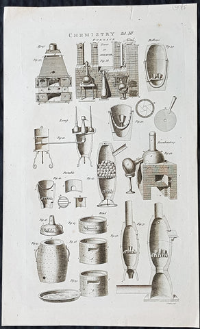
1798 William Hall Antique Print of Chemistry Furnace or Ovens & Sectional Parts
- Title : Chemistry Tab III Furnace Tower or Athanor....Royal Encylopedia....C Cooke....
- Date : 1798
- Condition: (A+) Fine Condition
- Ref: 26247
- Size: 16 1/2in x 10in (420mm x 255mm)
Description:
This large original copper-plate engraved antique print by William Henry Hall was published in the 1798 edition of The new royal encyclopedia; or, complete modern universal dictionary of arts and sciences on a new and improved plan.... Charles Cooke, London.
General Definitions:
Paper thickness and quality: - Heavy and stable
Paper color : - off white
Age of map color: -
Colors used: -
General color appearance: -
Paper size: - 16 1/2in x 10in (420mm x 255mm)
Plate size: - 14 1/2in x 8 1/2in (370mm x 215mm)
Margins: - Min 1/2in (12mm)
Imperfections:
Margins: - None
Plate area: - None
Verso: - None
Hall, William Henry
Hall was responsible for a significant publication in the middle of the 18th century The new royal encyclopedia; or, complete modern universal dictionary of arts and sciences on a new and improved plan . containing a digest and display of the whole theory and practice of the liberal and mechanical arts comprising a general repository of ancient and modern literature . including all the material information that is contained in Chamber s Cyclopedia, the Encyclopædia Britannica, and the French Encyclopædie . first published in 1788 going into many re-issues over the next 50 years.
The three volume set contained 153 copper-plate prints and maps, including some folding maps. Contained many brief encyclopedic entries in alphabetical orders plus longer, mainly illustrated, sections (systems or treatises) on a variety of subjects: Aerology; Aerostation (hot air balloons); Agriculture; Algebra; Amphibiology; Anatomy; Annuities; Architecture; Arithmetic; Astronomy (includes plates of telescopes); Book-Keeping; Botany; Brewing; Chronology; Chymistry; Comparative Anatomy; Concology; Dialling; Distillation; Drawing; Earth; Earthquakes; Electricity; Entomology; Farriery; Fencing; Fluxions; Fortification; Gardening; Geography (this section includes six folding maps); Geometry; Globes; Grammar; Heraldry; Hydrostatics and Hydraulics (one plate included a diving bell); Icthyology; Knighthood; Logic; Mammalia (included a plate showing whales); Mechanics; Medicine; Mensuration and Gauging; Miscroscopic Apparatus (microscopes); Midwifery; Military Affairs; Music; Natural History; Naval Affairs; Navigation (includes a folding map showing Cooks voyages); Optics; Oratory; Ornithology; Peerage; Perspective; Pneumatics; Projectiles; Steam Engines; Surgery; Surveying; Trigonometry; Vermeology; Volcanos; and War. Hard to find a complete set, as many have been broken up for their handsome copper plate engravings and maps.
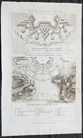
1798 William Hall Antique Print Methods of Defending, Laying Mines Fortification
- Title : Art of War: Fig I. Represents The Method of placing Mines in a Siege; Fig 2. Representation of a fortified Place besieged....Royal Encylopedia....C Cooke....
- Date : 1798
- Condition: (A+) Fine Condition
- Ref: 01-7334
- Size: 15in x 9in (380mm x 230mm)
Description:
This large original copper-plate engraved antique print by William Henry Hall was published in the 1798 edition of The new royal encyclopedia; or, complete modern universal dictionary of arts and sciences on a new and improved plan.... Charles Cooke, London.
General Definitions:
Paper thickness and quality: - Heavy and stable
Paper color : - off white
Age of map color: -
Colors used: -
General color appearance: -
Paper size: - 15in x 9in (380mm x 230mm)
Plate size: - 13 1/2in x 8 1/2in (345mm x 215mm)
Margins: - Min 1/2in (12mm)
Imperfections:
Margins: - None
Plate area: - None
Verso: - None
Hall, William Henry
Hall was responsible for a significant publication in the middle of the 18th century The new royal encyclopedia; or, complete modern universal dictionary of arts and sciences on a new and improved plan . containing a digest and display of the whole theory and practice of the liberal and mechanical arts comprising a general repository of ancient and modern literature . including all the material information that is contained in Chamber s Cyclopedia, the Encyclopædia Britannica, and the French Encyclopædie . first published in 1788 going into many re-issues over the next 50 years.
The three volume set contained 153 copper-plate prints and maps, including some folding maps. Contained many brief encyclopedic entries in alphabetical orders plus longer, mainly illustrated, sections (systems or treatises) on a variety of subjects: Aerology; Aerostation (hot air balloons); Agriculture; Algebra; Amphibiology; Anatomy; Annuities; Architecture; Arithmetic; Astronomy (includes plates of telescopes); Book-Keeping; Botany; Brewing; Chronology; Chymistry; Comparative Anatomy; Concology; Dialling; Distillation; Drawing; Earth; Earthquakes; Electricity; Entomology; Farriery; Fencing; Fluxions; Fortification; Gardening; Geography (this section includes six folding maps); Geometry; Globes; Grammar; Heraldry; Hydrostatics and Hydraulics (one plate included a diving bell); Icthyology; Knighthood; Logic; Mammalia (included a plate showing whales); Mechanics; Medicine; Mensuration and Gauging; Miscroscopic Apparatus (microscopes); Midwifery; Military Affairs; Music; Natural History; Naval Affairs; Navigation (includes a folding map showing Cooks voyages); Optics; Oratory; Ornithology; Peerage; Perspective; Pneumatics; Projectiles; Steam Engines; Surgery; Surveying; Trigonometry; Vermeology; Volcanos; and War. Hard to find a complete set, as many have been broken up for their handsome copper plate engravings and maps.
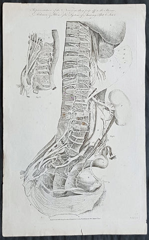
1795 William Hall Antique Print The Human Nervous System Thorax Abdomen & Pelvis
- Title : Representation of the Nerves as they pass off to the Thorax Abdomen & Pelvis....Royal Encylopedia....C Cooke...1795
- Date : 1795
- Condition: (A) Very Good Condition
- Ref: 01-7324
- Size: 15in x 9in (380mm x 230mm)
Description:
This large original copper-plate engraved antique print by William Henry Hall was engraved in 1795 - dated - and was published in the 1798 edition of The new royal encyclopedia; or, complete modern universal dictionary of arts and sciences on a new and improved plan.... Charles Cooke, London.
General Definitions:
Paper thickness and quality: - Heavy and stable
Paper color : - off white
Age of map color: -
Colors used: -
General color appearance: -
Paper size: - 15in x 9in (380mm x 230mm)
Plate size: - 13 1/2in x 8 1/2in (345mm x 215mm)
Margins: - Min 1/2in (12mm)
Imperfections:
Margins: - None
Plate area: - None
Verso: - None
Hall, William Henry
Hall was responsible for a significant publication in the middle of the 18th century The new royal encyclopedia; or, complete modern universal dictionary of arts and sciences on a new and improved plan . containing a digest and display of the whole theory and practice of the liberal and mechanical arts comprising a general repository of ancient and modern literature . including all the material information that is contained in Chamber s Cyclopedia, the Encyclopædia Britannica, and the French Encyclopædie . first published in 1788 going into many re-issues over the next 50 years.
The three volume set contained 153 copper-plate prints and maps, including some folding maps. Contained many brief encyclopedic entries in alphabetical orders plus longer, mainly illustrated, sections (systems or treatises) on a variety of subjects: Aerology; Aerostation (hot air balloons); Agriculture; Algebra; Amphibiology; Anatomy; Annuities; Architecture; Arithmetic; Astronomy (includes plates of telescopes); Book-Keeping; Botany; Brewing; Chronology; Chymistry; Comparative Anatomy; Concology; Dialling; Distillation; Drawing; Earth; Earthquakes; Electricity; Entomology; Farriery; Fencing; Fluxions; Fortification; Gardening; Geography (this section includes six folding maps); Geometry; Globes; Grammar; Heraldry; Hydrostatics and Hydraulics (one plate included a diving bell); Icthyology; Knighthood; Logic; Mammalia (included a plate showing whales); Mechanics; Medicine; Mensuration and Gauging; Miscroscopic Apparatus (microscopes); Midwifery; Military Affairs; Music; Natural History; Naval Affairs; Navigation (includes a folding map showing Cooks voyages); Optics; Oratory; Ornithology; Peerage; Perspective; Pneumatics; Projectiles; Steam Engines; Surgery; Surveying; Trigonometry; Vermeology; Volcanos; and War. Hard to find a complete set, as many have been broken up for their handsome copper plate engravings and maps.
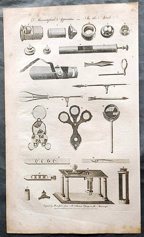
1798 W H Hall Large Antique Print of the Apparatus of The Microscope, Lenses
Antique Map
- Title : Microscophical Apparatus....Halls Encyclopedia...C. Cooke...
- Condition: (A) Very Good Condition
- Ref: 90677
- Size: 15in x 9in (380mm x 230mm)
- Date: 1798
Description:
This large original copper-plate engraved antique print was was published by William Henry Hall in the 1798 edition of The new royal encyclopedia; or, complete modern universal dictionary of arts and sciences on a new and improved plan.... printed by Charles Cooke, London.
General Definitions:
Paper thickness and quality: - Heavy and stable
Paper color : - off white
Age of map color: -
Colors used: -
General color appearance: -
Paper size: - 15in x 9in (380mm x 230mm)
Plate size: - 15in x 9in (380mm x 230mm)
Margins: - Min 1/2in (10mm)
Imperfections:
Margins: - Age toning
Plate area: - Light age toning
Verso: - Age toning
Background:
Although objects resembling lenses date back 4000 years and there are Greek accounts of the optical properties of water-filled spheres (5th century BC) followed by many centuries of writings on optics, the earliest known use of simple microscopes (magnifying glasses) dates back to the widespread use of lenses in eyeglasses in the 13th century. The earliest known examples of compound microscopes, which combine an objective lens near the specimen with an eyepiece to view a real image, appeared in Europe around 1620. The inventor is unknown although many claims have been made over the years. Several revolve around the spectacle-making centers in the Netherlands including claims it was invented in 1590 by Zacharias Janssen (claim made by his son) and/or Zacharias father, Hans Martens, claims it was invented by their neighbor and rival spectacle maker, Hans Lippershey (who applied for the first telescope patent in 1608) and claims it was invented by expatriate Cornelis Drebbel who was noted to have a version in London in 1619. Galileo Galilei (also sometimes cited as compound microscope inventor) seems to have found after 1610 that he could close focus his telescope to view small objects and, after seeing a compound microscope built by Drebbel exhibited in Rome in 1624, built his own improved version. Giovanni Faber coined the name microscope for the compound microscope Galileo submitted to the Accademia dei Lincei in 1625 (Galileo had called it the occhiolino or little eye).
The first detailed account of the microscopic anatomy of organic tissue based on the use of a microscope did not appear until 1644, in Giambattista Odiernas Locchio della mosca, or The Flys Eye.
The microscope was still largely a novelty until the 1660s and 1670s when naturalists in Italy, the Netherlands and England began using them to study biology. Italian scientist Marcello Malpighi, called the father of histology by some historians of biology, began his analysis of biological structures with the lungs. Robert Hookes Micrographia had a huge impact, largely because of its impressive illustrations. A significant contribution came from Antonie van Leeuwenhoek who achieved up to 300 times magnification using a simple single lens microscope. He sandwiched a very small glass ball lens between the holes in two metal plates riveted together, and with an adjustable-by-screws needle attached to mount the specimen. Then, Van Leeuwenhoek re-discovered red blood cells (after Jan Swammerdam) and spermatozoa, and helped popularise the use of microscopes to view biological ultrastructure. On 9 October 1676, van Leeuwenhoek reported the discovery of micro-organisms.
The performance of a light microscope depends on the quality and correct use of the condensor lens system to focus light on the specimen and the objective lens to capture the light from the specimen and form an image. Early instruments were limited until this principle was fully appreciated and developed from the late 19th to very early 20th century, and until electric lamps were available as light sources. In 1893 August Köhler developed a key principle of sample illumination, Köhler illumination, which is central to achieving the theoretical limits of resolution for the light microscope. This method of sample illumination produces even lighting and overcomes the limited contrast and resolution imposed by early techniques of sample illumination. Further developments in sample illumination came from the discovery of phase contrast by Frits Zernike in 1953, and differential interference contrast illumination by Georges Nomarski in 1955; both of which allow imaging of unstained, transparent samples.
Hall, William Henry
Hall was responsible for a significant publication in the middle of the 18th century The new royal encyclopedia; or, complete modern universal dictionary of arts and sciences on a new and improved plan . containing a digest and display of the whole theory and practice of the liberal and mechanical arts comprising a general repository of ancient and modern literature . including all the material information that is contained in Chamber s Cyclopedia, the Encyclopædia Britannica, and the French Encyclopædie . first published in 1788 going into many re-issues over the next 50 years.
The three volume set contained 153 copper-plate prints and maps, including some folding maps. Contained many brief encyclopedic entries in alphabetical orders plus longer, mainly illustrated, sections (systems or treatises) on a variety of subjects: Aerology; Aerostation (hot air balloons); Agriculture; Algebra; Amphibiology; Anatomy; Annuities; Architecture; Arithmetic; Astronomy (includes plates of telescopes); Book-Keeping; Botany; Brewing; Chronology; Chymistry; Comparative Anatomy; Concology; Dialling; Distillation; Drawing; Earth; Earthquakes; Electricity; Entomology; Farriery; Fencing; Fluxions; Fortification; Gardening; Geography (this section includes six folding maps); Geometry; Globes; Grammar; Heraldry; Hydrostatics and Hydraulics (one plate included a diving bell); Icthyology; Knighthood; Logic; Mammalia (included a plate showing whales); Mechanics; Medicine; Mensuration and Gauging; Miscroscopic Apparatus (microscopes); Midwifery; Military Affairs; Music; Natural History; Naval Affairs; Navigation (includes a folding map showing Cooks voyages); Optics; Oratory; Ornithology; Peerage; Perspective; Pneumatics; Projectiles; Steam Engines; Surgery; Surveying; Trigonometry; Vermeology; Volcanos; and War. Hard to find a complete set, as many have been broken up for their handsome copper plate engravings and maps.
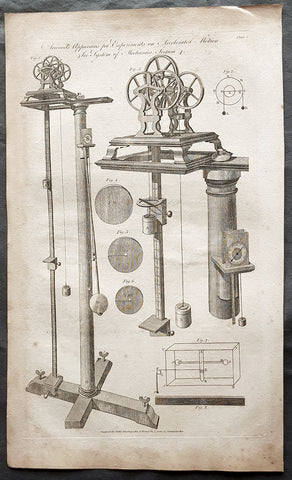
1798 W H Hall Large Antique Print of Atwood's Machine, Mechanical Laws of Motion
Antique Map
- Title : Atwoods Apparatus for Experiments on Accelerated Motion....Halls Encyclopedia...C. Cooke...
- Condition: (A) Very Good Condition
- Ref: 90676
- Size: 15in x 9in (380mm x 230mm)
- Date: 1798
Description:
This large original copper-plate engraved antique print was was published by William Henry Hall in the 1798 edition of The new royal encyclopedia; or, complete modern universal dictionary of arts and sciences on a new and improved plan.... printed by Charles Cooke, London.
General Definitions:
Paper thickness and quality: - Heavy and stable
Paper color : - off white
Age of map color: -
Colors used: -
General color appearance: -
Paper size: - 15in x 9in (380mm x 230mm)
Plate size: - 15in x 9in (380mm x 230mm)
Margins: - Min 1/2in (10mm)
Imperfections:
Margins: - Age toning
Plate area: - Light age toning
Verso: - Age toning
Background:
The Atwood machine (or Atwoods machine) was invented in 1784 by the English mathematician George Atwood as a laboratory experiment to verify the mechanical laws of motion with constant acceleration. Atwoods machine is a common classroom demonstration used to illustrate principles of classical mechanics.
The ideal Atwood machine consists of two objects of mass m1 and m2, connected by an inextensible massless string over an ideal massless pulley.
Both masses experience uniform acceleration. When m1 = m2, the machine is in neutral equilibrium regardless of the position of the weights.
Hall, William Henry
Hall was responsible for a significant publication in the middle of the 18th century The new royal encyclopedia; or, complete modern universal dictionary of arts and sciences on a new and improved plan . containing a digest and display of the whole theory and practice of the liberal and mechanical arts comprising a general repository of ancient and modern literature . including all the material information that is contained in Chamber s Cyclopedia, the Encyclopædia Britannica, and the French Encyclopædie . first published in 1788 going into many re-issues over the next 50 years.
The three volume set contained 153 copper-plate prints and maps, including some folding maps. Contained many brief encyclopedic entries in alphabetical orders plus longer, mainly illustrated, sections (systems or treatises) on a variety of subjects: Aerology; Aerostation (hot air balloons); Agriculture; Algebra; Amphibiology; Anatomy; Annuities; Architecture; Arithmetic; Astronomy (includes plates of telescopes); Book-Keeping; Botany; Brewing; Chronology; Chymistry; Comparative Anatomy; Concology; Dialling; Distillation; Drawing; Earth; Earthquakes; Electricity; Entomology; Farriery; Fencing; Fluxions; Fortification; Gardening; Geography (this section includes six folding maps); Geometry; Globes; Grammar; Heraldry; Hydrostatics and Hydraulics (one plate included a diving bell); Icthyology; Knighthood; Logic; Mammalia (included a plate showing whales); Mechanics; Medicine; Mensuration and Gauging; Miscroscopic Apparatus (microscopes); Midwifery; Military Affairs; Music; Natural History; Naval Affairs; Navigation (includes a folding map showing Cooks voyages); Optics; Oratory; Ornithology; Peerage; Perspective; Pneumatics; Projectiles; Steam Engines; Surgery; Surveying; Trigonometry; Vermeology; Volcanos; and War. Hard to find a complete set, as many have been broken up for their handsome copper plate engravings and maps.
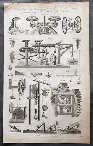
1798 W H Hall Large Antique Print of Drive Trains Cogs Pulleys for Cranes, Mills
Antique Map
- Title : Mechanical Powers with their Applications in Cranes, Mills & other compound Engines....Halls Encyclopedia...C. Cooke...
- Condition: (A) Very Good Condition
- Ref: 90674
- Size: 15in x 9in (380mm x 230mm)
- Date: 1798
Description:
This large original copper-plate engraved antique print was was published by William Henry Hall in the 1798 edition of The new royal encyclopedia; or, complete modern universal dictionary of arts and sciences on a new and improved plan.... printed by Charles Cooke, London.
General Definitions:
Paper thickness and quality: - Heavy and stable
Paper color : - off white
Age of map color: -
Colors used: -
General color appearance: -
Paper size: - 15in x 9in (380mm x 230mm)
Plate size: - 15in x 9in (380mm x 230mm)
Margins: - Min 1/2in (10mm)
Imperfections:
Margins: - Age toning
Plate area: - Light age toning
Verso: - Age toning
Background:
A crane is a type of machine, generally equipped with a hoist rope, wire ropes or chains, and sheaves, that can be used both to lift and lower materials and to move them horizontally. It is mainly used for lifting heavy things and transporting them to other places. The device uses one or more simple machines to create mechanical advantage and thus move loads beyond the normal capability of a human. Cranes are commonly employed in the transport industry for the loading and unloading of freight, in the construction industry for the movement of materials, and in the manufacturing industry for the assembling of heavy equipment.
The first known crane machine was the shadouf, a water-lifting device that was invented in ancient Mesopotamia (modern Iraq) and then appeared in ancient Egyptian technology. Construction cranes later appeared in ancient Greece, where they were powered by men or animals (such as donkeys), and used for the construction of buildings. Larger cranes were later developed in the Roman Empire, employing the use of human treadwheels, permitting the lifting of heavier weights. In the High Middle Ages, harbour cranes were introduced to load and unload ships and assist with their construction — some were built into stone towers for extra strength and stability. The earliest cranes were constructed from wood, but cast iron, iron and steel took over with the coming of the Industrial Revolution.
For many centuries, power was supplied by the physical exertion of men or animals, although hoists in watermills and windmills could be driven by the harnessed natural power. The first mechanical power was provided by steam engines, the earliest steam crane being introduced in the 18th or 19th century, with many remaining in use well into the late 20th century. Modern cranes usually use internal combustion engines or electric motors and hydraulic systems to provide a much greater lifting capability than was previously possible, although manual cranes are still utilized where the provision of power would be uneconomic.
Hall, William Henry
Hall was responsible for a significant publication in the middle of the 18th century The new royal encyclopedia; or, complete modern universal dictionary of arts and sciences on a new and improved plan . containing a digest and display of the whole theory and practice of the liberal and mechanical arts comprising a general repository of ancient and modern literature . including all the material information that is contained in Chamber s Cyclopedia, the Encyclopædia Britannica, and the French Encyclopædie . first published in 1788 going into many re-issues over the next 50 years.
The three volume set contained 153 copper-plate prints and maps, including some folding maps. Contained many brief encyclopedic entries in alphabetical orders plus longer, mainly illustrated, sections (systems or treatises) on a variety of subjects: Aerology; Aerostation (hot air balloons); Agriculture; Algebra; Amphibiology; Anatomy; Annuities; Architecture; Arithmetic; Astronomy (includes plates of telescopes); Book-Keeping; Botany; Brewing; Chronology; Chymistry; Comparative Anatomy; Concology; Dialling; Distillation; Drawing; Earth; Earthquakes; Electricity; Entomology; Farriery; Fencing; Fluxions; Fortification; Gardening; Geography (this section includes six folding maps); Geometry; Globes; Grammar; Heraldry; Hydrostatics and Hydraulics (one plate included a diving bell); Icthyology; Knighthood; Logic; Mammalia (included a plate showing whales); Mechanics; Medicine; Mensuration and Gauging; Miscroscopic Apparatus (microscopes); Midwifery; Military Affairs; Music; Natural History; Naval Affairs; Navigation (includes a folding map showing Cooks voyages); Optics; Oratory; Ornithology; Peerage; Perspective; Pneumatics; Projectiles; Steam Engines; Surgery; Surveying; Trigonometry; Vermeology; Volcanos; and War. Hard to find a complete set, as many have been broken up for their handsome copper plate engravings and maps.
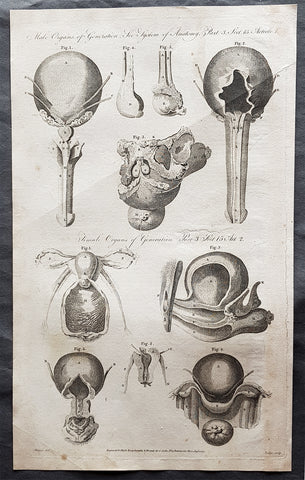
1795 William Henry Hall Large Antique Print of Male & Female Reproductive System
Antique Map
- Title : Male Organs of Generation; Female Organs of Generation...Halls Encyclopedia...C. Cooke 1795
- Condition: (A) Very Good Condition
- Ref: 01-7304
- Size: 15in x 9in (380mm x 230mm)
- Date: 1795
Description:
This large original copper-plate engraved antique print was engraved in 1795 - dated - and was published by William Henry Hall in the 1798 edition of The new royal encyclopedia; or, complete modern universal dictionary of arts and sciences on a new and improved plan.... printed by Charles Cooke, London.
General Definitions:
Paper thickness and quality: - Heavy and stable
Paper color : - off white
Age of map color: -
Colors used: -
General color appearance: -
Paper size: - 15in x 9in (380mm x 230mm)
Plate size: - 15in x 9in (380mm x 230mm)
Margins: - Min 1/2in (10mm)
Imperfections:
Margins: - Age toning
Plate area: - Light age toning
Verso: - Age toning
Background:
The reproductive system or genital system is a system of sex organs within an organism which work together for the purpose of sexual reproduction. Many non-living substances such as fluids, hormones, and pheromones are also important accessories to the reproductive system. Unlike most organ systems, the sexes of differentiated species often have significant differences. These differences allow for a combination of genetic material between two individuals, which allows for the possibility of greater genetic fitness of the offspring.
Hall, William Henry
Hall was responsible for a significant publication in the middle of the 18th century The new royal encyclopedia; or, complete modern universal dictionary of arts and sciences on a new and improved plan . containing a digest and display of the whole theory and practice of the liberal and mechanical arts comprising a general repository of ancient and modern literature . including all the material information that is contained in Chamber s Cyclopedia, the Encyclopædia Britannica, and the French Encyclopædie . first published in 1788 going into many re-issues over the next 50 years.
The three volume set contained 153 copper-plate prints and maps, including some folding maps. Contained many brief encyclopedic entries in alphabetical orders plus longer, mainly illustrated, sections (systems or treatises) on a variety of subjects: Aerology; Aerostation (hot air balloons); Agriculture; Algebra; Amphibiology; Anatomy; Annuities; Architecture; Arithmetic; Astronomy (includes plates of telescopes); Book-Keeping; Botany; Brewing; Chronology; Chymistry; Comparative Anatomy; Concology; Dialling; Distillation; Drawing; Earth; Earthquakes; Electricity; Entomology; Farriery; Fencing; Fluxions; Fortification; Gardening; Geography (this section includes six folding maps); Geometry; Globes; Grammar; Heraldry; Hydrostatics and Hydraulics (one plate included a diving bell); Icthyology; Knighthood; Logic; Mammalia (included a plate showing whales); Mechanics; Medicine; Mensuration and Gauging; Miscroscopic Apparatus (microscopes); Midwifery; Military Affairs; Music; Natural History; Naval Affairs; Navigation (includes a folding map showing Cooks voyages); Optics; Oratory; Ornithology; Peerage; Perspective; Pneumatics; Projectiles; Steam Engines; Surgery; Surveying; Trigonometry; Vermeology; Volcanos; and War. Hard to find a complete set, as many have been broken up for their handsome copper plate engravings and maps.
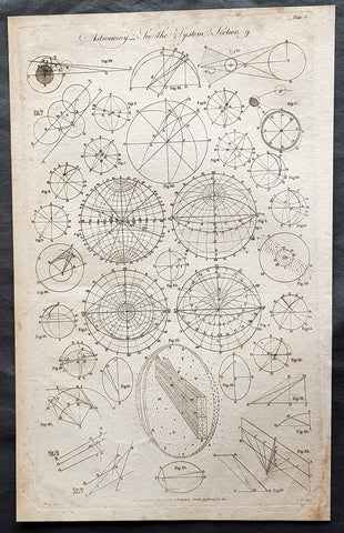
1798 W H Hall Large Antique Astronomical Print of Measurements & Calculations
Antique Map
- Title : Astronomy....Halls Encyclopedia...C. Cooke
- Condition: (A) Very Good Condition
- Ref: 01-7364
- Size: 15in x 9in (380mm x 230mm)
- Date: 1798
Description:
This large original copper-plate engraved antique print was was published by William Henry Hall in the 1798 edition of The new royal encyclopedia; or, complete modern universal dictionary of arts and sciences on a new and improved plan.... printed by Charles Cooke, London.
General Definitions:
Paper thickness and quality: - Heavy and stable
Paper color : - off white
Age of map color: -
Colors used: -
General color appearance: -
Paper size: - 15in x 9in (380mm x 230mm)
Plate size: - 15in x 9in (380mm x 230mm)
Margins: - Min 1/2in (10mm)
Imperfections:
Margins: - Age toning
Plate area: - Light age toning
Verso: - Age toning
Background:
During the Renaissance, Nicolaus Copernicus proposed a heliocentric model of the solar system. His work was defended by Galileo Galilei and expanded upon by Johannes Kepler. Kepler was the first to devise a system that correctly described the details of the motion of the planets around the Sun. However, Kepler did not succeed in formulating a theory behind the laws he wrote down. It was Isaac Newton, with his invention of celestial dynamics and his law of gravitation, who finally explained the motions of the planets. Newton also developed the reflecting telescope.
Improvements in the size and quality of the telescope led to further discoveries. The English astronomer John Flamsteed catalogued over 3000 stars. More extensive star catalogues were produced by Nicolas Louis de Lacaille. The astronomer William Herschel made a detailed catalog of nebulosity and clusters, and in 1781 discovered the planet Uranus, the first new planet found. The distance to a star was announced in 1838 when the parallax of 61 Cygni was measured by Friedrich Bessel.
During the 18–19th centuries, the study of the three-body problem by Leonhard Euler, Alexis Claude Clairaut, and Jean le Rond dAlembert led to more accurate predictions about the motions of the Moon and planets. This work was further refined by Joseph-Louis Lagrange and Pierre Simon Laplace, allowing the masses of the planets and moons to be estimated from their perturbations.
Significant advances in astronomy came about with the introduction of new technology, including the spectroscope and photography. Joseph von Fraunhofer discovered about 600 bands in the spectrum of the Sun in 1814–15, which, in 1859, Gustav Kirchhoff ascribed to the presence of different elements. Stars were proven to be similar to the Earths own Sun, but with a wide range of temperatures, masses, and sizes.
Hall, William Henry
Hall was responsible for a significant publication in the middle of the 18th century The new royal encyclopedia; or, complete modern universal dictionary of arts and sciences on a new and improved plan . containing a digest and display of the whole theory and practice of the liberal and mechanical arts comprising a general repository of ancient and modern literature . including all the material information that is contained in Chamber s Cyclopedia, the Encyclopædia Britannica, and the French Encyclopædie . first published in 1788 going into many re-issues over the next 50 years.
The three volume set contained 153 copper-plate prints and maps, including some folding maps. Contained many brief encyclopedic entries in alphabetical orders plus longer, mainly illustrated, sections (systems or treatises) on a variety of subjects: Aerology; Aerostation (hot air balloons); Agriculture; Algebra; Amphibiology; Anatomy; Annuities; Architecture; Arithmetic; Astronomy (includes plates of telescopes); Book-Keeping; Botany; Brewing; Chronology; Chymistry; Comparative Anatomy; Concology; Dialling; Distillation; Drawing; Earth; Earthquakes; Electricity; Entomology; Farriery; Fencing; Fluxions; Fortification; Gardening; Geography (this section includes six folding maps); Geometry; Globes; Grammar; Heraldry; Hydrostatics and Hydraulics (one plate included a diving bell); Icthyology; Knighthood; Logic; Mammalia (included a plate showing whales); Mechanics; Medicine; Mensuration and Gauging; Miscroscopic Apparatus (microscopes); Midwifery; Military Affairs; Music; Natural History; Naval Affairs; Navigation (includes a folding map showing Cooks voyages); Optics; Oratory; Ornithology; Peerage; Perspective; Pneumatics; Projectiles; Steam Engines; Surgery; Surveying; Trigonometry; Vermeology; Volcanos; and War. Hard to find a complete set, as many have been broken up for their handsome copper plate engravings and maps.
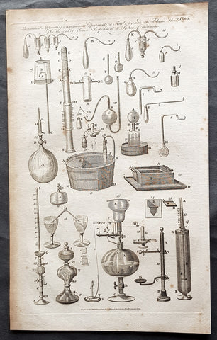
1798 W H Hall Large Antique Print of Various Pneumatic Air & Fluid Equipment
Antique Map
- Title : Pneumatical Apparatus for ascerting Experiments on fixed Air and other Fluids....Halls Encyclopedia...C. Cooke...
- Condition: (A) Very Good Condition
- Ref: 91138
- Size: 15in x 9in (380mm x 230mm)
- Date: 1798
Description:
This large original copper-plate engraved antique print was was published by William Henry Hall in the 1798 edition of The new royal encyclopedia; or, complete modern universal dictionary of arts and sciences on a new and improved plan.... printed by Charles Cooke, London.
General Definitions:
Paper thickness and quality: - Heavy and stable
Paper color : - off white
Age of map color: -
Colors used: -
General color appearance: -
Paper size: - 15in x 9in (380mm x 230mm)
Plate size: - 15in x 9in (380mm x 230mm)
Margins: - Min 1/2in (10mm)
Imperfections:
Margins: - Age toning
Plate area: - Light age toning
Verso: - Age toning
Background:
The origins of pneumatics can be traced back to the first century when ancient Greek mathematician Hero of Alexandria wrote about his inventions powered by steam or the wind.
German physicist Otto von Guericke (1602 to 1686) went a little further. He invented the vacuum pump, a device that can draw out air or gas from the attached vessel. He demonstrated the vacuum pump to separate the pairs of copper hemispheres using air pressures. The field of pneumatics has changed considerably over the years. It has moved from small handheld devices to large machines with multiple parts that serve different functions.
Hall, William Henry
Hall was responsible for a significant publication in the middle of the 18th century The new royal encyclopedia; or, complete modern universal dictionary of arts and sciences on a new and improved plan . containing a digest and display of the whole theory and practice of the liberal and mechanical arts comprising a general repository of ancient and modern literature . including all the material information that is contained in Chamber s Cyclopedia, the Encyclopædia Britannica, and the French Encyclopædie . first published in 1788 going into many re-issues over the next 50 years.
The three volume set contained 153 copper-plate prints and maps, including some folding maps. Contained many brief encyclopedic entries in alphabetical orders plus longer, mainly illustrated, sections (systems or treatises) on a variety of subjects: Aerology; Aerostation (hot air balloons); Agriculture; Algebra; Amphibiology; Anatomy; Annuities; Architecture; Arithmetic; Astronomy (includes plates of telescopes); Book-Keeping; Botany; Brewing; Chronology; Chymistry; Comparative Anatomy; Concology; Dialling; Distillation; Drawing; Earth; Earthquakes; Electricity; Entomology; Farriery; Fencing; Fluxions; Fortification; Gardening; Geography (this section includes six folding maps); Geometry; Globes; Grammar; Heraldry; Hydrostatics and Hydraulics (one plate included a diving bell); Icthyology; Knighthood; Logic; Mammalia (included a plate showing whales); Mechanics; Medicine; Mensuration and Gauging; Miscroscopic Apparatus (microscopes); Midwifery; Military Affairs; Music; Natural History; Naval Affairs; Navigation (includes a folding map showing Cooks voyages); Optics; Oratory; Ornithology; Peerage; Perspective; Pneumatics; Projectiles; Steam Engines; Surgery; Surveying; Trigonometry; Vermeology; Volcanos; and War. Hard to find a complete set, as many have been broken up for their handsome copper plate engravings and maps.