
Sebastian Munster (1489 - 1552)
Profile :
After Waldseemuller three names dominated cartography in the 16th century; Mercator, Ortelius & Munster, and of these three Munster probably had the widest influence in spreading geographical knowledge throughout Europe in the middle years of the century. His Cosmographica, issued in 1544, contained not only the latest views of many well known cities, but included an encyclopedic amount of detail about the known – and unknown – world and undoubtedly must have been one of the most widely read books of its time, going through nearly forty editions in six languages.
An eminent German mathematician and linguist, Munster became professor of Hebrew at Heidelberg and later at Basle, where he settled in 1529. In 1528, following his first mapping of Germany, he appealed to German scholars to send him descriptions, so that all Germany with its villages, towns, trades etc. may be seen in a `mirror`, even going so far as to give instructions on how they should map their own localities. The response was far greater than expected and much information was sent by foreigners as well as Germans so that, eventually, he was able to include many up-to-date, if not very accurate, maps in his atlases. He was the first to provide a separate map of each of the four known continents and the first separately printed map of England. His maps, printed from woodblocks, are now greatly valued by collectors. His two major works, the Geographia and Cosmographia were published in Basle by his sep-son, Henri Petri, who continued to issue many editions after Munsters death of the plague in 1552.
Munster’s dominance of the cartographic market was relatively short lived once Ortelius produced his “Theatrum Orbis Terrarum” in 1570. Munster's somewhat naive engravings of the world, continents and countries were revised and re-published by Sebastian Petri with more sophisticated maps in 1588, using the Ortelius Atlas as a guide. In Munsters defense though, he had little in the way of examples or reference to help produce what was the first comprehensive atlas of the known world.
Sebastian Munster'sGeographia (first published in 1540) and his later Cosmographia (first published in 1544) were cartographic landmarks. TheGeographia included not only Ptolemaic maps, but also a number of landmark modern maps, including the first separate maps of the 4 continents, the first map of England and the earliest obtainable map of Scandinavia. The Cosmographia was the earliest German description of the world and a major work in the revival of geographic thought in 16th-century Europe. Altogether, about 40 editions of the Cosmographia appeared between 1544 and 1628.
Munster dominated cartographic publication during the mid-16th Century and is generally regarded as one of the important map makers of the 16th Century. Originally a scholar studying Hebrew, Greek and mathematics, Munster (1489-1552) eventually specialised in mathematical geography and cartography. He is best known for his edition of the Geographia, a translation of Ptolemy's landmark geographical text. Munster's version is illustrated with maps based on Ptolemy's calculations, but also, in recognition of the increased geographical awareness of the period, contains a section of modern maps including the first set of maps of each continent. In the first edition of the Geographia, Munster included twenty-seven ancient Ptolemaic maps and twenty-one modern maps, printed from woodblocks. Subsequent editions of the Cosmographia much expanded his Geographia and contained a vast number of maps and plans.
Sebastian Munster (1)
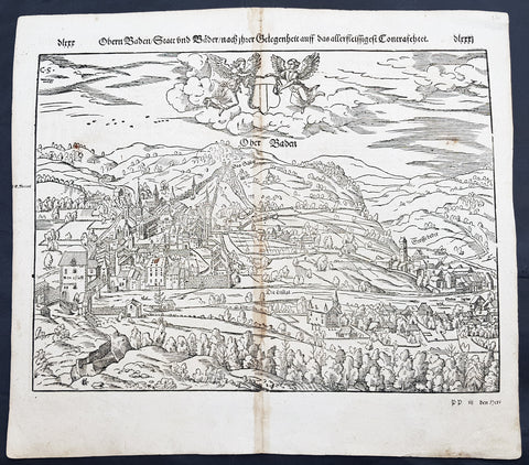
1598 Munster Antique Map Birds Eye View of Baden bei Zürich, Aargau, Switzerland
- Title : Die Statt Baden
- Date : 1598
- Condition: (A) Very Good Condition
- Ref # : 30357
- Size : 15in x 13in (380mm x 340mm)
Description:
This fine original wood block engraved antique map a birds eye view of the Swiss city of Baden bei Zürich on the Limmat River in the Canton of Aargau was published in the German Section of Sebastian Munsters 1598 edition of Cosmographia, Das ist: Beschreibung der gantzen Welt, Darinnen Aller Monarchien Keyserthumben, Königreichen, Fürstenthumben, Graff- und Herrschafften, Länderen, Stätten und Gemeinden.Ursprung (Cosmographia, that is: description of the whole world, in it all monarchies Keyser thumben, kingdoms, prince thumben, graff and herrschafften, countries, places and municipalities.)
Baden sometimes unofficially, to distinguish it from other Badens, called Baden bei Zürich (Baden near Zürich) or Baden im Aargau (Baden in Aargau) is a municipality in Switzerland. It is the seat of the district of Baden in the canton of Aargau. Located 25 km northwest of Zürich in the Limmat Valley (Limmattal) mainly on the western side of the Limmat, its mineral hot springs have been famed since at least the Roman era.
Baden is first attested in Roman sources as Aquae Helveticae (Waters of the Helvetii). Hippocrates had counseled against the use of water from mineral springs, but by the time of Vitruvius, Pliny, and Galen they were being selectively employed for certain ailments. In addition to their medical use, the Romans also revered natural springs for recreational and religious use. Tacitus mentions the town obliquely, describing it as a place built up into a semblance of a town... much used for its healthful waters. This Roman vicus was to the north of the Baden gorge on the Haselfeld, founded to support the legionary camp at Vindonissa. There was a pool complex on the left bank of the Limmat fed by a system of springs with 47 °C water. The main axis of the vicus was the Vindonissa road, which ran parallel to the slope. It was flanked by porticos, beyond which lay commercial and residential buildings. The center of the settlement had some wealthy villa-like structures. The resort, residential, and commercial districts all grew to a respectable size over the first half of the 1st century. In ad 69, however, the 21st Legion burned the town amid the conflicts of the Year of the Four Emperors. Its wooden buildings destroyed, the town was rebuilt in stone. The town shrank some after the closing of the Vinonissa camp in ad 101 but survived on trade. Reginus\'s pottery workshop and Gemellianus\'s bronze works flourished during the second half of the 2nd century Around the middle of the 3rd century, however, the settlement was threatened by multiple Alemanni invasions and the Huns. The pools were fortified and a large number of coins stamped with references to the hot springs show it continued to be settled and frequented into late antiquity, but expansion of the settlement of Haselfeld came to an end.
The baths were frequented again by the time of Charlemagne. A medieval necropolis in Kappelerhof has been dated as far back as the 7th century and a local lord fortifying the Stein by the 10th. The modern name Baden is first attested in 1040. Around that time, its land was held by the Lenzburgs, some of whom styled themselves as the Counts of Baden in the 12th century and erected a castle. Upon their extinction around 1172, their domains were divided among the Hohenstaufens, Zähringens, and Kyburgs, with the Kyburgs gaining control of Baden through the marriage of Harmanns III with its heiress Richenza. Around 1230, they founded the medieval city of Baden, holding markets and erecting a bridge across the river in 1242. Upon the death of the childless Hartman IV in 1264, his lands were seized by Rudolf von Habsburg by right of his wife Gertrude\'s claim. Stein Castle was held by Habsburg bailiffs and maintained the administration and archives for their surrounding territory. The Confederation besieged and destroyed the castle and its records in 1415 during its conquest of Aargau. Thus, the County of Baden was established.
Under the Confederation, their bailiff held a castle on the right bank of the Limmat, controlling access to the bridge. The Swiss Diet met at Baden repeatedly from 1426 to about 1712, making Baden a kind of capital for Switzerland. The Town Hall (Rathaus) where it met is beautifully carved and can still be visited. Over the course of the 15th century, the town regained its popularity as a Spa Resort (Kurort). The town was the site of a famous debate on transubstantiation from May 21 to June 18, 1526. Although Zwingli refused to attend in person, he printed broadsheets throughout its duration and sent his assistant Johann Oecolampadius to debate Johann Eck and Thomas Murner. In the end, a majority decided against the reformers but a substantial bloc emerged on their behalf as well. Johann Pistorius held a disputation in the city in 1589. Stein was refortified sometime between 1658 and 1670 but the fortress was abandoned in 1712. In 1714, the treaties of Rastatt and Baden ended hostilities between France and the Habsburgs, the last theater of the War of the Spanish Succession. Another Treaty of Baden ended the Toggenburg War among the Protestant and Catholic Swiss cantons in 1718. Baden was the capital of the canton of Baden from 1798 until 1803, when the canton of Aargau was created.
In the 19th century, the waters were considered efficacious for gout and rheumatism. They were frequented by Goethe, Nietzsche, Thomas Mann, and particularly often by Hermann Hesse, who visited the town annually over almost thirty years. The SNB connecting Zürich to Baden was Switzerland\'s first railway, opening in 1847. Prior to the First World War, foreign visitors were few in number, but the summer tourist season was thought to swell the town. Around the same time, an industrial quarter opened up NW of the baths
General Definitions:
Paper thickness and quality: - Heavy and stable
Paper color : - off white
Age of map color: -
Colors used: -
General color appearance: -
Paper size: - 15in x 13 1/4in (380mm x 340mm)
Plate size: - 15in x 13 1/4in (380mm x 340mm)
Margins: - Min 1/4in (3mm)
Imperfections:
Margins: - None
Plate area: - Age toning along centerfold
Verso: - Age toning along centerfold, light soiling
Background:
Cosmographia, Das ist: Beschreibung der gantzen Welt, Darinnen Aller Monarchien Keyserthumben, Königreichen, Fürstenthumben, Graff- und Herrschafften, Länderen, Stätten und Gemeinden.Ursprung, Regiment, Reichthumb, Gewalt und.Beschaffenheit. Dessgleichen Aller deren, beyder Ständen, Regenten: Keysern, Königen, Bäpsten, Bischoffen.Genealogien und Stammbäumen.zusammen getragen. by Sebastian Münster was first published in 1544 and is the earliest German-language description of the world. It had numerous editions in different languages including Latin, French (translated by François de Belleforest), Italian, English, and Czech. The last German edition was published in 1628, long after Munsters death. The Cosmographia was one of the most successful and popular books of the 16th century. It passed through 24 editions in 100 years. This success was due to the notable woodcuts (some by Hans Holbein the Younger, Urs Graf, Hans Rudolph Manuel Deutsch, and David Kandel). It was most important in reviving geography in 16th-century Europe. Among the notable maps within Cosmographia is the map Tabula novarum insularum, which is credited as the first map to show the American continents as geographically discrete.
Munsters earlier geographic works were Germania descriptio (1530) and Mappa Europae (1536). In 1540, he published a Latin edition of Ptolemys Geographia with illustrations.