
Sebastian Munster (1489 - 1552)
Profile :
After Waldseemuller three names dominated cartography in the 16th century; Mercator, Ortelius & Munster, and of these three Munster probably had the widest influence in spreading geographical knowledge throughout Europe in the middle years of the century. His Cosmographica, issued in 1544, contained not only the latest views of many well known cities, but included an encyclopedic amount of detail about the known – and unknown – world and undoubtedly must have been one of the most widely read books of its time, going through nearly forty editions in six languages.
An eminent German mathematician and linguist, Munster became professor of Hebrew at Heidelberg and later at Basle, where he settled in 1529. In 1528, following his first mapping of Germany, he appealed to German scholars to send him descriptions, so that all Germany with its villages, towns, trades etc. may be seen in a `mirror`, even going so far as to give instructions on how they should map their own localities. The response was far greater than expected and much information was sent by foreigners as well as Germans so that, eventually, he was able to include many up-to-date, if not very accurate, maps in his atlases. He was the first to provide a separate map of each of the four known continents and the first separately printed map of England. His maps, printed from woodblocks, are now greatly valued by collectors. His two major works, the Geographia and Cosmographia were published in Basle by his sep-son, Henri Petri, who continued to issue many editions after Munsters death of the plague in 1552.
Munster’s dominance of the cartographic market was relatively short lived once Ortelius produced his “Theatrum Orbis Terrarum” in 1570. Munster's somewhat naive engravings of the world, continents and countries were revised and re-published by Sebastian Petri with more sophisticated maps in 1588, using the Ortelius Atlas as a guide. In Munsters defense though, he had little in the way of examples or reference to help produce what was the first comprehensive atlas of the known world.
Sebastian Munster'sGeographia (first published in 1540) and his later Cosmographia (first published in 1544) were cartographic landmarks. TheGeographia included not only Ptolemaic maps, but also a number of landmark modern maps, including the first separate maps of the 4 continents, the first map of England and the earliest obtainable map of Scandinavia. The Cosmographia was the earliest German description of the world and a major work in the revival of geographic thought in 16th-century Europe. Altogether, about 40 editions of the Cosmographia appeared between 1544 and 1628.
Munster dominated cartographic publication during the mid-16th Century and is generally regarded as one of the important map makers of the 16th Century. Originally a scholar studying Hebrew, Greek and mathematics, Munster (1489-1552) eventually specialised in mathematical geography and cartography. He is best known for his edition of the Geographia, a translation of Ptolemy's landmark geographical text. Munster's version is illustrated with maps based on Ptolemy's calculations, but also, in recognition of the increased geographical awareness of the period, contains a section of modern maps including the first set of maps of each continent. In the first edition of the Geographia, Munster included twenty-seven ancient Ptolemaic maps and twenty-one modern maps, printed from woodblocks. Subsequent editions of the Cosmographia much expanded his Geographia and contained a vast number of maps and plans.
Sebastian Munster (3)
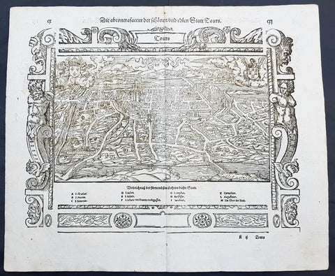
1574 Munster Large Antique Print View of The French City of Tours
- Title : Die Statt Tours
- Ref #: 22614
- Size: 16in x 13in (410mm x 330mm)
- Date : 1574
- Condition: (A+) Fine Condition
Description:
This large finely engraved original antique print a view of the French city of Tours was published by Sebastian Munster in the 1574 edition of Cosmographia.
Tours is a city located in the centre-west of France. It is the administrative centre of the Indre-et-Loire department and the largest city in the Centre-Val de Loire region of France (although it is not the capital, which is the region's second-largest city, Orléans). Tours stands on the lower reaches of the River Loire, between Orléans and the Atlantic coast. The surrounding district, the traditional province of Touraine, is known for its wines, for the alleged perfection (as perceived by some speakers) of its local spoken French, and for the Battle of Tours (732).
Background: For a variety of reasons town plans were comparatively latecomers in the long history of cartography. Few cities in Europe in the middle ages had more than 20,00 inhabitants and even London in the late Elizabethan period had only 100-150,000 people which in itself was probably 10 times that of any other English city. The Nuremberg Chronicle in 1493 included one of the first town views of Jerusalem, thereafter, for most of the sixteenth century, German cartographers led the way in producing town plans in a modern sense. In 1544 Sebastian Munster issued in Basle hisCosmographia containing roughly sixty-six plans and views, some in the plan form, but many in the old panorama or birds eye view.
Sebastian Münster (1488-1552) was a German cartographer, cosmographer, and Hebrew scholar whose work Cosmographia (1544; "Cosmography") was the earliest German description of the world and a major work in the revival of geographic thought in 16th-century Europe. It had numerous editions in different languages including Latin, French, Italian, English, and even Czech. Altogether, about 40 editions of the Cosmographiaappeared between 1544 and 1628 and was one of the most successful and popular books of the 16th century. Münster was a major influence in popular thinking in Europe for the next 200 years.
This success was due not only to the level of descriptive detail but also to the fascinating full page maps & views as well as smaller woodcuts that were included in the text. Many of the woodcuts were executed by famous engravers of the time including Hans Holbein the Younger, Urs Graf, Hans Rudolph Manuel Deutsch, and David Kandel.
Aside from the well-known maps present in the Cosmographia, the text is thickly sprinkled with vigorous views: portraits of kings and princes, costumes and occupations, habits and customs, flora and fauna, monsters, wonders, and horrors about the known -- and unknown -- world, and was undoubtedly one of the most widely read books of its time.
Münster acquired the material for his book in three ways. Firstly he researched all available literary sources across Germany, Switzerland and other parts of Europe. Secondly he obtained original manuscript material from locals all over Europe for description of the countryside, cities, villages, towns, rivers and local history. Finally, he obtained further material first hand on his travels (primarily in south-west Germany, Switzerland, and Alsace).
In 1588 Sebastian Petri re-released Cosomgraphia and re-issued many of Munsters maps and views in the "copperplate style". The maps in this release were more sophisticated than with earlier publications ofCosomgraphia and were based on the 1570 release of Abraham Ortelius monumental work Theatrum Orbis Terrarum.(Ref: Tooley; M&B)
General Description:
Paper thickness and quality: - Light and stable
Paper color: - off white
Age of map color: -
Colors used: -
General color appearance: -
Paper size: - 16in x 13in (410mm x 330mm)
Plate size: - 16in x 13in (410mm x 330mm)
Margins: - 1/2in (12mm)
Imperfections:
Margins: - None
Plate area: -None
Verso: - None

1574 Sebastian Munster Antique Map Birds Eye View of the City of Tours, France
- Title : Die Statt Tours
- Ref #: 22614
- Size: 16in x 13in (410mm x 330mm)
- Date : 1574
- Condition: (A+) Fine Condition
Description:
This fine original wood block engraved antique map a birds eye view of the French city of Tours, France was published in the French Section of Sebastian Munsters 1574 edition of Cosmographia, Das ist: Beschreibung der gantzen Welt, Darinnen Aller Monarchien Keyserthumben, Königreichen, Fürstenthumben, Graff- und Herrschafften, Länderen, Stätten und Gemeinden.Ursprung (Cosmographia, that is: description of the whole world, in it all monarchies Keyser thumben, kingdoms, prince thumben, graff and herrschafften, countries, places and municipalities.)
Tours is a city in the centre-west of France. It is the administrative centre of the Indre-et-Loire department and the largest city in the Centre-Val de Loire region of France
General Definitions:
Paper thickness and quality: - Heavy and stable
Paper color : - off white
Age of map color: -
Colors used: -
General color appearance: -
Paper size: - 16in x 13in (410mm x 330mm)
Plate size: - 16in x 13in (410mm x 330mm)
Margins: - Min 1in (25mm)
Imperfections:
Margins: - None
Plate area: - None
Verso: - None
Background:
Cosmographia, Das ist: Beschreibung der gantzen Welt, Darinnen Aller Monarchien Keyserthumben, Königreichen, Fürstenthumben, Graff- und Herrschafften, Länderen, Stätten und Gemeinden.Ursprung, Regiment, Reichthumb, Gewalt und.Beschaffenheit. Dessgleichen Aller deren, beyder Ständen, Regenten: Keysern, Königen, Bäpsten, Bischoffen.Genealogien und Stammbäumen.zusammen getragen. by Sebastian Münster was first published in 1544 and is the earliest German-language description of the world. It had numerous editions in different languages including Latin, French (translated by François de Belleforest), Italian, English, and Czech. The last German edition was published in 1628, long after Munsters death. The Cosmographia was one of the most successful and popular books of the 16th century. It passed through 24 editions in 100 years. This success was due to the notable woodcuts (some by Hans Holbein the Younger, Urs Graf, Hans Rudolph Manuel Deutsch, and David Kandel). It was most important in reviving geography in 16th-century Europe. Among the notable maps within Cosmographia is the map Tabula novarum insularum, which is credited as the first map to show the American continents as geographically discrete.
Munsters earlier geographic works were Germania descriptio (1530) and Mappa Europae (1536). In 1540, he published a Latin edition of Ptolemys Geographia with illustrations.
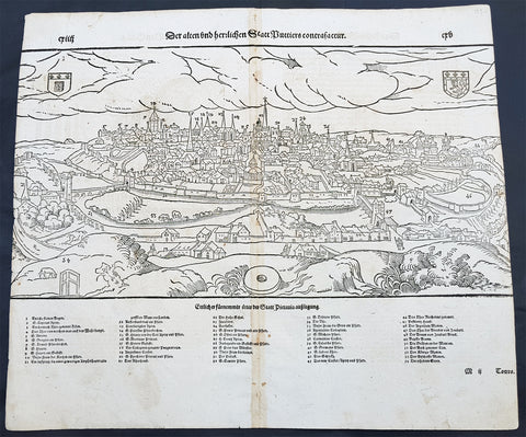
1598 Munster Antique Map Birds Eye View of the city of Poitiers in Poitou France
- Title : Die Statt Puttiers
- Date : 1598
- Condition: (A) Very Good Condition
- Ref # : 30381
- Size : 15in x 13in (380mm x 340mm)
Description:
This fine original wood block engraved antique map a birds eye view of the French city of Poitiers on the Clain River in the Vienne Dept of central western France, was published in the French Section of Sebastian Munsters 1598 edition of Cosmographia, Das ist: Beschreibung der gantzen Welt, Darinnen Aller Monarchien Keyserthumben, Königreichen, Fürstenthumben, Graff- und Herrschafften, Länderen, Stätten und Gemeinden.Ursprung (Cosmographia, that is: description of the whole world, in it all monarchies Keyser thumben, kingdoms, prince thumben, graff and herrschafften, countries, places and municipalities.)
Poitiers is a city on the Clain river in west-central France. It is a commune and the capital of the Vienne department and also of the Poitou.
The type of political organisation existing in Poitiers during the late medieval or early modern period can be glimpsed through a speech given on 14 July 1595 by Maurice Roatin, the town\'s mayor. He compared it to the Roman state, which combined three types of government: monarchy (rule by one person), aristocracy (rule by a few), and democracy (rule by the many). He said the Roman consulate corresponded to Poitiers\' mayor, the Roman senate to the town\'s peers and échevins, and the democratic element in Rome corresponded to the fact that most important matters can not be decided except by the advice of the Mois et Cent (broad council).1 The mayor appears to have been an advocate of a mixed constitution; not all Frenchmen in 1595 would have agreed with him, at least in public; many spoke in favour of absolute monarchy. The democratic element was not as strong as the mayor\'s words may seem to imply: in fact, Poitiers was similar to other French cities, Paris, Nantes, Marseille, Limoges, La Rochelle, Dijon, in that the town\'s governing body (corps de ville) was highly exclusive and oligarchical: a small number of professional and family groups controlled most of the city offices. In Poitiers many of these positions were granted for the lifetime of the office holder.
The city government in Poitiers based its claims to legitimacy on the theory of government where the mayor and échevins held jurisdiction of the citys affairs in fief from the king: that is, they swore allegiance and promised support for him, and in return he granted them local authority. This gave them the advantage of being able to claim that any townsperson who challenged their authority was being disloyal to the king. Every year the mayor and the 24 échevins would swear an oath of allegiance between the hands of the king or his representative, usually the lieutenant général or the sénéchaussée. For example, in 1567, when Maixent Poitevin was mayor, king Henry III came for a visit, and, although some townspeople grumbled about the licentious behaviour of his entourage, Henry smoothed things over with a warm speech acknowledging their allegiance and thanking them for it.
In this era, the mayor of Poitiers was preceded by sergeants wherever he went, consulted deliberative bodies, carried out their decisions, heard civil and criminal suits in first instance, tried to ensure that the food supply would be adequate, visited markets.
In the 16th century, Poitiers impressed visitors because of its large size, and important features, including royal courts, university, prolific printing shops, wealthy religious institutions, cathedral, numerous parishes, markets, impressive domestic architecture, extensive fortifications, and castle.
16th-century Poitiers is closely associated with the life of François Rabelais and with the community of Bitards.
The town saw less activity during the Renaissance. Few changes were made in the urban landscape, except for laying way for the rue de la Tranchée. Bridges were built where the inhabitants had used gués. A few hôtels particuliers were built at that time, such as the hôtels Jean Baucé, Fumé and Berthelot. Poets Joachim du Bellay and Pierre Ronsard met at the University of Poitiers, before leaving for Paris.
During the 17th century, many people emigrated from Poitiers and the Poitou to the French settlements in the new world and thus many Acadians or Cajuns living in North America today can trace ancestry back to this region.
General Definitions:
Paper thickness and quality: - Heavy and stable
Paper color : - off white
Age of map color: -
Colors used: -
General color appearance: -
Paper size: - 15in x 13 1/4in (380mm x 340mm)
Plate size: - 15in x 13 1/4in (380mm x 340mm)
Margins: - Min 1/4in (3mm)
Imperfections:
Margins: - L&R margins cropped into border
Plate area: - Light toning along centerfold
Verso: - Light toning along centerfold
Background:
Cosmographia, Das ist: Beschreibung der gantzen Welt, Darinnen Aller Monarchien Keyserthumben, Königreichen, Fürstenthumben, Graff- und Herrschafften, Länderen, Stätten und Gemeinden.Ursprung, Regiment, Reichthumb, Gewalt und.Beschaffenheit. Dessgleichen Aller deren, beyder Ständen, Regenten: Keysern, Königen, Bäpsten, Bischoffen.Genealogien und Stammbäumen.zusammen getragen. by Sebastian Münster was first published in 1544 and is the earliest German-language description of the world. It had numerous editions in different languages including Latin, French (translated by François de Belleforest), Italian, English, and Czech. The last German edition was published in 1628, long after Munsters death. The Cosmographia was one of the most successful and popular books of the 16th century. It passed through 24 editions in 100 years. This success was due to the notable woodcuts (some by Hans Holbein the Younger, Urs Graf, Hans Rudolph Manuel Deutsch, and David Kandel). It was most important in reviving geography in 16th-century Europe. Among the notable maps within Cosmographia is the map Tabula novarum insularum, which is credited as the first map to show the American continents as geographically discrete.
Munsters earlier geographic works were Germania descriptio (1530) and Mappa Europae (1536). In 1540, he published a Latin edition of Ptolemys Geographia with illustrations.