
Recent Acquisitions (6)
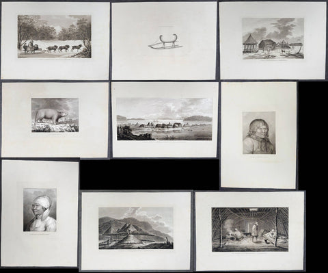
1784 James Cook 9 x Antique 1st Edition Prints of Petropavlovsk-Kamchatsky, Kamchatka Russia, 1779
Antique Print
- Title : A Man of Kamtschatka, Travelling in Winter; A Sledge of Kamtschatka; A View at Bolcheretzkoi, in Kamtschatka; A White Bear; A View of the Town and Harbour of St Peter and St Paul, in Kamtschatka; A Man of Kamtschatka; A Woman of Kamtschatka; Summer and Winter Habitations in Kamtschatka; The Inside of a Winter Habitation in Kamtschatka.
- Ref : 61231; 61273; 61232; 61233; 61274; 61234; 61235; 61236; 61275.
- Size: 21in x 15 1/2in (535mm x 395mm)
- Date : 1784
- Condition: (A+) Fine Condition
Description:
This scarce, complete set of nine first-edition large antique prints (Plates #70 through #78) represents the entire visual record from the third expedition's historic visit to Kamchatka, Siberia. These illustrations were captured during the spring and summer of 1779 during the crew's second, unsuccessful attempt to locate the elusive Northwest Passage following Captain James Cook's tragic death. The original drawings by John Webber (Cooks official onboard artist) were expertly engraved by Samuel Middleman; Thomas Goodyer; Paul Benezech; Peter Mazell; B T Pouncy; William Sharp; Samuel Smith; William Sharp respectively for the official, British Admiralty-sanctioned account of Cooks third and final journey: "A Voyage to the Pacific Ocean... In Three Volumes. Vol. I & II and Atlas, written by James Cook & Capt J Clerk, F.R.S. Vol. III in London, 1784.
In 1778 the expedition had surveyed the North American coast from Nootka Sound to Alaska, passed through the Bering Strait, and been turned back by pack ice off Icy Cape in August. They then wintered in Hawaii, where Cook was killed in February 1779.
The expedition returned to the NW American coast on 29 April 1779, under Charles Clerke and John Gore, and stayed until 16 June. The Russians at the settlement of St Peter and St Paul (now Petropavlovsk-Kamchatsky) helped with provisions and repairs and forwarded the expedition's dispatches, and Webber drew the settlement in "A View of the Town and Harbour of St Peter and St Paul, in Kamtschatka." Officers, including James King and Webber, also travelled to Bolcheretzkoi (now Bolsheretsk), on Kamchatka's west coast, to meet the Russian commandant, Major Behm, which is the subject of "A View at Bolcheretzkoi, in Kamtschatka." Webber's studies of the people he met became "A Man of Kamtschatka" and "A Woman of Kamtschatka" (Kamtschatka being the spelling of Kamchatka used in 1784), and his drawings of how they lived became "Summer and Winter Habitations in Kamtschatka" and "The Inside of a Winter Habitation in Kamtschatka." Winter travel, which the crews saw in the local dog teams, appears in "A Sledge of Kamtschatka" and "A Man of Kamtschatka, Travelling in Winter."
The ships left on 16 June for a second, failed attempt on the Arctic ice, and "A White Bear" recalls those northern waters. Clerke died on 22 August, and the ships were back at Petropavlovsk by 24 August, where he was buried. Webber's panoramic drawing of the town dates from late August and early September 1779.
The ships finally left Kamchatka in October, bound for Macau and home.
Exceptional and highly sought-after large museum quality prints, perfect for collectors of Captain Cook history, maritime art, and early Australian, Pacific, American & Polar exploration.
General Definitions:
Paper thickness and quality: - Heavy and stable
Paper color : - off white
Age of map color: -
Colors used: -
General color appearance: -
Paper size: - 21in x 15 1/2in (535mm x 395mm)
Plate size: - Various sizes please see below in background for individual sizes.
Margins: - Min 2in (50mm)
Imperfections:
Margins: - Light creasing
Plate area: - None
Verso: - Light creasing
Background:
Captain James Cook's third and final voyage (1776–1780) set out from Plymouth to search for a Northwest Passage between the Pacific and Atlantic, sailing via the Cape of Good Hope and the Kerguelen Islands before visiting Tasmania and New Zealand and threading through the Pacific islands — Tonga, Tahiti, and the Society Islands — over the course of 1777. In January 1778 Cook became the first European to reach the Hawaiian Islands, which he named the Sandwich Islands, and from there sailed to the west coast of North America, charting the coastline from Oregon up through Nootka Sound, Unalaska (Alaska), and the Bering Strait into the Arctic Ocean, where pack ice forced him to turn back in August 1778. He wintered in Hawaii, anchoring at Kealakekua Bay in January 1779, where a dispute with islanders turned violent and Cook was killed on 14 February 1779. Command passed to Charles Clerke, who made one more unsuccessful attempt at the Northwest Passage before the expedition sailed home via Kamchatka Peninsula (Russia) , Macau, and the Cape of Good Hope, finally reaching England in October 1780.
Captain James Cook's third and final voyage A Voyage to the Pacific Ocean... In Three Volumes. Vol. I & II and Atlas, was illustrated in the original 1784/5 atlas containing 2 maps and 61 prints, engraved after John Webber's drawings (Cooks official artist on the voyage) by various engravers. Below is each location visited by Cook and later Capt. Clerk with the dates and corresponding prints.
Kerguelen Islands (Christmas Harbour) — 25 December 1776
• Plate 4 — A View of Christmas Harbour, in Kerguelen's Land
Van Diemen's Land (Tasmania), Adventure Bay — January 1777
• Plate 6 — A man of Van Diemen's Land
• Plate 7 — A woman of Van Diemen's Land
• Plate 8 — An opossum of Van Diemen's Land
Queen Charlotte Sound, New Zealand — February 1777
• Plate 10 — The Inside of a Hippah in New Zeeland
Mangaia, Cook Islands — March–April 1777
• Plate 11 — A man of Mangea
Tongan (Friendly) Islands — April–July 1777
• Plate 13 — A view at Anamooka
• Plate 14 — The reception of Captain Cook, in Hapaee
• Plate 15 — A boxing match, in Hapaee
• Plate 16 — A night dance by men, in Hapaee
• Plate 17 — A night dance by women, in Hapaee
• Plate 18 — Poulaho, King of the Friendly Islands
• Plate 20 — Poulaho, King of the Friendly Islands, drinking kava
• Plate 21 — A Fiatooka (Morai), in Tongataboo
• Plate 22 — The Natche, a ceremony in Tongataboo
• Plate 23 — A woman of Eaoo
Tahiti (Otaheite) — August 1777
• Plate 25 — A human sacrifice, in a marai
• Plate 26 — The body of Tee, a chief, as preserved after death
• Plate 27 — A young woman of Otaheite, bringing a present
• Plate 28 — A dance in Otaheite
• Plate 29 — A young woman of Otaheite, dancing
Huahine, Society Islands — October–November 1777
• Plate 31 — A view of Huaheine
Christmas Island (Kiritimati) — December 1777
• Discovered on this leg of the voyage; not separately plated
Kauai (Atooi), Hawaiian Islands — January 1778 (first European landfall in Hawaii) • Plate 33 — A Morai, in Atooi
• Plate34 — The inside of the house, in the Morai
• Plate 35 — An inland view, in Atooi
Nootka Sound, Vancouver Island — March–April 1778
• Plate 38 — A man of Nootka Sound
• Plate 39 — A woman of Nootka Sound
• Plate 40 — Various articles, at Nootka Sound
• Plate 41 — A view of the habitation in Nootka Sound
• Plate 42 — The inside of a house in Nootka Sound
• Plate 43 — A sea otter
Prince William Sound, Alaska — May 1778
• Plate 45 — A view of Snug Corner, in Prince William Sound
• Plate 46 — A man of Prince William Sound
• Plate 47 — A woman of Prince William Sound
Unalaska (Oonalashka) — June and October 1778
• Plate 48 — A man of Oonalashka
• Plate 49 — A woman of Oonalashka
• Plate 50 — Canoes of Oonalashka
• Plate 56 — Caps of the natives of Oonalashka
• Plate 57 — Natives of Oonalashka, and their habitations
• Plate 58 — The inside of a house, in Oonalashka
Norton Sound and the Chukchi Coast, Siberia — August 1778
• Plate 51 — The Tschuktschi, and their habitations
• Plate 54 — Inhabitants of Norton Sound and their habitations
Arctic Ocean, near the Bering Strait — August 1778 (Cook turned back by ice)
• Plate 52 — Sea horses (walruses)
Kealakekua Bay, Hawaii (Owyhee) — January–February 1779 (Cook killed 14 February 1779)
• Plate 60 — An offering before Captain Cook, in the Sandwich Islands
• Plate 61 — Tereoboo, King of Owyhee, bringing presents to Captain Cook
• Plate 62 — A man of the Sandwich Islands, dancing
• Plate 63 — A young woman of the Sandwich Islands
• Plate 64 — A man of the Sandwich Islands, with his helmet
• Plate 65 — A canoe of the Sandwich Islands, the rowers masked
• Plate 66 — A man of the Sandwich Islands, in a mask
• Plate 67 — Various articles, at the Sandwich Islands
• Plate 68 — A view of Karakakooa, in Owyhee
Kamchatka, St Peter and St Paul Harbour (Petropavlovsk) — spring and summer 1779
• Plate 70 — A man of Kamtschatka, travelling in winter - 16in x 10in (405mm x 255mm)
• Plate 71 — A sledge of Kamtschatka - 10in x 7 1/2in (255mm x 190mm)
• Plate 72 — A view at Bolcheretzkoi, in Kamtschatka - 13 1/2in x 9 1/2in (345mm x 240mm)
• Plate 73 — A white bear - 10 1/2in x 8 1/2in (265mm x 215mm)
• Plate 74 — A view of the town and harbour of St Peter and St Paul - 20 1/2in x 10in (520mm x 255mm)
• Plate 75 — A man of Kamtschatka - 12in x 9 1/2in (305mm x 240mm)
• Plate 76 — A woman of Kamtschatka - 12in x 9 1/2in (305mm x 240mm)
• Plate 77 — Summer and winter habitations, in Kamtschatka - 16in x 9 1/2in (405mm x 240mm)
• Plate 78 — The inside of a winter habitation in Kamtschatka - 16 1/2in x 10in (420mm x 255mm)
Return to England — October 1780
John Webber (1751–1793) was a Swiss-born British artist who served as the official expedition artist on Cook's third voyage, tasked with visually documenting the peoples, landscapes, and events the ships encountered. His drawings — later engraved as the 61 plates in the atlas accompanying the 1784 official account — provided some of the first detailed European depictions of Hawaii, the Pacific Northwest coast, and other Pacific and Arctic locales, including the scene of Cook's death at Kealakekua Bay. Webber was elected a full Royal Academician in 1791 and continued to exhibit landscape work until his death in 1793.
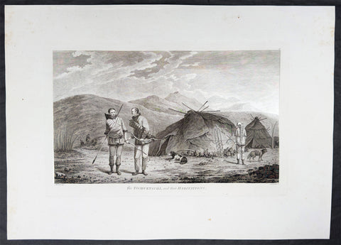
1784 James Cook & John Webber Antique 1st Edition Print Village in Chukotski Peninsula, Siberia , 1778
Antique Print
- Title : The Tschuktschi, and their Habitations
- Ref : 61228
- Size: 21 3/4in x 15 1/2in (550mm x 395mm)
- Date : 1784
- Condition: (A) Very Good Condition
Description:
This scarce first-edition large antique print, plate #51, the only plate illustrating the Chukotski Peninsula in Siberia, of a view of a Chukotski Village & its inhabitants in August 1778, was drawn by John Webber (Cooks official onboard artist) and expertly engraved by Daniel Lerpiniere for the official, British Admiralty-sanctioned account of Cooks journey: "A Voyage to the Pacific Ocean... In Three Volumes. Vol. I & II and Atlas, written by James Cook & Capt J Clerk, F.R.S. Vol. III in London, 1784.
In the summer of 1778, Cook's search for the Northwest Passage took him to both sides of the Bering Strait. He landed on the Chukotski Peninsula in Siberia on 10 August and met the Chukchi, who welcomed his party, and the two sides traded European knives, beads and tobacco for Chukchi clothes, gloves and arrows. Though the visit lasted only a few hours, Webber sketched their clothing, dogs and dome-shaped summer huts, and these became the plate "The Tschuktschi, and their Habitations".
The ships then passed north through the strait on 11 August. Pack ice stopped them off Alaska on 18 August, at about 70°N, and Cook spent the next eleven days working westward along the ice edge before reaching the Siberian coast again on 29 August. He gave up the search then and sailed south through the strait on 2 September. Turning to the Alaskan side, he explored the inlet he named Norton Sound after Sir Fletcher Norton, Speaker of the House of Commons, naming Cape Denbigh on 11 September and Besborough Island on 12 September. Like the Siberian coast, it offered no way through, since Norton Sound proved a shallow gulf and not a passage. Webber's plate of a family with their shelter and kayak is the main record of the people there. Cook then sailed for Unalaska and, after repairs, south to Hawaii for the winter.
Exceptional and highly sought-after large museum quality prints, perfect for collectors of Captain Cook history, maritime art, and early Australian, Pacific & Polar exploration.
General Definitions:
Paper thickness and quality: - Heavy and stable
Paper color : - off white
Age of map color: -
Colors used: -
General color appearance: -
Paper size: - 21 3/4in x 15 1/2in (550mm x 395mm)
Plate size: - 16in x 10in (405mm x 255mm)
Margins: - Min 2in (50mm)
Imperfections:
Margins: - Light creasing
Plate area: - Light creasing
Verso: - Light creasing
Background:
Captain James Cook's third and final voyage (1776–1780) set out from Plymouth to search for a Northwest Passage between the Pacific and Atlantic, sailing via the Cape of Good Hope and the Kerguelen Islands before visiting Tasmania and New Zealand and threading through the Pacific islands — Tonga, Tahiti, and the Society Islands — over the course of 1777. In January 1778 Cook became the first European to reach the Hawaiian Islands, which he named the Sandwich Islands, and from there sailed to the west coast of North America, charting the coastline from Oregon up through Nootka Sound, Unalaska (Alaska), and the Bering Strait into the Arctic Ocean, where pack ice forced him to turn back in August 1778. He wintered in Hawaii, anchoring at Kealakekua Bay in January 1779, where a dispute with islanders turned violent and Cook was killed on 14 February 1779. Command passed to Charles Clerke, who made one more unsuccessful attempt at the Northwest Passage before the expedition sailed home via Kamchatka Peninsula (Russia) , Macau, and the Cape of Good Hope, finally reaching England in October 1780.
Captain James Cook's third and final voyage A Voyage to the Pacific Ocean... In Three Volumes. Vol. I & II and Atlas, was illustrated in the original 1784/5 atlas containing 2 maps and 61 prints, engraved after John Webber's drawings (Cooks official artist on the voyage) by various engravers. Below is each location visited by Cook and later Capt. Clerk with the dates and corresponding prints.
Kerguelen Islands (Christmas Harbour) — 25 December 1776
• Plate 4 — A View of Christmas Harbour, in Kerguelen's Land
Van Diemen's Land (Tasmania), Adventure Bay — January 1777
• Plate 6 — A man of Van Diemen's Land
• Plate 7 — A woman of Van Diemen's Land
• Plate 8 — An opossum of Van Diemen's Land
Queen Charlotte Sound, New Zealand — February 1777
• Plate 10 — The Inside of a Hippah in New Zeeland
Mangaia, Cook Islands — March–April 1777
• Plate 11 — A man of Mangea
Tongan (Friendly) Islands — April–July 1777
• Plate 13 — A view at Anamooka
• Plate 14 — The reception of Captain Cook, in Hapaee
• Plate 15 — A boxing match, in Hapaee
• Plate 16 — A night dance by men, in Hapaee
• Plate 17 — A night dance by women, in Hapaee
• Plate 18 — Poulaho, King of the Friendly Islands
• Plate 20 — Poulaho, King of the Friendly Islands, drinking kava
• Plate 21 — A Fiatooka (Morai), in Tongataboo
• Plate 22 — The Natche, a ceremony in Tongataboo
• Plate 23 — A woman of Eaoo
Tahiti (Otaheite) — August 1777
• Plate 25 — A human sacrifice, in a marai
• Plate 26 — The body of Tee, a chief, as preserved after death
• Plate 27 — A young woman of Otaheite, bringing a present
• Plate 28 — A dance in Otaheite
• Plate 29 — A young woman of Otaheite, dancing
Huahine, Society Islands — October–November 1777
• Plate 31 — A view of Huaheine
Christmas Island (Kiritimati) — December 1777
• Discovered on this leg of the voyage; not separately plated
Kauai (Atooi), Hawaiian Islands — January 1778 (first European landfall in Hawaii) • Plate 33 — A Morai, in Atooi
• Plate34 — The inside of the house, in the Morai
• Plate 35 — An inland view, in Atooi
Nootka Sound, Vancouver Island — March–April 1778
• Plate 38 — A man of Nootka Sound
• Plate 39 — A woman of Nootka Sound
• Plate 40 — Various articles, at Nootka Sound
• Plate 41 — A view of the habitation in Nootka Sound
• Plate 42 — The inside of a house in Nootka Sound
• Plate 43 — A sea otter
Prince William Sound, Alaska — May 1778
• Plate 45 — A view of Snug Corner, in Prince William Sound
• Plate 46 — A man of Prince William Sound
• Plate 47 — A woman of Prince William Sound
Unalaska (Oonalashka) — June and October 1778
• Plate 48 — A man of Oonalashka
• Plate 49 — A woman of Oonalashka
• Plate 50 — Canoes of Oonalashka
• Plate 56 — Caps of the natives of Oonalashka
• Plate 57 — Natives of Oonalashka, and their habitations
• Plate 58 — The inside of a house, in Oonalashka
Norton Sound and the Chukchi Coast, Siberia — August 1778
• Plate 51 — The Tschuktschi, and their habitations
• Plate 54 — Inhabitants of Norton Sound and their habitations
Arctic Ocean, near the Bering Strait — August 1778 (Cook turned back by ice)
• Plate 52 — Sea horses (walruses)
Kealakekua Bay, Hawaii (Owyhee) — January–February 1779 (Cook killed 14 February 1779)
• Plate 60 — An offering before Captain Cook, in the Sandwich Islands
• Plate 61 — Tereoboo, King of Owyhee, bringing presents to Captain Cook
• Plate 62 — A man of the Sandwich Islands, dancing
• Plate 63 — A young woman of the Sandwich Islands
• Plate 64 — A man of the Sandwich Islands, with his helmet
• Plate 65 — A canoe of the Sandwich Islands, the rowers masked
• Plate 66 — A man of the Sandwich Islands, in a mask
• Plate 67 — Various articles, at the Sandwich Islands
• Plate 68 — A view of Karakakooa, in Owyhee
Kamchatka, St Peter and St Paul Harbour (Petropavlovsk) — spring and summer 1779
• Plate 70 — A man of Kamtschatka, travelling in winter
• Plate 71 — A sledge of Kamtschatka
• Plate 72 — A view at Bolcheretzkoi, in Kamtschatka
• Plate 73 — A white bear
• Plate 74 — A view of the town and harbour of St Peter and St Paul
• Plate 75 — A man of Kamtschatka
• Plate 76 — A woman of Kamtschatka
• Plate 77 — Summer and winter habitations, in Kamtschatka
• Plate 78 — The inside of a winter habitation in Kamtschatka
Return to England — October 1780
John Webber (1751–1793) was a Swiss-born British artist who served as the official expedition artist on Cook's third voyage, tasked with visually documenting the peoples, landscapes, and events the ships encountered. His drawings — later engraved as the 61 plates in the atlas accompanying the 1784 official account — provided some of the first detailed European depictions of Hawaii, the Pacific Northwest coast, and other Pacific and Arctic locales, including the scene of Cook's death at Kealakekua Bay. Webber was elected a full Royal Academician in 1791 and continued to exhibit landscape work until his death in 1793.
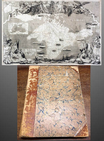
1853 - 1857 Elephant Folio Album w/ 328 Antique Maps & Prints of The Crimea War - Unique
Antique Map
- Title : Crimean War Maps, Prints & Views
- Date : 1853 - 57
- Size: 24in x 18in (610mm x 455mm) Elephant Folio
- Condition: (A) Very Good Condition
- Ref: 35600
Description:
This is a unique and very comprehensive visual record of the Crimean War (1853 - 1856 & 57) in a huge Elephant Folio Album.
The album consists of 163 double pages with 328 original maps, prints and views of the War tipped in chronological order. These are mainly from the Illustrated London News, from the Wars beginning in 1853 to its end in 1856 through to the Coronation of Alexander II in 1857 and some of the first recipients of the Victoria Cross.
My impression is that the album was professionally organised and assembled possibly by a political or historical organisation of the time, in the mid 19th century.
This album is extremely large measuring 28 inches x 18 inches (62cm x 46cm) when closed and weighs approx. 14 Kg.
The Album contains; (in more detail directly below)
- 71 views of various battles during the conflict.
- 94 Portraits & prints of the leaders, generals, & personnel who were in charge and soldiers, sailors who participated in the war.
- 47 views of various cities and towns from the participating countries England, Russia, Crimea, Turkey etc.
- 63 prints of naval fleets, battleships, sea battles, landings & evacuations..
- 15 Maps of various regions and conflicts
- 25 victory scenes in Britain
- 39 prints of portraits and views of the Coronation of Alexander II
- 4 Pages of recipients from both Army & Navy, of the first Victoria Cross.
Battle Views (Battle of Kars, Kinburn, Sebastopol, Malakoff, Tchernaya, Sveaborg, Gheisk, Hango-Head, Narva, Balaclava, Inkerman, Charge of Light Cavalry Balaclava, Alma, Odessa, Crondstat, Citate, Oltenitza, Kalafat)
Prints of leaders, generals and soldiers (British, Russian, Turkish, Greek, French, Austrian, Peace Talks Paris, Congress of Vienna, Allied Naval Command, Marshall Pelissier, Wounded, Hospitals, Sir De Lacy Evans, Nicolas Emperor of Russia, Royal Marines, Lord Raglan, Napoleon III, Commanders of Allied Armies in the East, Sultan of Turkey, Marshal St Arnaud, French Cavalry, French Infantry, British Infantry, British Navy, Sir Charles Napier, Rear Admiral Corry, & Plumridge, British Cavalry & Artillery Officers, Scots Guards, Royal marines, British Cavalry, Coldstream Guards, Grenadier Guards, Omer Pacha, General Prim)
Views of cities & towns (Balaclava, Kars, Sebastopol, Sveaborg, Helsingborg, Kiel, Copenhagen, Crondstat, St Petersberg, Kerch, Inkermann, Eupatoria, Alma, Coast of Crimea, Varna Bay, Odessa and Coast, Constantinople, Oltenitza, Sinope)
Fleets, battleships & sea battles (HMS Wellington, Steamers, British Fleet, Baltic Fleet, Gun Boats, Nystad, Sebastopol, Spithead, Portsmouth, Flying Squadron, Trafalgar and Resolution, landing French Troops at Gallipoli, Duke of Wellingtons Flagship, Turkish Fleet in Biospheres, English & French Fleet in Besika Bay, HMS Neptune)
Maps (Crimea & Black Sea region, Russia-Turkey, Constantinople, Austria-Russia, Spithead review of Fleet, Sea of Azoff, Kerch, River Alma to Balaklava, Plan of Sebastopol, Seat of War in the Crimea, Sebastopol & Balaklava, Picturesque map of the seat of war, Battle of Alma, The Ottoman Empire)
Florence Nightingale (Treating wounded, visiting wounded Balaclava)
Victory Scenes in England (illuminations, Parades, Queen, Brighton, Hyde Park, Awarding Medals, The Guards, Fireworks, Landing in Kalamita Bay)
The Album is huge Elephant Folio measuring 24in x 18in (610mm x 455mm) and weighing about 13kg (29lbs) The contemporary half morocco boards are worn, rubbed and detached from the internals that on the whole are clean and tight with occasional spotting and repairs with no loss.
Also included with the album is the following loose prints, maps and newspaper clippings;
- 47 prints and views from ILN on the British Expedition into Abyssinia in 1868.
- 39 prints, views and maps from the ILN and The Graphic on the 1882 Anglo-Egyptian War.
- 60 Newspaper clipping from 1882 of The Times, Evening Standard, Daily News and other papers again on the Anglo Egyptian War.
General Definitions:
Paper thickness and quality: - Heavy and stable.
Paper color : - off white
Age of map color: -
Colors used: -
General color appearance: -
Paper size: - 24in x 18in (610mm x 455mm) each
Plate size: - 24in x 18in (610mm x 455mm) each
Margins: - Min 1in (25mm)
Imperfections:
External Boards: - Worn, slit spine, scuffing detached from internals
Internal pages: - Overall clean, some spotting, light offsetting to some pages, several small repairs without loss
Background: The Crimean War was fought from October 1853 to February 1856 between the Russian Empire and an ultimately victorious alliance of the Ottoman Empire, France, the United Kingdom, and Sardinia-Piedmont.
Geopolitical causes of the war included the decline of the Ottoman Empire (the "Eastern Question"), the expansion of the Russian Empire in the preceding Russo-Turkish Wars, and the British and French preference to preserve the Ottoman Empire to maintain the balance of power in the Concert of Europe. The flashpoint was a disagreement over the rights of Christian minorities in Palestine, then part of the Ottoman Empire, with the French promoting the rights of Roman Catholics, and Russia promoting those of the Eastern Orthodox Church.
The churches worked out their differences with the Ottomans and came to an agreement, but both the French Emperor Napoleon III and the Russian Tsar Nicholas I refused to back down. Nicholas issued an ultimatum that demanded the Orthodox subjects of the Ottoman Empire be placed under his protection. Britain attempted to mediate and arranged a compromise to which Nicholas agreed. When the Ottomans demanded changes to the agreement, Nicholas recanted and prepared for war.
In July 1853, Russian troops occupied the Danubian Principalities (now part of Romania but then under Ottoman suzerainty). On 16 October 1853, having obtained promises of support from France and Britain, the Ottomans declared war on Russia. Led by Omar Pasha, the Ottomans fought a strong defensive campaign and stopped the Russian advance at Silistra (now in Bulgaria). A separate action on the fort town of Kars, in the Ottoman Empire, led to a siege, and an Ottoman attempt to reinforce the garrison was destroyed by a Russian fleet at the Battle of Sinop in November 1853.
Fearing the growth of influence of the Russian Empire, the British and French fleets entered the Black Sea in January 1854. They moved north to Varna in June 1854 and arrived just in time for the Russians to abandon Silistra. In the Baltic, near the Russian capital of Saint Petersburg, an Anglo-French fleet instituted a naval blockade and bottled up the outnumbered Russian Baltic Fleet, causing economic damage to Russia by blockading trade while also forcing the Russians to keep a large army guarding St. Petersburg from a potential allied attack.
After a minor skirmish at Köstence (now Constanța), the allied commanders decided to attack Russia's main naval base in the Black Sea, Sevastopol, in Crimea. After extended preparations, allied forces landed on the peninsula in September 1854 and marched their way to a point south of Sevastopol after they had won the Battle of the Alma on 20 September 1854. The Russians counterattacked on 25 October in what became the Battle of Balaclava and were repulsed, but the British Army's forces were seriously depleted as a result. A second Russian counterattack at Inkerman ended in a stalemate.
By 1855, the Italian Kingdom of Sardinia sent an expeditionary force to Crimea, siding with France, Britain and the Ottoman Empire. The front settled into the Siege of Sevastopol, involving brutal conditions for troops on both sides. Smaller military actions took place in the Caucasus (1853–1855), the White Sea (July–August 1854) and the North Pacific (1854–1855).
Sevastopol finally fell after eleven months, after the French assaulted Fort Malakoff. Isolated and facing a bleak prospect of invasion by the West if the war continued, Russia sued for peace in March 1856. France and Britain welcomed the development, owing to the conflict's domestic unpopularity. The Treaty of Paris, signed on 30 March 1856, ended the war. It forbade Russia to base warships in the Black Sea. The Ottoman vassal states of Wallachia and Moldavia became largely independent. Christians in the Ottoman Empire gained a degree of official equality, and the Orthodox Church regained control of the Christian churches in dispute.
The Crimean War was one of the first conflicts in which military forces used modern technologies such as explosive naval shells, railways and telegraphs. The war was also one of the first to be documented extensively in written reports and in photographs. The war quickly became a symbol of logistical, medical and tactical failures and of mismanagement. The reaction in Britain led to a demand for the professionalisation of medicine, most famously achieved by Florence Nightingale, who gained worldwide attention for pioneering modern nursing while she treated the wounded.
The Crimean War marked a turning point for the Russian Empire. The war weakened the Imperial Russian Army, drained the treasury and undermined Russia's influence in Europe. The empire would take decades to recover. Russia's humiliation forced its educated elites to identify its problems and recognise the need for fundamental reforms. They saw rapid modernisation as the sole way to recover the empire's status as a European power. The war thus became a catalyst for reforms of Russia's social institutions, including the abolition of serfdom and overhauls in the justice system, local self-government, education and military service. (Ref: Tooley; M&B)
The Illustrated London News (ILN)
In 1842, Herbert Ingram, a young printer and newsagent from Nottingham, arrived in London. As a newsagent he noticed that when on the rare occasions that newspapers included woodcuts, their sales increased. He therefore came to the conclusion that it would be possible to make a good profit from a magazine that included a large number of illustrations.
Herbert Ingram discussed the proposal with his friend, Mark Lemon, the editor of Punch magazine. With Lemon as his chief adviser, the first edition of the Illustrated London News appeared on 14th May 1842. Costing sixpence, the magazine had sixteen pages and thirty-two woodcuts. The first edition included pictures of the war in Afghanistan, a train crash in France, a steamboat explosion in Canada and a fancy dress ball at Buckingham Palace.
Ingram was a staunch Liberal who favored social reform. He announced in the London Illustrated News that the concern of the magazine would be \\\"with the English poor\\\" and the \\\"three essential elements of discussion with us will be the poor laws, the factory laws, and the working of the mining system\\\". Later Herbert Ingram was to become MP for Boston and until his death in 1860 continued his campaign for social reform in the House of Commons.
The London Illustrated News was an immediate success and the first edition sold 26,000 copies. Within a few months it was selling over 65,000 copies a week. Special events were important to the success of the London Illustrated News. The magazine did very well during the Exhibition 1851 and over 150,000 copies were sold of the edition that reported the funeral of the Duke of Wellington. The Crimean War caused a further boast to sales and by 1863 it was selling over 300,000 copies a week. This was far higher than other journals. For example, newspapers such as the Daily News only sold 6,000 copies at this time, and even the largest selling newspaper, The Times only sold 70,000 copies. In the Christmas Number of The Illustrated London News, 1855, the first pictures in color were published.
In the year 1879, The ILLUSTRATED LONDON NEWS claimed to be the fastest woodcut-printing establishment in the world. The Ingram Rotary machine had been invented. It printed both sides of the paper at once and turned out 6,500 copies per hour. It required only four men to operate it, whereas thirty men and five machines were needed previously
 The ILN held a commanding position in the market place. It was seriously challenged by The GRAPHIC in 1870. Although it never reached the circulation of the ILN. it did take a good market share until the turn of the century.
Please note all items auctioned are genuine, we do not sell reproductions. A Certificate of Authenticity (COA) can be issued on request.
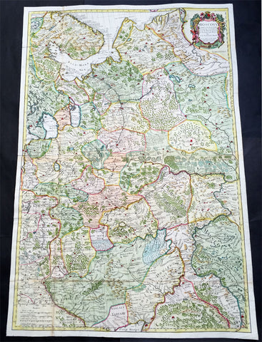
1712 Senex Very Large Antique Map of European Russia - Moscovy Corrected
Antique Map
- Title : Moscovy Corrected from ye Observations Communicated to the Royal Society of London and Paris By John Senex & John Maxwell. Sold by them at the Globe.....1712
- Ref #: 61030
- Size: 38in x 27in (990mm x 665mm)
- Date : 1712
- Condition: (A) Very Good Condition
Description:
This extraordinary, very large & beautifully hand coloured original antique map of European Russia - Moscovy - including parts of Scandinavia, the Baltic States & The Ukraine by John Senex & John Maxwell in 1712 - dated in title - and was published for Senex's large Elephant Folio General Atlas.
These large scale maps are scarce as damage and loss over time was frequent from both handling and difficulty storing safely.
General Description:
Paper thickness and quality: - Heavy and stable
Paper color: - white
Age of map color: - Original & later
Colors used: - Yellow, green, blue, red
General color appearance: - Authentic
Paper size: - 38in x 27in (990mm x 665mm)
Plate size: - 37in x 25in (930mm x 635mm)
Margins: - min. 1/2in (12mm)
Imperfections:
Margins: - None
Plate area: - Folds as issued
Verso: - Folds re-enforced on verso
Background: It is scarcely necessary to look at a map of Russia - with which we must include Siberia - to visualize the daunting task facing Russian map makers. Indeed, considering the vastness of their territory and the lack of skilled cartographers, it is surprising that relatively good maps were available for engraving and printing in most of the well known sixteenth and seventeenth century atlases. Generally, maps of that time were based on material brought back from Moscow by visitors from the West. (Ref: Tooley; M&B)
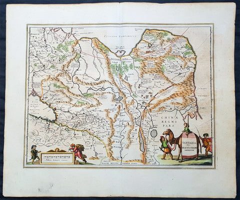
1652 Jan Jansson Antique Map of East & Central Asia, China to Russia - Tartary
Antique Map
- Title : Tartaria sive Magni Chami Imperium
- Date : 1652
- Size: 24in x 20in (610mm x 510mm)
- Ref #: 61166
- Condition: (A+) Fine Condition
Description:
This handsome beautifully hand coloured original antique map of huge region of east & central Asia from China, to Central Asia, The Caspian Sea & parts of European Russia was published by Jan Jansson in the 1652 French edition of Atlas Novus.
Background: This handsome map maps the whole of eastern Central Asia from the Caspian Sea to the Great Wall, Northern China and Manchuria.
This map is dated from a time when Tartaria vaguely meant those regions to the north of Persia, west of China & to the east of Russia. The name Siberia only began to be applied with the gradual eastward expansion of the Russian Cossacks into those areas hinted at in the accounts of Marco Polo from three centuries earlier.
The Mythical and legendary nature of the geography of this vast interior is emphasised by the inclusion of devils and dragons in the Desertum Lop to the left of the Great Wall.
The rest of the map is full of detail both real and myth, some of which is no doubt borrowed from the writings of Marco Polo considered at the time one of the foremost expert on China and Central Asia.
The newly discovered northern coastline of Nova Zembla is shown with a notation concerning the Dutch expedition led by Willem Barents in 1594-96. Interesting in Siberia, Ung quae Gog and Sumongul quae Mogog, which refers to the mythological lands of Gog and Magog. These lands, noted in the Bible as being situated in the remotest parts of the earth, were originally depicted on maps just north of Israel. The map extends west to include the Caspien Sea and Russia, but the primary focus of the map is Tartaria, Central Asia, China and Asiatic Russia. (Ref Tooley M&B)
General Description:
Paper thickness and quality: - Heavy and stable
Paper color: - off white
Age of map color: - Original
Colors used: - Green, red, orange, yellow, blue
General color appearance: - Authentic
Paper size: - 24in x 20in (610mm x 510mm)
Plate size: - 20in x 15 1/4in (510mm x 395mm)
Margins: - Min 1in (25mm)
Imperfections:
Margins: - None
Plate area: - None
Verso: - None
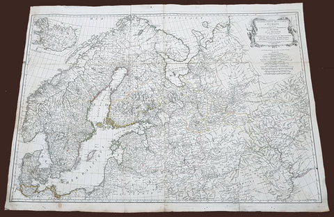
1758 D Anville Very Large Antique Map of Norway Sweden Iceland, Baltics & Russia
Antique Map
- Title : Seconde Partie de la Carte D Europe contenant Le Danemark et la Norwege, La Suede et la Russie....MDCCLVIII
- Size: 40 1/2in x 29 1/2in (1.02m x 760mm)
- Condition: (A) Very Good Condition
- Date : 1758
- Ref #: 92308
Description:
This scarce, very large (40in x 29in) highly detail map of Northern Europe Norway, Sweden, Lithuania, Baltic Countries and European Russia - was engraved in 1758 - dated in the title cartouche - by George De La Haye and was published by Jean Baptiste Bourguignon D\'Anville in his large elephant folio atlas Atlas Generale.
General Definitions:
Paper thickness and quality: - Heavy and stable
Paper color : - off white
Age of map color: - Original
Colors used: - Yellow, Green, pink
General color appearance: - Authentic
Paper size: - 40 1/2in x 29 1/2in (1.02m x 760mm)
Plate size: - 40in x 28 1/2in (1.0m x 725mm)
Margins: - Min 1/2in (12mm)
Imperfections:
Margins: - Light toning
Plate area: - Folds as issued, light separation at corners of folds
Verso: - Age toning
Background:
Before the fifteenth century the people of Southern Europe had little geographical knowledge of the Scandinavian World except from sketchy detail shown in the Catalan Atlas (1375) and on a number of portolani embracing Denmark and the southern tip of Norway. It was not until 1427 that a manuscript map prepared about that time by Claudius Clavus (b.1388) a Dane who spent some time in Rome, made available to scholars a tolerable outline of the northern countries and Greenland. That was to remain the best map available for the rest of the century and it was used as the basis for maps of Scandinavia in early printed editions of Ptolemy. Others by Nicolaus Cusanus (1491) and Ehrhard Etzlaub (c. 1492) followed but, needless to say, these are extremely rare; even the later maps by Olaus Magnus and Marcus Jordan, where they have survived at all , are known only by a very few examples. In fact, apart from the rare appearance of an early Ptolemy map, the oldest of Scandinavia which a collector is likely to find are those of Munster\'s Cosmograhy first published in 1544. In the following centuries the few maps and charts complied in Scandinavia were usually published in Amsterdam, Antwerp, Paris or Nuremberg, the most important maps often being incorporated in the major Dutch, French & German Atlases. (Ref: Tooley; M&B)


