
Recent Acquisitions (16)
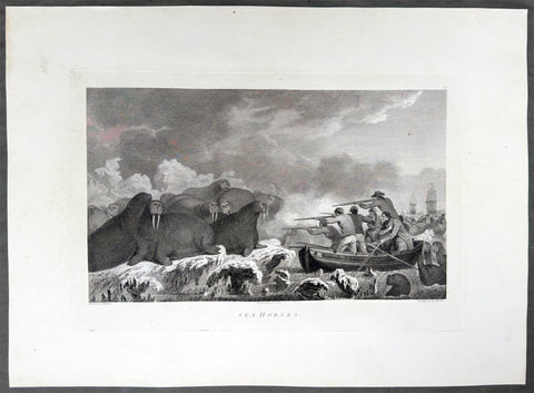
1784 James Cook & John Webber Antique 1st Edition Print Hunting Walrus Arctic Circle, 1778
Antique Print
- Title : Sea Horses
- Ref : 61270
- Size: 21 3/4in x 15 1/2in (550mm x 395mm)
- Date : 1784
- Condition: (A+) Fine Condition
Description:
This scarce first-edition large antique print, plate #52, the only plate engraved of The Arctic region, north of the Bering Straits, in August 1778, of Walruses, commonly called at the time Sea Horses, was drawn by John Webber (Cooks official onboard artist) and expertly engraved by Edmund Scott for the official, British Admiralty-sanctioned account of Cooks journey: "A Voyage to the Pacific Ocean... In Three Volumes. Vol. I & II and Atlas, written by James Cook & Capt J Clerk, F.R.S. Vol. III in London, 1784.
Cook's "Sea Horses" were walruses, which his crews met on the pack ice in the Arctic, north of the Bering Strait, in August 1778. The ships were short of fresh food, and on 19 August, a little south of Icy Cape at about 70° to 71°N, a huge number of walruses were seen lying on the ice. Cook sent two boats to hunt them, and by seven that evening seven had been brought aboard the Resolution. Further hunts took place on 27 and 28 August, and the ships shot more walrus in July 1779, during their second stay in the ice. The crews were divided about the taste of the meat, and Cook found the animals less dangerous than authors had claimed, more fearsome in appearance than in reality. He also complained that he had never seen a good drawing of one, and could not see why they were called sea horses, since they looked like a much larger seal. Webber took care to draw the walrus from several angles, and made several versions of the scene, which became plate 52 in the atlas. A large painting of it was shown at the Royal Academy in 1784.
Exceptional and highly sought-after large museum quality prints, perfect for collectors of Captain Cook history, maritime art, and early Australian, Pacific & Polar exploration.
General Definitions:
Paper thickness and quality: - Heavy and stable
Paper color : - off white
Age of map color: -
Colors used: -
General color appearance: -
Paper size: - 21 3/4in x 15 3/4in (550mm x 395mm)
Plate size: - 15 3/46in x 10in (400mm x 255mm)
Margins: - Min 2in (50mm)
Imperfections:
Margins: - None
Plate area: - None
Verso: - None
Background:
Captain James Cook's third and final voyage (1776–1780) set out from Plymouth to search for a Northwest Passage between the Pacific and Atlantic, sailing via the Cape of Good Hope and the Kerguelen Islands before visiting Tasmania and New Zealand and threading through the Pacific islands — Tonga, Tahiti, and the Society Islands — over the course of 1777. In January 1778 Cook became the first European to reach the Hawaiian Islands, which he named the Sandwich Islands, and from there sailed to the west coast of North America, charting the coastline from Oregon up through Nootka Sound, Unalaska (Alaska), and the Bering Strait into the Arctic Ocean, where pack ice forced him to turn back in August 1778. He wintered in Hawaii, anchoring at Kealakekua Bay in January 1779, where a dispute with islanders turned violent and Cook was killed on 14 February 1779. Command passed to Charles Clerke, who made one more unsuccessful attempt at the Northwest Passage before the expedition sailed home via Kamchatka Peninsula (Russia) , Macau, and the Cape of Good Hope, finally reaching England in October 1780.
Captain James Cook's third and final voyage A Voyage to the Pacific Ocean... In Three Volumes. Vol. I & II and Atlas, was illustrated in the original 1784/5 atlas containing 2 maps and 61 prints, engraved after John Webber's drawings (Cooks official artist on the voyage) by various engravers. Below is each location visited by Cook and later Capt. Clerk with the dates and corresponding prints.
Kerguelen Islands (Christmas Harbour) — 25 December 1776
• Plate 4 — A View of Christmas Harbour, in Kerguelen's Land
Van Diemen's Land (Tasmania), Adventure Bay — January 1777
• Plate 6 — A man of Van Diemen's Land
• Plate 7 — A woman of Van Diemen's Land
• Plate 8 — An opossum of Van Diemen's Land
Queen Charlotte Sound, New Zealand — February 1777
• Plate 10 — The Inside of a Hippah in New Zeeland
Mangaia, Cook Islands — March–April 1777
• Plate 11 — A man of Mangea
Tongan (Friendly) Islands — April–July 1777
• Plate 13 — A view at Anamooka
• Plate 14 — The reception of Captain Cook, in Hapaee
• Plate 15 — A boxing match, in Hapaee
• Plate 16 — A night dance by men, in Hapaee
• Plate 17 — A night dance by women, in Hapaee
• Plate 18 — Poulaho, King of the Friendly Islands
• Plate 20 — Poulaho, King of the Friendly Islands, drinking kava
• Plate 21 — A Fiatooka (Morai), in Tongataboo
• Plate 22 — The Natche, a ceremony in Tongataboo
• Plate 23 — A woman of Eaoo
Tahiti (Otaheite) — August 1777
• Plate 25 — A human sacrifice, in a marai
• Plate 26 — The body of Tee, a chief, as preserved after death
• Plate 27 — A young woman of Otaheite, bringing a present
• Plate 28 — A dance in Otaheite
• Plate 29 — A young woman of Otaheite, dancing
Huahine, Society Islands — October–November 1777
• Plate 31 — A view of Huaheine
Christmas Island (Kiritimati) — December 1777
• Discovered on this leg of the voyage; not separately plated
Kauai (Atooi), Hawaiian Islands — January 1778 (first European landfall in Hawaii) • Plate 33 — A Morai, in Atooi
• Plate34 — The inside of the house, in the Morai
• Plate 35 — An inland view, in Atooi
Nootka Sound, Vancouver Island — March–April 1778
• Plate 38 — A man of Nootka Sound
• Plate 39 — A woman of Nootka Sound
• Plate 40 — Various articles, at Nootka Sound
• Plate 41 — A view of the habitation in Nootka Sound
• Plate 42 — The inside of a house in Nootka Sound
• Plate 43 — A sea otter
Prince William Sound, Alaska — May 1778
• Plate 45 — A view of Snug Corner, in Prince William Sound
• Plate 46 — A man of Prince William Sound
• Plate 47 — A woman of Prince William Sound
Unalaska (Oonalashka) — June and October 1778
• Plate 48 — A man of Oonalashka
• Plate 49 — A woman of Oonalashka
• Plate 50 — Canoes of Oonalashka
• Plate 56 — Caps of the natives of Oonalashka
• Plate 57 — Natives of Oonalashka, and their habitations
• Plate 58 — The inside of a house, in Oonalashka
Norton Sound and the Chukchi Coast, Siberia — August 1778
• Plate 51 — The Tschuktschi, and their habitations
• Plate 54 — Inhabitants of Norton Sound and their habitations
Arctic Ocean, near the Bering Strait — August 1778 (Cook turned back by ice)
• Plate 52 — Sea horses (walruses)
Kealakekua Bay, Hawaii (Owyhee) — January–February 1779 (Cook killed 14 February 1779)
• Plate 60 — An offering before Captain Cook, in the Sandwich Islands
• Plate 61 — Tereoboo, King of Owyhee, bringing presents to Captain Cook
• Plate 62 — A man of the Sandwich Islands, dancing
• Plate 63 — A young woman of the Sandwich Islands
• Plate 64 — A man of the Sandwich Islands, with his helmet
• Plate 65 — A canoe of the Sandwich Islands, the rowers masked
• Plate 66 — A man of the Sandwich Islands, in a mask
• Plate 67 — Various articles, at the Sandwich Islands
• Plate 68 — A view of Karakakooa, in Owyhee
Kamchatka, St Peter and St Paul Harbour (Petropavlovsk) — spring and summer 1779
• Plate 70 — A man of Kamtschatka, travelling in winter
• Plate 71 — A sledge of Kamtschatka
• Plate 72 — A view at Bolcheretzkoi, in Kamtschatka
• Plate 73 — A white bear
• Plate 74 — A view of the town and harbour of St Peter and St Paul
• Plate 75 — A man of Kamtschatka
• Plate 76 — A woman of Kamtschatka
• Plate 77 — Summer and winter habitations, in Kamtschatka
• Plate 78 — The inside of a winter habitation in Kamtschatka
Return to England — October 1780
John Webber (1751–1793) was a Swiss-born British artist who served as the official expedition artist on Cook's third voyage, tasked with visually documenting the peoples, landscapes, and events the ships encountered. His drawings — later engraved as the 61 plates in the atlas accompanying the 1784 official account — provided some of the first detailed European depictions of Hawaii, the Pacific Northwest coast, and other Pacific and Arctic locales, including the scene of Cook's death at Kealakekua Bay. Webber was elected a full Royal Academician in 1791 and continued to exhibit landscape work until his death in 1793.
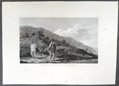
1784 James Cook & John Webber Antique 1st Edition Print Village of Norton Sound, Alaska 1778
Antique Print
- Title : Inhabitants of Norton Sound and their Habitations
- Ref : 61271
- Size: 21 3/4in x 15 3/4in (550mm x 395mm)
- Date : 1784
- Condition: (A) Very Good Condition
Description:
This scarce first-edition large antique print, plate #54, the only plate of Norton Sound in the Bering Straits, Alaska a view of a village & its inhabitants in September 1778, was drawn by John Webber (Cooks official onboard artist) and expertly engraved by Benjamin Thomas Pouncy for the official, British Admiralty-sanctioned account of Cooks journey: "A Voyage to the Pacific Ocean... In Three Volumes. Vol. I & II and Atlas, written by James Cook & Capt J Clerk, F.R.S. Vol. III in London, 1784.
In the summer of 1778, Cook's search for the Northwest Passage took him to both sides of the Bering Strait. He landed on the Chukotski Peninsula in Siberia on 10 August and met the Chukchi, who welcomed his party, and the two sides traded European knives, beads and tobacco for Chukchi clothes, gloves and arrows. Though the visit lasted only a few hours, Webber sketched their clothing, dogs and dome-shaped summer huts, and these became the plate "The Tschuktschi, and their Habitations".
The ships then passed north through the strait on 11 August. Pack ice stopped them off Alaska on 18 August, at about 70°N, and Cook spent the next eleven days working westward along the ice edge before reaching the Siberian coast again on 29 August. He gave up the search then and sailed south through the strait on 2 September. Turning to the Alaskan side, he explored the inlet he named Norton Sound after Sir Fletcher Norton, Speaker of the House of Commons, naming Cape Denbigh on 11 September and Besborough Island on 12 September. Like the Siberian coast, it offered no way through, since Norton Sound proved a shallow gulf and not a passage. Webber's plate of a family with their shelter and kayak is the main record of the people there. Cook then sailed for Unalaska and, after repairs, south to Hawaii for the winter.
Exceptional and highly sought-after large museum quality prints, perfect for collectors of Captain Cook history, maritime art, and early Australian, Pacific & Polar exploration.
General Definitions:
Paper thickness and quality: - Heavy and stable
Paper color : - off white
Age of map color: -
Colors used: -
General color appearance: -
Paper size: - 21 3/4in x 15 3/4in (550mm x 395mm)
Plate size: - 15 3/46in x 10in (400mm x 255mm)
Margins: - Min 2in (50mm)
Imperfections:
Margins: - Light creasing
Plate area: - Light creasing
Verso: - Light creasing
Background:
Captain James Cook's third and final voyage (1776–1780) set out from Plymouth to search for a Northwest Passage between the Pacific and Atlantic, sailing via the Cape of Good Hope and the Kerguelen Islands before visiting Tasmania and New Zealand and threading through the Pacific islands — Tonga, Tahiti, and the Society Islands — over the course of 1777. In January 1778 Cook became the first European to reach the Hawaiian Islands, which he named the Sandwich Islands, and from there sailed to the west coast of North America, charting the coastline from Oregon up through Nootka Sound, Unalaska (Alaska), and the Bering Strait into the Arctic Ocean, where pack ice forced him to turn back in August 1778. He wintered in Hawaii, anchoring at Kealakekua Bay in January 1779, where a dispute with islanders turned violent and Cook was killed on 14 February 1779. Command passed to Charles Clerke, who made one more unsuccessful attempt at the Northwest Passage before the expedition sailed home via Kamchatka Peninsula (Russia) , Macau, and the Cape of Good Hope, finally reaching England in October 1780.
Captain James Cook's third and final voyage A Voyage to the Pacific Ocean... In Three Volumes. Vol. I & II and Atlas, was illustrated in the original 1784/5 atlas containing 2 maps and 61 prints, engraved after John Webber's drawings (Cooks official artist on the voyage) by various engravers. Below is each location visited by Cook and later Capt. Clerk with the dates and corresponding prints.
Kerguelen Islands (Christmas Harbour) — 25 December 1776
• Plate 4 — A View of Christmas Harbour, in Kerguelen's Land
Van Diemen's Land (Tasmania), Adventure Bay — January 1777
• Plate 6 — A man of Van Diemen's Land
• Plate 7 — A woman of Van Diemen's Land
• Plate 8 — An opossum of Van Diemen's Land
Queen Charlotte Sound, New Zealand — February 1777
• Plate 10 — The Inside of a Hippah in New Zeeland
Mangaia, Cook Islands — March–April 1777
• Plate 11 — A man of Mangea
Tongan (Friendly) Islands — April–July 1777
• Plate 13 — A view at Anamooka
• Plate 14 — The reception of Captain Cook, in Hapaee
• Plate 15 — A boxing match, in Hapaee
• Plate 16 — A night dance by men, in Hapaee
• Plate 17 — A night dance by women, in Hapaee
• Plate 18 — Poulaho, King of the Friendly Islands
• Plate 20 — Poulaho, King of the Friendly Islands, drinking kava
• Plate 21 — A Fiatooka (Morai), in Tongataboo
• Plate 22 — The Natche, a ceremony in Tongataboo
• Plate 23 — A woman of Eaoo
Tahiti (Otaheite) — August 1777
• Plate 25 — A human sacrifice, in a marai
• Plate 26 — The body of Tee, a chief, as preserved after death
• Plate 27 — A young woman of Otaheite, bringing a present
• Plate 28 — A dance in Otaheite
• Plate 29 — A young woman of Otaheite, dancing
Huahine, Society Islands — October–November 1777
• Plate 31 — A view of Huaheine
Christmas Island (Kiritimati) — December 1777
• Discovered on this leg of the voyage; not separately plated
Kauai (Atooi), Hawaiian Islands — January 1778 (first European landfall in Hawaii) • Plate 33 — A Morai, in Atooi
• Plate34 — The inside of the house, in the Morai
• Plate 35 — An inland view, in Atooi
Nootka Sound, Vancouver Island — March–April 1778
• Plate 38 — A man of Nootka Sound
• Plate 39 — A woman of Nootka Sound
• Plate 40 — Various articles, at Nootka Sound
• Plate 41 — A view of the habitation in Nootka Sound
• Plate 42 — The inside of a house in Nootka Sound
• Plate 43 — A sea otter
Prince William Sound, Alaska — May 1778
• Plate 45 — A view of Snug Corner, in Prince William Sound
• Plate 46 — A man of Prince William Sound
• Plate 47 — A woman of Prince William Sound
Unalaska (Oonalashka) — June and October 1778
• Plate 48 — A man of Oonalashka
• Plate 49 — A woman of Oonalashka
• Plate 50 — Canoes of Oonalashka
• Plate 56 — Caps of the natives of Oonalashka
• Plate 57 — Natives of Oonalashka, and their habitations
• Plate 58 — The inside of a house, in Oonalashka
Norton Sound and the Chukchi Coast, Siberia — August 1778
• Plate 51 — The Tschuktschi, and their habitations
• Plate 54 — Inhabitants of Norton Sound and their habitations
Arctic Ocean, near the Bering Strait — August 1778 (Cook turned back by ice)
• Plate 52 — Sea horses (walruses)
Kealakekua Bay, Hawaii (Owyhee) — January–February 1779 (Cook killed 14 February 1779)
• Plate 60 — An offering before Captain Cook, in the Sandwich Islands
• Plate 61 — Tereoboo, King of Owyhee, bringing presents to Captain Cook
• Plate 62 — A man of the Sandwich Islands, dancing
• Plate 63 — A young woman of the Sandwich Islands
• Plate 64 — A man of the Sandwich Islands, with his helmet
• Plate 65 — A canoe of the Sandwich Islands, the rowers masked
• Plate 66 — A man of the Sandwich Islands, in a mask
• Plate 67 — Various articles, at the Sandwich Islands
• Plate 68 — A view of Karakakooa, in Owyhee
Kamchatka, St Peter and St Paul Harbour (Petropavlovsk) — spring and summer 1779
• Plate 70 — A man of Kamtschatka, travelling in winter
• Plate 71 — A sledge of Kamtschatka
• Plate 72 — A view at Bolcheretzkoi, in Kamtschatka
• Plate 73 — A white bear
• Plate 74 — A view of the town and harbour of St Peter and St Paul
• Plate 75 — A man of Kamtschatka
• Plate 76 — A woman of Kamtschatka
• Plate 77 — Summer and winter habitations, in Kamtschatka
• Plate 78 — The inside of a winter habitation in Kamtschatka
Return to England — October 1780
John Webber (1751–1793) was a Swiss-born British artist who served as the official expedition artist on Cook's third voyage, tasked with visually documenting the peoples, landscapes, and events the ships encountered. His drawings — later engraved as the 61 plates in the atlas accompanying the 1784 official account — provided some of the first detailed European depictions of Hawaii, the Pacific Northwest coast, and other Pacific and Arctic locales, including the scene of Cook's death at Kealakekua Bay. Webber was elected a full Royal Academician in 1791 and continued to exhibit landscape work until his death in 1793.
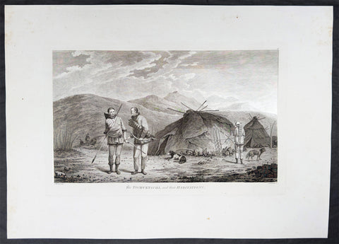
1784 James Cook & John Webber Antique 1st Edition Print Village in Chukotski Peninsula, Siberia , 1778
Antique Print
- Title : The Tschuktschi, and their Habitations
- Ref : 61228
- Size: 21 3/4in x 15 1/2in (550mm x 395mm)
- Date : 1784
- Condition: (A) Very Good Condition
Description:
This scarce first-edition large antique print, plate #51, the only plate illustrating the Chukotski Peninsula in Siberia, of a view of a Chukotski Village & its inhabitants in August 1778, was drawn by John Webber (Cooks official onboard artist) and expertly engraved by Daniel Lerpiniere for the official, British Admiralty-sanctioned account of Cooks journey: "A Voyage to the Pacific Ocean... In Three Volumes. Vol. I & II and Atlas, written by James Cook & Capt J Clerk, F.R.S. Vol. III in London, 1784.
In the summer of 1778, Cook's search for the Northwest Passage took him to both sides of the Bering Strait. He landed on the Chukotski Peninsula in Siberia on 10 August and met the Chukchi, who welcomed his party, and the two sides traded European knives, beads and tobacco for Chukchi clothes, gloves and arrows. Though the visit lasted only a few hours, Webber sketched their clothing, dogs and dome-shaped summer huts, and these became the plate "The Tschuktschi, and their Habitations".
The ships then passed north through the strait on 11 August. Pack ice stopped them off Alaska on 18 August, at about 70°N, and Cook spent the next eleven days working westward along the ice edge before reaching the Siberian coast again on 29 August. He gave up the search then and sailed south through the strait on 2 September. Turning to the Alaskan side, he explored the inlet he named Norton Sound after Sir Fletcher Norton, Speaker of the House of Commons, naming Cape Denbigh on 11 September and Besborough Island on 12 September. Like the Siberian coast, it offered no way through, since Norton Sound proved a shallow gulf and not a passage. Webber's plate of a family with their shelter and kayak is the main record of the people there. Cook then sailed for Unalaska and, after repairs, south to Hawaii for the winter.
Exceptional and highly sought-after large museum quality prints, perfect for collectors of Captain Cook history, maritime art, and early Australian, Pacific & Polar exploration.
General Definitions:
Paper thickness and quality: - Heavy and stable
Paper color : - off white
Age of map color: -
Colors used: -
General color appearance: -
Paper size: - 21 3/4in x 15 1/2in (550mm x 395mm)
Plate size: - 16in x 10in (405mm x 255mm)
Margins: - Min 2in (50mm)
Imperfections:
Margins: - Light creasing
Plate area: - Light creasing
Verso: - Light creasing
Background:
Captain James Cook's third and final voyage (1776–1780) set out from Plymouth to search for a Northwest Passage between the Pacific and Atlantic, sailing via the Cape of Good Hope and the Kerguelen Islands before visiting Tasmania and New Zealand and threading through the Pacific islands — Tonga, Tahiti, and the Society Islands — over the course of 1777. In January 1778 Cook became the first European to reach the Hawaiian Islands, which he named the Sandwich Islands, and from there sailed to the west coast of North America, charting the coastline from Oregon up through Nootka Sound, Unalaska (Alaska), and the Bering Strait into the Arctic Ocean, where pack ice forced him to turn back in August 1778. He wintered in Hawaii, anchoring at Kealakekua Bay in January 1779, where a dispute with islanders turned violent and Cook was killed on 14 February 1779. Command passed to Charles Clerke, who made one more unsuccessful attempt at the Northwest Passage before the expedition sailed home via Kamchatka Peninsula (Russia) , Macau, and the Cape of Good Hope, finally reaching England in October 1780.
Captain James Cook's third and final voyage A Voyage to the Pacific Ocean... In Three Volumes. Vol. I & II and Atlas, was illustrated in the original 1784/5 atlas containing 2 maps and 61 prints, engraved after John Webber's drawings (Cooks official artist on the voyage) by various engravers. Below is each location visited by Cook and later Capt. Clerk with the dates and corresponding prints.
Kerguelen Islands (Christmas Harbour) — 25 December 1776
• Plate 4 — A View of Christmas Harbour, in Kerguelen's Land
Van Diemen's Land (Tasmania), Adventure Bay — January 1777
• Plate 6 — A man of Van Diemen's Land
• Plate 7 — A woman of Van Diemen's Land
• Plate 8 — An opossum of Van Diemen's Land
Queen Charlotte Sound, New Zealand — February 1777
• Plate 10 — The Inside of a Hippah in New Zeeland
Mangaia, Cook Islands — March–April 1777
• Plate 11 — A man of Mangea
Tongan (Friendly) Islands — April–July 1777
• Plate 13 — A view at Anamooka
• Plate 14 — The reception of Captain Cook, in Hapaee
• Plate 15 — A boxing match, in Hapaee
• Plate 16 — A night dance by men, in Hapaee
• Plate 17 — A night dance by women, in Hapaee
• Plate 18 — Poulaho, King of the Friendly Islands
• Plate 20 — Poulaho, King of the Friendly Islands, drinking kava
• Plate 21 — A Fiatooka (Morai), in Tongataboo
• Plate 22 — The Natche, a ceremony in Tongataboo
• Plate 23 — A woman of Eaoo
Tahiti (Otaheite) — August 1777
• Plate 25 — A human sacrifice, in a marai
• Plate 26 — The body of Tee, a chief, as preserved after death
• Plate 27 — A young woman of Otaheite, bringing a present
• Plate 28 — A dance in Otaheite
• Plate 29 — A young woman of Otaheite, dancing
Huahine, Society Islands — October–November 1777
• Plate 31 — A view of Huaheine
Christmas Island (Kiritimati) — December 1777
• Discovered on this leg of the voyage; not separately plated
Kauai (Atooi), Hawaiian Islands — January 1778 (first European landfall in Hawaii) • Plate 33 — A Morai, in Atooi
• Plate34 — The inside of the house, in the Morai
• Plate 35 — An inland view, in Atooi
Nootka Sound, Vancouver Island — March–April 1778
• Plate 38 — A man of Nootka Sound
• Plate 39 — A woman of Nootka Sound
• Plate 40 — Various articles, at Nootka Sound
• Plate 41 — A view of the habitation in Nootka Sound
• Plate 42 — The inside of a house in Nootka Sound
• Plate 43 — A sea otter
Prince William Sound, Alaska — May 1778
• Plate 45 — A view of Snug Corner, in Prince William Sound
• Plate 46 — A man of Prince William Sound
• Plate 47 — A woman of Prince William Sound
Unalaska (Oonalashka) — June and October 1778
• Plate 48 — A man of Oonalashka
• Plate 49 — A woman of Oonalashka
• Plate 50 — Canoes of Oonalashka
• Plate 56 — Caps of the natives of Oonalashka
• Plate 57 — Natives of Oonalashka, and their habitations
• Plate 58 — The inside of a house, in Oonalashka
Norton Sound and the Chukchi Coast, Siberia — August 1778
• Plate 51 — The Tschuktschi, and their habitations
• Plate 54 — Inhabitants of Norton Sound and their habitations
Arctic Ocean, near the Bering Strait — August 1778 (Cook turned back by ice)
• Plate 52 — Sea horses (walruses)
Kealakekua Bay, Hawaii (Owyhee) — January–February 1779 (Cook killed 14 February 1779)
• Plate 60 — An offering before Captain Cook, in the Sandwich Islands
• Plate 61 — Tereoboo, King of Owyhee, bringing presents to Captain Cook
• Plate 62 — A man of the Sandwich Islands, dancing
• Plate 63 — A young woman of the Sandwich Islands
• Plate 64 — A man of the Sandwich Islands, with his helmet
• Plate 65 — A canoe of the Sandwich Islands, the rowers masked
• Plate 66 — A man of the Sandwich Islands, in a mask
• Plate 67 — Various articles, at the Sandwich Islands
• Plate 68 — A view of Karakakooa, in Owyhee
Kamchatka, St Peter and St Paul Harbour (Petropavlovsk) — spring and summer 1779
• Plate 70 — A man of Kamtschatka, travelling in winter
• Plate 71 — A sledge of Kamtschatka
• Plate 72 — A view at Bolcheretzkoi, in Kamtschatka
• Plate 73 — A white bear
• Plate 74 — A view of the town and harbour of St Peter and St Paul
• Plate 75 — A man of Kamtschatka
• Plate 76 — A woman of Kamtschatka
• Plate 77 — Summer and winter habitations, in Kamtschatka
• Plate 78 — The inside of a winter habitation in Kamtschatka
Return to England — October 1780
John Webber (1751–1793) was a Swiss-born British artist who served as the official expedition artist on Cook's third voyage, tasked with visually documenting the peoples, landscapes, and events the ships encountered. His drawings — later engraved as the 61 plates in the atlas accompanying the 1784 official account — provided some of the first detailed European depictions of Hawaii, the Pacific Northwest coast, and other Pacific and Arctic locales, including the scene of Cook's death at Kealakekua Bay. Webber was elected a full Royal Academician in 1791 and continued to exhibit landscape work until his death in 1793.
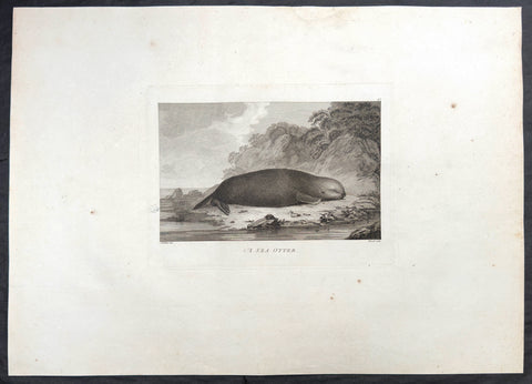
1784 James Cook & John Webber Antique 1st Edition Print Sea Otter, Nootka Sound Vancouver Is. Canada, 1778
Antique Print
- Title : A Sea Otter
- Ref : 61224
- Size: 20 3/4in x 15 1/2in (525mm x 395mm)
- Date : 1784
- Condition: (A) Very Good Condition
Description:
This scarce first-edition large antique print, plate #43, the sixth plate engraved of Nootka Sound and its inhabitants, of a Sea Otter in Nootka Sound Vancouver Island Canada in April 1778, whose fur was much prized by Cook and crew for clothes and later trade during their voyage looking for the NW passage, was drawn by John Webber (Cooks official onboard artist) and expertly engraved by Paul Mazell for the official, British Admiralty-sanctioned account of Cooks journey: "A Voyage to the Pacific Ocean... In Three Volumes. Vol. I & II and Atlas, written by James Cook & Capt J Clerk, F.R.S. Vol. III in London, 1784.
Cook's ships Resolution and Discovery reached the American Northwest Coast in late March 1778 and anchored in Ship Cove, in the sound Cook named King George's Sound. It later became known as Nootka Sound, a name that came from a misunderstanding of what the local people said. The ships stayed from 29 March to 26 April, mainly to repair rigging and replace masts and spars, and this was the first sustained contact between Europeans and the Nuu-chah-nulth people of the region. The Nuu-chah-nulth came out in canoes to trade, and Cook's crews bought many sea otter pelts and other furs in exchange for iron, brass and other metal goods. The men used the skins as warm bedding and clothing. The expedition's artist, John Webber, drew the people, their houses and carvings, and the animals of the coast, including the sea otter. He and Cook visited the village of Yuquot on 22 April. Cook did not yet understand how valuable the pelts were. After his death in Hawaii in 1779, the expedition reached Canton in China, where the furs sold for very high prices, and some of the crew wanted to go straight back for more. The published account of the voyage in 1784 spread the news, and Nootka Sound became the starting point of the maritime fur trade.
Exceptional and highly sought-after large museum quality prints, perfect for collectors of Captain Cook history, maritime art, and early Australian, Pacific & Polar exploration.
General Definitions:
Paper thickness and quality: - Heavy and stable
Paper color : - off white
Age of map color: -
Colors used: -
General color appearance: -
Paper size: - 20 3/4in x 15 1/2in (525mm x 395mm)
Plate size: - 10 1/2in x 7 3/4in (265mm x 195mm)
Margins: - Min 2in (50mm)
Imperfections:
Margins: - Light creasing
Plate area: - Light creasing
Verso: - Light creasing
Background:
Captain James Cook's third and final voyage (1776–1780) set out from Plymouth to search for a Northwest Passage between the Pacific and Atlantic, sailing via the Cape of Good Hope and the Kerguelen Islands before visiting Tasmania and New Zealand and threading through the Pacific islands — Tonga, Tahiti, and the Society Islands — over the course of 1777. In January 1778 Cook became the first European to reach the Hawaiian Islands, which he named the Sandwich Islands, and from there sailed to the west coast of North America, charting the coastline from Oregon up through Nootka Sound, Unalaska (Alaska), and the Bering Strait into the Arctic Ocean, where pack ice forced him to turn back in August 1778. He wintered in Hawaii, anchoring at Kealakekua Bay in January 1779, where a dispute with islanders turned violent and Cook was killed on 14 February 1779. Command passed to Charles Clerke, who made one more unsuccessful attempt at the Northwest Passage before the expedition sailed home via Kamchatka Peninsula (Russia) , Macau, and the Cape of Good Hope, finally reaching England in October 1780.
Captain James Cook's third and final voyage A Voyage to the Pacific Ocean... In Three Volumes. Vol. I & II and Atlas, was illustrated in the original 1784/5 atlas containing 2 maps and 61 prints, engraved after John Webber's drawings (Cooks official artist on the voyage) by various engravers. Below is each location visited by Cook and later Capt. Clerk with the dates and corresponding prints.
Kerguelen Islands (Christmas Harbour) — 25 December 1776
• Plate 4 — A View of Christmas Harbour, in Kerguelen's Land
Van Diemen's Land (Tasmania), Adventure Bay — January 1777
• Plate 6 — A man of Van Diemen's Land
• Plate 7 — A woman of Van Diemen's Land
• Plate 8 — An opossum of Van Diemen's Land
Queen Charlotte Sound, New Zealand — February 1777
• Plate 10 — The Inside of a Hippah in New Zeeland
Mangaia, Cook Islands — March–April 1777
• Plate 11 — A man of Mangea
Tongan (Friendly) Islands — April–July 1777
• Plate 13 — A view at Anamooka
• Plate 14 — The reception of Captain Cook, in Hapaee
• Plate 15 — A boxing match, in Hapaee
• Plate 16 — A night dance by men, in Hapaee
• Plate 17 — A night dance by women, in Hapaee
• Plate 18 — Poulaho, King of the Friendly Islands
• Plate 20 — Poulaho, King of the Friendly Islands, drinking kava
• Plate 21 — A Fiatooka (Morai), in Tongataboo
• Plate 22 — The Natche, a ceremony in Tongataboo
• Plate 23 — A woman of Eaoo
Tahiti (Otaheite) — August 1777
• Plate 25 — A human sacrifice, in a marai
• Plate 26 — The body of Tee, a chief, as preserved after death
• Plate 27 — A young woman of Otaheite, bringing a present
• Plate 28 — A dance in Otaheite
• Plate 29 — A young woman of Otaheite, dancing
Huahine, Society Islands — October–November 1777
• Plate 31 — A view of Huaheine
Christmas Island (Kiritimati) — December 1777
• Discovered on this leg of the voyage; not separately plated
Kauai (Atooi), Hawaiian Islands — January 1778 (first European landfall in Hawaii) • Plate 33 — A Morai, in Atooi
• Plate34 — The inside of the house, in the Morai
• Plate 35 — An inland view, in Atooi
Nootka Sound, Vancouver Island — March–April 1778
• Plate 38 — A man of Nootka Sound
• Plate 39 — A woman of Nootka Sound
• Plate 40 — Various articles, at Nootka Sound
• Plate 41 — A view of the habitation in Nootka Sound
• Plate 42 — The inside of a house in Nootka Sound
• Plate 43 — A sea otter
Prince William Sound, Alaska — May 1778
• Plate 45 — A view of Snug Corner, in Prince William Sound
• Plate 46 — A man of Prince William Sound
• Plate 47 — A woman of Prince William Sound
Unalaska (Oonalashka) — June and October 1778
• Plate 48 — A man of Oonalashka
• Plate 49 — A woman of Oonalashka
• Plate 50 — Canoes of Oonalashka
• Plate 56 — Caps of the natives of Oonalashka
• Plate 57 — Natives of Oonalashka, and their habitations
• Plate 58 — The inside of a house, in Oonalashka
Norton Sound and the Chukchi Coast, Siberia — August 1778
• Plate 51 — The Tschuktschi, and their habitations
• Plate 54 — Inhabitants of Norton Sound and their habitations
Arctic Ocean, near the Bering Strait — August 1778 (Cook turned back by ice)
• Plate 52 — Sea horses (walruses)
Kealakekua Bay, Hawaii (Owyhee) — January–February 1779 (Cook killed 14 February 1779)
• Plate 60 — An offering before Captain Cook, in the Sandwich Islands
• Plate 61 — Tereoboo, King of Owyhee, bringing presents to Captain Cook
• Plate 62 — A man of the Sandwich Islands, dancing
• Plate 63 — A young woman of the Sandwich Islands
• Plate 64 — A man of the Sandwich Islands, with his helmet
• Plate 65 — A canoe of the Sandwich Islands, the rowers masked
• Plate 66 — A man of the Sandwich Islands, in a mask
• Plate 67 — Various articles, at the Sandwich Islands
• Plate 68 — A view of Karakakooa, in Owyhee
Kamchatka, St Peter and St Paul Harbour (Petropavlovsk) — spring and summer 1779
• Plate 70 — A man of Kamtschatka, travelling in winter
• Plate 71 — A sledge of Kamtschatka
• Plate 72 — A view at Bolcheretzkoi, in Kamtschatka
• Plate 73 — A white bear
• Plate 74 — A view of the town and harbour of St Peter and St Paul
• Plate 75 — A man of Kamtschatka
• Plate 76 — A woman of Kamtschatka
• Plate 77 — Summer and winter habitations, in Kamtschatka
• Plate 78 — The inside of a winter habitation in Kamtschatka
Return to England — October 1780
John Webber (1751–1793) was a Swiss-born British artist who served as the official expedition artist on Cook's third voyage, tasked with visually documenting the peoples, landscapes, and events the ships encountered. His drawings — later engraved as the 61 plates in the atlas accompanying the 1784 official account — provided some of the first detailed European depictions of Hawaii, the Pacific Northwest coast, and other Pacific and Arctic locales, including the scene of Cook's death at Kealakekua Bay. Webber was elected a full Royal Academician in 1791 and continued to exhibit landscape work until his death in 1793.
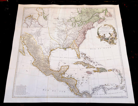
1746 D Anville Large Antique Map of North America - Pre French Indian & Rev. War
Antique Map
-
Title : Amerique Septentrionale Publiee sous les Auspices de Monseigneur le Duc d Orleans.. Par Le Snr. D Anville MDCCXLVI
- Ref #: 17010
-
Condition: (A+) Fine Condition
- Size: 42 1/2in x 37in (1.08m x 940mm)
- Date : 1746
Description:
This large important original copper plate engraved hand coloured antique map of North America, in 12 sheets joined, was engraved in 1746 - dated in the cartouche - and was published by Jean-Baptiste Bourguinon D Anville in his Elephant Folio Atlas Generale.
This map was instrumental in instructing the European Colonial powers of the time, England France & Spain the importance of dominating the New World, that ultimately led to the French and Indian War of 1754–63. This conflict determined the political direction of North America leading to the American War of Independence in 1775 and ultimately the formation of The United States of America.
To illustrate the importance of cartography in the mid eighteenth century, especially that of North America, a J B D Anville map is essential. D Anville dominated 18th century European cartography with many of his cartographical achievements, especially in North America, copied by many of his contemporaries such as Kitchen, Sayer, Homann, Seutter, Mitchell and others .
He was one of the first to leave blank spaces in his maps, where knowledge was scant or insufficient. His representation of the great lakes is superior to that of his contemporary John Mitchell, responsible for publishing one of the most famous mid 18th century maps of North America, A Map of the British and French Dominions in North America on 8 sheets in 1755 and remained the standard map of North America up until the end of the 18th century. (Ref: Tooley, Printed maps of America, 104; The Mapping of America 316)
General Definitions:
Paper thickness and quality: - Heavy and stable
Paper color : - off white
Age of map color: - Original & later
Colors used: - Red, yellow, green, blue
General color appearance: - Authentic
Paper size: - 42 1/2in x 37in (1.08m x 940mm)
Plate size: - 34 1/2in x 33 1/2in (875m x 850mm)
Margins: - Min 1in (25mm)
Imperfections:
Margins: - Small restoration to left margin, not affecting the image
Plate area: - None
Verso: - Age toning
Background:
The French and Indian War (1754–63) comprised the North American theatre of the worldwide Seven Years War of 1756–63. It pitted the colonies of British America against those of New France. Both sides were supported by military units from their parent countries, as well as by American Indian allies. At the start of the war, the French North American colonies had a population of roughly 60,000 settlers, compared with 2 million in the British North American colonies. The outnumbered French particularly depended on the Indians. The European nations declared war on one another in 1756 following months of localized conflict, escalating the war from a regional affair into an intercontinental conflict.
The name French and Indian War is used mainly in the United States. It refers to the two enemies of the British colonists, the royal French forces and their various American Indian allies. The British colonists were supported at various times by the Iroquois, Catawba, and Cherokee, and the French colonists were supported by Wabanaki Confederacy members Abenaki and Mikmaq, and Algonquin, Lenape, Ojibwa, Ottawa, Shawnee, and Wyandot.
British and other European historians use the term the Seven Years War, as do English-speaking Canadians. French Canadians call it La guerre de la Conquête (the War of the Conquest) or (rarely) the Fourth Intercolonial War.
Fighting took place primarily along the frontiers between New France and the British colonies, from Virginia in the south to Newfoundland in the north. It began with a dispute over control of the confluence of the Allegheny River and Monongahela River called the Forks of the Ohio, and the site of the French Fort Duquesne in Pittsburgh, Pennsylvania. The dispute erupted into violence in the Battle of Jumonville Glen in May 1754, during which Virginia militiamen under the command of 22-year-old George Washington ambushed a French patrol.
In 1755, six colonial governors in North America met with General Edward Braddock, the newly arrived British Army commander, and planned a four-way attack on the French. None succeeded, and the main effort by Braddock proved a disaster; he lost the Battle of the Monongahela on July 9, 1755 and died a few days later. British operations failed in the frontier areas of Pennsylvania and New York during 1755–57 due to a combination of poor management, internal divisions, effective Canadian scouts, French regular forces, and Indian warrior allies. In 1755, the British captured Fort Beauséjour on the border separating Nova Scotia from Acadia, and they ordered the expulsion of the Acadians (1755–64) soon afterwards. Orders for the deportation were given by William Shirley, Commander-in-Chief, North America, without direction from Great Britain. The Acadians were expelled, both those captured in arms and those who had sworn the loyalty oath to His Britannic Majesty. Indians likewise were driven off the land to make way for settlers from New England.
The British colonial government fell in the region of modern Nova Scotia after several disastrous campaigns in 1757, including a failed expedition against Louisbourg and the Siege of Fort William Henry; this last was followed by Indians torturing and massacring their British victims. William Pitt came to power and significantly increased British military resources in the colonies at a time when France was unwilling to risk large convoys to aid the limited forces that they had in New France, preferring to concentrate their forces against Prussia and its allies in the European theater of the war. Between 1758 and 1760, the British military launched a campaign to capture the Colony of Canada (part of New France). They succeeded in capturing territory in surrounding colonies and ultimately the city of Quebec (1759). The British later lost the Battle of Sainte-Foy west of Quebec (1760), but the French ceded Canada in accordance with the Treaty of Paris (1763).
The outcome was one of the most significant developments in a century of Anglo-French conflict. France ceded to Great Britain its territory east of the Mississippi. It ceded French Louisiana west of the Mississippi River (including New Orleans) to its ally Spain in compensation for Spains loss to Britain of Florida. (Spain had ceded Florida to Britain in exchange for the return of Havana, Cuba.) Frances colonial presence north of the Caribbean was reduced to the islands of Saint Pierre and Miquelon, confirming Great Britains position as the dominant colonial power in eastern North America.
Please note all items auctioned are genuine, we do not sell reproductions. A Certificate of Authenticity (COA) can be issued on request.
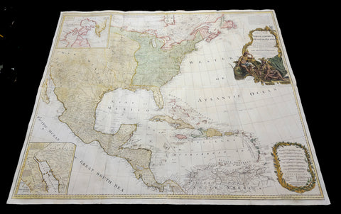
1786 (1794) Thomas Pownall & Sayer Large Revolutionary War Map North America
Antique Map
- Title : A New Map of North America with the West India Islands, divided according to the Preliminary Articles of Peace, Singed at Versailles, 20, jan 1783, wherein are particularly Distinguished The United States, and the Several Provinces, Governments & ca which Compose the British Dominions, Laid down according to the Latest Surveys, and Corrected from the Original Materials of Goverr. Pownall, Membr. of Parlimt....1794
- Size: 47in x 41in (1.20m x 1.050m)
- Condition: (A+) Fine Condition
- Date : 1794
- Ref #: 35672
Description:
A large, extraordinary important, original rare copper-plate engraved and hand coloured map of North America by Governor Thomas Pownell, was engraved and updated in 1786 and updated by Thomas Kitchin in 1794 - dated in cartouche - and published in "A general atlas, describing the whole universe: being a complete collection of the most approved maps extant; corrected with the greatest care, and augmented from the latest discoveries" by Robert Sayer, Laurie and Whittle.London.
This map was first issued by Emmanuel Bowen and John Gibson in 1755 and went through numerous iterations over the next 40 years. This edition was issued shortly after the end of the American Revolutionary War and the Treaty of Paris in 1783. The map details the newly formed United States of America in Green, the British & French dominions in Canada in Red, plus the extensive Spanish territories of from Florida, Louisiana Mexico and Central America. As one might expect from a map of this size, the detail throughout is extraordinary.
General Definitions:
Paper thickness and quality: - Heavy and stable
Paper color : - off white
Age of map color: - Original
Colors used: - Yellow, green, blue, pink
General color appearance: - Authentic
Paper size: - 47in x 41in (1.20m x 1.050m)
Plate size: - 46in x 40in (1.10m x 990mm)
Margins: - Min 1in (20mm)
Imperfections:
Margins: - None
Plate area: - Light toning & offsetting
Verso: - Light age toning.
Background:
This monumental 1794 map of North America by Governor Thomas Pownell was issued shortly after the end of the American Revolutionary War. The United States at this time extended from the Pacific to the Mississippi River and from Georgia to the Great Lakes and Maine. The early state boundaries roughly conform to their original colonial charters. Virginia, North Carolina, and South Carolina are drawn with indefinite western borders, suggesting claims to further unexplored land beyond the Appellation Mountains. By this time most of the boundary issues in the New England states had been resolved, though there remained some vagaries regarding the Massachusetts Connecticut border and, though Vermont is noted textually, its boundaries are not drawn in. At this time there were also some unresolved issues regarding the national borders between Maine and Nova Scotia. In Pennsylvania, the western border displays some surveying confusions that would not be resolved until the early 1800s and the creation of Ohio.
It is beyond the old colonial centers where this map really gets interesting. Pownall offers copious notations on the lands and territories between the Appellation range and this Mississippi River. In some cases he offers commentary on the various indigenous tribes including the Creeks, Chickasaws, Chocktaws, Senekas, Eriez, Delawares, Shawnee, Iroquois, Algonquians, Ottawas and others. The cartographer was clearly concerned with the development of these western regions and offers copious commentary on fit sites for factories, the alliances and temperaments of tribes, and the navigability of various river systems, particularly the Mississippi and Ohio.
The Great Lakes are mapped with considerable accuracy though several apocryphal islands do appear in Lake Superior. The most notable of these are Phelipeaux and Pontchartrain. Phelipeaux Island first appeared in French maps of this region in the 1740s. Later it was mentioned as a boundary marker in the 1783 Treaty of Paris which ended the American Revolutionary War. The nonexistence of these islands was not conclusively proven until about 1820.
To the west of the Mississippi we pass into the largely unknown lands of the Great Plains. In what is roughly modern day Missouri, between Memphis and St. Louis, there is an interesting note suggesting that this region is Full of Mines, with a secondary note suggesting that these mines gave rise to the Mississippi Scheme of 1719. This refers to the Mississippi Company (Compagnie du Mississippi) or, as it was more commonly known the Indies Company (Compagnie d Occident). This organization was part of a French investment plan comparable to the South Seas Company which was developing contemporaneously in England. The Mississippi Companys charter was to trade the riches of the Louisiana Territory. The main proponent of the Mississippi Company, John Law, greatly exaggerated the wealth of Louisiana by describing a rich mining region easily accessible along the Mississippi from New Orleans. This resulted in a stock buying rush which disproportionately overvalued Mississippi Company stock, resulting in one of the world's first Bubble Economies.
Further North, along the northern border between the United States and British America (Canada), Rain Lake, the Lake of the Woods, and Lake Winnepeg are noted. This region was a hotbed of exploration throughout the 18th century. French and English concerns in the New World were desperate for access to the Pacific and the rich Asian markets. These markets had long been dominated by the Spanish who had easy access to the Pacific via Mexico and South America. The French and English set their hopes on a Northwest Passage. By the late 18th century the search for a route through the high Arctic had long been abandoned. Instead, explorers and theoretical cartographers believed that a water route might be found among the elaborate network of lakes and rivers that meandered through central Canada. Our map shows evidence of some of this exploration, particularly the travels of the Quebec born Pierre de La Verendrye and his sons around Lake Alimipigon, the Lake of the Woods (Lake Minitti) and Lake Winnipeg (Lake Ouinipigon).
As we progress even further west, passing out of Louisiana into the Spanish holdings we begin to see significant mapping - both conjectural and factual. The Spanish had long been passively active in the exploration of New Mexico. Though no concerted effort had been put forth to map the region, various missionaries and territorial governors had, over roughly 200 years of occupation added considerable data, both fact and fiction to the cartographic picture. Numerous American Indian groups are noted including the Pimas, the Apaches ,the Navajo and others. Along the Rio del Norte or upper Rio Grande there are a quantity mission stations including the regional capital of Santa Fe.
Just to the west of these missions we begin to enter more mythical territory and both Cibola and Teguayo are noted. Cibola and Teguayo are both associated with the legendary Seven Cities of Gold. It was believed that in 1150 when Merida, Spain, was conquered by Moors ,the city's seven bishops fled to unknown lands taking with them much of the citys riches. Each Bishop supposedly founded a great city in a far away place. With the discovery of the New World and the fabulous riches plundered by Cortez and Pizarro, the Seven Cities became associated with New World legends. Coronado, hearing tales of the paradise-like mythical Aztec homeland of Azatlan somewhere to the north of Mexico , determined to hunt for these cities in what is today the American southwest. In time indigenous legends of rich and prosperous lands became attached to the seven cities. Two of these appear on our map - Cibola and Teguayo.
The gulf of Mexico, the West Indies, and the Caribbean are charted with considerable and typical accuracy. Notes numerous offshore shoals, reefs, and other dangers - especially around the Bahamas. Also describes several important shipping routes, particularly the former routes of Spanish galleons from Veracruz to Havana, the route from Cartagena to Havana, and the route from Cartagena to Europe.
There are also two particularly interesting insets. The first, in the upper left quadrant, depicts the Canadian arctic, particularly the Hudson and Baffin Bays. Notes all of the most recent discoveries in this region and offers interesting notes such as If there is Northwest Passage it appears to be through one of these inlets. In the northwestern quadrant of this inset, the supposed discoveries of Admiral de Fonte are included, despite a notation that they are Imaginary.
The second inset of interest in located in the lower left quadrant. This smaller maps depicts the northern parts of the Gulf of California and the Colorado River Delta based upon the explorations of the Jesuit Father Eusebius Francis Kino. The actual cartography of this region has been vague since the mid 17th century when it was postulated that California must be an Island. It was not until Kinos historic expedition, recorded here, that Baja California was conclusively proven to be a peninsula.
A magnificent title cartouche appears in the upper right quadrant. The cartouche, which angles around Bermuda, depicts two stylized American Indians surrounded by the presumed flora and fauna of the new world. These include a small monkey, a parrot, and a jaguar. Above the cartouche is a textual quotation from Article III of the Treaty of Paris, affirming the rights of the United States to access the rich cod fields of Newfoundlands Grand Banks.
The Treaty of Paris, signed in Paris by representatives of King George III of Great Britain and representatives of the United States of America on September 3, 1783, ended the American Revolutionary War. The treaty set the boundaries between the British Empire in North America and the United States, on lines exceedingly generous to the latter. Details included fishing rights and restoration of property and prisoners of war.
This treaty and the separate peace treaties between Great Britain and the nations that supported the American cause—France, Spain, and the Dutch Republic—are known collectively as the Peace of Paris. Only Article 1 of the treaty, which acknowledges the United States existence as free, sovereign, and independent states, remains in force.
Thomas Pownall 1722 - 1805 was a British scholar, statesman and soldier active in the colonial administration of North America just prior to the American Revolutionary War. Pownell was born in England and educated at Trinity College, Cambridge. After graduation he was employed by his brother, John Pownall, at the office of the Lords Commissioners of Trade and Plantations, which oversaw British economic interests in its North American colonies. In 1753, Pownall was appointed secretary to the governor of New York, Sir Danvers Osborne. Osborne, himself having be only recently appointed to the position, committed suicide shortly after taking office. Despite this setback, Pownall remained in America and devoted himself to studying and researching the colonies. In the process Pownall became close lifelong friends with Benjamin Franklin and other New World luminaries. He also published several notable works on the colonial administration of North America. In 1757 Pownall was appointed Governor of the Massachusetts Bay colony. In this position he frequently found himself at odds with the restrictive policies of the Board of Trade. It was not long before he was pushed out of office and, declining the governorship of Jamaica, reassigned to South Carolina. Despite nominally holding the governorship of South Carolina, Pownall never visited the colony. Instead he returned to England where he eventually became a member of Parliament. In Parliament, he advocated for reduced taxes towards the colonies - had he been heeded, the American Revolution may have never happened. Pownall retired from public life around 1780, but continued to pursue his scholarly interests. Pownalls research contributed significantly to several important maps and scholarly work on North America.
Laurie and Whittle 1794 - 1858 based in London, were map and atlas publishers active in the late 18th and early 19th century. Generally considered to be the successors to the Robert Sayer firm, Laurie and Whittle was founded by Robert Laurie (c. 1755 - 1836) and James Whittle (1757-1818). Robert Laurie was a skilled mezzotint engraver and is known to have worked with Robert Sayer on numerous projects. James Whittle was a well-known London socialite and print seller whose Fleet Street shop was a popular haunt for intellectual luminaries. The partnership began taking over the general management of Sayers firm around 1787; however, they did not alter the Sayer imprint until after Sayers death in 1794. Apparently Laurie did most of the work in managing the firm and hence his name appeared first in the Laurie and Whittle imprint. Together Laurie and Whittle published numerous maps and atlases, often bringing in other important cartographers of the day, including Kitchin, Faden, Jefferys and others to update and modify their existing Sayer plates. Robert Laurie retired in 1812, leaving the day to day management of the firm to his son, Richard Holmes Laurie (1777 - 1858). Under R. H. Laurie and James Whittle, the firm renamed itself Whittle and Laurie. Whittle diedin 1818, and thereafter the firm continued under the imprint of R. H. Laurie. After Lauries death the publishing house and its printing stock came under control of Alexander George Findlay, who had long been associated with Laurie and Whittle. Since, Laurie and Whittle has passed through numerous permeations, with part of the firm still extant as an English publisher of maritime or nautical charts, Imray, Laurie, Norie and Wilson Ltd. The firm remains the oldest surviving chart publisher in Europe.
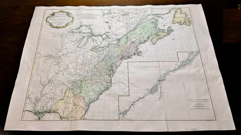
1755 D 'Anville Large Antique Map of North America, Great Lakes, 13 Colonies
Antique Map
- Title : Canada Louisiane et Terres Anglois Par Le Sr. D Anville...MDCCLV
- Ref #: 61140
- Size: 52in x 38in (1.32m x 960mm)
- Date : 1755
- Condition: (A+) Fine Condition
Description:
This magnificent, scarce, very large (52in x 38in) hand coloured & highly detail map of North America was engraved in 1755 - dated in the title cartouche - by George De La Haye and was published by Jean Baptiste Bourguignon D Anville in his large elephant folio atlas Atlas Generale.
Geopolitically this map is extremely significant drawn as war between the Global Powers of the day, France, England & Spain, was breaking, known in Europe as the Seven Year War known in North America as the French & Indian war. (Please see below for more detail)
This map rivals John Mitchells "A Map of the British and French Dominions in North America published in 1755" - considered to be one of the most significant maps of North America published in the 18th & 19th centuries (a 1st edition of Mitchells map is currently for sale for $165,000).
I have included an image of the Mitchell map for comparison. The D Anville map is considered by many to be cartographically superior to the Mitchell map, at a fraction of the price.
General Description:
Paper thickness and quality: - Heavy and stable
Paper color: - White
Age of map color: - Early & later
Colors used: - Pink, yellow, green
General color appearance: - Authentic
Paper size: - 52in x 38in (1.32m x 960mm)
Plate size: - 45in x 35in (1.12m x 890mm)
Margins: - Min 1in (25mm)
Imperfections:
Margins: - None
Plate area: - Light ceasing along folds
Verso: - Very small worm holes
Background: This extraordinary map of the eastern half of North America extends from Newfoundland, Canada to St. Augustine, Florida, stretching westward beyond the Mississippi as far as modern day Texas. The map includes both the original colonial colonies along the Atlantic seaboard from Maine to Georgia and the French claims in Louisiana (the Mississippi Valley) and modern day Canada. Florida is acknowledged as a Spanish enclave. Elevation is rendered in profile with fortifications, towns, and American Indian villages identified. A large inset map centres on the course of the St. Lawrence River from the Isle Aux Coudres to Lake Ontario.
The is a very significant map, drawn from a definitive French perspective, defining the territorial alignments and claims within North America shortly following the outbreak of the French and Indian War, considered to be a New World reflection of the European Seven Years War. It is however notable that it began before the larger hostilities in Europe and most of the major battles involved primarily parties only loosely aligned with the French or English - most specifically American Indians and lawless frontiersman, who had their own political agenda.
The war began with French incursions into western Pennsylvania and other territories claimed simultaneously by the French, English and American Indian forces. Just prior to the war, the French, in the interest of broadening their hold on the lucrative fur trade, established a series of forts, all of which are here noted, along the length of the Mississippi and further east, including Fort Duquesne (here Fort de Quene, Pittsburgh), Fort de la Presquisle, and for Le Beouf (here, Fort de la Riv Jaus Beufs).
The map also recognizes British claims, only inland as far as the Appalachian Mountains, beyond which place names take on a noticeably French character. These last three forts occupied particularly contested territory under the control of the powerful British allied Iroquois League. The most contested of these was Fort Duquesne (modern day Pittsburgh) in direct opposition to another fort then being constructed by the Ohio Company, a trading and land speculation firm established by prominent Virginia colonials, including George Washington. The Virginian colonial governor responded to Duquesne by sending then Lieutenant George Washington and a band of Virginia militiamen to harass the French. The resulting Jumonville Affair, in which Washington oversaw an attack on a French Canadian diplomatic forces led by Joseph Coulon de Villiers de Jumonville, to warn the Ohio Company fort builders away from French claimed territory. The slaying of Jumonville and several other French diplomats prompted a response from French forces at Fort Duquesne, leading to Washingtons retreat and construction of Fort Necessity, really little more than a palisaded shack, marked here just south of Fort Duquesne. These events, all of which occurred in May of 1754, were said to have increased hostilities in Europe and led to the start of the Seven Year War in 1755.
Beyond the political agenda of this map, is the map itself, being one of the finest and most heavily detailed maps of North America published in the mid 18th century. Ranking alongside the large 1755 Mitchell map in detail but judged by many as cartographically superior. Drawing on both French and British cartographical detail, D Anville identifies countless American Indian tribes, many of which, like the Sioux and Missouri, the British had only vague knowledge. Moreover, he also includes detail such as swamps, rapids, fords, abandoned villages, and even the ancient remnants of mound builder culture in the Ohio Valley. D Anville notably does not include Mitchells fictional Lake Superior islands.
This map was originally published to accompany the pamphlet entitledMemoire sur la carte intitulee: Canada, Louisiane, & Terres angloises and was also published in four parts for D Anvilles Atlas General.
These large maps are hard to find in such good condition and make fantastic historical reference tools due to the size and high level of detail as with all D Anvilles work. (Ref: Tooley, M&B)
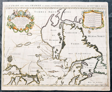
1696 Alexis Hubert Jaillot Large Antique Map North America, Canada & Great Lakes
Antique Map
- Title : Le Canada ou Partie de la Nouvelle France....Hubert Jaillot....1696
- Size: 24 3/4in x 20 1/2in (680mm x 520mm)
- Condition: (A) Very Good Condition
- Date : 1696
- Ref #: 51014
Description:
This large original copper plate engraved, hand coloured antique map of North America, Canada and the Great Lakes was engraved in 1696 - dated in title - and was published by Alexis Hubert Jaillot in his monumental Atlas Nouveau.
General Definitions:
Paper thickness and quality: - Heavy and stable
Paper color : - off white
Age of map color: - Original
Colors used: - Yellow, green, blue, pink
General color appearance: - Authentic
Paper size: - 35 1/2in x 23in (900mm x 585mm)
Plate size: - 34 1/2in x 22 1/2in (875mm x 570mm)
Margins: - Min 1/2in (15mm)
Imperfections:
Margins: - Light age toning in margin
Plate area: - Light age toning and offsetting
Verso: - 4 small re-enforcements on verso
Background:
Nice example of Jaillot's map of Hudson's Bay, Canada, the Great Lakes, and the regions then controlled by French Missionaries and Traders.A number of forts are located in and around Hudson Bay. These would be the forts recently seized from the English Hudson Bay Company in 1686 an which at the time of the publication of the map were the subject of active conflict between the French and English forces in the region.
The four short notes on the map identify four areas of settlement and fur trading activities:
Poste pour couper les Sauvages par le haut de la traite de Tadoussac et les empêcher de descendre à la Baye de Hudson. (Translation: Post to intercept the Indigenous peoples at the upper Tadoussac trade route and prevent them from descending to Hudson Bay.") This section indicates a strategic location near Tadoussac, an important trading post established in 1600 by Pierre de Chauvin de Tonnetuit. Tadoussac was a key site for the fur trade between the French and Indigenous peoples. The notation reveals efforts to control the movement of Indigenous groups, particularly in the context of the fur trade, by preventing them from reaching the lucrative markets of Hudson Bay. The neighboring English settlement is Rupert House (Fort Rupert).
Poste du Sr. de S. Germain pour couper pres que tous les Sauvages du Nort et les empêcher de descendre à la Baye de Hudson. (Translation: "Post of Sr. de S. Germain to intercept nearly all the Indigenous peoples from the North and prevent them from descending to Hudson Bay."). Highlighting another strategic outpost, this section references Daniel Greysolon, Sieur DuLhuta French soldier and explorer who was largely responsible for establishing French control over the country north and west of Lake Superior.. This post aimed to control northern Indigenous trade routes and limit their access to Hudson Bay, thereby securing French trade interests in the region, possibly in coordination with the Compagnie des Cent-Associés (Company of One Hundred Associates), established in 1627 to manage the colony's resources. The neighboring English settlement includes Moose Factor (Fort Saint-Louis).
Poste du Sr. Duluth pour empêcher les Assiniboels et autres Sauvages de descendre à la Baye de Hudson. (Translation: "Post of Sr. Duluth to prevent the Assiniboine and other Indigenous peoples from descending to Hudson Bay."). This notation points to a post established by Daniel Greysolon, Sieur du Lhut (Duluth). His efforts in the 1670s and 1680s to establish posts and alliances with Indigenous groups were crucial in French attempts to dominate the fur trade by controlling access to Hudson Bay.
Poste François decouvert et occupé par la Compagnie qui s'est formée en Canada pour la Baye de Hudson. (Translation: "French post discovered and occupied by the Company formed in Canada for Hudson Bay.").
Hudson Bay Company and French Fur Trading Conflicts in the 17th Century
In the 17th century the French had a de facto monopoly on the Canadian fur trade. Two French traders, Pierre-Esprit Radisson and Médard des Groseilliers (Médard de Chouart, Sieur des Groseilliers), Radisson's brother-in-law, learned from the Cree Indians that the best fur country lay north and west of Lake Superior. They sought French backing for a plan to set up a trading post on Hudson's Bay. Thee French refused. In 1659, without official support, Radisson and Groseilliers set out for the upper Great Lakes basin. A year later they returned with premium furs, evidence of the potential of the Hudson Bay region. Subsequently, they were arrested for trading without a license and fined, and their furs were confiscated.
Radisson and Groseilliers approached a group of English businessmen in Boston, who agreed on the plan's merits but their speculative voyage in 1663 failed when their ship ran into pack ice in Hudson Strait. Colonel George Cartwright learned of the expedition and brought the two to London in 1665, where they gained the sponsorship of Prince Rupert. In 1668 the English expedition acquired two ships, the Nonsuch and the Eaglet, departing on June 5, 1668. Once in James Bay, the expedition established the first fort on Hudson Bay, Charles Fort, at the mouth of the Rupert River. (It was later known as Rupert House, and developed as the community of present-day Waskaganish, Quebec.) After a successful trading expedition over the winter of 1668–69, Nonsuch returned to England with the first cargo of fur, which was sold to Thomas Glover, one of London's most prominent furriers.
The Governor and Company of Adventurers of England Trading into Hudson's Bay was incorporated on May 2,1670, with a royal charter from King Charles II, graining the company a monopoly over the region drained by all rivers and streams flowing into Hudson Bay in northern Canada. The area was named "Rupert's Land".
The HBC established six posts between 1668 and 1717. Rupert House (1668), Moose Factory (1673) and Fort Albany (1679) were erected on James Bay and Fort Severn (1689), York Factory (1684) and Fort Churchill (1717) on Hudson's Bay.
The early coastal factory model of the English contrasted with the system of the French, who established an extensive system of inland posts at native villages, and sent traders to live among the tribes of the region, learning their languages and often forming alliances through marriages with indigenous women. In March 1686, the French sent a raiding party under the Chevalier des Troyes to capture the HBC posts along James Bay. The French appointed Pierre Le Moyne d'Iberville, who had shown great heroism during the raids, as commander of the company's captured posts. In 1687 an English attempt to resettle Fort Albany failed due to strategic deceptions by d'Iberville. After 1688 England and France were officially at war, and the conflict played out in North America as well. D'Iberville raided Fort Severn in 1690 but did not attempt to raid the well-defended local headquarters at York Factory. In 1693 the HBC recovered Fort Albany; d'Iberville captured York Factory in 1694, but the company recovered it the next year.
In 1697, d'Iberville again commanded a French naval raid on York Factory. On the way to the fort, he defeated three ships of the Royal Navy in the Battle of Hudson's Bay (September 1697), the largest naval battle in the history of the North American Arctic. D'Iberville's depleted French force captured York Factory by laying siege to the fort and pretending to be a much larger army. The French retained all of the outposts except Fort Albany until 1713. (A small French and Indian force attacked Fort Albany again in 1709 during Queen Anne's War but was unsuccessful. The economic consequences of the French possession of these posts for the company were significant; HBC did not pay any dividends for more than 20 years. (Ref: Stevenson; Tooley; M&B)
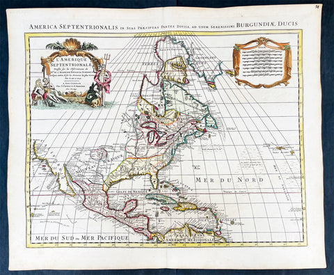
1730 Delisle and Covens & Mortier Foundation Antique Map of North America
Antique Map
- Title : L Amerique Septentrionale dressee sur les Observations de Mrs. De L Academie Royale des Sciences & quelques autres & sur les Memoires les plus recens Par G De L Isle A. Amsterdam Chez I Covens & C Mortier Avec Privilege.
- Ref #: 93501-1
- Size: 25 1/2in x 21 1/2in (650mm x 540mm)
- Date : 1700 (1730)
- Condition: (A+) Fine Condition
Description:
This is without doubt one of the most important foundation maps, of North America, published in the early to mid 18th century. This large original hand coloured copper-plate engraved antique map by Johannes Covens & Pierre Mortier, after Guillaume Delisle, that was published in 1730 in Atlas nouveau de dicerses cartes choisies des Meilleurs Geographes comme Sanson, G De Lisle &c....A Amsterdam.....
The first edition of this map was mistakenly dedicated to Nicolas Sanson, in the title. This oversight was corrected to Delisle in this 1730 edition.
This map is beautiful with original borders beautiful hand colouring on heavy stable paper.
Covens & Mortier (fl 1721-1866) was an eighteenth century cartographic publishing house. The company was founded by Johannes Covens (1697-1774) and Cornelis Mortier (1699-1783) and was located in Vijgendam in Amsterdam .
The collaboration between the two men began after the death of Pieter Mortier (1661-1711), son of a French political refugee. In 1690, Mortier obtained the privilege of distributing maps and atlases from French publishers, in the Netherlands . His widow continued business until his death in 1719 . His son Cornelis took over the business, under the name of his father.
In November 1721 Cornelis Mortier founded a company with Johannes Covens I. He was married in the same year to Corneliss sister. Thus the company of Covens & Mortier was born.
General Definitions:
Paper thickness and quality: - Heavy and stable
Paper color : - off white
Age of map color: - Original & later
Colors used: - Yellow, green, blue, pink
General color appearance: - Authentic
Paper size: - 25 1/2in x 21 1/2in (650mm x 540mm)
Plate size: - 23in x 19in (585mm x 490mm)
Margins: - Min 1in (25mm)
Imperfections:
Margins: - None
Plate area: - None
Verso: - None
Background:
There are many reasons why this rare 1st edition foundation map is important. It contains detail of radical changes both to the interior of North America and helps debunk many fundamentally held ideas of the coastlines. Some of these ideas included The Great lakes, California as an island and previously invented ideas of the interior, NW & NE coastlines.
Specifically the shape of the Great Lakes are changed based on information from the great Italian cartographer Vincenzo Coronelli.
The Mississippi valley is well developed with recent French settlement of d\\\'Iberville at Bilochy and the forts at Bon Secours and St Louis. The map also corrects the error of the western swing of the lower part of the Mississippi River, moving its mouth to essentially its correct position on the Gulf of Mexico.
Delisle has also corrected longitude positions and was the first to revert to a peninsular form for California. He stops his western coast at Cape Mendocin and is the first map to show the Saragossa Sea.
The map also illustrates the routes of explorers such as Cortez, Drake, D\\\'Olivier, Gaeten and Mendana, and indicates the locates of a number of Indian tribes, including the Apaches.
As this is a French map we see many of the French strong points in the NE such as Tadousac, Quebec, Fort Sorel, Montreal & Fort Frontenac included. The English settlements are confined to the east of the Alleghenies, with Fort and River Kinibeki as the border between New England and Arcadia.
Such was the improvement of this map, and the sterling reputation of Delisle, that within a few years other publishers issued their own copies of the map, which continued to appear until the 1780s. The importance of this map cannot be overstated in the progression of American cartography. (Ref: M&B; Tooley)
1756 J B Nolin Large Rare Antique Map of North America, Great Lakes, French Indian War (1754-63)
Antique Map
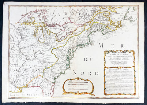
- Title : Carte Du Canada et de La Louisiane Qui Forment La Nouvelle France et Des Colonies Anglois . . . 1756
- Date : 1756 (dated)
- Condition: (A) Very Good Condition
- Ref: 93505
- Size: 30in x 21 1/2in (760mm x 555mm)
Description:
This large, magnificent and very rare original copper plate engraved antique pre-revolutionary French Indian war map of North America was engraved by Jean Baptist Nolin in 1756, dated in cartouche.
This is an important and rare pre-revolutionary French Indian war map, which focuses on the territorial claims of France and Great Britain. Highly detailed showing many early towns and cities, some forts, Indian villages, and tribal territory. Includes the following French text describing the territories claimed by France, Great Britain & Spain in North America: Description du Canada below the cartouche,
This highly detailed map focuses on the territorial claims of France and Great Britain during the French Indian War (1754-63) highly detailed, with a heavy emphasis on the mapping of the Great Lakes. A must for any collector of maps of North America.
We have found records of only 7 sales of this map since 1983, and currently there is only one other to be found for sale.
General Definitions:
Paper thickness and quality: - Heavy and stable
Paper color : - off white
Age of map color: - Original & later
Colors used: - Yellow, green, blue, pink
General color appearance: - Authentic
Paper size: - 30in x 21 1/2in (760mm x 555mm)
Plate size: - 28in x 20 1/2in (720mm x 520mm)
Margins: - Min 1in (25mm)
Imperfections:
Margins: - Small repair to left margin, not affecting the image
Plate area: - Old small repair to top centerfold
Verso: - Re-enforce along centerfold
Background:
The French and Indian War (1754–63) comprised the North American theatre of the worldwide Seven Years War of 1756–63. It pitted the colonies of British America against those of New France. Both sides were supported by military units from their parent countries, as well as by American Indian allies. At the start of the war, the French North American colonies had a population of roughly 60,000 settlers, compared with 2 million in the British North American colonies. The outnumbered French particularly depended on the Indians. The European nations declared war on one another in 1756 following months of localized conflict, escalating the war from a regional affair into an intercontinental conflict.
The name French and Indian War is used mainly in the United States. It refers to the two enemies of the British colonists, the royal French forces and their various American Indian allies. The British colonists were supported at various times by the Iroquois, Catawba, and Cherokee, and the French colonists were supported by Wabanaki Confederacy members Abenaki and Mikmaq, and Algonquin, Lenape, Ojibwa, Ottawa, Shawnee, and Wyandot.
British and other European historians use the term the Seven Years War, as do English-speaking Canadians. French Canadians call it La guerre de la Conquête (the War of the Conquest) or (rarely) the Fourth Intercolonial War.
Fighting took place primarily along the frontiers between New France and the British colonies, from Virginia in the south to Newfoundland in the north. It began with a dispute over control of the confluence of the Allegheny River and Monongahela River called the Forks of the Ohio, and the site of the French Fort Duquesne in Pittsburgh, Pennsylvania. The dispute erupted into violence in the Battle of Jumonville Glen in May 1754, during which Virginia militiamen under the command of 22-year-old George Washington ambushed a French patrol.
In 1755, six colonial governors in North America met with General Edward Braddock, the newly arrived British Army commander, and planned a four-way attack on the French. None succeeded, and the main effort by Braddock proved a disaster; he lost the Battle of the Monongahela on July 9, 1755 and died a few days later. British operations failed in the frontier areas of Pennsylvania and New York during 1755–57 due to a combination of poor management, internal divisions, effective Canadian scouts, French regular forces, and Indian warrior allies. In 1755, the British captured Fort Beauséjour on the border separating Nova Scotia from Acadia, and they ordered the expulsion of the Acadians (1755–64) soon afterwards. Orders for the deportation were given by William Shirley, Commander-in-Chief, North America, without direction from Great Britain. The Acadians were expelled, both those captured in arms and those who had sworn the loyalty oath to His Britannic Majesty. Indians likewise were driven off the land to make way for settlers from New England.
The British colonial government fell in the region of modern Nova Scotia after several disastrous campaigns in 1757, including a failed expedition against Louisbourg and the Siege of Fort William Henry; this last was followed by Indians torturing and massacring their British victims. William Pitt came to power and significantly increased British military resources in the colonies at a time when France was unwilling to risk large convoys to aid the limited forces that they had in New France, preferring to concentrate their forces against Prussia and its allies in the European theater of the war. Between 1758 and 1760, the British military launched a campaign to capture the Colony of Canada (part of New France). They succeeded in capturing territory in surrounding colonies and ultimately the city of Quebec (1759). The British later lost the Battle of Sainte-Foy west of Quebec (1760), but the French ceded Canada in accordance with the Treaty of Paris (1763).
The outcome was one of the most significant developments in a century of Anglo-French conflict. France ceded to Great Britain its territory east of the Mississippi. It ceded French Louisiana west of the Mississippi River (including New Orleans) to its ally Spain in compensation for Spains loss to Britain of Florida. (Spain had ceded Florida to Britain in exchange for the return of Havana, Cuba.) Frances colonial presence north of the Caribbean was reduced to the islands of Saint Pierre and Miquelon, confirming Great Britains position as the dominant colonial power in eastern North America.
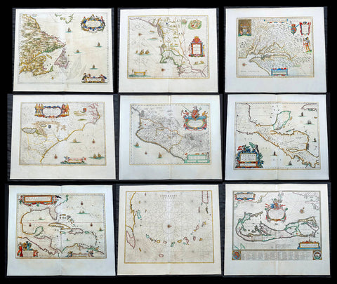
1662 Joan Blaeu Complete Set of 9 Antique Maps of North America from Atlas Major, 1st Edition
Antique Map
- Titles:
1. Extrema Americae....Terra Nova Francia;
2. Nova Belgica Et Anglia Nova;
3. Nova Virginiae Tabula;
4. Virginiae partis australis, et Floridae;
5. Nova Hispania;
6. Yucatan...Guatimala;
7. Insulae Americanae;
8. Canibales Insulae;
9. Mappa Aestivarum Insularum Alias Barmudas - Sizes: 24in x 20 1/2in (610mm x 520mm)ea
- Condition: (A+) Fine Condition
- Date: 1662
- Ref #: BlaeuNA 1662
Description:
This is a unique opportunity to acquire a complete set of 9 maps of North America published by Joan Blaeus in the monumental & rare 1st 1662 Latin edition of Atlas Major. The maps cover the geographical detail of Canada, North America, Mexico, The Caribbean & Central America. Please see the background section below for details of each map. All maps have wide original margins & colour on strong sturdy paper.
Joan Blaeus 11 volumes of Atlas Major, is considered by many to be the greatest atlas set ever published. It excels in comprehensiveness, engraving, color, and overall production. The first edition was published in Latin in 1662 and was subsequently published in French, Dutch, German, and Spanish over the next 10 years.
On the 23rd of February 1672, a fire broke out in central Amsterdam, that ended the reign of one of the greatest & most prolific publishers of printed maps and atlases in publishing history. The Blaeu family had reached its zenith 10 years previously, with the publication of its greatest achievement, the Atlas Major or Great Atlas, consisting of 11 volumes, with geographical detail reflecting many of the achievements of the Golden Age of the United Netherlands. Blaeus Atlas Major were the most expensive books printed in the 17th century.
General Definitions:
Paper thickness and quality: - Heavy and stable
Paper color : - off white
Age of map color: - Original
Colors used: - Blue, pink, red, green, yellow
General color appearance: - Authentic
Paper size: - 24in x 20 1/2in (610mm x 520mm)
Plate size: - Various, pls see below
Margins: - Min 1in (25mm) min
Imperfections:
Margins: - Pls see below
Plate area: - Pls see below
Verso: - Pls see below
Background:
1. Extrema Americae ( Eastern Canada) - Rare only published in Atlas Major. Derived mainly from the Samuel de Champlain Nouvelle France map of 1632, this map reflects the growing financial importance of the waters of New France to Europe.
Plate: 22 1/2in x 17 3/4in.
Condition: Age toning, text show-through & browning to image.
2. Nova Belgica Et Anglia Nova (New England) - NE America, centering on New York and Manhattan from Virginia to the St Lawrence River. This map is noted for the fact that its primary source is the first manuscript figurative map of Adriaen Block from 1614. Indeed it is the first full representation of it in print. It is one of the earliest to name Nieu Amsterdam. Block, a Dutch fur trader, explored the area between Cape Cod and Manhattan, examining the bays and rivers along the way.
Plate: 19 1/2in x 15 1/2in
Condition: Age toning, text show-through & browning to image.
3. Nova Virginiae Tabula (John Smiths Virginia & Chesapeake Bay) This map was printed from a plate engraved by Dirk Grijp from a previous plates by Henricus Hondius.
Plate: 19in x 15in
Condition: Light age toning
4. Virginiae partis australis, et Floridae Virginia, the Carolinas & Georgia.
Plate: 20in x 15in
Condition: Light age toning
5. Nova Hispania et Nova Galicia Western Mexico
Plate: 19 1/2in x 15 1/2in
Condition: Light age toning
6. Yucatan...Guatimala (Yucatan, Central America) Rare only published in Atlas Major.
Plate: 20 1/2in x 16 1/2in
Condition: Light age toning
7. Insulae Americana (GOM, Caribbean)
Plate: 20 1/2in x 15in
Condition: Light age toning
8. Canibales Insulae (Lesser Antilles Islands) Rare, printed only in Atlas Major
Plate: 21in x 16 1/2in
Condition: Age toning
9. Mappa Aestivarum Insularum Alias Barmudas Dictarum Bermuda. Like all 17th century maps of Bermuda this map is based ultimately on the survey made by John Norwood, of the Bermuda Company, in 1618 in the form as published by the English map-maker John Speed in 1627.
Plate: 21in x 16in
Condition: Light age toning
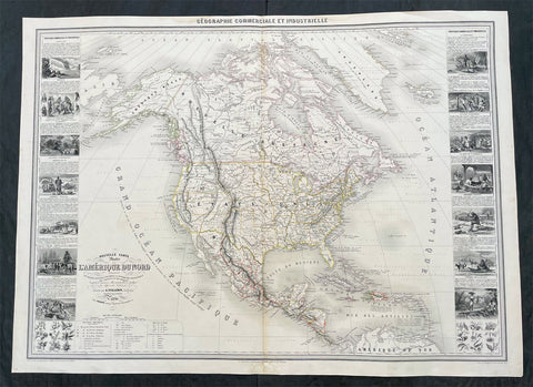
1857 Alexandre Vuillemin Large Antiqque Map of North America...Beautiful
Antique Map
- Title : Nouvelle Carte Illustree L Amerique Du Nord...Vuillemin....1857
- Ref #: 17024
- Size: 35in x 25 1/2in (890mm x 650mm)
- Date : 1857
- Condition: (A) Very Good Condition
Description:
This very large original hand coloured antique lithograph map of North America, with small vignettes of North American peoples surrounding the map, by Alexandre Vuillemin was engraved in 1857, dated in the title, and was published in the 1861 edition of Atlas de geographie commercial et industriel.
This World atlas consisted of 8 double page color maps, dated 1857-1858 by A. Vuillemin, engraved by Langevin and printed by Fatout, Paris. The maps include views, statistical tables and legend. Showing political divisions, capitals, industrial cities, towns, the commercial ports, roads, railroads, canals, fortress and geographical distribution of plants and mineral. Relief shown by hachures and pictorially.
General Definitions:
Paper thickness and quality: - Heavy and stable
Paper color : - off white
Age of map color: - Original
Colors used: - Yellow, green, blue, pink
General color appearance: - Authentic
Paper size: - 35in x 25 1/2in (890mm x 650mm)
Plate size: - 35in x 25 1/2in (890mm x 650mm)
Margins: - Min 1/2in (12mm)
Imperfections:
Margins: - Small repair to bottom margin
Plate area: - None
Verso: - None
Please note all items auctioned are genuine, we do not sell reproductions. A Certificate of Authenticity (COA) can be issued on request.
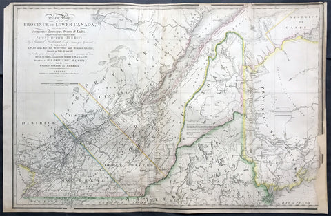
1839 James Wyld Large Antique Map Provinces of Lower Canada, St Lawrence River
Antique Map
- Title : A New Map of the Province of Lower Canada, Describing all the Seigneuries, Townships, Grants of Land, &c. Compiled from Plans deposited in the Patent Office Quebec: by Samuel Holland, Esq. Surveyor General
- Ref #: 50391
- Size: 35 1/4in x 23 1/4in (895mm x 590mm)
- Date : 1839
- Condition: (B) Good Condition
Description:
This large, rare hand coloured original antique map of the provinces of Lower Canada and The St Lawrence River was engraved in 1839 - dated in title - and was published by James Wyld, Charing Cross, London.
This map has undergone some repairs and is priced accordingly. Currently this map is priced as high as $1500.
Background:
This boldly engraved map extends westward to include Lake St. Francis and the extreme tip of Upper Canada, eastward to part of New Brunswick showing the River St. John and beyond, and south to just below the Canadian border with New York and Vermont. It is filled with towns and settlements and individual named townships, roads and trails. It includes several interesting notations and delineates the "Boundary awarded to the King of Holland." Samuel Holland was originally a Dutch surveyor who fought on the side of the British during the French and Indian Wars and served as Surveyor General for the Province of Quebec and the Northern District of America. An infrequently seen issue.
This updated example of this important map of the Lower Province of Canada, first issued by Faden in 1813, which identifies in manuscript the location of the disputed lands southeast of the St. Lawrence River, the so-called "English Line" and "American Line," which would be the subject of an early boundary dispute between the two countries.
The original Faden map included information concerning over 100 land grants on either side of the St. Lawrence River, including the names of Land Owners. Faden's orginal map showed the surveys conducted in 1796-98 along the Scoudiac and Magaguadavic Rivers, in order to ascertain the true location of the St. Croix River. In the present map, there is significant new information and topographcal details, showing the remarkable advancement in the surveying of the region in the 12 years after the publication of Faden's map of 1813.
This new addition includes the District of Maine, Moosehad Lake, Penobscot River and the Bowding County Township and Bingham's Purchase. Whereas the original Faden map had no topographical detail, the present map is a dramatic improvement.
In addition to the topographical improvements, there is now an annotation in the centre of the map identifying the boundary dispute in the region, relating to the existence of two St. Croix Rivers in the region.
The second article of the Treaty of Peace between the US and Britain included the setting of the boundary between the two nations, "From the northwest angle of Nova Scotia, viz., that angle which is formed by a line drawn due north from the source of St. Croix River to the highlands . . ." It later became apparent that there was more than one St. Croix River. A further treaty provision in 1794 appointed a boundary commission, which determined in 1798 that the intended St. Croix was the Schoodiac River and its northern branch Cheputnaticook. The Treaty of Ghent, concluded on December 24, 1814, agreed to provide for a final adjustment of the boundaries described in the Treaty of 1783 that had not yet been determined, which included the boundary line from the source of the River St. Croix to the most north-western point of the Lake of the Woods.
A further commission was appointed to settle the boundary from the St. Croix to the St. Lawrence. Joseph Bouchette and John Lawrence were hired to conduct the surveys and the reports submitted for resolution to a third nation and ultimately resolved by the Webster-Ashburton Treaty of 1842.
The present map shows the two boundary claims at a time when they were not yet fully resolved. (Ref: M&B; Tooley; Clancy)
General Description:
Paper thickness and quality: - Heavy and stable
Paper color: - white
Age of map color: - Original
Colors used: - Yellow, green, blue, red
General color appearance: - Authentic
Paper size: - 35 1/4in x 23 1/4in (895mm x 590mm)
Plate size: - 35 1/4in x 23 1/4in (895mm x 590mm)
Margins: - min. 1/4in (5mm)
Imperfections:
Margins: - Light soiling, repair to bottom right margin , border into image
Plate area: Light soiling, creasing along left fold
Verso: - Light soiling, repairs as noted
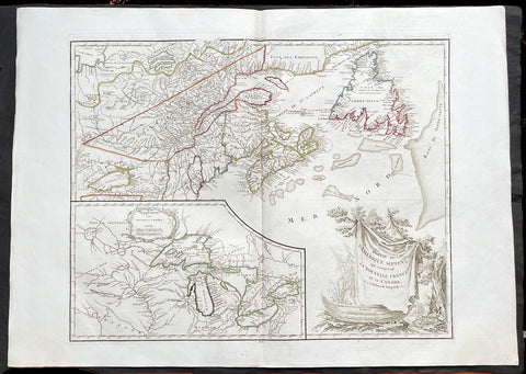
1755 (1778) De Vaugondy Large Antique Map of The Great Lakes America East Canada
Antique Map
- Title : Partie De L Amerique Septent. qui comprend La Nouvelle France ou le Canada...Par le Sr Robert de Vaugondy; Supplement pour Les Lacs du Canada
- Ref #: 17017
-
Condition: (A+) Fine Condition
- Size: 31 1/2in x 22 1/2in (800m x 570mm)
- Date : 1775 (1778)
Description:
This large original beautifully hand coloured, scarce 4th edition, antique map of The Great Lakes of North America, Eastern Canada & part of New England, with border changes from the 1763 Treaty of Paris, was published in 1768 by Robert Du Vaugondy in his Atlas Universal.
One of the nicest examples I have seen, of this scarce and beautiful hand coloured map, on heavy paper with original margins and heavy dark ink denoting an early pressing.
General Definitions:
Paper thickness and quality: - Heavy and stable
Paper color : - off white
Age of map color: - Original
Colors used: - Red, yellow, green, blue
General color appearance: - Authentic
Paper size: - 31 1/2in x 22 1/2in (800m x 570mm)
Plate size: - 24in x 19 1/2in (610mm x 495mm)
Margins: - Min 2in (50mm)
Imperfections:
Margins: - None
Plate area: - None
Verso: - None
Background:
The mapping of the Great Lakes region began in the early seventeenth century, when the first indications of the lakes appeared on maps made by European cartographers. By the mid-1600s, the maps of French Royal Geographer Nicolas Sanson had recognizable depictions of all five Great Lakes. His map is imprecise—Lake Superior lacks its distinctive shape and is unbounded on the west—but Lakes Ontario, Erie, Huron and Michigan can be discerned without difficulty. The lack of any reference to the Mississippi River in Sansons map reflects how little cartographers really knew about the region at the time.
Until the late eighteenth century, maps were made with information acquired in an irregular and imprecise manner. They were not based on formal surveys, but on written records supplemented with sketches by explorers, missionaries and trappers traveling the Upper Midwest. European cartographers had the task of fitting together this often contradictory information and putting the results into the framework of a geographic map. Instead of being mapped in terms of latitude and longitude, prominent places were usually located in relation to other places, which were, of course, similarly positioned. Distances could not be measured with any accuracy at this time, so these maps were liable to gross errors.
The early maps in the Making Maps, Mapping History exhibit provide a capsulized view of the growth of geographical knowledge of the Great Lakes region. As noted above, Sansons map was the first to display all five of the Great Lakes. Vincenzo Maria Coronelli, the cosmographer of the Republic of Venice, used information supplied by Jesuit missionaries in a 1688 map that was the first accurate depiction of the Great Lakes and the Mississippi River. French cartographer Guillaume De LIsle further refined the image and provided an outline that was not substantially improved until surveyors entered the region in the nineteenth century.
The first official government surveys of the Great Lakes were hydrographic surveys conducted by the British Admiralty under the direction of Capt. Henry W. Bayfield. Bayfield spent his entire career surveying the St. Lawrence River and the Great Lakes, beginning with Lake Superior in 1816. The lake-shore city of Bayfield, Wis., was named in honor of this pioneer surveyor.
One of the first acts of the new government of the United States was to establish a system for the orderly settlement of its western lands. Under the Ordinance of 1785, land surveyors went into the western territories in advance of settlement to divide the land into townships of 36 square- mile sections. Though mapping was not the governments primary aim, the surveys provided ample grist for the mapmakers mill, and the regions were, for the first time, mapped with considerable accuracy. The federal government, however, was not yet in the business of making maps for the public. That was left to enterprising individuals, such as Samuel Morrison, Elisha Dwelle and Joshua Hathaway, who produced one of the first topographical maps of the Wisconsin Territory in 1837.
The surveys of the General Land Office served as the basis for the mapping of much of the Great Lakes region from around 1800, when the surveys began, until about 1890, when the U.S. Geological Survey began to map the region again. In some cases, however, the old surveys were not entirely superseded until the mid-20th century. The distinctive feature of maps based on these surveys is the invariable presence of the township grid.
As population and commerce in the Great Lakes region grew, the federal government assumed responsibility for charting the lakes for navigation. The U.S. Lake Survey began in 1841 with an appropriation of $15,000. Before the Civil War, the work was conducted by officers of the Corps of Topographical Engineers. Its initial survey was completed in 1882, but the need for contin- uous revisions caused it to be reactivated a few years later. The Topographical Engineers merged with the U.S. Army Corps of Engineers in 1863, and the Lake Survey remained in the hands of the Corps of Engineers until 1970, when it became part of the newly formed National Ocean Survey (now known as the National Ocean Service).
The U.S. Lake Survey conducted far more rigorous surveys than those of the General Land Office, which used instruments no more sophisticated than a surveyors compass and a Gunters chain. The Lake Survey used an array of precision instruments and employed triangulation to form the geographic framework of the maps. Triangulation allowed the transfer of geographical coordinates from point to point throughout the system and, for the first time, geographical locations were determined with precision. Inland navigation prompted Congress to order a variety of government surveys. During the era of canal building, surveys like the one for the Portage Canal were common. Most of them were conducted by the Corps of Engineers, as were the surveys of the great rivers, such as the Mississippi.
The degree of accuracy accorded Great Lakes navigators was generally not matched on land for many years to come. The task of precisely mapping the United States by covering it with large-scale topographic quadrangle maps was given to the newly formed U.S. Geological Survey (USGS) in the 1880s. John Wesley Powell, the second director of the USGS, stated that the mapping of the United States could be accomplished in 25 years, but that goal was not accomplished until the 1980s. The first topographic maps of Wisconsin appeared in the 1890s, when much of the southeastern part of the state was surveyed. The surveys were quickly done, however, and most of the sheets needed at least minor revision within the next decade. Despite a rapid start, the topographic mapping of Wisconsin bogged down and ultimately was not completed until 1983. Mapping standards changed entirely with the application of aerial photography around 1930. Following World War II, all Wisconsin topographic sheets were derived from photographs.
Today, polar-orbiting satellites with thematic mappers can, in a single day, record images that reveal Great Lakes water quality and temperature, the streets and large buildings of urban areas, and the general health of forests, wetlands and farmlands, including the identity of such crops as corn, hay and alfalfa. The detailed precision of todays computerized Space Age technology no doubt would have astounded Nicolas Sanson—but the seventeenth-century mapmakers ability to create a fairly accurate map of a world he had only heard and read about is equally astounding to twenty-first-century mapmakers.
Please note all items auctioned are genuine, we do not sell reproductions. A Certificate of Authenticity (COA) can be issued on request.
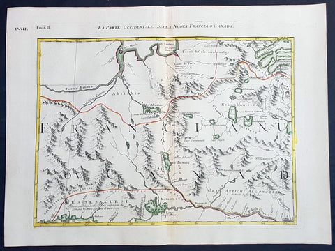
1778 Antonio Zatta & John Mitchell Antique Map of East Quebec & Western Ontario
Antique Map
- Title : La Parte Occidentale Della Nuova Francia o Canada
- Date : 1778
- Condition: (A+) Fine Condition
- Ref: 93512
- Size: 21in x 15 1/2in (535mm x 395mm)
Description:
Description:
This wonderfully executed original copper plate engraved hand coloured antique map of eastern Quebec and Western Ontario - from Lake Superior in the west to Montreal in the east and Hudson Bay in the North was published as Sheet 2, of 12, of Antonio Zattas 1778 re-issue of John Mitchells famous landmark map A Map of the British and French Dominions in North America, With the Roads, Distances, Limits, and Extent of the Settlements was published in Zattas Atlas Atlante Novissimo (1779-1785)
I have included an image of the complete 12 sheet joined map by Zatta as well as an image of Mitchells map.
General Definitions:
Paper thickness and quality: - Heavy and stable
Paper color : - off white
Age of map color: - Original
Colors used: - Yellow, green, blue, pink
General color appearance: - Authentic
Paper size: - 21in x 15 1/2in (535mm x 395mm)
Plate size: - 17 1/2in x 13 1/2in (445mm x 345mm)
Margins: - Min 1in (25mm)
Imperfections:
Margins: - None
Plate area: - None
Verso: - None
Background:
The Mitchell Map by John Mitchell (1711–1768) is considered the most famous map of North America both cartographically and historically, was reprinted several times during the second half of the 18th century. The Mitchell Map was used as a primary map source during the Treaty of Paris for defining the boundaries of the newly independent United States. The map remained important for resolving border disputes between the United States and Canada as recently as the 1980s dispute over the Gulf of Maine fisheries. The Mitchell Map is the most comprehensive map of eastern North America made during the colonial era. Its size is about 6.5 feet (2.0 m) wide by 4.5 feet (1.4 m) high.
John Mitchell was not a professional geographer or map-maker. Son of a wealthy Virginian family in Lancaster County, on Virginia's Northern Neck, he had been educated at Edinburgh University, Scotland; this education included the first two years of the three-year medical program. Returning to coastal Virginia, he practiced as a physician and studied the local botany. Ill health forced Mitchell and his wife to leave Virginia for London in 1746. There, he served as a consultant on exotic plants to noblemen interested in gardens. Also, it was there that Mitchell would make his famous map. Map historians have understandably been interested in why a physician and botanist who had shown no previous interest in map making should make such a large and detailed map.
Until recently, historians have argued that Mitchell was upset by the lack of interest shown by politicians in London about colonial affairs and so set out to warn them about the dangers posed to the British colonies by the French. Mitchell did so, on his own initiative, by making a first map of North America in 1750, which he then showed to the politicians he knew through his botanical and gardening activities. The map so impressed George Montagu-Dunk, 2nd Earl of Halifax, appointed president of the Board of Trade and Plantations in 1748, that Halifax opened up the official archives and solicited new maps from the colonies for Mitchell to make a new and better map. This was the map published in 1755. That is, the motive force for preparations against the French threat is understood to have come from a colonist who sought to take control of the colonies' future on behalf of the other colonists.
A re-examination of the archival evidence indicates, however, that Mitchell made his first map in 1750 at Halifax's behest. Halifax became president of the Board of Trade directly after the conclusion of the War of the Austrian Succession (1744–1748) and its North American component, King George's War. The war had ended in stalemate and a return to the Anglo-French status quo of the 1714 Treaty of Utrecht. In fact, it was a common conviction that it was only a matter of time before another global Anglo-French war would begin, and it was commonly expected that the spark of the new conflict would be the North American colonies. It was then that Halifax latched onto Mitchell as an expert informant on all things colonial; one of his requests, apparently, was for Mitchell to make a new map to show the territorial situation in North America. Certainly, it was only after 1749 that Mitchell's correspondence revealed his new interests in both geography and politics.
Mitchell compiled a first map in 1750 from the materials that he could find in London, in official archives and private hands. It proved to be inadequate. Halifax accordingly ordered the governors of the British colonies to send new maps, which most did. These became the basis, when fitted into the overall geographical frame provided by the maps of the French geographer Guillaume Delisle. Late in 1754, Halifax was using one manuscript copy of Mitchell's second map to successfully promote his political position (no compromise with the French) within the British cabinet in the build-up to the Seven Years' War aka French and Indian War. Halifax also permitted Mitchell to have the map published: it appeared in April 1755, engraved by Thomas Kitchin and published by Andrew Millar.
The published map bore the title A Map of the British and French Dominions in North America. It bore the copyright date of 13 February 1755, but the map was probably not sold to the public until April or even May. Minor corrections to the map's printing plates were made probably during the printing process.
The geographer John Green (né Braddock Mead) criticized Mitchell and his map soon after it appeared, emphasizing two failings with respect to Nova Scotia (an area of particular dispute with the French). Mitchell, Green noted, had used neither the astronomical observations for latitude and longitude made by Marquis Joseph Bernard de Chabert in the 1740s nor a 1715 chart of the Nova Scotia coast. In response, Mitchell released a new version of his map, now with two large blocks of text that described all of his data sources; the new version of the map also adjusted the coastline in line with Chabert's work but rejected the 1715 chart as deeply flawed. This version of the map, which Mitchell referred to as the "second edition," is commonly thought to have appeared sometime in 1757, but advertisements in the (London) Public Advertiser and Gazetteer and London Daily Advertiser on 23 April 1756 clearly indicate that this new map appeared at that time.
The map continued to be corrected and some boundaries updated, even after Mitchell's death in 1768.
Mitchell's map was printed in eight sheets; when assembled, it measures 136 cm by 195 cm (4 feet 6 inches by 6 feet 5 inches; height x width). The initial impressions printed in 1755 have a consistent coloring outlining British colonial claims. Mitchell extended the southern colonies across the entire continent, even over established Spanish territory west of the Mississippi. Mitchell divided up the Iroquois territories (as he understood them, reaching from Lake Champlain [Lac Irocoisia] to the Mississippi, and north of Lake Superior) between Virginia and New York, leaving only a much-reduced territory to the French.
Mitchell's map was expensive but it spawned many cheaper variants that trumpeted Halifax and Mitchell's powerful colonial vision to the British public. One of these, published in December 1755 by "a Society of Anti-Gallicans", restricted the French even further just to Quebec.
The map is liberally sprinkled with text describing and explaining various features, especially in regions that were relatively unknown or which were subject to political dispute. Many notes describe the natural resources and potential for settlement of frontier regions. Others describe Indian tribes. Many Indian settlements are shown, along with important Indian trails.
Since Mitchell's main objective was to show the French threat to the British colonies, there is a very strong pro-British bias in the map, especially with regard to the Iroquois. The map makes clear that the Iroquois were not just allies of Britain, but subjects, and that all Iroquois land was therefore British territory. Huge parts of the continent are noted as being British due to Iroquois conquest of one tribe or another. French activity within the Iroquois claimed lands is noted, explicitly or implicitly, as illegal.
In cases where the imperial claims of Britain and France were questionable, Mitchell always takes the British side. Thus many of his notes and boundaries seem like political propaganda today. Some of the claims seem to be outright falsehoods.
The map is very large and the notes are often very small, making it difficult to view online. Reduced scale copies result in unreadable notes. The following list gives a few examples of the kind of notes found on the map, with Mitchell's spelling:
- The region of today's central Tennessee and Kentucky (between the Tennessee and Cumberland Rivers): A Fine Level Fertile Country of great Extent, by Accounts of the Indians and our People
- In the area between the Mississippi River and the Tennessee River: This Country of the Cherokees which extends Westward to the Mississippi and Northward to the Confines of the Six Nations was formally surrendered to the Crown of Britain at Westminster 1729
- In the Great Plains: The Nadouessoians are reckoned one of the most Populous Nations of Indians in North America, altho' the number and situation of their Villages are not known nor laid down. (Reference to the Sioux)
- Along the coast of the Gulf of Mexico, present-day Texas: Wandering Savage Indians
- Southwest of Hudson Bay: The long and Barbarous Names lately given to some of these Northern Parts of Canada and the Lakes we have not inserted, as they are of no use, and uncertain Authority.
- North of Lake Huron: MESSESAGUES—Subdued by the Iroquois and now united with them making the 8th Nation in that League. (reference to the Mississaugas)
- Missouri River: Missouri River is reckoned to run Westward to the Mountains of New Mexico, as far as the Ohio does Eastward
- Present-day Iowa: Extensive Meadows full of Buffaloes
- Sandusky, Ohio: Sandoski—Canahogue—The seat of War, the Mart of Trade, & chief Hunting Grounds of the Six Nations, on the Lakes & the Ohio.
- Central Pennsylvania, north of present-day Harrisburg: St. Anthony's Wilderness
- Illinois region: The Antient Eriez were extirpated by the Iroquois upwards of 100 years ago, ever since which time they have been in Possession of L. Erie (reference to the Erie people)
- Along Illinois River and overland to the south end of Lake Michigan: Western Bounds of the Six Nations sold and Surrendered to Great Britain
- Illinois region: The Six Nations have extended their Territories to the River Illinois, ever since the Year 1672, when they subdued, and were incorporated with, the Antient Chaouanons, the Native Proprietors of these Countries, and the River Ohio. Besides which they likewise claim a Right of Conquest over the Illinois, and all the Mississippi as far as they extend. This is confirmed by their own Claims and Possessions in 1742, which include all the Bounds here laid down, and none have ever thought fit to dispute them. (reference to the Illiniwek)
- Just below the previous note: The Ohio Indians are a mixt Tribe of the Several Indians of our Colonies, settled here under the Six Nations, who have always been in Alliance and Subjection to the English. The most numerous of them are the Delaware and Shawnoes, who are Natives of Delaware River. Those about Philadelphia were called Sauwanoos whom we now call Shawanoes, or Shawnoes. The Mohickans and Minquaas were the Antient Inhabitants of Susquehanna R. (reference to the Lenape, Shawnee, and Susquehannock Indians)
- Southeast Missouri area: Mines of Marameg, which gave rise to the famous Mississippi Scheme 1719.
- North Florida: TIMOOQUA—Destroy'd by the Carolinians in 1706 (reference to the Timucua)
- South Georgia: COUNTRY OF THE APALACHEES—Conquered & surrendered to the Carolinians, after two memorable Victories obtain'd over them & the Spaniards in 1702 & 1703 at the Places marked thus [crossed-swords] (reference to the Apalachee)
- Alabama area: The English have Factories & Settlements in all the Towns of the Creek Indians of any note, except Albamas; which was usurped by the French in 1715 but established by the English 28 years before. (reference to the Creek people)
- Yazoo River: River of the Yasous—The Indians on this River were in Alliance with the English, for which they have been destroyed by the French (reference to the Yazoo tribe)
- Many geographic features are labeled with names no longer in use or oddly spelled, including:
Des Moines River: Moingona River
Kanawha and New River together: Gr. Conhaway called Wood R. or New R.
Kentucky River: Cuttawa or Catawba R.
Clinch River: Pelisipi River (a tributary is labeled Clinch's R.)
Tennessee River: River of the Cherakees, or Hogohegee R. Upstream another label says River Hogohegee or Callamaco
French Broad River: Agiqua R.
Little Tennessee River: Tannaſsee or Satico R.
Hiwassee River: Euphasee
Ohio River: Ohio or Splawacipiki R.
Altamaha River: Alatamaha or George R.
Minnesota River: Ouadebameniſsouté or R. St. Peter (reflecting the Dakota name Watpá Mnísota and the French name Rivière de St. Pierre)
Muskegon River: Maticon R.
The map also included non-existent features, such as Isle Phelipeaux in Lake Superior, found in earlier maps by Jacques-Nicolas Bellin.
The Mitchell Map remained the most detailed map of North America available in the later eighteenth century. Various impressions (and also French copies) were used to establish the boundaries of the new United States of America by diplomats at the 1783 Treaty of Paris that ended the American Revolutionary War. The map's inaccuracies subsequently led to a number of border disputes, such as in Maine. Its supposition that the Mississippi River extended north to the 50th parallel (into British territory) resulted in the treaty using it as a landmark for a geographically impossible definition of the border in that region. It was not until 1842, when the Webster-Ashburton Treaty resolved these inconsistencies with fixes such as the one that created Minnesota's Northwest Angle, that the U.S.–Canada border was clearly drawn from Maine to the Oregon Country.
Similarly, during the drafting of the Northwest Ordinance, the map's inaccuracy in depicting where an east–west line drawn through the southernmost point of Lake Michigan would intersect Lake Erie led to a long dispute over the Ohio–Michigan border that culminated in the Toledo War.
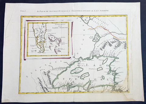
1778 Antonio Zatta & John Mitchell Antique Map of Lake Superior & Florida
Antique Map
- Title : Il Paese de Selvaggi Outauace si e Kilistinesi Intorno Al Lago Superiore; Supplemento alla Florida Orientale
- Date : 1778
- Condition: (A+) Fine Condition
- Ref: 93517
- Size: 21in x 15 1/2in (535mm x 395mm)
Description:
This wonderfully executed original copper plate engraved hand coloured antique map of Lake Superior, with an inset map of southern Florida, was published as Sheet 1, of 12, of Antonio Zattas 1778 re-issue of John Mitchells famous landmark map A Map of the British and French Dominions in North America, With the Roads, Distances, Limits, and Extent of the Settlements was published in Zattas Atlas Atlante Novissimo (1779-1785)
I have included an image of the complete 12 sheet joined map by Zatta as well as an image of Mitchells map.
General Definitions:
Paper thickness and quality: - Heavy and stable
Paper color : - off white
Age of map color: - Original
Colors used: - Yellow, green, blue, pink
General color appearance: - Authentic
Paper size: - 21in x 15 1/2in (535mm x 395mm)
Plate size: - 17 1/2in x 13 1/2in (445mm x 345mm)
Margins: - Min 1in (25mm)
Imperfections:
Margins: - None
Plate area: - None
Verso: - None
Background:
The Mitchell Map by John Mitchell (1711–1768) is considered the most famous map of North America both cartographically and historically, was reprinted several times during the second half of the 18th century. The Mitchell Map was used as a primary map source during the Treaty of Paris for defining the boundaries of the newly independent United States. The map remained important for resolving border disputes between the United States and Canada as recently as the 1980s dispute over the Gulf of Maine fisheries. The Mitchell Map is the most comprehensive map of eastern North America made during the colonial era. Its size is about 6.5 feet (2.0 m) wide by 4.5 feet (1.4 m) high.
John Mitchell was not a professional geographer or map-maker. Son of a wealthy Virginian family in Lancaster County, on Virginia's Northern Neck, he had been educated at Edinburgh University, Scotland; this education included the first two years of the three-year medical program. Returning to coastal Virginia, he practiced as a physician and studied the local botany. Ill health forced Mitchell and his wife to leave Virginia for London in 1746. There, he served as a consultant on exotic plants to noblemen interested in gardens. Also, it was there that Mitchell would make his famous map. Map historians have understandably been interested in why a physician and botanist who had shown no previous interest in map making should make such a large and detailed map.
Until recently, historians have argued that Mitchell was upset by the lack of interest shown by politicians in London about colonial affairs and so set out to warn them about the dangers posed to the British colonies by the French. Mitchell did so, on his own initiative, by making a first map of North America in 1750, which he then showed to the politicians he knew through his botanical and gardening activities. The map so impressed George Montagu-Dunk, 2nd Earl of Halifax, appointed president of the Board of Trade and Plantations in 1748, that Halifax opened up the official archives and solicited new maps from the colonies for Mitchell to make a new and better map. This was the map published in 1755. That is, the motive force for preparations against the French threat is understood to have come from a colonist who sought to take control of the colonies' future on behalf of the other colonists.
A re-examination of the archival evidence indicates, however, that Mitchell made his first map in 1750 at Halifax's behest. Halifax became president of the Board of Trade directly after the conclusion of the War of the Austrian Succession (1744–1748) and its North American component, King George's War. The war had ended in stalemate and a return to the Anglo-French status quo of the 1714 Treaty of Utrecht. In fact, it was a common conviction that it was only a matter of time before another global Anglo-French war would begin, and it was commonly expected that the spark of the new conflict would be the North American colonies. It was then that Halifax latched onto Mitchell as an expert informant on all things colonial; one of his requests, apparently, was for Mitchell to make a new map to show the territorial situation in North America. Certainly, it was only after 1749 that Mitchell's correspondence revealed his new interests in both geography and politics.
Mitchell compiled a first map in 1750 from the materials that he could find in London, in official archives and private hands. It proved to be inadequate. Halifax accordingly ordered the governors of the British colonies to send new maps, which most did. These became the basis, when fitted into the overall geographical frame provided by the maps of the French geographer Guillaume Delisle. Late in 1754, Halifax was using one manuscript copy of Mitchell's second map to successfully promote his political position (no compromise with the French) within the British cabinet in the build-up to the Seven Years' War aka French and Indian War. Halifax also permitted Mitchell to have the map published: it appeared in April 1755, engraved by Thomas Kitchin and published by Andrew Millar.
The published map bore the title A Map of the British and French Dominions in North America. It bore the copyright date of 13 February 1755, but the map was probably not sold to the public until April or even May. Minor corrections to the map's printing plates were made probably during the printing process.
The geographer John Green (né Braddock Mead) criticized Mitchell and his map soon after it appeared, emphasizing two failings with respect to Nova Scotia (an area of particular dispute with the French). Mitchell, Green noted, had used neither the astronomical observations for latitude and longitude made by Marquis Joseph Bernard de Chabert in the 1740s nor a 1715 chart of the Nova Scotia coast. In response, Mitchell released a new version of his map, now with two large blocks of text that described all of his data sources; the new version of the map also adjusted the coastline in line with Chabert's work but rejected the 1715 chart as deeply flawed. This version of the map, which Mitchell referred to as the "second edition," is commonly thought to have appeared sometime in 1757, but advertisements in the (London) Public Advertiser and Gazetteer and London Daily Advertiser on 23 April 1756 clearly indicate that this new map appeared at that time.
The map continued to be corrected and some boundaries updated, even after Mitchell's death in 1768.
Mitchell's map was printed in eight sheets; when assembled, it measures 136 cm by 195 cm (4 feet 6 inches by 6 feet 5 inches; height x width). The initial impressions printed in 1755 have a consistent coloring outlining British colonial claims. Mitchell extended the southern colonies across the entire continent, even over established Spanish territory west of the Mississippi. Mitchell divided up the Iroquois territories (as he understood them, reaching from Lake Champlain [Lac Irocoisia] to the Mississippi, and north of Lake Superior) between Virginia and New York, leaving only a much-reduced territory to the French.
Mitchell's map was expensive but it spawned many cheaper variants that trumpeted Halifax and Mitchell's powerful colonial vision to the British public. One of these, published in December 1755 by "a Society of Anti-Gallicans", restricted the French even further just to Quebec.
The map is liberally sprinkled with text describing and explaining various features, especially in regions that were relatively unknown or which were subject to political dispute. Many notes describe the natural resources and potential for settlement of frontier regions. Others describe Indian tribes. Many Indian settlements are shown, along with important Indian trails.
Since Mitchell's main objective was to show the French threat to the British colonies, there is a very strong pro-British bias in the map, especially with regard to the Iroquois. The map makes clear that the Iroquois were not just allies of Britain, but subjects, and that all Iroquois land was therefore British territory. Huge parts of the continent are noted as being British due to Iroquois conquest of one tribe or another. French activity within the Iroquois claimed lands is noted, explicitly or implicitly, as illegal.
In cases where the imperial claims of Britain and France were questionable, Mitchell always takes the British side. Thus many of his notes and boundaries seem like political propaganda today. Some of the claims seem to be outright falsehoods.
The map is very large and the notes are often very small, making it difficult to view online. Reduced scale copies result in unreadable notes. The following list gives a few examples of the kind of notes found on the map, with Mitchell's spelling:
- The region of today's central Tennessee and Kentucky (between the Tennessee and Cumberland Rivers): A Fine Level Fertile Country of great Extent, by Accounts of the Indians and our People
- In the area between the Mississippi River and the Tennessee River: This Country of the Cherokees which extends Westward to the Mississippi and Northward to the Confines of the Six Nations was formally surrendered to the Crown of Britain at Westminster 1729
- In the Great Plains: The Nadouessoians are reckoned one of the most Populous Nations of Indians in North America, altho' the number and situation of their Villages are not known nor laid down. (Reference to the Sioux)
- Along the coast of the Gulf of Mexico, present-day Texas: Wandering Savage Indians
- Southwest of Hudson Bay: The long and Barbarous Names lately given to some of these Northern Parts of Canada and the Lakes we have not inserted, as they are of no use, and uncertain Authority.
- North of Lake Huron: MESSESAGUES—Subdued by the Iroquois and now united with them making the 8th Nation in that League. (reference to the Mississaugas)
- Missouri River: Missouri River is reckoned to run Westward to the Mountains of New Mexico, as far as the Ohio does Eastward
- Present-day Iowa: Extensive Meadows full of Buffaloes
- Sandusky, Ohio: Sandoski—Canahogue—The seat of War, the Mart of Trade, & chief Hunting Grounds of the Six Nations, on the Lakes & the Ohio.
- Central Pennsylvania, north of present-day Harrisburg: St. Anthony's Wilderness
- Illinois region: The Antient Eriez were extirpated by the Iroquois upwards of 100 years ago, ever since which time they have been in Possession of L. Erie (reference to the Erie people)
- Along Illinois River and overland to the south end of Lake Michigan: Western Bounds of the Six Nations sold and Surrendered to Great Britain
- Illinois region: The Six Nations have extended their Territories to the River Illinois, ever since the Year 1672, when they subdued, and were incorporated with, the Antient Chaouanons, the Native Proprietors of these Countries, and the River Ohio. Besides which they likewise claim a Right of Conquest over the Illinois, and all the Mississippi as far as they extend. This is confirmed by their own Claims and Possessions in 1742, which include all the Bounds here laid down, and none have ever thought fit to dispute them. (reference to the Illiniwek)
- Just below the previous note: The Ohio Indians are a mixt Tribe of the Several Indians of our Colonies, settled here under the Six Nations, who have always been in Alliance and Subjection to the English. The most numerous of them are the Delaware and Shawnoes, who are Natives of Delaware River. Those about Philadelphia were called Sauwanoos whom we now call Shawanoes, or Shawnoes. The Mohickans and Minquaas were the Antient Inhabitants of Susquehanna R. (reference to the Lenape, Shawnee, and Susquehannock Indians)
- Southeast Missouri area: Mines of Marameg, which gave rise to the famous Mississippi Scheme 1719.
- North Florida: TIMOOQUA—Destroy'd by the Carolinians in 1706 (reference to the Timucua)
- South Georgia: COUNTRY OF THE APALACHEES—Conquered & surrendered to the Carolinians, after two memorable Victories obtain'd over them & the Spaniards in 1702 & 1703 at the Places marked thus [crossed-swords] (reference to the Apalachee)
- Alabama area: The English have Factories & Settlements in all the Towns of the Creek Indians of any note, except Albamas; which was usurped by the French in 1715 but established by the English 28 years before. (reference to the Creek people)
- Yazoo River: River of the Yasous—The Indians on this River were in Alliance with the English, for which they have been destroyed by the French (reference to the Yazoo tribe)
- Many geographic features are labeled with names no longer in use or oddly spelled, including:
Des Moines River: Moingona River
Kanawha and New River together: Gr. Conhaway called Wood R. or New R.
Kentucky River: Cuttawa or Catawba R.
Clinch River: Pelisipi River (a tributary is labeled Clinch's R.)
Tennessee River: River of the Cherakees, or Hogohegee R. Upstream another label says River Hogohegee or Callamaco
French Broad River: Agiqua R.
Little Tennessee River: Tannaſsee or Satico R.
Hiwassee River: Euphasee
Ohio River: Ohio or Splawacipiki R.
Altamaha River: Alatamaha or George R.
Minnesota River: Ouadebameniſsouté or R. St. Peter (reflecting the Dakota name Watpá Mnísota and the French name Rivière de St. Pierre)
Muskegon River: Maticon R.
The map also included non-existent features, such as Isle Phelipeaux in Lake Superior, found in earlier maps by Jacques-Nicolas Bellin.
The Mitchell Map remained the most detailed map of North America available in the later eighteenth century. Various impressions (and also French copies) were used to establish the boundaries of the new United States of America by diplomats at the 1783 Treaty of Paris that ended the American Revolutionary War. The map's inaccuracies subsequently led to a number of border disputes, such as in Maine. Its supposition that the Mississippi River extended north to the 50th parallel (into British territory) resulted in the treaty using it as a landmark for a geographically impossible definition of the border in that region. It was not until 1842, when the Webster-Ashburton Treaty resolved these inconsistencies with fixes such as the one that created Minnesota's Northwest Angle, that the U.S.–Canada border was clearly drawn from Maine to the Oregon Country.
Similarly, during the drafting of the Northwest Ordinance, the map's inaccuracy in depicting where an east–west line drawn through the southernmost point of Lake Michigan would intersect Lake Erie led to a long dispute over the Ohio–Michigan border that culminated in the Toledo War.


