Maps (57)
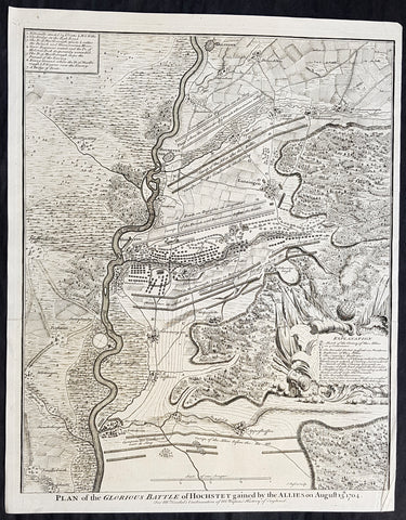
1745 Nicolas Tindal Antique Map The Battle of Blenheim, Germany in 1704
Antique Map
- Title : Plan of the Glorious Battle of Hochstet gained by the Allies on August 13.th 1704.
- Size: 21in x 17in (530mm x 430mm)
- Ref #: 22178
- Date : 1745
- Condition: (A+) Fine Condition
Description:
This original copper-plate engraved antique map, plan of the The Battle of Blenheim or Hochstadt, fought in Bavaria, Germany in August 1704 - during the Spanish War of Succession (1701-13) - was engraved by John Basire and was published in the 1745 edition of Nicholas Tindals Continuation of Mr. Rapins History of England.
General Definitions:
Paper thickness and quality: - Heavy and stable
Paper color : - off white
Age of map color: -
Colors used: -
General color appearance: -
Paper size: - 21in x 17in (530mm x 430mm)
Plate size: - 21in x 17in (530mm x 430mm)
Margins: - Min 1/2in (12mm)
Imperfections:
Margins: - None
Plate area: - Folds as issued
Verso: - None
Background:
The Battle of Blenheim (German: Zweite Schlacht bei Höchstädt; French Bataille de Höchstädt), fought on 13 August 1704, was a major battle of the War of the Spanish Succession. The overwhelming Allied victory ensured the safety of Vienna from the Franco-Bavarian army, thus preventing the collapse of the Grand Alliance.
Louis XIV of France sought to knock the Holy Roman Emperor, Leopold out of the war by seizing Vienna, the Habsburg capital, and gain a favourable peace settlement. The dangers to Vienna were considerable: the Elector of Bavaria and Marshal Marsins forces in Bavaria threatened from the west, and Marshal Vendômes large army in northern Italy posed a serious danger with a potential offensive through the Brenner Pass. Vienna was also under pressure from Rákóczis Hungarian revolt from its eastern approaches. Realising the danger, the Duke of Marlborough resolved to alleviate the peril to Vienna by marching his forces south from Bedburg to help maintain Emperor Leopold within the Grand Alliance.
A combination of deception and skilled administration – designed to conceal his true destination from friend and foe alike – enabled Marlborough to march 400 kilometres (250 miles) unhindered from the Low Countries to the River Danube in five weeks. After securing Donauwörth on the Danube, Marlborough sought to engage the Electors and Marsins army before Marshal Tallard could bring reinforcements through the Black Forest. However, with the Franco-Bavarian commanders reluctant to fight until their numbers were deemed sufficient, the Duke enacted a policy of plundering in Bavaria designed to force the issue. The tactic proved unsuccessful, but when Tallard arrived to bolster the Electors army, and Prince Eugene arrived with reinforcements for the Allies, the two armies finally met on the banks of the Danube in and around the small village of Blindheim, from which the English Blenheim is derived.
Blenheim was one of the battles that altered the course of the war, which until then was leaning for Louis coalition, and ended French plans of knocking the Emperor out of the war. France suffered as many as 38,000 casualties including the commander-in-chief, Marshal Tallard, who was taken captive to England. Before the 1704 campaign ended, the Allies had taken Landau, and the towns of Trier and Trarbach on the Moselle in preparation for the following years campaign into France itself. The offensive never materialised as the Grand Alliances army had to depart the Moselle to defend Liège from a French counteroffensive. The war would rage on for another decade.
Tindal, Nicolas 1687 – 1774
Nicolas Tindal was the translator and continuer of the History of England published by Paul de Rapin (1661-1725) in 1724. De Rapins publication chronicles the History of Britain from the invasion of the Romans to the death of Charles I. Very few comprehensive histories of England existed at the time and Tindal added his three-volume Continuation, of the Kingdom, from the reigns of James II to George II.
Tindal\\\'s translation of de Rapins History, was first published in 1727. Tindal enlarged the volumes in their second edition (1732) to contain notes, genealogical tables and maps of his own composition. In 1745 Tindal published Tindal’s Continuation of Mr. Rapin’s History of England. Included with this edition was an atlas containing 45 maps, battle and town plans from the Spanish War of Succession (1701-13) that were engraved by Richard William Seale and John Basire.
These maps represent battles that took place during the War of Spanish Succession, concluded by the Treaties of Utrecht. The war resulted from a dispute over who should inherit Spain and its possessions after its Habsburg rulers in 1700. The last Habsburg king of Spain, Charles II (d. 1700) had left the throne to his closest relative in female line: Philippe de France, duke of Anjou, grandson of Louis XIV (Felipe V of Spain). The closest relatives in male line, the Habsburgs of Austria, disputed this claim, and many European nations did not want to see French princes reigning over both kingdoms. The Utrecht treaties recognized Felipe V of Spain, but transferred the Spanish possessions in the Netherlands and Italy to Austria and to Savoy. To reach the goal of separating the crowns of France and Spain, the treaties required Felipe V to relinquish all claims to the French throne, and the remaining French princes to relinquish all claims to the Spanish throne.
The War of the Spanish Succession, was also known as Marlboroughs Wars, that was fought in Europe and the Mediterranean, and were the last and the bloodiest of the Wars between England and France under Louis XIV, and the first in which Britain played a major military role in European military affairs.
Paul de Rapin 1661-1725 was born in Castes and educated at the Protestant academy of Saumur. In 1685 after the death of his father he moved to England but after being unable to find employment moved to Holland and enlisted in French volunteers at Utrecht commanded by his cousin Daniel de Rapin. He accompanied the prince of Orange to England in 1688 and participated in the Irish campaigns of the siege of Carrickfergus, Battle of the Boyne and Limerick. Rapin resigned to become tutor to the Earl of Portlands son. He settled in Holland where he began work on The History of England. It was published in Holland in 1724 in 8 volumes. The work was an attempt to be exhaustive in the spirit of the eighteenth century philosophies by treating the subject from prehistoric times up to the date of publication.
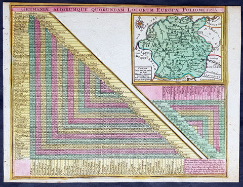
1744 Georg Mattaus Seutter Antique Map of Germany w/ European City Mileage Chart
Antique Map
- Title : Germaniae Aliorumque Quorundam Locorum Europae Poliometria....Cart von Deutsschland...Tob. Conrad Lotter Geogr.
- Ref #: 93404
- Size: 11in x 8 1/2in (280mm x 215mm)
- Date : 1744
- Condition: (A+) Fine Condition
Description:
This beautifully hand coloured original copper-plate engraved antique map of Germany, with a mileage index chart with all the major cities of Europe, was engraved by Tobias Lotter and was published in the 1744 edition of GM Seutters Atlas Minor Prae cipua Orbis Terrarum Imperia Regna et Provincias...., Augsburg, Germany.
General Definitions:
Paper thickness and quality: - Heavy and stable
Paper color : - off white
Age of map color: - Original
Colors used: - Yellow, green, blue, pink
General color appearance: - Authentic
Paper size: - 11in x 8 1/2in (280mm x 215mm)
Plate size: - 10 1/2in x 8in (265mm x 205mm)
Margins: - Min 1/4in (5mm)
Imperfections:
Margins: - Light age toning
Plate area: - Light age toning
Verso: - None
Background:
Atlas Minor was a series of beautiful maps of all parts of the world. Georg Matthäus Seutter was one of the most and important of the German cartographers of the 18th century, being appointed as the Geographer to the Imperial Court. His son, Albrecht Carl, joined Matthäus and eventually inherited the business. The maps from Atlas Minor were drawn by the two Seutters and engraved by Tobias Conrad Lotte. These maps are highly detailed and engraved with a bold hand with equally strong original hand color in the body of the map as was the 18th century German style. The cartouches were left uncolored in order to emphasize the elaborately detailed illustrations for which German maps are especially prized. These are some of the most decorative and interesting maps of the eighteenth century.
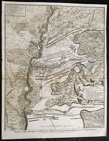
1745 Nicolas Tindal Antique Map The Battle of Blenheim, Germany in 1704
Antique Map
- Title : Plan of the Glorious Battle of Hochstet gained by the Allies on August 13.th 1704.
- Size: 21in x 17in (530mm x 430mm)
- Ref #: 15692-1
- Date : 1745
- Condition: (A+) Fine Condition
Description:
This original copper-plate engraved antique map, plan of the The Battle of Blenheim or Hochstadt, fought in Bavaria, Germany in August 1704 - during the Spanish War of Succession (1701-13) - was engraved by John Basire and was published in the 1745 edition of Nicholas Tindals Continuation of Mr. Rapins History of England.
General Definitions:
Paper thickness and quality: - Heavy and stable
Paper color : - off white
Age of map color: -
Colors used: -
General color appearance: -
Paper size: - 21in x 17in (530mm x 430mm)
Plate size: - 21in x 17in (530mm x 430mm)
Margins: - Min 1/2in (12mm)
Imperfections:
Margins: - None
Plate area: - Folds as issued
Verso: - None
Background:
The Battle of Blenheim (German: Zweite Schlacht bei Höchstädt; French Bataille de Höchstädt), fought on 13 August 1704, was a major battle of the War of the Spanish Succession. The overwhelming Allied victory ensured the safety of Vienna from the Franco-Bavarian army, thus preventing the collapse of the Grand Alliance.
Louis XIV of France sought to knock the Holy Roman Emperor, Leopold out of the war by seizing Vienna, the Habsburg capital, and gain a favourable peace settlement. The dangers to Vienna were considerable: the Elector of Bavaria and Marshal Marsins forces in Bavaria threatened from the west, and Marshal Vendômes large army in northern Italy posed a serious danger with a potential offensive through the Brenner Pass. Vienna was also under pressure from Rákóczis Hungarian revolt from its eastern approaches. Realising the danger, the Duke of Marlborough resolved to alleviate the peril to Vienna by marching his forces south from Bedburg to help maintain Emperor Leopold within the Grand Alliance.
A combination of deception and skilled administration – designed to conceal his true destination from friend and foe alike – enabled Marlborough to march 400 kilometres (250 miles) unhindered from the Low Countries to the River Danube in five weeks. After securing Donauwörth on the Danube, Marlborough sought to engage the Electors and Marsins army before Marshal Tallard could bring reinforcements through the Black Forest. However, with the Franco-Bavarian commanders reluctant to fight until their numbers were deemed sufficient, the Duke enacted a policy of plundering in Bavaria designed to force the issue. The tactic proved unsuccessful, but when Tallard arrived to bolster the Electors army, and Prince Eugene arrived with reinforcements for the Allies, the two armies finally met on the banks of the Danube in and around the small village of Blindheim, from which the English Blenheim is derived.
Blenheim was one of the battles that altered the course of the war, which until then was leaning for Louis coalition, and ended French plans of knocking the Emperor out of the war. France suffered as many as 38,000 casualties including the commander-in-chief, Marshal Tallard, who was taken captive to England. Before the 1704 campaign ended, the Allies had taken Landau, and the towns of Trier and Trarbach on the Moselle in preparation for the following years campaign into France itself. The offensive never materialised as the Grand Alliances army had to depart the Moselle to defend Liège from a French counteroffensive. The war would rage on for another decade.
Tindal, Nicolas 1687 – 1774
Nicolas Tindal was the translator and continuer of the History of England published by Paul de Rapin (1661-1725) in 1724. De Rapins publication chronicles the History of Britain from the invasion of the Romans to the death of Charles I. Very few comprehensive histories of England existed at the time and Tindal added his three-volume Continuation, of the Kingdom, from the reigns of James II to George II.
Tindal\\\'s translation of de Rapins History, was first published in 1727. Tindal enlarged the volumes in their second edition (1732) to contain notes, genealogical tables and maps of his own composition. In 1745 Tindal published Tindal’s Continuation of Mr. Rapin’s History of England. Included with this edition was an atlas containing 45 maps, battle and town plans from the Spanish War of Succession (1701-13) that were engraved by Richard William Seale and John Basire.
These maps represent battles that took place during the War of Spanish Succession, concluded by the Treaties of Utrecht. The war resulted from a dispute over who should inherit Spain and its possessions after its Habsburg rulers in 1700. The last Habsburg king of Spain, Charles II (d. 1700) had left the throne to his closest relative in female line: Philippe de France, duke of Anjou, grandson of Louis XIV (Felipe V of Spain). The closest relatives in male line, the Habsburgs of Austria, disputed this claim, and many European nations did not want to see French princes reigning over both kingdoms. The Utrecht treaties recognized Felipe V of Spain, but transferred the Spanish possessions in the Netherlands and Italy to Austria and to Savoy. To reach the goal of separating the crowns of France and Spain, the treaties required Felipe V to relinquish all claims to the French throne, and the remaining French princes to relinquish all claims to the Spanish throne.
The War of the Spanish Succession, was also known as Marlboroughs Wars, that was fought in Europe and the Mediterranean, and were the last and the bloodiest of the Wars between England and France under Louis XIV, and the first in which Britain played a major military role in European military affairs.
Paul de Rapin 1661-1725 was born in Castes and educated at the Protestant academy of Saumur. In 1685 after the death of his father he moved to England but after being unable to find employment moved to Holland and enlisted in French volunteers at Utrecht commanded by his cousin Daniel de Rapin. He accompanied the prince of Orange to England in 1688 and participated in the Irish campaigns of the siege of Carrickfergus, Battle of the Boyne and Limerick. Rapin resigned to become tutor to the Earl of Portlands son. He settled in Holland where he began work on The History of England. It was published in Holland in 1724 in 8 volumes. The work was an attempt to be exhaustive in the spirit of the eighteenth century philosophies by treating the subject from prehistoric times up to the date of publication.
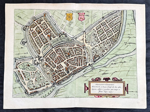
1574 Braun & Hogenberg Antique Map View of Wesel North Rhine-Westphalia, Germany
- Title : Hermannus Hammelman Wesalia in Ducatu Cliuensi
- Size: 21in x 16in (545mm x 410mm)
- Condition: (A+) Fine Condition
- Date : 1574
- Ref #: 81068-1
Description:
This original copper-plate engraved hnd coloured antique map, plan, a birds eye view of city of Wesel in North Rhine-Westphalia, Germany was published by Georg Braun & Frans Hogenberg for the 1574 atlas of town plans Civiates Orbis Terrarum intended as a companion to Abraham Ortelius master Atlas Theatrum Orbis Terrarum published in 1570.
General Definitions:
Paper thickness and quality: - Heavy and stable
Paper color : - off white
Age of map color: - Later
Colors used: - Green, pink, blue, yellow
General color appearance: - Authentic
Paper size: - 21in x 16in (545mm x 410mm)
Plate size: - 19in x 13 1/2in (480mm x 340mm)
Margins: - Min 1in (25mm)
Imperfections:
Margins: - None
Plate area: - None
Verso: - None
Background:
Wesel is a city in North Rhine-Westphalia, Germany. It is the capital of the Wesel district.
The city originated from a Franconian manor that was first recorded in the 8th century. In the 12th century, the Duke of Clèves took possession of Wesel. The city became a member of the Hanseatic League during the 15th century. Wesel was second only to Cologne in the lower Rhine region as an entrepôt. It was an important commercial centre: a clearing station for the trans-shipment and trading of goods.
In 1590 the Spanish captured Wesel after a four-year siege. The city changed hands between the Dutch and Spanish several times during the Eighty Years War. In 1672 a French force under Louis II de Bourbon, Prince de Condé captured the city. Wesel was inherited by the Hohenzollerns of the Margraviate of Brandenburg in 1609 but they were unable to take control of Wesel until the Treaty of Nijmegen in 1678. Although the city had been heavily fortified the Prussians evacuated the city during the Seven Years War and it was occupied by the French. It was returned to Prussia at the end of the war. Friedrich Wilhelm von Dossow was the Prussian Governor of Wesel during the 18th century. Wesel was ceded to the French in 1805 under the treaty of Schönbrunn. The French heavily fortified the city constructing a rectangular fort called the Citadelle Napoleon at Büderich and the Citadelle Bonaparte on an island in the Rhine off Wesel. Though blockaded by the Allies in 1813 the city remained in French hands until after the Battle of Waterloo. After the Napoleonic Wars of the early 19th century, the city became part of the Prussian Rhine Province and the Citadelle Napoleon was renamed Fort Blücher.
1628 Gerard Mercator & Henricus Hondius Antique Map of Duchy Wurttemberg Germany
- Title : Wirtenberg Ducatus...Per Geradum Mercatorem Cum Privilego
- Size: 21in x 17in (530mm x 430mm)
- Condition: (A+) Fine Condition
- Date : 1628
- Ref #: 26116
Description:
This original copper plate engraved hand coloured antique map of the Wurttemberg region in todays Baden-Württemberg state in southern Germany, by Gerard Mercator was published by Henricus Hondius in the early 1628 French edition of Gerard Mercators Atlas.
These maps, published in the early editions of Mercators atlas, are the original maps drawn and engraved by Gerald Mercator in the mid to late 16th century, published by his son Rumold as an atlas, after his death, in 1595. After two editions the plates were purchased by Jodocus Hondius in 1604 and continued to be published until the mid 1630\'s when the plates were re-engraved and updated by Jan Jansson and Henricus Hondius.
General Definitions:
Paper thickness and quality: - Heavy and stable
Paper color : - off white
Age of map color: - Later
Colors used: - Green, yellow, brown, blue, pink
General color appearance: - Authentic
Paper size: - 21in x 17in (530mm x 430mm)
Plate size: - 18 1/2in x 14in (475mm x 350mm)
Margins: - Min 1/2in (12mm)
Imperfections:
Margins: - Light age toning
Plate area: - Light toning along centerfold
Verso: - Light age toning
Background:
Württemberg is a historical German territory roughly corresponding to the cultural and linguistic region of Swabia. Together with Baden and Hohenzollern, two other historical territories, it now forms the Federal State of Baden-Württemberg. Württemberg was formerly also spelled Würtemberg and Wirtemberg.
The Duchy of Württemberg was a duchy located in the south-western part of the Holy Roman Empire. It was a member of the Holy Roman Empire from 1495 to 1806. The dukedoms long survival for nearly four centuries was mainly due to its size, being larger than its immediate neighbors. During the Protestant Reformation, Württemberg faced great pressure from the Holy Roman Empire to remain a member. Württemberg resisted repeated French invasions in the 17th and 18th centuries. Württemberg was directly in the path of French and Austrian armies who were engaged in the long rivalry between the House of Bourbon and the House of Habsburg. In 1803, Napoleon raised the duchy to be the Electorate of Württemberg of the Holy Roman Empire. On 1 January 1806, the last Elector assumed the title of King of Württemberg. Later this year, on 6 August 1806, the last Emperor, Francis II, abolished (de facto) the Holy Roman Empire.
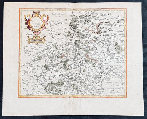
1628 Gerard Mercator & Henricus Hondius Antique Map State of Hesse, Germany
- Title : Hassia landtgrauiatus...Per Geradum Mercatorem Cum Privilego
- Size: 21in x 17in (530mm x 430mm)
- Condition: (A) Very Good Condition
- Date : 1628
- Ref #: 26107
Description:
This original copper plate engraved hand coloured antique map of the State of Hesse or Hessia, in central Germany, by Gerard Mercator was published by Henricus Hondius in the early 1628 French edition of Gerard Mercators Atlas.
These maps, published in the early editions of Mercators atlas, are the original maps drawn and engraved by Gerald Mercator in the mid to late 16th century, published by his son Rumold as an atlas, after his death, in 1595. After two editions the plates were purchased by Jodocus Hondius in 1604 and continued to be published until the mid 1630s by Henricus, when some of the plates were re-engraved and updated by Jan Jansson and Henricus Hondius.
General Definitions:
Paper thickness and quality: - Heavy and stable
Paper color : - off white
Age of map color: - Later
Colors used: - Green, yellow, brown, blue, pink
General color appearance: - Authentic
Paper size: - 21in x 17in (530mm x 430mm)
Plate size: - 18 1/2in x 14in (475mm x 350mm)
Margins: - Min 1/2in (12mm)
Imperfections:
Margins: - Light age toning
Plate area: - Light toning along centerfold
Verso: - Light age toning
Background:
Hesse officially the State of Hesse, is a federal state (Land) of the Federal Republic of Germany, with just over six million inhabitants. The state capital is Wiesbaden; the largest city is Frankfurt am Main.
In the 12th century, Hessengau was passed to Thuringia. In the War of the Thuringian Succession (1247–1264), Hesse gained independence and became a Landgraviate within the Holy Roman Empire. It shortly rose to primary importance under Landgrave Philip the Magnanimous, who was one of the leaders of German Protestantism. After Philips death in 1567, the territory was divided among his four sons from his first marriage (Philip was a bigamist) into four lines: Hesse-Kassel (or Hesse-Cassel), Hesse-Darmstadt, Hesse-Rheinfels, and the also previously existing Hesse-Marburg. As the latter two lines died out quite soon (1583 and 1605, respectively), Hesse-Kassel and Hesse-Darmstadt were the two core states within the Hessian lands. Several collateral lines split off during the centuries, such as in 1622, when Hesse-Homburg split off from Hesse-Darmstadt. In the late 16th century, Kassel adopted Calvinism, while Darmstadt remained Lutheran and subsequently the two lines often found themselves on different sides of a conflict, most notably in the disputes over Hesse-Marburg and in the Thirty Years War, when Darmstadt fought on the side of the Emperor, while Kassel sided with Sweden and France.
The Landgrave Frederick II (1720–1785) ruled as a benevolent despot, from 1760 to 1785. He combined Enlightenment ideas with Christian values, cameralist plans for central control of the economy, and a militaristic approach toward diplomacy.[16] He funded the depleted treasury of the poor nation by loaning 19,000 soldiers in complete military formations to Great Britain to fight in North America during the American Revolutionary War, 1776–1783. These soldiers, commonly known as Hessians, fought under the British flag. The British used the Hessians in several conflicts, including in the Irish Rebellion of 1798. For further revenue, the soldiers were loaned to other places as well. Most were conscripted, with their pay going to the Landgrave.
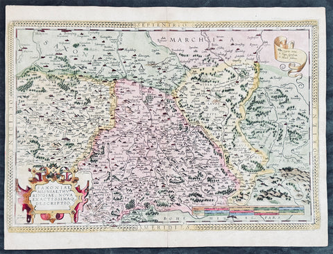
1575 Abraham Ortelius Antique Map of Saxony Eastern Germany & Western Poland
- Title : Saxoniae Misniae, Thuringiae, Nova Exactissimaq Descriptio
- Size: 20 1/2in x 15 1/2in (520mm x 390mm)
- Condition: (A+) Fine Condition
- Date : 1587
- Ref #: 30032
Description:
These original copper-plate engraved hand coloured antique map of the Saxony region of Germany, historically covering eastern Germany and Western Poland and Silesia (today Obersachsen, Meissen and Thuringen regions) was published in the 1575 French edition of Abraham Ortelius Atlas Theatrum Orbis Terrarum.
General Definitions:
Paper thickness and quality: - Heavy and stable
Paper color : - off white
Age of map color: - Later
Colors used: - Green, yellow, pink, blue
General color appearance: - Authentic
Paper size: - 20 1/2in x 15 1/2in (520mm x 390mm)
Plate size: - 20in x 13 1/2in (510mm x 345mm)
Margins: - Min 1/4in (4mm)
Imperfections:
Margins: - Light soiling
Plate area: - None
Verso: - Soiling
Background:
Ortelius regional map of Germany, showing the area between Berlin and Braunschweig in the north, to Prague in the south and Silesia in the east. With Chemnitz, Dresden, Leipzig, Wittenberg and Erfurt
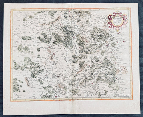
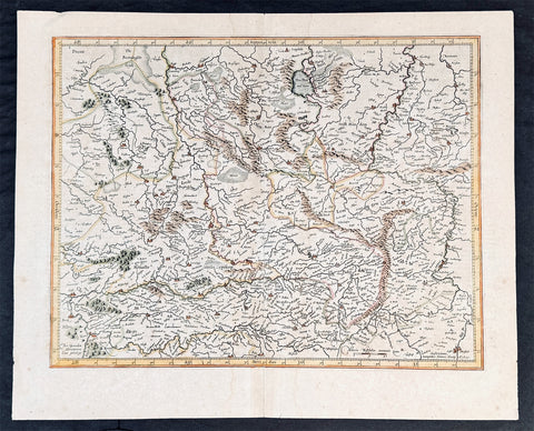
1628 Gerard Mercator Antique Map Lotharingia Region - Netherlands Germany France
Antique Map
- Title : Lotharingia Ducatus...Per Geradum Mercatorem Cum Privilegio
- Size: 21in x 17in (530mm x 430mm)
- Condition: (A) Very Good Condition
- Date : 1628
- Ref #: 26141
Description:
This original copper plate engraved hand coloured antique map of the historical region of Lotharingia region of present-day Netherlands, Belgium, Luxembourg, North Rhine-Westphalia (Germany), Rhineland-Palatinate (Germany), Saarland (Germany), and Lorraine (France) by Gerard Mercator was published by Henricus Hondius in the early 1628 French edition of Gerard Mercators Atlas.
These maps, published in the early editions of Mercators atlas, are the original maps drawn and engraved by Gerald Mercator in the mid to late 16th century, published by his son Rumold as an atlas, after his death, in 1595. After two editions the plates were purchased by Jodocus Hondius in 1604 and continued to be published until the mid 1630\\\'s when the plates were re-engraved and updated by Jan Jansson and Henricus Hondius.
General Definitions:
Paper thickness and quality: - Heavy and stable
Paper color : - off white
Age of map color: - Later
Colors used: - Green, yellow, pink, brown
General color appearance: - Authentic
Paper size: - 21in x 17in (530mm x 430mm)
Plate size: - 20in x 15in (510mm x 380mm)
Margins: - Min 1/2in (12mm)
Imperfections:
Margins: - Age toning
Plate area: - Age toning, light creasing
Verso: - Age toning
Background:
Lotharingia was a medieval successor kingdom of the Carolingian Empire, comprising the present-day Netherlands, Belgium, Luxembourg, North Rhine-Westphalia (Germany), Rhineland-Palatinate (Germany), Saarland (Germany), and Lorraine (France). It was named after King Lothair II who received this territory after the kingdom of Middle Francia of his father Lothair I was divided among his sons in 855.
Lotharingia was born out of the tripartite division in 855 of the kingdom of Middle Francia, which itself was formed after the threefold division of the Carolingian Empire by the Treaty of Verdun of 843. Conflict between East and West Francia over Lotharingia was based on the fact that these were the old Frankish homelands of Austrasia, so possession of them was of great prestige.
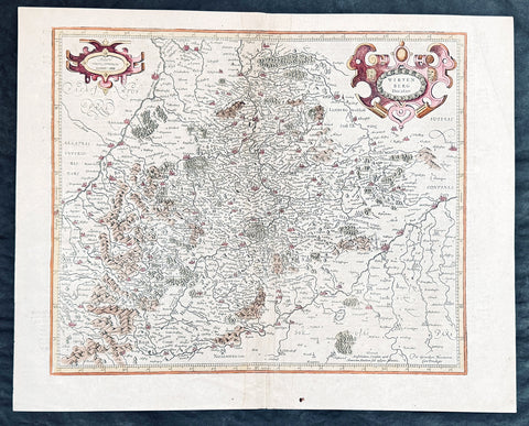
1628 Gerard Mercator & Henricus Hondius Antique Map of Westphalia, Germany
- Title : Tabula Seconde Westphalia...Per Geradum Mercatorem Cum Privilego...1627
- Size: 21in x 17in (530mm x 430mm)
- Condition: (A) Very Good Condition
- Date : 1628
- Ref #: 26109
Description:
This original copper plate engraved hand coloured antique map of the Westphalia region of North Rhine-Westphalia, Germany, by Gerard Mercator was published by Henricus Hondius in the early 1628 French edition of Gerard Mercators Atlas.
These maps, published in the early editions of Mercators atlas, are the original maps drawn and engraved by Gerald Mercator in the mid to late 16th century, published by his son Rumold as an atlas, after his death, in 1595. After two editions the plates were purchased by Jodocus Hondius in 1604 and continued to be published until the mid 1630s by Henricus, when some of the plates were re-engraved and updated by Jan Jansson and Henricus Hondius.
General Definitions:
Paper thickness and quality: - Heavy and stable
Paper color : - off white
Age of map color: - Later
Colors used: - Green, blue, pink, yellow
General color appearance: - Authentic
Paper size: - 21in x 17in (530mm x 430mm)
Plate size: - 18 1/2in x 14in (475mm x 350mm)
Margins: - Min 1/2in (12mm)
Imperfections:
Margins: - Light age toning
Plate area: - Light toning along centerfold
Verso: - Light age toning
Background:
While the Northern Rhineland, Westphalia and Lippe are different historic territories of todays North Rhine-Westphalia, the old border between the former Rhine Province and the Province of Westphalia is also a language border. While in Westphalia and Lippe, people tend to speak West Low German dialects and especially the Westphalian variant of the Low German language, Central German and Low Franconian dialects are being spoken in the Northern Rhineland.
Westphalia is known for the 1648 Peace of Westphalia which ended the Thirty Years War, as the two treaties were signed in Münster and Osnabrück.
It is one of the regions that were part of all incarnations of the German state since the Early Middle Ages: the Holy Roman Empire, the Confederation of the Rhine, the German Confederation, the North German Confederation, the German Empire, the Weimar Republic and National Socialist Germany. After World War II it was a part of the British occupation zone which merged with the American zone to become the Bizone in 1947 and again merged with the French zone to become the Trizone in 1948. The current Federal Republic of Germany was founded on these territories making Westphalia a part of West Germany. It is a part of united Germany since 1990.