
Background :
John Speed is arguably the most famous cartographer of any period, as a result of his atlas The Theatre of the Empire of Great Britaine, the first atlas of the British Isles. The individual maps are the best known and among the most sought-after of all county maps. The maps themselves were derived from the best and most up-to-date sources available; however, Speed did make innovations- introducing town plans on many of his maps, he included county boundaries on almost all maps, also the coats of arms of local Earls and Dukes and the Royal arms. The overall effect is to produce very decorative, attractive and informative maps.
Speed also produced the first world atlas by an Englishman, entitled The Prospect of the most Famous Parts of the World (1627). The maps are famous for their bordering panels of national characters in local costume and panoramic views depicting the areas major towns and cities. In addition to the obvious decorative quality of the maps, regular atlas copies have two pages of English text printed on the reverse, giving a charming description of life in the early seventeenth century of the area shown
John Speed (3)
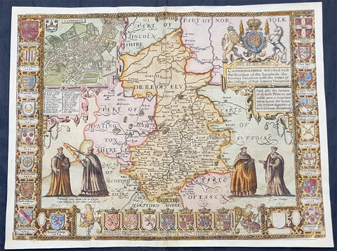
1610 John Speed Antique Map of The English County of Cambridgeshire
- Title : Cambridgeshire described with the deuision of the hundreds, the Townes situation with the Armes of the Colleges of that famous Vniuersiti...And also the Armes of all such Princes and noble men as have heertofore borne the Honorable tytles & dignities of the Earldome of Cambridge....Performed by John Speede and are to be sold in popes alley by John Sudbury and G Humbell...Cum Privilego 1610.
- Size: 20 1/2in x 15in (510mm x 380mm)
- Condition: (B) Good Condition
- Date : 1610
- Ref #: 80002
Description:
This original hand coloured antique 1st edition map of the English county of Cambridgeshire was engraved in 1610 - dated -and was published by John Sudbury & George Humble in the 1612 1st edition of John Speeds famous atlas The Theatre of the Empire of Great Britaine.
The map has some loss mainly along the borders and a few small areas below both sets of figures. Map has been mounted onto an original index page fro m Speeds atlas.
General Definitions:
Paper thickness and quality: - Heavy and stable
Paper color : - off white
Age of map color: - Original
Colors used: - Yellow, green, blue, pink
General color appearance: - Authentic
Paper size: - 20 1/2in x 15in (510mm x 380mm)
Plate size: - 20 1/2in x 15in (510mm x 380mm)
Margins: - Min 1/2in (12mm)
Imperfections:
Margins: - Map cropped to and into borders
Plate area: - Small loss below both sets of figures at the bottom of the map
Verso: - Backed onto original Speed index double page
Background:
Strong reference is made to Cambridges famous and renowned university with the (twenty five) armourials of the colleges and four scholarly figures. The birds eye view plan of Cambridge city is based on the one done by John Hammond in 1592.

1611 John Speed 1st Edition Map of Great Britain & Ireland - London & Edinbugh
- Title : The Kingdome of Great Britaine and Ireland....Graven by J Hondius and are to be solde by J Sudbury and George Humble in Pope Heads Alley in London cum privilage Regis 1610
- Ref #: 93433
- Size: 21in x 15 3/4in (535mm x 400mm)
- Date : 1611
- Condition: (A) Very Good Condition
Description:
This magnificent, beautifully hand coloured, original copper-plate engraved antique map (a true rare 1st edition - Shirley 316, catch word wee on verso) by John Speed, was engraved by the famous cartographer Jodocus Hondius and published by Sudbury & Humble in Speeds 1611-12 edition of his atlas Theatre of the Empire of Great Britaine.
A beautiful example of the first state of one the most visually striking maps ever produced of the British Isles, embellished with finely detailed views of both London and Edinburgh. The strong printing impression of this example highlights the exquisite engraving of this map, particularly the delicate detail of the two inset views.
General Definitions:
Paper thickness and quality: - Heavy and stable
Paper color : - off white
Age of map color: - Original
Colors used: - Yellow, green, blue, pink
General color appearance: - Authentic
Paper size: - 21 1/2in x 17in (545mm x 435mm)
Plate size: - 18 1/2in x 14in (470mm x 355mm)
Margins: - Min 1/2in (12mm)
Imperfections:
Margins: - All margins professionally restored from printed borders
Plate area: - Small repair to bottom centerfold
Verso: - Centerfold re-enforced.
Background:
John Speed spent 15 years gathering materials for his atlas of the British Isles, in which this map was the first to appear. Moreover, Speed went to considerable lengths to secure a top engraving talent—a fascinating story in itself--to produce this and many of the other maps in this atlas. Speed sent the visual, raw materials for his maps—drafts of the map themselves and design sketches--to Amsterdam to be engraved by Jodocus Hondius, who at the time was one of the most prominent and successful map publishers in all of Europe. Hondius, however, was well known to English map publishers, as he had worked as an engraver for hire in London in the 1580’s, where he had fled due to religious persecution in his homeland. Still, it is surprising that Speed was able to secure the services of Hondius at the height of his career, and, in fact, Hondius died shortly after completing this project. Hondius’ distinctive style can be seen in this map in its stippled seas and in its decorative detail that is rich without being disorganized or distracting.
The map itself of England was based on that of Saxton, who produced some years earlier the very first atlas of Great Britain. Ireland and Scotland were based on maps by Hondius and Mercator, respectively. The view of London was modeled after a c. 1600 drawing by C. J. Visscher, which was not published until 1616. The Edinburgh view is an adaptation of an earlier manuscript showing the city under siege in 1544.
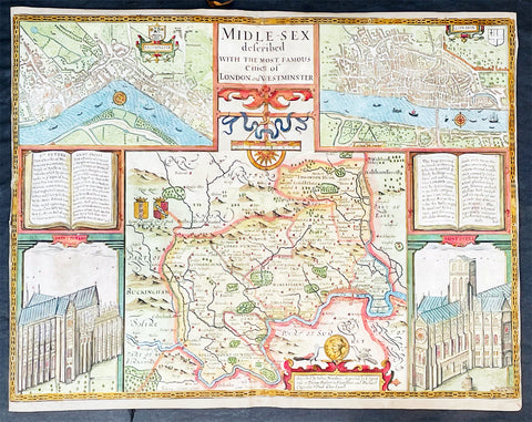
1676 John Speed Antique Map of County of Midlesex Views London & Westminster
- Title : Midle-sex Described with the most Famous Cities of London and Westminster
- Date : 1676
- Size: 20 1/4in x 16 3/4in (515mm x 425mm)
- Condition: (B) Good Condition
- Ref: 35613
Description:
This original hand coloured copper plate engraved antique map & views of London and the English county of Middlesex by John Speed was published in the 1676 Bassett & Chiswell edition of Speeds famous atlas The Theatre of the Empire of Great Britaine.
The map is embellished with the famous birds-eye views of London, Westminster and the churches of St Peters (Westminster Abbey) and old St Pauls before the great fire of London in 1666. English descriptive text of London on the verso.
General Definitions:
Paper thickness and quality: - Heavy and stable
Paper color : - off white
Age of map color: - Original
Colors used: - Blue, yellow, green, pink
General color appearance: - Authentic
Paper size: - 20 1/4in x 16 3/4in (515mm x 425mm)
Plate size: - 20 1/4in x 15 1/2in (515mm x 410mm)
Margins: - Min 1/8in (2mm)
Imperfections:
Margins: - L&R margins cropped to plate-marks
Plate area: - Re-enforced along centerfold very small loss in places, light creasing
Verso: - Re-enforced along centerfold and in several places with transparent archival tape
Background:
This county map of Middlesex, now greater London, illustrates the market towns of Enfield, Pancras, Osterley and Staines. The map is dominated by four large vignettes with the environs of London and the county situated in the central portion of the map. The actual cartography is based on the surveys performed by John Norden, the earlier English antiquary and map maker, who unsuccessfully attempted to publish an updated county atlas of the United Kingdom before Speed. Norden also lived most of his life in Middlesex, thus becoming an obvious source for the map.
The City of London is clearly shown on the lower right of the map with villages such as Hamsted, Pancras, Kensington and Paddington marked around the city. To the lower centre of the map is an acknowledgement to the original survey by Norden, augmented by Speed himself.
Although the cartography is of some note, it is the vignettes for which this map is justly famous. To the two bottom corners are the famous Churchs of St. Peter (Westminster Abbey) Westminster on the left and St. Pauls to the right. This is the medieval Cathedral of St. Pauls, just after it had lost its spire in 1561 and before the Great Fire of 1666, in which it was destroyed then rebuilt in its present form by Sir Christopher Wren. Above these two church vignettes are two text panels in the form of books, the one on the left describing the two churches and the other on the right with a description of London itself.
Finally, two large vignettes on the upper left and right corners depict the two cities of Westminster and London respectively. It is believed that Speed was not responsible for either of these images, more likely drawing from Norden, although there are no surviving evidence of this, to date yet to be found. There are also theories that these two views may have come from either a German sources or other lost birds-eye views of London by unknown persons.
Due to modern growth of London and border changes, the county of Middlesex no longer exists, but there is little doubt this is the most the best map of London and Middlesex published in the 17th century. English text on verso