
Joducus Hondius (1563 - 1612) Henricus Hondius, (1587 - 1638)
Joducus Hondius - son (1594 - 1629)
Jodocus Hondius, one of the most notable engravers of his time, is known for his work in association with many of the cartographers and publishers prominent at the end of the sixteenth and the beginning of the seventeenth century.
A native of Flanders, he grew up in Ghent, apprenticed as an instrument and globe maker and map engraver. In 1584, to escape the religious troubles sweeping the Low Countries at that time, he fled to London where he spent some years before finally settling in Amsterdam about 1593. In the London period he came into contact with the leading scientists and geographers of the day and engraved maps in The Mariner's Mirrour, the English edition of Waghenaer's Sea Atlas, as well as others with Pieter van den Keere, his brother-in-law. No doubt his temporary exile in London stood him in good stead, earning him an international reputation, for it could have been no accident that Speed chose Hondius to engrave the plates for the maps in The Theatre of the Empire of Great Britaine in the years between 1605 and 1610.
In 1604 Hondius bought the plates of Mercator's Atlas which, in spite of its excellence, had not competed successfully with the continuing demand for the Ortelius Theatrum Orbis Terrarum. To meet this competition Hondius added about 40 maps to Mercator's original number and from 16o6 published enlarged editions in many languages, still under Mercator's name but with his own name as publisher. These atlases have become known as the Mercator/Hondius series. The following year the maps were re-engraved in miniature form and issued as a pocket Atlas Minor. After the death of Jodocus Hondius the Elder in 1611, work on the two atlases, folio and miniature, was carried on by his widow and sons, Jodocus II and Henricus, and eventually in conjunction with Jan Jansson in Amsterdam. In all, from 1606 onwards, nearly 50 editions with increasing numbers of maps with texts in the main European languages were printed.
Joducus & Henricus Hondius (3)
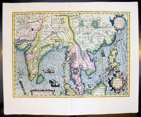
1609 Henricus Hondius Antique Map of India, China & SE Asia
- Title : India Orientalis
- Size: 22in x 18 1/2in (560mm x 470mm)
- Condition: (A+) Fine Condition
- Date : 1609
- Ref #: 75001
Description:
This beautifully engraved hand coloured original map of India, SE Asia & the East Indies was published in Gerard Mercator's French edition of Atlas sive Cosmographicae published by Henricus Hondius and Jan Jansson in 1609..
Background: One of the finest of the early Dutch maps of the region published. It was first published in 1606 as one of the 37 new maps engraved by Jodocus Hondius' for Mercators Atlas.
The map extends from India to the coasts of Southern China including the Pearl Jodocus HondiusRiver Estuary, Canton and Formosa. It also includes all of the Malay peninsula and Indochina, northern Borneo and the Philippines.
Hondius shared the classic view of the SE Asian River Systems, mapping five rivers from the Mekong westward, as originating in a lake in the Himalayas. The kingdom of Lan Na is shown originating in what is today northern Thailand and a depiction of the Mergui Archipelago off the Burmese portion of the Malay Peninsula as an island studded sea. The old capital of Siam, Ayuthaya, is shown on an island in the Gulf of Siam.
The decorative detail includes a large sea monster and an oriental junk in the Bay of Bengal as well as fine scrollwork title & scale cartouches. One of the most interesting & unusual features of the Southern Malay peninsula is its dissection in two, the southern part becoming an island just south of Malacca where it is separated from the rest of the peninsula by a large north-easterly channel. (Ref: Koeman; M&B; Tooley)
General Description:
Paper thickness and quality: - Heavy and stable
Paper color: - off white
Age of map color: - Early
Colors used: - Yellow, green, red, brown.
General color appearance: - Authentic and fresh
Paper size: - 22in x 18 1/2in (560mm x 470mm)
Plate size: - 19 1/4in x 14in (490mm x 355mm)
Margins: - Min 1in (25mm)
Imperfections:
Margins: - None
Plate area: - None
Verso: - None
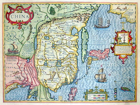
1636 Jan Jansson Antique Map of China, with Korea, Japan & Part of America
- Title : China
- Size: 23in x 19in (585mm x 480mm)
- Condition: (A+) Fine Condition
- Date : 1636
- Ref #: 75010
Description:
This map of China, Japan with Korea and parts of the west coast of America was the first Chinese map published by Mercator first released in 1606. This map was published in the 1636 edition of Mercator's Atlas published by Henricus Hondius & Jan Jansson.
General Description:
Paper thickness and quality: - Heavy and stable
Paper color: - off white
Age of map color: - Early
Colors used: - Green, red, orange, yellow, blue
General color appearance: - Authentic and beautiful
Paper size: - 23in x 19in (585mm x 480mm)
Plate size: - 18 1/2in x 14in (470mm x 355mm)
Margins: - Min 1in (25mm)
Imperfections:
Margins: - Small repair to top margin centerfold, no loss
Plate area: - None
Verso: - None
Background: This boldly engraved and hand coloured map combines elements of the maps complied by the two Portuguese Jesuits priests, on Japan by Luis Teixeira (1595) and on China by Luis Jorge de Barbuda (1584). Amoungst the decorative features including sea monsters, ships both European and Chinese and a wind powered land cart is also a vignette depicting the torture of Christians in Japan if caught.
Although Mercator has faithfully followed the Ortelius/Teixeira type of map he has added an explanation for Korea saying it was not yet certain whether it was an island or part of the mainland.
In contrast to the relatively late mapping of the major continents by the Europeans the mapping of China stretches back as far back as 1100BC. Almost 100years after Ptolemy produced "Geographia" and around the same time paper was invented in China an 18-sheet map of China was produced by Pei Hsui (AD 224-71). In the following years contact was re-established between the Chinese and Europeans - contact was known between the two cultures from before Ptolemy - through Marco Polo, Carpini (1245), Rubruquis (1252) and other Franciscan missionaries and it was through the accounts of their travels that scholars began to reshape their ideas of Cathay. In the 16th & 17th centuries the Jesuits exerted a considerable influence on Chinese mapmaking. Matteo Ricci complied the first European map of the world printed and circulated in China (1584 - 1602) Ludovico Georgio who's map of China was used by Ortelius (1584) and subsequently by other Dutch publishers; Father Martino Martini an Italian Jesuit who compiled the first European Atlas of China Atlas Sinensis which was used by Blaeu, Jansson and others. (Ref: Koeman; M&B; Tooley)
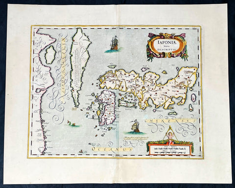
1652 Jansson Antique Map of Japan - Korea as an Island, China - Beautiful
Antique Map
- Title : Japonia nova Descriptio
- Date : 1652
- Size: 22 1/2in x 18in (570mm x 455mm)
- Condition: (A+) Fine Condition
- Ref: 35644
Description:
This fine, beautifully hand coloured original antique, early scarce map of Japan & Korea (as an Island) with parts of eastern China was published in the 1639 French edition of Gerardi Mercators Atlantis Novi Atlas by Jan Jansson and Henricus Hondius.
A beautiful map with sturdy, clean paper original wide margins and beautiful original hand colouring.
General Definitions:
Paper thickness and quality: - Heavy and stable
Paper color : - off white
Age of map color: - Original
Colors used: - Green, red, orange, yellow, blue
General color appearance: - Authentic
Paper size: - 22 1/2in x 18in (570mm x 455mm)
Plate size: - 17 1/2in x 13 1/2in (445mm x 340mm)
Margins: - Min 1in (25mm)
Imperfections:
Margins: - None
Plate area: - Uplift along centerfold
Verso: - Re-enforced along centerfold
Background:
This map published by Jansson is taken directly from the Jodocus Hondius map - first published in 1606 - of Japan which faithfully followed the Ortelius/Teixeira style. Jansson has added an explanation for Korea, saying he was not yet certain whether it was an island or part of the mainland. The rest of Jansson's changes were ornamental, replacing the bottom Chinese Junk with a European ship & monster as well as changing the title and scale cartouches.
Luis Teixeira'a map, which was published by Ortelius in 1595, began a process that would last for three centuries, in which Western printed maps of Japan increasingly approached geographical reality.


