
Isaac Tirion (1705-65)
Profile :
Isaac Tirion was a successful publisher in Amsterdam during the 18th century who produced extensive volumes of Dutch town plans as well as a number of atlases with maps usually based on those of G. Delisle. His world atlases were finely engraved and beautifully colored as with this map for auction.
Isaac Tirion (4)
1740 Isaac Tirion Antique Map of Bohemia, Silesia, Moravia - Germany, Poland
Antique Map
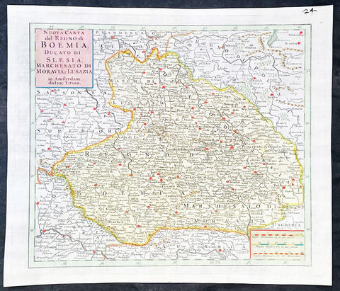
- Title : Nuova Carta del Regno di Boemia Ducato Di Slesia, Marches Ato Di Moravia e lusazia in Amsterdam da Isac Tirion
- Ref #: 35636
-
Condition: (A+) Fine Condition
- Size: 14 1/2in x 12 1/2in (365mm x 315mm)
- Date : 1740
- Price: $149US
Description:
This original hand coloured copper plate engraved antique map of the central European countries of the Kingdom of Bohemia, Duchy of Silesia, Marquisate of Moravia, and Lusatia by Isaac Tirion, was published in 1740 in Amsterdam.
General Definitions:
Paper thickness and quality: - Heavy and stable
Paper color : - off white
Age of map color: - Original
Colors used: - Yellow, green, blue, pink
General color appearance: - Authentic
Paper size: - 14 1/2in x 12 1/2in (365mm x 315mm)
Plate size: - 12 1/2in x 10 1/2in (315mm x 265mm)
Margins: - Min 1in (25mm)
Imperfections:
Margins: - None
Plate area: - None
Verso: - None
Background:
Bohemia is the westernmost and largest historical region of the Czech Republic. Bohemia can also refer to a wider area consisting of the historical Lands of the Bohemian Crown ruled by the Bohemian kings, including Moravia and Czech Silesia, in which case the smaller region is referred to as Bohemia proper as a means of distinction
Please note all items auctioned are genuine, we do not sell reproductions. A Certificate of Authenticity (COA) can be issued on request.
1750 Isaac Tirion Large Antique Map of Great Britain & Ireland
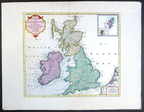
- Title : Nieuwe Kaaart van de Eilanden Groot Britannie behelsende Het Koningryk Engeland
- Ref #: 70087
- Size: 21 1/2in x 17in (545mm x 435mm)
- Date : 1750
- Condition: (A+) Fine Condition
Description:
This beautifully hand coloured original antique map of Great Britain & Ireland was published by Isaac Tirion in 1750.
Isaac Tirion was a successful publisher in Amsterdam during the 18th century who produced extensive volumes of Dutch town plans as well as a number of atlases with maps usually based on those of G. Delisle. His world atlases were finely engraved and beautifully colored as with this map for auction. (Ref: Tooley; M&B)
General Description:
Paper thickness and quality: - Heavy and stable
Paper color: - off white
Age of map color: - Original
Colors used: - Green, pink, yellow
General color appearance: - Authentic
Paper size: - 21 1/2in x 17in (545mm x 435mm)
Plate size: - 14 1/2in x 13in (370mm x 330mm)
Margins: - Min 1in (25mm)
Imperfections:
Margins: - None
Plate area: - None
Verso: - None
1765 Isaac Tirion Antique Print of an Alms House in Amsterdam, Holland
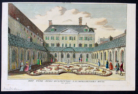
- Title : Het Oude-Zyds-Huiszitten-Aalmoesseniers-Huis, van agteren.
- Date : 1765
- Condition: (A+) Fine Condition
- Ref: Het1
- Size: 9in x 6in (230mm x 150mm)
Description:
This beautifully hand coloured original antique print of an Alms House in Amsterdam was published by Isaac Tirion in the 1765 edition ofTopografie van Nederland. (Ref: Tooley; M&B)
General Description:
Paper thickness and quality: - Heavy and stable
Paper color: - off white
Age of map color: - Early
Colors used: - Green, pink, yellow
General color appearance: - Authentic
Paper size: - 9in x 6in (230mm x 150mm)
Plate size: - 8 1/2in x 5 1/2in (215mm x 140mm)
Margins: - Min 1/4in (5mm)
Imperfections:
Margins: - None
Plate area: - None
Verso: - None
1765 Isaac Tirion Original Antique Map Southern North America, Mexico, Texas GOM
Antique Map
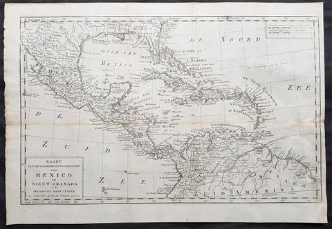
- Title : Kaart Van De Onderkoningschappen van Mexico en Nieuw Granada in de Spaansche West-Indien u Amsterdam by Isaac Tirion MDCCLXV (1765)
- Date : 1765
- Size: 20in x 14 1/2in (510mm x 370mm)
- Ref #: 70708
- Condition: (A) Very Good Condition
Description:
This scarce original 1765 antique map of Southern & Central North America, Mexico, New Spain, Florida, Louisiana, GOM, Caribbean, Central America & part of South America by Isaac Tirion was engraved in 1765 - dated in title.
General Definitions:
Paper thickness and quality: - Heavy and stable
Paper color : - off white
Age of map color: -
Colors used: -
General color appearance: -
Paper size: - 20in x 14 1/2in (510mm x 370mm)
Plate size: - 19in x 12in (485mm x 305mm)
Margins: - Min 1/2in (12mm)
Imperfections:
Margins: - Left fold re-joined
Plate area: - Folds as issued, light toning along center fold
Verso: - Light toning along center fold
Background:
The history of Mexico, a country in the southern portion of North America, covers a period of more than three millennia. First populated more than 13,000 years ago, the territory had complex indigenous civilizations before being conquered and colonized by the Spanish in the 16th century. One of the important aspects of Mesoamerican civilizations was their development of a form of writing, so that Mexico's written history stretches back hundreds of years before the arrival of the Spaniards in 1519. This era before the arrival of Europeans is called variously the prehispanic era or the precolumbian era.
The Aztec capital of Tenochtitlan became the Spanish capital Mexico City, which was and remains the most populous city in Mexico.
From 1521, the Spanish conquest of the Aztec empire incorporated the region into the Spanish Empire, with New Spain its colonial era name and Mexico City the center of colonial rule. It was built on the ruins of the Aztec capital of Tenochtitlan and became the capital of New Spain. During the colonial era, Mexico's long-established Mesoamerican civilizations mixed with European culture. Perhaps nothing better represents this hybrid background than Mexico's languages: the country is both the most populous Spanish-speaking country in the world and home to the largest number of Native American language speakers in North America. For three centuries Mexico was part of the Spanish Empire, whose legacy is a country with a Spanish-speaking, Catholic and largely Western culture.
After a protracted struggle (1810–21) for independence, New Spain became the sovereign nation of Mexico, with the signing of the Treaty of Córdoba. A brief period of monarchy (1821–23), called the First Mexican Empire, was followed by the founding of the Republic of Mexico, established under a federal constitution in 1824. Legal racial categories were eliminated, abolishing the system of castas. Slavery was not abolished at independence in 1821 or with the constitution in 1824, but was eliminated in 1829. Mexico continues to be constituted as a federated republic, under the Mexican Constitution of 1917.
The Age of Santa Anna is the period of the late 1820s to the early 1850s that was dominated by criollo military-man-turned-president Antonio López de Santa Anna. In 1846, the Mexican–American War was provoked by the United States, ending two years later with Mexico ceding almost half of its territory via the Treaty of Guadalupe Hidalgo to the United States. Even though Santa Anna bore significant responsibility for the disastrous defeat, he returned to office.
The Liberal Reform began with the overthrow of Santa Anna by Mexican liberals, ushering in La Reforma beginning in 1854. The Mexican Constitution of 1857 codified the principles of liberalism in law, especially separation of church and state, equality before the law, that included stripping corporate entities (the Catholic Church and indigenous communities) of special status. The Reform sparked a civil war between liberals defending the constitution and conservatives, who opposed it. The War of the Reform saw the defeat of the conservatives on the battlefield, but conservatives remained strong and took the opportunity to invite foreign intervention against the liberals in order to forward their own cause.
The French Intervention is the period when France invaded Mexico (1861), nominally to collect on defaulted loans to the liberal government of Benito Juárez, but it went further and at the invitation of Mexican conservatives seeking to restore monarchy in Mexico set Maximilian I on the Mexican throne. The US was engaged in its own Civil War (1861–65), so did not attempt to block the foreign intervention. Abraham Lincoln consistently supported the Mexican liberals. At the end of the civil war in the US and the triumph of the Union forces, the US actively aided Mexican liberals against Maximilian's regime. France withdrew its support of Maximilian in 1867 and his monarchist rule collapsed in 1867 and Maximilian was executed.
With the end of the Second Mexican Empire, the period often called the Restored Republic (1867–76) brought back Benito Juárez as president. Following his death from a heart attack, Sebastian Lerdo de Tejada succeed him. He was overthrown by liberal military man Porfirio Diaz, who after consolidating power ushered in a period of stability and economic growth. The half-century of economic stagnation and political chaos following independence ended.