
Georg Braun & Frans Hogenberg
Profile :
Braun and Hogenberg were two cartographers who are known for creating the famous Civitates Orbis Terrarum, which is considered one of the most important works of the 16th century. The Civitates Orbis Terrarum is a collection of city maps and views of European & New World cities, along with illustrations of important buildings, monuments, and notable people.
Georg Braun was born in Cologne, Germany, in 1541, and was a Catholic cleric who became the canon of the Cologne Cathedral. He was interested in geography and history and was a member of the Cologne Society of Antiquarians. Franz Hogenberg was a Flemish engraver born in Mechelen, Belgium, in 1535. He was trained as an artist and engraver and moved to Cologne in the 1560s, where he worked with Braun.
Braun and Hogenberg collaborated on the Civitates Orbis Terrarum, which was first published in 1572. The work was intended to be a comprehensive description of all the cities of the world, but only the cities of Europe were covered. The first edition of the Civitates Orbis Terrarum contained 546 views of cities, including maps and views of the most important cities of Europe. The work was an enormous undertaking and required the skills of many artists and engravers. The illustrations were based on contemporary maps and views, but the artists added their own interpretations and artistic touches to the images.
Braun and Hogenberg's work was highly influential and helped to shape the way that Europeans saw their cities and their world. The Civitates Orbis Terrarum was an important source of information about the cities of Europe, and it helped to stimulate interest in urban development and planning. The work was also an important contribution to the history of cartography and printing.
After the publication of the Civitates Orbis Terrarum, Braun and Hogenberg continued to work together on other projects, including an atlas of the world, which was published in 1575. Hogenberg died in 1590, but Braun continued to work on the Civitates Orbis Terrarum, publishing new editions until his death in 1622. The work continued to be popular and influential in the 17th and 18th centuries, and it remains an important historical and artistic achievement.
Georg Braun (1541 – 1622) was a topo-geographer. From 1572 to 1617 he edited the Civitates orbis terrarum, which contains 546 prospects, bird's-eye views and maps of cities from all around the world. He was the principal editor of the work, he acquired the tables, hired the artists, and wrote the texts. He died as an octogenarian in 1622, as the only survivor of the original team to witness the publication of volume VI in 1617. Braun was born and died in Cologne. His principal profession was as a Catholic cleric, however, he spent thirty-seven years as canon and dean at the church, St. Maria ad Gradus, in Cologne. His six-volume work was inspired by Sebastian Münster's Cosmographia. In form and layout it resembles the 1570 Theatrum orbis terrarum by Abraham Ortelius, as Ortelius was interested in a complementary companion for the Theatrum.
The Braun publication set new standards in cartography for over 100 years. Frans Hogenberg (1535–1590, from Mechelen) created the tables for volumes I through IV, and Simon van den Neuwel created those for volumes V and VI. Other contributors were Joris Hoefnagel, Jacob Hoefnagel, cartographer Daniel Freese, and Heinrich Rantzau. Also, works by Jacob van Deventer, Sebastian Münster, and Johannes Stumpf were used. Mainly, European cities are depicted in the publication, however, Casablanca and Mexico City/Cuzco on one sheet are also included in volume I.
Frans Hogenberg (1535 – 1590) was a Flemish and German painter, engraver, and mapmaker. Hogenberg was born in Mechelen as the son of Nicolaas Hogenberg. In 1568 he was banned from Antwerp by the Duke of Alva and travelled to London, where he stayed a few years before emigrating to Cologne. He is known for portraits and topographical views as well as historical allegories. He also produced scenes of contemporary historical events. Hogenberg died in Cologne.
Braun & Hogenberg (2)
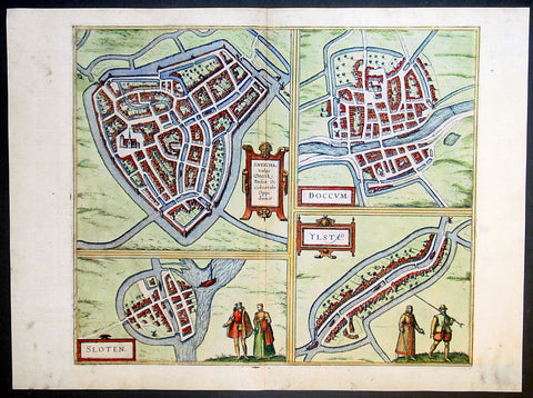
1575 Braun & Hogenberg Antique Print Sneek Dokkum Ylst Frisia Sloten Netherlands
- Title : Sneecha, vulgo Sneeck Frisiae Occidentalis Oppidum. - Doccum - Sloten - Ylsta
- Ref #: 30261
- Size: 21in x 16in (535mm x 410mm)
- Date : 1575
- Condition: (A+) Fine Condition
Description:
This fine beautifully hand coloured original antique map a birds-eye view of the towns of Sneek, Dokkum, Ylst and Sloten in Frisia, the Netherlands was published by Georg Braun & Frans Hogenberg for the 1575 atlas of town plans Civiates Orbis Terrarum Vol II (1572-1612) intended as a companion to Abraham Ortelius's master Atlas Theatrum Orbis Terrarum published in 1570.
Background of Civitates Orbis Terrarum
The first volume of the Civitates Orbis Terrarum was published in Cologne in 1572. The sixth and the final volume appeared in 1617.
This great city atlas, edited by Georg Braun and largely engraved by Franz Hogenberg, eventually contained 546 prospects, bird-eye views and map views of cities from all over the world. Braun (1541-1622), a cleric of Cologne, was the principal editor of the work, and was greatly assisted in his project by the close, and continued interest of Abraham Ortelius, whose Theatrum Orbis Terrarum of 1570 was, as a systematic and comprehensive collection of maps of uniform style, the first true atlas.
For a variety of reasons town plans were comparatively latecomers in the long history of cartography. Few cities in Europe in the middle ages had more than 20,00 inhabitants and even London in the late Elizabethan period had only 100-150,000 people which in itself was probably 10 times that of any other English city. The Nuremberg Chronicle in 1493 included one of the first town views of Jerusalem, thereafter, for most of the sixteenth century, German cartographers led the way in producing town plans in a modern sense. In 1544 Sebastian Munster issued in Basle his Cosmographia containing roughly sixty-six plans and views, some in the plan form, but many in the old panorama or birds eye view. (Ref: Tooley; M&B)
Condition Report:
Paper thickness and quality: - Heavy and stable
Paper color: - off white
Age of map color: - Early
Colors used: - Green, blue, red, yellow
General color appearance: - Authentic
Paper size: - 21in x 16in (535mm x 410mm)
Plate size: - 16 1/2in x 14in (420mm x 355mm)
Margins: - Min 1in (25mm)
Imperfections:
Margins: - Light soiling in margins
Plate area: - None
Verso: - None
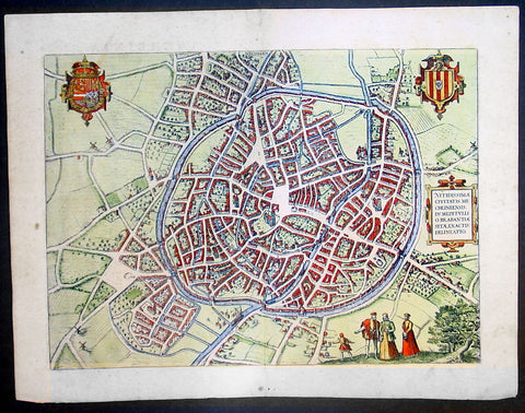
1575 Braun & Hogenberg Large Antique Print a View of Mechelen, Belgium
Antique Map
- Title : Mechelen - Nitidissimae Civitatis Mechlineensis in meditullio Brabantiae sitae, exactis: delineatio
- Ref #: 16247
- Size: 21in x 16in (535mm x 410mm)
- Date : 1575
- Condition: (A+) Fine Condition
Description:
This fine beautifully hand coloured original antique map a birds-eye view of the city of Mechelen in the Antwerp province of Flanders, Belgium was published by Georg Braun & Frans Hogenberg for the 1575 atlas of town plans Civiates Orbis Terrarum Vol II (1572-1612) intended as a companion to Abraham Ortelius's master Atlas Theatrum Orbis Terrarum published in 1570.
Franz Hogenberg's birthplace is illustrated twice. In the view presented in Volume I the cityscape is dominated by the massive tower belonging to the cathedral of Sint-Rombout, which measures almost 100 m in height. Behind the cathedral to the right lies the Onze-Lieve-Vrouwe church built in the Brabantine late Gothic style. In the present plate Mechelen is seen in a bird's-eye view from the northwest. Clearly apparent is the almost circular shape of the inner city, which has already spread beyond the bounds of the canal ringing the old city wall. In the Middle Ages staple rights and the cloth trade brought Mechelen great prosperity. In 1336 the city passed to the Duchy of Brabant, later to Burgundy, and developed into a highly regarded centre of commerce. The collapse of the cloth industry prompted the development of new areas of manufacturing, such as cannon and bell founding. In 1477 Mechelen passed to the Habsburgs and from 1507 to 1530, under the regency of Margaret of Austria, was capital of the Habsburg Netherlands. In 1559 Mechelen became an archbishopric and over the course of the Wars of Religion grew into a centre of the Counter-Reformation. For some time it was also the seat of the highest tribunal of the Habsburg Netherlands. (Taschen)
Background of Civitates Orbis Terrarum
The first volume of the Civitates Orbis Terrarum was published in Cologne in 1572. The sixth and the final volume appeared in 1617.
This great city atlas, edited by Georg Braun and largely engraved by Franz Hogenberg, eventually contained 546 prospects, bird-eye views and map views of cities from all over the world. Braun (1541-1622), a cleric of Cologne, was the principal editor of the work, and was greatly assisted in his project by the close, and continued interest of Abraham Ortelius, whose Theatrum Orbis Terrarum of 1570 was, as a systematic and comprehensive collection of maps of uniform style, the first true atlas.
For a variety of reasons town plans were comparatively latecomers in the long history of cartography. Few cities in Europe in the middle ages had more than 20,00 inhabitants and even London in the late Elizabethan period had only 100-150,000 people which in itself was probably 10 times that of any other English city. The Nuremberg Chronicle in 1493 included one of the first town views of Jerusalem, thereafter, for most of the sixteenth century, German cartographers led the way in producing town plans in a modern sense. In 1544 Sebastian Munster issued in Basle his Cosmographia containing roughly sixty-six plans and views, some in the plan form, but many in the old panorama or birds eye view. (Ref: Tooley; M&B)
Condition Report:
Paper thickness and quality: - Heavy and stable
Paper color: - off white
Age of map color: - Early
Colors used: - Green, blue, red, yellow
General color appearance: - Authentic
Paper size: - 21in x 16in (535mm x 410mm)
Plate size: - 18 1/2in x 13 1/2in (470mm x 345mm)
Margins: - Min 1in (25mm)
Imperfections:
Margins: - Light soiling in margins
Plate area: - None
Verso: - None