
Georg Braun & Frans Hogenberg
Profile :
Braun and Hogenberg were two cartographers who are known for creating the famous Civitates Orbis Terrarum, which is considered one of the most important works of the 16th century. The Civitates Orbis Terrarum is a collection of city maps and views of European & New World cities, along with illustrations of important buildings, monuments, and notable people.
Georg Braun was born in Cologne, Germany, in 1541, and was a Catholic cleric who became the canon of the Cologne Cathedral. He was interested in geography and history and was a member of the Cologne Society of Antiquarians. Franz Hogenberg was a Flemish engraver born in Mechelen, Belgium, in 1535. He was trained as an artist and engraver and moved to Cologne in the 1560s, where he worked with Braun.
Braun and Hogenberg collaborated on the Civitates Orbis Terrarum, which was first published in 1572. The work was intended to be a comprehensive description of all the cities of the world, but only the cities of Europe were covered. The first edition of the Civitates Orbis Terrarum contained 546 views of cities, including maps and views of the most important cities of Europe. The work was an enormous undertaking and required the skills of many artists and engravers. The illustrations were based on contemporary maps and views, but the artists added their own interpretations and artistic touches to the images.
Braun and Hogenberg's work was highly influential and helped to shape the way that Europeans saw their cities and their world. The Civitates Orbis Terrarum was an important source of information about the cities of Europe, and it helped to stimulate interest in urban development and planning. The work was also an important contribution to the history of cartography and printing.
After the publication of the Civitates Orbis Terrarum, Braun and Hogenberg continued to work together on other projects, including an atlas of the world, which was published in 1575. Hogenberg died in 1590, but Braun continued to work on the Civitates Orbis Terrarum, publishing new editions until his death in 1622. The work continued to be popular and influential in the 17th and 18th centuries, and it remains an important historical and artistic achievement.
Georg Braun (1541 – 1622) was a topo-geographer. From 1572 to 1617 he edited the Civitates orbis terrarum, which contains 546 prospects, bird's-eye views and maps of cities from all around the world. He was the principal editor of the work, he acquired the tables, hired the artists, and wrote the texts. He died as an octogenarian in 1622, as the only survivor of the original team to witness the publication of volume VI in 1617. Braun was born and died in Cologne. His principal profession was as a Catholic cleric, however, he spent thirty-seven years as canon and dean at the church, St. Maria ad Gradus, in Cologne. His six-volume work was inspired by Sebastian Münster's Cosmographia. In form and layout it resembles the 1570 Theatrum orbis terrarum by Abraham Ortelius, as Ortelius was interested in a complementary companion for the Theatrum.
The Braun publication set new standards in cartography for over 100 years. Frans Hogenberg (1535–1590, from Mechelen) created the tables for volumes I through IV, and Simon van den Neuwel created those for volumes V and VI. Other contributors were Joris Hoefnagel, Jacob Hoefnagel, cartographer Daniel Freese, and Heinrich Rantzau. Also, works by Jacob van Deventer, Sebastian Münster, and Johannes Stumpf were used. Mainly, European cities are depicted in the publication, however, Casablanca and Mexico City/Cuzco on one sheet are also included in volume I.
Frans Hogenberg (1535 – 1590) was a Flemish and German painter, engraver, and mapmaker. Hogenberg was born in Mechelen as the son of Nicolaas Hogenberg. In 1568 he was banned from Antwerp by the Duke of Alva and travelled to London, where he stayed a few years before emigrating to Cologne. He is known for portraits and topographical views as well as historical allegories. He also produced scenes of contemporary historical events. Hogenberg died in Cologne.
Braun & Hogenberg (1)
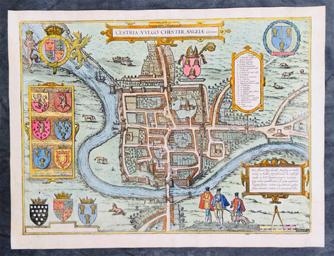
1574 Braun & Hogenberg Antique Map View of The City of Chester, Cheshire England
Antique Map
- Title : Cestria Vvlgo Chester Angliae Civitas
- Ref #: 27092
- Size: 18 1/2in x 14in (470mm x 355mm)
- Date : 1574
- Condition: (A) Very Good Condition
Description:
This original beautifully hand coloured copper plate engraved antique map, a birds eye view of the city of Chester in Cheshire, England, was published in the 1574 edition of Braun & Hogenbergs atlas Civitates Orbis Terrarum
General Definitions:
Paper thickness and quality: - Heavy and stable
Paper color : - off white
Age of map color: - Original
Colors used: - Yellow, green, blue, pink
General color appearance: - Authentic
Paper size: - 18 1/2in x 14in (470mm x 355mm)
Plate size: - 15 1/2in x 12 3/4in (390mm x 325mm)
Margins: - Min 1/2in (12mm)
Imperfections:
Margins: - Several small worm holes restored in margins
Plate area: - Several small worm holes restored
Verso: - Several small worm holes restored