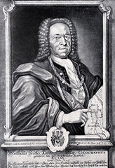
Georg Matthaus Seutter (1678-1756)
Profile :
After serving an apprenticeship to J.B. Homann, the successful map publisher, Seutter set up his own very successful business in Augsburg and was appointed Geographer to the Imperial Court. With his son and son-in-law, Conrad Lotter, he issued in about 1741 a large series of town plans. For much of his life he worked in competition with his old employer and, not surprisingly, his maps were often similar to those of Homann.
Georg Matthaus Seutter (2)
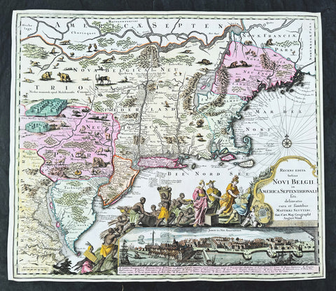
1730 Georg Seutter Antique Map of New England & New York City - Rare 2nd State
Antique Map
- Title : Recens edita totius Novi Belgii, in America Septentrionali siti, delineatio cura et sumtibus Matthaei Seutteri, Sac. Caes Maj. Geographf. August. Vind
- Size: 23in x 20 1/4in (585mm x 515mm)
- Condition: (A) Very Good Condition
- Date : 1730
- Ref #: 43001
Description:
This large beautifully hand coloured original antique map of the NE region of colonial North America, with the famous Restitutio inset birds-eye view of 17th century New York city, was engraved & published by Georg Mattraus Seutter in 1730.
This is the rare second state, identified by the omission of Chalcographi Augustani from the title and the blank shaded are directly below the title (text was added to the shaded area in the 3rd to 6th states) The cartouche and city view are uncoloured as was intended by Seutter along with the beautiful original map colouring.
This map is in exceptional condition with beautiful original colour, with heavy engraving (denoting an early pressing) on clean heavy sturdy paper. The top and left borders have been professionally extended, with no impact on the image.
There are, at the time of listing, nine of these maps for sale online, of states 2 to 6. Of the 9 only 2 are of the rare 2nd state. The average asking price of the nine maps is $4897US.
General Definitions:
Paper thickness and quality: - Heavy and stable
Paper color : - off white
Age of map color: - Original
Colors used: - Blue, pink, red, green, yellow
General color appearance: - Authentic
Paper size: - 23in x 20 1/4in (585mm x 515mm)
Plate size: - 23in x 20 1/4in (585mm x 515mm)
Margins: - Min 1/4in (5mm)
Imperfections:
Margins: - T, R & L margins extended
Plate area: - None
Verso: - None
Background:
The map is based upon the Jansson-Visscher New England series of maps, first published by Visscher in 1651. Seutter replaces the original Restitutio view of New York City with a new view of New York entitled Neu Jorck sive Neu Amsterdam, with a key to the view below in Latin. Above the view is an elaborate scene depicting natives, slaves & allegorical deities presenting tributes to the English monarch, George II. The course of the Delaware and Hudson are separated, unlike early editions of the map.
This is the first map in the series to show distinct drawn boundaries between Massachusetts, New England, New York, New Jersey and Pennsylvania, as earlier examples had previously left the delineation of the boundaries to the colorist. Philadelphia is now shown as a set of houses in relief, rather than a ground plan. The map is richly embellished with many animals and other decorations and is without doubt, one of the most decorative 18th century maps of the region.
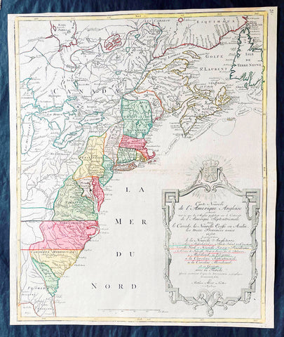
1776 Tobias Lotter Large Antique Post Revolutionary North America Map 13 Colonies
Antique Map
- Title : Carte Nouvelle de l Amerique Angloise Contenant Tout ce que les Anglois Possedent sur le Continent de l'Amerique Septentrionale Savior le Canada, la Nouvelle Ecosse ou Acadie, les Treize Provinces Unies ... avec la Floride
- Ref #: 27009
-
Condition: (A+) Fine Condition
- Size: 25in x 21 1/2in (635mm x 545mm)
- Date : 1776
Description:
This is possibly one of the last significant maps, of the original 13 American colonies, published prior to the American Revolution for Independence from Britain, beginning in 1763 and ending with the signing of the Declaration of Independence in 1776.
Published in Augsberg, Germany in 1776 by Conrad Tobias Lotter, this large original antique map reflects both the French & German interests in North America just prior to the outbreak of hostilities.
The map covers the area from the James Bay to the Gulf of Mexico and west to Lake Michigan. It shows provinces, towns and cities, some forts and trails, as well as Indian villages and tribal territory. (Ref: Tooley, M&B)
General Definitions:
Paper thickness and quality: - Heavy and stable
Paper color : - off white
Age of map color: - Original & later
Colors used: - Yellow, green, blue, pink
General color appearance: - Authentic
Paper size: - 25in x 21 1/2in (635mm x 545mm)
Plate size: - 24in x 19 1/2in (610mm x 495mm)
Margins: - Min 1/2in (12mm)
Imperfections:
Margins: - None
Plate area: - None
Verso: - None
Background:
Each of the thirteen Colonies is identified by name both on the map, and in the title. The title is placed within an attractive decorative border surmounted by the British Royal arms. The French title and nomenclature indicates that Lotter, a leading German mapmaker, intended this for the French market, as does the fact that he limits the claims of the British to the regions east of the Appalachian Mountains. The delineation of the thirteen Provinces unies is generally well done (although Maryland and Georgia are both strangely shaped): a number of locations are named in the Ohio Valley, including Logs Town, Twictwees, Ft. Du Quesne, Allegheny, Vinango, Buffaloons, Sandoski and Mingos. Some interesting details are also shown in the region of the Great Lakes.
Please note all items auctioned are genuine, we do not sell reproductions. A Certificate of Authenticity (COA) can be issued on request.