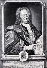
Georg Matthaus Seutter (1678-1756)
Profile :
After serving an apprenticeship to J.B. Homann, the successful map publisher, Seutter set up his own very successful business in Augsburg and was appointed Geographer to the Imperial Court. With his son and son-in-law, Conrad Lotter, he issued in about 1741 a large series of town plans. For much of his life he worked in competition with his old employer and, not surprisingly, his maps were often similar to those of Homann.
Georg Matthaus Seutter (1)
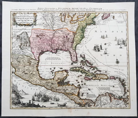
1730 Matthaus Seutter Large Antique Map of British, French Spanish North America
- Title : Mappa Geographica Regionem Mexicanam et Floridam. Terrasque adjacentes ut et Anteriors Americae Insulas Cursus itidem et Reditus Navigantium versus flumen Missisipi et alais Colonias ob oculos ponens eura et sumptibus Matthaei Seutteri S. Caes et Reg Cath Maj, Geograph et Chalcographi Augustae Vindel...Tob. Con. Lotter Sculps
- Date : 1730
- Condition: (A) Very Good Condition
- Ref: 42019
- Size: 25 1/2in x 22in (650mm x 560mm)
Description:
This beautifully hand coloured original antique map is one of the best, engraved by Tobias Conrad Lotter and published by Matthaus Seutter in 1730.
One of the best and most beautifully executed, iconic 18th century antique maps of colonial North America. Engraved after the 1703 map of North America by Guillaume Delisle, it was re-issued by a number of famous 18th century cartographers.
The ongoing and the changing ownership of North America is illustrated in the specific demarcation of the British, French and Spanish regions. To the right & bottom left of the map is illustrated using naval battles, with the various ships flying the British, French & Spanish flags.
This map is a must for any North American collection, with beautiful original hand colour, a heavy impression (denoting an early pressing) on heavy sturdy paper with original margins, an exciting map .
General Definitions:
Paper thickness and quality: - Heavy and stable
Paper color : - off white
Age of map color: - Original
Colors used: - Yellow, green, blue, pink
General color appearance: - Authentic
Paper size: - 25 1/2in x 22in (650mm x 560mm)
Plate size: - 23in x 19 3/4in (585mm x 500mm)
Margins: - Min 1in (25mm)
Imperfections:
Margins: - None
Plate area: - Light discolouration to Nova Francia around great lakes
Verso: - Backed onto archival tissue, centerfold re-enforced
Background:
The importance of this landmark map of North America cannot be overstated. It was the first map to accurately depict the course and mouth of the Mississippi River. Much of the map was drawn from reports brought back to France from the survivor\\\'s of the La Salle expedition into the interior of North America and from information derived from the explorations of Bienville and d Iberville. In the year preceding the publication of the map, Delisle utilised his position with the King of France to gain access to the best available information from the new world.
During this time, he compiled the geographical data from the reports of the French Jesuit Missionaries and explorers in North America, along with Spanish manuscript maps (often copied by the Missionaries while they were acting in the service of the Spanish as spiritual guides and gaining their confidence). The result of this work were a series of 4 landmark maps of America, including his map of North America (L Amerique Septentrionale, 1700), Canada and the Great Lakes (Carte du Canada ou de la Nouvelle France 1703) and the Mississippi Valley & Gulf Coast (Carte de la Louisiane et du Cours du Mississipi 1708) and of course this map.
Carl Wheat called this map a towering landmark along the path of Western cartographic development. This map also included greater accuracy in the Great Lakes region and in its depiction of English settlements along the East Coast. Excellent detail of the Indian villages in East Texas, based upon the reports of Iberville and the Spanish missionaries. The best depiction of the Southwest to date, with early trails & Indian tribes. Cumming described the map as profoundly influential. (Ref: Cummings; M&B; Tooley)
Seutter, Matthaus 1678 - 1757
Seutter was one of the most important and prolific German map publishers of the 18th century. Seutter started his career as an apprentice brewer. Apparently uninspired by the beer business, Seutter left his apprenticeship and moved to Nuremberg where he apprenticed as an engraver under the tutelage of the prominent J. B. Homann. Sometime in the early 18th century Seutter left Homann to establish his own independent cartographic publishing firm in Augsburg. Though he struggled in the early years of his independence, Seutters engraving skill and commitment to diversified map production eventually gained him a substantial following. Most of Seutters maps were heavily based upon, if not copies of, earlier work done by the Homann and Delisle firms.
By 1732 Seutter was one of the most prolific publishers of his time and was honored by the German Emperor Charles VI with the title of Imperial Geographer. Seutter continued to publish until his death, at the height of his career, in 1757. The Seutter firm continued under Seutters wastrel son Albrecht Carl until his death in 1762. Following Albrechts death, the firm was divided between the established Probst firm and the emerging firm of Tobias Conrad Lotter. Lotter, Seutters son in law, was a master engraver and worked on behalf of the Seutter firm. Lotter would eventually become one of the most prominent cartographers of his day.
Please note all items auctioned are genuine, we do not sell reproductions. A Certificate of Authenticity (COA) can be issued on request.