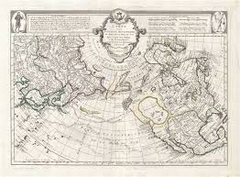
Francois Santini (c. 1729 - 1784)

Francesco (Francois) Santini was an Italian cartographer and publisher who lived in Venice. He was a member of a family of publishers who specialized in producing maps and atlases, and his own contributions to the field helped to establish him as an important figure in the 18th-century cartographic world.
Santini was born in Venice around 1729 and was the son of Paolo Santini, a prominent map publisher. In the mid-18th century, he joined his father's business and began to produce maps and atlases of his own. Santini collaborated with other prominent cartographers of the time, including Jean-Baptiste Nolin and Giovanni Rizzi Zannoni, and his works were highly regarded for their accuracy and detail.
One of Santini's most important contributions to the field of cartography was his publication of a multi-volume atlas called the "Atlas Universel," which was first published in 1776. The atlas contained maps of all the known regions of the world, and was notable for its use of the latest scientific and geographical information available at the time. Santini's maps were known for their detail and accuracy, and were highly regarded by both scholars and navigators.
Santini died in Venice in 1784, but his legacy continued through the work of his family's publishing business. His maps and atlases continued to be produced and updated by his son and grandson, and the Santini family's cartographic output remained an important resource for scholars and explorers throughout the 18th and 19th centuries. Today, Santini's works are highly prized by collectors and are regarded as important examples of 18th-century cartography.
Francois Santini (3)
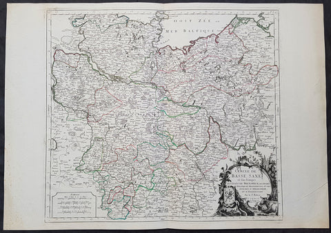
1778 Santini Antique Map Lower Saxon Circle Germany, Holstien Bremen Mecklenburg
- Title : Cercle de Basse Saxe on sont distingues Les Etats de Brunswich Les Duches De Holstien...Par L Sr Robert....A Venise...P Santini...1778
- Date : 1778
- Condition: (A+) Fine Condition
- Ref: 50203
- Size: 30in x 21in (760mm x 535mm)
Description:
This large magnificent original copper-plate engraved antique map of The Lower Saxon Circle of Northern Germany, was engraved in 1778 - the date is engraved in the title cartouche - after Robert De Vaugondy and was published by Francois Santini (active 1776-84) in his 2 volume edition of Atlas Universal 1776-84. (Ref: Tooley; M&B)
General Definitions:
Paper thickness and quality: - Heavy and stable
Paper color : - off white
Age of map color: - Original
Colors used: - Blue, pink, red, green, yellow
General color appearance: - Authentic
Paper size: - 30in x 21in (760mm x 535mm)
Plate size: - 22in x 19 1/2in (560mm x 495mm)
Margins: - Min 1in (25mm)
Imperfections:
Margins: - None
Plate area: - None
Verso: - None
Background:
The Lower Saxon Circle was an Imperial Circle of the Holy Roman Empire. It covered much of the territory of the medieval Duchy of Saxony (except for Westphalia), and was originally called the Saxon Circle (German: Sächsischer Kreis) before later being better differentiated from the Upper Saxon Circle by the more specific name.
An unusual aspect of this circle was that, at various times, the kings of Denmark (in Holstein), Great Britain (in Hanover) and Sweden (in Bremen) were all Princes of a number of Imperial States.
The Lower Saxon Circle included the easternmost part of current Lower Saxony, the northernmost part of Saxony-Anhalt (excluding the Altmark), Mecklenburg, Holstein (excluding Dithmarschen), Hamburg, Bremen, in addition to small areas in Brandenburg and Thuringia. For the most part it was a continuous territory with the exception of small enclaves like Halle and Jüterbog. Nordhausen and Mühlhausen were also areas outside the continuous portion of the imperial circle. Within the circle was the Archbishopric of Verden, which was in personal union with the Archbishopric of Bremen since 1502. The Counties of Schaumburg and Spiegelberg were also part of the personal union, but they were not a part of the Lower Saxon Circle.
By the downfall of the Holy Roman Empire, the circle was 1 240 square miles large, with 2 120 000 inhabitants. With respect to religion, almost all the citizens were Protestant. The exception was the partially Catholic Bishopric of Hildesheim.
During the Early Modern period the Holy Roman Empire was divided into Imperial Circles administrative groupings whose primary purposes were the organization of common defensive structure and the collection of imperial taxes. They were also used as a means of organization within the Imperial Diet and the Imperial Chamber Court. Each circle had a Circle Diet, although not every member of the Circle Diet would hold membership of the Imperial Diet as well.
Six Imperial Circles were introduced at the Diet of Augsburg in 1500. In 1512, three more circles were added, and the large Saxon Circle was split into two, so that from 1512 until the collapse of the Holy Roman Empire in the Napoleonic era, there were ten Imperial Circles. The Crown of Bohemia, the Swiss Confederacy and Italy remained unencircled, as did various minor territories which held imperial immediacy.
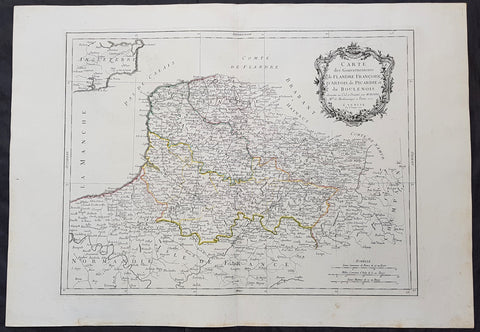
1777 F. Santini Antique Map Flanders Artois Hainaut Picardy Regions of Belgium
- Title : Carte Des Gouvernements de Flandre Francois d Artois de Picardie et du Boulenois...P Santini...1777
- Size: 30in x 21in (760mm x 535mm)
- Condition: (A+) Fine Condition
- Date : 1777
- Ref #: 50219
Description:
This large magnificent original copper-plate engraved antique map of Belgium and parts of Northern France made up of the provinces of Flanders, Artois, Hainaut, Picardy was engraved in 1777 - the date is engraved in the title cartouche - after Rigobert Bonne in 1771 and was published by Francois Santini (active 1776-84) in his 2 volume edition of Atlas Universal 1776-84.. (Ref: Tooley; M&B)
General Definitions:
Paper thickness and quality: - Heavy and stable
Paper color : - off white
Age of map color: - Original
Colors used: - Blue, pink, red, green, yellow
General color appearance: - Authentic
Paper size: - 30in x 21in (760mm x 535mm)
Plate size: - 23in x 18in (585mm x 460mm)
Margins: - Min 2in (50mm)
Imperfections:
Margins: - None
Plate area: - None
Verso: - None
Background:
Belgium officially the Kingdom of Belgium, is a country in Western Europe bordered by France, the Netherlands, Germany and Luxembourg.
Historically, Belgium was part of an area known as the Low Countries, a somewhat larger region than the current Benelux group of states that also included parts of northern France and western Germany. Its name is derived from the Latin word Belgica, after the Roman province of Gallia Belgica. From the end of the Middle Ages until the 17th century, the area of Belgium was a prosperous and cosmopolitan centre of commerce and culture. Between the 16th and early 19th centuries, Belgium served as the battleground between many European powers, earning the moniker the Battlefield of Europe, a reputation strengthened by both world wars. The country emerged in 1830 following the Belgian Revolution when it seceded from the Netherlands.
The Eighty Years War (1568–1648) divided the Low Countries into the northern United Provinces (Belgica Foederata in Latin, the Federated Netherlands) and the Southern Netherlands (Belgica Regia, the Royal Netherlands). The latter were ruled successively by the Spanish (Spanish Netherlands) and the Austrian Habsburgs (Austrian Netherlands) and comprised most of modern Belgium. This was the theatre of most Franco-Spanish and Franco-Austrian wars during the 17th and 18th centuries.
Following the campaigns of 1794 in the French Revolutionary Wars, the Low Countries—including territories that were never nominally under Habsburg rule, such as the Prince-Bishopric of Liège—were annexed by the French First Republic, ending Austrian rule in the region. The reunification of the Low Countries as the United Kingdom of the Netherlands occurred at the dissolution of the First French Empire in 1815, after the defeat of Napoleon.
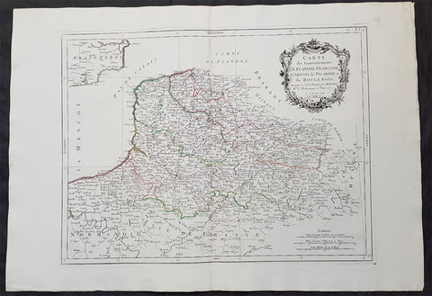
1777 F. Santini Antique Map Flanders Artois Hainaut Picardy Regions of Belgium
- Title : Carte Des Gouvernements de Flandre Francois d Artois de Picardie et du Boulenois...P Santini...1777
- Size: 30in x 21in (760mm x 535mm)
- Condition: (A+) Fine Condition
- Date : 1777
- Ref #: 50221
Description:
This large magnificent original copper-plate engraved antique map of Belgium and parts of Northern France made up of the provinces of Flanders, Artois, Hainaut, Picardy was engraved in 1777 - the date is engraved in the title cartouche - after Rigobert Bonne in 1771 and was published by Francois Santini (active 1776-84) in his 2 volume edition of Atlas Universal 1776-84.. (Ref: Tooley; M&B)
General Definitions:
Paper thickness and quality: - Heavy and stable
Paper color : - off white
Age of map color: - Original
Colors used: - Blue, pink, red, green, yellow
General color appearance: - Authentic
Paper size: - 30in x 21in (760mm x 535mm)
Plate size: - 23in x 18in (585mm x 460mm)
Margins: - Min 2in (50mm)
Imperfections:
Margins: - None
Plate area: - None
Verso: - None
Background:
Belgium officially the Kingdom of Belgium, is a country in Western Europe bordered by France, the Netherlands, Germany and Luxembourg.
Historically, Belgium was part of an area known as the Low Countries, a somewhat larger region than the current Benelux group of states that also included parts of northern France and western Germany. Its name is derived from the Latin word Belgica, after the Roman province of Gallia Belgica. From the end of the Middle Ages until the 17th century, the area of Belgium was a prosperous and cosmopolitan centre of commerce and culture. Between the 16th and early 19th centuries, Belgium served as the battleground between many European powers, earning the moniker the Battlefield of Europe, a reputation strengthened by both world wars. The country emerged in 1830 following the Belgian Revolution when it seceded from the Netherlands.
The Eighty Years War (1568–1648) divided the Low Countries into the northern United Provinces (Belgica Foederata in Latin, the Federated Netherlands) and the Southern Netherlands (Belgica Regia, the Royal Netherlands). The latter were ruled successively by the Spanish (Spanish Netherlands) and the Austrian Habsburgs (Austrian Netherlands) and comprised most of modern Belgium. This was the theatre of most Franco-Spanish and Franco-Austrian wars during the 17th and 18th centuries.
Following the campaigns of 1794 in the French Revolutionary Wars, the Low Countries—including territories that were never nominally under Habsburg rule, such as the Prince-Bishopric of Liège—were annexed by the French First Republic, ending Austrian rule in the region. The reunification of the Low Countries as the United Kingdom of the Netherlands occurred at the dissolution of the First French Empire in 1815, after the defeat of Napoleon.