
Emmanuel Bowen (1714 - 1767) Thomas Bowen (died 1790)
Profile :
Emmanuel Bowen and his son Thomas Bowen were a prominent father-son duo of cartographers in 18th century England.
Emmanuel Bowen was born in Wales in 1714 and moved to London in his early twenties. He became an apprentice under the engraver Charles Price and later established his own business as a map engraver and publisher. Bowen quickly gained a reputation for his skill in engraving and his expertise in cartography.
In 1747, Emmanuel Bowen was appointed as Mapmaker to George II, a position that gave him access to the latest geographic information and helped establish his reputation as a leading cartographer. Bowen produced a number of important maps and atlases during his career, including a series of county maps of England and Wales and a world atlas titled "A Complete Atlas, or Distinct View of the Known World," which was published in 1752.
After Emmanuel Bowen's death in 1767, his son Thomas took over the family business. Thomas was also a skilled cartographer and continued to publish maps and atlases under the name of his father's business. Some of the notable works produced by Thomas Bowen include a map of the British colonies in North America and a map of the West Indies.
Emmanuel and Thomas Bowen are known for their accurate and detailed maps, which were highly sought after by collectors and scholars of the time. Their maps are characterized by their attention to detail, clarity, and elegance of design. The Bowen family's maps were used extensively in schools and libraries, and their legacy as prominent cartographers has been recognized for centuries.
Emmanuel & Thomas Bowen (2)
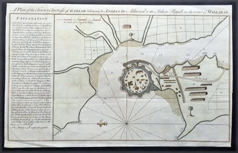
1760 Bowen Antique Map, Plan Fort & Town of Vijaydurg, Maharashtra State, India
- Title : A plan of the town and fortress of Gariah belonging to Angriah the admiral to the Sahou Rajah
- Size: 18 1/4in x 12in (465mm x 305mm)
- Condition: (A+) Fine Condition
- Date : 1760
- Ref #: 21950
Description:
This beautifully hand coloured original copper-plate engraved antique map, a plan of the fort and town of Gheriah, Girye or Gheriya, today called Vijaydurg in Maharashtra state in NW India (485 kms from Mumbai) was published by Emmanual Bowen in 1760.
The map contains many numbered & lettered references to particular areas of interest within the fort, town and surrounds.
General Definitions:
Paper thickness and quality: - Heavy and stable
Paper color : - off white
Age of map color: -
Colors used: -
General color appearance: -
Paper size: - 18 1/4in x 12in (465mm x 305mm)
Plate size: - 18 1/4in x 12in (465mm x 305mm)
Margins: - Min 1/2in (12mm)
Imperfections:
Margins: - Light creasing
Plate area: - Folds as issued
Verso: - Folds as issued
Background:
Vijaydurg is said to be the oldest fort in Sindhudurg coast. In the Pre-Independence era it was also known as Eastern Gibraltar. This is because the fort was almost unconquerable. Under the leadership of Kanhoji Angre, it withstood many naval attacks by the British and the Dutch. Kanhoji Angre died on 4 July 1729 and the Angres control of the fort ended in 1756 after the Peshwa-British Alliance defeated the Angres clan. In 1818 Vijaydurg was completely in the hand of the British Empire.
Kanhoji Angre 1669 – 1729 was a chief of the Maratha Navy in 18th century India. In historical records, he is also known as Conajee Angria or Sarkhel Angré (Sarkhel is a title equal to Admiral of a fleet).
Kanhoji fought against the British, Dutch and Portuguese naval interests on the coasts of India during the 18th century. As a result, his European enemies labeled him a pirate. Despite the attempts of the British and Portuguese to subdue Angre, he remained undefeated until his death.
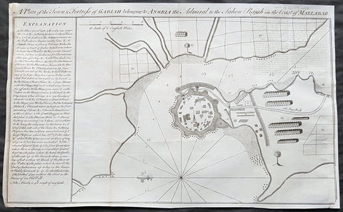
1760 Bowen Antique Map, Plan Fort & Town of Vijaydurg, Maharashtra State, India
- Title : A plan of the town and fortress of Gariah belonging to Angriah the admiral to the Sahou Rajah
- Size: 18 1/4in x 12in (465mm x 305mm)
- Condition: (A+) Fine Condition
- Date : 1760
- Ref #: 40986-2
Description:
This original copper-plate engraved antique map, a plan of the fort and town of Gheriah, Girye or Gheriya, today called Vijaydurg in Maharashtra state in NW India (485 kms from Mumbai) was published by Emmanual Bowen in 1760.
The map contains many numbered & lettered references to particular areas of interest within the fort, town and surrounds.
General Definitions:
Paper thickness and quality: - Heavy and stable
Paper color : - off white
Age of map color: -
Colors used: -
General color appearance: -
Paper size: - 18 1/4in x 12in (465mm x 305mm)
Plate size: - 18 1/4in x 12in (465mm x 305mm)
Margins: - Min 1/2in (12mm)
Imperfections:
Margins: - Light creasing
Plate area: - Folds as issued
Verso: - Folds as issued
Background:
Vijaydurg is said to be the oldest fort in Sindhudurg coast. In the Pre-Independence era it was also known as Eastern Gibraltar. This is because the fort was almost unconquerable. Under the leadership of Kanhoji Angre, it withstood many naval attacks by the British and the Dutch. Kanhoji Angre died on 4 July 1729 and the Angres control of the fort ended in 1756 after the Peshwa-British Alliance defeated the Angres clan. In 1818 Vijaydurg was completely in the hand of the British Empire.
Kanhoji Angre 1669 – 1729 was a chief of the Maratha Navy in 18th century India. In historical records, he is also known as Conajee Angria or Sarkhel Angré (Sarkhel is a title equal to Admiral of a fleet).
Kanhoji fought against the British, Dutch and Portuguese naval interests on the coasts of India during the 18th century. As a result, his European enemies labeled him a pirate. Despite the attempts of the British and Portuguese to subdue Angre, he remained undefeated until his death.