
Louis de Freycinet (1779 – 1841)
Background:
He was born at Montélimar, Drôme. Louis-Claude de Saulces de Freycinet was his full name (many calling him Louis de Freycinet). He had three brothers, Louis-Henri de Saulces de Freycinet, André-Charles de Saulces de Freycinet and the youngest, Frédéric-Casimir de Saulces de Freycinet (father of Charles de Freycinet). Louis-Claude was the second oldest. In 1793 he entered the French navy. After taking part in several engagements against the British, he joined in 1800, along with his brother (Louis-Henri de Freycinet (1777–1840), who afterwards rose to the rank of admiral), an expedition to explore the south and south-west coasts of Australia. It set out under Nicolas Baudin in the ships Naturaliste and Géographe. Much of the ground already gone over by Matthew Flinders was revisited, and new names imposed by this expedition, which claimed credit for discoveries really made by the English navigator. In the end, Baudin and Freycinet managed to have their map of the Australian coastline published in 1811, three years before Flinders published his.
An inlet on the coast of Western Australia is called Freycinet Estuary. Cape Freycinet between Cape Leeuwin and Cape Naturaliste and the Freycinet Peninsula with Freycinet National Park in Tasmania also bear the explorer's name.
In 1805, he returned to Paris, and was entrusted by the government with the work of preparing the maps and plans of the expedition. He also completed the narrative, and the whole work appeared under the title of Voyage de découvertes aux terres australes (Paris, 1807–1816).années 1817, 1818, 1819 et 1820, in 13 quarto volumes and 4 folio volumes of plates and maps.
In 1817, he commanded the Uranie, in which the marine hydrologist Louis Isidore Duperrey, the artist Jacques Arago, his junior draughtsman Adrien Taunay the Younger, and others, with a guard of seventeen officers, sailed to Rio de Janeiro, to take a series of pendulum measurements as well as a larger scheme for obtaining observations, not only in geography and ethnology, but in astronomy, terrestrial magnetism, and meteorology, and for the collection of specimens in natural history. Freycinet also managed to sneak his wife Rose de Freycinet aboard.
For three years, Freycinet cruised about the Pacific, visiting Australia, the Mariana Islands, Hawaiian Islands, and other Pacific islands, South America, and other places, and, notwithstanding the loss of the Uranie on the Falkland Islands during the return voyage, returned to France with fine collections in all departments of natural history, and with voluminous notes and drawings of the countries visited.
The results of this voyage were published under Freycinet's supervision, with the title of Voyage autour du monde fait par ordre du Roi sur les corvettes de S. M. l'Uranie et la Physicienne, pendant les années 1817, 1818, 1819 et 1820, in 13 quarto volumes and 4 folio volumes of plates and maps.
Freycinet was admitted into the French Academy of Sciences in 1825, and was one of the founders of the Paris Geographical Society. He died at the family's château de Freycinet[4] near Saulce-sur-Rhône, Drôme
Louis de Freycinet (2)
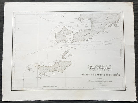
1803 Louis Freycinet Antique Map of The Islands of Timor, Samau & Rote Indonesia
- Title : Carte Particuliere des Detroits De Rottie et de Simao...L Freycienet...le Casuarina 1803..Lambert Sculp.
- Ref #: 42014
- Size: 22 1/2in x 16 1/2in (570mm x 420mm)
- Date : 1803
- Condition: (A+) Fine Condition
Description:
This magnificent large original copper-plate engraved antique map of the islands of Samau, Rote and the southern part of Timor, including the bay and town of Kupang, by Lieutenant Louis Freycinet, in command of the ship Casuarina in 1803, was engraved by Anton Lambart and was published in the 1807 1st edition of François Pérons, Voyage de découvertes aux terres australes (‘Voyage of Discovery to the Southern Lands in three volumes, Paris, 1807–1816.
Also illustrates the tracks of the ships Geographe, the Naturaliste from the earlier voyages in 1801, and the Casuarina tracks of 1803.
General Definitions:
Paper thickness and quality: - Heavy and stable
Paper color : - off white
Age of map color: - Original
Colors used: - Yellow, green, blue, pink
General color appearance: - Authentic
Paper size: - 22 1/2in x 16 1/2in (570mm x 420mm)
Plate size: - 21 1/2in x 15in (545mm x 380mm)
Margins: - Min 1in (25mm)
Imperfections:
Margins: - None
Plate area: - None
Verso: - None
Background:
Nicolas Thomas Baudin 1754 – 1803 was a French explorer, cartographer, naturalist and hydrographer.
The Baudin expedition of 1800 to 1803 was a French expedition to map the coast of New Holland (Australia). The expedition started with two ships, Géographe, captained by Baudin, and Naturaliste captained by Jacques Hamelin, and was accompanied by nine zoologists and botanists, including Jean-Baptiste Leschenault de la Tour, François Péron and Charles-Alexandre Lesueur as well as the geographer Pierre Faure.
Napoléon Bonaparte, as First Consul, formally approved the expedition to the coasts of New Holland, after receiving a delegation consisting of Baudin and eminent members of the Institut National des Sciences et Arts on 25 March 1800. The explicit purpose of the voyage was to be ‘bservation and research relating to Geography and Natural History.
The Baudin expedition departed Le Havre, France, on 19 October 1800. Because of delays in receiving his instructions and problems encountered in Isle de France (now Mauritius) they did not reach Cape Leeuwin on the south-west corner of the continent until May 1801. Upon rounding Cape Naturaliste, they entered Geographe Bay. During their exploration here they lost a longboat and a sailor, Assistant Helmsman Timothée Vasse. They then sailed north, but the ships became separated and did not meet again until they reached Timor. On their journeys the Géographe and the Naturaliste surveyed large stretches of the north-western coast. The expedition was severely affected by dysentery and fever, but sailed from Timor on 13 November 1801, back down the north-west and west coast, then across the Great Australian Bight, reaching Tasmania on 13 January 1802. They charted the whole length of Tasmanias east coast and there were extensive interactions with the Indigenous Tasmanians, with whom they had peaceful relationships. They notably produced precious ethnological studies of Indigenous Tasmanians.
The expedition then began surveying the south coast of Australia, but then Captain Jacques Felix Emmanuel Hamelin in Naturaliste decided to make for Port Jackson (Sydney) as he was running short of food and water, and in need of anchors. En route, in April 1802, Hamelin explored the area of Western Port, Victoria, and gave names to places, a number of which have survived, for example, Ile des Français is now called French Island.
Meanwhile, Baudin in the Géographe continued westward, and in April 1802 encountered the British ship Investigator commanded by Matthew Flinders, also engaged in charting the coastline, at Encounter Bay in what is now South Australia. Flinders informed Baudin of his discovery of Kangaroo Island, St. Vincents and Spencers Gulfs. Baudin sailed on to the Nuyts Archipelago, the point reached by \'t Gulden Zeepaert in 1627 before heading for Port Jackson as well for supplies.
In late 1802 the expedition was at Port Jackson, where the government sold 60 casks of flour and 25 casks of salt meat to Baudin to resupply his two vessels. The supplies permitted the Naturaliste to return to France and Géographe to continue her explorations of the Australian coast. Naturaliste took with her the Colonys staff surgeon, Mr. James Thomson, whom Governor Philip Gidley King had given permission to return to England.
Before resuming the voyage Baudin purchased a 30 ton schooner, which he named the Casuarina, a smaller vessel which could conduct close inshore survey work. He sent the larger Naturaliste under Hamelin back to France with all the specimens that had been collected by Baudin and his crew. As the voyage had progressed Louis de Freycinet, now a Lieutenant, had shown his talents as an officer and a hydrographer and so was given command of the Casuarina. The expedition then headed for Tasmania and conducted further charting of Bass Strait before sailing west, following the west coast northward, and after another visit to Timor, undertook further exploration along the north coast of Australia. Plagued by contrary winds, ill health, and because the quadrupeds and emus were very sick, it was decided on 7 July 1803 to return to France. On the return voyage, the ships stopped in Mauritius, where Baudin died of tuberculosis on 16 September 1803. The expedition finally reached France on 24 March 1804.
The scientific expedition was considered a great success, with more than 2500 new species discovered.
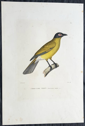
1824 Louis Freycinet Antique Print of Yellow Bellied Wood Shrike of Timor, 1818
- Title : Choucari Vert; (Graucalus Viridis)
- Ref #: 31742
- Size: 18in x 12in (460mm x 305mm)
- Date : 1824
- Condition: (A) Very Good Condition
Description:
This magnificent large hand coloured original copper-plate engraved antique print of The Yellow Bellied Wood Shrike of Timor (Plate no. 21) by Florent Prévost (visited by Freycinet in November 1818) was engraved by Jean-Louis-Denis Coutant (1776-1831) and published in the 1824 1st edition of Louis De Freycinets Atlas of Mammals, Birds etc Voyage autour du monde fait par ordre du Roi sur les corvettes de S. M. l\'Uranie et la Physicienne, pendant les années 1817, 1818, 1819 et 1820
These magnificent large hand coloured 1st edition engravings are extremely scarce and a must for ny collection.
Florent Prévost (1794 – 1870) was a French naturalist and illustrator. He was assistant naturalist at the Muséum National d Histoire Naturelle. He was the author of various zoological works, including Les Pigeons par Madame Knip (1843) and, with C. L. Lemaire, Histoire Naturelle des Oiseaux d\'Europe (1845). He did illustrative work in books by Coenraad Jacob Temminck (1778–1858), Charles Lucien Bonaparte (1803–1857) and Georges-Louis Leclerc de Buffon (1707–1788).
He worked on the birds from the voyage of La Venus with Marc Athanese Parfait Oeillet Des Murs, and on the birds and mammals brought back from the French expedition to Abyssinia between 1839 and 1843.
Prevost\'s ground sparrow (Melozone biarcuatum), Prevost\'s squirrel (Callosciurus prevostii), and Gerard\'s water snake (Gerarda prevostiana) are named after him
General Definitions:
Paper thickness and quality: - Heavy and stable
Paper color : - off white
Age of map color: - Original
Colors used: - Yellow, green, blue, pink
General color appearance: - Authentic
Paper size: - 18in x 12in (460mm x 305mm)
Plate size: - 13in x 9 ½in (330mm x 240mm)
Margins: - Min 2in (50mm)
Imperfections:
Margins: - Light soiling & spotting
Plate area: - None
Verso: - Light soiling & spotting
Background:
After the Restoration the French government gave Freycinet, then a captain, command of another expedition to circumnavigate the globe and conduct research into the shape of the earth, meteorology and terrestrial magnetism. He sailed from Toulon on 17 September 1817 in L Uranie with his wife Rose who secreted herself aboard, and who wrote a separate account of the voyage. After refreshing at the Cape of Good Hope and Mauritius he landed at Shark Bay, Western Australia on 12 September 1818 where he set up an observatory, thoroughly surveyed the inlets and the coastal districts and removed the plate left by Willem de Vlamingh, which he had found and re-erected in 1801. He then sailed north to Timor. His accounts and description of the landscape and life and customs of that and other islands in the East Indies captivated the attention of people in Europe much more than his Australian reports, and a widespread interest developed in the expedition. Leaving Timor on 27 November he sailed via the Moluccas, the Carolines, the Marianas, and the Sandwich Islands and reached Port Jackson on 19 November 1819, the scientists on board adding constantly to their store of information on hydrography, botany, cartography and anthropology. After spending Christmas ashore, they sailed on 26 December and, falling in with the westerlies, set a course for Cape Horn.
On 13 February 1820 L Uranie was wrecked on the Falkland Islands; the scientific records and notes were saved before the vessel foundered, but 2500 of the 4175 plant specimens were lost. Freycinet returned to France in November 1820 and died on 18 August 1842.
There is no evidence in the expedition\'s records or French governmental archives to suggest that there were political objectives in this circumnavigation but, though its purpose was to engage in scientific discovery, this first major voyage undertaken by the restored Bourbons did show the French flag in distant seas and foreshadowed a series of other expeditions which were not wholly scientific.