
Cooks Voyages (6)
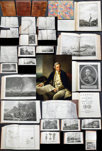
1774, 1777 & 1785 Capt James Cook 3 Atlas Volumes 1st Editions 204 Maps & Prints
- Title : 1. Figure du Banks 2. Premier Voyage De Cook 3. Troisieme Voyage De Cook
- Ref #: 93498, 93499, 93500
- Size: 4to (Quatro)
- Date : 1774; 1777; 1785
- Condition: (A+) Fine Condition
Description:
A unique and rare opportunity to acquire all three of Captain James Cooks 1st French edition Atlases (4to, Quatro), published to accompany the publication of his 3 voyages of discovery in 1774, 1777 & 1785. The atlases contain a total of 204 large folding, double page and single page maps and prints. It is very rare to find all three atlases complete and available together at the same time.
The contents of all three atlases are in fine condition, with a fresh, heavy impression and clean paper of all maps and prints.
As stated there are 204 maps and prints 51 in the 1st volume, 66 in the second volume and 87 in the second volume. Please view the images above, that include a few images of the 204 maps and prints as well as an itemized list of each volume.
General Definitions:
Paper thickness and quality: - Heavy and stable
Paper color : - off white
Age of map color: -
Colors used: -
General color appearance: -
Paper size: - 4to (Quatro)
Plate size: - 4to (Quatro)
Margins: - 4to (Quatro)
Imperfections:
Margins: - Some scuffing and wear to boards & spines
Plate area: - None
Verso: - None
Background:
Timeline First Voyage 1768 - 1771:
In 1768 Cook was chosen to lead an expedition to the South Seas to observe the Transit of Venus and to secretly search for the unknown Great Southern Continent (terra australis incognita).
Cook and his crew of nearly 100 men left Plymouth (August 1768) in the Endeavour and travelled via Madeira (September), Rio de Janiero (November-December) and Tierra del Fuego (January 1769) to Tahiti.
At Tierra del Fuego (January 1769) Cooks men went ashore and met the local people whom Cook thought perhaps as miserable a set of People as are this day upon Earth. Joseph Bankss party collected botanical specimens but his two servants, Thomas Richmond and George Dorlton, died of exposure in the snow and cold. Leaving Tierra del Fuego Endeavour rounded Cape Horn and sailed into the Pacific Ocean.
Sir Joseph Banks wrote about the homes of the Fuegans
..…huts or wigwams of the most unartificial construction imaginable, indeed no thing bearing the name of a hut could possibly be built with less trouble. They consisted of a few poles set up and meeting together at the top in a conical figure, these were covered on the weather side with a few boughs and a little grass, on the lee side about one eighth part of the circle was left open and against this opening was a fire made.......(Banks, Journal I, 224, 20th January 1769)
Samuel Wallis on the ship Dolphin discovered Tahiti in 1767. He recommended the island for the Transit of Venus observations and Cook arrived here in April 1769. Cook, like Wallis two years before him, anchored his ship in the shelter of Matavai Bay on the western side of the island.
In Matavai Bay Cook established a fortified base, Fort Venus, from which he was to complete his first task – the observation of the Transit of Venus (3rd June 1769). The fort also served as protection for all the important scientific and other equipment which had to be taken ashore as:
.......great and small chiefs and common men are firmly of opinion that if they can once get possession of an thing it immediately becomes their own…the chiefs employd in stealing what they could in the cabbin while their dependents took every thing that was loose about the ship…...(Joseph Banks).
Theft by some native peoples plagued Cooks voyages.
Cook and his crew experienced good relations with the Tahitians and returned to the islands on many occasions, attracted by the friendly people of this earthly paradise. On arrival Cook had set out the rules, including:
.....To endeavour by every fair means to cultivate a friendship with the Natives and to treat them with all imaginable humanity....
Just as Cook was planning to leave Tahiti two members of Endeavours crew decided to desert, having strongly attached themselves to two girls, but Cook recovered them.
Cook sailed around the neighbouring Society Islands and took on board the Tahitian priest, Tupaia, and his servant, Taiata. Endeavour left the Society Island in August 1769.
Tupaia acted as interpreter when they came into contact with other Polynesian peoples and helped Cook to make a map of the Pacific islands. This showed Cook the location of islands arranged according to their distance from Tahiti and indicated Tupaias and Polynesian knowledge of navigation and their skill as great mariners.
Cook sailed in search of the Southern Continent (August-October 1769) before turning west to New Zealand. The first encounters with the native Maori of New Zealand in October were violent, their warriors performing fierce dances, or hakas, in attempts to threaten and challenge the ships crew. Some of their warriors were killed when Cooks men had to defend themselves. Eventually relations improved and Cook was able to trade with the Maori for fresh supplies.
Exploring different bays and rivers along the way Cook circumnavigated New Zealand and was the first to accurately chart the whole of the coastline. He discovered that New Zealand consisted of two main islands, north (Te Ika a Maui) and south (Te Wai Pounamu) islands (October 1769-March 1770).
The artist Sydney Parkinson described three Maori who visited the Endeavour on 12th October 1769:
......Most of them had their hair tied up on the crown of their heads in a knot…Their faces were tataowed, or marked either all over, or on one side, in a very curious manner, some of them in fine spiral directions…
This Maori wears an ornamental comb, feathers in a top-knot, long pendants from his ears and a heitiki, or good luck amulet, around his neck.
At the northern end of the south island Cook anchored the ship in Ship Cove, Queen Charlotte Sound, which became a favourite stopping place on the following voyages. Parkinson noted:
......The manner in which the natives of this bay (Queen Charlotte Sound) catch their fish is as follows: - They have a cylindrical net, extended by several hoops at the bottom, and contracted at the top; within the net they stick some pieces of fish, then let it down from the side of the canoe and the fish, going in to feed, are caught with great ease.....(Parkinson, Journal, 114)
In Queen Charlottes Sound Cook visited one of the many Maori hippah, or fortified towns.
........The town was situated on a small rock divided from the main by a breach in a rock so small that a man might almost Jump over it; the sides were every where so steep as to render fortifications iven in their way almost totally useless, according there was nothing but a slight Palisade…in one part we observed a kind of wooden cross ornamented with feathers made exactly in the form of a crucifix cross…we were told that it was a monument to a dead man.......
Endeavour left New Zealand and sailed along the east coast of New Holland, or Australia, heading north (April-August 1770). Cook started to chart the east coast and on 29th April landed for the first time in what Cook called Stingray, later, Botany Bay.
The ship struck the Great Barrier Reef and was badly damaged (10 June). Repairs had to be carried out in Endeavour River. (June-August 1770). The first kangaroo to be sighted was recorded and shot.
The inhabitants of New Holland were very different from the people Cook had come across in other Pacific lands. They were darker skinned than the Maori and painted their bodies:
......They were all of them clean limnd, active and nimble. Cloaths they had none, not the least rag, those parts which nature willingly conceals being exposed to view compleatly uncovered......(Joseph Banks)
Tupaia could not make himself understood and at first the aborigines were very wary of the visitors and not at all interested in trading.
Joseph Banks recorded the fishing party observed at Botany Bay on 26 April 1770. He wrote:
......Their canoes… a piece of Bark tied together in Pleats at the ends and kept extended in the middle by small bows of wood was the whole embarkation, which carried one or two…people…paddling with paddles about 18 inches long, one of which they held in either hand.....(Banks, Journal II, 134)
Endeavour left Australia and sailed via the Possession Isle and Endeavour Strait for repairs at Batavia, Java (October-December 1770). Although the crew had been quite healthy and almost free from scurvy, the scourge of sailors, many caught dysentery and typhoid and over thirty died at Batavia or on the return journey home via Cape Town, South Africa (March-April 1771). The ship arrived off Kent, England (July 1771).
The voyage successfully recorded the Transit of Venus and largely discredited the belief in a Southern Continent. Cook charted the islands of New Zealand and the east coast of Australia and the scientists and artists made unique records of the peoples, flora and fauna of the different lands visited.
Timeline - Second Voyage 1772 - 1775
In July 1772 Resolution, commanded by Captain Cook, and Discovery, commanded by Lieutenant Furneaux, set sail from Britain, via Madiera (Jul-Aug) and Cape Town, South Africa (Oct-Nov), towards the Antarctic in search of the Great Southern Continent.
During January 1773 the ships took on fresh water, charts of the voyage being marked with:
......Here we watered our Ship with Ice the 1st. Time 26S 44W and Here we compleated our Water/26S 20W but became separated in thick fog: Here we parted company…. and The Resolutions Track after we parted Company on the 8 of February 1773......
The ships became the first known to have crossed the Antarctic Circle (17 January 1773). On 9th January Cook wrote:
.......we hoisted out three Boats and took up as much as yielded about 15 Tons of Fresh Water, the Adventure at the same time got about 8 or 9 and all this was done in 5 or 6 hours time; the pieces we took up and which had broke from the Main Island, were very hard and solid, and some of them too large to be handled so that we were obliged to break them with our Ice Azes before they could be taken into the Boats...... Cook, Journals II, 74.)
The ships met again in New Zealand (February-May 1773) and set off to explore the central Pacific, calling at Tahiti (August), where, from the island of Raiatea, they took aboard Omai who returned with the Adventure to England (7 September).
After visiting Amsterdam and Middelburg, two islands that Cook called the Friendly Islands (Tongan group) (October) the ships became separated and never met again. Both ships returned separately to New Zealand. (November) A boats crew from the Adventure were killed by Maori (17 December) and the ship sailed for Britain, arriving July 1774.
Cook on Resolution attempted another search for the Great Southern Continent (November 1773), crossing the Antarctic Circle on 20th December 1773. However, the ice and cold soon forced him to turn north again and he made another search in the central Pacific for the Great Southern Continent. In January 1774 he turned south again, crossing the Antarctic Circle for the second time. Captain Cooks Journal, 2nd January 1774.
Cook sailed north, arriving at Easter Island in March 1774. Cook was too ill to go ashore but a small party explored the southern part of the island. The artist William Hodges painted a group of the large statues of heads (moia) for which the island has become famous.
Cook then sailed to the Marquesas (March); Tahiti (April) and Raiatea (June); past the Cook Islands and Niue, or Savage Islands as Cook called them; Tonga (June); Vatoa, the only Fijian Island visited by Cook (July); New Hebrides (July-August); New Caledonia (September) and Norfolk Island (October); before returning to New Zealand (October 1774).
Not all the peoples of the islands visited by Cook were friendly and when his ship approached Niue the local people would not let his crew ashore. Cook wrote:
.......The Conduct and aspect of these Islanders occasioned my giving it the Name of Savage Island, it lies in the Latitude of 19 degrees 1 Longitude 169 degrees 37 West, is about 11 Leagues in circuit, of a tolerable height and seemingly covered with wood amongst which were some Cocoa-nutt trees......(Cook, Journals II, 435, 22 June 1774.)
En route for New Zealand, Cook sailed west and explored the islands which he called the New Hebrides, now known as Vanuatu, arriving on 17 July 1774. The people were Melanesian, not Polynesian, and spoke different languages and had different customs. Cook recorded:
........The Men go naked, it can hardly be said they cover their Natural parts, the Testicles are quite exposed, but they wrap a piece of cloth or leafe round the yard (nautical slang for the penis) which they tye up to the belly to a cord or bandage which they wear round the waist just under the Short ribs and over the belly and so tight that it was a wonder to us how they could endure it.......(Cook, Journals II, 464, 23 July 1774)
Cook sailed past or visited nearly all the islands in the group, including landfalls at Malekula, Tanna and Erromango. He later moved on to New Caledonia.
Cooks reception by the New Hebrideans was generally hostile. At Erromango during the landing on 4th August 1774 the marines had to open fire when the natives tried to seize the boat and started to fire missiles. Cook wrote:
....…I was very loath to fire upon such a Multitude and resolved to make the chief a lone fall a Victim to his own treachery…happy for many of these poor people not half our Musquets would go of otherwise many more must have fallen.......(Cook, Journals II, 479, 4th August 1774)
Some of Cooks crew were slightly injured but several natives were wounded and their leader killed. Back on the ship Cook had a gun fired to frighten off the islanders and decided to depart.
Cook left New Zealand to return to Britain via the Southern Ocean in November 1774 and arrived in Tierra del Fuego, South America, in December. Cook took on stores and spent the holiday in what he called Christmas Sound. He described the area:......except those little tufts of shrubbery, the whole country was a barren Tack (or Rock) doomed by Nature to everlasting sterility......(Cook, Ms Journal PRO Adm 55/108)
Cook left South America in early January 1775 and set off across the southern Atlantic for Cape Town, South Africa. On the way he tried to confirm the location of a number of islands charted by Alexander Dalrymple on an earlier voyage. On 17 January 1775 Cook arrived at the cold, bleak, glaciated island he called South Georgia and spent 3 days charting it before sailing on.
Cook headed east and in late January came across the South Sandwich Islands that he again charted and then sailed on to Cape Town, arriving in late March 1775. He then headed across the Atlantic via St. Helena and Ascension Island (May), the Azores (July) and landed at Portsmouth on 30th July 1775.
On his return Cook became a national hero. He was presented to the King, made a member of the Royal Society and received its Copley Medal for achievement. Cook was promoted to post-captain of Greenwich Hospital and wrote up his account of the voyage. This did not mean retirement for Cook who went on his third and final voyage the following year.
The second voyage was one of the greatest journeys of all time. During the three years the ships crews had remained healthy and only four of the Resolutions crew had died. Cook disproved the idea of the Great Southern Continent; had become the first recorded explorer to cross the Antarctic Circle; and had charted many Pacific islands for the first time.
Timeline - Third Voyage 1776 - 1780
In 1776 Cook sailed in a repaired Resolution (July) to search for the North West Passage and to return Omai to his home on Huahine in the Society Islands.
He sailed via the Canary Islands and was joined at Cape Town, South Africa, by the Discovery, commanded by Charles Clerke.
The Discovery was the smallest of Cooks ships and was manned by a crew of sixty-nine. The two ships were repaired and restocked with a large number of livestock and set off together for New Zealand ( December).
Cook sailed across the South Indian Ocean and confirmed the location of Desolation Island, later known as Kerguelen Island. Cook wrote of Christmas Harbour where he first anchored on 25th December 1776:
........I found the shore in a manner covered with Penguins and other birds and Seals…so fearless that we killed as ma(n)y as we chose for the sake of their fat or blubber to make Oil for our lamps and other uses… Here I displayd the British flag and named the harbour Christmas harbour as we entered it on that Festival........(Cook, Journals III, i, 29-32)
Cook sailed east, arriving at Van Diemens Land/Tasmania (January 1777) and Queen Charlottes Sound, New Zealand (February). The Maori were wary at first, expecting Cook to take revenge for the killing of members of the Adventures crew in 1773, but instead Cook befriended the leader of the attack.
The ships stayed for nearly two weeks in New Zealand, restocking with wild celery and scurvy grass and trading with the local Maori who set up a small village in Ship Cove. Cook set off around the islands of the south Pacific (February), visiting the Cook Islands (April); Tongan Islands (July); and Tahiti (August-December 1777)
In 1778 Cook visited the Hawaiian islands, or Sandwich Islands as he named them, for the first time. Cook wrote:
........We no sooner landed, that a trade was set on foot for hogs and potatoes, which the people gave us in exchange for nails and pieces of iron formed into some thing like chisels….At sun set I brought every body on board, having got during the day Nine tons of water….about sixty or eighty Pigs, a few Fowls, a quantity of potatoes and a few plantains and Tara roots.......(Cook, Journals III, i. 269 & 272)
In February 1778 Cook sailed from the Hawaiian Islands across the north Pacific to the Oregan coast of North America. He travelled up the coast in bad weather until he found a safe harbour, Nootka Sound, Vancouver Island, Canada. There he refitted the ships, explored the area and developed relations with the local people.
Cook described a village there, probably Yoquot:
….their houses or dwellings are situated close to the shore…Some of these buildings are raised on the side of a bank, theses have a flooring consisting of logs supported by post fixed in the ground….before these houses they make a platform about four feet broad…..so allows of a passage along the front of the building: They assend to this passage (along the front of the building) by steps, not unlike some at our landing places in the River Thames........(Cook, Journals III, i, 306)
Cook left Nootka Sound in April 1778 and sailed north along the Alaskan coast looking for inlets that might lead to the Northwest passage but was then forced to turn south. By July he had rounded the Alaskan Peninsula and was able to sail north again, visiting the Chukotskiy Peninsula, Russia, before heading out into the Bering Sea.
Cook described the summer huts, or yarangas, of the Chukchi people as:
.........pretty large, and circular and brought to a point at the top; the framing was of slight poles and bone, covered with the skins of Sea animals…About the habitations were erected several stages ten or twelve feet high, such as we had observed on some part of the American coast, they were built wholly of bones and seemed to be intended to dry skins, fish &ca. upon, out of reach of their dogs........(Cook, Journals III, I, 413)
After entering the Bering Sea on 11th August 1778, Cook crossed the Arctic Circle and went as far north as latitude 70 degrees 41 North before being forced back by the pack ice off Icy Cape, Alaska. On the ice all around the ships were large numbers of walruses. About a dozen of these huge animals were killed to replenish the supplies of fresh meat and to provide oil for the lamps.
Cook had to turn west and worked his way down the Russian coast, eventually heading south and east into Norton Sound, Alaska, in September 1778. He wrote of their very brief encounter with the inhabitants of Norton Sound:
....…a family of the Natives came near to the place where we were taking off wood…I saw no more than a Man, his wife and child…...(Cook, Journals III, I, 438)
After a short period spent searching for the Northwest Passage Cook realised that it was too late in the year to make any progress and so sailed for warmer winter quarters in the Hawaiian Islands, arriving there in December 1778.
After circumnavigating the big island of Hawaii for over a month the ships finally anchored in Kealakekua Bay on 16th January 1779. The Hawaiians in over 1000 canoes came out to welcome them, the arrival of the ships coinciding with celebrations to mark the religious festival of Makahiki to the god Lono. The Hawaiians seem to have treated Cook as a personification of the god and at first relations were good on this second visit. However, relationships became strained and Cook left the island on 4th February 1779.
When Cook left Hawaii his ships ran into gales which broke a mast, forcing him to return to Kealakekua Bay for repairs on 11th February. This time the native people were less friendly and stole the cutter of the Discovery. The next day, the 14th February 1779, Cook went ashore to take the Hawaiian king into custody pending the return of the cutter but a fight developed and Cook, four of his marines and a number of natives were killed. Cooks remains were buried at sea in Kealakekua Bay.
Charles Clerke took over command of the stunned expedition and explored the other Hawaiian islands before sailing north to search for the North-West Passage. The ships called at Kamchatka, Russia, (April-June) where they were welcomed by the governor, Behm, at Bolsheretsk. Behm took news of the expedition and Cooks death overland to St. Petersburg from where it reached Europe and Britain.
Having made another voyage into the Arctic in search of the Northwest Passage (June-July) the ships returned to Kamchatka in August. In November they set off sailing south along the east coast of Japan, between Taiwan and the Phillipines and arrived at Macao, China, in December.
In January 1780 the expeditions left for home, crossing the Indian Ocean, calling at Cape Town (April-May) and arriving back in Stromness, Orkney, in August but not returning to London until October 1780.
News of Cooks death reached Britain in January 1780, ahead of the return of Resolution and Discovery in October 1780. The voyage was written up and published and Cooks life gradually commemorated in articles, books, medals and monuments.
The achievements of the voyage were overshadowed by the deaths of both Cook and his second-in-command, Clerke. The main purpose of the voyage, the discovery of the Northwest Passage, was not realised but large tracts of the Pacific and Arctic coasts of America and Russia were charted.
Early attempts to summarise the life of Cook appeared in the popular press soon after news of his death reached Britain. Articles in journals such as the Westminster Magazine, published in January 1780, included Biographical Anecdotes of Capt. Cook, charting his life from his birth in Marton, North Yorkshire. The first published biography of Cook, Life of Captain James Cook, by Andrew Kippis, appeared a few years later in 1788.
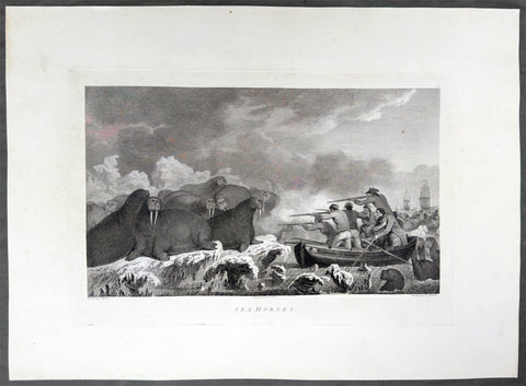
1784 James Cook & John Webber Antique 1st Edition Print Hunting Walrus Arctic Circle, 1778
Antique Print
- Title : Sea Horses
- Ref : 61270
- Size: 21 3/4in x 15 1/2in (550mm x 395mm)
- Date : 1784
- Condition: (A+) Fine Condition
Description:
This scarce first-edition large antique print, plate #52, the only plate engraved of The Arctic region, north of the Bering Straits, in August 1778, of Walruses, commonly called at the time Sea Horses, was drawn by John Webber (Cooks official onboard artist) and expertly engraved by Edmund Scott for the official, British Admiralty-sanctioned account of Cooks journey: "A Voyage to the Pacific Ocean... In Three Volumes. Vol. I & II and Atlas, written by James Cook & Capt J Clerk, F.R.S. Vol. III in London, 1784.
Cook's "Sea Horses" were walruses, which his crews met on the pack ice in the Arctic, north of the Bering Strait, in August 1778. The ships were short of fresh food, and on 19 August, a little south of Icy Cape at about 70° to 71°N, a huge number of walruses were seen lying on the ice. Cook sent two boats to hunt them, and by seven that evening seven had been brought aboard the Resolution. Further hunts took place on 27 and 28 August, and the ships shot more walrus in July 1779, during their second stay in the ice. The crews were divided about the taste of the meat, and Cook found the animals less dangerous than authors had claimed, more fearsome in appearance than in reality. He also complained that he had never seen a good drawing of one, and could not see why they were called sea horses, since they looked like a much larger seal. Webber took care to draw the walrus from several angles, and made several versions of the scene, which became plate 52 in the atlas. A large painting of it was shown at the Royal Academy in 1784.
Exceptional and highly sought-after large museum quality prints, perfect for collectors of Captain Cook history, maritime art, and early Australian, Pacific & Polar exploration.
General Definitions:
Paper thickness and quality: - Heavy and stable
Paper color : - off white
Age of map color: -
Colors used: -
General color appearance: -
Paper size: - 21 3/4in x 15 3/4in (550mm x 395mm)
Plate size: - 15 3/46in x 10in (400mm x 255mm)
Margins: - Min 2in (50mm)
Imperfections:
Margins: - None
Plate area: - None
Verso: - None
Background:
Captain James Cook's third and final voyage (1776–1780) set out from Plymouth to search for a Northwest Passage between the Pacific and Atlantic, sailing via the Cape of Good Hope and the Kerguelen Islands before visiting Tasmania and New Zealand and threading through the Pacific islands — Tonga, Tahiti, and the Society Islands — over the course of 1777. In January 1778 Cook became the first European to reach the Hawaiian Islands, which he named the Sandwich Islands, and from there sailed to the west coast of North America, charting the coastline from Oregon up through Nootka Sound, Unalaska (Alaska), and the Bering Strait into the Arctic Ocean, where pack ice forced him to turn back in August 1778. He wintered in Hawaii, anchoring at Kealakekua Bay in January 1779, where a dispute with islanders turned violent and Cook was killed on 14 February 1779. Command passed to Charles Clerke, who made one more unsuccessful attempt at the Northwest Passage before the expedition sailed home via Kamchatka Peninsula (Russia) , Macau, and the Cape of Good Hope, finally reaching England in October 1780.
Captain James Cook's third and final voyage A Voyage to the Pacific Ocean... In Three Volumes. Vol. I & II and Atlas, was illustrated in the original 1784/5 atlas containing 2 maps and 61 prints, engraved after John Webber's drawings (Cooks official artist on the voyage) by various engravers. Below is each location visited by Cook and later Capt. Clerk with the dates and corresponding prints.
Kerguelen Islands (Christmas Harbour) — 25 December 1776
• Plate 4 — A View of Christmas Harbour, in Kerguelen's Land
Van Diemen's Land (Tasmania), Adventure Bay — January 1777
• Plate 6 — A man of Van Diemen's Land
• Plate 7 — A woman of Van Diemen's Land
• Plate 8 — An opossum of Van Diemen's Land
Queen Charlotte Sound, New Zealand — February 1777
• Plate 10 — The Inside of a Hippah in New Zeeland
Mangaia, Cook Islands — March–April 1777
• Plate 11 — A man of Mangea
Tongan (Friendly) Islands — April–July 1777
• Plate 13 — A view at Anamooka
• Plate 14 — The reception of Captain Cook, in Hapaee
• Plate 15 — A boxing match, in Hapaee
• Plate 16 — A night dance by men, in Hapaee
• Plate 17 — A night dance by women, in Hapaee
• Plate 18 — Poulaho, King of the Friendly Islands
• Plate 20 — Poulaho, King of the Friendly Islands, drinking kava
• Plate 21 — A Fiatooka (Morai), in Tongataboo
• Plate 22 — The Natche, a ceremony in Tongataboo
• Plate 23 — A woman of Eaoo
Tahiti (Otaheite) — August 1777
• Plate 25 — A human sacrifice, in a marai
• Plate 26 — The body of Tee, a chief, as preserved after death
• Plate 27 — A young woman of Otaheite, bringing a present
• Plate 28 — A dance in Otaheite
• Plate 29 — A young woman of Otaheite, dancing
Huahine, Society Islands — October–November 1777
• Plate 31 — A view of Huaheine
Christmas Island (Kiritimati) — December 1777
• Discovered on this leg of the voyage; not separately plated
Kauai (Atooi), Hawaiian Islands — January 1778 (first European landfall in Hawaii) • Plate 33 — A Morai, in Atooi
• Plate34 — The inside of the house, in the Morai
• Plate 35 — An inland view, in Atooi
Nootka Sound, Vancouver Island — March–April 1778
• Plate 38 — A man of Nootka Sound
• Plate 39 — A woman of Nootka Sound
• Plate 40 — Various articles, at Nootka Sound
• Plate 41 — A view of the habitation in Nootka Sound
• Plate 42 — The inside of a house in Nootka Sound
• Plate 43 — A sea otter
Prince William Sound, Alaska — May 1778
• Plate 45 — A view of Snug Corner, in Prince William Sound
• Plate 46 — A man of Prince William Sound
• Plate 47 — A woman of Prince William Sound
Unalaska (Oonalashka) — June and October 1778
• Plate 48 — A man of Oonalashka
• Plate 49 — A woman of Oonalashka
• Plate 50 — Canoes of Oonalashka
• Plate 56 — Caps of the natives of Oonalashka
• Plate 57 — Natives of Oonalashka, and their habitations
• Plate 58 — The inside of a house, in Oonalashka
Norton Sound and the Chukchi Coast, Siberia — August 1778
• Plate 51 — The Tschuktschi, and their habitations
• Plate 54 — Inhabitants of Norton Sound and their habitations
Arctic Ocean, near the Bering Strait — August 1778 (Cook turned back by ice)
• Plate 52 — Sea horses (walruses)
Kealakekua Bay, Hawaii (Owyhee) — January–February 1779 (Cook killed 14 February 1779)
• Plate 60 — An offering before Captain Cook, in the Sandwich Islands
• Plate 61 — Tereoboo, King of Owyhee, bringing presents to Captain Cook
• Plate 62 — A man of the Sandwich Islands, dancing
• Plate 63 — A young woman of the Sandwich Islands
• Plate 64 — A man of the Sandwich Islands, with his helmet
• Plate 65 — A canoe of the Sandwich Islands, the rowers masked
• Plate 66 — A man of the Sandwich Islands, in a mask
• Plate 67 — Various articles, at the Sandwich Islands
• Plate 68 — A view of Karakakooa, in Owyhee
Kamchatka, St Peter and St Paul Harbour (Petropavlovsk) — spring and summer 1779
• Plate 70 — A man of Kamtschatka, travelling in winter
• Plate 71 — A sledge of Kamtschatka
• Plate 72 — A view at Bolcheretzkoi, in Kamtschatka
• Plate 73 — A white bear
• Plate 74 — A view of the town and harbour of St Peter and St Paul
• Plate 75 — A man of Kamtschatka
• Plate 76 — A woman of Kamtschatka
• Plate 77 — Summer and winter habitations, in Kamtschatka
• Plate 78 — The inside of a winter habitation in Kamtschatka
Return to England — October 1780
John Webber (1751–1793) was a Swiss-born British artist who served as the official expedition artist on Cook's third voyage, tasked with visually documenting the peoples, landscapes, and events the ships encountered. His drawings — later engraved as the 61 plates in the atlas accompanying the 1784 official account — provided some of the first detailed European depictions of Hawaii, the Pacific Northwest coast, and other Pacific and Arctic locales, including the scene of Cook's death at Kealakekua Bay. Webber was elected a full Royal Academician in 1791 and continued to exhibit landscape work until his death in 1793.
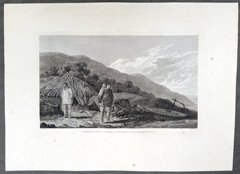
1784 James Cook & John Webber Antique 1st Edition Print Village of Norton Sound, Alaska 1778
Antique Print
- Title : Inhabitants of Norton Sound and their Habitations
- Ref : 61271
- Size: 21 3/4in x 15 3/4in (550mm x 395mm)
- Date : 1784
- Condition: (A) Very Good Condition
Description:
This scarce first-edition large antique print, plate #54, the only plate of Norton Sound in the Bering Straits, Alaska a view of a village & its inhabitants in September 1778, was drawn by John Webber (Cooks official onboard artist) and expertly engraved by Benjamin Thomas Pouncy for the official, British Admiralty-sanctioned account of Cooks journey: "A Voyage to the Pacific Ocean... In Three Volumes. Vol. I & II and Atlas, written by James Cook & Capt J Clerk, F.R.S. Vol. III in London, 1784.
In the summer of 1778, Cook's search for the Northwest Passage took him to both sides of the Bering Strait. He landed on the Chukotski Peninsula in Siberia on 10 August and met the Chukchi, who welcomed his party, and the two sides traded European knives, beads and tobacco for Chukchi clothes, gloves and arrows. Though the visit lasted only a few hours, Webber sketched their clothing, dogs and dome-shaped summer huts, and these became the plate "The Tschuktschi, and their Habitations".
The ships then passed north through the strait on 11 August. Pack ice stopped them off Alaska on 18 August, at about 70°N, and Cook spent the next eleven days working westward along the ice edge before reaching the Siberian coast again on 29 August. He gave up the search then and sailed south through the strait on 2 September. Turning to the Alaskan side, he explored the inlet he named Norton Sound after Sir Fletcher Norton, Speaker of the House of Commons, naming Cape Denbigh on 11 September and Besborough Island on 12 September. Like the Siberian coast, it offered no way through, since Norton Sound proved a shallow gulf and not a passage. Webber's plate of a family with their shelter and kayak is the main record of the people there. Cook then sailed for Unalaska and, after repairs, south to Hawaii for the winter.
Exceptional and highly sought-after large museum quality prints, perfect for collectors of Captain Cook history, maritime art, and early Australian, Pacific & Polar exploration.
General Definitions:
Paper thickness and quality: - Heavy and stable
Paper color : - off white
Age of map color: -
Colors used: -
General color appearance: -
Paper size: - 21 3/4in x 15 3/4in (550mm x 395mm)
Plate size: - 15 3/46in x 10in (400mm x 255mm)
Margins: - Min 2in (50mm)
Imperfections:
Margins: - Light creasing
Plate area: - Light creasing
Verso: - Light creasing
Background:
Captain James Cook's third and final voyage (1776–1780) set out from Plymouth to search for a Northwest Passage between the Pacific and Atlantic, sailing via the Cape of Good Hope and the Kerguelen Islands before visiting Tasmania and New Zealand and threading through the Pacific islands — Tonga, Tahiti, and the Society Islands — over the course of 1777. In January 1778 Cook became the first European to reach the Hawaiian Islands, which he named the Sandwich Islands, and from there sailed to the west coast of North America, charting the coastline from Oregon up through Nootka Sound, Unalaska (Alaska), and the Bering Strait into the Arctic Ocean, where pack ice forced him to turn back in August 1778. He wintered in Hawaii, anchoring at Kealakekua Bay in January 1779, where a dispute with islanders turned violent and Cook was killed on 14 February 1779. Command passed to Charles Clerke, who made one more unsuccessful attempt at the Northwest Passage before the expedition sailed home via Kamchatka Peninsula (Russia) , Macau, and the Cape of Good Hope, finally reaching England in October 1780.
Captain James Cook's third and final voyage A Voyage to the Pacific Ocean... In Three Volumes. Vol. I & II and Atlas, was illustrated in the original 1784/5 atlas containing 2 maps and 61 prints, engraved after John Webber's drawings (Cooks official artist on the voyage) by various engravers. Below is each location visited by Cook and later Capt. Clerk with the dates and corresponding prints.
Kerguelen Islands (Christmas Harbour) — 25 December 1776
• Plate 4 — A View of Christmas Harbour, in Kerguelen's Land
Van Diemen's Land (Tasmania), Adventure Bay — January 1777
• Plate 6 — A man of Van Diemen's Land
• Plate 7 — A woman of Van Diemen's Land
• Plate 8 — An opossum of Van Diemen's Land
Queen Charlotte Sound, New Zealand — February 1777
• Plate 10 — The Inside of a Hippah in New Zeeland
Mangaia, Cook Islands — March–April 1777
• Plate 11 — A man of Mangea
Tongan (Friendly) Islands — April–July 1777
• Plate 13 — A view at Anamooka
• Plate 14 — The reception of Captain Cook, in Hapaee
• Plate 15 — A boxing match, in Hapaee
• Plate 16 — A night dance by men, in Hapaee
• Plate 17 — A night dance by women, in Hapaee
• Plate 18 — Poulaho, King of the Friendly Islands
• Plate 20 — Poulaho, King of the Friendly Islands, drinking kava
• Plate 21 — A Fiatooka (Morai), in Tongataboo
• Plate 22 — The Natche, a ceremony in Tongataboo
• Plate 23 — A woman of Eaoo
Tahiti (Otaheite) — August 1777
• Plate 25 — A human sacrifice, in a marai
• Plate 26 — The body of Tee, a chief, as preserved after death
• Plate 27 — A young woman of Otaheite, bringing a present
• Plate 28 — A dance in Otaheite
• Plate 29 — A young woman of Otaheite, dancing
Huahine, Society Islands — October–November 1777
• Plate 31 — A view of Huaheine
Christmas Island (Kiritimati) — December 1777
• Discovered on this leg of the voyage; not separately plated
Kauai (Atooi), Hawaiian Islands — January 1778 (first European landfall in Hawaii) • Plate 33 — A Morai, in Atooi
• Plate34 — The inside of the house, in the Morai
• Plate 35 — An inland view, in Atooi
Nootka Sound, Vancouver Island — March–April 1778
• Plate 38 — A man of Nootka Sound
• Plate 39 — A woman of Nootka Sound
• Plate 40 — Various articles, at Nootka Sound
• Plate 41 — A view of the habitation in Nootka Sound
• Plate 42 — The inside of a house in Nootka Sound
• Plate 43 — A sea otter
Prince William Sound, Alaska — May 1778
• Plate 45 — A view of Snug Corner, in Prince William Sound
• Plate 46 — A man of Prince William Sound
• Plate 47 — A woman of Prince William Sound
Unalaska (Oonalashka) — June and October 1778
• Plate 48 — A man of Oonalashka
• Plate 49 — A woman of Oonalashka
• Plate 50 — Canoes of Oonalashka
• Plate 56 — Caps of the natives of Oonalashka
• Plate 57 — Natives of Oonalashka, and their habitations
• Plate 58 — The inside of a house, in Oonalashka
Norton Sound and the Chukchi Coast, Siberia — August 1778
• Plate 51 — The Tschuktschi, and their habitations
• Plate 54 — Inhabitants of Norton Sound and their habitations
Arctic Ocean, near the Bering Strait — August 1778 (Cook turned back by ice)
• Plate 52 — Sea horses (walruses)
Kealakekua Bay, Hawaii (Owyhee) — January–February 1779 (Cook killed 14 February 1779)
• Plate 60 — An offering before Captain Cook, in the Sandwich Islands
• Plate 61 — Tereoboo, King of Owyhee, bringing presents to Captain Cook
• Plate 62 — A man of the Sandwich Islands, dancing
• Plate 63 — A young woman of the Sandwich Islands
• Plate 64 — A man of the Sandwich Islands, with his helmet
• Plate 65 — A canoe of the Sandwich Islands, the rowers masked
• Plate 66 — A man of the Sandwich Islands, in a mask
• Plate 67 — Various articles, at the Sandwich Islands
• Plate 68 — A view of Karakakooa, in Owyhee
Kamchatka, St Peter and St Paul Harbour (Petropavlovsk) — spring and summer 1779
• Plate 70 — A man of Kamtschatka, travelling in winter
• Plate 71 — A sledge of Kamtschatka
• Plate 72 — A view at Bolcheretzkoi, in Kamtschatka
• Plate 73 — A white bear
• Plate 74 — A view of the town and harbour of St Peter and St Paul
• Plate 75 — A man of Kamtschatka
• Plate 76 — A woman of Kamtschatka
• Plate 77 — Summer and winter habitations, in Kamtschatka
• Plate 78 — The inside of a winter habitation in Kamtschatka
Return to England — October 1780
John Webber (1751–1793) was a Swiss-born British artist who served as the official expedition artist on Cook's third voyage, tasked with visually documenting the peoples, landscapes, and events the ships encountered. His drawings — later engraved as the 61 plates in the atlas accompanying the 1784 official account — provided some of the first detailed European depictions of Hawaii, the Pacific Northwest coast, and other Pacific and Arctic locales, including the scene of Cook's death at Kealakekua Bay. Webber was elected a full Royal Academician in 1791 and continued to exhibit landscape work until his death in 1793.
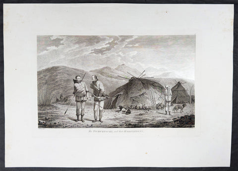
1784 James Cook & John Webber Antique 1st Edition Print Village in Chukotski Peninsula, Siberia , 1778
Antique Print
- Title : The Tschuktschi, and their Habitations
- Ref : 61228
- Size: 21 3/4in x 15 1/2in (550mm x 395mm)
- Date : 1784
- Condition: (A) Very Good Condition
Description:
This scarce first-edition large antique print, plate #51, the only plate illustrating the Chukotski Peninsula in Siberia, of a view of a Chukotski Village & its inhabitants in August 1778, was drawn by John Webber (Cooks official onboard artist) and expertly engraved by Daniel Lerpiniere for the official, British Admiralty-sanctioned account of Cooks journey: "A Voyage to the Pacific Ocean... In Three Volumes. Vol. I & II and Atlas, written by James Cook & Capt J Clerk, F.R.S. Vol. III in London, 1784.
In the summer of 1778, Cook's search for the Northwest Passage took him to both sides of the Bering Strait. He landed on the Chukotski Peninsula in Siberia on 10 August and met the Chukchi, who welcomed his party, and the two sides traded European knives, beads and tobacco for Chukchi clothes, gloves and arrows. Though the visit lasted only a few hours, Webber sketched their clothing, dogs and dome-shaped summer huts, and these became the plate "The Tschuktschi, and their Habitations".
The ships then passed north through the strait on 11 August. Pack ice stopped them off Alaska on 18 August, at about 70°N, and Cook spent the next eleven days working westward along the ice edge before reaching the Siberian coast again on 29 August. He gave up the search then and sailed south through the strait on 2 September. Turning to the Alaskan side, he explored the inlet he named Norton Sound after Sir Fletcher Norton, Speaker of the House of Commons, naming Cape Denbigh on 11 September and Besborough Island on 12 September. Like the Siberian coast, it offered no way through, since Norton Sound proved a shallow gulf and not a passage. Webber's plate of a family with their shelter and kayak is the main record of the people there. Cook then sailed for Unalaska and, after repairs, south to Hawaii for the winter.
Exceptional and highly sought-after large museum quality prints, perfect for collectors of Captain Cook history, maritime art, and early Australian, Pacific & Polar exploration.
General Definitions:
Paper thickness and quality: - Heavy and stable
Paper color : - off white
Age of map color: -
Colors used: -
General color appearance: -
Paper size: - 21 3/4in x 15 1/2in (550mm x 395mm)
Plate size: - 16in x 10in (405mm x 255mm)
Margins: - Min 2in (50mm)
Imperfections:
Margins: - Light creasing
Plate area: - Light creasing
Verso: - Light creasing
Background:
Captain James Cook's third and final voyage (1776–1780) set out from Plymouth to search for a Northwest Passage between the Pacific and Atlantic, sailing via the Cape of Good Hope and the Kerguelen Islands before visiting Tasmania and New Zealand and threading through the Pacific islands — Tonga, Tahiti, and the Society Islands — over the course of 1777. In January 1778 Cook became the first European to reach the Hawaiian Islands, which he named the Sandwich Islands, and from there sailed to the west coast of North America, charting the coastline from Oregon up through Nootka Sound, Unalaska (Alaska), and the Bering Strait into the Arctic Ocean, where pack ice forced him to turn back in August 1778. He wintered in Hawaii, anchoring at Kealakekua Bay in January 1779, where a dispute with islanders turned violent and Cook was killed on 14 February 1779. Command passed to Charles Clerke, who made one more unsuccessful attempt at the Northwest Passage before the expedition sailed home via Kamchatka Peninsula (Russia) , Macau, and the Cape of Good Hope, finally reaching England in October 1780.
Captain James Cook's third and final voyage A Voyage to the Pacific Ocean... In Three Volumes. Vol. I & II and Atlas, was illustrated in the original 1784/5 atlas containing 2 maps and 61 prints, engraved after John Webber's drawings (Cooks official artist on the voyage) by various engravers. Below is each location visited by Cook and later Capt. Clerk with the dates and corresponding prints.
Kerguelen Islands (Christmas Harbour) — 25 December 1776
• Plate 4 — A View of Christmas Harbour, in Kerguelen's Land
Van Diemen's Land (Tasmania), Adventure Bay — January 1777
• Plate 6 — A man of Van Diemen's Land
• Plate 7 — A woman of Van Diemen's Land
• Plate 8 — An opossum of Van Diemen's Land
Queen Charlotte Sound, New Zealand — February 1777
• Plate 10 — The Inside of a Hippah in New Zeeland
Mangaia, Cook Islands — March–April 1777
• Plate 11 — A man of Mangea
Tongan (Friendly) Islands — April–July 1777
• Plate 13 — A view at Anamooka
• Plate 14 — The reception of Captain Cook, in Hapaee
• Plate 15 — A boxing match, in Hapaee
• Plate 16 — A night dance by men, in Hapaee
• Plate 17 — A night dance by women, in Hapaee
• Plate 18 — Poulaho, King of the Friendly Islands
• Plate 20 — Poulaho, King of the Friendly Islands, drinking kava
• Plate 21 — A Fiatooka (Morai), in Tongataboo
• Plate 22 — The Natche, a ceremony in Tongataboo
• Plate 23 — A woman of Eaoo
Tahiti (Otaheite) — August 1777
• Plate 25 — A human sacrifice, in a marai
• Plate 26 — The body of Tee, a chief, as preserved after death
• Plate 27 — A young woman of Otaheite, bringing a present
• Plate 28 — A dance in Otaheite
• Plate 29 — A young woman of Otaheite, dancing
Huahine, Society Islands — October–November 1777
• Plate 31 — A view of Huaheine
Christmas Island (Kiritimati) — December 1777
• Discovered on this leg of the voyage; not separately plated
Kauai (Atooi), Hawaiian Islands — January 1778 (first European landfall in Hawaii) • Plate 33 — A Morai, in Atooi
• Plate34 — The inside of the house, in the Morai
• Plate 35 — An inland view, in Atooi
Nootka Sound, Vancouver Island — March–April 1778
• Plate 38 — A man of Nootka Sound
• Plate 39 — A woman of Nootka Sound
• Plate 40 — Various articles, at Nootka Sound
• Plate 41 — A view of the habitation in Nootka Sound
• Plate 42 — The inside of a house in Nootka Sound
• Plate 43 — A sea otter
Prince William Sound, Alaska — May 1778
• Plate 45 — A view of Snug Corner, in Prince William Sound
• Plate 46 — A man of Prince William Sound
• Plate 47 — A woman of Prince William Sound
Unalaska (Oonalashka) — June and October 1778
• Plate 48 — A man of Oonalashka
• Plate 49 — A woman of Oonalashka
• Plate 50 — Canoes of Oonalashka
• Plate 56 — Caps of the natives of Oonalashka
• Plate 57 — Natives of Oonalashka, and their habitations
• Plate 58 — The inside of a house, in Oonalashka
Norton Sound and the Chukchi Coast, Siberia — August 1778
• Plate 51 — The Tschuktschi, and their habitations
• Plate 54 — Inhabitants of Norton Sound and their habitations
Arctic Ocean, near the Bering Strait — August 1778 (Cook turned back by ice)
• Plate 52 — Sea horses (walruses)
Kealakekua Bay, Hawaii (Owyhee) — January–February 1779 (Cook killed 14 February 1779)
• Plate 60 — An offering before Captain Cook, in the Sandwich Islands
• Plate 61 — Tereoboo, King of Owyhee, bringing presents to Captain Cook
• Plate 62 — A man of the Sandwich Islands, dancing
• Plate 63 — A young woman of the Sandwich Islands
• Plate 64 — A man of the Sandwich Islands, with his helmet
• Plate 65 — A canoe of the Sandwich Islands, the rowers masked
• Plate 66 — A man of the Sandwich Islands, in a mask
• Plate 67 — Various articles, at the Sandwich Islands
• Plate 68 — A view of Karakakooa, in Owyhee
Kamchatka, St Peter and St Paul Harbour (Petropavlovsk) — spring and summer 1779
• Plate 70 — A man of Kamtschatka, travelling in winter
• Plate 71 — A sledge of Kamtschatka
• Plate 72 — A view at Bolcheretzkoi, in Kamtschatka
• Plate 73 — A white bear
• Plate 74 — A view of the town and harbour of St Peter and St Paul
• Plate 75 — A man of Kamtschatka
• Plate 76 — A woman of Kamtschatka
• Plate 77 — Summer and winter habitations, in Kamtschatka
• Plate 78 — The inside of a winter habitation in Kamtschatka
Return to England — October 1780
John Webber (1751–1793) was a Swiss-born British artist who served as the official expedition artist on Cook's third voyage, tasked with visually documenting the peoples, landscapes, and events the ships encountered. His drawings — later engraved as the 61 plates in the atlas accompanying the 1784 official account — provided some of the first detailed European depictions of Hawaii, the Pacific Northwest coast, and other Pacific and Arctic locales, including the scene of Cook's death at Kealakekua Bay. Webber was elected a full Royal Academician in 1791 and continued to exhibit landscape work until his death in 1793.
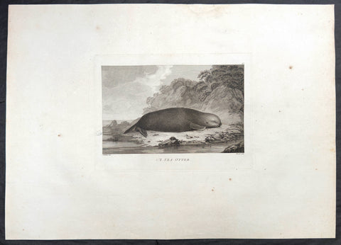
1784 James Cook & John Webber Antique 1st Edition Print Sea Otter, Nootka Sound Vancouver Is. Canada, 1778
Antique Print
- Title : A Sea Otter
- Ref : 61224
- Size: 20 3/4in x 15 1/2in (525mm x 395mm)
- Date : 1784
- Condition: (A) Very Good Condition
Description:
This scarce first-edition large antique print, plate #43, the sixth plate engraved of Nootka Sound and its inhabitants, of a Sea Otter in Nootka Sound Vancouver Island Canada in April 1778, whose fur was much prized by Cook and crew for clothes and later trade during their voyage looking for the NW passage, was drawn by John Webber (Cooks official onboard artist) and expertly engraved by Paul Mazell for the official, British Admiralty-sanctioned account of Cooks journey: "A Voyage to the Pacific Ocean... In Three Volumes. Vol. I & II and Atlas, written by James Cook & Capt J Clerk, F.R.S. Vol. III in London, 1784.
Cook's ships Resolution and Discovery reached the American Northwest Coast in late March 1778 and anchored in Ship Cove, in the sound Cook named King George's Sound. It later became known as Nootka Sound, a name that came from a misunderstanding of what the local people said. The ships stayed from 29 March to 26 April, mainly to repair rigging and replace masts and spars, and this was the first sustained contact between Europeans and the Nuu-chah-nulth people of the region. The Nuu-chah-nulth came out in canoes to trade, and Cook's crews bought many sea otter pelts and other furs in exchange for iron, brass and other metal goods. The men used the skins as warm bedding and clothing. The expedition's artist, John Webber, drew the people, their houses and carvings, and the animals of the coast, including the sea otter. He and Cook visited the village of Yuquot on 22 April. Cook did not yet understand how valuable the pelts were. After his death in Hawaii in 1779, the expedition reached Canton in China, where the furs sold for very high prices, and some of the crew wanted to go straight back for more. The published account of the voyage in 1784 spread the news, and Nootka Sound became the starting point of the maritime fur trade.
Exceptional and highly sought-after large museum quality prints, perfect for collectors of Captain Cook history, maritime art, and early Australian, Pacific & Polar exploration.
General Definitions:
Paper thickness and quality: - Heavy and stable
Paper color : - off white
Age of map color: -
Colors used: -
General color appearance: -
Paper size: - 20 3/4in x 15 1/2in (525mm x 395mm)
Plate size: - 10 1/2in x 7 3/4in (265mm x 195mm)
Margins: - Min 2in (50mm)
Imperfections:
Margins: - Light creasing
Plate area: - Light creasing
Verso: - Light creasing
Background:
Captain James Cook's third and final voyage (1776–1780) set out from Plymouth to search for a Northwest Passage between the Pacific and Atlantic, sailing via the Cape of Good Hope and the Kerguelen Islands before visiting Tasmania and New Zealand and threading through the Pacific islands — Tonga, Tahiti, and the Society Islands — over the course of 1777. In January 1778 Cook became the first European to reach the Hawaiian Islands, which he named the Sandwich Islands, and from there sailed to the west coast of North America, charting the coastline from Oregon up through Nootka Sound, Unalaska (Alaska), and the Bering Strait into the Arctic Ocean, where pack ice forced him to turn back in August 1778. He wintered in Hawaii, anchoring at Kealakekua Bay in January 1779, where a dispute with islanders turned violent and Cook was killed on 14 February 1779. Command passed to Charles Clerke, who made one more unsuccessful attempt at the Northwest Passage before the expedition sailed home via Kamchatka Peninsula (Russia) , Macau, and the Cape of Good Hope, finally reaching England in October 1780.
Captain James Cook's third and final voyage A Voyage to the Pacific Ocean... In Three Volumes. Vol. I & II and Atlas, was illustrated in the original 1784/5 atlas containing 2 maps and 61 prints, engraved after John Webber's drawings (Cooks official artist on the voyage) by various engravers. Below is each location visited by Cook and later Capt. Clerk with the dates and corresponding prints.
Kerguelen Islands (Christmas Harbour) — 25 December 1776
• Plate 4 — A View of Christmas Harbour, in Kerguelen's Land
Van Diemen's Land (Tasmania), Adventure Bay — January 1777
• Plate 6 — A man of Van Diemen's Land
• Plate 7 — A woman of Van Diemen's Land
• Plate 8 — An opossum of Van Diemen's Land
Queen Charlotte Sound, New Zealand — February 1777
• Plate 10 — The Inside of a Hippah in New Zeeland
Mangaia, Cook Islands — March–April 1777
• Plate 11 — A man of Mangea
Tongan (Friendly) Islands — April–July 1777
• Plate 13 — A view at Anamooka
• Plate 14 — The reception of Captain Cook, in Hapaee
• Plate 15 — A boxing match, in Hapaee
• Plate 16 — A night dance by men, in Hapaee
• Plate 17 — A night dance by women, in Hapaee
• Plate 18 — Poulaho, King of the Friendly Islands
• Plate 20 — Poulaho, King of the Friendly Islands, drinking kava
• Plate 21 — A Fiatooka (Morai), in Tongataboo
• Plate 22 — The Natche, a ceremony in Tongataboo
• Plate 23 — A woman of Eaoo
Tahiti (Otaheite) — August 1777
• Plate 25 — A human sacrifice, in a marai
• Plate 26 — The body of Tee, a chief, as preserved after death
• Plate 27 — A young woman of Otaheite, bringing a present
• Plate 28 — A dance in Otaheite
• Plate 29 — A young woman of Otaheite, dancing
Huahine, Society Islands — October–November 1777
• Plate 31 — A view of Huaheine
Christmas Island (Kiritimati) — December 1777
• Discovered on this leg of the voyage; not separately plated
Kauai (Atooi), Hawaiian Islands — January 1778 (first European landfall in Hawaii) • Plate 33 — A Morai, in Atooi
• Plate34 — The inside of the house, in the Morai
• Plate 35 — An inland view, in Atooi
Nootka Sound, Vancouver Island — March–April 1778
• Plate 38 — A man of Nootka Sound
• Plate 39 — A woman of Nootka Sound
• Plate 40 — Various articles, at Nootka Sound
• Plate 41 — A view of the habitation in Nootka Sound
• Plate 42 — The inside of a house in Nootka Sound
• Plate 43 — A sea otter
Prince William Sound, Alaska — May 1778
• Plate 45 — A view of Snug Corner, in Prince William Sound
• Plate 46 — A man of Prince William Sound
• Plate 47 — A woman of Prince William Sound
Unalaska (Oonalashka) — June and October 1778
• Plate 48 — A man of Oonalashka
• Plate 49 — A woman of Oonalashka
• Plate 50 — Canoes of Oonalashka
• Plate 56 — Caps of the natives of Oonalashka
• Plate 57 — Natives of Oonalashka, and their habitations
• Plate 58 — The inside of a house, in Oonalashka
Norton Sound and the Chukchi Coast, Siberia — August 1778
• Plate 51 — The Tschuktschi, and their habitations
• Plate 54 — Inhabitants of Norton Sound and their habitations
Arctic Ocean, near the Bering Strait — August 1778 (Cook turned back by ice)
• Plate 52 — Sea horses (walruses)
Kealakekua Bay, Hawaii (Owyhee) — January–February 1779 (Cook killed 14 February 1779)
• Plate 60 — An offering before Captain Cook, in the Sandwich Islands
• Plate 61 — Tereoboo, King of Owyhee, bringing presents to Captain Cook
• Plate 62 — A man of the Sandwich Islands, dancing
• Plate 63 — A young woman of the Sandwich Islands
• Plate 64 — A man of the Sandwich Islands, with his helmet
• Plate 65 — A canoe of the Sandwich Islands, the rowers masked
• Plate 66 — A man of the Sandwich Islands, in a mask
• Plate 67 — Various articles, at the Sandwich Islands
• Plate 68 — A view of Karakakooa, in Owyhee
Kamchatka, St Peter and St Paul Harbour (Petropavlovsk) — spring and summer 1779
• Plate 70 — A man of Kamtschatka, travelling in winter
• Plate 71 — A sledge of Kamtschatka
• Plate 72 — A view at Bolcheretzkoi, in Kamtschatka
• Plate 73 — A white bear
• Plate 74 — A view of the town and harbour of St Peter and St Paul
• Plate 75 — A man of Kamtschatka
• Plate 76 — A woman of Kamtschatka
• Plate 77 — Summer and winter habitations, in Kamtschatka
• Plate 78 — The inside of a winter habitation in Kamtschatka
Return to England — October 1780
John Webber (1751–1793) was a Swiss-born British artist who served as the official expedition artist on Cook's third voyage, tasked with visually documenting the peoples, landscapes, and events the ships encountered. His drawings — later engraved as the 61 plates in the atlas accompanying the 1784 official account — provided some of the first detailed European depictions of Hawaii, the Pacific Northwest coast, and other Pacific and Arctic locales, including the scene of Cook's death at Kealakekua Bay. Webber was elected a full Royal Academician in 1791 and continued to exhibit landscape work until his death in 1793.
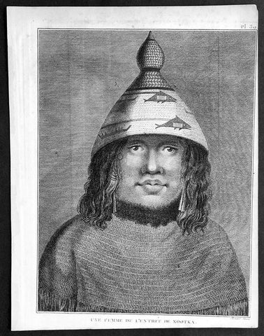
1785 Capt. Cook Antique Print Woman of Nootka Sound, Vancouver Isle Canada, 1778
- Title : Une Femme De L Entreee De Nootka
- Ref : 31768
- Size: 10in x 8in (255mm x 205mm)
- Date : 1785
- Condition: (A+) Fine Condition
Description:
This fine original copper-plate engraved antique print of a woman of Nootka Sound, on the West Coast of Vancouver Island, Canada, drawn during a visit by Captain Cook in 1778, during his 3rd and last Voyage of Discovery, was engraved by Robert Benard - after Cooks on-board artist, John Webber - and was published in the 1785 French edition of Capt. James Cook & Capt. James King A Voyage to the Pacific Ocean. Undertaken, by the Command of his Majesty, for making Discoveries in the Northern Hemisphere. To determine The Position and Extent of the West Side of North America; its Distance from Asia; and the Practicability of a Northen Passage to Europe. Performed under the direction of Captains Cook, Clerke, and Gore, In His Majesty\'s Ships the Resolution and Discovery. In the Years 1776, 1777, 1778, 1779, and 1780. In Three Volumes. Vol. I and II written by James Cook, F.R.S. Vol. III by Captain James King, LL.D. and F.R.S. Paris, 1785.
General Definitions:
Paper thickness and quality: - Heavy and stable
Paper color : - off white
Age of map color: -
Colors used: -
General color appearance: -
Paper size: - 10in x 8in (255mm x 205mm)
Plate size: - 9 1/2in x 7 1/4in (240mm x 185mm)
Margins: - Min 1/2in (12mm)
Imperfections:
Margins: - Light soiling in margins
Plate area: - None
Verso: - None
Background:
Nootka Sound is a sound of the Pacific Ocean, on the rugged west coast of Vancouver Island, in the Canadian province of British Columbia, historically known as King George\'s Sound. It separates Vancouver Island and Nootka Island.
On August 8, 1774, the Spanish Navy ship Santiago, under Juan Pérez, entered and anchored in the inlet. Although the Spanish did not land, natives paddled to the ship to trade furs for abalone shells from California. Pérez named the entrance to Nootka Sound Surgidero de San Lorenzo. The word surgidero means source. When Esteban José Martinez arrived in 1789 he gave Nootka Sound the name Puerto de San Lorenzo de Nuca. The Spanish establishment established at Friendly Cove he gave the name Santa Cruz de Nuca.
In March 1778, Captain James Cook of the Royal Navy landed on Bligh Island and named the inlet\"King George\'s Sound. He recorded that the native name was Nutka or Nootka, apparently misunderstanding his conversations at Friendly Cove/Yuquot; his informant may have been explaining that he was on an island (itchme nutka, a place you can go around). There may also have been confusion with Nuu-chah-nulth, the natives\' autonym (name for themselves). It may also have simply been based on Cook’s mis-pronunciation of Yuquot, the native name of the place. The earlier Spanish and British names for the Sound swiftly went out of use.
At the time, the Spanish monopolized the trade between Asia and North America, and had granted limited licenses to the Portuguese. The Russians had established a growing fur trading system in Alaska. The Spanish began to challenge the Russians, with Pérez\'s voyage being the first of many to the Pacific Northwest. The British also became increasingly active in the region.
The next European to visit Nootka Sound after James Cook was the British trader James Hanna in August 1785. Hanna traded iron bars for furs. He sold the furs in China for a handsome profit, beginning an era of the Maritime Fur Trade.
Captain James King FRS 1750 – 1784 was an officer of the Royal Navy. He served under James Cook on his last voyage around the world, specialising in taking important astronomical readings using a sextant. After Cook died he helped lead the ships on the remainder of their course, also completing Cook\\\'s account of the voyage. He continued his career in the Navy, reaching the rank of post-captain, commanding several ships and serving in the American War of Independence.
King joined HMS Resolution as second lieutenant, sharing the duties of astronomer with Cook, taking astronomical observations on board by sextant and with Larcum Kendals timekeeper K1, to establish the Resolutions position at sea and on shore by sextant or by astronomical quadrant to establish the geographical position of salient points during the course of Cooks surveys. Thus King\\\'s geographical positions were an important contribution to the accuracy of the various surveys carried out during the voyage and his use of the early chronometers helped prove their use at sea for calculation of Longitude. .
Following the death of Cook, King remained in the Resolution but on the death of Charles Clerke, Cooks successor, King was appointed to command HMS Discovery, the Resolution\\\'s consort, remaining in her for the rest of the voyage. After his return to England King was very much involved in the publication of the official account of Cooks third voyage, writing the third volume at Woodstock, near Oxford, where his brother Thomas was rector of St Mary Magdalene. But shortly after his return King was promoted Post-captain and appointed commander of HMS Crocodile in the English Channel.
John Webber RA 1751 – 1793 was an English artist who accompanied Captain Cook on his third Pacific expedition. He is best known for his images of Australasia, Hawaii and Alaska.
Webber was born in London, educated in Bern and studied painting at Paris.His father was Abraham Wäber, a Swiss sculptor who had moved to London, and changed his name to Webber before marrying a Mrs Mary Quant in 1744.
Webber served as official artist on James Cook\'s third voyage of discovery around the Pacific (1776–80) aboard HMS Resolution. At Adventure Bay in January 1777 he did drawings of A Man of Van Diemens Land and A Woman of Van Diemens Land. He also did many drawings of scenes in New Zealand and the South Sea islands. On this voyage, during which Cook lost his life in a fight in Hawaii, Webber became the first European artist to make contact with Hawaii, then called the Sandwich Islands. He made numerous watercolor landscapes of the islands of Kauai and Hawaii, and also portrayed many of the Hawaiian people.
In April 1778, Captain Cooks ships Resolution and Discovery anchored at Ship Cove, now known as Nootka Sound, Vancouver Island, Canada to refit. The crew took observations and recorded encounters with the local people. Webber made watercolour landscapes including Resolution and Discovery in Ship Cove, 1778. His drawings and paintings were engraved for British Admiraltys account of the expedition, which was published in 1784.
Back in England in 1780 Webber exhibited around 50 works at Royal Academy exhibitions between 1784 and 1792, and was elected an associate of the Royal Academy in 1785 and R.A. in 1791. Most of his work were landscapes. Sometimes figures were included as in A Party from H.M.S. Resolution shooting sea horses\", which was shown at the academy in 1784, and his The Death of Captain Cook became well known through an engraving of it. Another version of this picture is in the William Dixson gallery at Sydney
Robert Bénard 1734 – 1777 was an 18th-century French engraver.
Specialized in the technique of engraving, Robert Ménard is mainly famous for having supplied a significant amount of plates (at least 1,800) to the Encyclopédie by Diderot & d\'Alembert from 1751.
Later, publisher Charles-Joseph Panckoucke reused many of his productions to illustrate the works of his catalog.


