
Claude Ptolemy (150AD)
Background:
"Geographia," written by Claudius Ptolemy in the 2nd century AD, is a landmark work in the history of geography and cartography. The book is divided into eight volumes, with the first two providing an introduction and a discussion of map projection techniques. The remaining six volumes contain detailed descriptions of the geography of the known world, as well as instructions for constructing maps using Ptolemy's system of projections and coordinate systems.
One of the most important aspects of "Geographia" is Ptolemy's use of a system of latitude and longitude to create a grid of the earth's surface. This system allowed for the accurate plotting of locations and the creation of maps that accurately represented the earth's surface. Ptolemy's coordinate system was based on the division of the earth into 360 degrees of longitude and 180 degrees of latitude, with the equator serving as the starting point for measuring latitude and the meridian passing through Alexandria as the starting point for measuring longitude.
Another important contribution of "Geographia" is Ptolemy's use of map projections to create accurate maps of the earth's surface. Ptolemy used several different projections, including the conical projection and the cylindrical projection, which allowed for accurate depiction of different regions of the world.
The "Geographia" also contains a wealth of information about the known world at the time of Ptolemy's writing, including descriptions of major cities, rivers, mountain ranges, and other geographic features. Ptolemy's work was based on the work of earlier Greek geographers, as well as on his own observations and calculations.
While some of Ptolemy's measurements and calculations were later found to be inaccurate, "Geographia" remains an important work in the history of geography and cartography. His system of projections and coordinate systems were used by later cartographers, and his contributions to the field have been celebrated for centuries.
Re-discovery of the Ptolemy Texts:
In the early 15th century, a copy of "Geographia" was discovered in Constantinople (modern-day Istanbul) by the Byzantine scholar Maximus Planudes, who translated the work into Greek. This Greek translation became the basis for many later translations into European languages.
In the 16th century, the rediscovery of Ptolemy's texts played a major role in the development of cartography and geography. The Italian scholar and cartographer Giacomo Gastaldi published an Italian edition of "Geographia" in 1548, which was followed by a French edition by André Thevet in 1575. These editions included maps based on Ptolemy's system of projections and coordinate systems, which were highly accurate and widely used.
In the 17th century, the Dutch cartographer Willem Blaeu produced a highly influential edition of "Geographia" that included new maps and updated information about the known world. Blaeu's edition was widely used and highly regarded, and it helped to establish Ptolemy's work as a cornerstone of modern cartography.
Today, the "Geographia" remains an important work in the history of geography and cartography, and it continues to be studied and used by scholars and researchers around the world. The rediscovery of Ptolemy's texts played a key role in the development of modern cartography, and it is a testament to the enduring importance of classical knowledge and scholarship.
The first printed versions of Ptolemy’s Text:
The first modern printed edition of Ptolemy's "Geographia" was produced in Bologna, Italy, in 1477 by the printer and publisher Dominicus de Lapis. This edition, known as the "Bologna Ptolemy," was based on a manuscript that had been brought to Italy from Constantinople. It included maps based on Ptolemy's system of projections and coordinate systems, but also included updates and revisions based on new geographic and cartographic knowledge.
Other notable 15th and 16th century editions of Ptolemy's "Geographia" include:
-
-
"Geographia," Bologna edition (1477): This was the first printed edition of Ptolemy's "Geographia," produced by the printer Dominicus de Lapis in Bologna, Italy. It was based on a Greek manuscript brought from Constantinople, and included maps based on Ptolemy's system of projections and coordinate systems.
-
"Geographia," Rome edition (1478-79): This edition was produced by the printers Conrad Sweynheym and Arnold Buckinck in Rome, Italy. It was largely based on the Bologna edition, but included a number of corrections and improvements.
-
"Geographia," Ulm edition (1482): This edition was produced by Lienhart Holle in Ulm, Germany. It was the first edition to include woodcut maps, and is notable for its decorative woodcut borders.
-
"Geographia," Naples edition (1486): This edition was produced by Sixtus Riessinger in Naples, Italy. It included updated maps and information, as well as a new set of coordinates based on the Canary Islands.
-
"Geographia," Vicenza edition (1486): This edition was produced by Hermann Liechtenstein in Vicenza, Italy. It included woodcut maps based on the Bologna edition, as well as a number of corrections and improvements.
-
"Geographia," Rome edition (1490): This edition was produced by Johannes Andreas de Breda in Rome, Italy. It was largely based on the 1478-79 Rome edition, but included a number of new maps and updated information.
-
These editions, and others like them, played an important role in the development of modern geography and cartography. They helped to disseminate new geographic knowledge and advances in map-making techniques, and they helped to establish the importance of Ptolemy's work as a foundational text in the field.
After the initial printing of Ptolemy's "Geographia" in the 15th century, there were numerous later editions that were printed over the course of the following centuries. Some of the more notable editions include:
-
1511: The first printed edition of the "Geographia" in Greek was published in Venice. It was edited by Marcus Beneventanus and printed by Bernardinus de Vitalibus.
-
1522: Johannes Schott, a professor of mathematics in Strasbourg, published an edition of the "Geographia" with maps that were printed from woodblocks.
-
1533: Another edition of the "Geographia" was published in Venice, with updated maps based on the latest information available at the time.
-
1540: Sebastian Münster, a German cartographer, published a new edition of the "Geographia" in Basel. His edition included updated maps and commentary.
-
1578: The Dutch cartographer Abraham Ortelius published an edition of the "Geographia" with updated maps that were based on the latest discoveries of the time.
-
1597: Gerard Mercator, a famous Flemish cartographer, published an edition of the "Geographia" with updated maps that were based on his own observations and the latest discoveries of the time.
These later editions of the "Geographia" continued to be influential in the field of cartography and geography, and helped to disseminate Ptolemy's ideas and concepts to a wider audience.
Claude Ptolemy (2)

1486 Claude Ptolemy, Holle & Reger Antique Renaissance Map of Great Britain & Ireland - Rare
Antique Map
- Title : Prima Europe Tabula
- Date : 1486
- Size: 20 1/2in x 15 1/2in (552mm x 397mm)
- Condition: (A+) Fine Condition
- Ref: 92669
This original hand coloured wood-block engraved very early, rare antique map of Great Britain & Ireland was published in the 1486 Ulm edition & translation of Claudius Ptolemys (87-150) text, published in the 2nd edition of Lienhart Holles & by Johann Reger atlas Claudii Ptolomei .... Cosmographie ... Opus Donni Nicolai Germani Secvndvm Ptolomevm Finit, Ulm, Germany. (Shirley 5)
This is a unique & very rare map and only the 4th map of the British Isles printed, published only 47 years after Johannes Gutenbergs invention of the moveable type printing press in 1439.
The two edition of Lienhart Holles atlases were published in 1482 & 1486. The 1482 Ulm edition of Ptolemys Geographia was the first edition printed north of the Alps and the first to appear in color, applied by the publisher.
The 1482 Ulm edition was one of the most important cartographic texts of the early Renaissance and the first edition of the work to be printed outside Italy. The text for this edition was based upon a manuscript translated into Latin by Jacobus Angeli and edited by Nicolaus Germanus that had been brought to Ulm from Rome in 1468. The Ulm Ptolemy was published in 1482 by Lienhart Holle, the same year as Berlingheris Florence edition. Ashley Baynton Williams notes:.........Working independently of Berlinghieri, but apparently using the same or similar models, Holle also added modern maps of Spain, France, Italy and Palestine, but also the first printed map of Scandinavia, composed by Cornelius Clavus, circa 1425-7 . Holles maps were printed from woodcuts, and are characterised by heavy wash colouring for the sea areas, typically a rich blue for the 1482 edition, and an ochre for the 1486 edition. These bright colours, and the greater sense of age that woodcuts convey, make this series the most visually appealing of the Ptolemeic maps.........
Holle went bankrupt shortly after the original publication and the work was taken over by Johann Reger, who issued a second edition in 1486.
This large map is in fine condition on strong sturdy paper, the printing impression is heavy and clear. The colour is original and beautifully applied. There has been professional restoration to the L&R bottom corners. No loss of original paper and restrengthened on the verso. The centerfold has been re-strengthened, on the verso, with some light creasing and rippling.
General Condition:
Paper thickness and quality: - Heavy and stable
Paper color: - off white
Age of map color: - Original
Colors used: - Yellow, green, red, brown.
General color appearance: - Authentic and fresh
Paper size: - 20 1/2in x 15 1/2in (552mm x 397mm)
Image size: -14 1/2in x 14 1/2in x 20 1/4in (369mm x 369mm (upper margin) 511 mm (lower margin)
Margins: - Min 1/4in (6mm)
Imperfections:
Margins: - Light discolouration & soiling.
Plate area: - Bottom L&R corners restored, no loss. Light creasing and rippling
Verso: - Re-enforced along center-fold and L&R bottom corners
Background: The first editions of Ptolemys Geographia Atlas was published in Italy in 1477 and republished in 1478 & 1482. The next atlas to be published was north of the Alps by Lienhart Holle, in Ulm, Germany in 1482. Holles maps were printed from woodcuts, and are distinct with their heavy wash colouring for the sea areas, typically a rich blue for the 1482 edition, and an ochre for the 1486 edition. These bright colours, and the greater sense of age that woodcuts convey, make this series of maps one of the most visually attractive.
Claudius Ptolemy: (87-150) was an Egyptian astronomer and geographer living and studying in Alexandria. Alexandria was not only the home of the greatest library of any period, but was also one of the most important trade centres between west and east - here Ptolemy could not only study ancient authorities, but could also consult contemporary travellers and merchants. From this wealth of accumulated knowledge, Ptolemy composed his <i>Geographia</i>, a work of considerable genius, which dominated the whole of the Christian and Moslem world for 1,500 years (Tooley).
It was Ptolemy who introduced the concept of latitude and longitude to form a grid to cover the whole world, so that it would be possible to plot the position of principal land-marks on the map by observations, and then fill in other information from other sources, including the notes and Itinerary of Marinus of Tyre, perhaps the most accurate source available.
Unfortunately Ptolemy was hampered by the paucity of observations - as a result he exaggerated the length of the Mediterranean by over 20 degrees -and by lack of information which was often circumvented by invention. Despite these errors, which persisted for nearly 1,500 years, the work was of fundamental importance at a time when little was being done in the way of modern mapping. As a result of this work, which was so far in advance of anything before or anything produced in the next 1,500 years, Ptolemy has earned the reputation and accolade, the father of geography (Tooley).
Re-discovery of the Ptolemy Texts: Following the fall of the Roman Empire, Ptolemys text was lost to western geographers. The earliest extant manuscript version of the Geographia is Arabic, and probably dates from the 12th Century. Subsequently, the text was translated into Greek, and circulated through the Greek World. In about 1400 a Greek manuscript came into the hands of the Byzantine scholar, Emanuel Chrysolaras, who was working in Italy. Chrysolaras undertook a translation of the text into Latin, and completed by his pupil Jacopo dAngelo, in 1406. The Greek manuscript that Angelo translated was apparently lacking maps, but the data in the text contained the information to construct a set of maps, and numbers of scholars set about such work. Of them, the most influential, was Donnus Nicolaus Germanus, a German cartographer, active in Italy from the 1460s to 1480s. He was a prolific editor of the text and maps, and his work formed the basis for three of the four sets of Ptolemaic maps printed in the fifteenth Century, with the fourth, accompanying Berlinghieris Geographia, strongly influenced by him .
The first printed versions of Ptolemys Text: The first published edition of the Geographia with maps, which were probably engraved by Taddeo Crivelli, was issued in Bologna in 1477. Conrad Sweynheym was also working on an edition of Ptolemy in Rome in the same period. After his death, Arnold Buckinck, saw the atlas through the press, in 1478. Of the engraved editions of Ptolemys Cosmographia the maps in the Rome edition are the finest fifteenth century examples, and second only to Mercators maps, from his 1578 edition. The atlas proved popular, and three successive editions (to 1508) followed. In 1482, Nicolas Laurentii published a set of Ptolemaic maps to illustrate Francesco Berlinghieri Geographia.
The first edition of Ptolemys Geographia printed outside Italy was published by Lienhart Holle, in Ulm, also in 1482. Holles maps were printed from woodcuts, and are characterised by heavy wash colouring for the sea areas, typically a rich blue for the 1482 edition, and an ochre for the 1486 edition. These bright colours, and the greater sense of age that woodcuts convey, make this series the most visually appealing of these various sets of maps.
Later Editions of Ptolemy: Next in chronological sequence, and the most unusual of the editions of Ptolemy, was that published by Jacobus Pentius de Leucho in Venice in 1511, edited by Bernardus Sylvanus. Martin Waldseemullers edition of Ptolemy, first published in 1513, is the most important of the sixteenth century editions. Waldseemullers edition was reprinted in 1520, and then the maps were re-drawn by Lorenz Fries on a smaller format, for editions published in 1522, 1525, 1535 and 1541. The next to produce an edition of Ptolemy was Sebastian Munster, who worked in Basle. Munster was one of the leading geographers and cartographers of his period, and he diligently set about revising and improving the maps. Giacomo Gastaldi, one of the leading cartographers of the sixteenth century, composed a set of maps for an edition of the Geographia, published in Venice in 1548. Of all the editions of Ptolemy, that prepared by Gerard Mercator, and published in 1578, is technically the finest, with the World map being a particularly fine engraving. This atlas is, also, noteworthy for its longevity, the original printing plates were still in use in 1730, over one hundred and fifty years after they were first engraved. (Ref: Shirley 5; Stevenson; Tooley; M&B; MapForum)
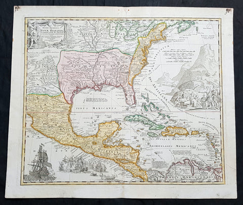
1712 J B Homann Large Antique 1st Edition Map of North & Central America
- Title : Regni Mexicani seu Novae Hispaniae Ludovicianae, N. Angliae, Carolinae, Virginiae, et Pensylvaniae nec non Insularum Archipelagi Mexicani in America Septentrionali accurata Tabula...Joh. Baptista Homano
- Ref #: 93464
- Size: 25in x 21 1/2in (635mm x 545mm)
- Date : 1712
- Condition: (A+) Fine Condition
Description:
This large, original beautifully hand coloured, copper plate engraved antique 1st edition map of North & Central America and The Caribbean was published by Johann Baptiste Homann in 1712.
This is a magnificent map, with all the political nuisances of early 18th century Europe played out on on a map of The New World.
The tension between the three European superpowers of the time, France, Spain & England, is evident from the diminishing power of the Spanish, to the aspirational power of the French and British. The French borders in Louisiana and Canada push west and south far beyond reality, encroaching into New Mexico, Canada & the British colonial states. Large Spanish warships are seen to overpower both the British & French fleets in the bottom left naval battle.
With the death of Queen Anne in 1714 and the ascension of George I to the British throne, the era of British power in the New World will lead to the inevitable hard fought freedom of a new country, the United States. A great early 18th century map.
General Definitions:
Paper thickness and quality: - Heavy and stable
Paper color : - off white
Age of map color: - Original
Colors used: - Yellow, green, blue, pink
General color appearance: - Authentic
Paper size: - 25in x 21 1/2in (635mm x 545mm)
Plate size: - 23in x 19 1/2in (590mm x 500mm)
Margins: - Min 1/2in (12mm)
Imperfections:
Margins: - Old ink notations top L & R corners not affecting image
Plate area: - None
Verso: - None
Background:
J B Homanns 1715 map of North & Central America from The Great Lakes to Mexico, The Caribbean to Panama was based on the earlier 1703 map of the same region by Claude Delisle, Carte du Mexique et de la Florida des Terres Angloises, who derived his information from the likes of La Salle, Bienville, d Iberville, Le Sueur and other French, British & Spanish explorers.
The map centres on Louisiana and the Mississippi River Valley, with detailed information of Mexico to the Pacific, north to New Mexico and the Great Lakes. East to the Colonial states, French Florida, The West Indies and northern South America.
Louisiana is divided as per the French borders in Delisles map, with large French aspirations extending well into Spanish North America from the Rio Grande to the Appalachian Mountains. France also lays claim to large sways of land in Canada and the whole of the Great Lakes and much of the northern colonial states of the time. One of the earliest maps to accurately portray the mouth of the Mississippi and the Great Lakes region.
An elaborately decorative map with illustrations of Spanish unloading gold while the native Americans look on. To the lower left is shown a large Spanish Galleon, with guns blazing on the smaller French or British fleet, highlighting the still evident power of the Spanish. A very political European view of the new world in the early 18th century.