City Plans (4)
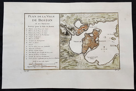
1756 J N Bellin Antique Map of The City of Boston & Charlestown
Antique Map
- Title : Plan de la Ville De Boston et ses Environs
- Ref #: 93417
- Size: 14 1/2in x 9 1/2in (350mm x 240mm)
- Date : 1756
- Condition: (A+) Fine Condition
Description:
This original hand coloured copper plate engraved antique map of Boston and surrounding areas - one of the earliest obtainable maps of the city - by Jacques Nicholas Bellin in 1756 - was published in the French edition of Antoine-François Prevosts 20 volume L Histoire Generale des Voyages published by Pierre de Hondt in the Hague between 1747 & 1785.
Beautiful map with great street and building detail in both Boston and Charlestown, showing parts of Ronde Isle and the mainland. Important buildings and areas identified in an idex at the left of the map. Including three cannon batteries, the Presbyterian Church, the Quaker temple, the Anabaptist Church, the City Hall, the Armory, Faneuil Hall (Spelled Fanal), etc. (Ref: Tooley; M&B)
General Definitions:
Paper thickness and quality: - Heavy and stable
Paper color : - off white
Age of map color: - Early
Colors used: - Yellow, green, blue, pink
General color appearance: - Authentic
Paper size: - 14 1/2in x 9 1/2in (350mm x 240mm)
Plate size: - 11 1/2in x 7 1/2in (285mm x 190mm)
Margins: - Min 1in (25mm)
Imperfections:
Margins: - None
Plate area: - Folds as issued
Verso: - None
Background:
Boston is the capital city and most populous municipality of the Commonwealth of Massachusetts in the United States.
Boston is one of the oldest cities in the United States, founded on the Shawmut Peninsula in 1630 by Puritan settlers from England. It was the scene of several key events of the American Revolution, such as the Boston Massacre, the Boston Tea Party, the Battle of Bunker Hill, and the Siege of Boston. Upon U.S. independence from Great Britain, it continued to be an important port and manufacturing hub as well as a center for education and culture.
In the 1820s, Boston\\\\\\\\\\\\\\\'s population grew rapidly, and the city\\\\\\\\\\\\\\\'s ethnic composition changed dramatically with the first wave of European immigrants. Irish immigrants dominated the first wave of newcomers during this period, especially following the Irish Potato Famine; by 1850, about 35,000 Irish lived in Boston. In the latter half of the 19th century, the city saw increasing numbers of Irish, Germans, Lebanese, Syrians, French Canadians, and Russian and Polish Jews settling in the city. By the end of the 19th century, Boston\\\\\\\\\\\\\\\'s core neighborhoods had become enclaves of ethnically distinct immigrants. Italians inhabited the North End, Irish dominated South Boston and Charlestown, and Russian Jews lived in the West End. Irish and Italian immigrants brought with them Roman Catholicism. Currently, Catholics make up Boston\\\\\\\\\\\\\\\'s largest religious community and the Irish have played a major role in Boston politics since the early 20th century; prominent figures include the Kennedys, Tip O\\\\\\\\\\\\\\\'Neill, and John F. Fitzgerald.
Between 1631 and 1890, the city tripled its area through land reclamation by filling in marshes, mud flats, and gaps between wharves along the waterfront. The largest reclamation efforts took place during the 19th century; beginning in 1807, the crown of Beacon Hill was used to fill in a 50-acre mill pond that later became the Haymarket Square area. The present-day State House sits atop this lowered Beacon Hill. Reclamation projects in the middle of the century created significant parts of the South End, the West End, the Financial District, and Chinatown.
After the Great Boston Fire of 1872, workers used building rubble as landfill along the downtown waterfront. During the mid- to-late 19th century, workers filled almost 600 acres of brackish Charles River marshlands west of Boston Common with gravel brought by rail from the hills of Needham Heights. The city annexed the adjacent towns of South Boston (1804), East Boston (1836), Roxbury (1868), Dorchester (including present day Mattapan and a portion of South Boston) (1870), Brighton (including present day Allston) (1874), West Roxbury (including present day Jamaica Plain and Roslindale) (1874), Charlestown (1874), and Hyde Park (1912). Other proposals were unsuccessful for the annexation of Brookline, Cambridge and Chelsea.
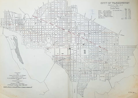
1880 F V Greene Large Antique Map Lines of Planted Trees in Washington DC
- Title : City of Washington Statistical Map No 4 showing the lines of Shade Trees.....Compiled by Lieut. F V Greene, US Engrs. Asst to the Engr. Commr. to accompany the annual report of the Commissioners of the District of Columbia for the year ending June 30th 1880
- Size: 30in x 23in (767mm x 585mm)
- Condition: (A) Very Good Condition
- Date : 1880
- Ref #: 16266
Description:
This large original lithograph map, a city plan of Washington DC, showing the lines of Trees planted very early in the cities growth, by Lieutenant Francis Vinton Greene, was published in June 1880, dated.
General Definitions:
Paper thickness and quality: - Heavy and stable
Paper color : - off white
Age of map color: - Original
Colors used: - Blue, pink, red, green, yellow
General color appearance: - Authentic
Paper size: - 30in x 23in (767mm x 585mm)
Plate size: - 30in x 23in (767mm x 585mm)
Margins: - Min 1/2in (12mm)
Imperfections:
Margins: - Light soiling L&R bottom corners
Plate area: - None
Verso: - Bottom L&R bottom corner backing canvas loose
Background:
The history of Washington, D.C. is tied to its role as the capital of the United States. Originally inhabited by an Algonquian-speaking people known as the Nacotchtank. the site of the District of Columbia along the Potomac River was first selected by President George Washington. The city came under attack during the War of 1812 in an episode known as the Burning of Washington. Upon the government\'s return to the capital, it had to manage reconstruction of numerous public buildings, including the White House and the United States Capitol.
By 1870, the District\'s population had grown 75% from the previous census to nearly 132,000 residents. Despite the citys growth, Washington still had dirt roads and lacked basic sanitation. The situation was so bad that some members of Congress suggested moving the capital further west, but President Ulysses S. Grant refused to consider such a proposal.
In response to the poor conditions in the capital, Congress passed the Organic Act of 1871, which revoked the individual charters of the cities of Washington and Georgetown, and created a new territorial government for the whole District of Columbia. The act provided for a governor appointed by the President, a legislative assembly with an upper-house composed of eleven appointed council members and a 22-member house of delegates elected by residents of the District, as well as an appointed Board of Public Works charged with modernizing the city.
President Grant appointed Alexander Robey Shepherd, an influential member of the Board of Public Works, to the post of governor in 1873. Shepherd authorized large-scale municipal projects, which greatly modernized Washington. However, the governor spent three times the money that had been budgeted for capital improvements and ultimately bankrupted the city. In 1874, Congress abolished the Districts territorial government and replaced it with a three-member Board of Commissioners appointed by the President, of which one was a representative from the United States Army Corps of Engineers. The three Commissioners would then elect one of themselves to be president of the commission.
An additional act of Congress in 1878 made the three-member Board of Commissioners the permanent government of the District of Columbia. The act also had the effect of eliminating any remaining local institutions such as the boards on schools, health, and police. The Commissioners would maintain this form of direct rule for nearly a century.
Greene, Francis Vinton 1850–1921
Greene was a United States Army officer who fought in the Spanish–American War. He came from the Greene family of Rhode Island, noted for its long line of participants in American military history.
Greene was born in Providence, Rhode Island on June 27, 1850. He attended the United States Military Academy at West Point and graduated in 1870. He first served in the U.S. artillery and then transferred to the Corps of Engineers in 1872. He next served as an attaché from the War Department to the U.S. legation in St. Petersburg, Russia. While there he served in the Russian army during its war with Turkey. He was promoted to first lieutenant in 1874 and captiain in 1883. He returned to the U.S. and was a civil engineer to the city of Washington, D.C. and was a professor of artillery at West Point before resigning from the Army on December 31, 1886.
When the Spanish–American War broke out he raised the 7th New York Volunteer Infantry and was commissoned as it colonel on May 2, 1898. He was quickly promoted to brigadier general of Volunteers on May 27, 1898. He commanded the second Philippine Expeditionary Force which became the 2nd Brigade, 2nd Division, VIII Corps. Greene took a prominent part in the Battle of Manila in 1898. He assisted in the surrender negotiations for Manila. In August 1898 he was promoted major general of Volunteers and resigned on February 28, 1899.
After the war, he pursued a variety of occupations. He was a delegate to the Republican National Convention in 1900. He served as the New York City Police Commissioner from 1903 to 1904. He was president of the Niagara-Lockport and Ontario Power Company, along with other business ventures with Buffalo businessman John J. Albright. He died on May 13, 1921 in New York City.
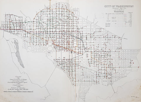
1880 F V Greene Large Antique Map Location of the Water Mains in Washington DC
- Title : City of Washington Statistical Map No 6 showing the lines of Water Mains...Compiled by Lieut. F V Greene, US Engrs. Asst to the Engr. Commr. to accompany the annual report of the Commissioners of the District of Columbia for the year ending June 30th 1880
- Size: 30in x 23in (767mm x 585mm)
- Condition: (A) Very Good Condition
- Date : 1880
- Ref #: 16263
Description:
This large original lithograph map, a city plan of Washington DC, showing the location of the Water Mains very early in the cities growth, by Lieutenant Francis Vinton Greene, was published in June 1880, dated.
General Definitions:
Paper thickness and quality: - Heavy and stable
Paper color : - off white
Age of map color: - Original
Colors used: - Blue, pink, red, green, yellow
General color appearance: - Authentic
Paper size: - 30in x 23in (767mm x 585mm)
Plate size: - 30in x 23in (767mm x 585mm)
Margins: - Min 1/2in (12mm)
Imperfections:
Margins: - Light soiling L&R bottom corners
Plate area: - None
Verso: - Bottom L&R bottom corner backing canvas loose
Background:
The history of Washington, D.C. is tied to its role as the capital of the United States. Originally inhabited by an Algonquian-speaking people known as the Nacotchtank. the site of the District of Columbia along the Potomac River was first selected by President George Washington. The city came under attack during the War of 1812 in an episode known as the Burning of Washington. Upon the government\'s return to the capital, it had to manage reconstruction of numerous public buildings, including the White House and the United States Capitol.
By 1870, the District\'s population had grown 75% from the previous census to nearly 132,000 residents. Despite the citys growth, Washington still had dirt roads and lacked basic sanitation. The situation was so bad that some members of Congress suggested moving the capital further west, but President Ulysses S. Grant refused to consider such a proposal.
In response to the poor conditions in the capital, Congress passed the Organic Act of 1871, which revoked the individual charters of the cities of Washington and Georgetown, and created a new territorial government for the whole District of Columbia. The act provided for a governor appointed by the President, a legislative assembly with an upper-house composed of eleven appointed council members and a 22-member house of delegates elected by residents of the District, as well as an appointed Board of Public Works charged with modernizing the city.
President Grant appointed Alexander Robey Shepherd, an influential member of the Board of Public Works, to the post of governor in 1873. Shepherd authorized large-scale municipal projects, which greatly modernized Washington. However, the governor spent three times the money that had been budgeted for capital improvements and ultimately bankrupted the city. In 1874, Congress abolished the Districts territorial government and replaced it with a three-member Board of Commissioners appointed by the President, of which one was a representative from the United States Army Corps of Engineers. The three Commissioners would then elect one of themselves to be president of the commission.
An additional act of Congress in 1878 made the three-member Board of Commissioners the permanent government of the District of Columbia. The act also had the effect of eliminating any remaining local institutions such as the boards on schools, health, and police. The Commissioners would maintain this form of direct rule for nearly a century.
Greene, Francis Vinton 1850–1921
Greene was a United States Army officer who fought in the Spanish–American War. He came from the Greene family of Rhode Island, noted for its long line of participants in American military history.
Greene was born in Providence, Rhode Island on June 27, 1850. He attended the United States Military Academy at West Point and graduated in 1870. He first served in the U.S. artillery and then transferred to the Corps of Engineers in 1872. He next served as an attaché from the War Department to the U.S. legation in St. Petersburg, Russia. While there he served in the Russian army during its war with Turkey. He was promoted to first lieutenant in 1874 and captiain in 1883. He returned to the U.S. and was a civil engineer to the city of Washington, D.C. and was a professor of artillery at West Point before resigning from the Army on December 31, 1886.
When the Spanish–American War broke out he raised the 7th New York Volunteer Infantry and was commissoned as it colonel on May 2, 1898. He was quickly promoted to brigadier general of Volunteers on May 27, 1898. He commanded the second Philippine Expeditionary Force which became the 2nd Brigade, 2nd Division, VIII Corps. Greene took a prominent part in the Battle of Manila in 1898. He assisted in the surrender negotiations for Manila. In August 1898 he was promoted major general of Volunteers and resigned on February 28, 1899.
After the war, he pursued a variety of occupations. He was a delegate to the Republican National Convention in 1900. He served as the New York City Police Commissioner from 1903 to 1904. He was president of the Niagara-Lockport and Ontario Power Company, along with other business ventures with Buffalo businessman John J. Albright. He died on May 13, 1921 in New York City.
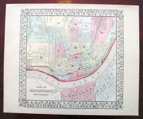
1869 Mitchell Antique Map - Plan of The City of Cincinnati
- Title : Plan of Cincinnati and Vicinity....1869 by S. Augustus Mitchell
- Ref #: 35044
- Size: 15in x 12in (380mm x 300mm)
- Date : 1870
- Condition: (A+) Fine Condition
Description:
This beautifully hand coloured original antique city plan map was published by Samuel Augustus Mitchell in the 1870 edition of his large New General Atlas - dated at the foot of the map.
These county, state, city & country maps are some of the most ornate and beautifully coloured maps published in the US in the 19th century. For over 50 years, Mitchell his son's and their successors were the most prominent cartographical publishers of maps and atlases in the United States.
General Description:
Paper thickness and quality: - Heavy & stable
Paper color: - White
Age of map color: - Original
Colors used: - Green, pink, yellow
General color appearance: - Authentic
Paper size: - 15in x 12in (380mm x 300mm)
Plate size: - 15in x 12in (380mm x 300mm)
Margins: - Min 1/2in (10mm)
Imperfections:
Margins: - None
Plate area: - None
Verso: - None