City Plans (1)
1575 Braun & Hogenberg Map of Pozzuoli Bay Naples Italy
Antique Map
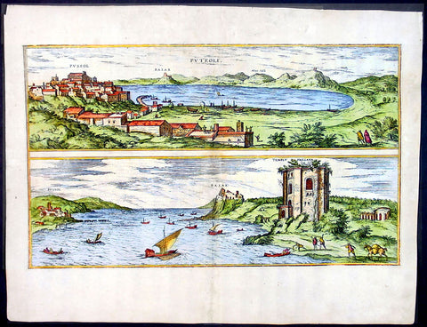
- Title : Puteoli et Baiae
- Date : 1575
- Condition: (A+) Fine Condition
- Ref: 92687
- Size: 21in x 16in (535mm x 410mm)
Description:
This finely engraved beautifully hand coloured original antique 2 x birds-eye view of the Bay of Pozzuoli -in the Gulf of Naples - with The city of Pozzuoli & the Port Of Baia visible was published by Georg Braun & Frans Hogenberg for the 1575 atlas of town plans Civiates Orbis Terrarum Vol II intended as a companion to Abraham Ortelius's master Atlas Theatrum Orbis Terrarum published in 1570.
The Gulf of Naples is a 10-mile wide gulf located in the south western coast of Italy, (province of Naples, Campania region). It opens to the west into the Mediterranean Sea & is bordered on the north by the cities of Naples and Pozzuoli. To the east is Mount Vesuvius, and on the south by the Sorrentine Peninsula and its main town Sorrento; the Peninsula separates it from the Gulf of Salerno.
Pozzuoli began as the Greek colony of Dicaearchia. The Roman colony was established in 194 BC, and took the Latin name Puteoli 'little wells', referring to the many hot springs in the area, most notably Solfatara. This is because Pozzuoli lies in the center of the Campi Flegrei, a caldera.
Puteoli was the great emporium for the Alexandrian grain ships, and other ships from all over the Roman world. It also was the main hub for goods exported from Campania, including blown glass, mosaics, wrought iron, and marble. The Roman naval base at nearby Misenum housed the largest naval fleet in the ancient world. It was also the site of the Roman Dictator Sulla's country villa and the place where he died in 78 BC.
The local volcanic sand, pozzolana formed the basis for the first effective concrete, as it reacted chemically with water. Instead of just evaporating slowly off, the water would turn this sand/lime mix into a mortar strong enough to bind lumps of aggregate into a load-bearing unit. This made possible the cupola of the Pantheon, the first real dome.
Background of Civitates Orbis Terrarum
The first volume of the Civitates Orbis Terrarum was published in Cologne in 1572. The sixth and the final volume appeared in 1617.
This great city atlas, edited by Georg Braun and largely engraved by Franz Hogenberg, eventually contained 546 prospects, bird-eye views and map views of cities from all over the world. Braun (1541-1622), a cleric of Cologne, was the principal editor of the work, and was greatly assisted in his project by the close, and continued interest of Abraham Ortelius, whose Theatrum Orbis Terrarum of 1570 was, as a systematic and comprehensive collection of maps of uniform style, the first true atlas.
For a variety of reasons town plans were comparatively latecomers in the long history of cartography. Few cities in Europe in the middle ages had more than 20,00 inhabitants and even London in the late Elizabethan period had only 100-150,000 people which in itself was probably 10 times that of any other English city. The Nuremberg Chronicle in 1493 included one of the first town views of Jerusalem, thereafter, for most of the sixteenth century, German cartographers led the way in producing town plans in a modern sense. In 1544 Sebastian Munster issued in Basle his Cosmographia containing roughly sixty-six plans and views, some in the plan form, but many in the old panorama or birds eye view. (Ref: Tooley; M&B)
Condition Report:
Paper thickness and quality: - Light and stable
Paper color: - off white
Age of map color: - Early
Colors used: - Green, blue, red, yellow
General color appearance: - Authentic
Paper size: - 21in x 16in (535mm x 410mm)
Plate size: - 19in x 12in (485mm x 310mm)
Margins: - Min 1in (25mm)
Imperfections:
Margins: - Professional repair to top centre margin
Plate area: - Small professional repairs & light age toning to centrefold
Verso: - None