City Plans (2)
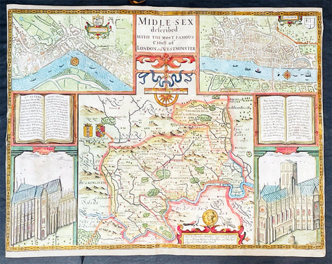
1676 John Speed Antique Map of County of Midlesex Views London & Westminster
- Title : Midle-sex Described with the most Famous Cities of London and Westminster
- Date : 1676
- Size: 20 1/4in x 16 3/4in (515mm x 425mm)
- Condition: (B) Good Condition
- Ref: 35613
Description:
This original hand coloured copper plate engraved antique map & views of London and the English county of Middlesex by John Speed was published in the 1676 Bassett & Chiswell edition of Speeds famous atlas The Theatre of the Empire of Great Britaine.
The map is embellished with the famous birds-eye views of London, Westminster and the churches of St Peters (Westminster Abbey) and old St Pauls before the great fire of London in 1666. English descriptive text of London on the verso.
General Definitions:
Paper thickness and quality: - Heavy and stable
Paper color : - off white
Age of map color: - Original
Colors used: - Blue, yellow, green, pink
General color appearance: - Authentic
Paper size: - 20 1/4in x 16 3/4in (515mm x 425mm)
Plate size: - 20 1/4in x 15 1/2in (515mm x 410mm)
Margins: - Min 1/8in (2mm)
Imperfections:
Margins: - L&R margins cropped to plate-marks
Plate area: - Re-enforced along centerfold very small loss in places, light creasing
Verso: - Re-enforced along centerfold and in several places with transparent archival tape
Background:
This county map of Middlesex, now greater London, illustrates the market towns of Enfield, Pancras, Osterley and Staines. The map is dominated by four large vignettes with the environs of London and the county situated in the central portion of the map. The actual cartography is based on the surveys performed by John Norden, the earlier English antiquary and map maker, who unsuccessfully attempted to publish an updated county atlas of the United Kingdom before Speed. Norden also lived most of his life in Middlesex, thus becoming an obvious source for the map.
The City of London is clearly shown on the lower right of the map with villages such as Hamsted, Pancras, Kensington and Paddington marked around the city. To the lower centre of the map is an acknowledgement to the original survey by Norden, augmented by Speed himself.
Although the cartography is of some note, it is the vignettes for which this map is justly famous. To the two bottom corners are the famous Churchs of St. Peter (Westminster Abbey) Westminster on the left and St. Pauls to the right. This is the medieval Cathedral of St. Pauls, just after it had lost its spire in 1561 and before the Great Fire of 1666, in which it was destroyed then rebuilt in its present form by Sir Christopher Wren. Above these two church vignettes are two text panels in the form of books, the one on the left describing the two churches and the other on the right with a description of London itself.
Finally, two large vignettes on the upper left and right corners depict the two cities of Westminster and London respectively. It is believed that Speed was not responsible for either of these images, more likely drawing from Norden, although there are no surviving evidence of this, to date yet to be found. There are also theories that these two views may have come from either a German sources or other lost birds-eye views of London by unknown persons.
Due to modern growth of London and border changes, the county of Middlesex no longer exists, but there is little doubt this is the most the best map of London and Middlesex published in the 17th century. English text on verso
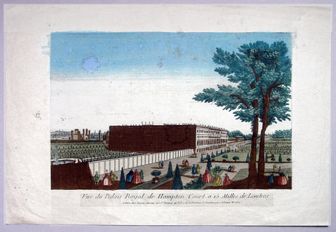
1760 Vue D Optic Antique Print View of Hampton Court Palace, Richmond London
- Title : Vue du Palias Royal de Hampton Court a 15 Milles de Londres
- Date : 1760
- Condition: (A) Very Good Condition
- Ref: 92704
- Size: 19in x 12 3/4in (480mm x 325mm)
Description:
This hand coloured original antique print, a view of Hampton Court Palace was published as part of the Vues d’Optique in 1760.
Hampton Court Palace: is a royal palace in the London Borough of Richmond upon Thames, Greater London, in the historic county of Middlesex, and within the postal town East Molesey, Surrey. It has not been inhabited by the British Royal Family since the 18th century. The palace is 11.7 miles (18.8 kilometres) south west of Charing Cross and upstream of central London on the River Thames. It was originally built in 1514 for Cardinal Thomas Wolsey, a favourite of King Henry VIII. In 1529, as Wolsey fell from favour, the King seized the palace for himself and later enlarged it. Along with St. James's Palace, it is one of only two surviving palaces out of the many owned by King Henry VIII.
In the following century, King William III's massive rebuilding and expansion project was intended to rival Versailles. Work ceased in 1694, leaving the palace in two distinct contrasting architectural styles, domestic Tudor and Baroque. While the palace's styles are an accident of fate, a unity exists due to the use of pink bricks and a symmetrical, if vague, balancing of successive low wings.
Vues d' Optique or Perspective Views: Perspective views, or "vues d'optique," are a special type of popular print published in Europe during the 18th century. These prints provided a form of entertainment when viewed through a device called an "optical machine" or an "optique." The most characteristic feature of the perspective views is their emphasized linear perspective, done to further intensify the enhanced appearance of depth and illusionistic space in the prints when viewed through an optique. When displayed in the optique, the prints might transport the viewer into a far away place---an unknown city, or perhaps into the midst of a dramatic bit of contemporary history. Another attribute of these prints is their bright, often heavy hand coloring, applied boldly so as to show the tints when viewed through the lens.
A number of perspective prints depicted American scenes at the time of the Revolution for a European audience hungry for news of the events in the British colonies. As documents of American history and European printmaking, these are unusual and appealing eighteenth-century prints.
General Description:
Paper thickness and quality: - Heavy & stable
Paper color: - Off white
Age of map color: - Original
Colors used: - Blue, yellow, green, red
General color appearance: - Authentic & bright
Paper size: - 19in x 12 3/4in (480mm x 325mm)
Plate size: - 14 1/2in x 9 1/2in (370mm x 240mm)
Margins: - Min 2in (50mm)
Imperfections:
Margins: - Light soiling
Plate area: - Small smudge & toning to sky
Verso: - Small repair, no loss