

Henry Charles Carey (1793 – 1879) Isaac Lea ( 1792 – 1886)
Henry Charles Carey and Isaac Lea were also known for their contributions to cartography, particularly in the field of American geography.
In 1822, Carey published "A New Map of the United States with the Contiguous British and Spanish Possessions," which was one of the first maps to show the United States extending from coast to coast. The map was based on new surveys and was much more accurate than previous maps of the country.
Isaac Lea was also involved in cartography and produced several maps of the United States, including a map of the country's geology and a map of the Mississippi River. He was also a member of the United States Coast Survey, which was responsible for creating nautical charts of the country's coastlines.
In 1827, Carey and Lea collaborated on the publication of "A Complete Historical, Chronological, and Geographical American Atlas," which contained over 100 maps of the United States and its territories. The atlas was one of the most comprehensive works of American geography at the time and was widely used by scholars and explorers.
Carey and Lea's contributions to American cartography helped to advance the field and improve the accuracy of maps of the United States. Their work continues to be studied and appreciated by historians and geographers today.
Carey & Lea (3)
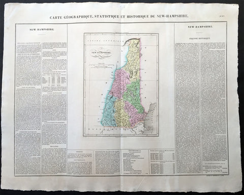
1825 Carey & Lea Buchon Large Antique Map of the State of New Hampshire, USA
-
Title : Carte Geographique, Statistique et Historique De New-Hampshire
- Ref #: 70006
- Size: 27 1/2in x 21 1/2in (700mm x 545mm)
- Date : 1825
- Condition: (A+) Fine Condition
Description:
This large beautifully hand coloured original antique map was published in the 1825 French edition of Carey & Lea's American Atlas by Jean Alexandre Buchon.
This map is in exceptionally fine condition, on clean, sturdy and stable heavy paper, heavy engraving and beautiful original hand colour.
In 1822, Henry Charles Carey and Isaac Lea published their American Atlas. This volume was based on Emmanuel Las Cases' Atlas Historique of 1803, with updated maps and text modified by Carey, a political economist.
He considered himself an American foil to John Stuart Mill and the London economists who were proclaimers of "the gloomy science" influenced by Ricardo and Malthus. Instead of preaching overpopulation and degeneration of the human species, Carey illustrated the nations of the western hemisphere through maps that showed an expanding region with ample promise of developing into lands of great new opportunity and growth. The sheets from this atlas, which cover North America, Central America, South America and the West Indies, are comprised of an engraved map surrounded by text documenting the history, climate, population and so forth of the area depicted. The atlas is particularly known for its excellent early maps of the states and territories of the United States. Many of these maps were drawn by Fielding Lucas, Jr., an important Baltimore cartographer. All of the maps show excellent and very up-to-date detail, providing fine verbal and graphic pictures of states and territories in the early 19th century (Ref: M&B; Tooley)
General Description:
Paper thickness and quality: - Heavy and stable
Paper color: - white
Age of map color: - Original
Colors used: - Yellow, green, blue, pink
General color appearance: - Authentic
Paper size: - 27 1/2in x 21 1/2in (700mm x 545mm)
Margins: - min. 1in (25mm)
Imperfections:
Margins: - None
Plate area: None
Verso: - None
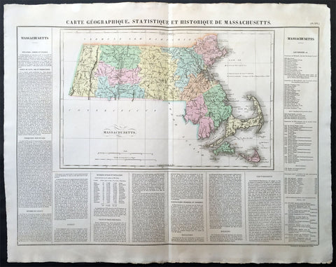
1825 Carey & Lea, Buchon Large Antique Map of the State of Massachusetts, USA
-
Title : Carte Geographique, Statistique et Historique Du Massachusetts
- Ref #: 70007
- Size: 27 1/2in x 21 1/2in (700mm x 545mm)
- Date : 1825
- Condition: (A+) Fine Condition
Description:
This large beautifully hand coloured original antique map was published in the 1825 French edition of Carey & Lea's American Atlas by Jean Alexandre Buchon.
This map is in exceptionally fine condition, on clean, sturdy and stable heavy paper, heavy engraving and beautiful original hand colour.
In 1822, Henry Charles Carey and Isaac Lea published their American Atlas. This volume was based on Emmanuel Las Cases' Atlas Historique of 1803, with updated maps and text modified by Carey, a political economist.
He considered himself an American foil to John Stuart Mill and the London economists who were proclaimers of "the gloomy science" influenced by Ricardo and Malthus. Instead of preaching overpopulation and degeneration of the human species, Carey illustrated the nations of the western hemisphere through maps that showed an expanding region with ample promise of developing into lands of great new opportunity and growth. The sheets from this atlas, which cover North America, Central America, South America and the West Indies, are comprised of an engraved map surrounded by text documenting the history, climate, population and so forth of the area depicted. The atlas is particularly known for its excellent early maps of the states and territories of the United States. Many of these maps were drawn by Fielding Lucas, Jr., an important Baltimore cartographer. All of the maps show excellent and very up-to-date detail, providing fine verbal and graphic pictures of states and territories in the early 19th century (Ref: M&B; Tooley)
General Description:
Paper thickness and quality: - Heavy and stable
Paper color: - white
Age of map color: - Original
Colors used: - Yellow, green, blue, pink
General color appearance: - Authentic
Paper size: - 27 1/2in x 21 1/2in (700mm x 545mm)
Margins: - min. 1in (25mm)
Imperfections:
Margins: - None
Plate area: None
Verso: - None
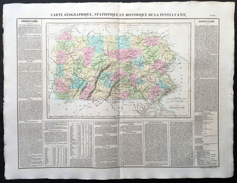
1825 Carey & Lea, Buchon Large Antique Map of the State of Pennsylvania, USA
-
Title : Carte Geographique, Statistique et Historique De la Pensylvanie
- Ref #: 70012
- Size: 27 1/2in x 21 1/2in (700mm x 545mm)
- Date : 1825
- Condition: (A+) Fine Condition
Description:
This large beautifully hand coloured original antique map was published in the 1825 French edition of Carey & Lea's American Atlas by Jean Alexandre Buchon.
This map is in exceptionally fine condition, on clean, sturdy and stable heavy paper, heavy engraving and beautiful original hand colour.
In 1822, Henry Charles Carey and Isaac Lea published their American Atlas. This volume was based on Emmanuel Las Cases' Atlas Historique of 1803, with updated maps and text modified by Carey, a political economist.
He considered himself an American foil to John Stuart Mill and the London economists who were proclaimers of "the gloomy science" influenced by Ricardo and Malthus. Instead of preaching overpopulation and degeneration of the human species, Carey illustrated the nations of the western hemisphere through maps that showed an expanding region with ample promise of developing into lands of great new opportunity and growth. The sheets from this atlas, which cover North America, Central America, South America and the West Indies, are comprised of an engraved map surrounded by text documenting the history, climate, population and so forth of the area depicted. The atlas is particularly known for its excellent early maps of the states and territories of the United States. Many of these maps were drawn by Fielding Lucas, Jr., an important Baltimore cartographer. All of the maps show excellent and very up-to-date detail, providing fine verbal and graphic pictures of states and territories in the early 19th century (Ref: M&B; Tooley)
General Description:
Paper thickness and quality: - Heavy and stable
Paper color: - white
Age of map color: - Original
Colors used: - Yellow, green, blue, pink
General color appearance: - Authentic
Paper size: - 27 1/2in x 21 1/2in (700mm x 545mm)
Margins: - min. 1in (25mm)
Imperfections:
Margins: - Light age toning
Plate area: Light age toning
Verso: - Light age toning