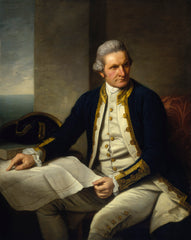
James Cook (1728-1779)
Profile:
Captain James Cook (1728-1779) was a British explorer, navigator, and cartographer who is known for his extensive voyages to the Pacific Ocean. Born in Marton, Yorkshire, England, Cook began his maritime career as an apprentice at the age of 17. He served as a naval officer during the Seven Years' War, mapping the coastlines of Newfoundland and St. Lawrence River.
In 1768, Cook was selected to lead an expedition to the Pacific Ocean to observe the transit of Venus across the sun, and to search for the fabled southern continent. During this voyage, he charted the east coast of Australia, claiming it for Britain and naming it New South Wales. Cook's second voyage, from 1772 to 1775, was dedicated to exploring the southern oceans, circumnavigating Antarctica and proving that it was a continent.
Cook's third voyage, from 1776 to 1779, was his most famous. He was tasked with finding a northwest passage to connect the Atlantic and Pacific Oceans. While he did not find the passage, he did explore the coast of Alaska and made detailed maps of the region. Cook was also the first European to visit Hawaii, where he was initially welcomed, but was later killed in a skirmish with locals.
Cook was known for his excellent navigational skills and his ability to prevent scurvy among his crew by introducing fresh food and lemon juice into their diets. He also made significant contributions to the field of cartography, creating accurate maps of the Pacific and the coastlines he explored.
Cook's voyages had a significant impact on the scientific and cultural understanding of the world. His accurate maps and charts greatly improved navigational methods and were used by sailors for many years to come. Cook's legacy also includes his interactions with the people he encountered during his voyages, which played a significant role in shaping the understanding of different cultures in Europe.
Cook's First Voyage (1768-1771)
The first voyage under Captain James Cook's command was primarily of a scientific nature. The expedition on the Endeavour initially sailed to Tahiti to observe the transit of the planet Venus in order to calculate the earth's distance from the sun. Cook landed on the South Pacific island in April of 1769 and in June of that year the astronomical observations were successfully completed. In addition to these labors, very good relations with the Tahitians were maintained and the naturalists Joseph Banks and Daniel C. Solander conducted extensive ethnological and botanical research. Another purpose of the voyage was to explore the South Seas to determine if an inhabitable continent existed in the mid-latitudes of the Southern Hemisphere.
Upon leaving Tahiti, Cook named and charted the Society Islands and then continued southwest to New Zealand. His circumnavigation and exploration of that country also resulted in a detailed survey. Cook proceeded to Australia, where he charted the eastern coast for 2,000 miles, naming the area New South Wales. As a result of these surveys, both Australia and New Zealand were annexed by Great Britain. In addition to these explorations, the Endeavour returned to England without a single death from scurvy among its men, an historic feat at the time. The combination of these accomplishments brought Cook prominence, promotion, and the opportunity to lead further expeditions.
Cook's Second Voyage (1772-1775)
Based on the success of his first voyage, Cook was appointed by the Admiralty to lead a second expedition. Two ships were employed with Cook commanding the Resolution and Captain Tobias Furneaux in charge of the Adventure. The purpose was to circumnavigate the globe as far south as possible to confirm the location of a southern continent. Cook proved that there was no "Terra Australis," which supposedly was located between New Zealand and South America. Cook was convinced, however, that there was land beyond the southern ice fields.
In his pursuit of this idea, this expedition was the first European voyage to cross the Antarctic Circle. In addition, in two great sweeps through the Southern latitudes, Cook made an incredible number of landfalls including New Zealand, Easter Island, the Marquesas, Tahiti and the Society Islands, the Tonga Islands, the New Hebrides, New Caledonia, and a number of smaller islands. In addition to these navigational accomplishments and the accompanying expansion of geographical knowledge, the expedition also recorded a vast amount of information regarding the Pacific islands and peoples, proved the value of the chronometer as an instrument for calculating longitude, and improved techniques for preventing scurvy.
Cook's Third Voyage (1776-1779)
In the course of his first two voyages, Cook circumnavigated the globe twice, sailed extensively into the Antarctic, and charted coastlines from Newfoundland to New Zealand. Following these achievements, Cook's third voyage was organized to seek an efficient route from England to southern and eastern Asia that would not entail rounding the Cape of Good Hope. The search for such a Northwest (or Northeast) Passage had been on the agenda of northern European mariners and merchants since the beginning of European expansion in the late fifteenth century.
England's growing economic and colonial interests in India in the later eighteenth century provided the stimulus for the latest exploration for this route. Cook, again in command of the Resolution, was to approach the Northwest Passage from the Pacific accompanied by a second ship, the Discovery, captained by Charles Clerke. The ships left England separately, regrouped at Cape Town, and continued on to Tasmania, New Zealand, and Tahiti. The expedition then sailed north and made landfall at Christmas Island and the Hawaiian Islands. Cook continued northward and charted the west coast of North America from Northern California as far as the Bering Strait. He returned to Hawaii for the winter and was killed in a skirmish with natives on February 14, 1779. Upon Cook's death, Clerke took command of the expedition but died six months later. The ships returned to England in 1780 under John Gore, who had commanded the Discovery after Cook's death. From start to finish, the voyage had lasted more than four years.
Captain James Cook (98)
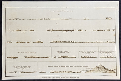
1784 Anderson Antique Coastal Views of the Admiralty Isles of PNG & Mindanao Islands - Capt Cook 1767
- Title : Three Views of the Admiralty Isles; Two islands seen 24th September 1767; Seen the 26 of September 1767, Joseph Freewills Islands; An island seen from the mast head & this view taken there September 29th 1767, S. 50W; An island seen from the mast head & this view taken October 12th 1767. Current Island, N.E. 1/2 E; Seen only from the mast head where this view was taken October 15, 1767. St. Andrews Islands; Three islands seen from our anchoring place in the Bay at the south end of Mindinao.
- Date : 1784
- Ref # : 21696
- Size : 13in x 9in (330mm x 230mm)
- Condition: (A+) Fine Condition
Description:
This fine original copper-plate engraved antique 8 nautical chart & coastal view of the Admiralty Islands, off the coast of north PNG, along with St Andrews & Joseph Freewill Islands sighted by James Cook from September to October 1767 and the last view being a coastal view of southern Mindanao Islands in the Philippines, was published in George Andersons 1784 edition of A Collection of voyages round the world : performed by royal authority : containing a complete historical account of Captain Cooks first, second, third and last voyages, undertaken for making new discoveries, &c. ... published by Alexander Hogg, London 1784.
1.2.3 Three Views of the Admiralty Isles
4. Two islands seen 24th September 1767
5. Seen the 26 of September 1767, Joseph Freewills Islands
6. An island seen from the mast head & this view taken there September 29th 1767, S. 50W.
7. An island seen from the mast head & this view taken October 12th 1767. Current Island, N.E. 1/2 E.
8. Seen only from the mast head where this view was taken October 15, 1767. St. Andrews Islands
9. Three islands seen from our anchoring place in the Bay at the south end of Mindinao.
General Definitions:
Paper thickness and quality: - Heavy and stable
Paper color : - off white
Age of map color: -
Colors used: -
General color appearance: -
Paper size: - 13 1/2in x 9 1/2in (345mm x 240mm)
Plate size: - 13 1/2in x 9 1/2in (345mm x 240mm)
Margins: - Min 1/2in (12mm)
Imperfections:
Margins: - None
Plate area: - None
Verso: - None
Background:
The Admiralty Islands are an archipelago group of 18 islands in the Bismarck Archipelago, to the north of New Guinea in the South Pacific Ocean. These are also sometimes called the Manus Islands, after the largest island.
Mindanao is the second largest island in the Philippines. Mindanao and the smaller islands surrounding it make up the island group of the same name.
Cooks First Voyage (1768–71) In 1766, the Admiralty engaged Cook to command a scientific voyage to the Pacific Ocean. The purpose of the voyage was to observe and record the transit of Venus across the Sun for the benefit of a Royal Society inquiry into a means of determining longitude. Cook, at the age of 39, was promoted to lieutenant to grant him sufficient status to take the command. For its part the Royal Society agreed that Cook would receive a one hundred guinea gratuity in addition to his Naval pay.
The expedition sailed aboard HMS Endeavour, departing England on 26 August 1768. Cook and his crew rounded Cape Horn and continued westward across the Pacific to arrive at Tahiti on 13 April 1769, where the observations of the Venus Transit were made. However, the result of the observations was not as conclusive or accurate as had been hoped. Once the observations were completed, Cook opened the sealed orders which were additional instructions from the Admiralty for the second part of his voyage: to search the south Pacific for signs of the postulated rich southern continent of Terra Australis. Cook then sailed to New Zealand and mapped the complete coastline, making only some minor errors. He then voyaged west, reaching the south-eastern coast of Australia on 19 April 1770, and in doing so his expedition became the first recorded Europeans to have encountered its eastern coastline.
On 23 April he made his first recorded direct observation of indigenous Australians at Brush Island near Bawley Point, noting in his journal: “...and were so near the Shore as to distinguish several people upon the Sea beach they appear\\\'d to be of a very dark or black Colour but whether this was the real colour of their skins or the Clothes they might have on I know not. On 29 April Cook and crew made their first landfall on the mainland of the continent at a place now known as the Kurnell Peninsula. Cook originally christened the area as \\\"Stingray Bay\\\", but later he crossed this out and named it Botany Bay after the unique specimens retrieved by the botanists Joseph Banks and Daniel Solander. It is here that James Cook made first contact with an aboriginal tribe known as the Gweagal.
After his departure from Botany Bay he continued northwards. He stopped at Bustard Bay (now known as Seventeen Seventy or 1770) at 8 o’clock on 23 May 1770. On 24 May Cook and Banks and others went ashore. Continuing north, on 11 June a mishap occurred when HMS Endeavour ran aground on a shoal of the Great Barrier Reef, and then nursed into a river mouth on 18 June 1770. The ship was badly damaged and his voyage was delayed almost seven weeks while repairs were carried out on the beach (near the docks of modern Cooktown, Queensland, at the mouth of the Endeavour River). The voyage then continued, sailing through Torres Strait and on 22 August Cook landed on Possession Island, where he claimed the entire coastline that he had just explored as British territory. He returned to England via Batavia (modern Jakarta, Indonesia), where many in his crew succumbed to malaria, and then the Cape of Good Hope, arriving at the island of Saint Helena on 12 July 1771.
Cook\\\'s journals were published upon his return, and he became something of a hero among the scientific community. Among the general public, however, the aristocratic botanist Joseph Banks was a greater hero. Banks even attempted to take command of Cook\\\'s second voyage, but removed himself from the voyage before it began, and Johann Reinhold Forster and his son Georg Forster were taken on as scientists for the voyage. Cook\\\'s son George was born five days before he left for his second voyage.
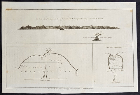
1784 Anderson Antique Map Nendo Isle & Nupani Atoll on the Solomon Islands Capt. Carteret 1767
- Title : The north side of the largest of Queen Charlottes Islands as it appeared running along shore to the Westward; South side of a Vulcano, 6 leagues north of the above; Swallows Bay; Byrons Harbour.
- Date : 1780
- Ref # : 21607
- Size : 13in x 9in (330mm x 230mm)
- Condition: (A+) Fine Condition
Description:
This fine original copper-plate engraved antique nautical chart & coastal view of the Island of Nendo (then called Lord Egmonts Island or New Guernsey) along with inset maps of Swallow Bay & Byrons Harbour on Nendo and a view of the nearby volcanic island of Nupani was drawn by Captain Phillip Carteret in July-August 1767 aboard his ship Swallow, was published in George Andersons 1784 edition of A Collection of voyages round the world : performed by royal authority : containing a complete historical account of Captain Cooks first, second, third and last voyages, undertaken for making new discoveries, &c. ... published by Alexander Hogg, London 1784.
General Definitions:
Paper thickness and quality: - Heavy and stable
Paper color : - off white
Age of map color: -
Colors used: -
General color appearance: -
Paper size: - 13 1/2in x 9 1/2in (345mm x 240mm)
Plate size: - 13 1/2in x 9 1/2in (345mm x 240mm)
Margins: - Min 1/2in (12mm)
Imperfections:
Margins: - None
Plate area: - None
Verso: - None
Background:
Capt. Philip Carteret (1733-1796)
was a British naval officer and explorer who participated in two of the Royal Navy\\\'s circumnavigation expeditions in 1764-66 and 1766-69.
Carteret entered the Navy in 1747, serving aboard the Salisbury, and then under Captain John Byron from 1751 to 1755. Between 1757 and 1758 he was in the Guernsey on the Mediterranean Station. As a lieutenant in the Dolphin he accompanied Byron during his voyage of circumnavigation, from June 1764 to May 1766.
In 1766 he was made a commander and given the command of the Swallow to circumnavigate the world, as consort to the Dolphin under the command of Samuel Wallis. The two ships were parted shortly after sailing through the Strait of Magellan, Carteret discovering Pitcairn Island and the Carteret Islands, which were subsequently named after him. In 1767, he also discovered a new archipelago inside Saint George\\\'s Channel between New Ireland and New Britain Islands (Papua New Guinea) and named it Duke of York Islands, as well as rediscovered the Solomon Islands first sighted by the Mendana in 1568, and the Juan Fernandez Islands first discovered by Juan Fernandez in 1574. He arrived back in England, at Spithead, on 20 March 1769.
He was promoted to post captain in 1771.
Nendo is the largest of the Santa Cruz Islands, located in the Temotu province of the Solomon Islands. The island is also known as Santa Cruz, Ndeni, Nitendi or Ndende. The name Santa Cruz was given to the island in 1595 by the Spanish navigator Alvaro de Mendaña, who unsuccessfully started a colony there.
The Nupani Atoll is located about 65 km to the West of the main group of the Reef Islands.