America (2)
1773 Cook Antique Maps Tahiti, Raiatea & Huaheine Isles French Polynesia in 1769
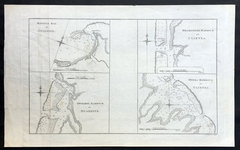
- Title : Matavia Bay in Otaheite ; Owharre Harbour in Huaheine ; Ohamaneno Harbour in Ulietea ; Oopoa Harbour in Ulietea
- Size: 17in x 10 1/2in (430mm x 265mm)
- Ref #: 31216
- Date : 1773
- Condition: (A+) Fine Condition
Description:
This fine original copper-plate engraved antique map, four maps on the one sheet;
1. Matavia Bay, Tahiti (Otaheite) - Windward Islands
2. Ohamaneno (Vaiaau) Harbour Raiatea (Ulietea) - Leeward Islands
3. Owharre (Bourayne Bay) Harbour in Huaheine - Leeward Islands
4. Oopoa (Opoa) Harbour, Raiatea (Ulietea) - Leeward Islands
all located in French Polynesia, South Pacific were complied by Capt James Cook during his first voyage of discovery in 1769, was published in the 1773 edition of John Hawkesworths An Account of the Voyages Undertaken by the Order of His Present Majesty for Making Discoveries in the Southern Hemisphere and Successively Performed by Commodore Byron, Captain Wallis, Captain Carteret, and Captain Cook, in the Dolphin, the Swallow, and the Endeavor, Drawn Up from the Journals Which Were Kept by the Several Commanders, and from the Papers of Joseph Banks, Esq. Paris 1773
General Definitions:
Paper thickness and quality: - Heavy and stable
Paper color : - off white
Age of map color: -
Colors used: -
General color appearance: -
Paper size: - 17in x 10 1/2in (430mm x 265mm)
Plate size: - 14 1/2in x 10 1/2in (365mm x 260mm)
Margins: - Min 1/2in (12mm)
Imperfections:
Margins: - None
Plate area: - Light creasing
Verso: - None
Background:
Matavai Bay is located on the north coast of Tahiti, the largest island in the Windward group of French Polynesia.
The first European known to have visited Tahiti was Lieutenant Samuel Wallis, in Dolphin, who landed on 17 June 1767 in Matavai Bay.
Captain James Cook anchored in the bay on 13 April 1769, on a sandy spit on the northeast end of Matavai Bay - named Point Venus by Cook.
Raiatea, is the second largest of the Society Islands, after Tahiti, in French Polynesia. The island is widely regarded as the centre of the eastern islands in ancient Polynesia and it is likely that the organised migrations to Hawaii, Aotearoa and other parts of East Polynesia started at Raiātea.
Captain Cook visited Raiatea in 1769 and again in 1773-1774.
Huahine is an island located among the Society Islands, in French Polynesia, an overseas territory of France in the Pacific Ocean. It is part of the Leeward Islands group (Iles sous le Vent).
Captain Cook arrived Fare Harbour on 16 July 1769, with Tupaia navigating the HMS Endeavour. They met with leading chief Ori (Mato). Cook returned on 3 Sept. 1773 and met with Oris son Teri itaria, the new ari i rahi of the island.
John Hawkesworth 1715 – 1773
An English writer and journalist, Hawkesworth was commissioned by the British Admiralty to edit for publication the narratives of its officers’ circumnavigations. He was given full access to the journals of the commanders and the freedom to adapt and re-tell them in the first person. Cook was already on his way back from his second Pacific voyage, temporarily docked at Cape Town (South Africa), when he first saw the published volumes: he was mortified and furious to find that Hawkesworth claimed in the introduction that Cook had seen and blessed (with slight corrections) the resulting manuscript. (In his defense, Hawkesworth also had been a victim of misunderstanding.) Cook had trouble recognizing himself. Moreover, the work was full of errors and commentary introduced by Hawkesworth and, in Cook’s view, too full of Banks, who had promoted himself and the publication. Still, the work was popular; the first edition sold out in several months.
1774 Hawkesworth Antique Map of Magellan Straits, Bachelor River, Punta Arenas, Chile, Byron 1766
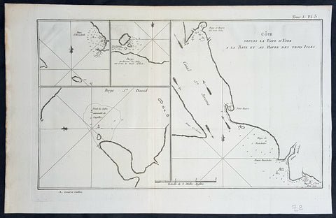
- Title : Baye d Elizabeth; Baye au dessons des Isles vis a vis la Rade d York; Côte depuis la Baye d York a la Baye et au Havre des Trois Isles; Baye St. David
- Size: 15 1/2in x 10in (395mm x 255mm)
- Ref #: 16027
- Date : 1774
- Condition: (A+) Fine Condition
Description:
This fine original copper-plate engraved antique map, four maps on the one sheet, of;
1. Elizabeth Bay.
2. York Bay.
3. York Bay-Three Island Bay
4.St. Davids Bay.
all located north of Carlos III island, on Punta Arenas in the Chilean Arctic - from Bachelor River north to York Bay - in the Straits of Magellan, Chile. This chart was compiled by Commodore John Byron, who visited the region in HMS Dolphin on his circumnavigation of the globe, between 1764-66, and was published in the 1774 French edition of John Hawkesworths An Account of the Voyages Undertaken by the Order of His Present Majesty for Making Discoveries in the Southern Hemisphere and Successively Performed by Commodore Byron, Captain Wallis, Captain Carteret, and Captain Cook, in the Dolphin, the Swallow, and the Endeavor, Drawn Up from the Journals Which Were Kept by the Several Commanders, and from the Papers of Joseph Banks, Esq. Paris 1774
General Definitions:
Paper thickness and quality: - Heavy and stable
Paper color : - off white
Age of map color: -
Colors used: -
General color appearance: -
Paper size: - 15 1/2in x 10in (395mm x 255mm)
Plate size: - 14in x 10in (360mm x 255mm)
Margins: - Min 1/2in (12mm)
Imperfections:
Margins: - None
Plate area: - None
Verso: - None
Background:
The Strait of Magellan
(Estrecho de Magallanes) is a navigable sea route separating mainland South America to the north and Tierra del Fuego to the south. The strait is the most important natural passage between the Atlantic and Pacific oceans.
Ferdinand Magellan a Portuguese explorer and navigator in the service of Charles I of Spain, became the first European to navigate the strait in 1520 during his circumnavigation of the globe.
Other early explorers included Francis Drake (1578). In February 1696 the first French expedition, under the command of M. de Gennes reached the Strait of Magellan. The expedition is described by the young French explorer, engineer and hydrographer François Froger in his A Relation of a Voyage (1699).
The strait was first carefully explored and thoroughly charted by Phillip Parker King, who commanded the British survey vessel HMS Adventure, and in consort with HMS Beagle spent five years surveying the complex coasts around the strait (1826–1830). A report on the survey was presented at two meetings of the Geographical Society of London in 1831.
Vice-Admiral The Hon. John Byron was a British Royal Navy officer and politician. He was known as Foul-weather Jack because of his frequent encounters with bad weather at sea. As a midshipman, he sailed in the squadron under George Anson on his voyage around the world, though Byron made it to southern Chile, and returned to England with the captain of HMS Wager. He was governor of Newfoundland following Hugh Palliser, who left in 1768. He circumnavigated the world as a commodore with his own squadron in 1764-1766. He fought in battles in The Seven Years War and the American Revolution. He rose to Vice Admiral of the White before his death in 1786.
In early 1764 the British Admiralty determined that it would require a permanent naval settlement off the South American coast, in order to resupply naval vessels seeking to enter the Pacific via Cape Horn. Captain Byron was selected to explore the South Atlantic for a suitable island upon which to establish such a settlement. The South American mainland was controlled by Spain, which was hostile to local expansion of British interests; to disguise Byrons mission it was announced that he had been appointed the new commander of the Navys East Indies Station. Byron set sail in June 1764, ostensibly to take up the East Indies post. For the voyage he was granted command of the 24-gun frigate HMS Dolphin and the 20-gun sloop HMS Tamar.
Byron\'s two-vessel flotilla crossed the Atlantic over the winter of 1764 and made its way slowly down the South American coast. The Admiralty had ordered Byron to first seek Pepys Island, reputedly discovered off the Patagonian coast by the corsair Ambrose Cowley in 1683. Byron reached the co-ordinates given by Cowley in January 1765, but there was no sign of the island and the search was swiftly abandoned. On 5 February Byron reached the Patagonian settlement of Port Desire where he resupplied his vessels from the storeship HMS Florida.
Between June 1764 and May 1766, Byron completed his own circumnavigation of the globe as captain of HMS Dolphin. This was the first such circumnavigation that was accomplished in less than 2 years. His actions nearly caused a war between Great Britain and Spain, as both countries had armed fleets ready to contest the sovereignty of the Falkland Islands. Later Byron encountered islands and extant residents of the Tuamotus and Tokelau Islands, and Nikunau in the southern Gilbert Islands; he also visited Tinian in the Northern Marianas Islands.