
America (3)
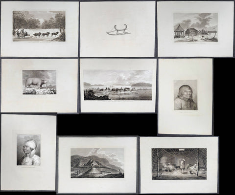
1784 James Cook 9 x Antique 1st Edition Prints of Petropavlovsk-Kamchatsky, Kamchatka Russia, 1779
Antique Print
- Title : A Man of Kamtschatka, Travelling in Winter; A Sledge of Kamtschatka; A View at Bolcheretzkoi, in Kamtschatka; A White Bear; A View of the Town and Harbour of St Peter and St Paul, in Kamtschatka; A Man of Kamtschatka; A Woman of Kamtschatka; Summer and Winter Habitations in Kamtschatka; The Inside of a Winter Habitation in Kamtschatka.
- Ref : 61231; 61273; 61232; 61233; 61274; 61234; 61235; 61236; 61275.
- Size: 21in x 15 1/2in (535mm x 395mm)
- Date : 1784
- Condition: (A+) Fine Condition
Description:
This scarce, complete set of nine first-edition large antique prints (Plates #70 through #78) represents the entire visual record from the third expedition's historic visit to Kamchatka, Siberia. These illustrations were captured during the spring and summer of 1779 during the crew's second, unsuccessful attempt to locate the elusive Northwest Passage following Captain James Cook's tragic death. The original drawings by John Webber (Cooks official onboard artist) were expertly engraved by Samuel Middleman; Thomas Goodyer; Paul Benezech; Peter Mazell; B T Pouncy; William Sharp; Samuel Smith; William Sharp respectively for the official, British Admiralty-sanctioned account of Cooks third and final journey: "A Voyage to the Pacific Ocean... In Three Volumes. Vol. I & II and Atlas, written by James Cook & Capt J Clerk, F.R.S. Vol. III in London, 1784.
In 1778 the expedition had surveyed the North American coast from Nootka Sound to Alaska, passed through the Bering Strait, and been turned back by pack ice off Icy Cape in August. They then wintered in Hawaii, where Cook was killed in February 1779.
The expedition returned to the NW American coast on 29 April 1779, under Charles Clerke and John Gore, and stayed until 16 June. The Russians at the settlement of St Peter and St Paul (now Petropavlovsk-Kamchatsky) helped with provisions and repairs and forwarded the expedition's dispatches, and Webber drew the settlement in "A View of the Town and Harbour of St Peter and St Paul, in Kamtschatka." Officers, including James King and Webber, also travelled to Bolcheretzkoi (now Bolsheretsk), on Kamchatka's west coast, to meet the Russian commandant, Major Behm, which is the subject of "A View at Bolcheretzkoi, in Kamtschatka." Webber's studies of the people he met became "A Man of Kamtschatka" and "A Woman of Kamtschatka" (Kamtschatka being the spelling of Kamchatka used in 1784), and his drawings of how they lived became "Summer and Winter Habitations in Kamtschatka" and "The Inside of a Winter Habitation in Kamtschatka." Winter travel, which the crews saw in the local dog teams, appears in "A Sledge of Kamtschatka" and "A Man of Kamtschatka, Travelling in Winter."
The ships left on 16 June for a second, failed attempt on the Arctic ice, and "A White Bear" recalls those northern waters. Clerke died on 22 August, and the ships were back at Petropavlovsk by 24 August, where he was buried. Webber's panoramic drawing of the town dates from late August and early September 1779.
The ships finally left Kamchatka in October, bound for Macau and home.
Exceptional and highly sought-after large museum quality prints, perfect for collectors of Captain Cook history, maritime art, and early Australian, Pacific, American & Polar exploration.
General Definitions:
Paper thickness and quality: - Heavy and stable
Paper color : - off white
Age of map color: -
Colors used: -
General color appearance: -
Paper size: - 21in x 15 1/2in (535mm x 395mm)
Plate size: - Various sizes please see below in background for individual sizes.
Margins: - Min 2in (50mm)
Imperfections:
Margins: - Light creasing
Plate area: - None
Verso: - Light creasing
Background:
Captain James Cook's third and final voyage (1776–1780) set out from Plymouth to search for a Northwest Passage between the Pacific and Atlantic, sailing via the Cape of Good Hope and the Kerguelen Islands before visiting Tasmania and New Zealand and threading through the Pacific islands — Tonga, Tahiti, and the Society Islands — over the course of 1777. In January 1778 Cook became the first European to reach the Hawaiian Islands, which he named the Sandwich Islands, and from there sailed to the west coast of North America, charting the coastline from Oregon up through Nootka Sound, Unalaska (Alaska), and the Bering Strait into the Arctic Ocean, where pack ice forced him to turn back in August 1778. He wintered in Hawaii, anchoring at Kealakekua Bay in January 1779, where a dispute with islanders turned violent and Cook was killed on 14 February 1779. Command passed to Charles Clerke, who made one more unsuccessful attempt at the Northwest Passage before the expedition sailed home via Kamchatka Peninsula (Russia) , Macau, and the Cape of Good Hope, finally reaching England in October 1780.
Captain James Cook's third and final voyage A Voyage to the Pacific Ocean... In Three Volumes. Vol. I & II and Atlas, was illustrated in the original 1784/5 atlas containing 2 maps and 61 prints, engraved after John Webber's drawings (Cooks official artist on the voyage) by various engravers. Below is each location visited by Cook and later Capt. Clerk with the dates and corresponding prints.
Kerguelen Islands (Christmas Harbour) — 25 December 1776
• Plate 4 — A View of Christmas Harbour, in Kerguelen's Land
Van Diemen's Land (Tasmania), Adventure Bay — January 1777
• Plate 6 — A man of Van Diemen's Land
• Plate 7 — A woman of Van Diemen's Land
• Plate 8 — An opossum of Van Diemen's Land
Queen Charlotte Sound, New Zealand — February 1777
• Plate 10 — The Inside of a Hippah in New Zeeland
Mangaia, Cook Islands — March–April 1777
• Plate 11 — A man of Mangea
Tongan (Friendly) Islands — April–July 1777
• Plate 13 — A view at Anamooka
• Plate 14 — The reception of Captain Cook, in Hapaee
• Plate 15 — A boxing match, in Hapaee
• Plate 16 — A night dance by men, in Hapaee
• Plate 17 — A night dance by women, in Hapaee
• Plate 18 — Poulaho, King of the Friendly Islands
• Plate 20 — Poulaho, King of the Friendly Islands, drinking kava
• Plate 21 — A Fiatooka (Morai), in Tongataboo
• Plate 22 — The Natche, a ceremony in Tongataboo
• Plate 23 — A woman of Eaoo
Tahiti (Otaheite) — August 1777
• Plate 25 — A human sacrifice, in a marai
• Plate 26 — The body of Tee, a chief, as preserved after death
• Plate 27 — A young woman of Otaheite, bringing a present
• Plate 28 — A dance in Otaheite
• Plate 29 — A young woman of Otaheite, dancing
Huahine, Society Islands — October–November 1777
• Plate 31 — A view of Huaheine
Christmas Island (Kiritimati) — December 1777
• Discovered on this leg of the voyage; not separately plated
Kauai (Atooi), Hawaiian Islands — January 1778 (first European landfall in Hawaii) • Plate 33 — A Morai, in Atooi
• Plate34 — The inside of the house, in the Morai
• Plate 35 — An inland view, in Atooi
Nootka Sound, Vancouver Island — March–April 1778
• Plate 38 — A man of Nootka Sound
• Plate 39 — A woman of Nootka Sound
• Plate 40 — Various articles, at Nootka Sound
• Plate 41 — A view of the habitation in Nootka Sound
• Plate 42 — The inside of a house in Nootka Sound
• Plate 43 — A sea otter
Prince William Sound, Alaska — May 1778
• Plate 45 — A view of Snug Corner, in Prince William Sound
• Plate 46 — A man of Prince William Sound
• Plate 47 — A woman of Prince William Sound
Unalaska (Oonalashka) — June and October 1778
• Plate 48 — A man of Oonalashka
• Plate 49 — A woman of Oonalashka
• Plate 50 — Canoes of Oonalashka
• Plate 56 — Caps of the natives of Oonalashka
• Plate 57 — Natives of Oonalashka, and their habitations
• Plate 58 — The inside of a house, in Oonalashka
Norton Sound and the Chukchi Coast, Siberia — August 1778
• Plate 51 — The Tschuktschi, and their habitations
• Plate 54 — Inhabitants of Norton Sound and their habitations
Arctic Ocean, near the Bering Strait — August 1778 (Cook turned back by ice)
• Plate 52 — Sea horses (walruses)
Kealakekua Bay, Hawaii (Owyhee) — January–February 1779 (Cook killed 14 February 1779)
• Plate 60 — An offering before Captain Cook, in the Sandwich Islands
• Plate 61 — Tereoboo, King of Owyhee, bringing presents to Captain Cook
• Plate 62 — A man of the Sandwich Islands, dancing
• Plate 63 — A young woman of the Sandwich Islands
• Plate 64 — A man of the Sandwich Islands, with his helmet
• Plate 65 — A canoe of the Sandwich Islands, the rowers masked
• Plate 66 — A man of the Sandwich Islands, in a mask
• Plate 67 — Various articles, at the Sandwich Islands
• Plate 68 — A view of Karakakooa, in Owyhee
Kamchatka, St Peter and St Paul Harbour (Petropavlovsk) — spring and summer 1779
• Plate 70 — A man of Kamtschatka, travelling in winter - 16in x 10in (405mm x 255mm)
• Plate 71 — A sledge of Kamtschatka - 10in x 7 1/2in (255mm x 190mm)
• Plate 72 — A view at Bolcheretzkoi, in Kamtschatka - 13 1/2in x 9 1/2in (345mm x 240mm)
• Plate 73 — A white bear - 10 1/2in x 8 1/2in (265mm x 215mm)
• Plate 74 — A view of the town and harbour of St Peter and St Paul - 20 1/2in x 10in (520mm x 255mm)
• Plate 75 — A man of Kamtschatka - 12in x 9 1/2in (305mm x 240mm)
• Plate 76 — A woman of Kamtschatka - 12in x 9 1/2in (305mm x 240mm)
• Plate 77 — Summer and winter habitations, in Kamtschatka - 16in x 9 1/2in (405mm x 240mm)
• Plate 78 — The inside of a winter habitation in Kamtschatka - 16 1/2in x 10in (420mm x 255mm)
Return to England — October 1780
John Webber (1751–1793) was a Swiss-born British artist who served as the official expedition artist on Cook's third voyage, tasked with visually documenting the peoples, landscapes, and events the ships encountered. His drawings — later engraved as the 61 plates in the atlas accompanying the 1784 official account — provided some of the first detailed European depictions of Hawaii, the Pacific Northwest coast, and other Pacific and Arctic locales, including the scene of Cook's death at Kealakekua Bay. Webber was elected a full Royal Academician in 1791 and continued to exhibit landscape work until his death in 1793.
1784 James Cook & John Webber Antique 1st Edition Print Village in Chukotski Peninsula, Siberia , 1778
Antique Print
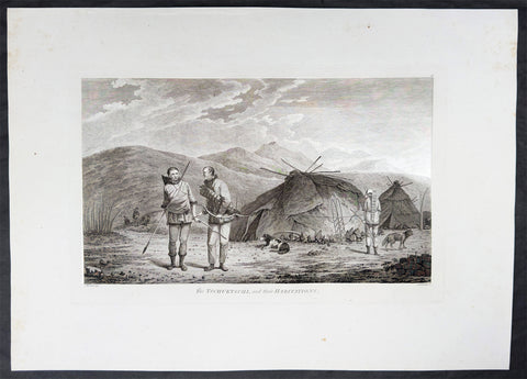
- Title : The Tschuktschi, and their Habitations
- Ref : 61228
- Size: 21 3/4in x 15 1/2in (550mm x 395mm)
- Date : 1784
- Condition: (A) Very Good Condition
Description:
This scarce first-edition large antique print, plate #51, the only plate illustrating the Chukotski Peninsula in Siberia, of a view of a Chukotski Village & its inhabitants in August 1778, was drawn by John Webber (Cooks official onboard artist) and expertly engraved by Daniel Lerpiniere for the official, British Admiralty-sanctioned account of Cooks journey: "A Voyage to the Pacific Ocean... In Three Volumes. Vol. I & II and Atlas, written by James Cook & Capt J Clerk, F.R.S. Vol. III in London, 1784.
In the summer of 1778, Cook's search for the Northwest Passage took him to both sides of the Bering Strait. He landed on the Chukotski Peninsula in Siberia on 10 August and met the Chukchi, who welcomed his party, and the two sides traded European knives, beads and tobacco for Chukchi clothes, gloves and arrows. Though the visit lasted only a few hours, Webber sketched their clothing, dogs and dome-shaped summer huts, and these became the plate "The Tschuktschi, and their Habitations".
The ships then passed north through the strait on 11 August. Pack ice stopped them off Alaska on 18 August, at about 70°N, and Cook spent the next eleven days working westward along the ice edge before reaching the Siberian coast again on 29 August. He gave up the search then and sailed south through the strait on 2 September. Turning to the Alaskan side, he explored the inlet he named Norton Sound after Sir Fletcher Norton, Speaker of the House of Commons, naming Cape Denbigh on 11 September and Besborough Island on 12 September. Like the Siberian coast, it offered no way through, since Norton Sound proved a shallow gulf and not a passage. Webber's plate of a family with their shelter and kayak is the main record of the people there. Cook then sailed for Unalaska and, after repairs, south to Hawaii for the winter.
Exceptional and highly sought-after large museum quality prints, perfect for collectors of Captain Cook history, maritime art, and early Australian, Pacific & Polar exploration.
General Definitions:
Paper thickness and quality: - Heavy and stable
Paper color : - off white
Age of map color: -
Colors used: -
General color appearance: -
Paper size: - 21 3/4in x 15 1/2in (550mm x 395mm)
Plate size: - 16in x 10in (405mm x 255mm)
Margins: - Min 2in (50mm)
Imperfections:
Margins: - Light creasing
Plate area: - Light creasing
Verso: - Light creasing
Background:
Captain James Cook's third and final voyage (1776–1780) set out from Plymouth to search for a Northwest Passage between the Pacific and Atlantic, sailing via the Cape of Good Hope and the Kerguelen Islands before visiting Tasmania and New Zealand and threading through the Pacific islands — Tonga, Tahiti, and the Society Islands — over the course of 1777. In January 1778 Cook became the first European to reach the Hawaiian Islands, which he named the Sandwich Islands, and from there sailed to the west coast of North America, charting the coastline from Oregon up through Nootka Sound, Unalaska (Alaska), and the Bering Strait into the Arctic Ocean, where pack ice forced him to turn back in August 1778. He wintered in Hawaii, anchoring at Kealakekua Bay in January 1779, where a dispute with islanders turned violent and Cook was killed on 14 February 1779. Command passed to Charles Clerke, who made one more unsuccessful attempt at the Northwest Passage before the expedition sailed home via Kamchatka Peninsula (Russia) , Macau, and the Cape of Good Hope, finally reaching England in October 1780.
Captain James Cook's third and final voyage A Voyage to the Pacific Ocean... In Three Volumes. Vol. I & II and Atlas, was illustrated in the original 1784/5 atlas containing 2 maps and 61 prints, engraved after John Webber's drawings (Cooks official artist on the voyage) by various engravers. Below is each location visited by Cook and later Capt. Clerk with the dates and corresponding prints.
Kerguelen Islands (Christmas Harbour) — 25 December 1776
• Plate 4 — A View of Christmas Harbour, in Kerguelen's Land
Van Diemen's Land (Tasmania), Adventure Bay — January 1777
• Plate 6 — A man of Van Diemen's Land
• Plate 7 — A woman of Van Diemen's Land
• Plate 8 — An opossum of Van Diemen's Land
Queen Charlotte Sound, New Zealand — February 1777
• Plate 10 — The Inside of a Hippah in New Zeeland
Mangaia, Cook Islands — March–April 1777
• Plate 11 — A man of Mangea
Tongan (Friendly) Islands — April–July 1777
• Plate 13 — A view at Anamooka
• Plate 14 — The reception of Captain Cook, in Hapaee
• Plate 15 — A boxing match, in Hapaee
• Plate 16 — A night dance by men, in Hapaee
• Plate 17 — A night dance by women, in Hapaee
• Plate 18 — Poulaho, King of the Friendly Islands
• Plate 20 — Poulaho, King of the Friendly Islands, drinking kava
• Plate 21 — A Fiatooka (Morai), in Tongataboo
• Plate 22 — The Natche, a ceremony in Tongataboo
• Plate 23 — A woman of Eaoo
Tahiti (Otaheite) — August 1777
• Plate 25 — A human sacrifice, in a marai
• Plate 26 — The body of Tee, a chief, as preserved after death
• Plate 27 — A young woman of Otaheite, bringing a present
• Plate 28 — A dance in Otaheite
• Plate 29 — A young woman of Otaheite, dancing
Huahine, Society Islands — October–November 1777
• Plate 31 — A view of Huaheine
Christmas Island (Kiritimati) — December 1777
• Discovered on this leg of the voyage; not separately plated
Kauai (Atooi), Hawaiian Islands — January 1778 (first European landfall in Hawaii) • Plate 33 — A Morai, in Atooi
• Plate34 — The inside of the house, in the Morai
• Plate 35 — An inland view, in Atooi
Nootka Sound, Vancouver Island — March–April 1778
• Plate 38 — A man of Nootka Sound
• Plate 39 — A woman of Nootka Sound
• Plate 40 — Various articles, at Nootka Sound
• Plate 41 — A view of the habitation in Nootka Sound
• Plate 42 — The inside of a house in Nootka Sound
• Plate 43 — A sea otter
Prince William Sound, Alaska — May 1778
• Plate 45 — A view of Snug Corner, in Prince William Sound
• Plate 46 — A man of Prince William Sound
• Plate 47 — A woman of Prince William Sound
Unalaska (Oonalashka) — June and October 1778
• Plate 48 — A man of Oonalashka
• Plate 49 — A woman of Oonalashka
• Plate 50 — Canoes of Oonalashka
• Plate 56 — Caps of the natives of Oonalashka
• Plate 57 — Natives of Oonalashka, and their habitations
• Plate 58 — The inside of a house, in Oonalashka
Norton Sound and the Chukchi Coast, Siberia — August 1778
• Plate 51 — The Tschuktschi, and their habitations
• Plate 54 — Inhabitants of Norton Sound and their habitations
Arctic Ocean, near the Bering Strait — August 1778 (Cook turned back by ice)
• Plate 52 — Sea horses (walruses)
Kealakekua Bay, Hawaii (Owyhee) — January–February 1779 (Cook killed 14 February 1779)
• Plate 60 — An offering before Captain Cook, in the Sandwich Islands
• Plate 61 — Tereoboo, King of Owyhee, bringing presents to Captain Cook
• Plate 62 — A man of the Sandwich Islands, dancing
• Plate 63 — A young woman of the Sandwich Islands
• Plate 64 — A man of the Sandwich Islands, with his helmet
• Plate 65 — A canoe of the Sandwich Islands, the rowers masked
• Plate 66 — A man of the Sandwich Islands, in a mask
• Plate 67 — Various articles, at the Sandwich Islands
• Plate 68 — A view of Karakakooa, in Owyhee
Kamchatka, St Peter and St Paul Harbour (Petropavlovsk) — spring and summer 1779
• Plate 70 — A man of Kamtschatka, travelling in winter
• Plate 71 — A sledge of Kamtschatka
• Plate 72 — A view at Bolcheretzkoi, in Kamtschatka
• Plate 73 — A white bear
• Plate 74 — A view of the town and harbour of St Peter and St Paul
• Plate 75 — A man of Kamtschatka
• Plate 76 — A woman of Kamtschatka
• Plate 77 — Summer and winter habitations, in Kamtschatka
• Plate 78 — The inside of a winter habitation in Kamtschatka
Return to England — October 1780
John Webber (1751–1793) was a Swiss-born British artist who served as the official expedition artist on Cook's third voyage, tasked with visually documenting the peoples, landscapes, and events the ships encountered. His drawings — later engraved as the 61 plates in the atlas accompanying the 1784 official account — provided some of the first detailed European depictions of Hawaii, the Pacific Northwest coast, and other Pacific and Arctic locales, including the scene of Cook's death at Kealakekua Bay. Webber was elected a full Royal Academician in 1791 and continued to exhibit landscape work until his death in 1793.
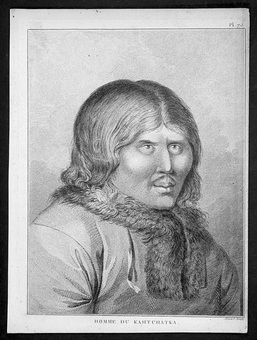
1785 Capt. Cook Antique Print of a Man of Kamchatka Peninsula East Russia, 1779
- Title : Homme Du Kamtchatka
- Ref : 31798
- Size: 10in x 8in (255mm x 205mm)
- Date : 1785
- Condition: (A+) Fine Condition
Description:
This fine original copper-plate engraved antique print of a man of the Kamchatka Peninsula in Eastern Russia, drawn during a visit by Captain Clerke in 1779 (after Cooks death) during Captain Cooks 3rd and last Voyage of Discovery, was engraved by Robert Benard - after Cooks on-board artist, John Webber - and was published in the 1785 French edition of Capt. James Cook & Capt. James King A Voyage to the Pacific Ocean. Undertaken, by the Command of his Majesty, for making Discoveries in the Northern Hemisphere. To determine The Position and Extent of the West Side of North America; its Distance from Asia; and the Practicability of a Northen Passage to Europe. Performed under the direction of Captains Cook, Clerke, and Gore, In His Majesty\'s Ships the Resolution and Discovery. In the Years 1776, 1777, 1778, 1779, and 1780. In Three Volumes. Vol. I and II written by James Cook, F.R.S. Vol. III by Captain James King, LL.D. and F.R.S. Paris, 1785.
General Definitions:
Paper thickness and quality: - Heavy and stable
Paper color : - off white
Age of map color: -
Colors used: -
General color appearance: -
Paper size: - 10in x 8in (255mm x 205mm)
Plate size: - 9 1/2in x 7 1/4in (240mm x 185mm)
Margins: - Min 1/2in (12mm)
Imperfections:
Margins: - Light soiling in margins
Plate area: - None
Verso: - None
Background:
The Kamchatka Peninsula is a 1,250-kilometre-long peninsula in the Russian Far East.
After the death of James Cook in early 1779, Captain Charles Clerke took control of Cooks 3rd Voyage of Discovery. Clerke, who was dying of tuberculosis, sailed north of Hawaii, landing on the Kamchatka peninsula where the Russians helped him with supplies and to make repairs to the ships. He made a final attempt to pass beyond the Bering Strait and died on his return at Petropavlovsk on 22 August 1779. From here the ships\' reports were sent overland, reaching London five months later. Following the death of Clerke, Resolution and Discovery turned for home commanded by John Gore, a veteran of Cook\'s first voyage (and now in command of the expedition), and James King. After passing down the coast of Japan they reached Macao, in China in the first week of December and from there followed the East India trade route via Sunda Strait to Cape Town
Captain James King FRS 1750 – 1784 was an officer of the Royal Navy. He served under James Cook on his last voyage around the world, specialising in taking important astronomical readings using a sextant. After Cook died he helped lead the ships on the remainder of their course, also completing Cook\\\'s account of the voyage. He continued his career in the Navy, reaching the rank of post-captain, commanding several ships and serving in the American War of Independence.
King joined HMS Resolution as second lieutenant, sharing the duties of astronomer with Cook, taking astronomical observations on board by sextant and with Larcum Kendals timekeeper K1, to establish the Resolutions position at sea and on shore by sextant or by astronomical quadrant to establish the geographical position of salient points during the course of Cooks surveys. Thus King\\\'s geographical positions were an important contribution to the accuracy of the various surveys carried out during the voyage and his use of the early chronometers helped prove their use at sea for calculation of Longitude. .
Following the death of Cook, King remained in the Resolution but on the death of Charles Clerke, Cooks successor, King was appointed to command HMS Discovery, the Resolution\\\'s consort, remaining in her for the rest of the voyage. After his return to England King was very much involved in the publication of the official account of Cooks third voyage, writing the third volume at Woodstock, near Oxford, where his brother Thomas was rector of St Mary Magdalene. But shortly after his return King was promoted Post-captain and appointed commander of HMS Crocodile in the English Channel.
John Webber RA 1751 – 1793 was an English artist who accompanied Captain Cook on his third Pacific expedition. He is best known for his images of Australasia, Hawaii and Alaska.
Webber was born in London, educated in Bern and studied painting at Paris.His father was Abraham Wäber, a Swiss sculptor who had moved to London, and changed his name to Webber before marrying a Mrs Mary Quant in 1744.
Webber served as official artist on James Cook\'s third voyage of discovery around the Pacific (1776–80) aboard HMS Resolution. At Adventure Bay in January 1777 he did drawings of A Man of Van Diemens Land and A Woman of Van Diemens Land. He also did many drawings of scenes in New Zealand and the South Sea islands. On this voyage, during which Cook lost his life in a fight in Hawaii, Webber became the first European artist to make contact with Hawaii, then called the Sandwich Islands. He made numerous watercolor landscapes of the islands of Kauai and Hawaii, and also portrayed many of the Hawaiian people.
In April 1778, Captain Cooks ships Resolution and Discovery anchored at Ship Cove, now known as Nootka Sound, Vancouver Island, Canada to refit. The crew took observations and recorded encounters with the local people. Webber made watercolour landscapes including Resolution and Discovery in Ship Cove, 1778. His drawings and paintings were engraved for British Admiraltys account of the expedition, which was published in 1784.
Back in England in 1780 Webber exhibited around 50 works at Royal Academy exhibitions between 1784 and 1792, and was elected an associate of the Royal Academy in 1785 and R.A. in 1791. Most of his work were landscapes. Sometimes figures were included as in A Party from H.M.S. Resolution shooting sea horses\", which was shown at the academy in 1784, and his The Death of Captain Cook became well known through an engraving of it. Another version of this picture is in the William Dixson gallery at Sydney
Robert Bénard 1734 – 1777 was an 18th-century French engraver.
Specialized in the technique of engraving, Robert Ménard is mainly famous for having supplied a significant amount of plates (at least 1,800) to the Encyclopédie by Diderot & d\'Alembert from 1751.
Later, publisher Charles-Joseph Panckoucke reused many of his productions to illustrate the works of his catalog.


