 Alvin Jewett Johnson (1827 - 1884)
Profile :
Alvin Jewett Johnson (1827-1884) was an American map publisher, cartographer, and businessman. He was born on September 23, 1827, in Wallingford, Vermont, and started his career as a teacher. Later, he moved to Richmond, Virginia, and became a bookseller and publisher. In 1856, he founded his own map publishing company, A.J. Johnson & Company, which would go on to become one of the most successful map publishers of the 19th century.
Johnson's maps were highly accurate, detailed, and beautifully designed, which made them very popular with the public. He used the latest surveying techniques and information to create maps that were up-to-date and reliable. He also employed talented engravers and artists to create decorative elements for his maps, such as borders, vignettes, and illustrations.
Some of Johnson's most famous works include his "Johnson's New Illustrated (Steel Plate) Family Atlas," which was published in 1862 and contained over 200 maps, as well as his "Johnson's World Atlas," which was first published in 1860 and contained over 60 maps. He also published individual state and city maps, as well as maps of other countries and regions around the world.
Johnson's maps were popular not only in the United States but also in Europe and other parts of the world. His company continued to publish maps and atlases even after his death in 1884, and it was eventually bought out by the publishing giant, Rand McNally, in the early 20th century. Today, Johnson's maps are highly collectible and continue to be admired for their accuracy, beauty, and historical significance.
Alvin Jewett Johnson (1)
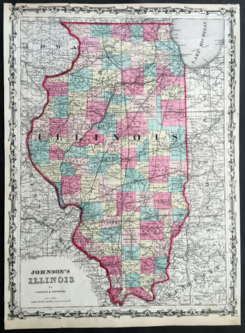
1860 A J Johnson Large Antique 1st edition Map of The State of Illinois, USA
- Title : Johnson's Illinois by Johnson & Browning
- Ref #: 50671
- Size: 17 1/2in x 13in (450mm x 330mm)
- Date : 1860
- Condition: (A) Very Good Condition
Description:
This finely engraved beautifully hand coloured original 1st edition map of the State of Illinois was published by A J Johnson in the 1860 edition ofJohnson's New Illustrated Family Atlas.
Background:
1st Edition, 1st issue. Most of the maps in this atlas come from Colton's 1859 edition of the General Atlas, published by Johnson and Browning, indicating the Johnson connection; some do not come from this atlas, and their sources are: the New England maps (scale 1" = 9 miles) come from Colton's map of New England and then the sub-maps of Vermont and New Hampshire, Mass/Conn/R.I.; the Ohio/Indiana is still a mystery; all the 1" = 24 miles maps (Iowa, Kentucky, etc.) come from Colton's Map of the United States and the Canadas, originally published by J. Calvin Smith in 1843 (see W. Heckrotte's copies and his list of editions); and the Colton General Atlas maps used by Johnson come from Colton's Travellers Series of maps - see our copies of Penn., Indiana. Colton mentions "The National Atlas of the United States, constructed from the Public Surveys..large Folio" as in preparation in his 1855 catalogue; this may be the embryonic Johnson Atlas. Colton used his wall maps "cut up" for pocket maps and Atlases. Johnson's maps of S. America, Europe, Africa, and (in the first edition, first issue, only) China, East Indies etc., all come from D. Griffing Johnson's Map of the World, 1847. These atlas maps are updated (esp. Africa). Colton took over the publication of the World Map in 1849, issued editions to 1868 (Ristow p318). Also, Johnson's N. America map is the inset N. America in Smith's Map of the U.S., the Canadas, etc. This first issue of Johnson's Family Atlas differs from the later 1860 edition in a small N.Y. (from the Colton U.S. map), small Texas, and many of the maps have fewer views or no views or different configurations. Clearly, this was a first attempt that was refined later in the year. Another issue of this same edition was published in Richmond, Virginia, the home town of Browning (I.L.). The California map originates with Johnson's New Illustrated and Embellished County
General Description:
Paper thickness and quality: - Heavy & stable
Paper color: - White
Age of map color: - Original
Colors used: - Pink green yellow
General color appearance: - Authentic
Paper size: - 17 1/2in x 13in (450mm x 330mm)
Plate size: - 17 1/2in x 13in (450mm x 330mm)
Margins: - Min 1/4in 312mm)
Imperfections:
Margins: - Uniform age toning, light chipping to margin edges
Plate area: - None
Verso: - Uniform age toning