Profile : Abraham Ortel, better known as Abraham Ortelius, was a Flemish cartographer and geographer, widely regarded as one of the greatest cartographers of his time. Born in Antwerp, Belgium, Ortelius was interested in geography and cartography from a young age. He initially worked as a map colorist before eventually establishing his own publishing house and becoming one of the leading cartographers of the 16th century.
Ortelius is best known for his atlas, "Theatrum Orbis Terrarum" ("Theatre of the World"), which was first published in 1570 and became one of the most influential works in the history of cartography. The atlas contained a collection of maps that were accurate, detailed, and beautifully designed, making it popular among scholars, explorers, and merchants.
In addition to his cartographic work, Ortelius was also an avid collector of maps, books, and manuscripts. He traveled extensively throughout Europe, visiting libraries and meeting with other cartographers and geographers to exchange information and ideas.
Ortelius received numerous honors and accolades during his lifetime, including being appointed geographer to the king of Spain and being elected a member of the prestigious Antwerp Guild of St. Luke. Today, his contributions to the field of cartography are still celebrated, and his maps and atlases are highly prized by collectors and scholars alike.
1570 – 1612
Theatrum Orbis Terrarum Between these years the Theatrum was re-issued in 42 editions with 5 supplements with text in Latin, Dutch, German, French, Spanish, Italian and English. The English edition was published in 1606 by John Norton, the maps being printed in Antwerp and the text added in London. Three years after Ortelius died in 1598, his heirs transferred publication rights to Jan Baptiste Vrients who produced the later editions until he died in 1612
1577 - 85
Spiegel der Werelt (8vo) Maps from the Theatrum, reduced in size, engraved by Philip Galle: text by Pieter Heyns. 6 editions with Dutch, French and Latin text. 1588-i 603 Epitome theatri orbis terrarum (12mo/8v0) 11 further editions of the smaller maps with an increasing number of maps with text also in Italian and English (1603). i6oi-i 2 7 further editions with improved engravings by Arsenius Brothers: text by Michel Coignet in Latin, French, German, Italian and English (1603).
1598 - 1724
Theatro del Mondo (4t0/12mo/24mo) 8 editions with Italian text; plates engraved in Italy. 1579-1606 Parergon Theatri The number of maps included in the Parergon increased from 4 in 1579 to 43 in 1606 with text in Latin, French, Italian, German and English (1606) 1624 Re-issued in Antwerp as a separate publication by Balthasar Moretus. This edition included a reproduction of the Peutinger table
Abraham Ortelius (1)
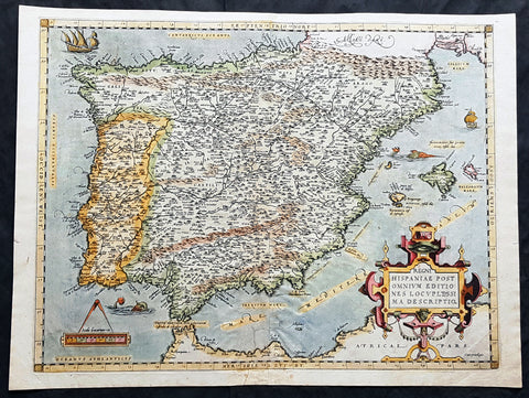
1574 Abraham Ortelius Antique Map of Spain & Portugal - Regni Hispaniae
- Title : Regni Hispaniae Post Omnium Editiones Locvplessima Descriptio
- Ref #: 82078
- Size: 21 1/2in x 16in (545mm x 405mm)
- Date : 1574
- Condition: (A) Very Good Condition
Description:
This beautifully hand coloured original antique map of Spain & Portugal, 1st edition - based on the cartographic work of Charles de L Escluse - was published by Abraham Ortelius in the 1574 Latin edition of Theatrum Orbis Terrarum.
Ortelius published a total of 8175 of this map between 1570 to 1641 in 4 States. According to Marcel Van den Broecke there are estimated to be only 155 loose copies in circulation today.
General Definitions:
Paper thickness and quality: - Heavy and stable
Paper color : - off white
Age of map color: - Early
Colors used: - Yellow, green, blue, pink
General color appearance: - Authentic
Paper size: - 21 1/2in x 16in (545mm x 405mm)
Plate size: - 19 1/2in x 15in (495mm x 380mm)
Margins: - Min 1in (25mm)
Imperfections:
Margins: - Small repair to bottom margin
Plate area: - Small repair adjacent to bottom centerfold, no loss
Verso: - Centerfold re-enforced on verso
Background:
Many of the original charts and maps drawn by the first Portuguese and Spanish navigators have survived for the very good reason that, on completion of their voyages, pilots were obliged to hand over their manuscript notes to the Casa da India (founded 1504) in Lisbon or to the equivalent Casa de Contrataci6n de las Indias (founded 1504) in Seville. The clear intention was to maintain secrecy over new discoveries and control over the distribution of cartographic material, not always successfully, as it happened; pilots and navigators seem to have changed allegiance with impunity and, in consequence, many of the earliest and most informative charts were compiled as far away as Genoa, Venice, Florence and Ancona, presumably from sources outside the Portuguese and Spanish \'Casas\'.It is apparent that few manuscripts reached the printing stage and, indeed, are so rare that any study of them must be regarded as a specialist subject. (Ref Tooley M&B)

