Recent Acquisitions (295)
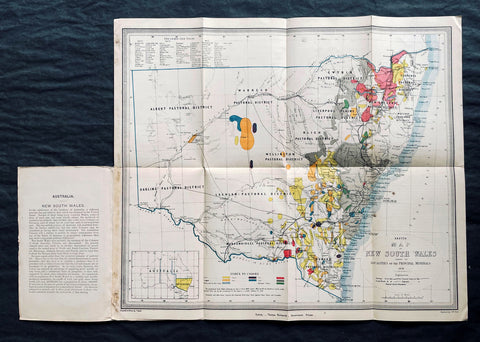
1876 Thomas & Tayler Scarce Antique Goldfields & Minerals Map of New South Wales
- Title : Sketch Map of New South Wales showing the Localities of the Principal Minerals 1876
- Ref #: 27011
-
Condition: (A+) Fine Condition
- Size: 18in x 15 1/2in (455mm x 400mm)
- Date : 1876
Description:
This original, incredibly scarce & important, antique lithograph map of New South Wales, illustrating the location of the Principle Minerals of that state, was drawn by John Tayler, engraved by G W Sharp and published by Thomas Richards in 1876 - dated, Sydney
General Definitions:
Paper thickness and quality: - Heavy and stable
Paper color : - off white
Age of map color: - Original
Colors used: - Yellow, green, blue, pink
General color appearance: - Authentic
Paper size: - 18in x 15 1/2in (455mm x 400mm)
Plate size: - 18in x 15 1/2in (455mm x 400mm)
Margins: - Min 1/2in (12mm)
Imperfections:
Margins: - Folds as issued
Plate area: - Folds as issued
Verso: - Folds as issued
Background:
The map shows New South Wales' new (and current) boundaries, with the state's 'Pastoral Districts' delineated; railways from Ports Hunter and Jackson are shown, along with their proposed extensions inland. Roads and telegraph lines are also indicated. Relief is shown by hachure. An inset map in the lower left shows the state's location on the Australian continent. These features are shared by the authors' other maps of New South Wales, the 1871 Map of New South Wales and the 1878 Sketch map of New South Wales showing the principal agricultural districts. Specific to this map, areas printed in color show the regions understood to be rich in minerals: Kerosene shale, coal, tin, iron, silver, copper, gold and 'diamonds and other gems.' The data on the map reflects the experience of some twenty years of prospecting in New South Wales, but predate the first systematic geological survey of the state, which would not be completed until 1880. The map specifies that the gold fields are 'proclaimed' gold fields, that is to say, permissible for prospectors. No prospector's claim was valid unless it fell within the limits of a 'proclaimed' field, which was officially recognized by the state and administered by a commissioner. The earlier 1873 edition of this map distinguishes between 'proclaimed' and 'unproclaimed' fields; in the present edition, the 'unproclaimed' fields have disappeared entirely. By 1876, control of gold mining in the state had passed from the Department of Lands to a new administration, the Department of Mines; in conjunction with this, mining had become less of a prospector-driven, 'gold rush' affair and more the province of mining companies employing more sophisticated processes, capable of extracting wealth from existing claims in which lower-capitalized operations were ineffective.
John Tayler 1861 - 1875 was an Australian cartographer and draftsman, employed by the NSW Surveyor Generals Office. His 1871 Map of New South Wales appears to have provided the basis for the bulk of the maps of the state produced prior to the Geological survey of 1880.
Richards, Thomas (1831 - 1898)
Thomas Richards, government printer, was born on 21 December 1831 in Pitt Street, Sydney, son of James Richards, builder, and his wife Mary, née OBrien. He was baptized a Catholic. His parents died in his infancy and he was reared by his aunt, the daughter of a sergeant-major in the First Fleet, and educated at Ebenezer on the Hawkesbury River. Having answered an advertisement for an intelligent youth, on 1 January 1845 he was engaged as an apprentice in the Government Printing Office, where he advanced as clerk, proof-reader, compositor, pressman, overseer and, in 1854, superintendent. In June 1859 he became government printer and inspector of stamps at a salary of £500, which had been reduced from his predecessors £850, but was raised to £600 in 1863; he had a staff of seventy. As he lacked London experience his appointment was unpopular. From 1 July 1879 he was also registrar of copyright.
During Richardss innovative administration, with increasing volume of work, the office expanded its functions and techniques. In 1863 he introduced photo-lithography and, after he had observed plant in Victoria in 1864, he added stereo-typing and electro-typing. In 1868 following the establishment of extra branches a new fast process of photo-lithography was invented by John Sharkey whose experiments were encouraged and assisted by Richards. The Sydney Morning Herald praised the gems of photo-lithographic art the Printing Office displayed at the 1870 Intercolonial Exhibition at Sydney. Later Richards initiated helio-type or photo-mechanical printing, introduced a perforating machine and invented a method of drying stamps with heat from gas. He devised an arithmotype bars system for numbering debentures which was adopted in all the colonies and England; he alleged the Bank of England took the patent without acknowledgment.
Frequently working long hours, Richards was criticized by some politicians for his administration and his publication of documents of allegedly limited public interest. He defended himself adequately before the 1870 select committee on the Government Printing Office, resisting suggestions of reductions in salaries and praising his men for the finest examples of the modern technique of photo-lithography seen in the colonies; and he admitted ambitions to produce an Australian geography and natural history, a year-book and dictionary of names for New South Wales. Looking back in 1891 he wrote, I had opposed to me a truculent minister, a truculent under-secretary and a truculent newspaper proprietor … I beat them but came out of the fray wounded in mind body and estate. He also had trouble with trade unions in difficult industrial times for heads of government departments and in 1875 antagonized the Trades and Labor Council by threatening to close the Office against all union men.
In 1877 Richards represented the government on an English committee to celebrate the quatercentenary of Caxtons introduction of printing. With twelve months leave he also studied advanced methods and bought new machinery. At the 1878 Paris Universal Exhibition he won a silver and two bronze medals and at the 1880 Melbourne International Exhibition he won five high diplomas for printing, bookbinding and photography. The 1883 Amsterdam Exhibition awarded him a gold and a silver medal, and the Printing Office was commended at other important exhibitions from 1862 to 1886. In 1882 Richards compiled, edited and printed the highly regarded New South Wales in 1881, which was translated into French; next year the office produced An Epitome of the Official History of New South Wales.
On 23 April 1861 Richards had joined the Volunteer Rifles as a second lieutenant. A good shot and member of the New South Wales Rifle Association, in 1885 he became lieutenant-colonel of the first regiment, Volunteer Infantry; he resigned next year. In November 1886, because of rapidly failing eyesight, Richards retired as government printer on a pension of £480; he left a staff of 400 and an office with sixty-one new departments. On 31 August 1898 he died at Manly and was buried in the Anglican cemetery there. On 29 January 1865, with Anglican rites, he had married Zara Bell, by whom he had three daughters and two sons who survived him.
Please note all items auctioned are genuine, we do not sell reproductions. A Certificate of Authenticity (COA) can be issued on request.
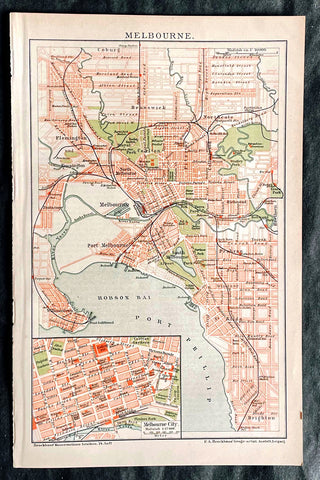
1896 F.A. Brockhaus Antique Map, Street Plan of Melbourne, Victoria, Australia
- Title : Melbourne
- Ref #: 27012
-
Condition: (A+) Fine Condition
- Size: 10in x 6 1/2in (255mm x 165mm)
- Date : 1896
Description:
This original antique lithograph street map of Melbourne Australia was engraved and published F.A. Brockhaus for the Brockhaus Konversations Lexikon, Germany, 1896
General Definitions:
Paper thickness and quality: - Heavy and stable
Paper color : - off white
Age of map color: - Original
Colors used: - Yellow, green, blue, pink
General color appearance: - Authentic
Paper size: - 10in x 6 1/2in (255mm x 165mm)
Plate size: - 10in x 6 1/2in (255mm x 165mm)
Margins: - Min 1/2in (12mm)
Imperfections:
Margins: - None
Plate area: - None
Verso: - None
Brockhaus, Friedrich Arnold (1772 - 1823)
Friedrich Arnold Brockhaus was a German encyclopedia publisher and editor, famed for publishing the Conversations-Lexikon, which is now published as the Brockhaus encyclopedia.
Brockhaus was educated at the gymnasium of his native Dortmund, and from 1788 to 1793 served an apprenticeship in a mercantile house at Düsseldorf. He then devoted two years at the University of Leipzig to the study of modern languages and literature, after which he set up in Dortmund an emporium for English goods. In 1801, he transferred this business to Arnheim, and in the following year to Amsterdam.
In 1805, having given up his first line of trade, Brockhaus began business as a publisher. Two journals projected by him were not allowed by the government to survive for any length of time, and in 1810 the complications in the affairs of Holland induced him to return homewards. In 1811 he settled at Altenburg. About three years previously he had purchased the copyright of the bankrupt Conversations-Lexikon, an encyclopedia started in 1796, and in 1810-1811 he completed the first edition of this celebrated work. It was widely imitated as a model for encyclopedias, and is still published today, known as the Brockhaus Encyclopedia.
A second edition under Brockhauss editorship was begun in 1812, and was received with universal favour. His business extended rapidly, and in 1818 Brockhaus moved to Leipzig, where he established a large printing-house. Among the more extensive of his many literary undertakings were the critical periodicals — Hermes, the Literarisches Konversationsblatt (afterwards the Blätter für literarische Unterhaltung) and the Zeilgenossen, and some large historical and bibliographical works, such as Friedrich Ludwig Georg von Raumers Geschichte der Hohenstaufen, and Friedrich Adolf Eberts Allgemeines bibliographisches Lexikon.
Brockhaus died in Leipzig. The business was carried on by his sons, Friedrich Brockhaus (1800–1865), who retired in 1850, and Heinrich Brockhaus (1804–1874), under whom it was considerably extended. Heinrich especially rendered great services to literature and science, which the University of Jena recognized by making him, in 1858, honorary Doctor of Philosophy. In the years 1842–1848, Heinrich Brockhaus was member of the Saxon second chamber, as representative for Leipzig, was made honorary citizen of that city in 1872, and died there on 15 November 1874.
His firm continues under the name F.A. Brockhaus AG in his honor. He is also the namesake of 27765 Brockhaus, a main-belt asteroid discovered in 1991.
Please note all items auctioned are genuine, we do not sell reproductions. A Certificate of Authenticity (COA) can be issued on request.
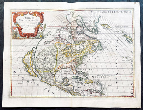
1687 Giovanni Giacomo de Rossi Large Antique Map of North America
- Title : L America Settentrionale....Guglielmo Sansone...Gio Giacomo De Rossi in Roma l Anno 1687
- Size: 23 1/2in x 18in (595mm x 455mm)
- Condition: (AVery Good Condition
- Date : 1687
- Ref #: 17061
Description:
This original hand coloured copper-plate engraved antique map of North America was engraved in 1687 by Giorgio Widman and was published by Giovanni Giacomo de Rossi in the 1688 edition of Atlas Mercurio Geografico
Giorgio Widman (active 1672 to 1682) was a celebrated map and lettering engraver, who worked primiparity with the De Rossi publishing house. He is perhaps best known for having executed the lettering of Giovanni Battista Faldas superb 1675 map of Rome.
General Definitions:
Paper thickness and quality: - Heavy and stable
Paper color : - off white
Age of map color: - Original & later
Colors used: - Yellow, green, blue, pink
General color appearance: - Authentic
Paper size: - 23 1/2in x 18in (595mm x 455mm)
Plate size: - 22in x 16in (560mm x 405mm)
Margins: - Min 1in (25mm)
Imperfections:
Margins: - Small nick to left bottom margin
Plate area: - Light creasing, top centerfold rejoined
Verso: - Light soiling
Background:
Attractive map of North America, with California depicted as an island. This is the Italian edition of the 1669 revised edition of Nicolas Sansons 1650 map. This is the third state of De Rossi s map, dated 1687 (after the first in 1677), with the addition of place names and other features, i.e. a coastline added from Agubela de Cato northward, Stretto d ANIAN named at 60 deg. N., MARE DI CALIFORNIA named to the west of California, and with many internal features added above 45 deg. N. Describing the first state, McLaughlin notes California with indented northern coast, with nothing to west and Agubela de Cato to north. Among the place names are C. de Mendocino, Pta. de los Reyes, Pta. de Monte Rey, Pta. de Francisco Draco (south of Pta de Monte Rey), Canal de S. Barbara, I. de S. Catalina, P. de S. Diego, etc. In the southwest, there is a large lake near Taosii, with R. de Norte flowing southwest from it to the Mar Rosso.
de Rossi, Giovanni Giacomo (1627 – 1691)
De Rossi was an Italian engraver and printer, active in Rome in the second half of the 17th century.
His father, Giuseppe de Rossi (1570-1639), was the founder of the most important and active printing press of the 17th century in Rome. The printing press begun in 1633, by Giuseppe de Rossi, and it passed firstly to Giovanni Giacomo and to his brother Giandomenico (1619-1653), and then later to Lorenzo Filippo (1682-?); in 1738 it became the Calcografia Camerale, from 1870 until 1945 the Regia Calcografica, and today it is known as the Calcografia Nazionale. Here are conserved, amongst many others, the plates of Giambattista Piranesi (1720-1778).
Giovanni Giacomo de Rossi was the most involved of all the various family members who ran the press, and he worked between 1638 and 1691, and was to take the company to the height of its success. The artists that he printed the etchings for included Giovanni Benedetto Castiglione (1609-1665), Pietro Testa (1612-1650) and Giovan Francesco Grimaldi (1606–1680).
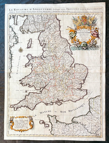
1693 Alexis Hubert Jaillot Large 1st Edition Antique Map of England & Wales
- Title : Le Royaume d'Angleterre Distingue en Ses Provinces...1693
- Size: 33in x 24in (840m x 610mm)
- Condition: (A+) Fine Condition
- Date : 1693
- Ref #: 17059
Description:
This large beautifully hand coloured original 1693 1st edition antique map of England & Wales by A H Jaillot - after Nicolas Sanson - was engraved in 1693 - the date is engraved in the title and was published by Jaillot in his large elephant folio Atlas Nouveau.
An original first state of this handsome map of England and Wales, that includes the east coast of Ireland's, southern Scotland, the Channel Islands, and a stretch of French coastline south to Paris. England and Wales are divided into their local counties, with highly detailed information on towns, cities, rivers, and topographical information.
The stunning decorative title cartouche features the United Kingdom coat-of-arms with a banner underneath reading Je Maintiendray ("I will maintain," which is strangely enough the motto of the Netherlands), along with trumpeting angels, mermen, and symbols of military might. A second cartouche flanked by putti encloses the six distance scales. A compass rose capped with a fleur-de-lis appears in the Irish Sea. Jaillot, in partnership with the sons of Nicolas Sanson, re-engraved Nicolas's Sanson's map on a larger scale in the 1680's. This particular map was published a few years later in the 1690's, and while based on Sanson's cartography (who is credited in the cartouche), it is a Jaillot composition. Also included is an alternate title running along the top neatline: Le Royaume d'Angleterre, Distingue en Ses Provinces; Scavoir en Northumberland, Mercie, East-Angles, Essex, Kent, Sussex, West-Sex, et la Principaute de Galles.
General Definitions:
Paper thickness and quality: - Heavy and stable
Paper color : - off white
Age of map color: - Original & later
Colors used: - Yellow, green, blue, pink
General color appearance: - Authentic
Paper size: - 33in x 24in (840m x 610mm)
Plate size: - 31 1/4in x 23in (795mm x 585mm)
Margins: - Min 1in (25mm)
Imperfections:
Margins: - None
Plate area: - None
Verso: - None
Background:
English Cartography: When considering the work of English map makers we tend, perhaps, to think too much in terms of county maps, dominated by the names of Saxton and Speed, but we should not underrate the contribution to the sum of geographical knowledge made in other spheres, such as the sea charts of Edward Wright, Robert Dudley and Greenvile Collins, the discoveries of James Cook, the road maps of Ogilby and Cary, the meteorological and magnetic charts compiled by Edmund Halley, to mention only a few.
In 1558 Queen Elizabeth came to the throne in the midst of a fast changing world. In 1563 a nineteen sheet map, copies of which survive only in manuscript form, was completed by Laurence Nowell, and no doubt, the issue of Mercator's large-scale map of the British Isles in 1564 had an important influence on the thought of the period. A few years later a national survey was commissioned privately, although probably at the instigation of Lord Burghley, the Lord Treasurer, but subsequently was completed with royal encouragement. The outcome was Christopher Saxton's Atlas of EngIand and Wales, started about 1570 and published in 1579 - the first printed set of county maps and the first countrywide atlas on such a splendid scale produced anywhere. A Welsh antiquarian, Humphrey Lhuyd completed a set of surveys that were even more successful than Saxton in which he had produced fine manuscript maps of England and Wales which were used by Ortelius in editions of his Atlas from 1573 onwards.
The earliest maps of the 17th century, attributed to William Smith of the College of Heralds, covered only twelve counties based on Saxton/Norden and were presumably intended to be part of a complete new atlas. They were printed in the Low Countries in 1602-3 and were soon followed by maps for the Latin edition of Camden's Britannia dated 1607. In 1610-11 the first edition of John Speed's famous county Atlas The Theatre of the Empire of Great Britaine was published and immediately replaced Saxton's in popular appeal. Although Speed assembled much of his material from the earlier works of Saxton, Norden and others, a considerable part of the up-to-date information, especially relating to the inset town plans depicted on his maps, was obtained first hand. The maps undoubtedly owed much of their popularity to the splendid engravings of high quality made in the workshops in Amsterdam of Jodocus Hondius to whom Speed sent his manuscripts, the plates subsequently being returned to London for printing.
In 1645, Volume IV of the famous Blaeu World Atlas covering the counties of England and Wales was published in Amsterdam. These maps have always been esteemed as superb examples of engraving and design, the calligraphy being particularly splendid, but nevertheless they were nearly all based on Saxton and Speed and added little to geographical knowledge.
Not until the latter part of the century do we find an English map maker of originality with the capacity to put new ideas into practice. John Ogilby, one of the more colourful figures associated with cartography, started life as a dancing master and finished as King's Cosmographer and Geographic Printer. After publishing a small number of county maps, somewhat on the lines of John Norden he issued in 1675 the Britannia, the first practical series of detailed maps of the post roads of England and Wales on a standard scale of 1,760 yards to the mile. Up to the end of the century and beyond, reprints and revisions of Saxton's and Speed's atlases continued to appear and the only other noteworthy county maps were Richard Blome's Britannia (1673), John Overton's Atlas (c. 1670) and Robert Morden's maps for an English translation of Camden's Britannia published in 1695.
Another noted cartographer of the day was Captain Greenvile Collins, and of his work in surveying the coasts of Great Britain culminating in the issue in 1693 of the Great Britain's Coasting Pilot. Apart from these charts, English cartographers published during the century a number of world atlases. Speed was the first Englishman to produce a world atlas with the issue in 1627 of his A Prospect of the Most Famous Parts of the World. Other atlases appeared later in the century by Peter Heylin, John Seller, William Berry, Moses Pitt and Richard Blome, whilst Ogilby found time to issue maps of Africa, America and Asia. Far more important, from the purely scientific point of view, was the work of Edmund Halley, Astronomer Royal, who compiled and issued meteorological and magnetic charts in 1688 and 1701 respectively.
At the beginning of the eighteenth century the Dutch map trade was finally in decline, the French in the ascendant and the English to a great extent still dominated by Saxton and Speed except, as we have shown, in the spheres of sea charts and road maps. There were atlases by John Senex, the Bowles family, Emanuel and Thomas Bowen, Thomas Badeslade and the unique bird's-eye perspective views of the counties, The British Monarchy by George Bickham. In 1750-60 Bowen and Kitchin's The Large English Atlas containing maps on a rather larger scale than hitherto was published.
In 1759 the Society for the encouragement of Arts, Manufactures and Commerce offered an award of £100 for the best original surveys on this scale and by the end of the century about thirty counties had been re-surveyed. These maps, many of which formed, in later years, the basis for the first issues of county maps by the Ordnance Survey Office were not only decorative but a tremendous improvement geographically on earlier local maps. As a consequence, the skills and expertise of the new-style cartographers soon enabled them to cover the world as well as the domestic market. Thomas Jefferys was such a man; he was responsible for a number of the new 1 in. to 1 mile county surveys and he issued an edition of Saxton's much battered 200-year-old plates of the county maps, but he is better known for many fine maps of North America and the West Indies. His work was continued on the same lines by William Faden, trading as Faden and Jefferys. Other publishers such as Sayer and Bennett and their successors Laurie and Whittle published a prodigious range of maps, charts and atlases in the second half of the century. A major influence at this time was John Cary who, apart from organizing the first re-survey of post roads since Ogilby and subsequently printing the noted Travellers' Companion, was a prolific publisher of atlases and maps of every kind of all parts of the world. After starting work with Cary, and taking part in the new road survey, Aaron Arrowsmith set up in his own business and went on to issue splendid large-scale maps of many parts of the world. Both Cary's and Arrowsmith's plates were used by other publishers until far into the next century and, in turn, their work was taken up and developed by James Wyld (Elder and Younger) and Tallis and Co.
Later into the 19th century some of the better known cartographers and publishers were by Henry Teesdale (1829-30), Christopher and John Greenwood, surveyors, Thomas Moule, a writer on heraldry and antiques (1830-36) and John Walker (1837) but by about the middle of the century few small-scale publishers survived and their business passed into the hands of large commercial concerns such as Bartholomews of Edinburgh and Philips of London who continue to this day. (Ref: Shirley; Tooley; M&B)
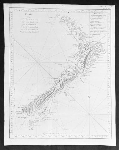
1774 Captain James Cook Antique Map, 1st Printed Chart of New Zealand
- Title : Carte de la Nle. Zelande visitée en 1769 et 1770 par le Lieutenant J. Cook Commandant de l'Endeavour vasseau de sa Majesté.
- Date : 1774
- Size: 20 1/2in x 16 1/2in (520mm x 420mm)
- Condition: (A) Very Good Condition
- Ref: 27004
Description:
This magnificent large original copper plate engraved scarce antique map, the first printed chart of New Zealand by Captain James Cook, during his circumnavigation of New Zealand in 1769-70, was published in the 1st French edition of Hawkeworths Voyages in 1774.
General Definitions:
Paper thickness and quality: - Heavy and stable
Paper color : - off white
Age of map color: -
Colors used: -
General color appearance: -
Paper size: - 20 1/2in x 16 1/2in (520mm x 420mm)
Plate size: - 19 1/4in x 15 1/2in (490mm x 394mm)
Margins: - Min 1/2in (12mm)
Imperfections:
Margins: - Folds as issued
Plate area: - Folds as issued, professional restoration of tear to center of map, no loss
Verso: - Folds as issued, professional restoration of tear to center of map, no loss
Background:
The first printed chart of New Zealand.
New Zealand (or Aotearoa, as the Maori call it) had been first encountered by Europeans in the early 1640s, when Dutch explorer Abel Tasman named the land Nieuw Zeeland after the Dutch province. Importantly, Tasman only sailed up the west coast of the North Island and had little notion as to the nature of the islands or their broader geographical context. A small number of Tasman\\\'s place names were preserved by Cook (and remain in place to this day), including \\\'Cape Maria van Diemen\\\' (the northernmost point of the North Island) and the \\\'Three Kings\\\' islets, where Cook and his men celebrated the Christmas of 1769-the first Europeans to visit the islands for nearly 130 years.
Captain James Cook (1728-1779) is considered to be the greatest explorer of the eighteenth century and was the finest maritime cartographer of the Age of Enlightenment. Having first worked on coal colliers and then distinguished himself as a surveyor in Eastern Canada, in 1768 he became the British Admiralty\\\'s choice to lead an unprecedented voyage of discovery. The central impetus for the expedition was to observe the Transit of Venus from Tahiti and then to proceed to explore Terra Australis Incognita, the supposedly rich southern continent. Whereas the first part of the voyage was to be conducted under the auspices of international scientific cooperation, the second part was entirely clandestine and was only communicated to Cook via Secret Instructions to be opened once at sea.
Cook\\\'s party left Plymouth in August 1768 aboard the converted coal collier HMS Endeavor and proceeded to Tahiti by way of Cape Horn. They arrived in time to observe the Transit of Venus, which occurred June 3, 1769. Cook then proceeded towards New Zealand, to the coordinates recorded by Tasman. As New Zealand was quite conceivably part of Terra Australis, it was Cook\\\'s intention to carefully explore and map the region.
On October 6, 1769, the Endeavor sighted the North Island (Te Ika a Maui) at Turanga Nui, which Cook renamed Poverty Bay. He and his crew had arrived on the opposite shore to where Tasman had met the island. Cook proceeded to the South Island (Te Wai Pounamu), carefully mapping both landmasses with a running survey. He used soundings, visual observations, and triangulation regulated by astronomical observations to create his manuscript charts.
Despite being constantly buffeted by wind and rain, and after having some hostile relations with the Maori that resulted in Maori deaths, Cook and his crew managed to circumnavigate both the North and South Islands, proving that they were separate islands divided by the Cook Strait. They also proved the islands were not connected to any southern continent. On March 31, 1770, Cook wrote in his journal that the Endeavour\\\'s voyage:
…must be allowed to have set a side the most, if not all, the arguments and proofs that have been advanced by different Authors to prove that there must be a Southern Continent; I mean to the northward of 40 degrees South, for what may lay to the Southward of that Latitude I know not (Cook, Journals I, 290).
The Endeavor left New Zealand at Cape Farewell, sailing west towards Australia, where Cook\\\'s crew would become the first Europeans to explore that region. In total, they had surveyed over 2,400 miles of New Zealand coastline in six months.
Upon the Endeavour\\\'s return to England in July 1771, Cook became a national hero. He would go on to lead two further voyages that would succeed in illuminating most of the Pacific Ocean to European eyes. On the second expedition, Cook would put to rest the myth of a southern continent. On the third, he kick started the fur trade in the Pacific Northwest of North America while searching for the Northwest Passage. He was killed by Hawaiians at Kealakekua Bay in 1779.
The first printed chart of New Zealand.
New Zealand (or Aotearoa, as the Maori call it) had been first encountered by Europeans in the early 1640s, when Dutch explorer Abel Tasman named the land Nieuw Zeeland after the Dutch province. Importantly, Tasman only sailed up the west coast of the North Island and had little notion as to the nature of the islands or their broader geographical context. A small number of Tasmans place names were preserved by Cook (and remain in place to this day), including Cape Maria van Diemen (the northernmost point of the North Island) and the Three Kings islets, where Cook and his men celebrated the Christmas of 1769-the first Europeans to visit the islands for nearly 130 years.
Captain James Cook (1728-1779) is considered to be the greatest explorer of the eighteenth century and was the finest maritime cartographer of the Age of Enlightenment. Having first worked on coal colliers and then distinguished himself as a surveyor in Eastern Canada, in 1768 he became the British Admiraltys choice to lead an unprecedented voyage of discovery. The central impetus for the expedition was to observe the Transit of Venus from Tahiti and then to proceed to explore Terra Australis Incognita, the supposedly rich southern continent. Whereas the first part of the voyage was to be conducted under the auspices of international scientific cooperation, the second part was entirely clandestine and was only communicated to Cook via Secret Instructions to be opened once at sea.
Cooks party left Plymouth in August 1768 aboard the converted coal collier HMS Endeavor and proceeded to Tahiti by way of Cape Horn. They arrived in time to observe the Transit of Venus, which occurred June 3, 1769. Cook then proceeded towards New Zealand, to the coordinates recorded by Tasman. As New Zealand was quite conceivably part of Terra Australis, it was Cooks intention to carefully explore and map the region.
On October 6, 1769, the Endeavor sighted the North Island (Te Ika a Maui) at Turanga Nui, which Cook renamed Poverty Bay. He and his crew had arrived on the opposite shore to where Tasman had met the island. Cook proceeded to the South Island (Te Wai Pounamu), carefully mapping both landmasses with a running survey. He used soundings, visual observations, and triangulation regulated by astronomical observations to create his manuscript charts.
Despite being constantly buffeted by wind and rain, and after having some hostile relations with the Maori that resulted in Maori deaths, Cook and his crew managed to circumnavigate both the North and South Islands, proving that they were separate islands divided by the Cook Strait. They also proved the islands were not connected to any southern continent. On March 31, 1770, Cook wrote in his journal that the Endeavours voyage:
…must be allowed to have set a side the most, if not all, the arguments and proofs that have been advanced by different Authors to prove that there must be a Southern Continent; I mean to the northward of 40 degrees South, for what may lay to the Southward of that Latitude I know not (Cook, Journals I, 290).
The Endeavor left New Zealand at Cape Farewell, sailing west towards Australia, where Cooks crew would become the first Europeans to explore that region. In total, they had surveyed over 2,400 miles of New Zealand coastline in six months.
Upon the Endeavours return to England in July 1771, Cook became a national hero. He would go on to lead two further voyages that would succeed in illuminating most of the Pacific Ocean to European eyes. On the second expedition, Cook would put to rest the myth of a southern continent. On the third, he kick started the fur trade in the Pacific Northwest of North America while searching for the Northwest Passage. He was killed by Hawaiians at Kealakekua Bay in 1779.
The chart and its publication
Cook returned to England with over 300 manuscript charts and coastal views. The original manuscript chart of New Zealand is now held by the British Library (Add MS 7085, f. 16-7). The chart was drawn, at least in part, by Isaac Smith (1752-1831), a draftsman of considerable skill who worked with Cook in Newfoundland, sailed on the Endeavour and Cooks second voyage, and was related to Cooks wife. Of the New Zealand chart, Cook wrote:
The Chart which I have drawn will best point out the figure and extent of these Islands…beginning at Cape Palliser and proceed round Aehei no mouwe (North Island) by the East Cape &ca. The Coast between these two Capes I believe to be laid down pretty accurate both in its figure and the Course and distance from point to point. The oppertunities I had and the methods I made use on to obtain these requesites were such as could hardly admit of an error… some few places however must be excepted and these are very doubtfull …(Cook, Journals I, 275-6)
The overall delineation is impressively accurate, correctly capturing many of the bays and promontories, and making insightful observations of the interior. Many of the names given by Cook survive to this day, including the Alps, (the great mountain chain of the South Island), Mount Egmont (the volcano on the North Island, also known as Mount Taranaki), the Bay of Islands, the Bay of Plenty, Hawkes Bay, and most intriguingly, Cape Kidnappers (a point on the North Island where Maori warriors attempted to abduct a member of the Endeavors crew).
There are a few errors, conspicuous only because of the otherwise superb accuracy of the chart. Notably, Cooks Bankes Island is in fact a peninsula, part of the South Island. Further south, what looks like a possible peninsula is actually Stewart Island, with the Isle Solander to the west. Also, some portions of coast line remain un-surveyed due to adverse conditions or distraction. For example, the portion of coastline near Bankes Island is but a dotted line because Lieutenant Gore had thought he sighted land to the southeast. Upon sailing toward it, the promontory proved to be clouds. Despite such mistakes, the chart is remarkably thorough.
The present chart was printed as part of the official account of Cooks first voyage, which was edited by the literary critic John Hawkesworth and underwritten by the British Admiralty. An Account of the Voyages undertaken by the order of His Present Majesty for making Discoveries in the Southern Hemisphere… (London: W. Strahan and T. Cadell, 1773) recounted the voyages not only of Cook, but of Byron, Wallis, and Carteret who had also ventured to the Pacific for the Royal Navy earlier in the 1760s. It was engraved by John Abraham Bayly (fl. 1755-1794), a London-based engraver who specialized in cartographic work.
In 1816, the British Hydrographic Office began to reprint the map for its vessels. The chart was continuously consulted into the twentieth century. Due to this longevity, its extraordinary origins, and its important place in the founding of New Zealand as a British colony, Cooks chart is considered to be the most important single map in the history of New Zealand. Due to the complexity of the assignment and the great accuracy of the survey, it is also considered to be one of Cooks very finest maps, and one of the truly great achievements of Enlightenment cartography.
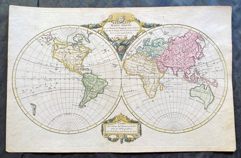
1780 Robert De Vaugondy Antique Twin Hemisphere World Map
- Title : Mappe-Monde par Robert de Vaugondy Geographe ord du Roi
- Size: 17 1/2in x 11 1/2in (440mm x 290mm)
- Condition: (A+) Fine Condition
- Date : 1780
- Ref #: 17060
Description:
This beautifully hand coloured original copper-plate engraved antique Twin Hemisphere World Map by Robert De Vaugondy was engraved in 1780 - dated in title and published in the same year.
General Definitions:
Paper thickness and quality: - Heavy and stable
Paper color : - off white
Age of map color: - Original
Colors used: - Yellow, green, blue, pink
General color appearance: - Authentic
Paper size: - 17 1/2in x 11 1/2in (440mm x 290mm)
Plate size: - 17 1/2in x 11 1/2in (440mm x 290mm)
Margins: - Min 1/2in (12mm)
Imperfections:
Margins: - None
Plate area: - None
Verso: - None
Background:
Fine twin hemisphere world map illustrating the known world in the 18th century. Although almost complete there are a few regions of uncertainty. The route taken by Cook on his final voyage is included which reaches from Australia, New Zealand to Hawaii and the very northern reaches of western North America which were surveyed and mapped by Cook extensively. There is some indication of a northern Arctic region there is no mention of the great southern Antarctica regions. A great map showing the world at the beginning of modern era. (Ref: Tooley; M&B)
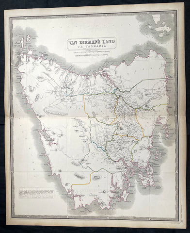
1856 A K Johnston Large Antique Map of Van Diemens Land or Tasmania, Australia
- Title : Van Diemens Land or Tasmania by A K Johnston
- Date : 1856
- Condition: (A+) Fine Condition
- Ref: 27002
- Size: 25in x 21 1/2in (635mm x 545mm)
This original large hand coloured steel plate engraved antique map was published by A K Johnston in the 1856 edition of his National atlas of historical, commercial, and political geography.
General Definitions:
Paper thickness and quality: - Heavy and stable
Paper color : - off white
Age of map color: - Original
Colors used: - Yellow, green, blue, pink
General color appearance: - Authentic
Paper size: - 25in x 21 1/2in (635mm x 545mm)
Plate size: - 25in x 21 1/2in (635mm x 545mm)
Margins: - Min 1/2in (12mm)
Imperfections:
Margins: - Light age toning
Plate area: - Light age toning
Verso: - Light age toning
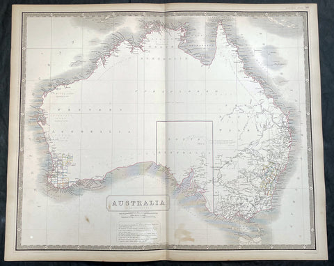
1856 A K Johnston Large Antique Map of Australia, early Separation of Victoria
- Title : Australia by A K Johnston
- Date : 1856
- Condition: (A+) Fine Condition
- Ref: 27000
- Size: 25in x 21 1/2in (635mm x 545mm)
Description:
This original large hand coloured steel plate engraved antique map of Australia - with coloured outlines to the counties in NSW & WA - was published by A K Johnston in the 1856 edition of his National atlas of historical, commercial, and political geography.
A important and interesting map illustrating the boundary of South Australia, as well as the county boundaries in both Western Australia and New South Wales. One of the first maps to illustrate the separation of the state of Victoria from New South Wales in 1851.
General Definitions:
Paper thickness and quality: - Heavy and stable
Paper color : - off white
Age of map color: - Original
Colors used: - Yellow, green, blue, pink
General color appearance: - Authentic
Paper size: - 25in x 21 1/2in (635mm x 545mm)
Plate size: - 25in x 21 1/2in (635mm x 545mm)
Margins: - Min 1/2in (12mm)
Imperfections:
Margins: - Light age toning
Plate area: - Light age toning
Verso: - Light age toning
Background:
Australia is a sovereign country comprising the mainland of the Australian continent, the island of Tasmania and numerous smaller islands. It is the largest country in Oceania and the world\\\'s sixth-largest country by total area. The neighbouring countries are Papua New Guinea, Indonesia and East Timor to the north; the Solomon Islands and Vanuatu to the north-east; and New Zealand to the south-east. The population of 25 million is highly urbanised and heavily concentrated on the eastern seaboard. Australias capital is Canberra, and its largest city is Sydney. The country\\\'s other major metropolitan areas are Melbourne, Brisbane, Perth and Adelaide.
Australia was inhabited by indigenous Australians for about 60,000 years before the first British settlement in the late 18th century. It is documented that Aborigines spoke languages that can be classified into about 250 groups. After the European discovery of the continent by Dutch explorers in 1606, who named it New Holland, Australia\\\'s eastern half was claimed by Great Britain in 1770 and initially settled through penal transportation to the colony of New South Wales from 26 January 1788, a date which became Australia\\\'s national day. The population grew steadily in subsequent decades, and by the 1850s most of the continent had been explored and an additional five self-governing crown colonies established. On 1 January 1901, the six colonies federated, forming the Commonwealth of Australia. Australia has since maintained a stable liberal democratic political system that functions as a federal parliamentary constitutional monarchy comprising six states and ten territories.
Being the oldest, flattest and driest inhabited continent, with the least fertile soils, Australia has a landmass of 7,617,930 square kilometres. A megadiverse country, its size gives it a wide variety of landscapes, with deserts in the centre, tropical rainforests in the north-east and mountain ranges in the south-east. A gold rush began in Australia in the early 1850s, which boosted the population of the country. Nevertheless, its population density, 2.8 inhabitants per square kilometre, remains among the lowest in the world. Australia generates its income from various sources including mining-related exports, telecommunications, banking and manufacturing. Indigenous Australian rock art is the oldest and richest in the world, dating as far back as 60,000 years and spread across hundreds of thousands of sites.
The first recorded European sighting of the Australian mainland, and the first recorded European landfall on the Australian continent (in 1606), are attributed to the Dutch. The first ship and crew to chart the Australian coast and meet with Aboriginal people was the Duyfken captained by Dutch navigator, Willem Janszoon. He sighted the coast of Cape York Peninsula in early 1606, and made landfall on 26 February at the Pennefather River near the modern town of Weipa on Cape York. The Dutch charted the whole of the western and northern coastlines and named the island continent New Holland during the 17th century, but made no attempt at settlement. William Dampier, an English explorer and privateer, landed on the north-west coast of New Holland in 1688 and again in 1699 on a return trip. In 1770, James Cook sailed along and mapped the east coast, which he named New South Wales and claimed for Great Britain.
With the loss of its American colonies in 1783, the British Government sent a fleet of ships, the First Fleet, under the command of Captain Arthur Phillip, to establish a new penal colony in New South Wales. A camp was set up and the flag raised at Sydney Cove, Port Jackson, on 26 January 1788, a date which became Australia\\\'s national day, Australia Day. A British settlement was established in Van Diemens Land, now known as Tasmania, in 1803, and it became a separate colony in 1825. The United Kingdom formally claimed the western part of Western Australia (the Swan River Colony) in 1828. Separate colonies were carved from parts of New South Wales: South Australia in 1836, Victoria in 1851, and Queensland in 1859. The Northern Territory was founded in 1911 when it was excised from South Australia. South Australia was founded as a free province—it was never a penal colony. Victoria and Western Australia were also founded free, but later accepted transported convicts. A campaign by the settlers of New South Wales led to the end of convict transportation to that colony; the last convict ship arrived in 1848.
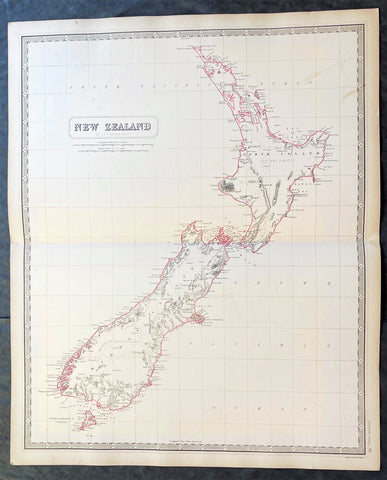
1856 A K Johnston Large Antique Map of New Zealand
- Title : New Zealand by A K Johnston
- Date : 1856
- Condition: (A+) Fine Condition
- Ref: 27003
- Size: 25in x 21 1/2in (635mm x 545mm)
Description:
This original large hand coloured steel plate engraved antique map of New Zealand was published by A K Johnston in the 1856 edition of his National atlas of historical, commercial, and political geography.
General Definitions:
Paper thickness and quality: - Heavy and stable
Paper color : - off white
Age of map color: - Original
Colors used: - Yellow, green, blue, pink
General color appearance: - Authentic
Paper size: - 25in x 21 1/2in (635mm x 545mm)
Plate size: - 25in x 21 1/2in (635mm x 545mm)
Margins: - Min 1/2in (12mm)
Imperfections:
Margins: - Light age toning
Plate area: - Light age toning
Verso: - Light age toning
Background:
The first printed chart of New Zealand.
New Zealand (or Aotearoa, as the Maori call it) had been first encountered by Europeans in the early 1640s, when Dutch explorer Abel Tasman named the land Nieuw Zeeland after the Dutch province. Importantly, Tasman only sailed up the west coast of the North Island and had little notion as to the nature of the islands or their broader geographical context. A small number of Tasmans place names were preserved by Cook (and remain in place to this day), including Cape Maria van Diemen (the northernmost point of the North Island) and the Three Kings islets, where Cook and his men celebrated the Christmas of 1769-the first Europeans to visit the islands for nearly 130 years.
Captain James Cook (1728-1779) is considered to be the greatest explorer of the eighteenth century and was the finest maritime cartographer of the Age of Enlightenment. Having first worked on coal colliers and then distinguished himself as a surveyor in Eastern Canada, in 1768 he became the British Admiraltys choice to lead an unprecedented voyage of discovery. The central impetus for the expedition was to observe the Transit of Venus from Tahiti and then to proceed to explore Terra Australis Incognita, the supposedly rich southern continent. Whereas the first part of the voyage was to be conducted under the auspices of international scientific cooperation, the second part was entirely clandestine and was only communicated to Cook via Secret Instructions to be opened once at sea.
Cooks party left Plymouth in August 1768 aboard the converted coal collier HMS Endeavor and proceeded to Tahiti by way of Cape Horn. They arrived in time to observe the Transit of Venus, which occurred June 3, 1769. Cook then proceeded towards New Zealand, to the coordinates recorded by Tasman. As New Zealand was quite conceivably part of Terra Australis, it was Cooks intention to carefully explore and map the region.
On October 6, 1769, the Endeavor sighted the North Island (Te Ika a Maui) at Turanga Nui, which Cook renamed Poverty Bay. He and his crew had arrived on the opposite shore to where Tasman had met the island. Cook proceeded to the South Island (Te Wai Pounamu), carefully mapping both landmasses with a running survey. He used soundings, visual observations, and triangulation regulated by astronomical observations to create his manuscript charts.
Despite being constantly buffeted by wind and rain, and after having some hostile relations with the Maori that resulted in Maori deaths, Cook and his crew managed to circumnavigate both the North and South Islands, proving that they were separate islands divided by the Cook Strait. They also proved the islands were not connected to any southern continent. On March 31, 1770, Cook wrote in his journal that the Endeavours voyage:
…must be allowed to have set a side the most, if not all, the arguments and proofs that have been advanced by different Authors to prove that there must be a Southern Continent; I mean to the northward of 40 degrees South, for what may lay to the Southward of that Latitude I know not (Cook, Journals I, 290).
The Endeavor left New Zealand at Cape Farewell, sailing west towards Australia, where Cooks crew would become the first Europeans to explore that region. In total, they had surveyed over 2,400 miles of New Zealand coastline in six months.
Upon the Endeavours return to England in July 1771, Cook became a national hero. He would go on to lead two further voyages that would succeed in illuminating most of the Pacific Ocean to European eyes. On the second expedition, Cook would put to rest the myth of a southern continent. On the third, he kick started the fur trade in the Pacific Northwest of North America while searching for the Northwest Passage. He was killed by Hawaiians at Kealakekua Bay in 1779.
The chart and its publication
Cook returned to England with over 300 manuscript charts and coastal views. The original manuscript chart of New Zealand is now held by the British Library (Add MS 7085, f. 16-7). The chart was drawn, at least in part, by Isaac Smith (1752-1831), a draftsman of considerable skill who worked with Cook in Newfoundland, sailed on the Endeavour and Cooks second voyage, and was related to Cooks wife. Of the New Zealand chart, Cook wrote:
The Chart which I have drawn will best point out the figure and extent of these Islands…beginning at Cape Palliser and proceed round Aehei no mouwe (North Island) by the East Cape &ca. The Coast between these two Capes I believe to be laid down pretty accurate both in its figure and the Course and distance from point to point. The oppertunities I had and the methods I made use on to obtain these requesites were such as could hardly admit of an error… some few places however must be excepted and these are very doubtfull …(Cook, Journals I, 275-6)
The overall delineation is impressively accurate, correctly capturing many of the bays and promontories, and making insightful observations of the interior. Many of the names given by Cook survive to this day, including the Alps, (the great mountain chain of the South Island), Mount Egmont (the volcano on the North Island, also known as Mount Taranaki), the Bay of Islands, the Bay of Plenty, Hawkes Bay, and most intriguingly, Cape Kidnappers (a point on the North Island where Maori warriors attempted to abduct a member of the Endeavors crew).
There are a few errors, conspicuous only because of the otherwise superb accuracy of the chart. Notably, Cooks Bankes Island is in fact a peninsula, part of the South Island. Further south, what looks like a possible peninsula is actually Stewart Island, with the Isle Solander to the west. Also, some portions of coast line remain un-surveyed due to adverse conditions or distraction. For example, the portion of coastline near Bankes Island is but a dotted line because Lieutenant Gore had thought he sighted land to the southeast. Upon sailing toward it, the promontory proved to be clouds. Despite such mistakes, the chart is remarkably thorough.
The present chart was printed as part of the official account of Cooks first voyage, which was edited by the literary critic John Hawkesworth and underwritten by the British Admiralty. An Account of the Voyages undertaken by the order of His Present Majesty for making Discoveries in the Southern Hemisphere… (London: W. Strahan and T. Cadell, 1773) recounted the voyages not only of Cook, but of Byron, Wallis, and Carteret who had also ventured to the Pacific for the Royal Navy earlier in the 1760s. It was engraved by John Abraham Bayly (fl. 1755-1794), a London-based engraver who specialized in cartographic work.
In 1816, the British Hydrographic Office began to reprint the map for its vessels. The chart was continuously consulted into the twentieth century. Due to this longevity, its extraordinary origins, and its important place in the founding of New Zealand as a British colony, Cooks chart is considered to be the most important single map in the history of New Zealand. Due to the complexity of the assignment and the great accuracy of the survey, it is also considered to be one of Cooks very finest maps, and one of the truly great achievements of Enlightenment cartography.
1882 Edward Stanford Large Folding Antique Map Eastern Australia, QLD, NSW, Vic
- Title : Queensland & New South Wales....London Published by Edward Stanford ...March 20th 1882
- Ref : 17064
- Size: 26 1/2in x 22in (680mm x 570mm)
- Date : 1882.
- Condition: (A+) Fine Condition
Description:
This large original hand coloured folding canvas backed antique map of Vicoria, New South Wales & Queensland in Eastern Australia, illustrating Tracks of Travellers, Roads, Railways & Telegraph was published by Edward Stanford, London in 1882, dated at the foot of the map. (Ref: Tooley; M&B)
General Definitions:
Paper thickness and quality: - Heavy and stable
Paper color : - off white
Age of map color: - Original
Colors used: - Blue, yellow, red, green
General color appearance: - Authentic
Paper size: - 26 1/2in x 22in (680mm x 570mm)
Plate size: - 26 1/2in x 22in (680mm x 570mm)
Margins: - Min 1/2in (12mm)
Imperfections:
Margins: - None
Plate area: - None
Verso: - None
Stanford, Edward 1827-1904
Stanford was a prominent British mapmaker and publisher. A native of Holborn in the heart of London, Edward was apprenticed to a printer and stationer at the age of 14. After his first master died, he worked with several others, including Trelawny W. Saunders of Charing Cross. Saunders oversaw young Edward’s early career, ensuring that he became a Fellow of the Royal Geographical Society. Associations with the Society eventually brought Sanders much business and gave him a reputation as a publisher of explorers. As testament to this reputation, the Stanford Range in British Columbia was named for him by John Palliser.
Stanford briefly partnered with Saunders in 1852 before striking out on his own in 1853. He was an agent for the Ordnance Survey, the Admiralty, the Geological Survey, the Trigonometrical Survey of India, and the India Office. He also controlled the maps of the Society for the Diffusion of Useful Knowledge, another lucrative source of income. In 1857, Stanford founded his namesake Geographical Establishment, with Saunders and A. K. Johnston as engravers. Thereafter, Stanford was known for his library maps, particularly those of Africa and Asia.
Although he had authored many maps, the Harrow Atlas of Modern Geography and a similar volume on classical geography, Stanford is better remembered today as the leader of a successful map business. Ever in search of more inventory, he acquired the plates and stock of John Arrowsmith, heir of the Arrowmsith family firm, in 1874. By 1881 he employed 87 people at his premises at 6 Charing Cross Road, Saunders’ old address. As he aged, he phased in his son Edward Jr. to run the business. He died in 1904. The business survived him, and the Stanford’s shop is still a prominent London landmark today.
Stanford premises were located in the Strand, London from 1853 to 1884 and then Cockspur St from 1885 to 1901 locating to its present location in Covent Garden.
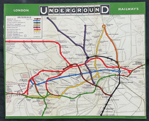
1908 UERL Johnson & Riddle Antique London Underground Map Rare 2nd Map Published
- Title : London Underground Railways
- Ref #: 17054
- Size: 13 3/4in x 11 1/2in (352mm x 290mm)
- Date : 1908
- Condition: (A+) Fine Condition
Description:
This original early scarce antique folding, pocket map of The London Underground, only the second combined map, by The Underground Electric Railways Company of London (UERL) was published by Johnson, Riddle & co. in 1908.
The first map was published a year earlier by The Evening News in 1907.
This geographic paper edition of the Underground map shows the Railway lines belonging to the Underground Group as well as the Central London Railway and Metropolitan Railway lines. Each line is represented by a different colour, other railways are marked with lighter black lines, London United tramways are shown by lines of crosses and other tramways routes are marked with a broken line. General geographic features such as roads and parks are also included. Earl's Court Exhibition Ground is marked on this map as well as the Franco-British Exhibition at Shepherd's Bush. This map has a green border and the UndergrounD logo is used in the map title.
General Definitions:
Paper thickness and quality: - Heavy and stable
Paper color : - off white
Age of map color: - Original
Colors used: - Yellow, green, blue, pink
General color appearance: - Authentic
Paper size: - 13 3/4in x 11 1/2in (352mm x 290mm)
Plate size: - 13 3/4in x 11 1/2in (352mm x 290mm)
Margins: - Min 1/8in (2mm)
Imperfections:
Margins: - Folds as issued
Plate area: - Folds as issued
Verso: - Folds as issued
Background:
As Londons early transport system was operated by a variety of independent companies, there were no complete maps of the network, just for the individual companies routes. The maps were not typically schematic and were simply the line overlaid on a regular city map. There was no integration of the companies services or any co-operation in advertising.
In 1907, The Evening News commissioned a pocket map, The Evening News London Tube Map. It was the first map to show all of the lines with equal weight being given to each line, and it was the first map to use a different colour for each line.
Another early combined map was published in 1908 by the Underground Electric Railways Company of London (UERL) in conjunction with four other underground railway companies that used the Underground brand as part of a common advertising factor.
The map showed eight routes – four operated by the UERL and one from each of the other four companies:
UERL lines:
Bakerloo Railway – brown
Hampstead Railway – indigo
Piccadilly Railway – yellow
District Railway – green
Other lines:
Central London Railway – blue
City and South London Railway – black
Great Northern and City Railway – orange
Metropolitan Railway – red
A geographical map presented restrictions since for sufficient clarity of detail in the crowded central area of the map required the extremities of the District and Metropolitan lines to be omitted and so a full network diagram was not provided. The problem of truncation remained for nearly half a century. Although all of the western branches of the District and Piccadilly lines were included for the first time in 1933 with Harry Becks first proper Tube map, the portion of the Metropolitan line beyond Rickmansworth did not appear until 1938, and the eastern end of the District line did not appear until the mid-1950s.
The route map continued to be developed and was issued in various formats and artistic styles until 1920, when, for the first time, the geographic background detail was omitted in a map designed by MacDonald Gill. That freed the design to enable greater flexibility in the positioning of lines and stations. The routes became more stylised but the arrangement remained, largely, geographic in nature. The 1932 edition was the last geographic map to be published before Becks diagrammatic map was introduced.
The first diagrammatic map of Londons rapid transit network was designed by Harry Beck in 1931. He was a London Underground employee who realised that because the railway ran mostly underground, the physical locations of the stations were largely irrelevant to the traveller wanting to know how to get from one station to another; only the topology of the route mattered. That approach is similar to that of electrical circuit diagrams although they were not the inspiration for Becks map. His colleagues pointed out the similarities, however, and he once produced a joke map with the stations replaced by electrical circuit symbols and names, with terminology such as Bakerlite for the Bakerloo line.
To that end, Beck devised a simplified map with stations, straight-line segments connecting them, and the River Thames; and lines running only vertically, horizontally, or on 45° diagonals. To make the map clearer and to emphasise connections, Beck differentiated between ordinary stations, marked with tick marks, and interchange stations, marked with diamonds. London Underground was initially sceptical of his proposal since it was an uncommissioned spare-time project and was tentatively introduced to the public in a small pamphlet in 1933. However, it immediately became popular, and the Underground has used topological maps to illustrate the network ever since.
Despite the complexity of making the map, Beck was paid just ten guineas for the artwork and design of the card edition (five guineas for the poster). After its initial success, he continued to design the Tube map until 1960, a single (and unpopular) 1939 edition by Hans Scheger being the only exception. Meanwhile, as well as accommodating new lines and stations, Beck continually altered the design, such as changing the interchange symbol from a diamond to a circle and altering the line colours of the Central line from orange to red and of the Bakerloo line from red to brown. Becks final design, in 1960, bears a strong resemblance to the current map. Beck lived in Finchley, North London, and one of his maps is still preserved on the southbound platform at Finchley Central station, on the Northern line.
In 1997, Becks importance was posthumously recognised, and as of 2021, this statement is printed on every Tube map: This diagram is an evolution of the original design conceived in 1931 by Harry Beck.
The Underground Electric Railways Company of London Limited (UERL)
The Underground Electric Railways Company of London Limited (UERL), known operationally as the Underground for much of its existence, was established in 1902. It was the holding company for the three deep-level tube underground railway lines opened in London during 1906 and 1907: the Baker Street and Waterloo Railway, the Charing Cross, Euston and Hampstead Railway and the Great Northern, Piccadilly and Brompton Railway. It was also the parent company from 1902 of the District Railway, which it electrified between 1903 and 1905. The UERL is a precursor of today's London Underground; its three tube lines form the central sections of today's Bakerloo, Northern and Piccadilly lines.
The UERL struggled financially in the first years after the opening of its lines and narrowly avoided bankruptcy in 1908 by restructuring its debt. A policy of expansion by acquisition was followed before World War I, so that the company came to operate the majority of the underground railway lines in and around London. It also controlled large bus and tram fleets, the profits from which subsidised the financially weaker railways. After the war, railway extensions took the UERL's services out into suburban areas to stimulate additional passenger numbers, so that, by the early 1930s, the company's lines stretched beyond the County of London and served destinations in Middlesex, Essex, Hertfordshire and Surrey.
In the 1920s, competition from small unregulated bus operators reduced the profitability of the road transport operations, leading the UERL's directors to seek government regulation. This led to the establishment of the London Passenger Transport Board in 1933, which absorbed the UERL and all of the independent and municipally operated railway, bus and tram services in the London area.
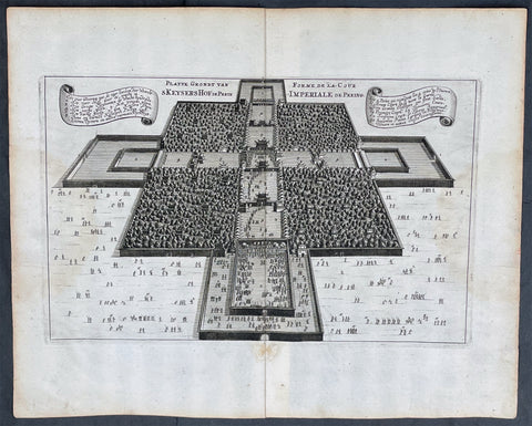
1665 Nieuhof Antique Print Imperial Palace Peking or the Forbidden City, Beijing
- Title : Platte Grondt van Skeyers Hof in Pekin; Forme de la Cour Imperiale de Peking
- Ref #: 17055
- Size: 15in x 12 1/2in (380mm x 310mm)
- Date : 1665
- Condition: (A+) Fine Condition
Description:
This original copper-plate engraved antique print a birds-eye view of the Imperial Palace & extensive gardens in Peking, now Beijing, or the Forbidden City by Johan Nieuhof was published by Jacob van Meurs in the 1665 edition of L’Ambassade de la Compagnie Orientale des Provinces Unies vers l’Empereur de la Chine, ou Grand Cam de Tartarie, faite par les sieurs Pierre de Goyer et Jacob de Keyser illustrée d’une très-exacte description des villes, bourgs, villages, ports de mer et autres lieux plus considérables de la Chine....1665. Title in English: An embassy from the East-India Company (1669).
General Definitions:
Paper thickness and quality: - Heavy and stable
Paper color : - off white
Age of map color: -
Colors used: -
General color appearance: -
Paper size: - 15in x 12 1/2in (380mm x 310mm)
Plate size: - 12 1/2in x 7 1/2in (310mm x 195mm)
Margins: - Min 1in (25mm)
Imperfections:
Margins: - None
Plate area: - None
Verso: - None
Background:
The Forbidden City is a palace complex in Dongcheng District, Beijing, China, at the center of the Imperial City of Beijing. It is surrounded by numerous opulent imperial gardens and temples including the 22-hectare Zhongshan Park, the sacrificial Imperial Ancestral Temple, the 69-hectare Beihai Park, and the 23-hectare Jingshan Park.
The Forbidden City was constructed from 1406 to 1420, and was the former Chinese imperial palace and winter residence of the Emperor of China from the Ming dynasty (since the Yongle Emperor) to the end of the Qing dynasty, between 1420 and 1924. The Forbidden City served as the home of Chinese emperors and their households and was the ceremonial and political center of the Chinese government for over 500 years. Since 1925, the Forbidden City has been under the charge of the Palace Museum, whose extensive collection of artwork and artifacts were built upon the imperial collections of the Ming and Qing dynasties. The Forbidden City was declared a World Heritage Site in 1987.
The complex consists of 980 buildings, encompassing 8,886 rooms and covering 720,000 square metres (72 hectares)/178 acres. The palace exemplifies the opulence of the residences of the Chinese emperor and the traditional Chinese palatial architecture, and has influenced cultural and architectural developments in East Asia and elsewhere. It is listed by UNESCO as the largest collection of preserved ancient wooden structures in the world. Since 2012, the Forbidden City has seen an average of 14 million visitors annually, and received more than 19 million visitors in 2019. In 2018, The Forbidden Citys market value has been estimated at US$70 billion, making it both the worlds most valuable palace and the most valuable piece of real estate anywhere in the world.
Some sources describe it as the largest palace in the world still in existence, but other Chinese imperial residences far exceed it in size, namely the 6.1 km2 (610 ha) Zhongnanhai which lies just west of the Forbidden City, the 2.9 km2 (290 ha) Summer Palace in Haidian District, Beijing, and the 5.6 km2 (560 ha) Chengde Mountain Resort in Chengde, Hebei Province.
The Forbidden City in Beijing is one of the largest and most well-preserved ancient wooden structures in the world. It is a national AAAAA-level tourist attraction in China. It was listed as the first batch of national key cultural relics in 1961 and listed as a world cultural heritage in 1987.
Nieuhof, Johan (1618 – 1672)
Nieuhof was a Dutch traveler who wrote about his journeys to Brazil, China and India. The most famous of these was a trip of 2,400 kilometers from Canton to Peking in 1655-1657, which enabled him to become an authoritative Western writer on China. He wrote An embassy from the East-India Company containing the written account of this journey.
Johan Nieuhof was born in Uelsen, a town in the county of Bentheim, Lower Saxony, sitting just across the Dutch-German border. His father (originally from Zwolle) was mayor of the town, and was later succeeded by one of Johans brothers and brother-in-law. By the grace of Cornelis Jan Witsen, a leading figure within the Dutch West India Company (or WIC), Nieuhof left for Dutch Brazil in 1640 as a reserve officer-candidate. From then on, barring two short family visits in 1658 and 1671, he spent all the rest of his life abroad.
Nieuhof was employed in Brazil to explore the regions between Maranhão and the São Francisco Rivers, made a particular study of the neighborhood of Pernambuco. He left Brazil in 1649, after the Portuguese victory in the Second Battle of Guararapes. Upon his return, Nieuhof joined the service of the Dutch East India Company (or VOC). In service of the VOC he resided several years in Batavia, and then was appointed in 1654 steward of an embassy to the relatively new Qing emperor China under Peter de Goyer and Jacob de Keyser, which aimed to gain trading rights on Chinas southern coast.
He remained in China until 1657. In 1663 he operated as an ambassador in Quilon, after the occupation of the Malabar Coast by Rijckloff van Goens. During this period he visited several chiefs of indigenous tribes in order to secure trade relations with them. Afterwards, he was offered a post on Ceylon where he was stationed between 1663 and 1667. He was imprisoned for seven months because of illegal trade in pearls. Nieuhof was sent to Batavia by Hendrik van Rheede and fired by the Dutch East India Company.
On returning to the Indies from a trip home in 1672, he stopped on the isle of Madagascar. On October 8 1672, Nieuhof traveled inland along with the first mate, in search of the local tribes in order to trade with them, as well as secure water for his crew. Upon hearing several gunshots, the captain sent a second ship towards the island in order to await Nieuhofs return. After three days of waiting, the captain presumed Nieuhof and his company to be murdered and sailed onwards towards Mauritius. On order of the governing council in Amsterdam, a ship was sent from the Cape of Good Hope to retrieve Nieuhof and his fellows, but no trace of them could be found.
In the first half of the 17th century, the VOC tried to break the Portuguese monopoly position on trade to Macau. When they did not succeed, they sent six embassies to Peking between 1655 and 1685. Their aim was to convince the Qing emperor to open up trade relations on the southern coast, in favor of the VOC, although they ultimately failed. Nieuhof was appointed to the position of steward on one of these embassies by Joan Maetsuycker, which traveled from Canton to Peking between 1655 and 1658. They were the second embassy to try and gain the emperors favor, the first was led by Zacharias Wagenaer. Nieuhofs duties as part of the embassy primarily consisted of ceremonial matters as well as securing lodgings. He was, however, specifically appointed to illustrate any and all of the cities, palaces, temples, rivers and other noteworthy buildings in their true to nature form.
On March 17 1656, after months of negotiations and discussions of tributes to be paid to the Chinese emperor and viceroy, the embassy left Canton by barge, to travel towards Peking. The embassy arrived at the emperors court in Peking on July 18 the same year. The hired the jesuit scholar Johann Adam Schall von Bell to be their translator, who warned them of the possible dangers and required ceremonies to approach the emperor. On September 24, the embassy was received by the Shunzhi Emperor. As dictated by their translator, the party performed the traditional kowtow, as failing to do so would most likely result in immediate refusal by the emperor. As a result, the emperor allowed Dutch embassies to visit the court once every eight years, in parties consisting of no more than 100 men. Any trading rights were not discussed nor granted at this point. On October 16 the embassy was asked to leave the city of Peking within two hours. Their return trip took three months; putting the entire length of the embassy at 20 months and 6 days.
At his homecoming in 1658, he had entrusted his notes and annotations to his brother Hendrik, whom Johan thanked when finally (in 1665) Hendrik produced an ample study of China, with many images, text and explanation of the latest events. The work was published by Jacob van Meurs in 1665, titled Het Gezandtschap der Neêrlandtsche Oost-Indische Compagnie, aan den grooten Tartarischen Cham, den tegenwoordigen Keizer van China: Waarin de gedenkwaerdigste Geschiedenissen, die onder het reizen door de Sineesche landtschappen, Quantung, Kiangsi, Nanking, Xantung en Peking, en aan het Keizerlijke Hof te Peking, sedert den jaren 1655 tot 1657 zijn voorgevallen, op het bondigste verhandelt worden. Beneffens een Naukeurige Beschrijvinge der Sineesche Steden, Dorpen, Regeering, Weetenschappen, Hantwerken, Zeden, Godsdiensten, Gebouwen, Drachten, Schepen, Bergen, Gewassen, Dieren, et cetera en oorlogen tegen de Tartar : verçiert men over de 150 afbeeltsels, nat leven in Sina getekent. Hendrik dedicated the work to Hendrik Spiegel and Cornelis Jan Witsen (Nicolaes Witsens father), administrators of the East and West India Companies respectively. Translations into French (1665), German (1666), Latin (1668) and English (1669) were also published, each going into at least two editions. More of Nieuhoffs material, on Chinese ships, appeared in Nicolaes Witsens Scheepsbouw (1671).
The reports from these embassies and the reports of the Jesuits formed the only reliable source of information on China available in Western Europe. As mentioned, being the purser of the VOC embassy to Peking, Johan Nieuhof in 1655 had special instructions to observe all farms, towns, palaces, rivers, ... [and other] buildings that he might pass by, drawing them in straight form and figure, as well as remains of the historical victory of the Tartars (Manchus) that brought an end to the reign of the Ming dynasty. The inclusion of approximately 150 illustrations in the book marked the first time that literature on China contained images that were true to nature. In previously published works, belonging to the imaginative fantastic tradition where fact and fiction were hardly discernible, the Chinese were depicted as creatures of fantasy. Nieuhofs illustrations, as opposed to these previous works, depicted the Chinese and their culture as they were observed by the illustrator himself, without fanciful additions.
The 150 illustrations of the Nieuhoffs book were one inspiration for chinoiserie, which became especially popular in the 18th century. Many artists and architects based their designs on the pictures in the book. The original drawings were rediscovered in 1984 in the collection of prince Roland Bonaparte, an anthropologist who collected material about Madagascar, Lapland and the Native Americans.
Publications:
- Johannes Nieuhof (1668), Legatio batavica ad magnum Tartariæ chamum Sungteium, modernum Sinæ imperatorem; Historiarum narratione, quæ legatis in provinciis Quantung, Kiangsi, Nanking, Xantung, Peking, & aula imperatoriâ ab anno 1665 ad annum 1657 obtigerunt ..., Amstelodami: Jacobum Meursium, OCLC 2134985, OL 23411529M
- Het gezantschap der Neêrlandtsche Oost-Indische Compagnie, aan den grooten Tartarischen Cham, den tegenwoordigen keizer van China : waar in de gedenkwaerdighste geschiedenissen, die onder het reizen door de Sineesche landtschappen, Quantung, Kiangsi, Nanking, Xantung en Peking, en aan het keizerlijke hof te Peking, sedert den jare 1655 tot 1657 zijn voorgevallen, op het bondigste verhandelt worden : befeffens een naukeurige Beschryving der Sineesche steden, dorpen, regeering, wetenschappen, hantwerken, zeden, godsdiensten, gebouwen, drachten, schepen, bergen, gewassen, dieren, &c. en oorlogen tegen de Tarters : verçiert men over de 150 afbeeltsels, nat leven in Sina getekent. Amsterdam: Jacob van Meurs, 1665. Title in English: An embassy from the East-India Company (1669).
- Zee- en Lant-Reise door verscheide Gewesten van Oostindien, behelzende veele zeldzaame en wonderlijke voorvallen en geschiedenissen. Beneffens een beschrijving van lantschappen, dieren, gewassen, draghten, zeden en godsdienst der inwoonders: En inzonderheit een wijtloopig verhael der Stad Batavia. Amsterdam: de Weduwe van Jacob van Meurs, 1682. Google books
- Gedenkweerdige Brasiliaense Zee- en Lant-Reise und Zee- en Lant-Reize door verscheide Gewesten van Oostindien. Amsterdam: de Weduwe van Jacob van Meurs, 1682.
1665 Johan Nieuhof Large Antique Print of Chinese Mounted Cavalry, Archery
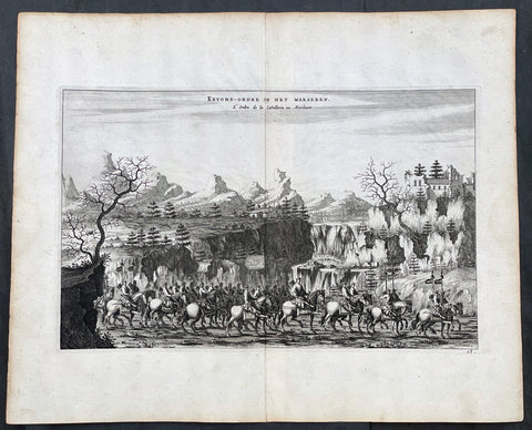
- Title : Kryghs-Ordre in Het Marseren; L Ordre de la Cavallerie en Marchant
- Ref #: 17056
- Size: 15in x 12 1/2in (380mm x 310mm)
- Date : 1665
- Condition: (A+) Fine Condition
Description:
This original copper-plate engraved antique print of Chinese Mounted Cavalry in formation by Johan Nieuhof was published by Jacob van Meurs in the 1665 edition of L’Ambassade de la Compagnie Orientale des Provinces Unies vers l’Empereur de la Chine, ou Grand Cam de Tartarie, faite par les sieurs Pierre de Goyer et Jacob de Keyser illustrée d’une très-exacte description des villes, bourgs, villages, ports de mer et autres lieux plus considérables de la Chine....1665. Title in English: An embassy from the East-India Company (1669).
General Definitions:
Paper thickness and quality: - Heavy and stable
Paper color : - off white
Age of map color: -
Colors used: -
General color appearance: -
Paper size: - 15in x 12 1/2in (380mm x 310mm)
Plate size: - 12 1/2in x 7 1/2in (310mm x 195mm)
Margins: - Min 1in (25mm)
Imperfections:
Margins: - None
Plate area: - None
Verso: - None
Background:
The vast, immediate success of the book which was published in Johan Nieuhof's name in 1665 in Dutch language was every publisher's dream. In this time and age, his report on his journey to China, compiled of the material he had sent to his brother, was a bestseller! In the 17th century alone, six Dutch editions were published. Within the same year of its release it was translated to French – the very same edition we have here – and shortly after it was also translated to German, Latin and English.
This huge interest in the book by the global public was not by chance! At the time, China was the dream country of every merchant and especially of every investor in Europe. China had the goods European markets were longing for. Firstly there was tea, but also the incredibly modern porcelain and the wonderfully soft silk. In addition, the spices and remedies from the Chinese market were promising great profit!
Since individual people of the 17th century could not finance successful trading companies of this size any longer, ambitious men had cooperated with the government and founded trading companies due to royal privileges. One can imagine a sort of incorporated company whose capital was provided by a market of investors. These resources were used to fit out fleets, establish local strongpoints and pay permanent employees whose work should bring investors great profit on their deposits.
The area called East India at the time was particularly popular for such investments. This wasn't just India and the Spice Islands, but also China and Japan. In 1600 the British founded their East India Company. In 1602 the Dutch East India Company followed, and Johan Nieuhof was allowed to accompany the imperial embassy. But other countries wanted to participate in the trade, too and founded companies: Denmark, Sweden, Portugal – and also France in 1665. Louis XIV had first privileged an East India Company on the initiative of his minister of finance Colbert, which competed for funds in 1665. Therefore Nieuhof's book was just in time!
What made Nieuhof's report especially interesting, were the 150 copper engravings that carried the reader off into the exotic worlds of the Far East. Nieuhof's book thus started the China-trend. There could be no rococo castle without a porcelain cabinet. No bourgeois household without chinoiseries. But Johan Nieuhof did not know which goods were desired by China in exchange. Consequently tea and silk had to be paid with silver. The negative trade balance was troubling to all European governments until the English had the delinquent idea to import opium on a large scale. It was only then that the trade balance turned around. But surely Johan Nieuhof cannot be made responsible for this.
Nieuhof, Johan (1618 – 1672)
Nieuhof was a Dutch traveler who wrote about his journeys to Brazil, China and India. The most famous of these was a trip of 2,400 kilometers from Canton to Peking in 1655-1657, which enabled him to become an authoritative Western writer on China. He wrote An embassy from the East-India Company containing the written account of this journey.
Johan Nieuhof was born in Uelsen, a town in the county of Bentheim, Lower Saxony, sitting just across the Dutch-German border. His father (originally from Zwolle) was mayor of the town, and was later succeeded by one of Johans brothers and brother-in-law. By the grace of Cornelis Jan Witsen, a leading figure within the Dutch West India Company (or WIC), Nieuhof left for Dutch Brazil in 1640 as a reserve officer-candidate. From then on, barring two short family visits in 1658 and 1671, he spent all the rest of his life abroad.
Nieuhof was employed in Brazil to explore the regions between Maranhão and the São Francisco Rivers, made a particular study of the neighborhood of Pernambuco. He left Brazil in 1649, after the Portuguese victory in the Second Battle of Guararapes. Upon his return, Nieuhof joined the service of the Dutch East India Company (or VOC). In service of the VOC he resided several years in Batavia, and then was appointed in 1654 steward of an embassy to the relatively new Qing emperor China under Peter de Goyer and Jacob de Keyser, which aimed to gain trading rights on Chinas southern coast.
He remained in China until 1657. In 1663 he operated as an ambassador in Quilon, after the occupation of the Malabar Coast by Rijckloff van Goens. During this period he visited several chiefs of indigenous tribes in order to secure trade relations with them. Afterwards, he was offered a post on Ceylon where he was stationed between 1663 and 1667. He was imprisoned for seven months because of illegal trade in pearls. Nieuhof was sent to Batavia by Hendrik van Rheede and fired by the Dutch East India Company.
On returning to the Indies from a trip home in 1672, he stopped on the isle of Madagascar. On October 8 1672, Nieuhof traveled inland along with the first mate, in search of the local tribes in order to trade with them, as well as secure water for his crew. Upon hearing several gunshots, the captain sent a second ship towards the island in order to await Nieuhofs return. After three days of waiting, the captain presumed Nieuhof and his company to be murdered and sailed onwards towards Mauritius. On order of the governing council in Amsterdam, a ship was sent from the Cape of Good Hope to retrieve Nieuhof and his fellows, but no trace of them could be found.
In the first half of the 17th century, the VOC tried to break the Portuguese monopoly position on trade to Macau. When they did not succeed, they sent six embassies to Peking between 1655 and 1685. Their aim was to convince the Qing emperor to open up trade relations on the southern coast, in favor of the VOC, although they ultimately failed. Nieuhof was appointed to the position of steward on one of these embassies by Joan Maetsuycker, which traveled from Canton to Peking between 1655 and 1658. They were the second embassy to try and gain the emperors favor, the first was led by Zacharias Wagenaer. Nieuhofs duties as part of the embassy primarily consisted of ceremonial matters as well as securing lodgings. He was, however, specifically appointed to illustrate any and all of the cities, palaces, temples, rivers and other noteworthy buildings in their true to nature form.
On March 17 1656, after months of negotiations and discussions of tributes to be paid to the Chinese emperor and viceroy, the embassy left Canton by barge, to travel towards Peking. The embassy arrived at the emperors court in Peking on July 18 the same year. The hired the jesuit scholar Johann Adam Schall von Bell to be their translator, who warned them of the possible dangers and required ceremonies to approach the emperor. On September 24, the embassy was received by the Shunzhi Emperor. As dictated by their translator, the party performed the traditional kowtow, as failing to do so would most likely result in immediate refusal by the emperor. As a result, the emperor allowed Dutch embassies to visit the court once every eight years, in parties consisting of no more than 100 men. Any trading rights were not discussed nor granted at this point. On October 16 the embassy was asked to leave the city of Peking within two hours. Their return trip took three months; putting the entire length of the embassy at 20 months and 6 days.
At his homecoming in 1658, he had entrusted his notes and annotations to his brother Hendrik, whom Johan thanked when finally (in 1665) Hendrik produced an ample study of China, with many images, text and explanation of the latest events. The work was published by Jacob van Meurs in 1665, titled Het Gezandtschap der Neêrlandtsche Oost-Indische Compagnie, aan den grooten Tartarischen Cham, den tegenwoordigen Keizer van China: Waarin de gedenkwaerdigste Geschiedenissen, die onder het reizen door de Sineesche landtschappen, Quantung, Kiangsi, Nanking, Xantung en Peking, en aan het Keizerlijke Hof te Peking, sedert den jaren 1655 tot 1657 zijn voorgevallen, op het bondigste verhandelt worden. Beneffens een Naukeurige Beschrijvinge der Sineesche Steden, Dorpen, Regeering, Weetenschappen, Hantwerken, Zeden, Godsdiensten, Gebouwen, Drachten, Schepen, Bergen, Gewassen, Dieren, et cetera en oorlogen tegen de Tartar : verçiert men over de 150 afbeeltsels, nat leven in Sina getekent. Hendrik dedicated the work to Hendrik Spiegel and Cornelis Jan Witsen (Nicolaes Witsens father), administrators of the East and West India Companies respectively. Translations into French (1665), German (1666), Latin (1668) and English (1669) were also published, each going into at least two editions. More of Nieuhoffs material, on Chinese ships, appeared in Nicolaes Witsens Scheepsbouw (1671).
The reports from these embassies and the reports of the Jesuits formed the only reliable source of information on China available in Western Europe. As mentioned, being the purser of the VOC embassy to Peking, Johan Nieuhof in 1655 had special instructions to observe all farms, towns, palaces, rivers, ... [and other] buildings that he might pass by, drawing them in straight form and figure, as well as remains of the historical victory of the Tartars (Manchus) that brought an end to the reign of the Ming dynasty. The inclusion of approximately 150 illustrations in the book marked the first time that literature on China contained images that were true to nature. In previously published works, belonging to the imaginative fantastic tradition where fact and fiction were hardly discernible, the Chinese were depicted as creatures of fantasy. Nieuhofs illustrations, as opposed to these previous works, depicted the Chinese and their culture as they were observed by the illustrator himself, without fanciful additions.
The 150 illustrations of the Nieuhoffs book were one inspiration for chinoiserie, which became especially popular in the 18th century. Many artists and architects based their designs on the pictures in the book. The original drawings were rediscovered in 1984 in the collection of prince Roland Bonaparte, an anthropologist who collected material about Madagascar, Lapland and the Native Americans.
Publications:
- Johannes Nieuhof (1668), Legatio batavica ad magnum Tartariæ chamum Sungteium, modernum Sinæ imperatorem; Historiarum narratione, quæ legatis in provinciis Quantung, Kiangsi, Nanking, Xantung, Peking, & aula imperatoriâ ab anno 1665 ad annum 1657 obtigerunt ..., Amstelodami: Jacobum Meursium, OCLC 2134985, OL 23411529M
- Het gezantschap der Neêrlandtsche Oost-Indische Compagnie, aan den grooten Tartarischen Cham, den tegenwoordigen keizer van China : waar in de gedenkwaerdighste geschiedenissen, die onder het reizen door de Sineesche landtschappen, Quantung, Kiangsi, Nanking, Xantung en Peking, en aan het keizerlijke hof te Peking, sedert den jare 1655 tot 1657 zijn voorgevallen, op het bondigste verhandelt worden : befeffens een naukeurige Beschryving der Sineesche steden, dorpen, regeering, wetenschappen, hantwerken, zeden, godsdiensten, gebouwen, drachten, schepen, bergen, gewassen, dieren, &c. en oorlogen tegen de Tarters : verçiert men over de 150 afbeeltsels, nat leven in Sina getekent. Amsterdam: Jacob van Meurs, 1665. Title in English: An embassy from the East-India Company (1669).
- Zee- en Lant-Reise door verscheide Gewesten van Oostindien, behelzende veele zeldzaame en wonderlijke voorvallen en geschiedenissen. Beneffens een beschrijving van lantschappen, dieren, gewassen, draghten, zeden en godsdienst der inwoonders: En inzonderheit een wijtloopig verhael der Stad Batavia. Amsterdam: de Weduwe van Jacob van Meurs, 1682. Google books
- Gedenkweerdige Brasiliaense Zee- en Lant-Reise und Zee- en Lant-Reize door verscheide Gewesten van Oostindien. Amsterdam: de Weduwe van Jacob van Meurs, 1682.
1719 H. Chatelain Large Antique Map of North America Canada Great Lakes, Detroit
- Title : Carte du Canada ou de la Nouvelle France, & des Decouvertes qui y ont ete Faites, Dressee sur les observations les plus Nouvelles, & sur divers Memoires tant Manuscrits qu' imprimez
- Ref #: 17044
- Size: 23 1/4in x 19in (590mm x 480mm)
- Date : 1719
- Condition: (A+) Fine Condition
Description:
This large original beautifully hand coloured copper plate engraved antique & important early map of The Great Lakes, Canada & the Upper Mid-West - with descriptive French text to the right of the map - was published by Henri Abraham Chatelain in 1719, in his famous Atlas Historique.
General Definitions:
Paper thickness and quality: - Heavy and stable
Paper color : - off white
Age of map color: - Early
Colors used: - Yellow, green, blue, pink
General color appearance: - Authentic
Paper size: - 23 1/4in x 19in (590mm x 480mm)
Plate size: - 20 1/2in x 16 1/2in (525mm x 415mm)
Margins: - Min 1in (25mm)
Imperfections:
Margins: - None
Plate area: - None
Verso: - None
Background:
Nice example of Chatelain's edition of De L'Isle's seminal map of Canada, the Great Lakes and Upper Midwest, first issued in 1703.
Chatelain's map of Canada & the Great Lakes was the first printed map to locate Detroit, first issued only 2 years after the founding of the Village by Cadillac. De L'Isle studied at the French Maritime Ministry from 1700 to 1703, during which time he took extensive notes on the work of the Jesuit Missionaries, including Franquelin, Jolliet and others. Karpinksi note that the fruits of De L'Isle's substantial efforts are born out by the great improvements in the mapping of the 5 Great Lakes and other parts of the map.
The map is one of the most important maps of Canada printed during its time, and was included in Chatelain's Atlas Historique. Numerous trading posts and missions in New France and the major towns of the adjacent British colonies are shown. The area around Hudson's Bay is inhabited by native tribes referred to as the "Christinaux or Kilistinons," while Labrador is home to the "Eskimaux."
The map features a number of notes specifically referring to the names of explorers and the dates in which they discovered certain places, such as the reference to 'Nouveau Danemarc', discovered by the Danish explorer Jan Munk in 1619. The depiction of the upper Mississippi and Ohio basins is also quite detailed, noting the French fort of 'St. Louis' or 'Crevecouer' near the present-day site of Peoria, Illinois. Perhaps the most fascinating aspect of the map is its portrayal of the "Riviere Longue," one of the most sensational and enduring cartographic misconceptions ever devised. This mythical river was reported to flow from the 'Pays des Gnacsitares' in the far west, promising the best route through the interior of the continent, supposedly placing one within close reach of the Pacific Ocean. It is a product of the imagination of the Baron Lahontan, a French adventurer, whose best-selling travel narrative Nouveaux voyages dans l'Amérique septentrionale (1703) convinced many of the world's greatest intellects of the existence of this mythical waterway. The text, 'Remarque Historique' that fills the northwestern part of the map describes the history of New France from the days of Jacques Cartier to contemporary times.
1868 Wrigley Rare Antique Oilfield Map of Petroleum Centre Area, NW Pennsylvania
- Title : Map of the Oil Belt Southwest from Shamburg and Petroleum Center to Charley Run. Henry E Wrigley Civil Engineer & Surveyor Titusville PA Oct 1868
- Ref #: 93523
- Size: 29 1/2in x 19 1/2in (740mm x 485mm)
- Date : 1868
- Condition: (A) Very Good Condition
Description:
This large original rare lithograph antique oilfield map, one of the first ever published, of the area of Titusville, Oil Creek, Petroleum Centre and Cherrytree in NW Pennsylvania, by Henry Wrigley in 1868 - dated - was published by P S Duval & Sons, Philadelphia.
The map illustrates and names the farms and leases of the area directly related to oil exploration & production.
Petroleum Center is located in Cornplanter Township, Venango County, Pennsylvania, United States.
As the name implies, Petroleum Center was developed during the Pennsylvanian oil rush of the mid-19th century. The first well was drilled on the George Washington McClintock Farm in 1860. Soon a small community grew about half way between Oil City and Titusville. George Henry Bissell, James Bishop and others formed the Central Petroleum Company which owned the farm in the beginning of 1866 when daily production topped 1,000 barrels per day. By the summer of 1866, over 3,000 people called the Centre home with a bank, two churches, a theater, a half-dozen hotels/boarding houses, and stores serving all the needs of the growing community. Bissel & Co. Banking House stimulated economic growth with its direct ties to financial institutions in New York City. President Ulysses S. Grant visited the town in 1871. When a fire devastated the nearby town of Pithole, Pennsylvania, that town's newspaper, the Pithole Daily Record, was relocated to Petroleum Center. The town was founded in 1866 and was essentially abandoned after 1873.
General Definitions:
Paper thickness and quality: - Light and stable
Paper color : - off white
Age of map color: - Original
Colors used: -
General color appearance: -
Paper size: - 29 1/2in x 19 1/2in (740mm x 485mm)
Plate size: - 29 1/2in x 19 1/2in (740mm x 485mm)
Margins: - Min 1/2in (12mm)
Imperfections:
Margins: - Folds as issued
Plate area: - Folds as issued, creasing along folds
Verso: - Folds as issued, several folds re-enforced with archival transparent tape.
Background:
The oil rush in America started in Titusville, Pennsylvania, in the Oil Creek Valley when Edwin L. Drake struck rock oil there in 1859. Titusville and other towns on the shores of Oil Creek expanded rapidly as oil wells and refineries shot up across the region. Oil quickly became one of the most valuable commodities in the United States and railroads expanded into Western Pennsylvania to ship petroleum to the rest of the country.
By the mid-1870s, the oil industry was well established, and the rush to drill wells and control production was over. Pennsylvania oil production peaked in 1891, and was later surpassed by western states such as Texas and California, but some oil industry remains in Pennsylvania.
With petroleum seeps popping up across western Pennsylvania, it became difficult for other extractive industries, especially for salt water wells to extract salt. This business was popular in the area at the time but with oil from the seeps spilling into the wells, it became much more difficult. In 1849 Samuel Kier began extracting oil from the saltwater wells on his property. Upon further examination, Kier recognized that the medicinal oil being prescribed to his wife was the same in chemistry as the oil found in his wells. Kier sold his oil as a remedy and grew wealthy. Other uses for Kiers oil were explored.
In the 1850s Kier began to drill for crude oil rather than separating it from salt water. After extracting the oil from drilling, Kier joined up with John T. Kirkpatrick to build the first refinery. Soon Kier and Kirkpatrick distilled oil that could be used for lighting. For years after, Kier improved the crude oil refining process to produce the cleanest and most efficient lighting oil. He called his oil carbon oil. To accompany his refined oil, Kier invented an oil-burning lamp that burned his oil with little bad odor or smoke. This could have been profitable to Kier, but he never patented his lamp.
News of Kiers experiments spread, and George Bissell, a lawyer from New York, learned of Kiers success. In 1854, Bissell commissioned a study from Yale chemist Benjamin Silliman, Jr. to assess the viability of harvesting oil in western Pennsylvania. After Sillimans results confirmed that the petroleum in the Oil Creek Valley could profitably be distilled into lamp oil, Bissell founded the Pennsylvania Rock Oil Company. The company was funded by businessmen and bankers from New Haven, Connecticut. Among the stockholders was banker James Townsend.
In 1857 Bissell and Townsend hired Edwin Drake to travel to Titusville and drill for crude oil. Drake was an unemployed railroad conductor whose sole qualification for this job seems to have been a free railroad pass that allowed travel to Titusville. Drake secured some land and reported back that he believed the land was oil rich and the oil industry could be extremely profitable. In 1858, the Pennsylvania Rock Oil Company became the Seneca Oil Company with Drake as president.
Soon Drake began drilling for oil in Titusville, near the shores of Oil Creek, but at first met with little success. He used an old steam engine to drill. Many of his drilling sites only yielded trace amounts of oil. He and his assistant, blacksmith Billy Smith, endured fires, financial setbacks, and the ridicule of the local inhabitants. When the Seneca Oil Company gave up and decided to withdraw its funding, Drake obtained a personal line of credit to continue digging. On August 27, 1859, Drake struck oil at 69 feet (21 m) below ground, just before his funds ran out. This marked the beginning of drastic change for the people of Western Pennsylvania. His drilling is considered the first large-scale commercial extraction of petroleum.
Unfortunately for Drake, his success would not last. He had not purchased much land in the region, and the oil industry exploded around him outside of his control. His first well yielded only modest returns and he was fired by Seneca. He never patented the drilling method he pioneered, and lost his modest earnings from the oil business speculating on Wall Street. He would eventually die a poor pensioner in 1880.
Soon the area had many wells drilled by Seneca Oil Company and others. The oil boom in Pennsylvania paralleled in many ways the gold rush in California ten years earlier. It is reported that in the first year (1859), these wells produced 4,500 barrels (720 m3) . Boomtowns such as Titusville, Oil City and Pithole sprang up within years and an early chronicler of the region, Reverend S. J. M. Eaton, observed in 1866 that the Oil Creek Valley was so densely packed it was impossible to distinguish the borders where one town ended and another began. The Titusville population exploded from 250 residents to over 10,000 in little more than five years and in 1866 it incorporated as a city. Ironworks were erected to supply drilling tools and eight oil refineries were built between 1862 and 1868. Pithole expanded from four log-cabin farmhouses to a bustling city with over 50 hotels over the span of five months in 1865.
Annual domestic output of crude swelled from 2,000 barrels (320 m3) in 1859, the year of Drakes discovery, to 4,000,000 barrels (640,000 m3) in 1869 and 10,000,000 barrels (1,600,000 m3) in 1873. The ongoing industrial development of Europe spurred this rapid expansion. European, and especially British, factories began importing large quantities of cheap American oil during the 1860s. By 1866, US petroleum exports far surpassed petroleum distributed to domestic markets and the value of these exports nearly doubled from $16 million in 1865 to $30 million in 1869. Petroleum jumped from the sixth most valuable US export to the second most valuable during this period. At the peak of the oil boom, Pennsylvania wells were producing one third of the worlds oil.
The rush to Pennsylvania created violent swings in the petroleum market for the first decade of the oil boom. In 1861, the proliferation of wells across the Oil Creek Valley pushed the price of oil down from $10 a barrel to 10 cents a barrel. In response, producers in the region formed the Oil Creek Association to restrict output and maintain a minimum price of $4 a barrel. Despite efforts such as this to control the petroleum market, the volatile boom-bust cycle continued into the early 1870s. By 1871, refining capacity had grown to over 12 million barrels per year, more than twice the amount of oil that was actually processed in that year. The first oil exchange in the US was established in Titusville in January 1872 in response to rumors that a conspiratorial ring of crude oil traders in New York City had cornered the market. As the decade progressed, larger producers, such as John D. Rockefellers Standard Oil, began to consolidate their holdings over the wells and refineries in the region, and the oil rush began to settle down.
Pennsylvania oil production peaked in 1891, when the state produced 31 million barrels of oil, 58% of the nations oil that year. But 1892 was the last year that Pennsylvania wells provided a majority of the oil produced in the US, and in 1895, Ohio surpassed Pennsylvania as an oil producer. By 1907, the decline of the Pennsylvania fields and the great discoveries made in Texas, California, and Oklahoma, left Pennsylvania with less than 10% of the nations oil production.
By 1901, the Pennsylvania oil boom was over. The formation of the Standard Oil Trust in 1882 effectively established a monopoly over the industry in Pennsylvania, and the discovery of oil in Texas, California and Wyoming shifted the nations attention elsewhere. Pennsylvania continued to be a significant producer of petroleum for much of the 20th century, but the Oil Creek Valley had been permanently eclipsed.
Please note all items auctioned are genuine, we do not sell reproductions. A Certificate of Authenticity (COA) can be issued on request.
1841 Macarthur Antique Octavo Book on Colonial Policy in Australia, Map of NSW
- Title : Colonial Policy of 1840 and 1841, as illustrated by the Governor's Despatches, and Proceedings of the Legislative Council of New South Wales. By Major Macarthur.
- Ref #: 17045
- Size: Octavo
- Date : 1841
- Condition: (A+) Fine Condition
Description:
Fine original antique Octavo book with 79 pages and a single lithographed hand coloured map of eastern Australia & Van Diemens Land; uncut copy in half calf with gilt lettering by Edward Macarthur, advocating for immigration and trade for the colony of Australia, published by John Murray, London in 1841, dated.
This is the first of two books by Sir Edward Macarthurs advocating immigration to the colony of Australia. The eldest son of John and Elizabeth, Edward Macarthur was born at Bath in 1789, and accompanied his parents to New South Wales in 1790. As one of the first free settlers in the colony, he was a strong advocate of immigration, and served as Thomas Macqueens agent in arranging the first shipment of free immigrants in 1824, which gave great stimulus to agriculture.
The map illustrates a division of New South Wales and the subsequent creation of a smaller colony. Titled Eastern Australia or Territory of New South Wales, the map is captioned 'territory to which the Colony might be reduced by Bill of the last session' with reference debate in the House of Commons knocked down by Sir Robert Peel.
General Definitions:
Paper thickness and quality: - Heavy and stable
Paper color : - off white
Age of map color: - Original
Colors used: - Yellow
General color appearance: - Authentic
Paper size: - Octavo
Plate size: - Octavo
Margins: - Octavo
Imperfections:
Margins: - None
Plate area: - None
Verso: - None
Background:
Sir Edward Macarthur (1789-1872), soldier, was born on 16 March 1789 at Bath, England, the eldest son of Captain John Macarthur and his wife Elizabeth. He went to Sydney with his parents in 1790 and spent his boyhood there and at Elizabeth Farm, Parramatta. Sent to England in 1799 to be educated he returned to Sydney in 1806. With his father he took part in the deposition of Governor William Bligh in 1808. He soon left for London taking his father's version of the rebellion and the first bale of merino wool to be exported from the colony. He obtained a commission in the 60th Regiment and served at Corunna and in Sicily. As a lieutenant in the 39th Regiment he took part in Wellington's campaigns of 1812-14 and was present at Vittoria, the Pyrénées and the battles in southern France. After brief service in Canada he joined the army of occupation in France.
In 1824 Macarthur went to New South Wales as the agent of T. P. Macqueen. He was impressed by the dispersion of the garrison from Moreton Bay to Hobart Town in the face of runaway convicts and 'hostile tribes'. In London he placed detailed proposals for a colonial militia before Under-Secretary Horton but the plan was rejected by Governor (Sir) Ralph Darling in 1827. Macarthur competently represented Australian interests in London. He presented a petition from New South Wales in 1840. He advocated emigration in two small books, Colonial Policy of 1840 and 1841, as Illustrated by the Governor's Despatches, and the Proceedings of the Legislative Council of New South Wales (London, 1841) and Brief Remarks on Colonization (London, 1846). He personally arranged the migration of German vinedressers to the Macarthur properties at Camden and also sought to develop coastal steamship services. After serving as secretary in the Lord Chamberlain's Office in 1843-46 he was on the military staff in Ireland. In 1851 he was posted to Sydney as deputy adjutant general. Promoted colonel in 1854, he moved with the headquarters to Melbourne. He accompanied the commander-in-chief, Major-General Sir Robert Nickle, to Eureka on 5 December. They talked freely with the miners and as a result of their investigations Nickle advised that martial law be withdrawn.
After Nickle died in May 1855 and Governor Hotham in December, Macarthur took over command of the forces and became administrator. He inherited a confused political situation and was coolly received by the press. However, his impartiality and his willingness to leave things to his ministers helped him, and when he handed over to Sir Henry Barkly on 23 December 1856 he had won the esteem of parliament and the people of Melbourne. Emily, wife of Hugh Childers, described him as 'if not a brilliant statesman, an industrious, kind-hearted, Christian gentleman'. In 1858 Macarthur chaired a royal commission on the defences of the colony. In 1860 he returned to England and was appointed K.C.B. in 1862. In that year he married Sarah (d.1889), daughter of Lieutenant-Colonel W. S. Neill. Promoted lieutenant-general in 1866, he died childless in London on 4 January 1872 and was buried in the Brompton cemetery. He was survived by his wife. His goods were valued for probate at £4000.
Macarthur, Edward (1789 - 1872)
Macarthur was a lieutenant-general in the British Army, Commander-in-chief of British forces in Australia from 1855, and an administrator of the Colony of Victoria for 12 months, following the death of the Governor, Sir Charles Hotham.
Macarthur was the eldest son of John Macarthur, and his wife Elizabeth (née Veal). He was born at Bath, Somerset, England, and arrived at Sydney with his parents in the ships Neptune and Scarborough in 1790, part of the Second Fleet. Edward Macarthur is believed to be the only passenger on those ships of whom a photograph exists, although taken later in life. In 1799, the young Edward was sent to England to be educated.
Macarthur returned to Australia in 1806 and took part with his father in the deposing of Governor William Bligh. Bligh, in his dispatch to Viscount Castlereagh of 30 April 1808, requested that two of the rebels Charles Grimes and Edward Macarthur who have gone home in the Dart may be secured, in order to be tried in due time. On Macarthurs arrival in England, he entered the army as an ensign in the 60th regiment, serving at Corunna and in Sicily. In 1809, he was promoted to the rank of lieutenant. As part of the 39th Regiment he took part in the Duke of Wellingtons campaigns in the Peninsular War and in France. In 1820 or 1829 he became a captain. In 1824 he paid a visit of 10 months to Australia as an agent of Thomas Potter Macqueen. After Macarthurs return to England, he was for some years secretary to the Lord Chamberlain. In 1826 he was promoted to the rank of major and in 1837 he was on the staff in Ireland.
Macarthur retained his interest in Australia. On 3 July 1839, he addressed a long communication to the Right Hon. Henry Labouchère, suggesting that regular lines of steamers should be established in Australia to trade between the various ports. That was referred to the governor, Sir George Gipps who, in May 1840, replied that government aid was unnecessary, because a large company had been formed to establish a line of steamers, of which James Macarthur (Edwards brother) was chairman. Edward Macarthur also promoted emigration in two small books: Colonial Policy of 1840 and 1841, as Illustrated by the Governors Despatches, and the Proceedings of the Legislative Council of New South Wales (London, 1841) and Brief Remarks on Colonization (London, 1846).
In August 1840, Macarthur protested against the regulations that people wanting to take up land in the Port Phillip district should have to proceed to Melbourne where all charts of land were kept for public inspection. He was made a Lieutenant-Colonel in 1841, and afterwards went to New South Wales as deputy adjutant-general. He was promoted to colonel in 1854.
On 5 December 1854, Macarthur travelled with the commander-in-chief of British forces in Australia, Major-General Sir Robert Nickle, to the site of the Eureka Rebellion. There they talked with the miners openly and, as a result of their investigations, Nickle advised the withdrawal of martial law. Macarthur was appointed commander-in-chief of British forces in Australia in 1855, to replace Nickle. On 1 January 1856, after the death of Governor of Victoria, Sir Charles Hotham, Macarthur was administrator of the colony of Victoria for 12 months.
Macarthur returned to London in 1860. In 1862, he was created a Knight Commander of the KCB and, in the same year, was given the colonelcy of the 100th (Prince of Waless Royal Canadian) Regiment of Foot, a position he held until his death.
He died in London on 4 January 1872 and was buried in Brompton Cemetery. In 1862, at the age of 73, he had married Sarah (daughter of Lieutenant-Colonel W. S. Neill), who survived him. There were no children.
Please note all items auctioned are genuine, we do not sell reproductions. A Certificate of Authenticity (COA) can be issued on request.
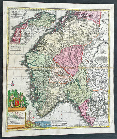
1730 Matthaus Seutter Large Antique Map of Norway
- Title : Regnum Norwegiae...Matthaei Seutteri
- Ref #: 17020
- Size: 24 1/2in x 21in (630mm x 530mm)
- Date : 1730
- Condition: (A+) Fine Condition
Description:
This large original beautifully hand coloured antique map of Norway was published by Georg Mattraus Seutter in 1730.
General Definitions:
Paper thickness and quality: - Heavy and stable
Paper color : - off white
Age of map color: - Original
Colors used: - Yellow, brown, pink, red, blue
General color appearance: - Authentic
Paper size: - 24 1/2in x 21in (630mm x 530mm)
Plate size: - 23 1/2in x 19 1/2in (590mm x 500mm)
Margins: - Min 1/2in (12mm)
Imperfections:
Margins: - None
Plate area: - Light toning along centerfold
Verso: - None
Background:
Before the fifteenth century the peoples of Southern Europe had little geographical knowledge of the Scandinavian world except from sketchy detail shown in the Catalan Atlas (1375) and on a number of \'portolani\' embracing Denmark and the southern tip of Norway. It was not until 1427 that a manuscript map prepared about that time by Claudius Clavus (b. 1388), a Dane who had spent some time in Rome, made available to scholars a tolerable outline of the northern countries and Greenland. That was to remain the best map available for the rest of the century and it was used as the basis for maps of Scandinavia in early printed editions of Ptolemy. Others by Nicolaus Cusanus (1491) and Ehrhard Etzlaub (c. 1492) followed but, needless to say, these are extremely rare; even the later maps by Olaus Magnus and Marcus Jordan, where they have survived at all, are known only by very few examples. In fact, apart from the rare appearance of an early Ptolemy map, the oldest of Scandinavia which a collector is likely to find are those in Munster\'s Cosmography published in 1544 with many later editions. In the following centuries the comparatively few maps and charts compiled in Scandinavia were usually published in Amsterdam, Antwerp, Paris or Nuremberg, the more important maps often being incorporated in the major Dutch, French and German atlases. (Ref: Tooley; M&B)

1673 Blome Antique Map Islands of Great Britain - Shetlands, Man, Wight, Channel
-
Title : A Mapp of the Isles of Wight, Jarsey, Garnsey, Sarke, Man, Orcadies and Shetland by Ric Blome by his Matys. Command
- Ref #: 17013
-
Condition: (A+) Fine Condition
- Size: 15in x 12 1/2in (380mm x 320mm)
- Date : 1673
Description:
This original hand coloured, copper plate engraved antique map of the Islands of Great Britain - Shetlands, Man, Wight, Orkenys, Jersey, Guernsey & Sark (Channel Islands) - was published by Richard Blome in the 1673 edition of Britannia: or, A Geographical Description of the Kingdoms of England, Scotland, and Ireland, with the Isles and Terrotories thereto belonging.
General Definitions:
Paper thickness and quality: - Heavy and stable
Paper color : - off white
Age of map color: - Early
Colors used: - Yellow, green, blue, pink
General color appearance: - Authentic
Paper size: - 15in x 12 1/2in (380mm x 320mm)
Plate size: - 14 1/2in x 11in (370mm x 280mm)
Margins: - Min 1/8in (5mm)
Imperfections:
Margins: - Light age toning in margins
Plate area: - None
Verso: - None
Please note all items auctioned are genuine, we do not sell reproductions. A Certificate of Authenticity (COA) can be issued on request.

1856 A K Johnston Large Antique Map of North America, Railways to Missouri
- Title : North America by AK Johnston F.R.G.S
- Ref #: 17052
- Size: 25in x 21 1/4in (635mm x 540mm)
- Date : 1856
- Condition: (A+) Fine Condition
Description:
This large original steel plate engraved hand coloured antique map by W & AK Johnston, was published in the 1856 edition of Johnstons large General Atlas.
General Definitions:
Paper thickness and quality: - Heavy and stable
Paper color : - off white
Age of map color: - Original
Colors used: - Yellow, green, blue, pink
General color appearance: - Authentic
Paper size: - 25in x 21 1/4in (635mm x 540mm)
Plate size: - 23in x 19 1/2in (590mm x 500mm)
Margins: - Min 1/2in (12mm)
Imperfections:
Margins: - None
Plate area: - None
Verso: - None
Please note all items auctioned are genuine, we do not sell reproductions. A Certificate of Authenticity (COA) can be issued on request.
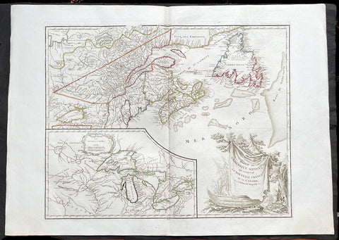
1755 (1778) De Vaugondy Large Antique Map of The Great Lakes America East Canada
- Title : Partie De L Amerique Septent. qui comprend La Nouvelle France ou le Canada...Par le Sr Robert de Vaugondy; Supplement pour Les Lacs du Canada
- Ref #: 17017
-
Condition: (A+) Fine Condition
- Size: 31 1/2in x 22 1/2in (800m x 570mm)
- Date : 1775 (1778)
Description:
This large original beautifully hand coloured, scarce 4th edition, antique map of The Great Lakes of North America, Eastern Canada & part of New England, with border changes from the 1763 Treaty of Paris, was published in 1768 by Robert Du Vaugondy in his Atlas Universal.
One of the nicest examples I have seen, of this scarce and beautiful hand coloured map, on heavy paper with original margins and heavy dark ink denoting an early pressing.
General Definitions:
Paper thickness and quality: - Heavy and stable
Paper color : - off white
Age of map color: - Original
Colors used: - Red, yellow, green, blue
General color appearance: - Authentic
Paper size: - 31 1/2in x 22 1/2in (800m x 570mm)
Plate size: - 24in x 19 1/2in (610mm x 495mm)
Margins: - Min 2in (50mm)
Imperfections:
Margins: - None
Plate area: - None
Verso: - None
Background:
The mapping of the Great Lakes region began in the early seventeenth century, when the first indications of the lakes appeared on maps made by European cartographers. By the mid-1600s, the maps of French Royal Geographer Nicolas Sanson had recognizable depictions of all five Great Lakes. His map is imprecise—Lake Superior lacks its distinctive shape and is unbounded on the west—but Lakes Ontario, Erie, Huron and Michigan can be discerned without difficulty. The lack of any reference to the Mississippi River in Sansons map reflects how little cartographers really knew about the region at the time.
Until the late eighteenth century, maps were made with information acquired in an irregular and imprecise manner. They were not based on formal surveys, but on written records supplemented with sketches by explorers, missionaries and trappers traveling the Upper Midwest. European cartographers had the task of fitting together this often contradictory information and putting the results into the framework of a geographic map. Instead of being mapped in terms of latitude and longitude, prominent places were usually located in relation to other places, which were, of course, similarly positioned. Distances could not be measured with any accuracy at this time, so these maps were liable to gross errors.
The early maps in the Making Maps, Mapping History exhibit provide a capsulized view of the growth of geographical knowledge of the Great Lakes region. As noted above, Sansons map was the first to display all five of the Great Lakes. Vincenzo Maria Coronelli, the cosmographer of the Republic of Venice, used information supplied by Jesuit missionaries in a 1688 map that was the first accurate depiction of the Great Lakes and the Mississippi River. French cartographer Guillaume De LIsle further refined the image and provided an outline that was not substantially improved until surveyors entered the region in the nineteenth century.
The first official government surveys of the Great Lakes were hydrographic surveys conducted by the British Admiralty under the direction of Capt. Henry W. Bayfield. Bayfield spent his entire career surveying the St. Lawrence River and the Great Lakes, beginning with Lake Superior in 1816. The lake-shore city of Bayfield, Wis., was named in honor of this pioneer surveyor.
One of the first acts of the new government of the United States was to establish a system for the orderly settlement of its western lands. Under the Ordinance of 1785, land surveyors went into the western territories in advance of settlement to divide the land into townships of 36 square- mile sections. Though mapping was not the governments primary aim, the surveys provided ample grist for the mapmakers mill, and the regions were, for the first time, mapped with considerable accuracy. The federal government, however, was not yet in the business of making maps for the public. That was left to enterprising individuals, such as Samuel Morrison, Elisha Dwelle and Joshua Hathaway, who produced one of the first topographical maps of the Wisconsin Territory in 1837.
The surveys of the General Land Office served as the basis for the mapping of much of the Great Lakes region from around 1800, when the surveys began, until about 1890, when the U.S. Geological Survey began to map the region again. In some cases, however, the old surveys were not entirely superseded until the mid-20th century. The distinctive feature of maps based on these surveys is the invariable presence of the township grid.
As population and commerce in the Great Lakes region grew, the federal government assumed responsibility for charting the lakes for navigation. The U.S. Lake Survey began in 1841 with an appropriation of $15,000. Before the Civil War, the work was conducted by officers of the Corps of Topographical Engineers. Its initial survey was completed in 1882, but the need for contin- uous revisions caused it to be reactivated a few years later. The Topographical Engineers merged with the U.S. Army Corps of Engineers in 1863, and the Lake Survey remained in the hands of the Corps of Engineers until 1970, when it became part of the newly formed National Ocean Survey (now known as the National Ocean Service).
The U.S. Lake Survey conducted far more rigorous surveys than those of the General Land Office, which used instruments no more sophisticated than a surveyors compass and a Gunters chain. The Lake Survey used an array of precision instruments and employed triangulation to form the geographic framework of the maps. Triangulation allowed the transfer of geographical coordinates from point to point throughout the system and, for the first time, geographical locations were determined with precision. Inland navigation prompted Congress to order a variety of government surveys. During the era of canal building, surveys like the one for the Portage Canal were common. Most of them were conducted by the Corps of Engineers, as were the surveys of the great rivers, such as the Mississippi.
The degree of accuracy accorded Great Lakes navigators was generally not matched on land for many years to come. The task of precisely mapping the United States by covering it with large-scale topographic quadrangle maps was given to the newly formed U.S. Geological Survey (USGS) in the 1880s. John Wesley Powell, the second director of the USGS, stated that the mapping of the United States could be accomplished in 25 years, but that goal was not accomplished until the 1980s. The first topographic maps of Wisconsin appeared in the 1890s, when much of the southeastern part of the state was surveyed. The surveys were quickly done, however, and most of the sheets needed at least minor revision within the next decade. Despite a rapid start, the topographic mapping of Wisconsin bogged down and ultimately was not completed until 1983. Mapping standards changed entirely with the application of aerial photography around 1930. Following World War II, all Wisconsin topographic sheets were derived from photographs.
Today, polar-orbiting satellites with thematic mappers can, in a single day, record images that reveal Great Lakes water quality and temperature, the streets and large buildings of urban areas, and the general health of forests, wetlands and farmlands, including the identity of such crops as corn, hay and alfalfa. The detailed precision of todays computerized Space Age technology no doubt would have astounded Nicolas Sanson—but the seventeenth-century mapmakers ability to create a fairly accurate map of a world he had only heard and read about is equally astounding to twenty-first-century mapmakers.
Please note all items auctioned are genuine, we do not sell reproductions. A Certificate of Authenticity (COA) can be issued on request.
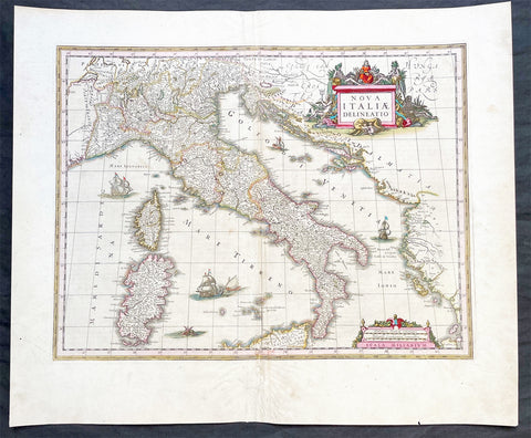
1640 Joan Blaeu Large Antique Map of Italy
- Title : Nova Italiae Delineatio
- Ref #: 17021
-
Condition: (A) Very Good Condition
- Size: 23 1/2in x 19 1/2in (595m x 495mm)
- Date : 1640
Description:
This original hand coloured copper-plate engraved antique map of Italy by Joan Blaeu was published in his 1640 edition of Atlas Novus.
General Definitions:
Paper thickness and quality: - Heavy and stable
Paper color : - off white
Age of map color: - Original
Colors used: - Red, yellow, green, blue
General color appearance: - Authentic
Paper size: - 23 1/2in x 19 1/2in (595m x 495mm)
Plate size: - 19 1/2in x 15in (595m x 380mm)
Margins: - Min 1in (25mm)
Imperfections:
Margins: - Small restoration to bottom margin centerfold, not affecting the image
Plate area: - Light creasing & uplift along centerfold
Verso: - Age toning along centerfold
Background:
Since classical times the countries bordering the enclosed waters of the Mediterranean had been well versed in the use of maps and sea charts and in Italy, more than anywhere else, the traditional knowledge was kept alive during the many hundreds of years following the collapse of the Roman Empire. By the thirteenth and fourteenth centuries the seamen of Venice, Genoa and Amalfi traded to far countries, from the Black Sea ports and the coasts of Palestine and Egypt in the East to Flanders and the southern coasts of England and Ireland in the West, their voyages guided by portulan charts and the use of the newly invented compass. For a time Italian supremacy in cartography passed to Aragon and the Catalan map makers based on Majorca, but by the year 1400 the power and wealth of the city states of Venice, Genoa, Florence and Milan surpassed any in Europe. Florence, especially, under the rule of the Medici family, became not only a great trading and financial centre but also the focal point of the rediscovery of the arts and learning of the ancient world. In this milieu a number of manuscript world maps were produced, of which one by Fra Mauro (c. 1459) is the most notable, but the event of the greatest importance in the history of cartography occurred in the year 1400 when a Florentine, Palla Strozzi, brought from Constantinople a Greek manuscript copy of Claudius Ptolemy's Geographia, which, 1,250 years after its compilation, came as a revelation to scholars in Western Europe. In the following fifty years or so manuscript copies, translated into Latin and other languages, became available in limited numbers but the invention of movable-type printing transformed the scene: the first copy without maps being printed in 1475 followed by many with copper-engraved maps, at Bologna in 1477, Rome 1478, 1490, 1507 and 1508, and Florence 1482.
About the year 1485 the first book of sea charts, compiled by Bartolommeo dalli Sonetti, was printed in Venice and in the first part of the sixteenth century a number of world maps were published, among them one compiled in 1506 by Giovanni Contarini, engraved by Francesco Rosselli, which was the first printed map to show the discoveries in the New World. In the following years there were many attractive and unusual maps of Islands (Isolano) by Bordone, Camocio and Porcacchi, but more important was the work of Giacomo (Jacopo) Gastaldi, a native of Piedmont who started life as an engineer in the service of the Venetian Republic before turning to cartography as a profession. His maps, produced in great variety and quantity, were beautifully drawn copperplate engravings and his style and techniques were widely copied by his contemporaries. From about 1550 to 1580 many of Gastaldi's maps appeared in the collections of maps known as Lafreri 'atlases', a term applied to groups of maps by different cartographers brought together in one binding. As the contents of such collections varied considerably they were no doubt assembled at the special request of wealthy patrons and are now very rare indeed.
About this time, for a variety of historical and commercial reasons, Italy's position as the leading trading and financial nation rapidly declined and with it her superiority in cartography was lost to the vigorous new states in the Low Countries. That is not to say, of course, that Italian skills as map makers were lost entirely for it was not until 1620 that the first printed maps of Italy by an Italian, Giovanni Magini, appeared, and much later in the century there were fine maps by Giacomo de Rossi and Vincenzo Coronelli, the latter leading a revival of interest in cartography at the end of the century. Coronelli was also famous for the construction of magnificent large-size globes and for the foundation in Venice in 1680 of the first geographical society.
In the eighteenth century the best-known names are Antonio Zatta, Rizzi-Zannoni and Giovanni Cassini.
We ought to mention the work of Baptista Boazio who drew a series of maps in A Summarie and True Discourse of Sir Francis Drake's West Indian Voyage, published in 1588-89, and who is especially noted for a very fine map of Ireland printed in 1599 which was incorporated in the later editions of the Ortelius atlases. It is perhaps appropriate also to refer to two English map makers who spent many years in exile in Italy: the first, George Lily, famous for the splendid map of the British Isles issued in Rome in 1546, and the second, Robert Dudley, who exactly one hundred years later was responsible for the finest sea atlas of the day, Dell' Arcano del Mare, published in Florence. Both of these are described in greater detail elsewhere in this handbook. (Ref: Tooley, Koeman)
Please note all items auctioned are genuine, we do not sell reproductions. A Certificate of Authenticity (COA) can be issued on request.
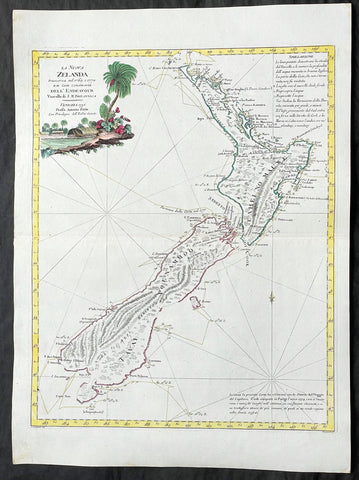
1778 Antonio Zatta Antique Map of New Zealand af. Captain James Cook - Magnificent
Antique Map
- Title : La Nuova Zelanda trascorsa nel 1769 e 1770 d'al Cook Comandante dell' Endeavour Vascello di S. M. Britannica . . . 1778
- Ref #: 17023
-
Condition: (A+) Fine Condition
- Size: 21 1/4in x 15 1/2in (540mm x 400mm)
- Date : 1778
Description:
This impressive original hand coloured copper-plate engraved very early antique map of New Zealand, after Captain James Cook, was engraved in 1778 (the first edition with a second dated 1791) was published by Antonio Zatta in his 1779 edition of Atlante Novissimo. (This is one of the best examples of this early New Zealand map I have see to date)
This is a beautifully engraved map after Captain James Cooks surveys of 1769. Cook published the first compete map of NZ in 1774, with this more decorative map being published by Zatta some 4 years later. The map contains all of Cooks coastal survey detail with some details of the interior of the islands. Also included are the tracks of Cooks ship HMS Endeavour as he surveyed the coast as well as his approach and exit from New Zealand. Beautiful original hand colour, with a heavy impression denoting an early pressing.
The maps of Venetian publisher Antonio Zatta are noteworthy for their fine craftsmanship and high aesthetics. He was probably the most important Italian map publisher of the late eighteenth century and is responsible for a large number of atlases and single maps of considerable aesthetic and scientific merit.
General Definitions:
Paper thickness and quality: - Heavy and stable
Paper color : - off white
Age of map color: - Original
Colors used: - Yellow, green, blue, pink
General color appearance: - Authentic
Paper size: - 21 1/4in x 15 1/2in (540mm x 400mm)
Plate size: - 18in x 14in (455mm x 355mm)
Margins: - Min 1/2in (12mm)
Imperfections:
Margins: - None
Plate area: - None
Verso: - None
Background:
New Zealand (or Aotearoa, as the Maori call it) had been first encountered by Europeans in the early 1640s, when Dutch explorer Abel Tasman named the land "Nieuw Zeeland" after the Dutch province. Importantly, Tasman only sailed up the west coast of the North Island and had little notion as to the nature of the islands or their broader geographical context. A small number of Tasman's place names were preserved by Cook (and remain in place to this day), including 'Cape Maria van Diemen' (the northernmost point of the North Island) and the 'Three Kings' islets, where Cook and his men celebrated the Christmas of 1769-the first Europeans to visit the islands for nearly 130 years.
Captain James Cook (1728-1779) is considered to be the greatest explorer of the eighteenth century and was the finest maritime cartographer of the Age of Enlightenment. Having first worked on coal colliers and then distinguished himself as a surveyor in Eastern Canada, in 1768 he became the British Admiralty's choice to lead an unprecedented voyage of discovery. The central impetus for the expedition was to observe the Transit of Venus from Tahiti and then to proceed to explore Terra Australis Incognita, the supposedly rich southern continent. Whereas the first part of the voyage was to be conducted under the auspices of international scientific cooperation, the second part was entirely clandestine and was only communicated to Cook via "Secret Instructions" to be opened once at sea.
Cook's party left Plymouth in August 1768 aboard the converted coal collier HMS Endeavor and proceeded to Tahiti by way of Cape Horn. They arrived in time to observe the Transit of Venus, which occurred June 3, 1769. Cook then proceeded towards New Zealand, to the coordinates recorded by Tasman. As New Zealand was quite conceivably part of Terra Australis, it was Cook's intention to carefully explore and map the region.
On October 6, 1769, the Endeavor sighted the North Island (Te Ika a Maui) at Turanga Nui, which Cook renamed Poverty Bay. He and his crew had arrived on the opposite shore to where Tasman had met the island. Cook proceeded to the South Island (Te Wai Pounamu), carefully mapping both landmasses with a running survey. He used soundings, visual observations, and triangulation regulated by astronomical observations to create his manuscript charts.
Despite being constantly buffeted by wind and rain, and after having some hostile relations with the Maori that resulted in Maori deaths, Cook and his crew managed to circumnavigate both the North and South Islands, proving that they were separate islands divided by the Cook Strait. They also proved the islands were not connected to any southern continent. On March 31, 1770, Cook wrote in his journal that the Endeavour's voyage:
…must be allowed to have set a side the most, if not all, the arguments and proofs that have been advanced by different Authors to prove that there must be a Southern Continent; I mean to the northward of 40 degrees South, for what may lay to the Southward of that Latitude I know not (Cook, Journals I, 290).
The Endeavor left New Zealand at Cape Farewell, sailing west towards Australia, where Cook's crew would become the first Europeans to explore that region. In total, they had surveyed over 2,400 miles of New Zealand coastline in six months.
Upon the Endeavour's return to England in July 1771, Cook became a national hero. He would go on to lead two further voyages that would succeed in illuminating most of the Pacific Ocean to European eyes. On the second expedition, Cook would put to rest the myth of a southern continent. On the third, he kick started the fur trade in the Pacific Northwest of North America while searching for the Northwest Passage. He was killed by Hawaiians at Kealakekua Bay in 1779.
Cook returned to England with over 300 manuscript charts and coastal views. The original manuscript chart of New Zealand is now held by the British Library (Add MS 7085, f. 16-7). The chart was drawn, at least in part, by Isaac Smith (1752-1831), a draftsman of considerable skill who worked with Cook in Newfoundland, sailed on the Endeavour and Cook's second voyage, and was related to Cook's wife. Of the New Zealand chart, Cook wrote:
The Chart which I have drawn will best point out the figure and extent of these Islands…beginning at Cape Palliser and proceed round Aehei no mouwe (North Island) by the East Cape &ca. The Coast between these two Capes I believe to be laid down pretty accurate both in its figure and the Course and distance from point to point. The oppertunities I had and the methods I made use on to obtain these requesites were such as could hardly admit of an error… some few places however must be excepted and these are very doubtfull …(Cook, Journals I, 275-6)
The overall delineation is impressively accurate, correctly capturing many of the bays and promontories, and making insightful observations of the interior. Many of the names given by Cook survive to this day, including the Alps, (the great mountain chain of the South Island), Mount Egmont (the volcano on the North Island, also known as Mount Taranaki), the Bay of Islands, the Bay of Plenty, Hawke's Bay, and most intriguingly, Cape Kidnappers (a point on the North Island where Maori warriors attempted to abduct a member of the Endeavor's crew).
There are a few errors, conspicuous only because of the otherwise superb accuracy of the chart. Notably, Cook's "Banke's Island" is in fact a peninsula, part of the South Island. Further south, what looks like a possible peninsula is actually Stewart Island, with the "Isle Solander" to the west. Also, some portions of coast line remain un-surveyed due to adverse conditions or distraction. For example, the portion of coastline near Bankes Island is but a dotted line because Lieutenant Gore had thought he sighted land to the southeast. Upon sailing toward it, the promontory proved to be clouds. Despite such mistakes, the chart is remarkably thorough.
The present chart was printed as part of the official account of Cook's first voyage, which was edited by the literary critic John Hawkesworth and underwritten by the British Admiralty. An Account of the Voyages undertaken by the order of His Present Majesty for making Discoveries in the Southern Hemisphere… (London: W. Strahan and T. Cadell, 1773) recounted the voyages not only of Cook, but of Byron, Wallis, and Carteret who had also ventured to the Pacific for the Royal Navy earlier in the 1760s. It was engraved by John Abraham Bayly (fl. 1755-1794), a London-based engraver who specialized in cartographic work.
In 1816, the British Hydrographic Office began to reprint the map for its vessels. The chart was continuously consulted into the twentieth century. Due to this longevity, its extraordinary origins, and its important place in the founding of New Zealand as a British colony, Cook's chart is considered to be the most important single map in the history of New Zealand. Due to the complexity of the assignment and the great accuracy of the survey, it is also considered to be one of Cook's very finest maps, and one of the truly great achievements of Enlightenment cartography.
Zatta, Antonio fl. 1757 - 1797
Antonio Zatta was a prominent Italian editor, cartographer, and publisher. Little is known about his life beyond his many surviving published works. It is possible that he was born as early as 1722 and lived as late as 1804. He lived in Venice and his work flourished between 1757 and 1797. He is best known for his atlas, Atlante Novissimo (1779-1785), and for his prolific output of prints and books that were both precisely made and aesthetically pleasing. Zatta clearly had a large network from which to draw information; this is how he was able to publish the first glimpse of the islands visited by Captain Cook in the Atlante Novissimo.
Zattas maps are noteworthy for their fine craftsmanship and high aesthetics. His re-engraving and publication of John Mitchells famous map of North America A Map of the British and French Dominions in North America in 1778, is considered one of the best re-issues of this seminal, landmark map .
......He was probably the most important Italian map publisher of the late eighteenth century and is responsible for a large number of atlases and single maps of considerable aesthetic and scientific merit.... (Portinaro & Knirsch, The Cartography of North America, 1500-1800, p. 319).
Zatta was among the leaders in the eighteenth-century revival of fine printing in Italy and his choice of the text of Raynal to support his re-issue of Mitchells Map, is not surprising. Anne Palms Chalmers describes Zatta as a sardonic writer with the focus of a certain amount of political controversy (Venetian Book Design in the Eighteenth Century, The Metropolitan Museum of Art Bulletin, New Series, Vol. 29, No. 5, January 1971, pp. 226-235). Chalmers describes Zattas printing and design as harmonious in composition with ornament unified by style, quality of line, and tone of printing.
Please note all items auctioned are genuine, we do not sell reproductions. A Certificate of Authenticity (COA) can be issued on request.
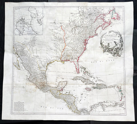
1746 J B D Anville Large Rare Antique Map of North America Pre French Indian War
-
Title : Amerique Septentrionale Publiee sous les Auspices de Monseigneur le Duc d Orleans.. Par Le Snr. D Anville MDCCXLVI
- Ref #: 17010
-
Condition: (A+) Fine Condition
- Size: 42 1/2in x 37in (1.08m x 940mm)
- Date : 1746
Description:
This large important original copper plate engraved antique map of North America, in 12 sheets joined, was engraved in 1746 - dated in the cartouche - and was published by Jean-Baptiste Bourguinon D Anville in his Elephant Folio Atlas Generale.
This map was instrumental in instructing the European Colonial powers of the time, England France & Spain the importance of dominating the New World, that ultimately led to the French and Indian War of 1754–63. This conflict determined the political direction of North America leading to the American War of Independence in 1775 and ultimately the formation of The United States of America.
To illustrate the importance of cartography in the mid eighteenth century, especially that of North America, a J B D Anville map is essential. D Anville dominated 18th century European cartography with many of his cartographical achievements, especially in North America, copied by many of his contemporaries such as Kitchen, Sayer, Homann, Seutter, Mitchell and others .
He was one of the first to leave blank spaces in his maps, where knowledge was scant or insufficient. His representation of the great lakes is superior to that of his contemporary John Mitchell, responsible for publishing one of the most famous mid 18th century maps of North America, A Map of the British and French Dominions in North America on 8 sheets in 1755 and remained the standard map of North America up until the end of the 18th century. (Ref: Tooley, Printed maps of America, 104; The Mapping of America 316)
General Definitions:
Paper thickness and quality: - Heavy and stable
Paper color : - off white
Age of map color: - Original
Colors used: - Red, yellow, green, blue
General color appearance: - Authentic
Paper size: - 42 1/2in x 37in (1.08m x 940mm)
Plate size: - 34 1/2in x 33 1/2in (875m x 850mm)
Margins: - Min 1in (25mm)
Imperfections:
Margins: - Small wormholes in left margin repaired, not affecting the image
Plate area: - Light age toning
Verso: - Age toning
Background:
The French and Indian War (1754–63) comprised the North American theatre of the worldwide Seven Years War of 1756–63. It pitted the colonies of British America against those of New France. Both sides were supported by military units from their parent countries, as well as by American Indian allies. At the start of the war, the French North American colonies had a population of roughly 60,000 settlers, compared with 2 million in the British North American colonies. The outnumbered French particularly depended on the Indians. The European nations declared war on one another in 1756 following months of localized conflict, escalating the war from a regional affair into an intercontinental conflict.
The name French and Indian War is used mainly in the United States. It refers to the two enemies of the British colonists, the royal French forces and their various American Indian allies. The British colonists were supported at various times by the Iroquois, Catawba, and Cherokee, and the French colonists were supported by Wabanaki Confederacy members Abenaki and Mikmaq, and Algonquin, Lenape, Ojibwa, Ottawa, Shawnee, and Wyandot.
British and other European historians use the term the Seven Years War, as do English-speaking Canadians. French Canadians call it La guerre de la Conquête (the War of the Conquest) or (rarely) the Fourth Intercolonial War.
Fighting took place primarily along the frontiers between New France and the British colonies, from Virginia in the south to Newfoundland in the north. It began with a dispute over control of the confluence of the Allegheny River and Monongahela River called the Forks of the Ohio, and the site of the French Fort Duquesne in Pittsburgh, Pennsylvania. The dispute erupted into violence in the Battle of Jumonville Glen in May 1754, during which Virginia militiamen under the command of 22-year-old George Washington ambushed a French patrol.
In 1755, six colonial governors in North America met with General Edward Braddock, the newly arrived British Army commander, and planned a four-way attack on the French. None succeeded, and the main effort by Braddock proved a disaster; he lost the Battle of the Monongahela on July 9, 1755 and died a few days later. British operations failed in the frontier areas of Pennsylvania and New York during 1755–57 due to a combination of poor management, internal divisions, effective Canadian scouts, French regular forces, and Indian warrior allies. In 1755, the British captured Fort Beauséjour on the border separating Nova Scotia from Acadia, and they ordered the expulsion of the Acadians (1755–64) soon afterwards. Orders for the deportation were given by William Shirley, Commander-in-Chief, North America, without direction from Great Britain. The Acadians were expelled, both those captured in arms and those who had sworn the loyalty oath to His Britannic Majesty. Indians likewise were driven off the land to make way for settlers from New England.
The British colonial government fell in the region of modern Nova Scotia after several disastrous campaigns in 1757, including a failed expedition against Louisbourg and the Siege of Fort William Henry; this last was followed by Indians torturing and massacring their British victims. William Pitt came to power and significantly increased British military resources in the colonies at a time when France was unwilling to risk large convoys to aid the limited forces that they had in New France, preferring to concentrate their forces against Prussia and its allies in the European theater of the war. Between 1758 and 1760, the British military launched a campaign to capture the Colony of Canada (part of New France). They succeeded in capturing territory in surrounding colonies and ultimately the city of Quebec (1759). The British later lost the Battle of Sainte-Foy west of Quebec (1760), but the French ceded Canada in accordance with the Treaty of Paris (1763).
The outcome was one of the most significant developments in a century of Anglo-French conflict. France ceded to Great Britain its territory east of the Mississippi. It ceded French Louisiana west of the Mississippi River (including New Orleans) to its ally Spain in compensation for Spains loss to Britain of Florida. (Spain had ceded Florida to Britain in exchange for the return of Havana, Cuba.) Frances colonial presence north of the Caribbean was reduced to the islands of Saint Pierre and Miquelon, confirming Great Britains position as the dominant colonial power in eastern North America.
Please note all items auctioned are genuine, we do not sell reproductions. A Certificate of Authenticity (COA) can be issued on request.
1692 Vincenzo Coronelli Large Original Antique Globe Gore Map of South America
-
Title : South America
- Ref #: 17007
-
Condition: (A+) Fine Condition
- Size: 19 1/2in x 12 1/4in (495mm x 310mm)
- Date : 1692
Description:
This large original antique copper plate engraved Globe Gore, a map of South America - from Vincenzo Coronellis original 42in Globe - was published by Vincenzo Maria Coronelli in the 1696 Venice edition of Isolario dell Atlante Veneto.
To my mind Coronellis maps are some of the most beautifully engraved maps of the 17th century and the epitome of these are his Globe Gores.
In 1696 Coronelli published all his globe gores - from the 2in to the 42 in Globes - in an atlas, Libero dei Globi, part of the great series of atlases, Isolario dell Atlante Veneto that was published by Coronelli to ensure his work was available to a wider audience, as very few could afford travel to Venice, Rome or Paris to view his completed globes.
General Definitions:
Paper thickness and quality: - Heavy and stable
Paper color : - off white
Age of map color: -
Colors used: -
General color appearance: -
Paper size: - 19 1/2in x 12 1/4in (495mm x 310mm)
Plate size: - 18in x 11in (455mm x 280mm)
Margins: - Min 1/2in (12mm)
Imperfections:
Margins: - None
Plate area: - None
Verso: - None
Background:
The original globe gores for the 42in Terrestrial & Celestial Globe were printed on 12 full length sheets - with two polar calottes - in 1688.
To help fit into Coronellis future publications of Atlante Veneto, Libro dei Globi and Isolario dell Atlante Veneto the gore sheets were re-issued as the same size but cut into smaller sections. This effectively allowed the gores to be published in their original size but instead of one sheet per gore there were 2, 4 or 6 sheets making up the one gore.
The first edition of Coronellis 3 ½-foot celestial globe was engraved by Nolin in Paris after drawings provided by the Italian geographer and was printed in 1688. At the same time, its terrestrial counterpart was engraved and printed in Venice under Coronellis direction. These globes were produced in part as replicas of the gigantic and unique 15 foot-diameter pair of globes that Coronelli constructed and presented to Louis XIV, the King of France, in 1683, and which secured his fame as Europes premier globe maker. In 1693, soon after Coronelli engraved and printed the first Venetian edition of the 3 ½-foot celestial globe, Nolin engraved at Paris an entirely new edition on new plates. This globe was based on Coronellis work, but with the main legends in Latin, not Italian, as befitted a French market. The 3 ½ foot celestial globe was one of the crowning glories of Coronellis output and was also the grandest celestial globe of the 17th century.
(Ref: Shirley; Armao, Ermanno. Vincenzo Coronelli Cenni sulluomo e la sua Vita Catalogo... Bibliopolis, Florence pp.130-134)
Please note all items auctioned are genuine, we do not sell reproductions. A Certificate of Authenticity (COA) can be issued on request.
1825 Philippe Vandermaelen Large Antique Map of Vanuatu, South Pacific, Hebrides
-
Title : Archipel Des Nlles Hebrides
- Ref #: 17002
-
Condition: (A+) Fine Condition
- Size: 28 1/2in x 21in (725mm x 550mm)
- Date : 1825
Description:
This very large original hand coloured antique lithograph map of the New Hebrides Islands, now know as Vanuatu, in the South Pacific was published by Philippe Vandermaelen in his revolutionary 1825 Atlas universel de geographie physique, politique, statistique et mineralogique.
Until the publication of this atlas, large detailed maps of this region of Australia & the Pacific were uncommon.
General Definitions:
Paper thickness and quality: - Heavy and stable
Paper color : - off white
Age of map color: - Early
Colors used: - Red, yellow, green, blue
General color appearance: - Authentic
Paper size: - 28 1/2in x 21in (725mm x 550mm)
Plate size: - 28 1/2in x 21in (725mm x 550mm)
Margins: - Min 1/2in (12mm)
Imperfections:
Margins: - None
Plate area: - None
Verso: - None
Background:
New Hebrides, officially the New Hebrides Condominium (French: Condominium des Nouvelles-Hébrides, lit. Condominium of the New Hebrides) and named for the Hebrides Scottish archipelago, was the colonial name for the island group in the South Pacific Ocean that is now Vanuatu. Native people had inhabited the islands for three thousand years before the first Europeans arrived in 1606 from a Spanish expedition led by Portuguese navigator Pedro Fernandes de Queirós. The islands were colonised by both the British and French in the 18th century, shortly after Captain James Cook visited.
The two countries eventually signed an agreement making the islands an Anglo-French condominium that divided New Hebrides into two separate communities: one Anglophone and one Francophone. That divide continued even after independence, with schools teaching in either one language or the other, and with different political parties. The condominium lasted from 1906 until 1980, when New Hebrides gained its independence as the Republic of Vanuatu.
Vandermaelen, Philippe M G 1795-1869
Vandermaelen was the son of the wealthy soap manufacturer; he abandoned the soap trade and devoted his life to cartography. Entirely self-taught in geometry, astronomy and the geosciences, he began drafting the first sheets of an Atlas universel in 1824. This atlas was published between 1825 and 1827; it was sold in forty instalments of ten maps each and became a great success. The revenue enabled him to set up his own Etablissement géographique de Bruxelles in 1830, which not only produced maps, atlases and globes in large quantities but also housed a natural science museum, botanical gardens, a library, and an impressive collection of maps.
Shortly after the closing of Vandermaelens Institute, the Royal Library of Belgium (KBR) in 1880 acquired a large part of its cartographic collection and production.
Vandermaelens atlas was remarkable: 387 maps on a uniform scale of ca. 1:1.6 million. There was one edition of this very rare atlas, published in 1825-27; the subscription list shows that only 810 copies were sold. The six volumes, of which Africa was in Volume III (60 maps), were issued in instalments during the period 1825-1827.
This folio-size atlas is remarkable for several reasons. It is the first atlas produced by the then new printing process of lithography. It is also the first atlas to show the whole world in 380 maps using a large uniform scale—about 10km to the cm. on a modified conical projection described by Sanson-Flamsteed. Based on a prime meridian through Paris, each map has a drawn-out graticule giving it a trapezoidal form, the underlying intention being construction of a globe with a diameter of 7.755m Eugene Gilbert de Cauwer , his biographer, suggested that Vandernaelen was a worthy follower of Mercator and Ortelius.
Vandermaelen enlisted the assistance of lithographer-printer Hippolyte Ode in this ambitious project which introduced lithography into Belgium and created an upsurge in Belgian publishing. A number of maps were lithographed by Philippe Vandermaelen himself. For many of the areas depicted, these maps are the largest scale maps made at the time, and the most detailed. The lithographs are very well drawn and printed and should be appreciated in the context of lithography, which was a developing art at the time. The maps are handsome and detailed, although some of the place names are somewhat curious and the cartography sometimes imaginary. Nevertheless, the Vandermaelen maps are of great significance in the history of cartography and lithography. Visually, they are arresting and unusual. Vandermaelens maps best are appreciated in the context of its neighbouring maps - they were all meant to be joined .
Please note all items auctioned are genuine, we do not sell reproductions. A Certificate of Authenticity (COA) can be issued on request.

1825 Philippe Vandermaelen Large Antique Map Admiralty or Manus Islands Pacific
-
Title : Iles De L Amiraute
- Ref #: 17005
-
Condition: (A+) Fine Condition
- Size: 28 1/2in x 21in (725mm x 550mm)
- Date : 1825
Description:
This very large original hand coloured antique lithograph map of the Admiralty or Manus Islands, north of New Guinea, in the South Pacific was published by Philippe Vandermaelen in his revolutionary 1825 Atlas universel de geographie physique, politique, statistique et mineralogique.
Until the publication of this atlas, large detailed maps of this region of Australia & the Pacific were uncommon.
General Definitions:
Paper thickness and quality: - Heavy and stable
Paper color : - off white
Age of map color: - Early
Colors used: - Red, yellow, green, blue
General color appearance: - Authentic
Paper size: - 28 1/2in x 21in (725mm x 550mm)
Plate size: - 28 1/2in x 21in (725mm x 550mm)
Margins: - Min 1/2in (12mm)
Imperfections:
Margins: - None
Plate area: - None
Verso: - None
Background:
The first European to visit the islands was the Spanish navigator Álvaro de Saavedra when trying to return from Tidore to New Spain in the summer of 1528. Saavedra charted Manus as Urays la Grande. Its visit was also reported in 1616 by the Dutch navigator Willem Schouten. The name Admiralty Islands was devised by Captain Philip Carteret of the British Royal Navy in 1767.
Between 1884 and 1914 the area was administered as a German colony. In November 1914, the islands were occupied by troops of the Australian Naval and Military Expeditionary Force landed from the SS Siar. A few shots fired from a machine gun on Siar over the heads of the tiny German garrison at Lorengau were the last shots fired in the battle. After the war, the islands were governed by the Commonwealth of Australia under a League of Nations mandate.
Japanese troops landed on Manus Island on 7 April 1942. In 1944, Japanese forces occupying the islands were attacked and defeated by Allied forces in Operation Brewer. Subsequently, a large American airbase was built at Lombrum near Lorengau.
Vandermaelen, Philippe M G 1795-1869
Vandermaelen was the son of the wealthy soap manufacturer; he abandoned the soap trade and devoted his life to cartography. Entirely self-taught in geometry, astronomy and the geosciences, he began drafting the first sheets of an Atlas universel in 1824. This atlas was published between 1825 and 1827; it was sold in forty instalments of ten maps each and became a great success. The revenue enabled him to set up his own Etablissement géographique de Bruxelles in 1830, which not only produced maps, atlases and globes in large quantities but also housed a natural science museum, botanical gardens, a library, and an impressive collection of maps.
Shortly after the closing of Vandermaelens Institute, the Royal Library of Belgium (KBR) in 1880 acquired a large part of its cartographic collection and production.
Vandermaelens atlas was remarkable: 387 maps on a uniform scale of ca. 1:1.6 million. There was one edition of this very rare atlas, published in 1825-27; the subscription list shows that only 810 copies were sold. The six volumes, of which Africa was in Volume III (60 maps), were issued in instalments during the period 1825-1827.
This folio-size atlas is remarkable for several reasons. It is the first atlas produced by the then new printing process of lithography. It is also the first atlas to show the whole world in 380 maps using a large uniform scale—about 10km to the cm. on a modified conical projection described by Sanson-Flamsteed. Based on a prime meridian through Paris, each map has a drawn-out graticule giving it a trapezoidal form, the underlying intention being construction of a globe with a diameter of 7.755m Eugene Gilbert de Cauwer , his biographer, suggested that Vandernaelen was a worthy follower of Mercator and Ortelius.
Vandermaelen enlisted the assistance of lithographer-printer Hippolyte Ode in this ambitious project which introduced lithography into Belgium and created an upsurge in Belgian publishing. A number of maps were lithographed by Philippe Vandermaelen himself. For many of the areas depicted, these maps are the largest scale maps made at the time, and the most detailed. The lithographs are very well drawn and printed and should be appreciated in the context of lithography, which was a developing art at the time. The maps are handsome and detailed, although some of the place names are somewhat curious and the cartography sometimes imaginary. Nevertheless, the Vandermaelen maps are of great significance in the history of cartography and lithography. Visually, they are arresting and unusual. Vandermaelens maps best are appreciated in the context of its neighbouring maps - they were all meant to be joined .
Please note all items auctioned are genuine, we do not sell reproductions. A Certificate of Authenticity (COA) can be issued on request.

1825 Philippe Vandermaelen Large Antique Map of Austral Islands French Polynesia
-
Title : Partie De L Archipel Des Iles Basses
- Ref #: 17006
-
Condition: (A+) Fine Condition
- Size: 28 1/2in x 21in (725mm x 550mm)
- Date : 1825
Description:
This very large original hand coloured antique lithograph map of the Austral Islands in the French Polynesia group of islands in the in the South Pacific was published by Philippe Vandermaelen in his revolutionary 1825 Atlas universel de geographie physique, politique, statistique et mineralogique.
Until the publication of this atlas, large detailed maps of this region of Australia & the Pacific were uncommon.
General Definitions:
Paper thickness and quality: - Heavy and stable
Paper color : - off white
Age of map color: - Early
Colors used: - Red, yellow, green, blue
General color appearance: - Authentic
Paper size: - 28 1/2in x 21in (725mm x 550mm)
Plate size: - 28 1/2in x 21in (725mm x 550mm)
Margins: - Min 1/2in (12mm)
Imperfections:
Margins: - None
Plate area: - None
Verso: - None
Background:
New Hebrides, officially the New Hebrides Condominium (French: Condominium des Nouvelles-Hébrides, lit. Condominium of the New Hebrides) and named for the Hebrides Scottish archipelago, was the colonial name for the island group in the South Pacific Ocean that is now Vanuatu. Native people had inhabited the islands for three thousand years before the first Europeans arrived in 1606 from a Spanish expedition led by Portuguese navigator Pedro Fernandes de Queirós. The islands were colonised by both the British and French in the 18th century, shortly after Captain James Cook visited.
The two countries eventually signed an agreement making the islands an Anglo-French condominium that divided New Hebrides into two separate communities: one Anglophone and one Francophone. That divide continued even after independence, with schools teaching in either one language or the other, and with different political parties. The condominium lasted from 1906 until 1980, when New Hebrides gained its independence as the Republic of Vanuatu.
Vandermaelen, Philippe M G 1795-1869
Vandermaelen was the son of the wealthy soap manufacturer; he abandoned the soap trade and devoted his life to cartography. Entirely self-taught in geometry, astronomy and the geosciences, he began drafting the first sheets of an Atlas universel in 1824. This atlas was published between 1825 and 1827; it was sold in forty instalments of ten maps each and became a great success. The revenue enabled him to set up his own Etablissement géographique de Bruxelles in 1830, which not only produced maps, atlases and globes in large quantities but also housed a natural science museum, botanical gardens, a library, and an impressive collection of maps.
Shortly after the closing of Vandermaelens Institute, the Royal Library of Belgium (KBR) in 1880 acquired a large part of its cartographic collection and production.
Vandermaelens atlas was remarkable: 387 maps on a uniform scale of ca. 1:1.6 million. There was one edition of this very rare atlas, published in 1825-27; the subscription list shows that only 810 copies were sold. The six volumes, of which Africa was in Volume III (60 maps), were issued in instalments during the period 1825-1827.
This folio-size atlas is remarkable for several reasons. It is the first atlas produced by the then new printing process of lithography. It is also the first atlas to show the whole world in 380 maps using a large uniform scale—about 10km to the cm. on a modified conical projection described by Sanson-Flamsteed. Based on a prime meridian through Paris, each map has a drawn-out graticule giving it a trapezoidal form, the underlying intention being construction of a globe with a diameter of 7.755m Eugene Gilbert de Cauwer , his biographer, suggested that Vandernaelen was a worthy follower of Mercator and Ortelius.
Vandermaelen enlisted the assistance of lithographer-printer Hippolyte Ode in this ambitious project which introduced lithography into Belgium and created an upsurge in Belgian publishing. A number of maps were lithographed by Philippe Vandermaelen himself. For many of the areas depicted, these maps are the largest scale maps made at the time, and the most detailed. The lithographs are very well drawn and printed and should be appreciated in the context of lithography, which was a developing art at the time. The maps are handsome and detailed, although some of the place names are somewhat curious and the cartography sometimes imaginary. Nevertheless, the Vandermaelen maps are of great significance in the history of cartography and lithography. Visually, they are arresting and unusual. Vandermaelens maps best are appreciated in the context of its neighbouring maps - they were all meant to be joined .
Please note all items auctioned are genuine, we do not sell reproductions. A Certificate of Authenticity (COA) can be issued on request.
1695 Robert Morden Antique Map of the Islands of Great Britain & Ireland
-
Title : The Smaller Islands in the British Ocean by Rob Morden sold by Mel Swale Awnsham and John Churchill
- Ref #: 17012
-
Condition: (A) Very Good Condition
- Size: 17 1/2in x 15 1/2in (445mm x 395mm)
- Date : 1695
Description:
This fine original copper-plate engraved hand coloured antique map of the many Islands off the coast of Great Britain & Ireland by Robert Morden was published in the 1695 edition of Camdens Britannia.
General Definitions:
Paper thickness and quality: - Heavy and stable
Paper color : - off white
Age of map color: - Early
Colors used: - Red, yellow, green, blue
General color appearance: - Authentic
Paper size: - 17 1/2in x 15 1/2in (445mm x 395mm)
Plate size: - 17in x 141/2in (430mm x 370mm)
Margins: - Min 1/2in (12mm)
Imperfections:
Margins: - None
Plate area: - None
Verso: - Mounted to original board
Background:
These maps are the first county maps to show roads (based on Ogilby’s road maps) and show three scales representing great, middle and small miles as different scales were used in different parts of the country. Morden was employed to replace the outdated maps by Saxton, engraved by Kip and Hole. He based his maps on manuscript sources plus the surveys of Ogilby and Morgan, Seller, Palmer and the coastal charts of Captain Grenville Collins. One innovation was the showing of longitudes measured from the meridian of St. Paul's Cathedral given in the form of time in minutes at the top of the map in Roman numerals and at the bottom in degrees. This was done to clarify local times that were taken from the sun as there was no national standard time. Gibson said:' Where actual Surveys could be had, they were purchased at any rate; and for the rest, one of the best Copies extanct was sent to some of the most knowing Gentlemen in each County; with a request to supply the defects, rectified the positions, and correct the false spellings. And that nothing might be wanting to render them as complete and accurate as might be, this whole business was commited to Mr Robert Morden, a person of know abilities in these matters'..from the Preface of the Britannia.
Morden, Robert 1650 - 1703
Morden was an English bookseller, publisher, and maker of maps and globes. He was among the first successful commercial map makers.
Between about 1675 and his death in 1703, he was based under the sign of the Atlas at premises in Cornhill and New Cheapside, London. His cartographical output was large and varied. His best-known maps are those of South Wales, North Wales and the English Counties first published in a new edition of Camdens Britannia in 1695, and subsequently reissued in 1722, 1753 and 1772. These maps were based on new information from gentlemen of each county, and were newly engraved. Each had a decorated cartouche, and showed numerous place names. Morden also produced in 1701 a series of smaller county maps often known as Miniature Mordens.
In 1695 he published a map of Scotland. It is in parts (e.g. Skye and the Western Isles) essentially a copy of the 1654 map done by Robert Gordon of Straloch, published by Joan Blaeu; other parts show evidence of more accurate cartography.
His (fourth edition) of Geography Rectified: or a Description of the World from 1700 dedicated to a Thomas Goddard, is a comprehensive work from many aspects. Its more than 700 pages, including a long pedagogic preface, no less than 78 maps from Europe including the British Isles, Asia, Africa, America and a two circular maps of the world, representing planet Earth seen from exactly opposite sides - the known world as of its time. (Australia and Antarctica were not yet known in Europe by then.) It further contains explanations of many general geographical concepts such as Latitude and Longitude and more. It also contains several comparisons of commodities, customs, history, governments, coins and weights (etc) with those in London. Its index is extensive. A copy has been stored at British Museum for more than a century.
He published a new map of the Tamil homeland, Coylot Wanees Country, in 17th-century Ceylon island.
He is also known for several very rare early maps of the British colonies in North America, which are now among the earliest and most sought after maps for collectors of old American maps. He also produced a series of miniature maps of the world, which appeared in both playing card format and in a series of atlases, including his Atlas Terrestris and Geography Anatomizd, beginning in 1687.
Please note all items auctioned are genuine, we do not sell reproductions. A Certificate of Authenticity (COA) can be issued on request.
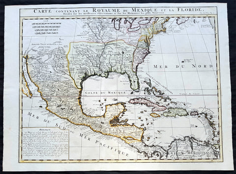
1719 Chatelain Antique Map of North America, GOM, Caribbean, United States
- Title : Carte Contenant Le Royaume Du Mexique Et La Floride
- Date : 1719
- Condition: (A+) Fine Condition
- Ref: 50621
- Size: 23 1/4in x 17 1/2in (590m x 445m)
Description:
This large beautifully hand coloured original antique foundation map of North America and the Caribbean - after Delisle landmark map of 1703 - was published by Henri Abraham Chatelain in 1719, in his famous Atlas Historique.
Background:
A very attractive example of Chatelain's issue of Guillaume De L'Isle's foundation map of present-day United States, Central America and the West Indies, originally published in 1703. Guillaume De L'Isle brought a new scientific approach to mapmaking at the end of the seventeenth century and his rigorously prepared maps of all areas became the standards for much of the following century.
Amongst his most important works were those relating to the New World, especially North America, where the recent reports of French travellers into the interior were utilised. Sources for this map - the first to show the lower reaches of the Mississippi accurately - included d'Iberville, Tonty and Le Sueur, Father Gravier, and Bienville (later to become Governor of the French colony of Louisiana). Evidence of the contemporary superiority of De L'Isle's maps lies in the numerous copies, published in Paris, Amsterdam, London and Germany, and the republishing of the original plate over many years. Geographically his maps were as correct, however, this map is also remarkable for De L'Isle's political boundaries which squeeze the English Colonies, on the east coast into a narrow strip, thus allocating the greater part of North America to France. Chatelain's map has a large panel of text describing Mexico and Florida at lower left.
General Description:
Paper thickness and quality: - Heavy and stable
Paper color: - White
Age of map color: - Early
Colors used: - Pink, green, yellow, blue
General color appearance: - Authentic
Paper size: - 23 1/4in x 17 1/2in (590m x 445m)
Plate size: - 20 3/4in x 16 1/4in (530m x 415mm)
Margins: - min. 1/2in (12mm)
Imperfections: Margins: - None
Plate area: - Folds as issued
Verso: - None
1756 Homann Antique Map Colonial United States North America French Indian War
- Title : America Septentrionalis a domino d Anville in Galiis edita nunc in Anglia coloniis in interiorem Virginiam deductis nec non fluvii Ohio cursu aucta notisq geographicis et historicis illustrata.....1756
- Ref #: 17001
- Size: 21in x 19in (535mm x 480mm)
- Date : 1756
- Condition: (A) Very Good Condition
Description:
This original hand coloured copper-plate engraved antique 1st edition map of the Colonial United States, at the beginning of the French-Indian war, was engraved in 1756 - dated in cartouche - by the Homann firm, Germany.
First edition Homann map of the English Colonies in North America prior to the start of the French and Indian War. The map stretches just west of the Mississippi River to the east and from James Bay through the Great Lakes to the Gulf of Mexico. Although most of the text is in German, there is also much in English, including numerous place named annotations associated the French and Indian War, such as the locations of Fort Duquesne and Fort Necessity, both taken by the French in 1754. Thus although the cartographer credits D Anville for the basic cartography, it is clear he is drawing from English, not French, sources. Bottom right and upper left are notes offering the history of North America.
General Definitions:
Paper thickness and quality: - Heavy and stable
Paper color : - off white
Age of map color: - Original & later
Colors used: - Yellow, green, blue, pink
General color appearance: - Authentic
Paper size: - 21in x 19in (535mm x 480mm)
Plate size: - 21in x 19in (535mm x 480mm)
Margins: - Min 1/2in (12mm)
Imperfections:
Margins: - All margins extended from border
Plate area: - Light crease adjacent to centerfold, soiling in top right border
Verso: - Light soiling.
Background:
The French and Indian War (1754–63) comprised the North American theatre of the worldwide Seven Years War of 1756–63. It pitted the colonies of British America against those of New France. Both sides were supported by military units from their parent countries, as well as by American Indian allies. At the start of the war, the French North American colonies had a population of roughly 60,000 settlers, compared with 2 million in the British North American colonies. The outnumbered French particularly depended on the Indians. The European nations declared war on one another in 1756 following months of localized conflict, escalating the war from a regional affair into an intercontinental conflict.
The name French and Indian War is used mainly in the United States. It refers to the two enemies of the British colonists, the royal French forces and their various American Indian allies. The British colonists were supported at various times by the Iroquois, Catawba, and Cherokee, and the French colonists were supported by Wabanaki Confederacy members Abenaki and Mikmaq, and Algonquin, Lenape, Ojibwa, Ottawa, Shawnee, and Wyandot.
British and other European historians use the term the Seven Years War, as do English-speaking Canadians. French Canadians call it La guerre de la Conquête (the War of the Conquest) or (rarely) the Fourth Intercolonial War.
Fighting took place primarily along the frontiers between New France and the British colonies, from Virginia in the south to Newfoundland in the north. It began with a dispute over control of the confluence of the Allegheny River and Monongahela River called the Forks of the Ohio, and the site of the French Fort Duquesne in Pittsburgh, Pennsylvania. The dispute erupted into violence in the Battle of Jumonville Glen in May 1754, during which Virginia militiamen under the command of 22-year-old George Washington ambushed a French patrol.
In 1755, six colonial governors in North America met with General Edward Braddock, the newly arrived British Army commander, and planned a four-way attack on the French. None succeeded, and the main effort by Braddock proved a disaster; he lost the Battle of the Monongahela on July 9, 1755 and died a few days later. British operations failed in the frontier areas of Pennsylvania and New York during 1755–57 due to a combination of poor management, internal divisions, effective Canadian scouts, French regular forces, and Indian warrior allies. In 1755, the British captured Fort Beauséjour on the border separating Nova Scotia from Acadia, and they ordered the expulsion of the Acadians (1755–64) soon afterwards. Orders for the deportation were given by William Shirley, Commander-in-Chief, North America, without direction from Great Britain. The Acadians were expelled, both those captured in arms and those who had sworn the loyalty oath to His Britannic Majesty. Indians likewise were driven off the land to make way for settlers from New England.
The British colonial government fell in the region of modern Nova Scotia after several disastrous campaigns in 1757, including a failed expedition against Louisbourg and the Siege of Fort William Henry; this last was followed by Indians torturing and massacring their British victims. William Pitt came to power and significantly increased British military resources in the colonies at a time when France was unwilling to risk large convoys to aid the limited forces that they had in New France, preferring to concentrate their forces against Prussia and its allies in the European theater of the war. Between 1758 and 1760, the British military launched a campaign to capture the Colony of Canada (part of New France). They succeeded in capturing territory in surrounding colonies and ultimately the city of Quebec (1759). The British later lost the Battle of Sainte-Foy west of Quebec (1760), but the French ceded Canada in accordance with the Treaty of Paris (1763).
The outcome was one of the most significant developments in a century of Anglo-French conflict. France ceded to Great Britain its territory east of the Mississippi. It ceded French Louisiana west of the Mississippi River (including New Orleans) to its ally Spain in compensation for Spains loss to Britain of Florida. (Spain had ceded Florida to Britain in exchange for the return of Havana, Cuba.) Frances colonial presence north of the Caribbean was reduced to the islands of Saint Pierre and Miquelon, confirming Great Britains position as the dominant colonial power in eastern North America.
Please note all items auctioned are genuine, we do not sell reproductions. A Certificate of Authenticity (COA) can be issued on request.

1825 Philippe Vandermaelen Large Antique Map of The Solomon Islands
- Title : Oceanique. Partie Des Iles Salomon
- Ref #: 17003
- Size: 28 1/2in x 21in (725mm x 550mm)
- Date : 1825
- Condition: (A+) Fine Condition
Description:
This very large original hand coloured antique lithograph map of the Solomon Islands in the South Pacific was published by Philippe Vandermaelen in his revolutionary 1825 Atlas universel de geographie physique, politique, statistique et mineralogique.
Until the publication of this atlas, large detailed maps of this region of Australia & the Pacific were uncommon.
General Definitions:
Paper thickness and quality: - Heavy and stable
Paper color : - off white
Age of map color: - Original
Colors used: - Yellow, green, blue, pink
General color appearance: - Authentic
Paper size: - 28 1/2in x 21in (725mm x 550mm)
Plate size: - 28 1/2in x 21in (725mm x 550mm)
Margins: - Min 1/2in (12mm)
Imperfections:
Margins: - None
Plate area: - None
Verso: - None
Background:
The first European to visit the islands was the Spanish navigator Álvaro de Mendaña de Neira, sailing from Peru in 1568. Landing on Santa Isabel on 7 February, Mendaña explored several of the other islands including Makira, Guadalcanal and Malaita. Relations with the native Solomon Islanders were initially cordial, though often soured as time went by. As a result, Mendaña returned to Peru in August 1568. He returned to the Solomons with a larger crew on a second voyage in 1595, aiming to colonise the islands. They landed on Nendö in the Santa Cruz Islands and established a small settlement at Gracioso Bay. However the settlement failed due to poor relations with the native peoples and epidemics of disease amongst the Spanish which caused numerous deaths, with Mendaña himself dying in October. The new commander Pedro Fernandes de Queirós thus decided to abandon the settlement and they sailed north to the Spanish territory of the Philippines. Queirós later returned to the area in 1606, where he sighted Tikopia and Taumako, though this voyage was primarily to Vanuatu in the search of Terra Australis.
Save for Abel Tasmans sighting of the remote Ontong Java Atoll in 1648, no European sailed to the Solomons again until 1767, when the British explorer Philip Carteret sailed by the Santa Cruz Islands, Malaita and, continuing further north, Bougainville and the Bismarck Islands. French explorers also reached the Solomons, with Louis Antoine de Bougainville naming Choiseul in 1768 and Jean-François-Marie de Surville exploring the islands in 1769. In 1788 John Shortland, captaining a supply ship for Britains new Australian colony at Botany Bay, sighted the Treasury and Shortland Islands. That same year the French explorer Jean-François de La Pérouse was wrecked on Vanikoro; a rescue expedition led by Bruni dEntrecasteaux sailed to Vanikoro but found no trace of La Pérouse. The fate of La Pérouse was not confirmed until 1826, when the English merchant Peter Dillon visited Tikopia and discovered items belonging to La Pérouse in the possession of the local people, confirmed by the subsequent voyage of Jules Dumont dUrville in 1828.
Some of the earliest regular foreign visitors to the islands were whaling vessels from Britain, the United States and Australia. They came for food, wood and water from late in the 18th century, establishing a trading relationship with the Solomon Islanders and later taking aboard islanders to serve as crewmen on their ships. Relations between the islanders and visiting seamen was not always good and sometimes there was bloodshed. A knock-on effect of the greater European contact was the spread of diseases to which local peoples had no immunity, as well a shift in the balance of power between coastal groups, who had access to European weapons and technology, and inland groups who did not. In the second half of the 1800s more traders arrived seeking turtleshells, sea cucumbers, copra and sandalwood, occasionally establishing semi-permanent trading stations. However initial attempts at more long-term settlement, such as Benjamin Boyds colony on Guadalcanal in 1851, were unsuccessful.
Vandermaelen, Philippe M G 1795-1869
Vandermaelen was the son of the wealthy soap manufacturer; he abandoned the soap trade and devoted his life to cartography. Entirely self-taught in geometry, astronomy and the geosciences, he began drafting the first sheets of an Atlas universel in 1824. This atlas was published between 1825 and 1827; it was sold in forty instalments of ten maps each and became a great success. The revenue enabled him to set up his own Etablissement géographique de Bruxelles in 1830, which not only produced maps, atlases and globes in large quantities but also housed a natural science museum, botanical gardens, a library, and an impressive collection of maps.
Shortly after the closing of Vandermaelens Institute, the Royal Library of Belgium (KBR) in 1880 acquired a large part of its cartographic collection and production.
Vandermaelens atlas was remarkable: 387 maps on a uniform scale of ca. 1:1.6 million. There was one edition of this very rare atlas, published in 1825-27; the subscription list shows that only 810 copies were sold. The six volumes, of which Africa was in Volume III (60 maps), were issued in instalments during the period 1825-1827.
This folio-size atlas is remarkable for several reasons. It is the first atlas produced by the then new printing process of lithography. It is also the first atlas to show the whole world in 380 maps using a large uniform scale—about 10km to the cm. on a modified conical projection described by Sanson-Flamsteed. Based on a prime meridian through Paris, each map has a drawn-out graticule giving it a trapezoidal form, the underlying intention being construction of a globe with a diameter of 7.755m Eugene Gilbert de Cauwer , his biographer, suggested that Vandernaelen was a worthy follower of Mercator and Ortelius.
Vandermaelen enlisted the assistance of lithographer-printer Hippolyte Ode in this ambitious project which introduced lithography into Belgium and created an upsurge in Belgian publishing. A number of maps were lithographed by Philippe Vandermaelen himself. For many of the areas depicted, these maps are the largest scale maps made at the time, and the most detailed. The lithographs are very well drawn and printed and should be appreciated in the context of lithography, which was a developing art at the time. The maps are handsome and detailed, although some of the place names are somewhat curious and the cartography sometimes imaginary. Nevertheless, the Vandermaelen maps are of great significance in the history of cartography and lithography. Visually, they are arresting and unusual. Vandermaelens maps best are appreciated in the context of its neighbouring maps - they were all meant to be joined .
Please note all items auctioned are genuine, we do not sell reproductions. A Certificate of Authenticity (COA) can be issued on request.

1862 John Gould Large Antique Print Birds of Great Britain - Pine Grosbeak
- Title : Pinicola Enucleator
- Ref #: 23486
- Size: 21 1/2in x 14in (545mm x 360mm)
- Date : 1862
- Condition: (A+) Fine Condition
Description:
This large original hand coloured antique lithograph of the male & female Pine Grosbeak or Pinicola Enucleator, found from Siberia to the United States, was published in the 1862-73 edition of John Goulds The Birds of Great Britain. Lithography by J Gould, HC Richter & Walter.
The University of Glasgow, which owns a copy of Birds of Great Britain, describes John Gould as the greatest figure in bird illustration after Audubon. Gould was not directly responsible for the illustrations himself, although he supervised their production closely. Auctioneers Sotherans describe the work as Goulds pride and joy.
Gould had already published some of the illustrations in Birds of Europe, but Birds of Great Britain represents a development of an aesthetic style in which illustrations of nests and young are added on a large scale.
Sotherans Co. reports that Gould published the book himself, producing 750 copies, which remain sought after both as complete volumes, and as individual plates, currently varying in price from £450 – £850. The University of Glasgow records that the volumes were issued in London in 25 parts, to make the complete set, between 1863 and 1873, and each set contained 367 coloured lithographs.
Gould undertook an ornithological tour of Scandinavia in 1856, in preparation for the work, taking with him the artist Henry Wolf who drew 57 of the plates from Goulds preparatory sketches. According to The University of Glasgow Goulds skill was in rapidly producing rough sketches from nature (a majority of the sketches were drawn from newly killed specimens) capturing the distinctiveness of each species. Gould then oversaw the process whereby his artists worked his sketches up into the finished drawings, which were made into coloured lithographs by engraver William Hart.
There were problems: the stone engraving of the snowy owl in volume I was dropped and broken at an early stage in the printing. Later issues of this plate show evidence of this damage and consequently the early issue – printed before the accident – are considered more desirable.
The lithographs were hand coloured. In the introduction for the work, Gould states every sky with its varied tints and every feather of each bird were coloured by hand; and when it is considered that nearly two hundred and eighty thousand illustrations in the present work have been so treated, it will most likely cause some astonishment to those who give the subject a thought.
The work has gathered critical acclaim: according to Mullens and Swann, Birds of Great Britain is the most sumptuous and costly of British bird books, whilst Wood describes it as a magnificent work. Isabella Tree writes that it was seen – perhaps partly because its subject was British, as the culmination of [his] ... genius.
General Definitions:
Paper thickness and quality: - Heavy and stable
Paper color : - off white
Age of map color: - Original
Colors used: - Yellow, green, blue, pink
General color appearance: - Authentic
Paper size: - 21 1/2in x 14in (545mm x 360mm)
Plate size: - 21 1/2in x 14in (545mm x 360mm)
Margins: - Min 1/2in (12mm)
Imperfections:
Margins: - Light matt line to border
Plate area: - None
Verso: - None
Background:
One of the great bird artists of all time, John Gould created over 3,000 plates of birds in over 40 volumes.
Around 1830, while working as taxidermist for the Zoological Society of London, he received a shipment of exotic bird skins from the Himalayas. Soon after, he published A Century of Birds from the Himalaya Mountains.
The success of this work, along with the Birds of Europe (1832-37) and a Monograph of the Ramphastidae [Toucans] allowed him to travel to Australia and New Guinea. Among Gould's better known works are the Birds of Australia (1849-69), the Birds of Asia (1850-83), and Birds of Great Britain (1862-73).
Though Gould himself sketched most of his plates, other artists such as his wife Elizabeth, Edward Lear, Joseph Wolf, William Hart and Henry C. Richter finished them. Gould's plates are highly esteemed for their composition, accurate detail, and coloring. (Ref: Methuen)
Please note all items auctioned are genuine, we do not sell reproductions. A Certificate of Authenticity (COA) can be issued on request.
1639 Henricus Hondius Large Antique Map of South America - Beautiful
- Title : Americae Pars Meridionalis Henrici Hony...
- Ref #: 43162
-
Condition: (A) Very Good Condition
- Size: 22 1/2in x 20in (570mm x 510mm)
- Date : 1639
Description:
This beautifully hand coloured original antique copper plate engraved antique map of South America by Henricus Hondius was published in the 1639 French edition of Mercators Atlas by Jan Jansson and Henricus Hondius.
Beautiful large map, the second by Hondius, with original hand colouring and strong sturdy paper.
General Definitions:
Paper thickness and quality: - Heavy and stable
Paper color : - off white
Age of map color: - Original
Colors used: - Yellow, green, blue, pink
General color appearance: - Authentic
Paper size: - 22 1/2in x 20in (570mm x 510mm)
Plate size: - 21 1/2in x 18 1/4in (545mm x 460mm)
Margins: - Min 1/2in (12mm)
Imperfections:
Margins: - Top margin extended from plate-mark, small repair to bottom margin
Plate area: - Offsetting
Verso: - Bottom centerfold re-joined, no loss
Background:
Between 1452 and 1493, a series of papal bulls (Dum Diversas, Romanus Pontifex, and Inter caetera) paved the way for the European colonization and Catholic missions in the New World. These authorized the European Christian nations to \"take possession\" of non-Christian lands and encouraged subduing and converting the non-Christian people of Africa and the Americas.
In 1494, Portugal and Spain, the two great maritime powers of that time, signed the Treaty of Tordesillas in the expectation of new lands being discovered in the west. Through the treaty they agreed that all the land outside Europe should be an exclusive duopoly between the two countries. The treaty established an imaginary line along a north-south meridian 370 leagues west of Cape Verde Islands, roughly 46° 37\' W. In terms of the treaty, all land to the west of the line (which is now known to include most of the South American soil), would belong to Spain, and all land to the east, to Portugal. Because accurate measurements of longitude were not possible at that time, the line was not strictly enforced, resulting in a Portuguese expansion of Brazil across the meridian.
In 1498, during his third voyage to the Americas, Christopher Columbus sailed near the Orinoco Delta and then landed in the Gulf of Paria (Actual Venezuela). Amazed by the great offshore current of freshwater which deflected his course eastward, Columbus expressed in his moving letter to Isabella I and Ferdinand II that he must have reached heaven on Earth (terrestrial paradise):
Great signs are these of the Terrestrial Paradise, for the site conforms to the opinion of the holy and wise theologians whom I have mentioned. And likewise, the [other] signs conform very well, for I have never read or heard of such a large quantity of fresh water being inside and in such close proximity to salt water; the very mild temperateness also corroborates this; and if the water of which I speak does not proceed from Paradise then it is an even greater marvel, because I do not believe such a large and deep river has ever been known to exist in this world.
Beginning in 1499, the people and natural resources of South America were repeatedly exploited by foreign conquistadors, first from Spain and later from Portugal. These competing colonial nations claimed the land and resources as their own and divided it into colonies.
European diseases (smallpox, influenza, measles and typhus) to which the native populations had no resistance were the overwhelming cause of the depopulation of the Native American population. Cruel systems of forced labor (such as encomiendas and mining industry\'s mita) under Spanish control also contributed to depopulation. Lower bound estimates speak of a decline in the population of around 20–50 per cent, whereas high estimates arrive at 90 per cent.[42] Following this, African slaves, who had developed immunity to these diseases, were quickly brought in to replace them.
The Spaniards were committed to converting their American subjects to Christianity and were quick to purge any native cultural practices that hindered this end. However, most initial attempts at this were only partially successful; American groups simply blended Catholicism with their traditional beliefs. The Spaniards did not impose their language to the degree they did their religion. In fact, the missionary work of the Roman Catholic Church in Quechua, Nahuatl, and Guarani actually contributed to the expansion of these American languages, equipping them with writing systems.
Eventually the natives and the Spaniards interbred, forming a Mestizo class. Mestizos and the Native Americans were often forced to pay unfair taxes to the Spanish government (although all subjects paid taxes) and were punished harshly for disobeying their laws. Many native artworks were considered pagan idols and destroyed by Spanish explorers. This included a great number of gold and silver sculptures, which were melted down before transport to Europe.
In 1616, the Dutch, attracted by the legend of El Dorado, founded a fort in Guayana and established three colonies: Demerara, Berbice, and Essequibo.
In 1624 France attempted to settle in the area of modern-day French Guiana, but was forced to abandon it in the face of hostility from the Portuguese, who viewed it as a violation of the Treaty of Tordesillas. However French settlers returned in 1630 and in 1643 managed to establish a settlement at Cayenne along with some small-scale plantations.
Since the sixteenth century there were some movements of discontent to Spanish and Portuguese colonial system. Among these movements, the most famous being that of the Maroons, slaves who escaped their masters and in the shelter of the forest communities organized free communities. Attempts to subject them by the royal army was unsuccessful, because the Maroons had learned to master the South American jungles. In a royal decree of 1713, the king gave legality to the first free population of the continent: Palenque de San Basilio in Colombia today, led by Benkos Bioho. Brazil saw the formation of a genuine African kingdom on their soil, with the Quilombo of Palmares.
Between 1721 and 1735, the Revolt of the Comuneros of Paraguay arose, because of clashes between the Paraguayan settlers and the Jesuits, who ran the large and prosperous Jesuit Reductions and controlled a large number of Christianized Indians.
Between 1742 and 1756, was the insurrection of Juan Santos Atahualpa in the central jungle of Peru. In 1780, the Viceroyalty of Peru was met with the insurrection of curaca Condorcanqui or Tupac Amaru II, which would be continued by Tupac Catari in Upper Peru.
In 1763, the African Cuffy led a revolt in Guyana which was bloodily suppressed by the Dutch. In 1781, the Revolt of the Comuneros (New Granada), an insurrection of the villagers in the Viceroyalty of New Granada, was a popular revolution that united indigenous people and mestizos. The villagers tried to be the colonial power and despite the capitulation were signed, the Viceroy Manuel Antonio Flores did not comply, and instead ran to the main leaders José Antonio Galán. In 1796, Essequibo (colony) of the Dutch was taken by the British, who had previously begun a massive introduction of slaves.
During the eighteenth century, the figure of the priest, mathematician and botanist José Celestino Mutis (1732–1808), was delegated by the Viceroy Antonio Caballero y Gongora to conduct an inventory of the nature of the Nueva Granada, which became known as the Botanical Expedition, which classified plants, wildlife and founded the first astronomical observatory in the city of Santa Fé de Bogotá.
On August 15, 1801, the Prussian scientist Alexander von Humboldt reached Fontibón where Mutis, and began his expedition to New Granada, Quito. The meeting between the two scholars are considered the brightest spot of the botanical expedition. Humboldt also visited Venezuela, Mexico, United States, Chile, and Peru. Through his observations of temperature differences between the Pacific Ocean between Chile and Peru in different periods of the year, he discovered cold currents moving from south to north up the coast of Peru, which was named the Humboldt Current in his honour.
Between 1806 and 1807, British military forces tried to invade the area of the Rio de la Plata, at the command of Home Riggs Popham and William Carr Beresford, and John Whitelocke. The invasions were repelled, but powerfully affected the Spanish authority
Please note all items auctioned are genuine, we do not sell reproductions. A Certificate of Authenticity (COA) can be issued on request.
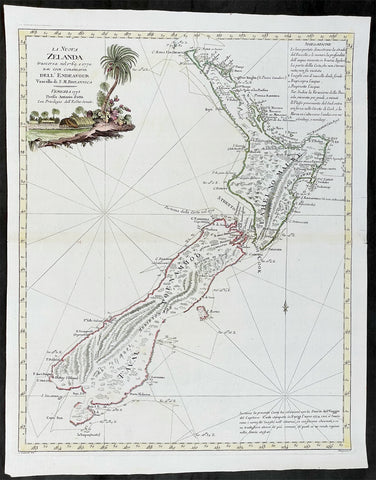
1778 Antonio Zatta Antique Map of New Zealand af. Captain James Cook - Beautiful
- Title : La Nuova Zelanda trascorsa nel 1769 e 1770 d'al Cook Comandante dell' Endeavour Vascello di S. M. Britannica . . . 1778
- Ref #: 93527
-
Condition: (A+) Fine Condition
- Size: 19 1/2in x 15 1/2in (495mm x 395mm)
- Date : 1778
Description:
This impressive original hand coloured copper-plate engraved very early antique map of New Zealand, after Captain James Cook, was engraved in 1778 (the first edition with a second dated 1791) was published by Antonio Zatta in his 1779 edition of Atlante Novissimo
This is a beautifully engraved map after Captain James Cooks surveys of 1769. Cook published the first compete map of NZ in 1774, with this more decorative map being published by Zatta some 4 years later. The map contains all of Cooks coastal survey detail with some details of the interior of the islands. Also included are the tracks of Cooks ship HMS Endeavour as he surveyed the coast as well as his approach and exit from New Zealand. Beautiful original hand colour, with a heavy impression denoting an early pressing.
The maps of Venetian publisher Antonio Zatta are noteworthy for their fine craftsmanship and high aesthetics. He was probably the most important Italian map publisher of the late eighteenth century and is responsible for a large number of atlases and single maps of considerable aesthetic and scientific merit.
General Definitions:
Paper thickness and quality: - Heavy and stable
Paper color : - off white
Age of map color: - Original
Colors used: - Yellow, green, blue, pink
General color appearance: - Authentic
Paper size: - 19 1/2in x 15 1/2in (495mm x 395mm)
Plate size: - 18in x 14in (455mm x 355mm)
Margins: - Min 1/2in (12mm)
Imperfections:
Margins: - None
Plate area: - None
Verso: - None
Background:
New Zealand (or Aotearoa, as the Maori call it) had been first encountered by Europeans in the early 1640s, when Dutch explorer Abel Tasman named the land "Nieuw Zeeland" after the Dutch province. Importantly, Tasman only sailed up the west coast of the North Island and had little notion as to the nature of the islands or their broader geographical context. A small number of Tasman's place names were preserved by Cook (and remain in place to this day), including 'Cape Maria van Diemen' (the northernmost point of the North Island) and the 'Three Kings' islets, where Cook and his men celebrated the Christmas of 1769-the first Europeans to visit the islands for nearly 130 years.
Captain James Cook (1728-1779) is considered to be the greatest explorer of the eighteenth century and was the finest maritime cartographer of the Age of Enlightenment. Having first worked on coal colliers and then distinguished himself as a surveyor in Eastern Canada, in 1768 he became the British Admiralty's choice to lead an unprecedented voyage of discovery. The central impetus for the expedition was to observe the Transit of Venus from Tahiti and then to proceed to explore Terra Australis Incognita, the supposedly rich southern continent. Whereas the first part of the voyage was to be conducted under the auspices of international scientific cooperation, the second part was entirely clandestine and was only communicated to Cook via "Secret Instructions" to be opened once at sea.
Cook's party left Plymouth in August 1768 aboard the converted coal collier HMS Endeavor and proceeded to Tahiti by way of Cape Horn. They arrived in time to observe the Transit of Venus, which occurred June 3, 1769. Cook then proceeded towards New Zealand, to the coordinates recorded by Tasman. As New Zealand was quite conceivably part of Terra Australis, it was Cook's intention to carefully explore and map the region.
On October 6, 1769, the Endeavor sighted the North Island (Te Ika a Maui) at Turanga Nui, which Cook renamed Poverty Bay. He and his crew had arrived on the opposite shore to where Tasman had met the island. Cook proceeded to the South Island (Te Wai Pounamu), carefully mapping both landmasses with a running survey. He used soundings, visual observations, and triangulation regulated by astronomical observations to create his manuscript charts.
Despite being constantly buffeted by wind and rain, and after having some hostile relations with the Maori that resulted in Maori deaths, Cook and his crew managed to circumnavigate both the North and South Islands, proving that they were separate islands divided by the Cook Strait. They also proved the islands were not connected to any southern continent. On March 31, 1770, Cook wrote in his journal that the Endeavour's voyage:
…must be allowed to have set a side the most, if not all, the arguments and proofs that have been advanced by different Authors to prove that there must be a Southern Continent; I mean to the northward of 40 degrees South, for what may lay to the Southward of that Latitude I know not (Cook, Journals I, 290).
The Endeavor left New Zealand at Cape Farewell, sailing west towards Australia, where Cook's crew would become the first Europeans to explore that region. In total, they had surveyed over 2,400 miles of New Zealand coastline in six months.
Upon the Endeavour's return to England in July 1771, Cook became a national hero. He would go on to lead two further voyages that would succeed in illuminating most of the Pacific Ocean to European eyes. On the second expedition, Cook would put to rest the myth of a southern continent. On the third, he kick started the fur trade in the Pacific Northwest of North America while searching for the Northwest Passage. He was killed by Hawaiians at Kealakekua Bay in 1779.
Cook returned to England with over 300 manuscript charts and coastal views. The original manuscript chart of New Zealand is now held by the British Library (Add MS 7085, f. 16-7). The chart was drawn, at least in part, by Isaac Smith (1752-1831), a draftsman of considerable skill who worked with Cook in Newfoundland, sailed on the Endeavour and Cook's second voyage, and was related to Cook's wife. Of the New Zealand chart, Cook wrote:
The Chart which I have drawn will best point out the figure and extent of these Islands…beginning at Cape Palliser and proceed round Aehei no mouwe (North Island) by the East Cape &ca. The Coast between these two Capes I believe to be laid down pretty accurate both in its figure and the Course and distance from point to point. The oppertunities I had and the methods I made use on to obtain these requesites were such as could hardly admit of an error… some few places however must be excepted and these are very doubtfull …(Cook, Journals I, 275-6)
The overall delineation is impressively accurate, correctly capturing many of the bays and promontories, and making insightful observations of the interior. Many of the names given by Cook survive to this day, including the Alps, (the great mountain chain of the South Island), Mount Egmont (the volcano on the North Island, also known as Mount Taranaki), the Bay of Islands, the Bay of Plenty, Hawke's Bay, and most intriguingly, Cape Kidnappers (a point on the North Island where Maori warriors attempted to abduct a member of the Endeavor's crew).
There are a few errors, conspicuous only because of the otherwise superb accuracy of the chart. Notably, Cook's "Banke's Island" is in fact a peninsula, part of the South Island. Further south, what looks like a possible peninsula is actually Stewart Island, with the "Isle Solander" to the west. Also, some portions of coast line remain un-surveyed due to adverse conditions or distraction. For example, the portion of coastline near Bankes Island is but a dotted line because Lieutenant Gore had thought he sighted land to the southeast. Upon sailing toward it, the promontory proved to be clouds. Despite such mistakes, the chart is remarkably thorough.
The present chart was printed as part of the official account of Cook's first voyage, which was edited by the literary critic John Hawkesworth and underwritten by the British Admiralty. An Account of the Voyages undertaken by the order of His Present Majesty for making Discoveries in the Southern Hemisphere… (London: W. Strahan and T. Cadell, 1773) recounted the voyages not only of Cook, but of Byron, Wallis, and Carteret who had also ventured to the Pacific for the Royal Navy earlier in the 1760s. It was engraved by John Abraham Bayly (fl. 1755-1794), a London-based engraver who specialized in cartographic work.
In 1816, the British Hydrographic Office began to reprint the map for its vessels. The chart was continuously consulted into the twentieth century. Due to this longevity, its extraordinary origins, and its important place in the founding of New Zealand as a British colony, Cook's chart is considered to be the most important single map in the history of New Zealand. Due to the complexity of the assignment and the great accuracy of the survey, it is also considered to be one of Cook's very finest maps, and one of the truly great achievements of Enlightenment cartography.
Zatta, Antonio fl. 1757 - 1797
Antonio Zatta was a prominent Italian editor, cartographer, and publisher. Little is known about his life beyond his many surviving published works. It is possible that he was born as early as 1722 and lived as late as 1804. He lived in Venice and his work flourished between 1757 and 1797. He is best known for his atlas, Atlante Novissimo (1779-1785), and for his prolific output of prints and books that were both precisely made and aesthetically pleasing. Zatta clearly had a large network from which to draw information; this is how he was able to publish the first glimpse of the islands visited by Captain Cook in the Atlante Novissimo.
Zattas maps are noteworthy for their fine craftsmanship and high aesthetics. His re-engraving and publication of John Mitchells famous map of North America A Map of the British and French Dominions in North America in 1778, is considered one of the best re-issues of this seminal, landmark map .
......He was probably the most important Italian map publisher of the late eighteenth century and is responsible for a large number of atlases and single maps of considerable aesthetic and scientific merit.... (Portinaro & Knirsch, The Cartography of North America, 1500-1800, p. 319).
Zatta was among the leaders in the eighteenth-century revival of fine printing in Italy and his choice of the text of Raynal to support his re-issue of Mitchells Map, is not surprising. Anne Palms Chalmers describes Zatta as a sardonic writer with the focus of a certain amount of political controversy (Venetian Book Design in the Eighteenth Century, The Metropolitan Museum of Art Bulletin, New Series, Vol. 29, No. 5, January 1971, pp. 226-235). Chalmers describes Zattas printing and design as harmonious in composition with ornament unified by style, quality of line, and tone of printing.
Please note all items auctioned are genuine, we do not sell reproductions. A Certificate of Authenticity (COA) can be issued on request.
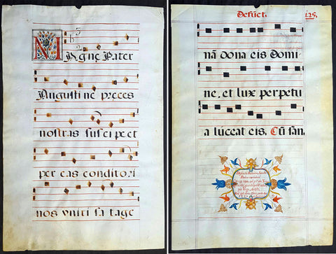
537 Large Vellum Latin Antiphonary Music Sheet Prayers to Dead & St Augustine
-
- Title : Desunctis Requiem, Sanctis Peanan Canemdum Coscripsi icopto, que pri edo, Tomo: Quem tibi, quandoquide robur, pia Virgo, dedisti Meq ipsu dono, cosecro, corde dico F.V.V.Z CICICXXXVII
- Ref #: 93521
- Size: 23 1/2in x 15 1/2in (595mm x 395mm)
- Date : 1537
- Condition: (A+) Fine Condition
Description:
This large beautifully hand written and hand coloured original antique vellum Latin Antiphonary Choro (choir) music sheet, with a separate chant on each side of the page. On the first side is the Prayer to the Dead and on the second side is a prayer to St Augustine. The page was hand scribed in 1537 and is dated, dates on these vellum Antiphonary Choro sheets was rarely done and is much sort after.
The two prayers set to music and sung as a Gregorian Chant, in part, translate as follows;
1. Requiem aeternam dona eis Domine; et lux perpetua luceat eis. Requiescant in pace. Amen.
(Eternal rest grant unto them, O Lord, and let perpetual light shine upon them. May they rest in peace. Amen)
2. Magne Pater Augustine, Preces nostras suscipe, Et per eas Conditori Nos placare satage, Atque rege gregem tuum Summum decus Praesulum
(Great Father Augustine, receive our prayers, and by them, seek thou to reconcile us to the Creator, and rule thy flock, o highest glory of bishops)
General Definitions:
Paper thickness and quality: - Heavy and stable
Paper color : - off white
Age of map color: - Original
Colors used: - Yellow, green, blue, pink
General color appearance: - Authentic
Paper size: - 23 1/2in x 15 1/2in (595mm x 395mm)
Plate size: - 23 1/2in x 15 1/2in (595mm x 395mm)
Margins: - Min 1/2in (12mm)
Imperfections:
Margins: - None
Plate area: - None
Verso: - None
Background:
Prayer for the dead is well documented within early Christianity, both among prominent Church Fathers and the Christian community in general. In Eastern Orthodoxy Christians pray for such souls as have departed with faith, but without having had time to bring forth fruits worthy of repentance. In the Catholic Church the assistance that the dead receive by prayer on their behalf is linked with the process of purification known as purgatory. While prayer for the dead continues in both these traditions and in those of Oriental Orthodoxy and of the Assyrian Church of the East, many Protestant groups reject the practice.
The tomb of the Christian Abercius of Hieropolis in Phrygia (latter part of the 2nd century) bears the inscription: Let every friend who observes this pray for me, i.e. Abercius, who throughout speaks in the first person.
The inscriptions in the Roman catacombs bear similar witness to the practice, by the occurrence of such phrases as:
Mayst thou live among the saints (3rd century);
May God refresh the soul of . . . ;
Peace be with them.
Among Church writers Tertullian († 230) is the first to mention prayers for the dead: The widow who does not pray for her dead husband has as good as divorced him. This passage occurs in one of his later writings, dating from the beginning of the 3rd century. Subsequent writers similarly make mention of the practice as prevalent, not as unlawful or even disputed (until Arius challenged it towards the end of the 4th century). The most famous instance is Saint Augustines prayer for his mother, Monica, at the end of the 9th book of his Confessions, written around 398.
An important element in the Christian liturgies both East and West consisted of the diptychs, or lists of names of living and dead commemorated at the Eucharist. To be inserted in these lists was a confirmation of ones orthodoxy, and out of the practice grew the official canonization of saints; on the other hand, removal of a name was a condemnation.
In the middle of the 3rd century, St. Cyprian enjoined that there should be no oblation or public prayer made for a deceased layman who had broken the Churchs rule by appointing a cleric trustee under his will: He ought not to be named in the priests prayer who has done his best to detain the clergy from the altar.
Although it is not possible, as a rule, to name dates for the exact words used in the ancient liturgies, yet the universal occurrence of these diptychs and of definite prayers for the dead in all parts of the Christian Church, East and West, in the 4th and 5th centuries shows how primitive such prayers were. The language used in the prayers for the departed is asking for rest and freedom from pain and sorrow. A passage from the Liturgy of St James reads:
Remember, O Lord, the God of Spirits and of all Flesh, those whom we have remembered and those whom we have not remembered, men of the true faith, from righteous Abel unto to-day; do thou thyself give them rest there in the land of the living, in thy kingdom, in the delight of Paradise, in the bosom of Abraham, Isaac and Jacob, our holy fathers, from whence pain and sorrow and sighing have fled away, where the light of thy countenance visiteth them and always shineth upon them.
Public prayers were only offered for those who were believed to have died as faithful members of the Church. But Saint Perpetua, who was martyred in 202, believed herself to have been encouraged in a vision to pray for her brother, who had died in his eighth year, almost certainly unbaptized; and a later vision assured her that her prayer was answered and he had been translated from punishment. St. Augustine thought it needful to point out that the narrative was not canonical Scripture, and contended that the child had perhaps been baptized.
Prayer to St Augustine: despite his overwhelming importance to Western theology, there was very little liturgical devotion to St Augustine in the Roman Rite during the first millenium. His feast does not appear in the majority of ancient liturgical books; his day was originally kept in Rome itself as that of an obscure martyr named Hermes, who is still celebrated as a commemoration on August 28th in the traditional rite. Towards the end of the eleventh century, however, as the great reform movement within the Western Church gained momentum, there emerged a huge number of new religious congregations of the sort which we now call canons regular, followed within a few generations by the mendicant friars. [1] Many of these, such as the Premonstratensians and Dominicans, took the Rule of St Augustine as their own, since it is very simple, and permitted a wide variety of adaptations and additional customs. Augustine himself then began to be honored in the liturgy as the great legislator of canonical life, just as St Benedict had long been honored as the great legislator of monastic life.
Sometime in the 12th century, a proper Office was composed for him, and widely adopted by many of the Augustinian orders in their various kinds. Here is the hymn which the Dominicans sing at Vespers and Matins, the Premonstratensians at Vespers and Lauds.
Antiphonary, Gregorian Choro
An Antiphonary is one of the liturgical books intended for use in choro (i.e. in the liturgical choir), and originally characterized, as its name implies, by the assignment to it principally of the antiphons used in various parts of the Roman liturgy.
Medieval antiphonaries varied with regional liturgical tradition. In 1570, following the Council of Trent, the Roman Antiphonary was declared universal. The Roman Antiphonary (Antiphonale Romanum) contains the chants for the Divine Office for the hours of Lauds, Prime, Terce, Sext, None, Vespers and Compline for every day of the year. The Vesperale Romanum is an excerpt of the Antiphonary containing the chants sung at Vespers. The music for use at the Mass is contained in the Roman Gradual (Graduale Romanum), the chants of the ordinary are also edited as an excerpt from the Gradual, the Kyriale Romanum. The Antiphonale Romanum was substantially revised in 1910/11 in the course of the reform of the Roman Breviary under Pope Pius X, notably restoring authentic Gregorian melodies. For the 1971 Liturgy of the Hours, there are two volumes, Antiphonale Romanum II and Liber Hymnarius.
The plainsong melodies found in the Roman antiphonary and the Graduale have received the general title of Gregorian Chant, in honour of pope Gregory the Great (r. 590–604), to whom a tradition, supported by internal and external evidence, ascribes the work of revising and collecting into the various texts and chants of the liturgy. Doubtless the ancient missal contained only those texts which were appointed for the celebrant, and did not include the texts which were to be chanted by the cantor and choir; and the Antiphonarium Missæ supplied the omitted texts for the choir as well as the chants in which the texts were to be sung. The importance of the Gregorian Antiphonary is found in the enduring stamp it impressed on the Roman liturgy.
Earlier popes had given, a medieval writer assures us, attention to the chants; and he specifies St. Damasus (d. 384), St. Leo (d. 461), St. Gelasius (d. 496), St. Symmachus (d. 514), St. John I (d. 526) and Boniface II (d. 532). It is true, also, that the chants used at Milan were styled, in honour of St. Ambrose (called the Father of Church Song), the Ambrosian Chant.
But it is not known whether any collection of the chants had been made before that of St. Gregory, concerning which his ninth-century biographer, John the Deacon, wrote: Antiphonarium centonem … compilavit. The authentic antiphonary mentioned by the biographer has not as yet been found. What was its character? What is meant by cento (patchwork)? In the century in which John the Deacon wrote his life of the Saint, a cento meant the literary feat of constructing a coherent poem out of scattered excerpts from an ancient author, in such wise, for example, as to make the verses of Virgil sing the mystery of the Epiphany. The work, then, of St. Gregory was a musical cento, a compilation (centonem ... compilavit) of pre-existing material into a coherent and well-ordered whole. This does not necessarily imply that the musical centonization of the melodies was the special and original work of the Saint, as the practice of constructing new melodies from separate portions of older ones had already been in vogue two or three centuries earlier than his day. But is it clear that the cento was one of melodies as well as of texts? In answer it might indeed by said that in the earliest ages of the Church the chants must have been so very simple in form that they could easily be committed to memory; and that most of the subsequently developed antiphonal melodies could be reduced to a much smaller number of types, or typical melodies, and could thus also be memorized.
And yet many say that it is scarcely credible that the developed melodies of St. Gregorys time had never possessed a musical notation, had never been committed to writing. What made his antiphonary so very useful to chanters (as John the Deacon esteemed it) was probably his careful presentation of a revised text with a revised melody, written either in the characters used by the ancient authors (as set down in Boethius) or in neumatic notation. We know that St. Augustine, sent to England by St. Gregory, carried with him a copy of the precious antiphonary, and founded at Canterbury a flourishing school of singing. That this antiphonary contained music we know from the decree of the Second Council of Cloveshoo (747) directing that the celebration of the feasts, in respect to baptism, Masses and music (in cantilenæ modo), should follow the method of the book which we received from the Roman Church. That this book was the Gregorian antiphonary is clear from the testimony of Egbert, Bishop of York (732-766), who in his De Institutione Catholica speaks of the Antiphonarium and Missale which the blessed Gregory … sent to us by our teacher, blessed Augustine.
It is impossible to trace here the progress of the Gregorian antiphonary throughout Europe, which resulted finally in the fact that the liturgy of Western Europe, with a very few exceptions, finds itself based fundamentally on the work of St. Gregory, whose labour comprised not merely the sacramentary, and the Antiphonarium Missæ, but extended also to the Divine Office. Briefly, the next highly important step in the history of the antiphonary was its introduction into some dioceses of France where the liturgy had been Gallican, with ceremonies related to those of Milan and with chants developed by newer melodies. From the year 754 may be dated the change in favour of the Roman liturgy. St. Chrodegang, Bishop of Metz, on his return from an embassy to Rome, introduced the Roman liturgy into his diocese and founded the Chant School of Metz. Subsequently, under Charlemagne, French monks went to Rome to study the Gregorian tradition there, and some Roman teachers visited France.
The interesting story of Ekkehard, concerning two monks, Petrus and Romanus, sent from Rome to teach chant, is not to be taken as historical. But a certain Petrus, according to Notker, was sent to Rome by Charlemagne and at the Abbey of St. Gall trained the monks in the Roman style. Besides Metz and St. Gall, other important schools of chant were founded at Rouen and Soissons. In the course of time new melodies were added, at first characterized by the simplicity of the older tradition, but gradually becoming more free in extended intervals. With respect to German manuscripts, the earliest are found in a style of neumatic notation different from that of St. Gall, while the St. Gall manuscripts are derived not directly from the Italian but from the Irish-Anglo-Saxon. It is probable that before the 10th and 11th centuries (at which period the St. Gall notation began to triumph in the German churches) the Irish and English missionaries brought with them the notation of the English antiphonary.
It would take too much space to record here the multiplication of antiphonaries and their gradual deterioration, both in text and in chant, from the Roman standard. The school of Metz began the process early. Commissioned by Louis the Pious to compile a Graduale and antiphonary, the priest Amalarius of Metz found a copy of the Roman antiphonary in the monastery of Corbie, and placed in his own compilation an M when he followed the Metz antiphonary, R when he followed the Roman, and an I C (asking Indulgence and Charity) when he followed his own ideas. His changes in the Graduale were few; in the antiphonary, many.
Part of the revision which, together with Elisagarus, he made in the responsories as against the Roman method, were finally adopted in the Roman antiphonary. In the 12th century, the commission established by St. Bernard to revise the antiphonaries of Citeaux criticized with undue severity the work of Amalarius and Elisagarus and withal produced a faulty antiphonary for the Cistercian Order. The multiplication of antiphonaries, the differences in style of notation, the variations in melody and occasionally in text, need not be further described here. In France especially, the multiplication of liturgies subsequently became so great, that when Dom Guéranger, in the middle of the 19th century, started introducing the Roman liturgy into that country, sixty out of eighty dioceses had their own local breviaries.
That the word antiphonarium is, or was, quite elastic in its application, is shown by the remark of Amalarius in his Liber de ordine Antiphonarii, written in the first half of the 9th century. The work which in Metz was called Antiphonarius was divided into three in Rome: What we call Graduale they style Cantatorius; and this, in accordance with their ancient custom, is still bound in a single volume in some of their churches. The remainder they divide into two parts: the one containing the responsories is called Responsoriale; while the other, containing antiphons, is called Antiphonarius. I have followed our custom, and have placed together (mixtim) the responsories and the antiphons according to the order of the seasons in which our feasts are celebrated (P. L., CV, 1245). The word cantatory explains itself as a volume containing chants; it was also called Graduale, because the chanter stood on a step (gradus) of the ambo or pulpit, while singing the response after the Epistle. Other ancient names for the antiphonary seem to have been Liber Officialis (Office Book) and Capitulare (a term sometimes used for the book containing the Epistles and Gospels).
Please note all items auctioned are genuine, we do not sell reproductions. A Certificate of Authenticity (COA) can be issued on request.
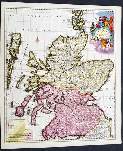
1708 Pieter Schenk Large Antique Map of Scotland - Beautiful Hand Colouring
- Title : Novissima Regni Scotia Septrionalis et Merdionalis Tabula
- Date : 1708
- Condition: (A+) Fine Condition
- Ref: 93524
- Size: 24 1/2in x 21in (620mm x 535mm)
Description:
This large original copper plate engraved beautifully hand coloured antique map of Scotland was engraved and published by Pieter Schenk in 1708 - dated in cartouche.
This is one of the finest and beautifully hand colored map of Scotland I have seen for sometime
General Definitions:
Paper thickness and quality: - Heavy and stable
Paper color : - off white
Age of map color: - Original
Colors used: - Yellow, green, blue, pink
General color appearance: - Authentic
Paper size: - 24 1/2in x 21in (620mm x 535mm)
Plate size: - 23 1/2in x 19 1/2in (595mm x 495mm)
Margins: - Min 1/2in (12mm)
Imperfections:
Margins: - None
Plate area: - None
Verso: - None
Background:
The Treaty of Perpetual Peace was signed in 1502 by James IV of Scotland and Henry VII of England. James married Henrys daughter, Margaret Tudor. James invaded England in support of France under the terms of the Auld Alliance and became the last British monarch to die in battle, at Flodden in 1513. In 1560, the Treaty of Edinburgh brought an end to the Anglo-French conflict and recognized the Protestant Elizabeth I as Queen of England. The Parliament of Scotland met and immediately adopted the Scots Confession, which signaled the Scottish Reformations sharp break from papal authority and Catholic teaching. The Catholic Mary, Queen of Scots was forced to abdicate in 1567.
In 1603, James VI, King of Scots inherited the thrones of the Kingdom of England and the Kingdom of Ireland in the Union of the Crowns, and moved to London. The military was strengthened, allowing the imposition of royal authority on the western Highland clans. The 1609 Statutes of Iona compelled the cultural integration of Hebridean clan leaders. With the exception of a short period under the Protectorate, Scotland remained a separate state, but there was considerable conflict between the crown and the Covenanters over the form of church government. The Glorious Revolution of 1688–89 saw the overthrow of King James VII of Scotland and II of England by the English Parliament in favour of William III and Mary II In common with countries such as France, Norway, Sweden and Finland, Scotland experienced famines during the 1690s. Mortality, reduced childbirths and increased emigration reduced the population of parts of the country about 10-15%.
In 1698, the Company of Scotland attempted a project to secure a trading colony on the Isthmus of Panama. Although it received a huge investment, the Darien scheme failed, partially due to English hostility. Along with the threat of an English invasion, the resulting bankruptcies played a leading role in convincing the Scots elite to back a union with England. On 22 July 1706, the Treaty of Union was agreed between representatives of the Scots Parliament and the Parliament of England. The following year twin Acts of Union were passed by both parliaments to create the united Kingdom of Great Britain with effect from 1 May 1707 with popular opposition and anti-union riots in Edinburgh, Glasgow, and elsewhere.
With trade tariffs with England now abolished, trade blossomed, especially with Colonial America. The clippers belonging to the Glasgow Tobacco Lords were the fastest ships on the route to Virginia. Until the American War of Independence in 1776, Glasgow was the worlds premier tobacco port, dominating world trade. The deposed Jacobite Stuart claimants had remained popular in the Highlands and north-east, particularly amongst non-Presbyterians, including Roman Catholics and Episcopalian Protestants. However, two major Jacobite risings launched in 1715 and 1745 failed to remove the House of Hanover from the British throne. The threat of the Jacobite movement to the United Kingdom and its monarchs effectively ended at the Battle of Culloden, Great Britains last pitched battle.
The Scottish Enlightenment and the Industrial Revolution turned Scotland into an intellectual, commercial and industrial powerhouse so much so Voltaire said We look to Scotland for all our ideas of civilisation. With the demise of Jacobitism and the advent of the Union, thousands of Scots, mainly Lowlanders, took up numerous positions of power in politics, civil service, the army and navy, trade, economics, colonial enterprises and other areas across the nascent British Empire. Historian Neil Davidson notes after 1746 there was an entirely new level of participation by Scots in political life, particularly outside Scotland. Davidson also states far from being peripheral to the British economy, Scotland – or more precisely, the Lowlands – lay at its core. In the Highlands, clan chiefs gradually started to think of themselves more as commercial landlords than leaders of their people. These social and economic changes included the first phase of the Highland Clearances and, ultimately, the demise of the clan system. In the last third of the 18th century, Highlanders began to migrate seasonally to Lowland cities for work, and emigration to the New World from both the Highlands and Lowlands became commonplace, even as the population increased
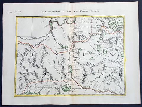
1778 Antonio Zatta & John Mitchell Antique Map of East Quebec & Western Ontario
- Title : La Parte Occidentale Della Nuova Francia o Canada
- Date : 1778
- Condition: (A+) Fine Condition
- Ref: 93512
- Size: 21in x 15 1/2in (535mm x 395mm)
Description:
Description:
This wonderfully executed original copper plate engraved hand coloured antique map of eastern Quebec and Western Ontario - from Lake Superior in the west to Montreal in the east and Hudson Bay in the North was published as Sheet 2, of 12, of Antonio Zattas 1778 re-issue of John Mitchells famous landmark map A Map of the British and French Dominions in North America, With the Roads, Distances, Limits, and Extent of the Settlements was published in Zattas Atlas Atlante Novissimo (1779-1785)
I have included an image of the complete 12 sheet joined map by Zatta as well as an image of Mitchells map.
General Definitions:
Paper thickness and quality: - Heavy and stable
Paper color : - off white
Age of map color: - Original
Colors used: - Yellow, green, blue, pink
General color appearance: - Authentic
Paper size: - 21in x 15 1/2in (535mm x 395mm)
Plate size: - 17 1/2in x 13 1/2in (445mm x 345mm)
Margins: - Min 1in (25mm)
Imperfections:
Margins: - None
Plate area: - None
Verso: - None
Background:
The Mitchell Map by John Mitchell (1711–1768) is considered the most famous map of North America both cartographically and historically, was reprinted several times during the second half of the 18th century. The Mitchell Map was used as a primary map source during the Treaty of Paris for defining the boundaries of the newly independent United States. The map remained important for resolving border disputes between the United States and Canada as recently as the 1980s dispute over the Gulf of Maine fisheries. The Mitchell Map is the most comprehensive map of eastern North America made during the colonial era. Its size is about 6.5 feet (2.0 m) wide by 4.5 feet (1.4 m) high.
John Mitchell was not a professional geographer or map-maker. Son of a wealthy Virginian family in Lancaster County, on Virginia's Northern Neck, he had been educated at Edinburgh University, Scotland; this education included the first two years of the three-year medical program. Returning to coastal Virginia, he practiced as a physician and studied the local botany. Ill health forced Mitchell and his wife to leave Virginia for London in 1746. There, he served as a consultant on exotic plants to noblemen interested in gardens. Also, it was there that Mitchell would make his famous map. Map historians have understandably been interested in why a physician and botanist who had shown no previous interest in map making should make such a large and detailed map.
Until recently, historians have argued that Mitchell was upset by the lack of interest shown by politicians in London about colonial affairs and so set out to warn them about the dangers posed to the British colonies by the French. Mitchell did so, on his own initiative, by making a first map of North America in 1750, which he then showed to the politicians he knew through his botanical and gardening activities. The map so impressed George Montagu-Dunk, 2nd Earl of Halifax, appointed president of the Board of Trade and Plantations in 1748, that Halifax opened up the official archives and solicited new maps from the colonies for Mitchell to make a new and better map. This was the map published in 1755. That is, the motive force for preparations against the French threat is understood to have come from a colonist who sought to take control of the colonies' future on behalf of the other colonists.
A re-examination of the archival evidence indicates, however, that Mitchell made his first map in 1750 at Halifax's behest. Halifax became president of the Board of Trade directly after the conclusion of the War of the Austrian Succession (1744–1748) and its North American component, King George's War. The war had ended in stalemate and a return to the Anglo-French status quo of the 1714 Treaty of Utrecht. In fact, it was a common conviction that it was only a matter of time before another global Anglo-French war would begin, and it was commonly expected that the spark of the new conflict would be the North American colonies. It was then that Halifax latched onto Mitchell as an expert informant on all things colonial; one of his requests, apparently, was for Mitchell to make a new map to show the territorial situation in North America. Certainly, it was only after 1749 that Mitchell's correspondence revealed his new interests in both geography and politics.
Mitchell compiled a first map in 1750 from the materials that he could find in London, in official archives and private hands. It proved to be inadequate. Halifax accordingly ordered the governors of the British colonies to send new maps, which most did. These became the basis, when fitted into the overall geographical frame provided by the maps of the French geographer Guillaume Delisle. Late in 1754, Halifax was using one manuscript copy of Mitchell's second map to successfully promote his political position (no compromise with the French) within the British cabinet in the build-up to the Seven Years' War aka French and Indian War. Halifax also permitted Mitchell to have the map published: it appeared in April 1755, engraved by Thomas Kitchin and published by Andrew Millar.
The published map bore the title A Map of the British and French Dominions in North America. It bore the copyright date of 13 February 1755, but the map was probably not sold to the public until April or even May. Minor corrections to the map's printing plates were made probably during the printing process.
The geographer John Green (né Braddock Mead) criticized Mitchell and his map soon after it appeared, emphasizing two failings with respect to Nova Scotia (an area of particular dispute with the French). Mitchell, Green noted, had used neither the astronomical observations for latitude and longitude made by Marquis Joseph Bernard de Chabert in the 1740s nor a 1715 chart of the Nova Scotia coast. In response, Mitchell released a new version of his map, now with two large blocks of text that described all of his data sources; the new version of the map also adjusted the coastline in line with Chabert's work but rejected the 1715 chart as deeply flawed. This version of the map, which Mitchell referred to as the "second edition," is commonly thought to have appeared sometime in 1757, but advertisements in the (London) Public Advertiser and Gazetteer and London Daily Advertiser on 23 April 1756 clearly indicate that this new map appeared at that time.
The map continued to be corrected and some boundaries updated, even after Mitchell's death in 1768.
Mitchell's map was printed in eight sheets; when assembled, it measures 136 cm by 195 cm (4 feet 6 inches by 6 feet 5 inches; height x width). The initial impressions printed in 1755 have a consistent coloring outlining British colonial claims. Mitchell extended the southern colonies across the entire continent, even over established Spanish territory west of the Mississippi. Mitchell divided up the Iroquois territories (as he understood them, reaching from Lake Champlain [Lac Irocoisia] to the Mississippi, and north of Lake Superior) between Virginia and New York, leaving only a much-reduced territory to the French.
Mitchell's map was expensive but it spawned many cheaper variants that trumpeted Halifax and Mitchell's powerful colonial vision to the British public. One of these, published in December 1755 by "a Society of Anti-Gallicans", restricted the French even further just to Quebec.
The map is liberally sprinkled with text describing and explaining various features, especially in regions that were relatively unknown or which were subject to political dispute. Many notes describe the natural resources and potential for settlement of frontier regions. Others describe Indian tribes. Many Indian settlements are shown, along with important Indian trails.
Since Mitchell's main objective was to show the French threat to the British colonies, there is a very strong pro-British bias in the map, especially with regard to the Iroquois. The map makes clear that the Iroquois were not just allies of Britain, but subjects, and that all Iroquois land was therefore British territory. Huge parts of the continent are noted as being British due to Iroquois conquest of one tribe or another. French activity within the Iroquois claimed lands is noted, explicitly or implicitly, as illegal.
In cases where the imperial claims of Britain and France were questionable, Mitchell always takes the British side. Thus many of his notes and boundaries seem like political propaganda today. Some of the claims seem to be outright falsehoods.
The map is very large and the notes are often very small, making it difficult to view online. Reduced scale copies result in unreadable notes. The following list gives a few examples of the kind of notes found on the map, with Mitchell's spelling:
- The region of today's central Tennessee and Kentucky (between the Tennessee and Cumberland Rivers): A Fine Level Fertile Country of great Extent, by Accounts of the Indians and our People
- In the area between the Mississippi River and the Tennessee River: This Country of the Cherokees which extends Westward to the Mississippi and Northward to the Confines of the Six Nations was formally surrendered to the Crown of Britain at Westminster 1729
- In the Great Plains: The Nadouessoians are reckoned one of the most Populous Nations of Indians in North America, altho' the number and situation of their Villages are not known nor laid down. (Reference to the Sioux)
- Along the coast of the Gulf of Mexico, present-day Texas: Wandering Savage Indians
- Southwest of Hudson Bay: The long and Barbarous Names lately given to some of these Northern Parts of Canada and the Lakes we have not inserted, as they are of no use, and uncertain Authority.
- North of Lake Huron: MESSESAGUES—Subdued by the Iroquois and now united with them making the 8th Nation in that League. (reference to the Mississaugas)
- Missouri River: Missouri River is reckoned to run Westward to the Mountains of New Mexico, as far as the Ohio does Eastward
- Present-day Iowa: Extensive Meadows full of Buffaloes
- Sandusky, Ohio: Sandoski—Canahogue—The seat of War, the Mart of Trade, & chief Hunting Grounds of the Six Nations, on the Lakes & the Ohio.
- Central Pennsylvania, north of present-day Harrisburg: St. Anthony's Wilderness
- Illinois region: The Antient Eriez were extirpated by the Iroquois upwards of 100 years ago, ever since which time they have been in Possession of L. Erie (reference to the Erie people)
- Along Illinois River and overland to the south end of Lake Michigan: Western Bounds of the Six Nations sold and Surrendered to Great Britain
- Illinois region: The Six Nations have extended their Territories to the River Illinois, ever since the Year 1672, when they subdued, and were incorporated with, the Antient Chaouanons, the Native Proprietors of these Countries, and the River Ohio. Besides which they likewise claim a Right of Conquest over the Illinois, and all the Mississippi as far as they extend. This is confirmed by their own Claims and Possessions in 1742, which include all the Bounds here laid down, and none have ever thought fit to dispute them. (reference to the Illiniwek)
- Just below the previous note: The Ohio Indians are a mixt Tribe of the Several Indians of our Colonies, settled here under the Six Nations, who have always been in Alliance and Subjection to the English. The most numerous of them are the Delaware and Shawnoes, who are Natives of Delaware River. Those about Philadelphia were called Sauwanoos whom we now call Shawanoes, or Shawnoes. The Mohickans and Minquaas were the Antient Inhabitants of Susquehanna R. (reference to the Lenape, Shawnee, and Susquehannock Indians)
- Southeast Missouri area: Mines of Marameg, which gave rise to the famous Mississippi Scheme 1719.
- North Florida: TIMOOQUA—Destroy'd by the Carolinians in 1706 (reference to the Timucua)
- South Georgia: COUNTRY OF THE APALACHEES—Conquered & surrendered to the Carolinians, after two memorable Victories obtain'd over them & the Spaniards in 1702 & 1703 at the Places marked thus [crossed-swords] (reference to the Apalachee)
- Alabama area: The English have Factories & Settlements in all the Towns of the Creek Indians of any note, except Albamas; which was usurped by the French in 1715 but established by the English 28 years before. (reference to the Creek people)
- Yazoo River: River of the Yasous—The Indians on this River were in Alliance with the English, for which they have been destroyed by the French (reference to the Yazoo tribe)
- Many geographic features are labeled with names no longer in use or oddly spelled, including:
Des Moines River: Moingona River
Kanawha and New River together: Gr. Conhaway called Wood R. or New R.
Kentucky River: Cuttawa or Catawba R.
Clinch River: Pelisipi River (a tributary is labeled Clinch's R.)
Tennessee River: River of the Cherakees, or Hogohegee R. Upstream another label says River Hogohegee or Callamaco
French Broad River: Agiqua R.
Little Tennessee River: Tannaſsee or Satico R.
Hiwassee River: Euphasee
Ohio River: Ohio or Splawacipiki R.
Altamaha River: Alatamaha or George R.
Minnesota River: Ouadebameniſsouté or R. St. Peter (reflecting the Dakota name Watpá Mnísota and the French name Rivière de St. Pierre)
Muskegon River: Maticon R.
The map also included non-existent features, such as Isle Phelipeaux in Lake Superior, found in earlier maps by Jacques-Nicolas Bellin.
The Mitchell Map remained the most detailed map of North America available in the later eighteenth century. Various impressions (and also French copies) were used to establish the boundaries of the new United States of America by diplomats at the 1783 Treaty of Paris that ended the American Revolutionary War. The map's inaccuracies subsequently led to a number of border disputes, such as in Maine. Its supposition that the Mississippi River extended north to the 50th parallel (into British territory) resulted in the treaty using it as a landmark for a geographically impossible definition of the border in that region. It was not until 1842, when the Webster-Ashburton Treaty resolved these inconsistencies with fixes such as the one that created Minnesota's Northwest Angle, that the U.S.–Canada border was clearly drawn from Maine to the Oregon Country.
Similarly, during the drafting of the Northwest Ordinance, the map's inaccuracy in depicting where an east–west line drawn through the southernmost point of Lake Michigan would intersect Lake Erie led to a long dispute over the Ohio–Michigan border that culminated in the Toledo War.
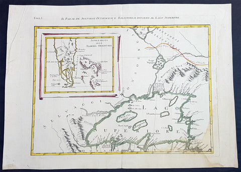
1778 Antonio Zatta & John Mitchell Antique Map of Lake Superior & Florida
- Title : Il Paese de Selvaggi Outauace si e Kilistinesi Intorno Al Lago Superiore; Supplemento alla Florida Orientale
- Date : 1778
- Condition: (A+) Fine Condition
- Ref: 93517
- Size: 21in x 15 1/2in (535mm x 395mm)
Description:
This wonderfully executed original copper plate engraved hand coloured antique map of Lake Superior, with an inset map of southern Florida, was published as Sheet 1, of 12, of Antonio Zattas 1778 re-issue of John Mitchells famous landmark map A Map of the British and French Dominions in North America, With the Roads, Distances, Limits, and Extent of the Settlements was published in Zattas Atlas Atlante Novissimo (1779-1785)
I have included an image of the complete 12 sheet joined map by Zatta as well as an image of Mitchells map.
General Definitions:
Paper thickness and quality: - Heavy and stable
Paper color : - off white
Age of map color: - Original
Colors used: - Yellow, green, blue, pink
General color appearance: - Authentic
Paper size: - 21in x 15 1/2in (535mm x 395mm)
Plate size: - 17 1/2in x 13 1/2in (445mm x 345mm)
Margins: - Min 1in (25mm)
Imperfections:
Margins: - None
Plate area: - None
Verso: - None
Background:
The Mitchell Map by John Mitchell (1711–1768) is considered the most famous map of North America both cartographically and historically, was reprinted several times during the second half of the 18th century. The Mitchell Map was used as a primary map source during the Treaty of Paris for defining the boundaries of the newly independent United States. The map remained important for resolving border disputes between the United States and Canada as recently as the 1980s dispute over the Gulf of Maine fisheries. The Mitchell Map is the most comprehensive map of eastern North America made during the colonial era. Its size is about 6.5 feet (2.0 m) wide by 4.5 feet (1.4 m) high.
John Mitchell was not a professional geographer or map-maker. Son of a wealthy Virginian family in Lancaster County, on Virginia's Northern Neck, he had been educated at Edinburgh University, Scotland; this education included the first two years of the three-year medical program. Returning to coastal Virginia, he practiced as a physician and studied the local botany. Ill health forced Mitchell and his wife to leave Virginia for London in 1746. There, he served as a consultant on exotic plants to noblemen interested in gardens. Also, it was there that Mitchell would make his famous map. Map historians have understandably been interested in why a physician and botanist who had shown no previous interest in map making should make such a large and detailed map.
Until recently, historians have argued that Mitchell was upset by the lack of interest shown by politicians in London about colonial affairs and so set out to warn them about the dangers posed to the British colonies by the French. Mitchell did so, on his own initiative, by making a first map of North America in 1750, which he then showed to the politicians he knew through his botanical and gardening activities. The map so impressed George Montagu-Dunk, 2nd Earl of Halifax, appointed president of the Board of Trade and Plantations in 1748, that Halifax opened up the official archives and solicited new maps from the colonies for Mitchell to make a new and better map. This was the map published in 1755. That is, the motive force for preparations against the French threat is understood to have come from a colonist who sought to take control of the colonies' future on behalf of the other colonists.
A re-examination of the archival evidence indicates, however, that Mitchell made his first map in 1750 at Halifax's behest. Halifax became president of the Board of Trade directly after the conclusion of the War of the Austrian Succession (1744–1748) and its North American component, King George's War. The war had ended in stalemate and a return to the Anglo-French status quo of the 1714 Treaty of Utrecht. In fact, it was a common conviction that it was only a matter of time before another global Anglo-French war would begin, and it was commonly expected that the spark of the new conflict would be the North American colonies. It was then that Halifax latched onto Mitchell as an expert informant on all things colonial; one of his requests, apparently, was for Mitchell to make a new map to show the territorial situation in North America. Certainly, it was only after 1749 that Mitchell's correspondence revealed his new interests in both geography and politics.
Mitchell compiled a first map in 1750 from the materials that he could find in London, in official archives and private hands. It proved to be inadequate. Halifax accordingly ordered the governors of the British colonies to send new maps, which most did. These became the basis, when fitted into the overall geographical frame provided by the maps of the French geographer Guillaume Delisle. Late in 1754, Halifax was using one manuscript copy of Mitchell's second map to successfully promote his political position (no compromise with the French) within the British cabinet in the build-up to the Seven Years' War aka French and Indian War. Halifax also permitted Mitchell to have the map published: it appeared in April 1755, engraved by Thomas Kitchin and published by Andrew Millar.
The published map bore the title A Map of the British and French Dominions in North America. It bore the copyright date of 13 February 1755, but the map was probably not sold to the public until April or even May. Minor corrections to the map's printing plates were made probably during the printing process.
The geographer John Green (né Braddock Mead) criticized Mitchell and his map soon after it appeared, emphasizing two failings with respect to Nova Scotia (an area of particular dispute with the French). Mitchell, Green noted, had used neither the astronomical observations for latitude and longitude made by Marquis Joseph Bernard de Chabert in the 1740s nor a 1715 chart of the Nova Scotia coast. In response, Mitchell released a new version of his map, now with two large blocks of text that described all of his data sources; the new version of the map also adjusted the coastline in line with Chabert's work but rejected the 1715 chart as deeply flawed. This version of the map, which Mitchell referred to as the "second edition," is commonly thought to have appeared sometime in 1757, but advertisements in the (London) Public Advertiser and Gazetteer and London Daily Advertiser on 23 April 1756 clearly indicate that this new map appeared at that time.
The map continued to be corrected and some boundaries updated, even after Mitchell's death in 1768.
Mitchell's map was printed in eight sheets; when assembled, it measures 136 cm by 195 cm (4 feet 6 inches by 6 feet 5 inches; height x width). The initial impressions printed in 1755 have a consistent coloring outlining British colonial claims. Mitchell extended the southern colonies across the entire continent, even over established Spanish territory west of the Mississippi. Mitchell divided up the Iroquois territories (as he understood them, reaching from Lake Champlain [Lac Irocoisia] to the Mississippi, and north of Lake Superior) between Virginia and New York, leaving only a much-reduced territory to the French.
Mitchell's map was expensive but it spawned many cheaper variants that trumpeted Halifax and Mitchell's powerful colonial vision to the British public. One of these, published in December 1755 by "a Society of Anti-Gallicans", restricted the French even further just to Quebec.
The map is liberally sprinkled with text describing and explaining various features, especially in regions that were relatively unknown or which were subject to political dispute. Many notes describe the natural resources and potential for settlement of frontier regions. Others describe Indian tribes. Many Indian settlements are shown, along with important Indian trails.
Since Mitchell's main objective was to show the French threat to the British colonies, there is a very strong pro-British bias in the map, especially with regard to the Iroquois. The map makes clear that the Iroquois were not just allies of Britain, but subjects, and that all Iroquois land was therefore British territory. Huge parts of the continent are noted as being British due to Iroquois conquest of one tribe or another. French activity within the Iroquois claimed lands is noted, explicitly or implicitly, as illegal.
In cases where the imperial claims of Britain and France were questionable, Mitchell always takes the British side. Thus many of his notes and boundaries seem like political propaganda today. Some of the claims seem to be outright falsehoods.
The map is very large and the notes are often very small, making it difficult to view online. Reduced scale copies result in unreadable notes. The following list gives a few examples of the kind of notes found on the map, with Mitchell's spelling:
- The region of today's central Tennessee and Kentucky (between the Tennessee and Cumberland Rivers): A Fine Level Fertile Country of great Extent, by Accounts of the Indians and our People
- In the area between the Mississippi River and the Tennessee River: This Country of the Cherokees which extends Westward to the Mississippi and Northward to the Confines of the Six Nations was formally surrendered to the Crown of Britain at Westminster 1729
- In the Great Plains: The Nadouessoians are reckoned one of the most Populous Nations of Indians in North America, altho' the number and situation of their Villages are not known nor laid down. (Reference to the Sioux)
- Along the coast of the Gulf of Mexico, present-day Texas: Wandering Savage Indians
- Southwest of Hudson Bay: The long and Barbarous Names lately given to some of these Northern Parts of Canada and the Lakes we have not inserted, as they are of no use, and uncertain Authority.
- North of Lake Huron: MESSESAGUES—Subdued by the Iroquois and now united with them making the 8th Nation in that League. (reference to the Mississaugas)
- Missouri River: Missouri River is reckoned to run Westward to the Mountains of New Mexico, as far as the Ohio does Eastward
- Present-day Iowa: Extensive Meadows full of Buffaloes
- Sandusky, Ohio: Sandoski—Canahogue—The seat of War, the Mart of Trade, & chief Hunting Grounds of the Six Nations, on the Lakes & the Ohio.
- Central Pennsylvania, north of present-day Harrisburg: St. Anthony's Wilderness
- Illinois region: The Antient Eriez were extirpated by the Iroquois upwards of 100 years ago, ever since which time they have been in Possession of L. Erie (reference to the Erie people)
- Along Illinois River and overland to the south end of Lake Michigan: Western Bounds of the Six Nations sold and Surrendered to Great Britain
- Illinois region: The Six Nations have extended their Territories to the River Illinois, ever since the Year 1672, when they subdued, and were incorporated with, the Antient Chaouanons, the Native Proprietors of these Countries, and the River Ohio. Besides which they likewise claim a Right of Conquest over the Illinois, and all the Mississippi as far as they extend. This is confirmed by their own Claims and Possessions in 1742, which include all the Bounds here laid down, and none have ever thought fit to dispute them. (reference to the Illiniwek)
- Just below the previous note: The Ohio Indians are a mixt Tribe of the Several Indians of our Colonies, settled here under the Six Nations, who have always been in Alliance and Subjection to the English. The most numerous of them are the Delaware and Shawnoes, who are Natives of Delaware River. Those about Philadelphia were called Sauwanoos whom we now call Shawanoes, or Shawnoes. The Mohickans and Minquaas were the Antient Inhabitants of Susquehanna R. (reference to the Lenape, Shawnee, and Susquehannock Indians)
- Southeast Missouri area: Mines of Marameg, which gave rise to the famous Mississippi Scheme 1719.
- North Florida: TIMOOQUA—Destroy'd by the Carolinians in 1706 (reference to the Timucua)
- South Georgia: COUNTRY OF THE APALACHEES—Conquered & surrendered to the Carolinians, after two memorable Victories obtain'd over them & the Spaniards in 1702 & 1703 at the Places marked thus [crossed-swords] (reference to the Apalachee)
- Alabama area: The English have Factories & Settlements in all the Towns of the Creek Indians of any note, except Albamas; which was usurped by the French in 1715 but established by the English 28 years before. (reference to the Creek people)
- Yazoo River: River of the Yasous—The Indians on this River were in Alliance with the English, for which they have been destroyed by the French (reference to the Yazoo tribe)
- Many geographic features are labeled with names no longer in use or oddly spelled, including:
Des Moines River: Moingona River
Kanawha and New River together: Gr. Conhaway called Wood R. or New R.
Kentucky River: Cuttawa or Catawba R.
Clinch River: Pelisipi River (a tributary is labeled Clinch's R.)
Tennessee River: River of the Cherakees, or Hogohegee R. Upstream another label says River Hogohegee or Callamaco
French Broad River: Agiqua R.
Little Tennessee River: Tannaſsee or Satico R.
Hiwassee River: Euphasee
Ohio River: Ohio or Splawacipiki R.
Altamaha River: Alatamaha or George R.
Minnesota River: Ouadebameniſsouté or R. St. Peter (reflecting the Dakota name Watpá Mnísota and the French name Rivière de St. Pierre)
Muskegon River: Maticon R.
The map also included non-existent features, such as Isle Phelipeaux in Lake Superior, found in earlier maps by Jacques-Nicolas Bellin.
The Mitchell Map remained the most detailed map of North America available in the later eighteenth century. Various impressions (and also French copies) were used to establish the boundaries of the new United States of America by diplomats at the 1783 Treaty of Paris that ended the American Revolutionary War. The map's inaccuracies subsequently led to a number of border disputes, such as in Maine. Its supposition that the Mississippi River extended north to the 50th parallel (into British territory) resulted in the treaty using it as a landmark for a geographically impossible definition of the border in that region. It was not until 1842, when the Webster-Ashburton Treaty resolved these inconsistencies with fixes such as the one that created Minnesota's Northwest Angle, that the U.S.–Canada border was clearly drawn from Maine to the Oregon Country.
Similarly, during the drafting of the Northwest Ordinance, the map's inaccuracy in depicting where an east–west line drawn through the southernmost point of Lake Michigan would intersect Lake Erie led to a long dispute over the Ohio–Michigan border that culminated in the Toledo War.

1613 Mercator Antique Map of America & The Great Southern Land - Terra Australis
- Title : America sive India Nova. ad magna Gerardi Mercatoris aui Universalis imitationem in compendium redacta. Per Michaelem Mercatorem Duysburgensem
- Ref #: 61033
- Size: 20 1/2in x 17 1/2in (510mm x 445mm)
- Date : 1613
- Condition: (A+) Fine Condition
Description:
This fine beautifully hand coloured original antique early map of America and the Great Southern Continent (Terra Australis) that was envisaged in the southern Hemisphere, prior to the discovery of Australia by Captain Cook in 1769 - the only map attributed to Gerard Mercator's Grandson Michael - was published in the 1633 French edition of Mercator's Atlas.
This map is magnificent with beautiful original hand colouring, wide margins and stable paper. Backed with transparent archival Japanese paper. Original colouring such as this is scarce and hard to find.
Condition Report:
Paper thickness and quality: - Heavy and stable
Paper color: - off white
Age of map color: - Original
Colors used: - Yellow, red, green, orange, blue
General color appearance: - Authentic
Paper size: - 21 1/2in x 17 3/4in (545mm x 450mm)
Plate size: - 18 1/2in x 14 3/4in (470mm x 376mm)
Margins: - Min 1in (25mm)
Imperfections:
Margins: - Light soiling in margins
Plate area: - None
Verso: - None
Background: Largely based on Rumold Mercator's world map of 1587, this map aptly reflects 16th-century knowledge, theories and suppositions regarding the New World. Naturally, most of this new knowledge was coastal, and configurations of any large areas were greatly hampered by the lack of a sound means of determining longitude. Nevertheless, the collective accomplishment of explorers and mapmakers represented in this map is astounding, showing in a generally correct way the vast extent of the New World. "A few of the most famous theories are still present: a large inland lake in Canada, two of the four islands of the North Pole, a bulge to the west coast of South America and the large southern continent" (Burden).
The map appeared in 1595 and 1606 editions of the Atlantis Pars Altera , after which the plate was sold to Jodocus Hondius, who reissued the maps in varying editions through 1639. The present example includes French text on verso, confirming it to be a Hondius issue.
Several of the more fascinating theories are present, including the multiple islands of the North Polar Sea, bulging South America and vast unknown southern continent. The St. Lawrence crosses half the continent. No sign of the English in Virginia. The search for a water course across North America is interupted only by some mid-continental mountains. Evidence of the Spanish explorations in the Southwest is present and the Colorado and Gila Rivers already reflect a good knowledge of this area, as does the peninsular Baja California, based upon Uloa's work.
The depiction of the NW Passage and Western North America are also of great interest. Annotations reference the voyages of Columbus and Magellan.(Ref: Burden; Koeman; Tooley; M&B)
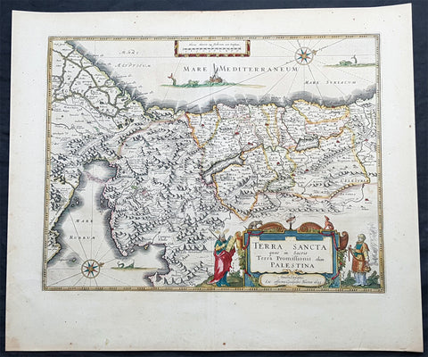
1629 Willem Blaeu Antique Map of the Holy Land Palestine Jerusalem Twleve Tribes
- Title : Terra Sancta quae in Sacris Terra Promissionis olim Palestina....Guiljesmi Blaeuw 1629
- Date : 1629
- Condition: (A+) Fine Condition
- Ref: 93509
- Size: 23 1/2in x 20in (590mm x 495mm)
Description:
This magnificent original copper plate engraved antique map of the Holy Land, Terra Sancta, Palestine was one of the very few dated maps printed by Willem Blaeu. The map was engraved by Jodocus Hondius the younger and published by Willem Blaeu in the 1643 French edition of Atlas Novus.
General Definitions:
Paper thickness and quality: - Heavy and stable
Paper color : - off white
Age of map color: - Original
Colors used: - Blue, pink, red, green, yellow
General color appearance: - Authentic
Paper size: - 23 1/2in x 20in (590mm x 495mm)
Plate size: - 20in x 15 1/4in (505mm x 384mm)
Margins: - Min 1in (25mm)
Imperfections:
Margins: - None
Plate area: - None
Verso: - None
Background:
This is one of the very few maps published in Blaeus Atlas that bears a date. It was actually made by Jodocus Hondius the younger in 1629, but was not printed until after the plate was purchased by Willem Blaeu (who added his imprint in the lower part of the cartouche)
At this time, many of the maps of Palestine were oriented to show the east at the top to focus on Jerusalem. Here, the orientation is inverted so that Blaeus map shows Palestine as it might have been viewed by Moses from the top of Mt Pisgah. The decorative features are Old Testament in inspiration: Moses holding the Tablets of the Law, stands to the left of the cartouche, Aaron to the right, while in the Mediterranean Jonah is about to be swallowed by the whale and in the Sinai is shown the route of the Exodus. In the Red Sea at Yam Suf, Pharaohs armies are shown drowning. The lands of the Twelve Tribes are shown straddling both banks of the Jordan and the city of Jerusalem can be seen occupying a place of honour in the upper centre of the map.
The geographical detail of the map is taken from an large inset on a large map of Palestine by the traveller Pieter Laicksteen and the mapmaker to Phillip II of Spain, Christian s Grooten, published at Antwerp in 1570. This inset map, its importance recognised by Hondius and by Blaeu, was unorthodox in its treatment of the outline of the Red Sea and its triangular outline for the Sinai peninsula - lone before either was finally admitted by mapmakers as more accurate than traditionally accepted versions.
The Blaeus retained this map for all editions of the firms atlas for more than thirty years from 1630, even though the rival publisher Johannes Jansson issued a more detailed seven sheet map of the region in his own atlas.
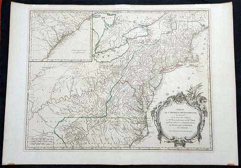
1768 Robert De Vaugondy Large Antique 2nd edition Map of Colonial United States
- Title : Partie De L Amerique Septentrionale, qui Comprend Le Cours De L Ohio...Par le Sr Robert de Vaugondy
- Date : 1768
- Condition: (A+) Fine Condition
- Ref: 93504
- Size: 30in x 21in (760mm x 550mm)
Description:
This large original beautifully hand coloured, scarce 2nd edition antique map of the east coast of the United States, illustrating the course of the Ohio River and stretching from New England to the Carolinas, north to the Great Lakes and south to the Mississippi - with an inset map of The Carolinas - was published in 1768 by Robert Du Vaugondy in his Atlas Universal.
This is one of the best examples of this map I have seen, beautiful hand colour on age toned heavy paper with original margins with a heavy dark ink denoting an early pressing.
General Definitions:
Paper thickness and quality: - Heavy and stable
Paper color : - off white
Age of map color: - Original & later
Colors used: - Yellow, green, blue, pink
General color appearance: - Authentic
Paper size: - 30in x 22in (760mm x 560mm)
Plate size: - 25in x 19 1/2in (635mm x 495mm)
Margins: - Min 1in (25mm)
Imperfections:
Margins: - None
Plate area: - None
Verso: - None
Background:
Second state of the early de Vaugondy map of the British colonies, with changes after the 1763 Treaty of Paris, with Virginia & Carolina extended to the Mississippi and Pennsylvania extended to Lake Erie. The majority of geographical information is based upon John Mitchells great map of North America from the mid 1750s, also drawing from Lewis, Evans on the Middle British Colonies and Joshua Frys and Peter Jeffersons map of Virginia and Maryland. The Mitchell map was the culmination of many years of British surveying in the North American Colonies and was considered one of the best maps of the continent available to Europeans and Americans in the mid-eighteenth century.
De Vaugondys rendition does not copy the full scope of Mitchells map but instead focuses on the colonies stretching from southern Maine to the Carolinas. In the top left corner is an inset of South Carolina and Georgia. De Vaugondy also pays special attention to the river systems and settlements. This map shows some of the earliest accurate information of the trans-Allegheny regions (the Ohio River, Kentucky, Tennessee and Parts of Ohio) and inland areas to the southeast of the Great Lakes and interior of New England.
Maine is still part of the Massachusetts Bay Colony. During this era. The dispute between New Hampshire and New York over who controlled the area which is now Vermont has been resolved. The outbreak of the French & Indian War (Seven Years War) briefly suspended interest in the disputed area, and it was not until 1764 that the British crown upheld New Yorks claim to Vermont. Included is a beautiful title cartouche in the Rococo style. (Ref: Tooley; M&B)
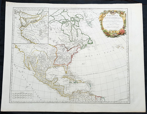
1783 R. De Vaugondy Large Antique 1st Post Revolutionary Map of North America
- Title : Amerique Septentrionale ...Les Etats Unis...1783...Robert De Vaugondy
- Ref #: 93503-1
- Size: 27 1/2in x 21 1/2in (700mm x 540mm)
- Date : 1783
- Condition: (A+) Fine Condition
Description:
This large original beautifully hand coloured copper plate antique map of post revolutionary North America & the newly form United States was engraved in 1783 - dated - and was published by Robert De Vaugondy in his large elephant folio Atlas Universal
This map is in beautiful original condition, original margins, original outline colour on strong sturdy paper with a heavy impression. A must for any collector of maps of historical importance.
General Definitions:
Paper thickness and quality: - Heavy and stable
Paper color : - off white
Age of map color: - Original
Colors used: - Blue, pink, red, green, yellow
General color appearance: - Authentic
Paper size: - 27 1/2in x 21 1/2in (700mm x 540mm)
Plate size: - 25 1/2in x 18 1/2in (650mm x 465mm)
Margins: - Min 1in (25mm)
Imperfections:
Margins: - None
Plate area: - None
Verso: - None
Background:
This is Robert De Vaugondys 5th State of his North America map and one of the first to show the newly liberated American States, after the American Revolutionary War 1775 - 1783.
The maps includes an engraved borderline for the newly founded United States as agreed upon by the Treaty of Paris in 1783. Also, the maps title was altered from earlier states to incorporate the name (in French) for the United States, Etats Unis, which also appears on the map itself. This state includes much other new information along with the place names that were added to the previous state, such as the Newport, New York City, and Bermuda. Florida is shown as an archipelago and the coastline of California is quite curious, with a continuation of the coastline in the inset map of the Northwest showing some of the mythical cartography, such as the Sea of the West and River of the West, which were debated among map scholars and explorers until Captain James Cook dispelled these myths in his three Voyages to the Pacific.
The map also locates the area identified as Fou-sang, reflecting the belief that Chinese mariners may have reached America, the location of the mythical colony of Fou-sang. According to some historians such as Charles Godfrey Leland and Joseph de Guignes ( Le Fou-Sang des Chinois est-il lAmérique Mémoires de lAcadémie des Inscriptions et Belles Lettres, tome 28, Paris, 1761), the distances given by Hui Shen (20,000 Chinese li) would locate Fou-sang on the west coast of the American continent, near British Columbia.
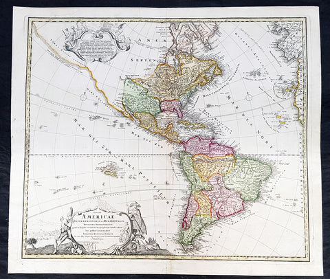
1720 Johannes Baptist Homann Large Antique Map of America
- Title : Totius Americae Septentrionalis et Meridionalis Novissima Representatio quam ex fingulis Geographorum Tabulis collecta luci publicae accommodavit...Johannes Baptista Homann
- Ref #: 93506
- Size: 24in x 21in (610mm x 525mm)
- Date : 1720
- Condition: (A+) Fine Condition
Description:
This large original beautifully hand coloured copper plate antique map of America was published by Johann Baptist Homann in 1720.
A very nice example of this early landmark American map by one of the greats of 17th & 18th century German cartography.
General Definitions:
Paper thickness and quality: - Heavy and stable
Paper color : - off white
Age of map color: - Original
Colors used: - Blue, pink, red, green, yellow
General color appearance: - Authentic
Paper size: - 24in x 21in (610mm x 525mm)
Plate size: - 22 1/2in x 19in (565mm x 490mm)
Margins: - Min 1in (25mm)
Imperfections:
Margins: - None
Plate area: - None
Verso: - Bottom centerfold rejoined at bottom of map, not affecting the image
Background:
This is the second state of Homanns map of America that includes an elongated northwest Coastline is called Costa Terrae Borealis incognitae detecta a Dom: Ioanne de Gama navigante ex China in Novam Hispaniam. The map provides credit for the discovery of this coastline to João de Gama (1540-1591). João da Gama, the grandson of Vasco da Gama, was a Portuguese explorer and colonial administrator in the Far East, during the last quarter of the 16th century. Da Gama sailed from Macau to the northeast and rounded Japan by north, crossing the Pacific Ocean at the northernmost latitudes. The lands northeast of Japan, which João da Gama discovered, were the subject of legend and speculation in the centuries that followed, inspiring its search by European powers.
Good detail throughout the map, especially in the southwest and near the Great Lakes, which were then actively being explored by the French fur traders and Hudson\'s Bay Company.
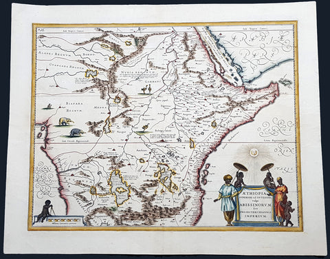
1646 Joan Blaeu Antique Map of Central and NE Africa - Land of Prestor John
- Title : Aethiopia Superior vel interior vulgo Abissinorum sive Presbiteri Joannnis Imperium...
- Ref #: 93510
- Size: 23in x 18in (585mm x 475mm)
- Date : 1646
- Condition: (A+) Fine Condition
Description:
This original hand coloured copper-plate engraved antique map of Central and NE Africa - the mythical land of Emperor Prestor John - was published in the 1645 Latin Edition of edition of Joan Blaeus Atlas Novus.
General Definitions:
Paper thickness and quality: - Heavy and stable
Paper color : - off white
Age of map color: - Original
Colors used: - Blue, pink, red, green, yellow
General color appearance: - Authentic
Paper size: - 23in x 18in (585mm x 475mm)
Plate size: - 19 1/2in x 15 1/4in (495mm x 390mm)
Margins: - Min 1in (25mm)
Imperfections:
Margins: - None
Plate area: - None
Verso: - None
Background:
Rumours of the mythical Emperor Prestor John began in Europe around 1150AD, that somewhere in Asia there was a powerful Christian Emperor named Presbyter Johannes (with the court title of Gurkhan), who had founded the kingdom of Kara Khitai. He had broken the power of the Musselman in his own domain after a fierce and bloody fight. The mysterious Priest-King became a symbol of hope in the Christian world beset by Mongol hordes. Pope Alexander III resolved to make contact with Presbyter John, and his first step was to address a letter to him (dated 27th September 1177). The Pope\'s physician was dispatched to deliver the letter in person. He never returned. Pope Innocent IV was even more determined than his predecessor, and decided to convert the Barbarians instead of conquer them. Dominican and Franciscan missionaries as well as civil ambassadors of peace plodded back and forth between the Pope, the King of France and the Mogul Khan. These travelers soon learned that His Highness Presbyter Johannes and the Christian kingdom in deepest Asia were popular myths. But the popular fancy was not easily dispelled, and instead of allowing the bubble to be punctured, the people merely transferred the kingdom of Presbyter John to Africa - especially Abyssinia. No-one knew very much about Abyssinia. A few die hards like John de Plano Carpini and Marco Polo persisted in the belief that Presbyter John still reigned in his splendor deep in the heart of the Orient. On the larger map in Higdens Polychronicon the empire of Presbyter John was located in the lower Scythia within the limits of Europe, but the map of Marino Sanuto it was placed in further India. It was moved again to Central Asia and ended up in Abyssinia. The legend persisted, however, and four hundred years after Pope Alexander III wrote his letter to Presbyter Johannes, Abraham Ortelius, a Dutch map publisher issued a separate map titled Presbyteri Johannis Siv Abissinorum Iperii Descripto. (Ref: M&B, Tooley; Norwich)

1759 Delarochette & Kitchin 1st Edition Antique Map of Germany Central Europe - Rare
- Titles: Map of the Empire of Germany, Including All the States Comprehend under that name: with the Kingdom of Priussia &c.
Sizes: 48 1/2in x 41in (1.230m x 1.040m) - Condition: (A+) Fine Condition
- Date: 1759
- Ref #: 93418
Description:
This stunning very large, scare and original copper-plate engraved antique 1st edition wall map of Germany, Bohemia, Austria, Prussia, Poland, Hungary, Netherlands and Northern Italy by the English cartographers Louis d arcy Delarochette & Thomas Kitchin (engraver) was published by Robert Sayer in 1759.
Incredibly detailed map of central Europe showing political boundaries as they were in the mid 18th century. Much detail noting roadways, towns, castles, monasteries, forests, swamps, rivers, towns, cities, mountains and much more. An incredible insight into mid 18th century Europe.
General Definitions:
Paper thickness and quality: - Heavy and stable
Paper color : - off white
Age of map color: - Original
Colors used: - Yellow, green, blue, pink
General color appearance: - Authentic
Paper size: - 48 1/2in x 41in (1.230m x 1.040m)
Plate size: - 48 1/2in x 41in (1.230m x 1.040m)
Margins: - Min 1/2in (12mm)
Imperfections:
Margins: - None
Plate area: - None
Verso: - None
Background:
Louis d Arcy Delarochette 1731 - 1802 was a British cartographer active in the mid to late 18th century. Collaborated with many famous British cartographers including Kitchin, Faden, Laurie & Whittle and Thomas Jefferies. Well know for his large scale maps.
Robert Sayers 1724 - 1794 was an important English map publisher and engraver active from the mid to late 18th century. Sayer was born in Sunderland, England, in 1725. He may have clerked as a young man with the Bank of England, but this is unclear. His brother, James Sayer, married Mary Overton, daughter-in-law of John Overton and widow of Philip Overton. Sayer initially worked under Mary Overton, but by December of 1748 was managing the Overton enterprise and gradually took it over, transitioning the plates to his own name. When Thomas Jefferys went bankrupt in 1766, Sayer offered financial assistance to help him stay in business and, in this way, acquired rights to many of the important Jefferys map plates as well as his unpublished research. From about 1774, he began publishing with his apprentice, John Bennett (fl. 1770-1784), as Sayer and Bennett, but the partnership was not formalized until 1777. Bennett retired in 1784 following a mental collapse and the imprint reverted to Robert Sayer. From 1790, Sayer added Robert Laurie and James Whittle to his enterprise, renaming the firm Robert Sayer and Company. Ultimately, Laurie and Whittle partnered to take over his firm. Sayer retired to Bath, where, after a long illness, he died. During most of his career, Sayer was based at 53 Fleet Street, London. His work is particularly significant for its publication of many British maps relating to the American Revolutionary War. Unlike many map makers of his generation, Sayer was a good businessman and left a personal fortune and great estate to his son, James Sayer, who never worked in the publishing business.
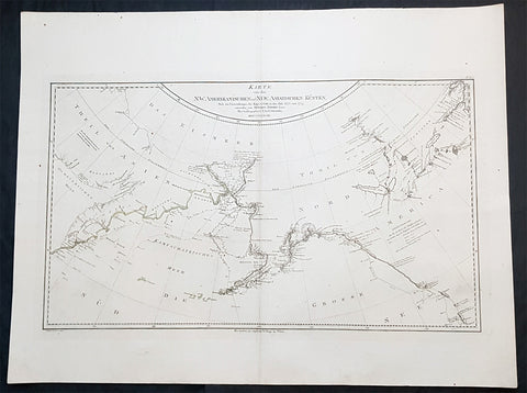
1788 Franz Schraembl & Capt Cook Large Antique Map NW America Alaska, California
- Title : Karte von den N.W. Amerikanischen und N.OE. Asiatischen Kusten nach den Untersuchungen des Kapit. Cook in den Jah. 1778 und 1779
- Ref #: 93436
- Size: 30 1/2in x 23 1/2in (765mm x 575mm)
- Date : 1788
- Condition: (A+) Fine Condition
Description:
This large original copper plate engraved antique map of the discoveries of Captain James Cook in NW America during his third voyage of discovery by Henry Roberts was engraved by I.C. Lackner in 1788 - dated - for the 1788 edition Franz Anton Schraembl edition of the Allgemeiner Grosser Atlas
A rare German language variant of Cooks map of his explorations along the northwest coast of America and the northeast coast of Asia. Based upon original work by Cooks cartographer Henry Roberts. Depicts much of Siberia and Kamtschaka in Asia and, in America, shows Canada as far east as the western portions of Hudson Bay. Alaska and Asia are shown with considerable accuracy though Vancouver Island is missing. Shows several lakes west of Hudson Bay in what is today northwestern Canada. Numerous depth soundings detailed along the exploration tracks. In addition to Cooks work, also notes the explorations of Bodega and the inland discoveries of Hearn, and others.
General Definitions:
Paper thickness and quality: - Heavy and stable
Paper color : - off white
Age of map color: -
Colors used: -
General color appearance: -
Paper size: - 30 1/2in x 23 1/2in (765mm x 575mm)
Plate size: - 28 1/2n x 16 1/2in (725mm x 420mm)
Margins: - Min 2in (50mm)
Imperfections:
Margins: - None
Plate area: - None
Verso: - None
Background:
Cooks Third Voyage (1776-1779)
In the course of his first two voyages, Cook circumnavigated the globe twice, sailed extensively into the Antarctic, and charted coastlines from Newfoundland to New Zealand. Following these achievements, Cooks third voyage was organized to seek an efficient route from England to southern and eastern Asia that would not entail rounding the Cape of Good Hope. The search for such a Northwest (or Northeast) Passage had been on the agenda of northern European mariners and merchants since the beginning of European expansion in the late fifteenth century. England\\\\\\\\\\\\\\\'s growing economic and colonial interests in India in the later eighteenth century provided the stimulus for the latest exploration for this route.
Cook, again in command of the Resolution, was to approach the Northwest Passage from the Pacific accompanied by a second ship, the Discovery, captained by Charles Clerke. The ships left England separately, regrouped at Cape Town, and continued on to Tasmania, New Zealand, and Tahiti. The expedition then sailed north and made landfall at Christmas Island and the Hawaiian Islands. Cook continued northward and charted the west coast of North America from Northern California as far as the Bering Strait. He returned to Hawaii for the winter and was killed in a skirmish with natives on February 14, 1779. Upon Cooks death, Clerke took command of the expedition but died six months later. The ships returned to England in 1780 under John Gore, who had commanded the Discovery after Cooks death. From start to finish, the voyage had lasted more than four years. (Ref Tooley; M&B; Clancy)
Schraembl, Franz Anton 1751-1803
Schraembl was a Vienna based cartographer working in the later part of the 18th century. Schraembl was partnered with Joseph von Reilly. His great work, the Allgemeiner Grosser Atlas was started in 1786. This ambitious atlas was to be based upon only the most up-to-date cartographic information available. Schraembl pulled his maps from the work of explorers such as Cook, Roberts, and others. The atlas was finally finished in 1800 but, possibly restricted by its high production cost, enjoyed only relatively minimal circulation.
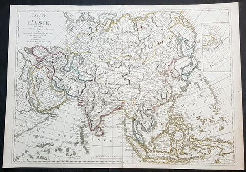
1830 Jean Baptiste Clouet & Pierre Jean Large Antique Map of Asia..Wall Map
- Title : Carte de L Asie, Divisee En Ses Differents Empires et Royaumes Avec...Dressee par J B Nolin...1830
- Ref #: 93437
- Size: 31in x 22in (790mm x 560mm)
- Date : 1780 (1830)
- Condition: (A+) Fine Condition
Description:
This large original hand coloured copper-plate engraved antique map of Asia was engraved and published by Pierre Jean, of the Parisian publishing company Mondhare and Jean in 1830, after the 18th century French cartographer Jean Baptiste Clouet and not Jean Baptiste Nolin jr as noted in the title.
This map is also incredibly rare and I have been unable to find another example sold in the last 25 years.
Since acquiring this large original map, it has been somewhat of an enigma. It is dated 1830 but bears the name of the cartographer J B Nolin, who died in 1790. It was engraved and published by Pierre Jean. But the map bears no cartographical resemblance to any large maps of Asia by Nolin and is also too large to fit into any atlas by Nolin or published by Pierre Jean. This clue finally gave us the answer. The Mondhare and Jean engraving & publishing company were responsible for engraving and printing Jean Baptiste Nolins large world & continental wall maps. And at the same time they were also responsible for the engraving & publishing a series of Wall maps of the world & continents by J B Clouet at the end of the 18th century. These maps are somewhat similar in decoration but are very different in cartographical detail as you can see in the two image comparisons above. This map was published a year after the death of Pierre Jean and we possibly never know it was a mistake or intentional.
General Definitions:
Paper thickness and quality: - Heavy and stable
Paper color : - off white
Age of map color: - Original
Colors used: - Yellow, green, blue, pink
General color appearance: - Authentic
Paper size: - 31in x 22in (790mm x 560mm)
Plate size: - 29 1/2in x 21in (750mm x 535mm)
Margins: - Min 1/2in (12mm)
Imperfections:
Margins: - None
Plate area: - Very small rust hole in Siberia
Verso: - Bottom centerfold rejoined, no loss
Background:
Cartographically the only apparent difference between this map by Jean and the map by Clouet is the updated cartographical data in the inset map of the Bering Straits and the updated information by the surveying by Captain James Cook and others after the 1780s.
Jean Baptiste Clouet 1729 - 1790 Clouet was a French cartographer and geographer born in Rennes, France. He kept premises in both Paris & Cadiz, Spain and was named Royal Geographer of the Academie des Sciences de Rouen in 1785. One of his main works was Géographie Moderne first issued 1767. In 1788 he was responsible for the design of 5 World & Continental wall maps, engraved and printed by the famous Paris publishers Mondhare & Jean.
Jean Baptiste Nolin Jr 1686–1762, son of JB Nolin 1657 - 1708 carried on publishing his fathers stock after his death, contracting the printing to third party publishing companies.
Mondhare & Jean (active 1759 - 1829)
Louis-Joseph Mondhare (1734 - Paris 1799) & Pierre Jean (1754 - 1829) were prominent Parisian publishers, engravers, print and map sellers who were active in Paris in the late 18th and early 19th centuries.
In 1784 Jean married the daughter of Mondhare, who formed a partnership with his son in law, changing forming a very successful partnership thereafter as Mondhare & Jean.
After Mondhare retirement in 1796, Jean carried on with the publishing & printing business, having inherited all of the printing plates that also included many map plates from the likes of Nolin, Clouet, D Anville , Delsile and others. Both Mondhare and Jean were responsible for the engraving and printing of the very decorative large wall maps by J B Nolin & J B L Clouet, as well as single plate maps and atlases. Mondares premises were located at Rue St Jacques, à lHôtel Saumur later moving with Jean to 32 Rue Saint-Jean de Beauvais.
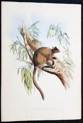
1845-63 John Gould Large Antique Print of Tree Kangaroo The Mammals of Australia
- Title : Dendrolagus Inustus, Mull....H C Richter del et lith....C Hullmandel Imp.
- Ref #: 93442
- Size: 22in x 15in (560mm x 385mm)
- Date : 1845–63
- Condition: (A+) Fine Condition
Description:
This large rare original hand coloured lithograph antique print of The Grizzled Tree Kangaroo, by the artist HC Richter was printed by Charles Joseph Hullmandel 1789 – 1850 in the famous Naturalists John Goulds The Mammals of Australiapublished between 1845–63.
General Definitions:
Paper thickness and quality: - Heavy and stable
Paper color : - off white
Age of map color: - Original
Colors used: - Blue, pink, red, green, yellow
General color appearance: - Authentic
Paper size: - 22in x 15in (560mm x 385mm)
Plate size: - 22in x 15in (560mm x 385mm)
Margins: - Min 1in (25mm)
Imperfections:
Margins: - Light age toning
Plate area: - None
Verso: - None
Background:
The Mammals of Australia is a three-volume work written and published by John Gould between 1845–63. It contains 182 illustrations by the author and its artist H. C. Richter. It was intended to be a complete survey of the novel species of mammals, such as the marsupials, discovered in the colonies of Australia.
The author, John Gould, best known for The Birds of Australia and other major works of ornithology, visited Australia in 1838. In his introduction, Gould says:.....It was not until I arrived in the country, and found myself surrounded by objects as strange as if I had been transported to another planet, that I conceived the idea of devoting a portion of my attention to the mammalian class of its extraordinary fauna......During his short stay he made observations on the natural history and employed his skills as a taxidermist to obtain specimens.
The publication of this major work by Gould followed his A Monograph of the Macropodidae or Family of Kangaroos in 1841. This work was the first comprehensive survey of Australian mammals, and gave an account of their classification and description. Gould also included the indigenous names for the species from the lists he made while in Australia. He used these names to make requests of the local peoples for his specimens, and recorded the regions where the names were used. This conserved a number of common names, such as dibbler (Parantechinus apicalis), which were later recommended by authorities.
The large lithographs reproduced the artwork of Richter, after the drawings and watercolours made in Australia by Gould and his wife, Elizabeth. (The contribution by Elizabeth Gould was uncredited). These were hand-coloured by a group of artists, led by Gabriel Bayfield, that required the completion of 26,572 plates. The illustrations produced during their visit to Australia were supplemented by the preserved specimens returned to England and detailed the characteristics of the species. These illustrations have become iconic images of the mammals of Australia. Among the best known of the illustrations from the work are the two of Thylacinus cynocephalus (Tasmanian tiger), copied since its publication and the most frequently reproduced, made more recognizable by Cascade Brewerys appropriation for its label in 1987. The government of Tasmania published a monochromatic reproduction of the same image in 1934, the author Louisa Anne Meredith also copied it for Tasmanian Friends and Foes (1881).
The Mammals of Australia was published by subscription in the format Imperial Folio; 13 parts in three volumes were issued from 1845 until 1863. To these the author added An Introduction to The Mammals of Australia (1863) in a separate work. This provided corrections and updates, a new preface, introduction, and a list of the mammals of the three volumes. The first two volumes were complete surveys of orders Marsupiata (marsupials), and, with Rodentia in the third, it formed the sum of known mammalian species of Australia. With the addition of those contained in the later Introduction the total of species described reached 166. The same work notes the exclusion of marine mammals such as whales from the volumes, but reprints a manuscript by Charles Coxen on the dugong.
Beyond the scientific value of this comprehensive survey, the document is cited in reference to its subjects conservation. Some of the species included in the work, such as Onychogalea lunata (crescent nailtail wallaby), have since succumbed to changes in land use since European colonisation.
The work was received with acclaim, but the high cost of production, especially of the coloured plates, reduced its accessibility. The original listed price was £41 for the complete set of volumes. The public curiosity for the unique fauna of Australia was met by this handsomely illustrated and comprehensive survey, and it spawned imitations in Australia. The curator of the Australian Museum, Gerard Krefft, produced the more affordable The Mammals of Australia (1871); intended for educational purposes and influenced by Goulds illustrations. Gracius Broinowskis abandoned work, Birds and Mammals of Australia (1884), so closely imitated the plates that an injunction was threatened by its publisher.
Gould, John FRS 1804 – 1881
Gould was an English ornithologist and bird artist. He published a number of monographs on birds, illustrated by plates that he produced with the assistance of his wife, Elizabeth Gould, and several other artists including Edward Lear, Henry Constantine Richter, Joseph Wolf and William Matthew Hart. He has been considered the father of bird study in Australia and the Gould League in Australia is named after him. His identification of the birds now nicknamed Darwins finches played a role in the inception of Darwins theory of evolution by natural selection. Goulds work is referenced in Charles Darwins book, On the Origin of Species.
Gould was born in Lyme Regis the first son of a gardener. He and the boy probably had a scanty education. Shortly afterwards his father obtained a position on an estate near Guildford, Surrey, and then in 1818 Gould became foreman in the Royal Gardens of Windsor. He was for some time under the care of J. T. Aiton, of the Royal Gardens of Windsor. The young Gould started training as a gardener, being employed under his father at Windsor from 1818 to 1824, and he was subsequently a gardener at Ripley Castle in Yorkshire. He became an expert in the art of taxidermy. In 1824 he set himself up in business in London as a taxidermist, and his skill helped him to become the first Curator and Preserver at the museum of the Zoological Society of London in 1827.
Goulds position brought him into contact with the countrys leading naturalists. This meant that he was often the first to see new collections of birds given to the Zoological Society of London. In 1830 a collection of birds arrived from the Himalayas, many not previously described. Gould published these birds in A Century of Birds from the Himalaya Mountains (1830–1832). The text was by Nicholas Aylward Vigors and the illustrations were drawn and lithographed by Goulds wife Elizabeth Coxen Gould. Most of Goulds work were rough sketches on paper from which other artists created the lithographic plates.
This work was followed by four more in the next seven years, including Birds of Europe in five volumes. It was completed in 1837; Gould wrote the text, and his clerk, Edwin Prince, did the editing. The plates were drawn and lithographed by Elizabeth Coxen Gould. A few of the illustrations were made by Edward Lear as part of his Illustrations of the Family of Psittacidae in 1832. Lear, however, was in financial difficulty, and he sold the entire set of lithographs to Gould. The books were published in a very large size, imperial folio, with magnificent coloured plates. Eventually 41 of these volumes were published, with about 3000 plates. They appeared in parts at £3 3s. a number, subscribed for in advance, and in spite of the heavy expense of preparing the plates, Gould succeeded in making his ventures pay, realising a fortune. This was a busy period for Gould who also published Icones Avium in two parts containing 18 leaves of bird studies on 54 cm plates as a supplement to his previous works. No further monographs were published as in 1838 he and his wife moved to Australia to work on the Birds of Australia. Shortly after their return to England, his wife died in 1841. Elizabeth Gould completed 84 plates for Birds of Australia before her death.
When Charles Darwin presented his mammal and bird specimens collected during the second voyage of HMS Beagle to the Zoological Society of London on 4 January 1837, the bird specimens were given to Gould for identification. He set aside his paying work and at the next meeting on 10 January reported that birds from the Galápagos Islands which Darwin had thought were blackbirds, gross-bills and finches were in fact a series of ground Finches which are so peculiar as to form an entirely new group, containing 12 species. This story made the newspapers. In March, Darwin met Gould again, learning that his Galápagos wren was another species of finch and the mockingbirds he had labelled by island were separate species rather than just varieties, with relatives on the South American mainland. Subsequently, Gould advised that the smaller southern Rhea specimen that had been rescued from a Christmas dinner was a separate species which he named Rhea darwinii, whose territory overlapped with the northern rheas. Darwin had not bothered to label his finches by island, but others on the expedition had taken more care. He now sought specimens collected by captain Robert FitzRoy and crewmen. From them he was able to establish that the species were unique to islands, an important step on the inception of his theory of evolution by natural selection. Goulds work on the birds was published between 1838 and 1842 in five numbers as Part 3 of Zoology of the Voyage of H.M.S. Beagle, edited by Charles Darwin. Elizabeth Gould illustrated all the plates for Part 3.
In 1838 the Goulds sailed to Australia, intending to study the birds of that country and be the first to produce a major work on the subject. They took with them the collector John Gilbert. They arrived in Tasmania in September, making the acquaintance of the governor Sir John Franklin and his wife. Gould and Gilbert collected on the island. In February 1839 Gould sailed to Sydney, leaving his pregnant wife with the Franklins. He travelled to his brother-in-laws station at Yarrundi, spending his time searching for bowerbirds in the Liverpool Range. In April he returned to Tasmania for the birth of his son. In May he sailed to Adelaide to meet Charles Sturt, who was preparing to lead an expedition to the Murray River. Gould collected in the Mount Lofty range, the Murray Scrubs and Kangaroo Island, returning again to Hobart in July. He then travelled with his wife to Yarrundi. They returned home to England in May 1840.
The result of the trip was The Birds of Australia (1840–48). It included a total of 600 plates in seven volumes; 328 of the species described were new to science and named by Gould. He also published A Monograph of the Macropodidae, or Family of Kangaroos (1841–1842) and the three volume work The Mammals of Australia (1849–1861).
Elizabeth died in 1841 after the birth of their eighth child, Sarah, and Goulds books subsequently used illustrations by a number of artists, including Henry Constantine Richter, William Matthew Hart and Joseph Wolf.
Throughout his professional life Gould had a strong interest in hummingbirds. He accumulated a collection of 320 species, which he exhibited at the Great Exhibition of 1851. Despite his interest, Gould had never seen a live hummingbird. In May 1857 he travelled to the United States with his second son, Charles. He arrived in New York too early in the season to see hummingbirds in that city, but on 21 May 1857, in Bartrams Gardens in Philadelphia, he finally saw his first live one, a ruby-throated hummingbird. He then continued to Washington D.C. where he saw large numbers in the gardens of the Capitol. Gould attempted to return to England with live specimens, but, as he was not aware of the conditions necessary to keep them, they only lived for two months at most.
Gould published: A Monograph of the Trochilidae or Humming Birds with 360 plates (1849–61); The Mammals of Australia (1845–63), Handbook to the Birds of Australia (1865), The Birds of Asia (1850–83), The Birds of Great Britain (1862–73) and The Birds of New Guinea and the adjacent Papuan Islands (1875–88).
The University of Glasgow, which owns a copy of Birds of Great Britain, describes John Gould as the greatest figure in bird illustration after Audubon, and auctioneers Sotherans describe the work as Goulds pride and joy.
Gould had already published some of the illustrations in Birds of Europe, but Birds of Great Britain represents a development of his aesthetic style in which he adds illustrations of nests and young on a large scale.
Sotherans Co. reports that Gould published the book himself, producing 750 copies, which remain sought after both as complete volumes, and as individual plates, currently varying in price from £450 – £850. The University of Glasgow records that the volumes were issued in London in 25 parts, to make the complete set, between 1863 and 1873, and each set contained 367 coloured lithographs.
Gould undertook an ornithological tour of Scandinavia in 1856, in preparation for the work, taking with him the artist Henry Wolf who drew 57 of the plates from Goulds preparatory sketches. According to The University of Glasgow Goulds skill was in rapidly producing rough sketches from nature (a majority of the sketches were drawn from newly killed specimens) capturing the distinctiveness of each species. Gould then oversaw the process whereby his artists worked his sketches up into the finished drawings, which were made into coloured lithographs by engraver William Hart.
There were problems: the stone engraving of the snowy owl in volume I was dropped and broken at an early stage in the printing. Later issues of this plate show evidence of this damage and consequently the early issue – printed before the accident – are considered more desirable.
The lithographs were hand coloured. In the introduction for the work, Gould states every sky with its varied tints and every feather of each bird were coloured by hand; and when it is considered that nearly two hundred and eighty thousand illustrations in the present work have been so treated, it will most likely cause some astonishment to those who give the subject a thought.
The work has gathered critical acclaim: according to Mullens and Swann, Birds of Great Britain is the most sumptuous and costly of British bird books, whilst Wood describes it as a magnificent work. Isabella Tree writes that it was seen – perhaps partly because its subject was British, as the culmination of [his] ... genius