Recent Acquisitions (34)

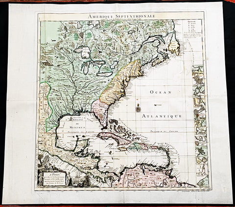
1730 Delisle and Covens & Mortier Foundation Antique Map of North America
- Title : L Amerique Septentrionale dressee sur les Observations de Mrs. De L Academie Royale des Sciences & quelques autres & sur les Memoires les plus recens Par G De L Isle A. Amsterdam Chez I Covens & C Mortier Avec Privilege.
- Ref #: 93501-1
- Size: 25 1/2in x 21 1/2in (650mm x 540mm)
- Date : 1700 (1730)
- Condition: (A+) Fine Condition
Description:
This is without doubt one of the most important foundation maps, of North America, published in the early to mid 18th century. This large original hand coloured copper-plate engraved antique map by Johannes Covens & Pierre Mortier, after Guillaume Delisle, that was published in 1730 in Atlas nouveau de dicerses cartes choisies des Meilleurs Geographes comme Sanson, G De Lisle &c....A Amsterdam.....
The first edition of this map was mistakenly dedicated to Nicolas Sanson, in the title. This oversight was corrected to Delisle in this 1730 edition.
This map is beautiful with original borders beautiful hand colouring on heavy stable paper.
Covens & Mortier (fl 1721-1866) was an eighteenth century cartographic publishing house. The company was founded by Johannes Covens (1697-1774) and Cornelis Mortier (1699-1783) and was located in Vijgendam in Amsterdam .
The collaboration between the two men began after the death of Pieter Mortier (1661-1711), son of a French political refugee. In 1690, Mortier obtained the privilege of distributing maps and atlases from French publishers, in the Netherlands . His widow continued business until his death in 1719 . His son Cornelis took over the business, under the name of his father.
In November 1721 Cornelis Mortier founded a company with Johannes Covens I. He was married in the same year to Corneliss sister. Thus the company of Covens & Mortier was born.
General Definitions:
Paper thickness and quality: - Heavy and stable
Paper color : - off white
Age of map color: - Original & later
Colors used: - Yellow, green, blue, pink
General color appearance: - Authentic
Paper size: - 25 1/2in x 21 1/2in (650mm x 540mm)
Plate size: - 23in x 19in (585mm x 490mm)
Margins: - Min 1in (25mm)
Imperfections:
Margins: - None
Plate area: - None
Verso: - None
Background:
There are many reasons why this rare 1st edition foundation map is important. It contains detail of radical changes both to the interior of North America and helps debunk many fundamentally held ideas of the coastlines. Some of these ideas included The Great lakes, California as an island and previously invented ideas of the interior, NW & NE coastlines.
Specifically the shape of the Great Lakes are changed based on information from the great Italian cartographer Vincenzo Coronelli.
The Mississippi valley is well developed with recent French settlement of d\\\'Iberville at Bilochy and the forts at Bon Secours and St Louis. The map also corrects the error of the western swing of the lower part of the Mississippi River, moving its mouth to essentially its correct position on the Gulf of Mexico.
Delisle has also corrected longitude positions and was the first to revert to a peninsular form for California. He stops his western coast at Cape Mendocin and is the first map to show the Saragossa Sea.
The map also illustrates the routes of explorers such as Cortez, Drake, D\\\'Olivier, Gaeten and Mendana, and indicates the locates of a number of Indian tribes, including the Apaches.
As this is a French map we see many of the French strong points in the NE such as Tadousac, Quebec, Fort Sorel, Montreal & Fort Frontenac included. The English settlements are confined to the east of the Alleghenies, with Fort and River Kinibeki as the border between New England and Arcadia.
Such was the improvement of this map, and the sterling reputation of Delisle, that within a few years other publishers issued their own copies of the map, which continued to appear until the 1780s. The importance of this map cannot be overstated in the progression of American cartography. (Ref: M&B; Tooley)
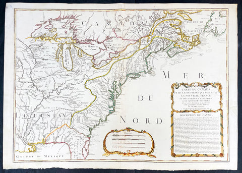
1756 J B Nolin Large Rare Antique Map of North America, Great Lakes, French Indian War (1754-63)
- Title : Carte Du Canada et de La Louisiane Qui Forment La Nouvelle France et Des Colonies Anglois . . . 1756
- Date : 1756 (dated)
- Condition: (A) Very Good Condition
- Ref: 93505
- Size: 30in x 21 1/2in (760mm x 555mm)
Description:
This large, magnificent and very rare original copper plate engraved antique pre-revolutionary French Indian war map of North America was engraved by Jean Baptist Nolin in 1756, dated in cartouche.
This is an important and rare pre-revolutionary French Indian war map, which focuses on the territorial claims of France and Great Britain. Highly detailed showing many early towns and cities, some forts, Indian villages, and tribal territory. Includes the following French text describing the territories claimed by France, Great Britain & Spain in North America: Description du Canada below the cartouche,
This highly detailed map focuses on the territorial claims of France and Great Britain during the French Indian War (1754-63) highly detailed, with a heavy emphasis on the mapping of the Great Lakes. A must for any collector of maps of North America.
We have found records of only 7 sales of this map since 1983, and currently there is only one other to be found for sale.
General Definitions:
Paper thickness and quality: - Heavy and stable
Paper color : - off white
Age of map color: - Original & later
Colors used: - Yellow, green, blue, pink
General color appearance: - Authentic
Paper size: - 30in x 21 1/2in (760mm x 555mm)
Plate size: - 28in x 20 1/2in (720mm x 520mm)
Margins: - Min 1in (25mm)
Imperfections:
Margins: - Small repair to left margin, not affecting the image
Plate area: - Old small repair to top centerfold
Verso: - Re-enforce along centerfold
Background:
The French and Indian War (1754–63) comprised the North American theatre of the worldwide Seven Years War of 1756–63. It pitted the colonies of British America against those of New France. Both sides were supported by military units from their parent countries, as well as by American Indian allies. At the start of the war, the French North American colonies had a population of roughly 60,000 settlers, compared with 2 million in the British North American colonies. The outnumbered French particularly depended on the Indians. The European nations declared war on one another in 1756 following months of localized conflict, escalating the war from a regional affair into an intercontinental conflict.
The name French and Indian War is used mainly in the United States. It refers to the two enemies of the British colonists, the royal French forces and their various American Indian allies. The British colonists were supported at various times by the Iroquois, Catawba, and Cherokee, and the French colonists were supported by Wabanaki Confederacy members Abenaki and Mikmaq, and Algonquin, Lenape, Ojibwa, Ottawa, Shawnee, and Wyandot.
British and other European historians use the term the Seven Years War, as do English-speaking Canadians. French Canadians call it La guerre de la Conquête (the War of the Conquest) or (rarely) the Fourth Intercolonial War.
Fighting took place primarily along the frontiers between New France and the British colonies, from Virginia in the south to Newfoundland in the north. It began with a dispute over control of the confluence of the Allegheny River and Monongahela River called the Forks of the Ohio, and the site of the French Fort Duquesne in Pittsburgh, Pennsylvania. The dispute erupted into violence in the Battle of Jumonville Glen in May 1754, during which Virginia militiamen under the command of 22-year-old George Washington ambushed a French patrol.
In 1755, six colonial governors in North America met with General Edward Braddock, the newly arrived British Army commander, and planned a four-way attack on the French. None succeeded, and the main effort by Braddock proved a disaster; he lost the Battle of the Monongahela on July 9, 1755 and died a few days later. British operations failed in the frontier areas of Pennsylvania and New York during 1755–57 due to a combination of poor management, internal divisions, effective Canadian scouts, French regular forces, and Indian warrior allies. In 1755, the British captured Fort Beauséjour on the border separating Nova Scotia from Acadia, and they ordered the expulsion of the Acadians (1755–64) soon afterwards. Orders for the deportation were given by William Shirley, Commander-in-Chief, North America, without direction from Great Britain. The Acadians were expelled, both those captured in arms and those who had sworn the loyalty oath to His Britannic Majesty. Indians likewise were driven off the land to make way for settlers from New England.
The British colonial government fell in the region of modern Nova Scotia after several disastrous campaigns in 1757, including a failed expedition against Louisbourg and the Siege of Fort William Henry; this last was followed by Indians torturing and massacring their British victims. William Pitt came to power and significantly increased British military resources in the colonies at a time when France was unwilling to risk large convoys to aid the limited forces that they had in New France, preferring to concentrate their forces against Prussia and its allies in the European theater of the war. Between 1758 and 1760, the British military launched a campaign to capture the Colony of Canada (part of New France). They succeeded in capturing territory in surrounding colonies and ultimately the city of Quebec (1759). The British later lost the Battle of Sainte-Foy west of Quebec (1760), but the French ceded Canada in accordance with the Treaty of Paris (1763).
The outcome was one of the most significant developments in a century of Anglo-French conflict. France ceded to Great Britain its territory east of the Mississippi. It ceded French Louisiana west of the Mississippi River (including New Orleans) to its ally Spain in compensation for Spains loss to Britain of Florida. (Spain had ceded Florida to Britain in exchange for the return of Havana, Cuba.) Frances colonial presence north of the Caribbean was reduced to the islands of Saint Pierre and Miquelon, confirming Great Britains position as the dominant colonial power in eastern North America.
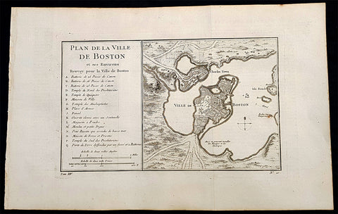
1756 Nicolas Bellin Antique Map of the City of Boston & Charlestown, Harbor
- Title : Plan De La Ville De Boston Et Ses Environs Renvoy pour la Ville de Boston...
- Date : 1756
- Condition: (A+) Fine Condition
- Ref: 93360
- Size: 16in x 10in (405mm x 255mm)
Description:
This original antique map of Boston and surrounding areas - one of the earliest obtainable maps of the city - by Jacques Nicholas Bellin in 1756 - was published in the French edition of Antoine-François Prevosts 20 volume L Histoire Generale des Voyages published by Pierre de Hondt in the Hague between 1747 & 1785.
Beautiful map with great street and building detail in both Boston and Charlestown, showing parts of Ronde Isle and the mainland. Important buildings and areas identified in an idex at the left of the map. Including three cannon batteries, the Presbyterian Church, the Quaker temple, the Anabaptist Church, the City Hall, the Armory, Faneuil Hall (Spelled Fanal), etc. (Ref: Tooley; M&B)
General Definitions:
Paper thickness and quality: - Heavy and stable
Paper color : - off white
Age of map color: -
Colors used: -
General color appearance: -
Paper size: - 16in x 10in (405mm x 255mm)
Plate size: - 11 1/2in x 7 1/2in (285mm x 190mm)
Margins: - Min 1/2in (12mm)
Imperfections:
Margins: - None
Plate area: - Folds as issued
Verso: - None
Background:
Boston is the capital city and most populous municipality of the Commonwealth of Massachusetts in the United States.
Boston is one of the oldest cities in the United States, founded on the Shawmut Peninsula in 1630 by Puritan settlers from England. It was the scene of several key events of the American Revolution, such as the Boston Massacre, the Boston Tea Party, the Battle of Bunker Hill, and the Siege of Boston. Upon U.S. independence from Great Britain, it continued to be an important port and manufacturing hub as well as a center for education and culture.
In the 1820s, Boston\\\'s population grew rapidly, and the city\\\'s ethnic composition changed dramatically with the first wave of European immigrants. Irish immigrants dominated the first wave of newcomers during this period, especially following the Irish Potato Famine; by 1850, about 35,000 Irish lived in Boston. In the latter half of the 19th century, the city saw increasing numbers of Irish, Germans, Lebanese, Syrians, French Canadians, and Russian and Polish Jews settling in the city. By the end of the 19th century, Boston\\\'s core neighborhoods had become enclaves of ethnically distinct immigrants. Italians inhabited the North End, Irish dominated South Boston and Charlestown, and Russian Jews lived in the West End. Irish and Italian immigrants brought with them Roman Catholicism. Currently, Catholics make up Boston\\\'s largest religious community and the Irish have played a major role in Boston politics since the early 20th century; prominent figures include the Kennedys, Tip O\\\'Neill, and John F. Fitzgerald.
Between 1631 and 1890, the city tripled its area through land reclamation by filling in marshes, mud flats, and gaps between wharves along the waterfront. The largest reclamation efforts took place during the 19th century; beginning in 1807, the crown of Beacon Hill was used to fill in a 50-acre mill pond that later became the Haymarket Square area. The present-day State House sits atop this lowered Beacon Hill. Reclamation projects in the middle of the century created significant parts of the South End, the West End, the Financial District, and Chinatown.
After the Great Boston Fire of 1872, workers used building rubble as landfill along the downtown waterfront. During the mid- to-late 19th century, workers filled almost 600 acres of brackish Charles River marshlands west of Boston Common with gravel brought by rail from the hills of Needham Heights. The city annexed the adjacent towns of South Boston (1804), East Boston (1836), Roxbury (1868), Dorchester (including present day Mattapan and a portion of South Boston) (1870), Brighton (including present day Allston) (1874), West Roxbury (including present day Jamaica Plain and Roslindale) (1874), Charlestown (1874), and Hyde Park (1912). Other proposals were unsuccessful for the annexation of Brookline, Cambridge and Chelsea.
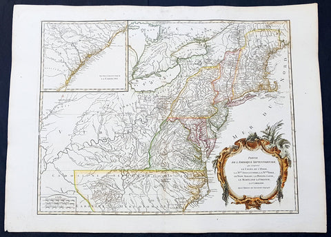
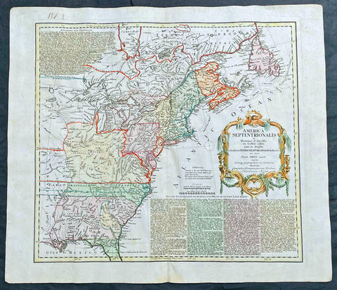
1768 Robert De Vaugondy Large Antique 2nd edition Map of Colonial United States
- Title : Partie De L Amerique Septentrionale, qui Comprend Le Cours De L Ohio...Par le Sr Robert de Vaugondy
- Date : 1768
- Condition: (A+) Fine Condition
- Ref: 93129
- Size: 30in x 22in (760mm x 560mm)
Description:
This large original beautifully hand coloured, scarce 2nd edition antique map of the east coast of the United States, illustrating the course of the Ohio River and stretching from New England to the Carolinas, north to the Great Lakes and south to the Mississippi - with an inset map of The Carolinas - was published in 1768 by Robert Du Vaugondy in his Atlas Universal.
This is one of the best examples of this map I have seen, beautiful hand colour on age toned heavy paper with original margins with a heavy dark ink denoting an early pressing.
General Definitions:
Paper thickness and quality: - Heavy and stable
Paper color : - off white
Age of map color: - Original & later
Colors used: - Yellow, green, blue, pink
General color appearance: - Authentic
Paper size: - 30in x 22in (760mm x 560mm)
Plate size: - 25in x 19 1/2in (635mm x 495mm)
Margins: - Min 1in (25mm)
Imperfections:
Margins: - Light spotting in top margin
Plate area: - None
Verso: - None
Background:
Second state of the early de Vaugondy map of the British colonies, with changes after the 1763 Treaty of Paris, with Virginia & Carolina extended to the Mississippi and Pennsylvania extended to Lake Erie. The majority of geographical information is based upon John Mitchells great map of North America from the mid 1750s, also drawing from Lewis, Evans on the Middle British Colonies and Joshua Frys and Peter Jeffersons map of Virginia and Maryland. The Mitchell map was the culmination of many years of British surveying in the North American Colonies and was considered one of the best maps of the continent available to Europeans and Americans in the mid-eighteenth century.
De Vaugondys rendition does not copy the full scope of Mitchells map but instead focuses on the colonies stretching from southern Maine to the Carolinas. In the top left corner is an inset of South Carolina and Georgia. De Vaugondy also pays special attention to the river systems and settlements. This map shows some of the earliest accurate information of the trans-Allegheny regions (the Ohio River, Kentucky, Tennessee and Parts of Ohio) and inland areas to the southeast of the Great Lakes and interior of New England.
Maine is still part of the Massachusetts Bay Colony. During this era. The dispute between New Hampshire and New York over who controlled the area which is now Vermont has been resolved. The outbreak of the French & Indian War (Seven Years War) briefly suspended interest in the disputed area, and it was not until 1764 that the British crown upheld New Yorks claim to Vermont. Included is a beautiful title cartouche in the Rococo style. (Ref: Tooley; M&B)
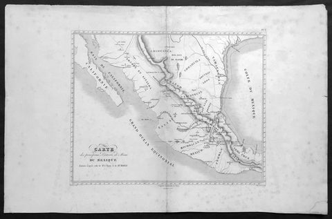
1843 Baron Von Humboldt Large Old, Antique Map of Texas & Mexico, Mining - Rare
- Title : Carte des principaux Districts de Mines Du Mexique Reduite d apres celle de Mr. le Baron A de Humbold
- Ref #: 61108
- Size: 22in x 14in (560mm x 360mm)
- Date : 1843
- Condition: (A+) Fine Condition
Description:
This large, scarce original, antique map* showing the location of Mines in Texas and Mexico in the early part of the 19th century by Baron Humboldt was engraved by Dutos in 1843. This map is scarce with no other example available currently on the market.
Friedrich Wilhelm Heinrich Alexander von Humboldt (14 September 1769 – 6 May 1859) was a Prussian geographer, naturalist, explorer, and influential proponent of Romantic philosophy and science. He was the younger brother of the Prussian minister, philosopher, and linguist Wilhelm von Humboldt (1767–1835). Humboldt's quantitative work on botanical geography laid the foundation for the field of biogeography. Humboldt's advocacy of long-term systematic geophysical measurement laid the foundation for modern geomagnetic and meteorological monitoring.
Between 1799 and 1804, Humboldt travelled extensively in Latin America, exploring and describing it for the first time from a modern scientific point of view. His description of the journey was written up and published in an enormous set of volumes over 21 years. Humboldt was one of the first people to propose that the lands bordering the Atlantic Ocean were once joined (South America and Africa in particular). Humboldt resurrected the use of the word cosmos from the ancient Greek and assigned it to his multi-volume treatise, Kosmos, in which he sought to unify diverse branches of scientific knowledge and culture. This important work also motivated a holistic perception of the universe as one interacting entity. (Ref: M&B; Tooley)
General Description:
Paper thickness and quality: - Light & stable
Paper color: - White
Age of map color: -
Colors used: -
General color appearance: -
Paper size: - 22in x 14in (560mm x 360mm)
Paper size: - 15in x 13in (390mm x 330mm)
Margins: - Min 2in (50mm)
Imperfections:
Margins: - Age toning, light spotting
Plate area: - Light uplift along centerfold
Verso: - Age toning, light spotting

1744 Bellin & de Maurepas Large Antique Map North America Colonial United States
- Title : Carte De La Louisiane Cours Du Mississipi et Pais Voisins...N Bellin 1744
- Date : 1744
- Size: 23in x 16 1/4in (585mm x 415mm)
- Condition: (A) Very Good Condition
- Ref: 27094
Description:
This important, original hand coloured copper plate engraved antique map of North America and the colonial states by Nicolas Bellin in conjunction with Jean-Frédéric Phélypeaux, the Comte de Maurepas, was engraved and published in 1744, dated.
This detailed map depicts the region of Louisiana and the Mississippi River, as well as neighboring territories such as Florida, the Great Lakes, and the Gulf of Mexico. The map is richly decorated with a detailed cartouche featuring a Native American figure, various animals, and a scale bar.
The map is highly detailed and accurate, with the major waterways, coastlines, and settlements clearly marked. The topographical features such as mountains, forests, and swamps are also depicted in great detail. The map includes annotations in French, indicating the locations of various Native American tribes and European settlements.
One interesting feature of the map is the depiction of the river system, with numerous tributaries branching out from the Mississippi River. The map also includes illustrations of the mouth of the Mississippi River and various settlements along its banks.
Overall, Carte De La Louisiane Cours Du Mississipi et Pais Voisins is a beautiful and informative example of 18th-century cartography. Bellin's map reflects the geopolitical tensions of the era, as France and England were competing for control over the region, and it remains a valuable resource for historians and collectors alike.
General Definitions:
Paper thickness and quality: - Heavy and stable
Paper color : - off white
Age of map color: - Original
Colors used: - Yellow, green, blue, pink
General color appearance: - Authentic
Paper size: - 23in x 16 1/4in (585mm x 415mm)
Plate size: - 23in x 16 1/4in (585mm x 415mm)
Margins: - Min 1/2in (12mm)
Imperfections:
Margins: - Right margin extended from border
Plate area: - Folds as issued
Verso: - Folds as issued
Background:
The Comte de Maurepas and Nicolas Bellin were both influential figures in the French Navy during the 18th century, and they worked closely together on several important projects.
Jean-Frédéric Phélypeaux, the Comte de Maurepas, was a French statesman who served as Secretary of State for the Navy under Louis XV. He was a strong supporter of naval exploration and cartography, and he played a key role in promoting the work of cartographers such as Nicolas Bellin.
Nicolas Bellin, as mentioned earlier, was a French cartographer, hydrographer, and engineer who produced numerous maps and atlases that were highly regarded for their accuracy and detail. Bellin worked closely with the Comte de Maurepas on several projects, including the creation of the Neptune François, a collection of maps and nautical charts of the world's oceans.
The Neptune François was a major undertaking that involved the collaboration of numerous cartographers and hydrographers, including Bellin. The project was overseen by the Comte de Maurepas and was intended to provide French sailors with the most up-to-date and accurate information about the world's oceans.
Bellin's contributions to the Neptune François were extensive, and he was responsible for creating numerous maps and charts that covered a wide range of regions, including the Mediterranean, the Caribbean, and North America. His work on the project helped establish him as one of the leading cartographers of his time.
Overall, the Comte de Maurepas and Nicolas Bellin were both instrumental in advancing the field of cartography during the 18th century. Through their collaboration on projects such as the Neptune François, they helped to establish the French Navy as a leading authority on maritime exploration and mapping.
Please note all items auctioned are genuine, we do not sell reproductions. A Certificate of Authenticity (COA) can be issued on request.
1742 Henry Popple & George Le Rouge Large Antique Map of Colonial America
- Title : Amerique Septentrionale Suivant la Carte de Pople....A Paris....Le Rouge...1742
- Date : 16742
- Size: 24 1/2in x 22 1/2in (625mm x 570mm)
- Condition: (A) Very Good Condition
- Ref: 27093
Description:
This incredibly important, original hand coloured copper plate engraved antique map of North America by George Le Rouge, after Henry Popples famous North America map, was published in 1742 - dated.
A handsome key sheet from a French edition of the first large-scale map of colonial North America. Among the 18 inset maps along the right border are ones of Bermuda, Boston, New York City, and Charleston. Popple's original, 1733 map ran to 20 sheets, hence the necessity of a key sheet. It was a semi-official undertaking intended to depict for British colonial administrators the respective North American territories of England, France and Spain. This French-published version, as expected, greatly exaggerates French territory at the expense of both England and Spain.
General Definitions:
Paper thickness and quality: - Heavy and stable
Paper color : - off white
Age of map color: - Original & later
Colors used: - Yellow, green, blue, pink
General color appearance: - Authentic
Paper size: - 24 1/2in x 22 1/2in (625mm x 570mm)
Plate size: - 20 3/4in x 19 3/4in (525mm x 500mm)
Margins: - Min 1in (30mm)
Imperfections:
Margins: - Light creasing along margins
Plate area: - Light creasing
Verso: - Re-enforced along centerfold
Background:
In 1730, the English Board of Trade & Plantations issued a request for maps of the British, French, and Spanish territorial claims in the New World, as ongoing boundary conflicts hindered economic development in the colonies. A former employee, Henry Popple, created an incredible 20-sheet map first published in 1733 that covered a broad region between Hudson Bay and the northern coast of South America and inland as far as the Rio Grande. It would become tremendously influential diplomatically as disputes among European powers increased dramatically in subsequent decades.
Accompanying the monumental production was a keymap, seen here as a later French edition issued by Georges Louis Le Rouge in 1742. With the exception of the language, decorative elements, annotations, and a missing vignette in the upper left corner, the image is largely the same as the original. It’s surprisingly accurate, as Popple was studious in his use of the latest available sources, though several geographic features have been enlarged or distorted and a large mysterious lake filled with islands appears near the western edge of the sheet.
It’s likely this is a remnant of the great saline sea speculated by Baron Lahontan, a French military officer who traveled extensively throughout the Great Lakes region from 1684 -1689. He later wrote several popular travel volumes that included reports of a Long (or Longue) River that branched from the Missippi westward, eventually reaching a large salt lake at the foot of a mountain range. The geographic influences of his story would be reflected in subsequent cartographic efforts throughout the 18th and into the early 19th century, and speculation on Lahontan’s travels persists to this day.
Elsewhere in the image, the topography is depicted pictorially and shows a prominent Appalachian Mountain range as well as a curious plateau in Michigan that Lewis Karpinski describes as a “fanciful creation.” Native American and European settlements are identified throughout and geographic features are labeled according to the key in the upper right. Seventeen inset plans of prominent port cities and islands can be seen in the lower right; including Boston, Charleston, New York, St. Augustine, Havana, and Cartagena.
Popple, Henry 1680 - 1743
Henry Popple was a British cartographer active in the early part of the 18th century. Popple was a clerk with the Board of Trade and Plantations, the organization that governed Britain's colonies in America. With his father, grandfather, and brother all being employed the board of trade, the Popple family had a long history of association with the British colonial administration. Popple received his commission as a clerk at the board of trade in 1727, but resigned in the same year. Curiously this is the same year he began work on his signature production, the Popple of North America, he resigned from the board to take a position as the Cashier to Queen Anne. Nonetheless he continued to work on his great maps and a manuscript version of the Popple Map appeared in this very year. Subsequently, Popple continued to update and refine the map until 1733 when it was finally printed. The Board of trade intended the Popple map to be a British response to Delisle's French mapping of North America, which presented boundaries that conflicted with British colonial ambitions. However, since Popple in fact based much of his map on Delisle's superior cartography, he also managed to copy many of the French political boundaries - to the detriment of the Board of Trade and its expansionist intentions. Although Popple's map was never approved by the Board, examples were rushed to each colonial governor and the map played a significant role in the cartographic history of North America. Popple cartographic endeavor began and ended with this singular map however, it significance was such that he must be considered in any list of significant British mapmakers.
George Louis Le Rouge fl. 1740-80
A military engineer by profession, le Rouge took up cartography and over a long period from about 1740 to 1780 produced many attractive works covering a wide range of subjects including plans of fortifications, military campaigns, town plans as well as the more usual atlases and sea charts.

1879 Lorenz Large Antique Map Coal Seams Schuylkill County, Pennsylvania Reading
- Title : Map Showing Coal Laterals of the Philadelphia & Reading Rail Raod company William Lorenz Chief Eng. 1879
- Date : 1879
- Size: 29in x 19 1/2in (735mm x 495mm)
- Condition: (A) Very Good Condition
- Ref: 93520
Description:
This original, large folding rare lithograph map of the Coal Fields of Schuylkill County, Pennsylvania, owned at the time by the Pennsylvania & Reading Railroad Company by William Lorenz was engraved and published in 1879 - dated.
The Definition of a Coalseam lateral is any system of development in coal seams or thick orebodies in which headings are driven horizontally across the coal or ore and connected to main haulage drifts, entries, or shafts. There are many variations and modifications depending on the thickness, shape, and inclination of the deposit.(Ref Tooley M&B)
General Definitions:
Paper thickness and quality: - Heavy and stable
Paper color : - off white
Age of map color: - Original
Colors used: - Pink, blue
General color appearance: - Authentic
Paper size: - 29in x 19 1/2in (735mm x 495mm)
Plate size: - 29in x 19 1/2in (735mm x 495mm)
Margins: - Min 1/2in (12mm)
Imperfections:
Margins: - Chipping to map edges not affecting the image
Plate area: - Light wear along sectioned edges
Verso: - Backed in linen
Background:
Schuylkill is a county in the Commonwealth of Pennsylvania. It is located in the heart of Pennsylvanias Coal Region and is part of Northeastern Pennsylvania. As of the 2020 census, the population was 143,049. The county seat is Pottsville.
The county was created on March 1, 1811, from parts of Berks and Northampton counties and named for the Schuylkill River, which originates in the county. On March 3, 1818, additional territory in its northeast was added from Columbia and Luzerne counties. The county is part of the Pottsville, Pennsylvania Micropolitan Statistical Area.
The lands that today constitute Schuylkill County were acquired by William Penns proprietors by treaty executed August 22, 1749, with representatives of the Six Nations and the Delaware, Shamokin and Shawnee, who received 500 pounds lawful money of Pennsylvania. The territory described included all of Schuylkill County except the northern part of Union Township, which was included in the purchase of 1768.
In the year 1754, the area that would become Schuylkill County along with the areas that today are Berks, Dauphin, Lebanon, and Lehigh counties were settled by German immigrants. The earliest settlers in southeastern Schuylkill County, which was then part of Northampton County, were primarily Moravian missionaries from Saxony. Other early settlers in southern Schuylkill County were German Palatines.
An early mill in the county was built in 1744 by John Finscher, but it later burned down. The first log church in the county was built in 1755. Native American massacres were commonplace in Schuylkill County between 1755 and 1765. Warrant for tracts of land in the vicinity of McKeansburg were in existence as early as 1750. Found by Sammy Hepler in 1789.
Anthracite coal (then called stone coal) was discovered by Necho Allen near the area where Pottsville was ultimately developed in 1790. In 1795, a blacksmith in Schuylkill County named Whetstone learned how to use the coal successfully for smithing purposes. In 1806 coal was found while the tail-race was cut of the Valley (Iron) Forge, on the Schuylkill. Daniel Berlin, another blacksmith, also used it successfully, and smiths in the neighborhood adopted using the coal.
Schuylkill County was created via an Act of Assembly on March 1, 1811, from portions of Berks and Northampton counties. More land was added to the county in 1818, from Columbia and Luzerne counties. At the time of its creation, the county had a population of about 6,000. An early book of Schuylkill County history was written by Daniel Deibert in 1802.
Orwisgsburg was the first community in Schuylkill County to be laid out. During the early years of Schuylkill County, there was an attempt to make McKeansburg the county seat; Orwigsburg was also a contender. Orwigsburg was agreed upon to be the county seat, as it was deemed to be well-suited for industries. Beginning in 1831, sentiment began to rise for moving the county seat to Pottsville. In 1846, the Legislature passed an Act that was approved by Governor Francis R. Shunk on March 13, submitting the question to the voters. The change was desired principally because the railroad and canal connections with Orwigsburg were problematic to transport the public to that town without losing valuable time while Pottsville had such facilities and was within easy access from all parts of the county.
In 1812, George Shoemaker who, with Necho Allen, had discovered stone coal at Centerville in Schuylkill County, personally delivered some coal to Philadelphia. He gave away most of the coal, intending to encourage individuals to find ways to use it. Most of the experiments failed and though Shoemaker was nearly run out of town and called an imposter, Mellon and Bishop of Delaware County successfully used it in their rolling mill. When other rolling mills also adopted the fuel, a large industrial market and demand developed.
The Schuylkill Navigation Company was chartered in 1815 to build a series of navigation improvements in the Schuylkill River. This was during a period when the much larger Erie Canal along the Mohawk River in New York also was being developed. It was well ahead of other key canals fueling the Industrial Revolution, such as the Delaware and Hudson, the Lehigh, the Chesapeake and Ohio, Delaware and Raritan, and Morris canals. The originators of the project did not count upon the coal trade to promote the success of the undertaking. They looked forward mainly to transporting the agricultural products being produced below the mountains, the lumber of Schuylkill County, and the grain and other products of the counties between the Susquehanna and Schuylkill rivers. The first shipments of coal by canal were made in 1822 when 1,480 tons were sent down the line.
With a regular supply of anthracite coal ensured, the southern anthracite coal field in Schuylkill County attracted speculators and fortune hunters. They were inspired by dreams of becoming millionaires. This was the first speculative era of the Schuylkill coal trade. Pottsville became the center of the movement. The more successful explorers revealed numerous veins of coal, extending over a vast stretch of county and with a seemingly inexhaustible quantity of coal. These discoveries brought excitement and speculation; lands were bought (and sold); roads were laid out in the forest, mines were opened and railroads projected, and innumerable town plots planned. The demand for houses was so great that the lumber for many was framed in Philadelphia and sent by canal to the burgeoning coal region.
At this stage, coal-mining firms were small and family owned. The residents and entrepreneurs of the Schuylkill region opposed the entry here of incorporated coal companies. In these years, coal mining operations in the Schuylkill region were conducted with economy, and relatively little capital was required. As the workings were all above the water level, no machinery was required for water drainage or for hoisting coal to the surface. Coal breakers and other expensive fixtures and appliances for the preparation of coal had not then been introduced. Numerous operators produced from five to six thousand tons for market annually (which was then considered a respectable business), who had never committed thousands of dollars to their enterprises, including their first land purchases of coal mines. It was commonly asserted that coal land could be bought and mines opened for less capital than the purchase and stocking of a decent farm. Such mines could be worked for less capital than that required to establish a line of stagecoaches or transportation wagons.
Eventually, railroads replaced the canals as the primary means of transporting coal to markets. Mining was taken over by major corporate business, especially after the Civil War. As a result, the Middle Coal Field was developed in the 1860s and the Philadelphia and Reading Railroad created a subsidiary (Philadelphia and Reading Coal and Iron Company) to buy or lease, and develop the expanding industrial coal trade. Consumption of coal along the Schuylkill above Philadelphia in 1839 was 30,290 tons when the Pioneer at Pottsville, the first anthracite furnace in the United States, became operational. By 1849, consumption had increased to 239,290 tons, to 554,774 tons in 1859, and to 1,787,205 tons in 1873.
The numerous jobs in the mining industry comprised a catalyst for mass immigration to Schuylkill County from the British Isles and Europe in the 19th and 20th centuries. As mines became more numerous (by 1846 there were 110 operators in the region and 142 collieries in Schuylkill County) and more complex (in 1846 there were 35 collieries below water level), mechanical breakers, steam locomotive, it became more labor-intensive both for accomplishing mining tasks and supporting minings peripheral industries. Such industries included manufacturing of explosives, metal screens, pump components, piping, and timber for support. This led to an influx of population into Schuylkill and other anthracite counties to fill these jobs. Beginning with the Irish immigration in the 1840s (fueled by the Great Famine), after the Civil War, beginning in the 1870s, newcomers arrived from Eastern Europe. Poles, Hungarians, Lithuanians, Slovaks, Rusyns and Ukrainians (Ruthenians), often from the Austro-Hungarian monarchy settled in the villages of Schuylkill County and took their place among the laborers in the coal mines. By the 1880s and 1890s, thousands of Italians immigrated for jobs related to mining.
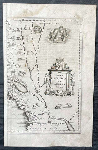
1635 Joan Blaeu Antique Half Page Map of New England, Nova Belgica et Anglia
- Title : Nova Belgica Et Anglia Nova
- Date : 1635
- Size: 18 1/2in x 12in (470mm x 305mm)
- Condition: (A) Good Condition
- Ref: 16385
Description:
This original copper-plate engraved antique half right hand page map of New England & NE America by Joan Blaeu was published in the 1635 German edition of Atlas Novus.
This is the right hand, cartouche title section of this important map.
General Definitions:
Paper thickness and quality: - Heavy and stable
Paper color : - off white
Age of map color: -
Colors used: -
General color appearance: -
Paper size: - 18 1/2in x 12in (470mm x 305mm)
Plate size: - 15 1/2in x 10in (395mm x 255mm)
Margins: - Min 1/2in (12mm)
Imperfections:
Margins: - Soiling, small worm hole top right margin
Plate area: - Light soiling, 4 small worm holes
Verso: - Light soiling
Background:
This important map was one of the most attractive of the Americas published at the time. It is noted for the fact that its primary source is the first manuscript figurative map of Adriaen Block from 1614. Indeed it is the first full representation of it in print. It is one of the earliest to name Nieu Amsterdam. Block, a Dutch fur trader, explored the area between Cape Cod and Manhattan, examining the bays and rivers along the way. This helped to create an accurate picture of the longitudinal scale of the coastline. His manuscript map is the first document to delineate an insular Manhattan; it also provides the earliest appearance of Manhates and Niev Nederland.
It has been noted that the time difference between 1614, the date of the manuscript, and Blaeus map whose first appearance is in 1635, appears long for such an important advance. It would seem highly feasible that Blaeu, who published many separately issued maps, would have wanted to produce one like this sooner. However, evidence points to the fact that it could not have been made before 1630. The Stokes Collection in New York possesses an example of the map on thicker paper without text on the reverse which could well be a proof issue of some kind.
There are features on Blaeus map that differ from the Block chart. Some of these could be accounted for by the fact that the surviving figurative map is not the original, and that the copyist omitted some place names that are referred to in the text of de Laets work. Block drew on Champlains map of 1612 for the depiction of the lake named after him, but it is here called Lacus Irocoisiensis. … The lack of interrelation between the Dutch or English colonies and the French, led for some time to the eastward displacement of this lake when its true position would be north of the Hudson River.
Some nomenclature has its origins in Blaeus second Paskaert of c.1630, and others, such as Manatthans, in de Laet. The colony of Nieu Pleimonth is identified. This and other English names along that part of the coast are largely derived from Smith\\\'s New England, 1616. Cape Cod is here improved over the Block manuscript by being reconnected to the mainland, the narrow strait having been removed. The coastline between here and Narragansett Bay, which can be clearly recognized, is not so accurate. Adriaen Blocx Eylandt leads us to the Versche Rivier, or Connecticut River, which Block ascended as far as was possible. t Lange Eyland is named; however, it is incorrectly too far east, being applied to what is possibly Fishers Island. De Groote bay marks Long Island Sound. The Hudson River is still not named as such, but is littered with Dutch settlements, and the failed Fort Nassau is here depicted renamed as Fort Orange. He does, however, improve on the direction of its flow. Blaeu separates the sources of the Hudson and Delaware Rivers which had been causing some confusion. Nieu Amsterdam is correctly marked as a fort at the tip of an island separated on the east side by Hellegat, or the East River. The coastline south of Sandy Hook also shows signs of improvement.
The whole map is adorned by deer, foxes, bears, egrets, rabbits, cranes and turkeys. Beavers, polecats and otters appear on a printed map for the first time. The Mohawk Indian village top right is derived from the de Bry-White engravings.
1756 Homann Antique Map Colonial United States North America French Indian War
- Title : America Septentrionalis a domino d Anville in Galiis edita nunc in Anglia coloniis in interiorem Virginiam deductis nec non fluvii Ohio cursu aucta notisq geographicis et historicis illustrata.....1756
- Ref #: 27018
- Size: 24in x 21in (610mm x 535mm)
- Date : 1756
- Condition: (A) Very Good Condition
Description:
This original hand coloured copper-plate engraved antique 1st edition map of the Colonial United States, at the beginning of the French-Indian war, was engraved in 1756 - dated in cartouche - by the Homann firm, Germany.
This map has original margins and colour on heavy clean sturdy paper.
First edition Homann map of the English Colonies in North America prior to the start of the French and Indian War. The map stretches just west of the Mississippi River to the east and from James Bay through the Great Lakes to the Gulf of Mexico. Although most of the text is in German, there is also much in English, including numerous place named annotations associated the French and Indian War, such as the locations of Fort Duquesne and Fort Necessity, both taken by the French in 1754. Thus although the cartographer credits D Anville for the basic cartography, it is clear he is drawing from English, not French, sources. Bottom right and upper left are notes offering the history of North America.
General Definitions:
Paper thickness and quality: - Heavy and stable
Paper color : - off white
Age of map color: - Original & later
Colors used: - Yellow, green, blue, pink
General color appearance: - Authentic
Paper size: - 24in x 21in (610mm x 535mm)
Plate size: - 21in x 19in (535mm x 480mm)
Margins: - Min 1/2in (12mm)
Imperfections:
Margins: - Light staining in lower margins, bottom margin centerfold rejoined with transparent archival tape
Plate area: - Light age toning along centerfold
Verso: - None
Background:
The French and Indian War (1754–63) comprised the North American theatre of the worldwide Seven Years War of 1756–63. It pitted the colonies of British America against those of New France. Both sides were supported by military units from their parent countries, as well as by American Indian allies. At the start of the war, the French North American colonies had a population of roughly 60,000 settlers, compared with 2 million in the British North American colonies. The outnumbered French particularly depended on the Indians. The European nations declared war on one another in 1756 following months of localized conflict, escalating the war from a regional affair into an intercontinental conflict.
The name French and Indian War is used mainly in the United States. It refers to the two enemies of the British colonists, the royal French forces and their various American Indian allies. The British colonists were supported at various times by the Iroquois, Catawba, and Cherokee, and the French colonists were supported by Wabanaki Confederacy members Abenaki and Mikmaq, and Algonquin, Lenape, Ojibwa, Ottawa, Shawnee, and Wyandot.
British and other European historians use the term the Seven Years War, as do English-speaking Canadians. French Canadians call it La guerre de la Conquête (the War of the Conquest) or (rarely) the Fourth Intercolonial War.
Fighting took place primarily along the frontiers between New France and the British colonies, from Virginia in the south to Newfoundland in the north. It began with a dispute over control of the confluence of the Allegheny River and Monongahela River called the Forks of the Ohio, and the site of the French Fort Duquesne in Pittsburgh, Pennsylvania. The dispute erupted into violence in the Battle of Jumonville Glen in May 1754, during which Virginia militiamen under the command of 22-year-old George Washington ambushed a French patrol.
In 1755, six colonial governors in North America met with General Edward Braddock, the newly arrived British Army commander, and planned a four-way attack on the French. None succeeded, and the main effort by Braddock proved a disaster; he lost the Battle of the Monongahela on July 9, 1755 and died a few days later. British operations failed in the frontier areas of Pennsylvania and New York during 1755–57 due to a combination of poor management, internal divisions, effective Canadian scouts, French regular forces, and Indian warrior allies. In 1755, the British captured Fort Beauséjour on the border separating Nova Scotia from Acadia, and they ordered the expulsion of the Acadians (1755–64) soon afterwards. Orders for the deportation were given by William Shirley, Commander-in-Chief, North America, without direction from Great Britain. The Acadians were expelled, both those captured in arms and those who had sworn the loyalty oath to His Britannic Majesty. Indians likewise were driven off the land to make way for settlers from New England.
The British colonial government fell in the region of modern Nova Scotia after several disastrous campaigns in 1757, including a failed expedition against Louisbourg and the Siege of Fort William Henry; this last was followed by Indians torturing and massacring their British victims. William Pitt came to power and significantly increased British military resources in the colonies at a time when France was unwilling to risk large convoys to aid the limited forces that they had in New France, preferring to concentrate their forces against Prussia and its allies in the European theater of the war. Between 1758 and 1760, the British military launched a campaign to capture the Colony of Canada (part of New France). They succeeded in capturing territory in surrounding colonies and ultimately the city of Quebec (1759). The British later lost the Battle of Sainte-Foy west of Quebec (1760), but the French ceded Canada in accordance with the Treaty of Paris (1763).
The outcome was one of the most significant developments in a century of Anglo-French conflict. France ceded to Great Britain its territory east of the Mississippi. It ceded French Louisiana west of the Mississippi River (including New Orleans) to its ally Spain in compensation for Spains loss to Britain of Florida. (Spain had ceded Florida to Britain in exchange for the return of Havana, Cuba.) Frances colonial presence north of the Caribbean was reduced to the islands of Saint Pierre and Miquelon, confirming Great Britains position as the dominant colonial power in eastern North America.
Please note all items auctioned are genuine, we do not sell reproductions. A Certificate of Authenticity (COA) can be issued on request.
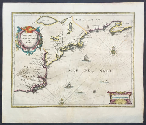
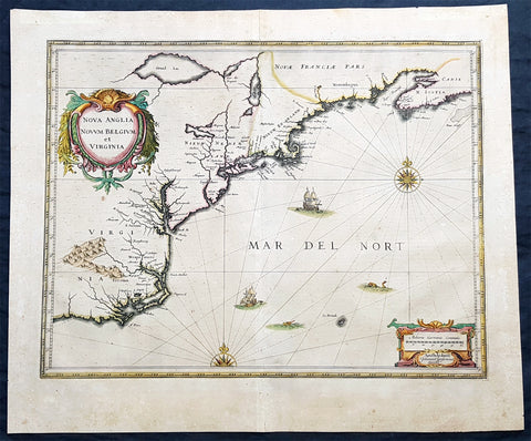
1639 Jan Jansson Antique Map of North America Virginia to New York to New England
- Title : Nova Anglia Novvm Belgium et Virginia
- Date : 1639
- Condition: (A+) Fine Good Condition
- Ref: 43134
- Size: 22 1/2in x 19 1/2in (570mm x 495mm)
Description:
This beautifully hand coloured, important original antique map of the north east regions of the United States from Virginia, Chesapeake Bay, to New York & New England by Jan Jansson was published in the 1639 French edition of the Jansson, Hondius Atlas.
A beautiful map with sturdy, clean paper original wide margins and beautiful original hand colouring.
General Definitions:
Paper thickness and quality: - Heavy and stable
Paper color : - off white
Age of map color: - Original
Colors used: - Blue, pink, red, green, yellow
General color appearance: - Authentic
Paper size: - 22 1/2in x 19 1/2in (570mm x 495mm)
Plate size: - 20in x 15 1/2in (535mm x 395mm)
Margins: - Min 1in (25mm)
Imperfections:
Margins: - Light toning on margin edges
Plate area: - Very light offsetting
Verso: - None
Background:
A beautiful original 17th map of Virginia, New York and New England which was derived from the less well circulated Johannes de Laet map of 1630. This version is enlarged and expanded to the north and slightly east, with de Laets narrative on the verso (De Laets map is one of extreme importance, being the first printed to use the namesManbattes (Manhattan) and N. Amsterdam)
The nomenclature on this map is virtually identical to the De Laet map, with the few minor differences most likely owing to the engravers error. C of Feare is still depicted over 2° too far south. This is not Cape Fear we know of today but actually Cape lookout.
During the fiercely competitive decade of the 1630's the families of Blaeu and Jansson produced maps drawn directly from one another. Here, however, Jansson produces one that was not followed by Blaeu, relying upon the more restricted map of Nova Belgica to represent the land north of Chesapeake Bay. A sign of the Dutch influence here is that both atlas producers largely declined to include the advanced cartography of Champlain, thereby relegating it altogether.
There are three know states of this map, the first one published in 1636 - entitled Nova Anglia Novvm Belgium et Virginia.
The second edition in which the title of the map was changed to Nova Belgium et Anglia Nova (to give more weight to Dutch claims in North America) within a new square cartouche was first published in 1647.
State 3 was published in 1694 by Schenk & Valk which included new regional demarcation and a latitude and longitude grid. (Ref: Koeman; M&B; Tooley; Burden; AMPR)
1639 Jan Jansson Antique Map of North America Virginia to New York to New England
- Title : Nova Anglia Novvm Belgium et Virginia
- Date : 1639
- Condition: (A) Very Good Condition
- Ref: 93508
- Size: 23in x 19in (585mm x 485mm)
Description:
This magnificent original copper plate engraved antique landmark 1st edition map of the NE region of North America, the original colonial states from Virginia to New England, was published in the 1639 French edition of Mercators Atlas
A magnificent early map of NE North America published only 19 years after the landing of the Pilgrims at Plymouth Rock, Massachusetts.
General Definitions:
Paper thickness and quality: - Heavy and stable
Paper color : - off white
Age of map color: - Original
Colors used: - Blue, pink, red, green, yellow
General color appearance: - Authentic
Paper size: - 23in x 19in (585mm x 485mm)
Plate size: - 20in x 15 1/4in (505mm x 384mm)
Margins: - Min 1in (25mm)
Imperfections:
Margins: - Age toning
Plate area: - Age toning
Verso: - Age toning
Background:
This influential map is derived from the less well circulated Johannes de Laet map of 1630. Enlarged and expanded to the north and slightly east, it carries de Laets narrative on the reverse. De Laets map is one of extreme importance, being the first printed to use the names Manbattes (Manhattan) and N. Amsterdam. The nomenclature is virtually identical, with the few minor differences most likely owing to the engravers error. C of Feare is still depicted over 2° too far south. This is not Cape Fear we know of today but actually Cape lookout.
During the fiercely competitive decade of the 1630s the families of Blaeu and Hondius - Jansson of ten produced maps drawn directly from one another. Here, however, Jansson produces one that was not followed by Blaeu, the latter relying upon the more restricted map of Nova Belgica to represent the land north of Chesapeake Bay. A sign of the Dutch influence here is that both atlas producers largely declined to include the advanced cartography of Champlain, thereby relegating it altogether.
There are three know states of this map, this one first published in 1636, the second edition was published in 1647 renamed Nova Belgica Et Anglia Nova within a new square cartouche. State 3 was published in 1694 by Schenk & Valk which included new regional demarcation and a latitude and longitude grid. (Ref: Koeman; M&B; Tooley; Burden)
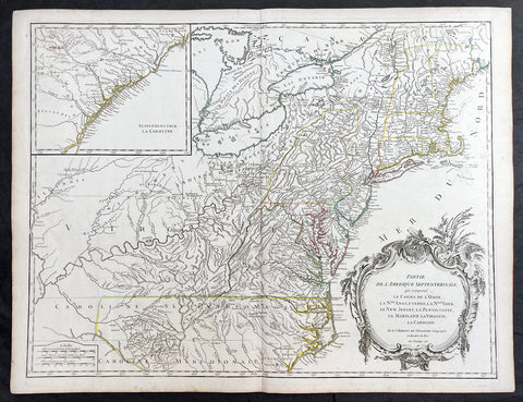
1755 (1768) Robert De Vaugondy Large Antique 2nd edition Map of Colonial United States
- Title : Partie De L Amerique Septentrionale, qui Comprend Le Cours De L Ohio...Par le Sr Robert de Vaugondy
- Date : 1755 (1768)
- Condition: (A+) Fine Condition
- Ref: 93514
- Size: 26in x 20 1/2in (660mm x 520mm)
Description:
This large original beautifully hand coloured, scarce 2nd edition antique map of the east coast of the United States, illustrating the course of the Ohio River and stretching from New England to the Carolinas, north to the Great Lakes and south to the Mississippi - with an inset map of The Carolinas - was published in 1768 - dated 1755 in the cartouche - by Robert Du Vaugondy in his Atlas Universal.
This map is all original with hand colour on age toned heavy paper with original margins with a heavy dark ink denoting an early pressing.
General Definitions:
Paper thickness and quality: - Heavy and stable
Paper color : - off white
Age of map color: - Original & later
Colors used: - Yellow, green, blue, pink
General color appearance: - Authentic
Paper size: - 26in x 20 1/2in (660mm x 520mm)
Plate size: - 25in x 19 1/2in (635mm x 495mm)
Margins: - Min 1/2in (12mm)
Imperfections:
Margins: - Light age toning in margins
Plate area: - None
Verso: - None
Background:
Second state of the early de Vaugondy map of the British colonies, with changes after the 1763 Treaty of Paris, with Virginia & Carolina extended to the Mississippi and Pennsylvania extended to Lake Erie. The majority of geographical information is based upon John Mitchells great map of North America from the mid 1750s, also drawing from Lewis, Evans on the Middle British Colonies and Joshua Frys and Peter Jeffersons map of Virginia and Maryland. The Mitchell map was the culmination of many years of British surveying in the North American Colonies and was considered one of the best maps of the continent available to Europeans and Americans in the mid-eighteenth century.
De Vaugondys rendition does not copy the full scope of Mitchells map but instead focuses on the colonies stretching from southern Maine to the Carolinas. In the top left corner is an inset of South Carolina and Georgia. De Vaugondy also pays special attention to the river systems and settlements. This map shows some of the earliest accurate information of the trans-Allegheny regions (the Ohio River, Kentucky, Tennessee and Parts of Ohio) and inland areas to the southeast of the Great Lakes and interior of New England.
Maine is still part of the Massachusetts Bay Colony. During this era. The dispute between New Hampshire and New York over who controlled the area which is now Vermont has been resolved. The outbreak of the French & Indian War (Seven Years War) briefly suspended interest in the disputed area, and it was not until 1764 that the British crown upheld New Yorks claim to Vermont. Included is a beautiful title cartouche in the Rococo style. (Ref: Tooley; M&B)

1662 Joan Blaeu Complete Set of 9 Antique Maps of North America from Atlas Major, 1st Edition
- Titles:
1. Extrema Americae....Terra Nova Francia;
2. Nova Belgica Et Anglia Nova;
3. Nova Virginiae Tabula;
4. Virginiae partis australis, et Floridae;
5. Nova Hispania;
6. Yucatan...Guatimala;
7. Insulae Americanae;
8. Canibales Insulae;
9. Mappa Aestivarum Insularum Alias Barmudas - Sizes: 24in x 20 1/2in (610mm x 520mm)ea
- Condition: (A+) Fine Condition
- Date: 1662
- Ref #: BlaeuNA 1662
Description:
This is a unique opportunity to acquire a complete set of 9 maps of North America published by Joan Blaeus in the monumental & rare 1st 1662 Latin edition of Atlas Major. The maps cover the geographical detail of Canada, North America, Mexico, The Caribbean & Central America. Please see the background section below for details of each map. All maps have wide original margins & colour on strong sturdy paper.
Joan Blaeus 11 volumes of Atlas Major, is considered by many to be the greatest atlas set ever published. It excels in comprehensiveness, engraving, color, and overall production. The first edition was published in Latin in 1662 and was subsequently published in French, Dutch, German, and Spanish over the next 10 years.
On the 23rd of February 1672, a fire broke out in central Amsterdam, that ended the reign of one of the greatest & most prolific publishers of printed maps and atlases in publishing history. The Blaeu family had reached its zenith 10 years previously, with the publication of its greatest achievement, the Atlas Major or Great Atlas, consisting of 11 volumes, with geographical detail reflecting many of the achievements of the Golden Age of the United Netherlands. Blaeus Atlas Major were the most expensive books printed in the 17th century.
General Definitions:
Paper thickness and quality: - Heavy and stable
Paper color : - off white
Age of map color: - Original
Colors used: - Blue, pink, red, green, yellow
General color appearance: - Authentic
Paper size: - 24in x 20 1/2in (610mm x 520mm)
Plate size: - Various, pls see below
Margins: - Min 1in (25mm) min
Imperfections:
Margins: - Pls see below
Plate area: - Pls see below
Verso: - Pls see below
Background:
1. Extrema Americae ( Eastern Canada) - Rare only published in Atlas Major. Derived mainly from the Samuel de Champlain Nouvelle France map of 1632, this map reflects the growing financial importance of the waters of New France to Europe.
Plate: 22 1/2in x 17 3/4in.
Condition: Age toning, text show-through & browning to image.
2. Nova Belgica Et Anglia Nova (New England) - NE America, centering on New York and Manhattan from Virginia to the St Lawrence River. This map is noted for the fact that its primary source is the first manuscript figurative map of Adriaen Block from 1614. Indeed it is the first full representation of it in print. It is one of the earliest to name Nieu Amsterdam. Block, a Dutch fur trader, explored the area between Cape Cod and Manhattan, examining the bays and rivers along the way.
Plate: 19 1/2in x 15 1/2in
Condition: Age toning, text show-through & browning to image.
3. Nova Virginiae Tabula (John Smiths Virginia & Chesapeake Bay) This map was printed from a plate engraved by Dirk Grijp from a previous plates by Henricus Hondius.
Plate: 19in x 15in
Condition: Light age toning
4. Virginiae partis australis, et Floridae Virginia, the Carolinas & Georgia.
Plate: 20in x 15in
Condition: Light age toning
5. Nova Hispania et Nova Galicia Western Mexico
Plate: 19 1/2in x 15 1/2in
Condition: Light age toning
6. Yucatan...Guatimala (Yucatan, Central America) Rare only published in Atlas Major.
Plate: 20 1/2in x 16 1/2in
Condition: Light age toning
7. Insulae Americana (GOM, Caribbean)
Plate: 20 1/2in x 15in
Condition: Light age toning
8. Canibales Insulae (Lesser Antilles Islands) Rare, printed only in Atlas Major
Plate: 21in x 16 1/2in
Condition: Age toning
9. Mappa Aestivarum Insularum Alias Barmudas Dictarum Bermuda. Like all 17th century maps of Bermuda this map is based ultimately on the survey made by John Norwood, of the Bermuda Company, in 1618 in the form as published by the English map-maker John Speed in 1627.
Plate: 21in x 16in
Condition: Light age toning
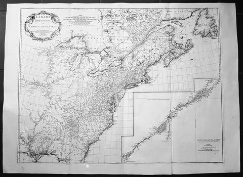
1755 JB D Anville Large Original Antique Map of North America, Great Lakes, Indian Wars
- Title : Canada Louisiane et Terres Anglois Par Le Sr. D Anville...MDCCLV
- Ref #: 61140
- Size: 52in x 38in (1.32m x 960mm)
- Date : 1755
- Condition: (A+) Fine Condition
Description:
This magnificent, scarce, very large (52in x 38in) & highly detail map of North America was engraved in 1755 - dated in the title cartouche - by George De La Haye and was published by Jean Baptiste Bourguignon D Anville in his large elephant folio atlas Atlas Generale.
Geopolitically this map is extremely significant drawn as war between the Global Powers of the day, France, England & Spain, was breaking, known in Europe as the Seven Year War known in North America as the French & Indian war. (Please see below for more detail)
This map rivals John Mitchells "A Map of the British and French Dominions in North America published in 1755" - considered to be one of the most significant maps of North America published in the 18th & 19th centuries (a 1st edition of Mitchells map is currently for sale for $165,000).
I have included an image of the Mitchell map for comparison. The D Anville map is considered by many to be cartographically superior to the Mitchell map, at a fraction of the price.
General Description:
Paper thickness and quality: - Heavy and stable
Paper color: - White
Age of map color: -
Colors used: -
General color appearance: -
Paper size: - 52in x 38in (1.32m x 960mm)
Plate size: - 45in x 35in (1.12m x 890mm)
Margins: - Min 1in (25mm)
Imperfections:
Margins: - None
Plate area: - Light ceasing along folds
Verso: - Very small worm holes
Background: This extraordinary map of the eastern half of North America extends from Newfoundland, Canada to St. Augustine, Florida, stretching westward beyond the Mississippi as far as modern day Texas. The map includes both the original colonial colonies along the Atlantic seaboard from Maine to Georgia and the French claims in Louisiana (the Mississippi Valley) and modern day Canada. Florida is acknowledged as a Spanish enclave. Elevation is rendered in profile with fortifications, towns, and American Indian villages identified. A large inset map centres on the course of the St. Lawrence River from the Isle Aux Coudres to Lake Ontario.
The is a very significant map, drawn from a definitive French perspective, defining the territorial alignments and claims within North America shortly following the outbreak of the French and Indian War, considered to be a New World reflection of the European Seven Years War. It is however notable that it began before the larger hostilities in Europe and most of the major battles involved primarily parties only loosely aligned with the French or English - most specifically American Indians and lawless frontiersman, who had their own political agenda.
The war began with French incursions into western Pennsylvania and other territories claimed simultaneously by the French, English and American Indian forces. Just prior to the war, the French, in the interest of broadening their hold on the lucrative fur trade, established a series of forts, all of which are here noted, along the length of the Mississippi and further east, including Fort Duquesne (here Fort de Quene, Pittsburgh), Fort de la Presquisle, and for Le Beouf (here, Fort de la Riv Jaus Beufs).
The map also recognizes British claims, only inland as far as the Appalachian Mountains, beyond which place names take on a noticeably French character. These last three forts occupied particularly contested territory under the control of the powerful British allied Iroquois League. The most contested of these was Fort Duquesne (modern day Pittsburgh) in direct opposition to another fort then being constructed by the Ohio Company, a trading and land speculation firm established by prominent Virginia colonials, including George Washington. The Virginian colonial governor responded to Duquesne by sending then Lieutenant George Washington and a band of Virginia militiamen to harass the French. The resulting Jumonville Affair, in which Washington oversaw an attack on a French Canadian diplomatic forces led by Joseph Coulon de Villiers de Jumonville, to warn the Ohio Company fort builders away from French claimed territory. The slaying of Jumonville and several other French diplomats prompted a response from French forces at Fort Duquesne, leading to Washingtons retreat and construction of Fort Necessity, really little more than a palisaded shack, marked here just south of Fort Duquesne. These events, all of which occurred in May of 1754, were said to have increased hostilities in Europe and led to the start of the Seven Year War in 1755.
Beyond the political agenda of this map, is the map itself, being one of the finest and most heavily detailed maps of North America published in the mid 18th century. Ranking alongside the large 1755 Mitchell map in detail but judged by many as cartographically superior. Drawing on both French and British cartographical detail, D Anville identifies countless American Indian tribes, many of which, like the Sioux and Missouri, the British had only vague knowledge. Moreover, he also includes detail such as swamps, rapids, fords, abandoned villages, and even the ancient remnants of mound builder culture in the Ohio Valley. D Anville notably does not include Mitchells fictional Lake Superior islands.
This map was originally published to accompany the pamphlet entitledMemoire sur la carte intitulee: Canada, Louisiane, & Terres angloises and was also published in four parts for D Anvilles Atlas General.
These large maps are hard to find in such good condition and make fantastic historical reference tools due to the size and high level of detail as with all D Anvilles work. (Ref: Tooley, M&B)
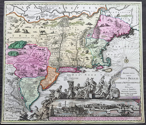
1730 Georg Seutter Antique Map of New England & New York City - Rare 2nd State
- Title : Recens edita totius Novi Belgii, in America Septentrionali siti, delineatio cura et sumtibus Matthaei Seutteri, Sac. Caes Maj. Geographf. August. Vind
- Size: 23in x 20 1/4in (585mm x 515mm)
- Condition: (A) Very Good Condition
- Date : 1730
- Ref #: 43001
Description:
This large beautifully hand coloured original antique map of the NE region of colonial North America, with the famous Restitutio inset birds-eye view of 17th century New York city, was engraved & published by Georg Mattraus Seutter in 1730.
This is the rare second state, identified by the omission of Chalcographi Augustani from the title and the blank shaded are directly below the title (text was added to the shaded area in the 3rd to 6th states) The cartouche and city view are uncoloured as was intended by Seutter along with the beautiful original map colouring.
This map is in exceptional condition with beautiful original colour, with heavy engraving (denoting an early pressing) on clean heavy sturdy paper. The top and left borders have been professionally extended, with no impact on the image.
There are, at the time of listing, nine of these maps for sale online, of states 2 to 6. Of the 9 only 2 are of the rare 2nd state. The average asking price of the nine maps is $4897US.
General Definitions:
Paper thickness and quality: - Heavy and stable
Paper color : - off white
Age of map color: - Original
Colors used: - Blue, pink, red, green, yellow
General color appearance: - Authentic
Paper size: - 23in x 20 1/4in (585mm x 515mm)
Plate size: - 23in x 20 1/4in (585mm x 515mm)
Margins: - Min 1/4in (5mm)
Imperfections:
Margins: - T & L margins extended
Plate area: - None
Verso: - None
Background:
The map is based upon the Jansson-Visscher New England series of maps, first published by Visscher in 1651. Seutter replaces the original Restitutio view of New York City with a new view of New York entitled Neu Jorck sive Neu Amsterdam, with a key to the view below in Latin. Above the view is an elaborate scene depicting natives, slaves & allegorical deities presenting tributes to the English monarch, George II. The course of the Delaware and Hudson are separated, unlike early editions of the map.
This is the first map in the series to show distinct drawn boundaries between Massachusetts, New England, New York, New Jersey and Pennsylvania, as earlier examples had previously left the delineation of the boundaries to the colorist. Philadelphia is now shown as a set of houses in relief, rather than a ground plan. The map is richly embellished with many animals and other decorations and is without doubt, one of the most decorative 18th century maps of the region.
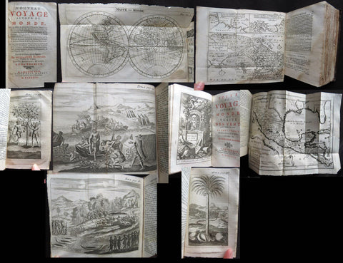
1723 William Dampier 2 Volumes of World Voyages to America Australia Asia - 20 x Maps & Plates
- Title : Nouveau Voyage Autour Du Monde...Ou l on decrite en particular l Isthme de l Amerique, plusieurs côtes et isles des Indes Occidentales...1723
- Size: 8vo
- Condition: (A) Very Good Condition
- Date : 1723
- Ref #: 93005
Description:
These two beautiful leather bound volumes of William Dampiers voyages to America, New Holland (Australia) and the East Indies, contains 5 titles with 20 maps & plates (some folding) and was published in Amsterdam by David Paul Marret in 1723 (dated)
These 2 volumes are the French translation of the voyages of the English explorer, ex-pirate and navigator, William Dampier, who became the first Englishman to explore parts of what is today Australia, and the first person to circumnavigate the world three times between 1679 & 1711. He has also been described as Australia\'s first natural historian, as well as one of the most important British explorers of the period between Sir Walter Raleigh and James Cook.
After impressing the British Admiralty with his book, A New Voyage Round the World, Dampier was given command of a Royal Navy ship and made important discoveries in western Australia, but was court-martialled for cruelty. On a later voyage, he rescued Alexander Selkirk, a former crew mate who may have inspired Daniel Defoe\'s Robinson Crusoe. Others influenced by Dampier include James Cook, Lord Nelson, Charles Darwin and Alfred Russel Wallace.
General Definitions:
Paper thickness and quality: - Heavy and stable
Paper color : - off white
Age of map color: -
Colors used: -
General color appearance: -
Paper size: - 8vo
Plate size: - 8vo
Margins: - Min 1/2in (12mm)
Imperfections:
Margins: - Please see below for condition report
Plate area: - Please see below for condition report
Verso: - Please see below for condition report
Background:
The two volumes contain the following 5 titles with 20 maps & plates.
Volume 1.
1. Nouveau Voyage Autour Du Monde...Ou l\'on decrite en particular l\'Isthme de l\'Amerique, plusieurs côtes et isles des Indes Occidentales, les Isles du Cap Verd, le passage par la Terre del Fuego, les côtes meridionales du Chili, du Perou & du Mexique; l\'Isle de Guam, Mindanao, & des autres Philippines, les isles orientales qui sont prés de Cambodie; de la Chine; Formosa; Luçon, Celebes, &c., la Nouvelle Hollande, les Isles de Sumatra, de Nicobar & de Sainte Helene & le Cap de Bonne Esperance...Ou l\'on traite des differens terroirs de tous ces pays, de leurs ports, des plantes, des fruits & des animaux qu\'on y trouve; de leurs habitans, de leurs coûtumes, de leur religion, de leur gouvernement, de leur negoce, &c....1723
This volume refers to Dampiers voyages to North & South America, East Indies, SE Asia, China, Australia & Africa.
Contains Title page, 8 maps & plates total of 340 pages.
a) Mappe-Monde - World map with Dampiers tracks.
b) Maps of the Isthmus of Panama and Central America
c) Print of Natives gathering fruit
d) Print of Dampier loading Gold from the New World
e) Voyage au tour du Monde title page
f) Map of Mexico & southern North America
g) Print of a battle in the East indies
h) Print of a coconut palm in East Indies
2. Suite du Voyage Autour du Monde... Avec un Traite Des Vents qui regnent dans toute..LA ZONE TORRIDE Enrichi de Cartes & de Figures..1723
This volume refers to the contuinuation of Dampiers voyages to North & South America, East Indies, SE Asia, China, Australia & Africa along with a description of global winds and tides.
Contains title page along with 6 maps & plates, 227 pages.
a) Engraved Voyage au Tour Du Monde
b) Print of ships offshore from the city of Manila in the Phillippines
c) View of Manila
d) 2nd print of ships offshore from the city of Manila in the Phillippines
e) Map of the Philippines islands of Banshee
f) Map of Pulocondor, Malayia
g) Print of Dampiers ship and compass rose
3. Traits des Vents Aliisez ou Reglez des Vents Frais ...1715
This volume refers again to globle winds & tides.
Contains title page 2 maps & 148 pages
a) Description of winds and tides in the eastern hemisphere
b) Description of winds and tides in the eastern hemisphere
Volume 2.
1. Voyage Autour Du Monde... Contenant une Description d\'Achin,
Ville de Sumatra, du Royaume de Tonquin & autres Places des Indes,
& de la Baye de Campeche. Ou l\'on traite des differens terroirs de tous ces pays, de leurs ports, des plantes, des fruits & des animaux qu\'on y trouve; de leurs
habitans, de leurs coûtumes, de leur religion, de leur gouvernement,
de leur negoce, &c...1723
This volume refers to the continuation of Dampiers travels in East Indies, SE Asia & Mexico
Contains title page, 4 maps & plates, 264 pages.
a) Royalty in Vietnam
b) Map of central & north America
b) Print of Vietnam
c) Map of Australia & East Indies
2. Voyages de Guillaume Dampier a la Baye de Campeche...1714
This volume refers to Dampiers travel to Campeche, Mexico.
Contains title page and 197 pages.
Condition Report: Two volumes bound in full leather with five raised bands to spines, and title label. Couple of minor chips to top of both spines. The leather is scuffed and little pitted/worn (see photos). Internally there are a couple of small chips to inner edges of front and rear end-papers. Inscription to front end-papers (Gift of W. Wood 1745) and bookplate to inside front board (Lord Sandys). The title page of volume III and following four or so leaves have damp staining, and there is light damp staining throughout Volume I & II. The damp staining has caused the leaves to become softer and little chipped, with some nicks/tears and chips. There is a tear/crease to top inner edge and chip to bottom corner of title page of volume I. Scattered pale foxing/browning. Several of the plates have occasional creases. Four leaves of volume III are gently detaching and two leaves of volume I are missing. A few leaves are a little faded. Overall VG, in readable with firm binding.
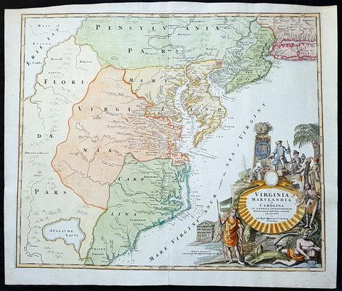
1715 J B Homann Large Antique Map of North America Virginia Chesapeake Bay NJ, NY
- Title : Virginia Marylandia et Carolina in America Septentrionali Britannorum industria excultae"...Homann
- Date : 1715
- Condition: (A+) Fine Condition
- Ref: 82002
- Size: 24 1/2in x 21 1/4in (625mm x 540mm)
Description:
This large finely engraved beautifully hand coloured original antique map of Virginia, Chesapeake Bay, Maryland, the Carolina's, New Jersey, Pennsylvania, Maryland, New York and parts west of the Apalchians, was published by J.B Homann in 1715.
An exceptionally beautiful example of J. B. Homann's 1715 map of Virginia, Carolina, Maryland, and New Jersey; considered one of the most important and decorative maps of is region to appear in the 18th century. This fine decorative map covers from New York City and Long Island south along the Atlantic Cost as far as modern day Georgia, and as far west as Lake Erie.
General Description:
Paper thickness and quality: - Heavy and stable
Paper color: - off white
Age of map color: - Original & later
Colors used: - Yellow, green, blue, pink
General color appearance: - Authentic
Paper size: - 24 1/2in x 21 1/4in (625mm x 540mm)
Plate size: - 23in x 19 1/2in (580mm x 490mm)
Margins: - Min 1/2in (12mm)
Imperfections:
Margins: - None
Plate area: - None
Verso: - None
Background:
Homann drew this map in response to Virginia Lieutenant-Governor Alexander Spotswood's plan to settled the little known interior of Virginia with German immigrants. Shown here is the first mapping of Germantown Teutsche Statt on the Rappahanock River and Fort Christanna (Christ Anna Fort) on the Makharing River. Fort Christanna was built with the intention of defending the region against incursions from hostile American Indian groups such as the Tuscarora to the west. Christanna also acted as the headquarters of the Virginia Indian Company, a stock venture founded in 1714 with the intention of trading with indigenous groups in the interior.Though Homann's remarkable representation of Spottswood's plan is extraordinarily up-to-date considering that Fort Christana was founded in the same year that this map was initially published, the remainder of the map embraces a number of common misconceptions and cartographic inaccuracies common to the region. Probably the most notable of these is his inclusion of Apalache Lacus. This fictional lake, the source of the May River, appeared on maps of this region since the mid 16th century Le Moyne-De Bry map and was popularized by Mercator and Hondius in 1606.
It would remain on maps well into the mid 18th century before exploration and settlement finally disproved the theory. Further north Lake Erie and been expanded dramatically and shifted somewhat to the south where it takes on the appearance of a vast inland sea occupying the entire northwestern quadrant of the map. This region, west of the English colonies and north as far as Pennsylvana, Homann attaches to the Spanish claims in Florida.
Homann's also offers a wealth of detail along the Atlantic coast, where most of the European colonization efforts were focused. From Long Island, about two-thirds of which is shown, south to Craven County, Carolina, countless towns and cities are identified. New York City is mapped on the southern tip of Manhattan Island, but is not specifically labeled. New Jersey is divided into the colonial provinces of East New Jersey and West New Jersey. Curiously Homann maps a large inland lake "Zuyd Lac" straddling the New Jersey - Pennsylvania border. This is no doubt a early misinterpretation of the natural widening of the Delaware River at the Delaware Water Gap. Heading south along the Delaware River Philadelphia is identified and beautifully rendered as a grid embraced in four quadrants. Both the Delaware Bay and the Chesapeake Bay are rendered in full and even include a number of undersea notations and depth soundings. In Virginia and Carolina the river systems are surprisingly well mapped and a primitive county structure is beginning to emerge.
The early Virginia counties of Rappahannock, Henrico, City, Isle of Wright, Nansemond, Northumberland, Middlesex, Gloster and Corotvk are noted. Similarly in Carolina a number of counties are named, most of which refer to the Lords Proprietors, including Albemarle, Clarenden, and Craven. Cape Fear, Cape Lookout, and Cape Hattaras are noted and a number of anchorages, reefs, and depth sounding are noted along the entire coastline. The lower right quadrant of this map is occupied by a fabulous decorative title cartouche. Centered on an enormous scallop shell bearing the map's title and Homann's Privilege, the cartouche features a number of stylized American Indians trading with European merchants.
The wealth of the region is expressed by an abundance of fish, game, and other trade products. Curling behind the scallop shell is a gigantic stylized alligator looking like nothing so much as a mediaeval dragon. The inclusion of Homann's Provildge in the title cartouche helps us to date this map to about 1715, when Homann was granted the right to add this royal distinction to his maps. (Ref: Tooley; M&B)
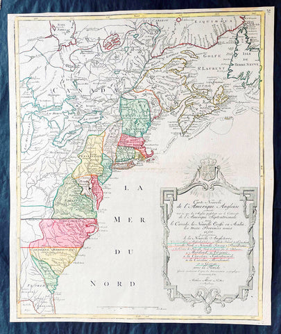
1776 Tobias Lotter Large Antique Post Revolutionary North America Map 13 Colonies
- Title : Carte Nouvelle de l Amerique Angloise Contenant Tout ce que les Anglois Possedent sur le Continent de l'Amerique Septentrionale Savior le Canada, la Nouvelle Ecosse ou Acadie, les Treize Provinces Unies ... avec la Floride
- Ref #: 27009
-
Condition: (A+) Fine Condition
- Size: 25in x 21 1/2in (635mm x 545mm)
- Date : 1776
Description:
This is possibly one of the last significant maps, of the original 13 American colonies, published prior to the American Revolution for Independence from Britain, beginning in 1763 and ending with the signing of the Declaration of Independence in 1776.
Published in Augsberg, Germany in 1776 by Conrad Tobias Lotter, this large original antique map reflects both the French & German interests in North America just prior to the outbreak of hostilities.
The map covers the area from the James Bay to the Gulf of Mexico and west to Lake Michigan. It shows provinces, towns and cities, some forts and trails, as well as Indian villages and tribal territory. (Ref: Tooley, M&B)
General Definitions:
Paper thickness and quality: - Heavy and stable
Paper color : - off white
Age of map color: - Original & later
Colors used: - Yellow, green, blue, pink
General color appearance: - Authentic
Paper size: - 25in x 21 1/2in (635mm x 545mm)
Plate size: - 24in x 19 1/2in (610mm x 495mm)
Margins: - Min 1/2in (12mm)
Imperfections:
Margins: - None
Plate area: - None
Verso: - None
Background:
Each of the thirteen Colonies is identified by name both on the map, and in the title. The title is placed within an attractive decorative border surmounted by the British Royal arms. The French title and nomenclature indicates that Lotter, a leading German mapmaker, intended this for the French market, as does the fact that he limits the claims of the British to the regions east of the Appalachian Mountains. The delineation of the thirteen Provinces unies is generally well done (although Maryland and Georgia are both strangely shaped): a number of locations are named in the Ohio Valley, including Logs Town, Twictwees, Ft. Du Quesne, Allegheny, Vinango, Buffaloons, Sandoski and Mingos. Some interesting details are also shown in the region of the Great Lakes.
Please note all items auctioned are genuine, we do not sell reproductions. A Certificate of Authenticity (COA) can be issued on request.
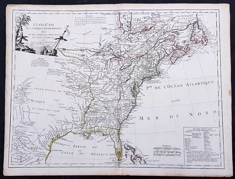
1785 De Vaugondy & Jefferson Antique Early Map of The United States of America
- Title : Etats-Unis de l'Amerique Septentrionale avec les Isles Royale, de Terre Neuve de St. Jean, l'Acadie &c. 1785 M. Robert de Vaugondy....Boudet....
- Date : 1785
- Condition: (A+) Fine Condition
- Ref: 93513
- Size: 26in x 20 1/2in (660mm x 520mm)
Description:
This large original hand coloured copper-plate engraved very important, early & scarce antique early map of the United States (Etats-Unis De L Amerique), during what is know as the Confederation Period, by Robert De Vaugondy was published by the French printer Antoine Boudet (1715 - 1787) for the supplement of de Vaugondys Atlas Universal
This scarce first state map is very important to the formation of the United States of America. The map is the first to describe what is know as the Jeffersonian Ordinance, showing the new international borders of the fledgling United States, the inclusion of the original 13 states in the bottom right text box (the first map to do so) along with the inclusion of Michigan, ratified under the Treaty of Paris in 1783.
The successor to De Vaugondy, Charles Francois Delamarche (1740 - 1817) was a known correspondent to Thomas Jefferson and along with the printer Boudet would have played an important part in the publication of this map. The Ordinance of 1784 was a plan to outline the new territories and states, that would eventually make up the foundation of the United States, ratified by the Treaty of Paris. Given that this map was engraved in 1785 or possibly earlier and that Delamarche was a friend of Jefferson, it is not a stretch to believe that he was one of the first, if not the first, to map the new country of the United States (Etats-Unis De L Amerique)
General Definitions:
Paper thickness and quality: - Heavy and stable
Paper color : - off white
Age of map color: - Original
Colors used: - Yellow, green, blue, pink
General color appearance: - Authentic
Paper size: - 26 1/2in x 20 1/2in (670mm x 520mm)
Plate size: - 25 1/2in x 19 1/2in (650mm x 500mm)
Margins: - Min 1/2in (12mm)
Imperfections:
Margins: - Light age toning in margins
Plate area: - Light creasing along centerfold
Verso: - None
Background:
The Confederation Period was the era of United States history in the 1780s after the American Revolution and prior to the ratification of the United States Constitution. In 1781, the United States ratified the Articles of Confederation and prevailed in the Battle of Yorktown, the last major land battle between British and American forces in the American Revolutionary War. American independence was confirmed with the 1783 signing of the Treaty of Paris. The fledgling United States faced several challenges, many of which stemmed from the lack of a strong national government and unified political culture. The period ended in 1789 following the ratification of the United States Constitution, which established a new, more powerful, national government.
The Articles of Confederation established a loose confederation of states with a weak federal government. An assembly of delegates acted on behalf of the states they represented. This unicameral body, officially referred to as the United States in Congress Assembled, had little authority, and could not accomplish anything independent of the states. It had no chief executive, and no court system. Congress lacked the power to levy taxes, regulate foreign or interstate commerce, or effectively negotiate with foreign powers. The weakness of Congress proved self-reinforcing, as the leading political figures of the day served in state governments or foreign posts. The failure of the national government to handle the challenges facing the United States led to calls for reform and frequent talk of secession.
The Treaty of Paris left the United States with a vast territory spanning from the Atlantic Ocean to the Mississippi River. Settlement of the trans-Appalachian territories proved difficult, in part due to the resistance of Native Americans and the neighboring foreign powers of Great Britain and Spain. The British refused to evacuate US territory, while the Spanish used their control of the Mississippi River to stymie Western settlement. In 1787, Congress passed the Northwest Ordinance, which set an important precedent by establishing the first organized territory under the control of the national government.
After Congressional efforts to amend the Articles failed, numerous national leaders met in Philadelphia in 1787 to establish a new constitution. The new constitution was ratified in 1788, and the new federal government began meeting in 1789, marking the end of the Confederation Period. Some historians believe that the 1780s were a bleak, terrible time for the US, while others have argued that the period was actually stable and relatively prosperous.
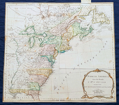
1775 Thomas Jefferys Antique Map North America & Colonial States, Pre Revolution
- Title : North America from the French of Mr. D Anville Improved with the English Surveys made Since the Peace NB. The Boundaries of the Provinces since the conquest of Canada are laid down as settled by the King in Council..London Printed for Robt. Sayer & J Bennett Map & Printseller, No 53 Fleet Street as the act directs 10 June 1775
- Size: 20 1/2in x 18 1/2in (510mm x 470mm)
- Condition: (A) Very Good Condition
- Date : 1775
- Ref #: 93045
Description:
This very important scarce original copper-plate engraved antique map of North America & the colonial States, is sectioned and laid down on linen as issued. The map by Thomas Jefferys - after JB D Anville, was engraved in 1775 - dated at the foot of the map - and was published by Robert Sayer and John Bennett, London.
Jean Baptiste Bourguignon d Anville was the successor to Guillaume De l Isle and maintained the rigorous standard for accuracy that De l Isle had established. D Anville was the last French mapmaker to establish an international reputation, superior to all his contemporaries, with respect shown by the English and other cartographers and publishers during an era when England & France were often at conflict with one another.
General Definitions:
Paper thickness and quality: - Heavy and stable
Paper color : - off white
Age of map color: - Original
Colors used: - Yellow, green, pink
General color appearance: - Authentic
Paper size: - 20 1/2in x 18 1/2in (510mm x 470mm)
Plate size: - 20 1/2in x 18 1/2in (510mm x 470mm)
Margins: - Min 0in (0mm)
Imperfections:
Margins: - Bottom right margin cropped to border
Plate area: - Spotting
Verso: - Linen strong and robust, spotting
Background:
This third state is the second edition of the map issued after the conclusion of the French and Indian War. The map shows the Colonies on the eve of the American Revolutionary War. A note in the title cartouche states that the Boundaries of the Provinces since the conquest of Canada are laid down as settled by the King in Council. This note appears in the second state as well. The map shows the various colonial claims running to the Mississippi, but the colourist has conservatively limited the borders to the Appalachian Mountains. The boundary between New England and Virginia as established by Charter in 1609 is shown, although the date is omitted.
The map is rich with details west of the Appalachians, including Indian Tribes, early French and English forts and other contemporary information on the eve of the revolution. Main is named, but [New] Hampshire takes up all of Vermont. Massachusetts Bay and Delaware Bay are named, as are East and West Florida. The region west of the Mississippi is dominated by Spanish Louisiana Territory, with the lands between the Mississippi and the Appalachians controlled by Indian Tribes. A nice wide margin example of this map of the Colonies, which was included in Jefferys American Atlas prior to and during the American Revolutionary War.

1785 Antonio Zatta Large Antique Map of Southern United States, Texas, Mexico
- Title : Messico ouvero Nuova Spagna che contiene Il Nuovo Messico La Californoa Con Una Partie de Paesi Adjacenti Venezi 1785
- Ref #: 93526
- Size: 21in x 15in (535mm x 385mm)
- Date : 1785
- Condition: (A+) Fine Condition
Description:
This large beautifully hand coloured original antique map of Mexico including Texas, California, and the Southern United States was engraved in 1785 - the date is engraved in the title cartouche - and was published by Antonio Zatta in his Atlas Atlante Novissimo. (Ref: Tooley; M&B)
General Definitions:
Paper thickness and quality: - Heavy and stable
Paper color : - off white
Age of map color: - Original
Colors used: - Blue, pink, red, green, yellow
General color appearance: - Authentic
Paper size: - 21in x 15in (535mm x 385mm)
Plate size: - 16in x 12 1/2in (405mm x 320mm)
Margins: - Min 1in (25mm)
Imperfections:
Margins: - None
Plate area: - None
Verso: - None
Background:
The capture of Tenochtitlan and refounding of Mexico City in 1521 was the beginning of a 286-year-long colonial era during which Mexico was known as Nueva España (New Spain). The Kingdom of New Spain was created from the remnants of the Aztec hegemonic empire. Subsequent enlargements, such as the conquest of the Tarascan state, resulted in the creation of the Viceroyalty of New Spain in 1535. The Viceroyalty at its greatest extent included the territories of modern Mexico, Central America as far south as Costa Rica, and the western United States. The Viceregal capital Mexico City also administrated the Spanish West Indies (the Caribbean), the Spanish East Indies (the Philippines), and Spanish Florida.
The indigenous population stabilized around one to one and a half million individuals in the 17th century from the most commonly accepted five to ten million pre-contact population. The population decline was primarily the result of communicable diseases, particularly smallpox, introduced during the Columbian Exchange. During the three hundred years of the colonial era, Mexico received between 400,000 and 500,000 Europeans, between 200,000 and 250,000 Africans and between 40,000 and 120,000 Asians. The 18th century saw a great increase in the percentage of mestizos.
Colonial law with Spanish roots was introduced and attached to native customs creating a hierarchy between local jurisdiction (the Cabildos) and the Spanish Crown. Upper administrative offices were closed to native-born people, even those of pure Spanish blood (criollos). Administration was based on the racial separation, among Republics of Spaniards, Amerindians and castas, autonomous and directly dependent on the king himself.
The Council of Indies and the mendicant religious orders, which arrived in Mesoamerica as early as 1524, labored to generate capital for the crown of Spain and convert the Amerindian populations to Catholicism. The 1531 Marian apparitions to Saint Juan Diego gave impetus to the evangelization of central Mexico. The Virgin of Guadalupe became a symbol of criollo patriotism and was used by the insurgents that followed Miguel Hidalgo during the War of Independence. Some Crypto-Jewish families emigrated to Mexico to escape the Spanish Inquisition.
The rich deposits of silver, particularly in Zacatecas and Guanajuato, resulted in silver extraction dominating the economy of New Spain. Taxes on silver production became a major source of income for Spain. Other important industries were the haciendas (functioning under the encomienda and repartimiento systems) and mercantile activities in the main cities and ports. Wealth created during the colonial era spurred the development of New Spanish Baroque.
As a result of its trade links with Asia, the rest of the Americas, Africa and Europe and the profound effect of New World silver, central Mexico was one of the first regions to be incorporated into a globalized economy. Being at the crossroads of trade, people and cultures, Mexico City has been called the first world city. The Nao de China (Manila Galleons) operated for two and a half centuries and connected New Spain with Asia. Goods were taken from Veracruz to Atlantic ports in the Americas and Spain. Veracruz was also the main port of entry in mainland New Spain for European goods, immigrants, and African slaves. The Camino Real de Tierra Adentro connected Mexico City with the interior of New Spain. Mexican silver pesos became the first globally used currency and the silver mined in Mexico were used to run commerce and wage crusades in two sides of globe, at the Mediterranean were Spain fought against the Ottoman Caliphate and at Southeast Asia where the Philippines fought against the Brunei Sultanate.
Due to the importance of New Spain administrative base, Mexico was the location of the first printing shop (1539), first university (1551), first public park (1592), and first public library (1646) in the Americas, amongst other institutions. Important artists of the colonial period, include the writers Juan Ruiz de Alarcón and Sor Juana Inés de la Cruz, painters Cristóbal de Villalpando and Miguel Cabrera, and architect Manuel Tolsá. The Academy of San Carlos was the first major school and museum of art in the Americas. Scientist Andrés Manuel del Río Fernández discovered the element vanadium.
Spanish forces, sometimes accompanied by native allies, led expeditions to conquer territory or quell rebellions through the colonial era. Notable Amerindian revolts in sporadically populated northern New Spain include the Chichimeca War (1576–1606), Tepehuán Revolt (1616–1620) and the Pueblo Revolt (1680). To protect Mexico from the attacks of English, French and Dutch pirates and protect the Crowns monopoly of revenue, only two ports were open to foreign trade—Veracruz on the Atlantic and Acapulco on the Pacific. Among the best-known pirate attacks are the 1663 Sack of Campeche and 1683 Attack on Veracruz.
Many Mexican cultural features including tequila, first distilled in the 16th century, charreria (17th), mariachi (18th) and Mexican cuisine, a fusion of American and European (particularly Spanish) cuisine, arose during the colonial era.
On September 16, 1810, a loyalist revolt against the ruling junta was declared by priest Miguel Hidalgo y Costilla, in the small town of Dolores, Guanajuato. This event, known as the Cry of Dolores (Spanish: Grito de Dolores) is commemorated each year, on September 16, as Mexicos independence day. The first insurgent group was formed by Hidalgo, the Spanish viceregal army captain Ignacio Allende, the militia captain Juan Aldama and La Corregidora Josefa Ortiz de Domínguez. Hidalgo and some of his soldiers were captured and executed by firing squad in Chihuahua, on July 31, 1811. Following his death, the leadership was assumed by priest José María Morelos, who occupied key southern cities.
In 1813 the Congress of Chilpancingo was convened and, on November 6, signed the Solemn Act of the Declaration of Independence of Northern America. Morelos was captured and executed on December 22, 1815.
In subsequent years, the insurgency was near collapse, but in 1820 Viceroy Juan Ruiz de Apodaca sent an army under the criollo general Agustín de Iturbide against the troops of Vicente Guerrero. Instead, Iturbide approached Guerrero to join forces, and on August 24, 1821 representatives of the Spanish Crown and Iturbide signed the Treaty of Córdoba and the Declaration of Independence of the Mexican Empire, which recognized the independence of Mexico under the terms of the Plan of Iguala.
Mexicos short recovery after the War of Independence was soon cut short again by the civil wars and institutional instability of the 1850s, which lasted until the government of Porfirio Díaz reestablished conditions that paved the way for economic growth. The conflicts that arose from the mid-1850s had a profound effect because they were widespread and made themselves perceptible in the vast rural areas of the countries, involved clashes between castes, different ethnic groups and haciendas, and entailed a deepening of the political and ideological divisions between republicans and monarchists.
Agustín de Iturbide became constitutional emperor of the First Mexican Empire in 1822. A revolt against him in 1823 established the United Mexican States. In 1824, a Republican Constitution was drafted and Guadalupe Victoria became the first president of the newly born country. Central America, including Chiapas, left the union. In 1829 president Guerrero abolished slavery. The first decades of the post-independence period were marked by economic instability, which led to the Pastry War in 1836. There was constant strife between Liberals, supporters of a federal form of government, and Conservatives, who proposed a hierarchical form of government.
During this period, the frontier borderlands to the north became quite isolated from the government in Mexico City, and its monopolistic economic policies caused suffering. With limited trade, the people had difficulty meeting tax payments and resented the central governments actions in collecting customs. Resentment built up from California to Texas. Both the mission system and the presidios had collapsed after the Spanish withdrew from the colony, causing great disruption especially in Alta California and New Mexico. The people in the borderlands had to raise local militias to protect themselves from hostile Native Americans. These areas developed in different directions from the center of the country.
Wanting to stabilize and develop the frontier, Mexico encouraged immigration into present-day Texas, as they were unable to persuade people from central Mexico to move into those areas. They allowed for religious freedom for the new settlers, who were primarily Protestant English speakers from the United States. Within several years, the Anglos far outnumbered the Tejano in the area. Itinerant traders traveled through the area, working by free market principles. The Tejano grew more separate from the government and due to its neglect, many supported the idea of independence and joined movements to that end, collaborating with the English-speaking Americans.
General Antonio López de Santa Anna, a centralist and two-time dictator, approved the Siete Leyes in 1836, a radical amendment that institutionalized the centralized form of government. When he suspended the 1824 Constitution, civil war spread across the country. Three new governments declared independence: the Republic of Texas, the Republic of the Rio Grande and the Republic of Yucatán.
The 1846 United States annexation of the Republic of Texas and subsequent American military incursion into territory that was part of Coahuila (also claimed by Texas) instigated the Mexican–American War. The war was settled in 1848 via the Treaty of Guadalupe Hidalgo. Mexico was forced to give up more than one-third of its land to the U.S., including Alta California, Santa Fe de Nuevo México and the territory claimed by Texas. A much smaller transfer of territory in what is today southern Arizona and southwestern New Mexico—known as the Gadsden Purchase—occurred in 1854.
The Caste War of Yucatán, the Maya uprising that began in 1847, was one of the most successful modern Native American revolts. Maya rebels, or Cruzob, maintained relatively independent enclaves in the peninsula until the 1930s.
Dissatisfaction with Santa Annas return to power led to the liberal Plan of Ayutla, initiating an era known as La Reforma. The new Constitution drafted in 1857 established a secular state, federalism as the form of government, and several freedoms. As the Conservatives refused to recognize it, the Reform War began in 1858, during which both groups had their own governments. The war ended in 1861 with victory by the Liberals, led by president Benito Juárez, who was an ethnic Zapotec.
In the 1860s Mexico was occupied by France, which established the Second Mexican Empire under the rule of the Habsburg Archduke Ferdinand Maximilian of Austria with support from the Roman Catholic clergy and the Conservatives. The latter switched sides and joined the Liberals. Maximilian surrendered, was tried on June 14, 1867, and was executed a few days later on June 19 in Querétaro.
Please note all items auctioned are genuine, we do not sell reproductions. A Certificate of Authenticity (COA) can be issued on request.
1770 De Vaugondy & Diderot Antique Maps of Cartographical Views of California
- Title : Carte de la Californie suivant / I. La carte manuscrite de l'Amérique de Mathieu Néron Pecci olen dresse à Florence en 1604 / II. Sanson 1656 / III. De L'Isle Amérique Sept. 1700 / IV. le Pere Kino Jesuite en 1705 / V. La Societe des Jésuites en 1767.
- Ref: 93434
- Size: 17in x 14in (430mm x 355mm)
- Date : 1770
- Condition: (A) Very Good Condition
Description:
This fine large historically important original hand coloured, copper-plate engraved antique map, illustrating 5 of the most influential depictions of California and its cartographical evolution between 1604 and 1767.
The map was engraved by the important French cartographer Robert De Vaugondy, for the 1770 edition of the Denis Diderot Encyclopaedie Raisonee des Sciences des Artes.
- The earliest map (upper right corner) is based upon a manuscript map by Mathieu Neron Pecci, drawn in Florence in 1604. This map also forms the basis of a map popularized in 1770 by Rigobert Bonne.
- The second map is Nicholas Sanson's map of California as an Island, based upon his larger map of 1656. This map was probably the single most influential projection of California as an Island.
- The third map map (lower right) is a portion of Guillaume De L'Isles map of America, published in 1700. While not truly peninsular in nature, it was influential in the shift back toward depicting California as a Peninsula.
- The fourth map (upper center) is a portion of Fra. Eusebio Kino's map, generally credited with being the map which dispelled the California as and Island myth. Issued in 1705, the map is based upon Father Kino's overland expedition from the mainland to the top of the Gulf of Cortez.
- The fifth map is one of the most interesting and enduring maps of California and the Baja (left side). Initially issued by the Society of Jesuits in 1767, it was popularized by Isaak Tirion and was perhaps the most interesting of all maps of Baja California in the 2nd half of the 18th Century.
General Definitions:
Paper thickness and quality: - Heavy and stable
Paper color : - off white
Age of map color: - Early
Colors used: - Yellow, pink
General color appearance: - Authentic
Paper size: - 17in x 14in (430mm x 355mm)
Plate size: - 16in x 12in (405mm x 315mm)
Margins: - Min 1/2in (12mm)
Imperfections:
Margins: - Bottom left margin expended from plate mark
Plate area: - Folds as issued
Verso: - None
Background:
This map was 1 of 10 maps to appear in the Supplement to Diderot\'s monumental encyclopedia, one of the most influential and widely distirbuted works of the second half of the 18th Century. Diderot\'s goal was to examine and display the popular geographical conceptions of several different parts of the world where the knowledge of the region\'s geogaphy was still largely unknown and evolving. Other maps treat the Northwest Passage, Northeast Passage and the NW Coast of America, among other topics.
A marvelous amalgam and an essential map for collectors of North American & California maps.
Encyclopaedie Raisonee des Sciences des Artes: At the time of publication these maps of Encyclopedie were some of the most in-depth and accurate maps published of Asia, Canada, California and the NW region of America.
Diderot\'s maps were intended to further an understanding of the Western Coast of America, and NE Asia, during a time period immediately prior to Cook\'s voyage to the region - less than a decade later- where numerous theories abounded on the NW Coast of America.(Ref: Tooley; M&B)
1857 Alexandre Vuillemin Large Antiqque Map of North America...Beautiful
- Title : Nouvelle Carte Illustree L Amerique Du Nord...Vuillemin....1857
- Ref #: 17024
- Size: 35in x 25 1/2in (890mm x 650mm)
- Date : 1857
- Condition: (A) Very Good Condition
Description:
This very large original hand coloured antique lithograph map of North America, with small vignettes of North American peoples surrounding the map, by Alexandre Vuillemin was engraved in 1857, dated in the title, and was published in the 1861 edition of Atlas de geographie commercial et industriel.
This World atlas consisted of 8 double page color maps, dated 1857-1858 by A. Vuillemin, engraved by Langevin and printed by Fatout, Paris. The maps include views, statistical tables and legend. Showing political divisions, capitals, industrial cities, towns, the commercial ports, roads, railroads, canals, fortress and geographical distribution of plants and mineral. Relief shown by hachures and pictorially.
General Definitions:
Paper thickness and quality: - Heavy and stable
Paper color : - off white
Age of map color: - Original
Colors used: - Yellow, green, blue, pink
General color appearance: - Authentic
Paper size: - 35in x 25 1/2in (890mm x 650mm)
Plate size: - 35in x 25 1/2in (890mm x 650mm)
Margins: - Min 1/2in (12mm)
Imperfections:
Margins: - Small repair to bottom margin
Plate area: - None
Verso: - None
Please note all items auctioned are genuine, we do not sell reproductions. A Certificate of Authenticity (COA) can be issued on request.

1772 De Vaugondy Visscher Large Antique Map of California & SW America
- Title : Carte De La Californie Et Des Pays Nord Ouest separes de L'Asie par le Detroit d'Anian…1772
- Date : 1772
- Ref # : 50674
- Size : 20in x 15 3/4in (510mm x 400mm)
Description:
Fascinating study in the comparative cartography of the West Coast of North America, from the Straits of Anian to Cabo San Lucas and the southern tip of Baja California. The work consists of extracts from two maps, both reportedly done by Visscher in the 1612 and 1641 respectively and with information derived from Mercator and Plancius. The larger map prominently shows the Strait of Anian, Anian Regnum, Quivira Regnum, the Sierra Nevada, Nova Albion, Tontonteac Regnum, Tolm Regnum and a coastal detail which includes over 30 coastal place names, including Mendocino, San Miguel (San Diego), Cape Fortuna, I. De Paxaros (Catalina?), and many mythical/ephemeral place names. The smaller map also shows the Straits of Anian, but depicts an open sea above, clearly portending a NW Passage in the Arctic Circle. The NW Coastline differs radically, and only Anian Regnum and Quivira Regnum are located, that later considerably south of the location on the larger map. The smaller map includes a similar number of coastal placenames, but includes several important ones not listed on the larger map, including C. Blanco (3 times), C. de San Francisco and los Farilones, but ommits any significant effort to depict bays.
General Description:
Paper thickness and quality: - Heavy and stable
Paper color: - off white
Age of map color: - Later
Colors used: - Yellow
General color appearance: - Authentic
Paper size: - 20in x 15 3/4in (510mm x 400mm)
Plate size: - 16in x 12 1/2in (410mm x 320mm)
Margins: - Min 2in (50mm)
Imperfections:
Margins: - None
Plate area: - None
Verso: - None
Encyclopaedie Raisonee des Sciences des Artes:
At the time of publication these maps of Encyclopedie were some of the most in-depth and accurate maps published of Asia, Canada, California and the NW region of America.
Diderot's maps were intended to further an understanding of the Western Coast of America, and NE Asia, during a time period immediately prior to Cook's voyage to the region - less than a decade later- where numerous theories abounded on the NW Coast of America. A nice dark impression of this essential map for American map collectors. (Ref: Tooley; M&B)
1639 Henricus Hondius Antique 1st Edition Map of North America California Island
- Title : America Septentrionalis
- Date : 1639
- Condition: (A+) Fine Condition
- Ref: 43161-1
- Size: 23in x 20in (595mm x 510mm)
Description:
This magnificent original copper-plate engraved antique rare 1st state map of North America, with California as an Island, by Henricus Hondius was published in the 1639 French edition.
There were only 3 publications of this map by Hondius in the 1630s & 40s with Jan Jansson replacing the map with his signature in 1641.
The now seldom seen first state of an important, early Dutch map of North America. It one of the first Dutch atlas maps to show California as an island, preceded only by the Hondius Hondius world map of 1633. A note on the map recounting the story of the origin of the California-as-an-island refers to a Dutch captain who obtained a map of California depicted as an island from a captured Spanish ship. The note even provides the dimensions of the island. The Hondius map was an important conduit for bringing the island myth into the cartographic mainstream. Further, Tooley noted the map was also first attempt in Holland to add lakes connected to the St. Lawrence. One of these lakes on the map is in the approximate shape and position of Lake Ontario.
This was also one of a very few, early Dutch maps specifically of North America (as opposed to the entire Western Hemisphere). Aside from the rare De Jode map of 1593, this is the only folio-sized map of North America produced during the entire Dutch Golden Age.
General Definitions:
Paper thickness and quality: - Light and stable
Paper color : - off white
Age of map color: - Original
Colors used: - Blue, pink, red, green, yellow
General color appearance: - Authentic
Paper size: - 23in x 20in (595mm x 510mm)
Plate size: - 22in x 19in (500mm x 470mm)
Margins: - Min 1/2in (12mm)
Imperfections:
Margins: - Top margin extended from plate-mark
Plate area: - None
Verso: - None
Background:
Henricus Hondius beautifully engraved map of North America had significant influence in perpetuating the theory of California as an island. This was of the influence of his powerful Dutch publishing house with no earlier maps representing California as an island maps having such a wide audience. The 1630s were a decade of constant development in the houses of Blaeu, Hondius & Jansson. It is interesting to note that Blaeu never produced a single sheet map of North America; producing a map of just the whole American continent, first produced in 1617. Also during this decade Joannes Janssonius became an active partner of Hondius, and although this map does not bear his mark, it is believe it was his creation, based on the very similar South American, at the same time, displaying his name.
Cartographically this map is a careful composition of many different sources. The depiction and nomenclature of the west, along with that of California, derive directly from the Henry Briggs The North Part of America, 1625. A legend placed strategically over the north-west coastline offers the opportunity to discontinue a coastline least understood. An unnamed lake still feeds a Rio del Norto flowing incorrectly south-west into what should be the headwaters of the Gulf of California. On the east bank of this river is Real de Nueua Mexico, or Santa Fe. The Gulf of Mexico and the Florida peninsula originate from the Hessel Gerritsz chart of c.1631.
The east coast, however, is harder to define; the south-east appears to be quite generic in form. It is the area north of here that does not appear to be from a particular source. The Chesapeake Bay area is defined in about as much detail as the scale and style of the map will allow, Iames Towne being clearly identified. NOVUM BELGIUM is unlike any other before it, the area between the Zuitt Reuier (Delaware River) and the Noort R (Hudson River) being greatly elongated on a north-east to south-west axis. New Amsterdam is curiously not designated although Fort Orange is present. For New England just a select few names have been chosen from John Smiths map of the area, 1616. The Gulf of St. Lawrence appears to follow de Laet more than Champlain. The latter is used to depict a single great Lake; however, its name, Lac des Iroquois, is borrowed from one nearby. Interestingly the author chose not use Champlains more recent 1632 map but the earlier 1612 Carte Geographique De La Nouvelle France; To avoid unknown territory he does not venture the river system further west, unlike Champlain. Along the Atlantic coast of Labrador we find for the first time much Dutch Nomenclature, reflecting their increased whaling activities in these waters. Hudson Bay is clearly derived from Briggs, 1625, except for the west coast where he introduces the cartography of Thomas James, 1633. The addition of a fox here could be seen as a veiled reference to Luke Foxe, whose own map of the previous year bears just such an animal.
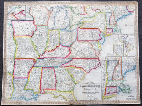
1856 Mitchell Large Antique Pre Civil War Map United States of America California Gold Rush
- Title : Mitchells New Travellers Guide through the United States Showing the Rail Roads, Canals, Stage Roads and c. with Distances from Place to Place. Drawn and engraved by Ira S Drake Philadelphia 1856. Published by Charles Desilver
- Size: 28 3/4in x 22in (730mm x 560mm)
- Condition: (A+) Fine Condition
- Date : 1856
- Ref #: 82034
Description:
This is a large uncommon, beautifully hand coloured and separately issued pre-Civil War original antique map of the United States issued by Charles Desilver in 1856 and is based on the earlier maps by the famous American cartographer, Samuel Augustus Mitchell.
The map covers the United States from the Atlantic seaboard to the western states beyond the Mississippi, with insets maps offering additional detail of the New England states, Lake Superior Copper Mines Region and in the California Gold Mining regions. As to be expected of a map designed for the traveler & explorer, Desilver offers in-depth detail of contemporary railways, canals, and roads with inset maps showing routes to California, illustrating the huge interest in the gold mining of California.
This map was drawn & engraved by Ira Drake and issued first by Desilver in 1856.
General Definitions:
Paper thickness and quality: - Heavy and stable
Paper color : - off white
Age of map color: - Original
Colors used: - Yellow, green, blue, pink
General color appearance: - Authentic
Paper size: - 28 3/4in x 22in (730mm x 560mm)
Plate size: - 28 3/4in x 22in (730mm x 560mm)
Margins: - Min 1/4in (8mm)
Imperfections:
Margins: - None
Plate area: - None
Verso: - None
Background:
Charles Desilver (fl. c. 1850 - 1862) is a little known American map published active in the middle part of the 19th century. Desilver began is cartographic career as a partner in the firm Thomas, Cowperthwait and Company, the publisher of S. A. Mitchell popular New Universal Atlas. In 1856 Desilver acquired Mitchell\'s copyrights and print plates and began to issue his own vaJacques Nicholas Bellinmitriant of the New Universal Atlas. Desilver altered Mitchell\'s maps only slightly; adding a new grillwork border, his own color scheme, new titles, and some updated political data. Despite a noble pedigree, Desilver\'s maps did not sell well - possibly because they followed the long and very popular run of Mitchell\'s own atlases. Desliver continued to publish his atlas until 1859 (though we have heard that he also published an 1862 edition). In 1859 he resold the Mitchell copyrights and printing plates to S. A. Mitchell\'s son S. A. Mitchell Jr. The younger Mitchell again updated the plates with own border and color scheme and began publishing his own successful atlas in 1860.
1868 Wrigley Rare Antique Oilfield Map of Petroleum Centre Area, NW Pennsylvania
- Title : Map of the Oil Belt Southwest from Shamburg and Petroleum Center to Charley Run. Henry E Wrigley Civil Engineer & Surveyor Titusville PA Oct 1868
- Ref #: 93523
- Size: 29 1/2in x 19 1/2in (740mm x 485mm)
- Date : 1868
- Condition: (A) Very Good Condition
Description:
This large original rare lithograph antique oilfield map, one of the first ever published, of the area of Titusville, Oil Creek, Petroleum Centre and Cherrytree in NW Pennsylvania, by Henry Wrigley in 1868 - dated - was published by P S Duval & Sons, Philadelphia.
The map illustrates and names the farms and leases of the area directly related to oil exploration & production.
Petroleum Center is located in Cornplanter Township, Venango County, Pennsylvania, United States.
As the name implies, Petroleum Center was developed during the Pennsylvanian oil rush of the mid-19th century. The first well was drilled on the George Washington McClintock Farm in 1860. Soon a small community grew about half way between Oil City and Titusville. George Henry Bissell, James Bishop and others formed the Central Petroleum Company which owned the farm in the beginning of 1866 when daily production topped 1,000 barrels per day. By the summer of 1866, over 3,000 people called the Centre home with a bank, two churches, a theater, a half-dozen hotels/boarding houses, and stores serving all the needs of the growing community. Bissel & Co. Banking House stimulated economic growth with its direct ties to financial institutions in New York City. President Ulysses S. Grant visited the town in 1871. When a fire devastated the nearby town of Pithole, Pennsylvania, that town's newspaper, the Pithole Daily Record, was relocated to Petroleum Center. The town was founded in 1866 and was essentially abandoned after 1873.
General Definitions:
Paper thickness and quality: - Light and stable
Paper color : - off white
Age of map color: - Original
Colors used: -
General color appearance: -
Paper size: - 29 1/2in x 19 1/2in (740mm x 485mm)
Plate size: - 29 1/2in x 19 1/2in (740mm x 485mm)
Margins: - Min 1/2in (12mm)
Imperfections:
Margins: - Folds as issued
Plate area: - Folds as issued, creasing along folds
Verso: - Folds as issued, several folds re-enforced with archival transparent tape.
Background:
The oil rush in America started in Titusville, Pennsylvania, in the Oil Creek Valley when Edwin L. Drake struck rock oil there in 1859. Titusville and other towns on the shores of Oil Creek expanded rapidly as oil wells and refineries shot up across the region. Oil quickly became one of the most valuable commodities in the United States and railroads expanded into Western Pennsylvania to ship petroleum to the rest of the country.
By the mid-1870s, the oil industry was well established, and the rush to drill wells and control production was over. Pennsylvania oil production peaked in 1891, and was later surpassed by western states such as Texas and California, but some oil industry remains in Pennsylvania.
With petroleum seeps popping up across western Pennsylvania, it became difficult for other extractive industries, especially for salt water wells to extract salt. This business was popular in the area at the time but with oil from the seeps spilling into the wells, it became much more difficult. In 1849 Samuel Kier began extracting oil from the saltwater wells on his property. Upon further examination, Kier recognized that the medicinal oil being prescribed to his wife was the same in chemistry as the oil found in his wells. Kier sold his oil as a remedy and grew wealthy. Other uses for Kiers oil were explored.
In the 1850s Kier began to drill for crude oil rather than separating it from salt water. After extracting the oil from drilling, Kier joined up with John T. Kirkpatrick to build the first refinery. Soon Kier and Kirkpatrick distilled oil that could be used for lighting. For years after, Kier improved the crude oil refining process to produce the cleanest and most efficient lighting oil. He called his oil carbon oil. To accompany his refined oil, Kier invented an oil-burning lamp that burned his oil with little bad odor or smoke. This could have been profitable to Kier, but he never patented his lamp.
News of Kiers experiments spread, and George Bissell, a lawyer from New York, learned of Kiers success. In 1854, Bissell commissioned a study from Yale chemist Benjamin Silliman, Jr. to assess the viability of harvesting oil in western Pennsylvania. After Sillimans results confirmed that the petroleum in the Oil Creek Valley could profitably be distilled into lamp oil, Bissell founded the Pennsylvania Rock Oil Company. The company was funded by businessmen and bankers from New Haven, Connecticut. Among the stockholders was banker James Townsend.
In 1857 Bissell and Townsend hired Edwin Drake to travel to Titusville and drill for crude oil. Drake was an unemployed railroad conductor whose sole qualification for this job seems to have been a free railroad pass that allowed travel to Titusville. Drake secured some land and reported back that he believed the land was oil rich and the oil industry could be extremely profitable. In 1858, the Pennsylvania Rock Oil Company became the Seneca Oil Company with Drake as president.
Soon Drake began drilling for oil in Titusville, near the shores of Oil Creek, but at first met with little success. He used an old steam engine to drill. Many of his drilling sites only yielded trace amounts of oil. He and his assistant, blacksmith Billy Smith, endured fires, financial setbacks, and the ridicule of the local inhabitants. When the Seneca Oil Company gave up and decided to withdraw its funding, Drake obtained a personal line of credit to continue digging. On August 27, 1859, Drake struck oil at 69 feet (21 m) below ground, just before his funds ran out. This marked the beginning of drastic change for the people of Western Pennsylvania. His drilling is considered the first large-scale commercial extraction of petroleum.
Unfortunately for Drake, his success would not last. He had not purchased much land in the region, and the oil industry exploded around him outside of his control. His first well yielded only modest returns and he was fired by Seneca. He never patented the drilling method he pioneered, and lost his modest earnings from the oil business speculating on Wall Street. He would eventually die a poor pensioner in 1880.
Soon the area had many wells drilled by Seneca Oil Company and others. The oil boom in Pennsylvania paralleled in many ways the gold rush in California ten years earlier. It is reported that in the first year (1859), these wells produced 4,500 barrels (720 m3) . Boomtowns such as Titusville, Oil City and Pithole sprang up within years and an early chronicler of the region, Reverend S. J. M. Eaton, observed in 1866 that the Oil Creek Valley was so densely packed it was impossible to distinguish the borders where one town ended and another began. The Titusville population exploded from 250 residents to over 10,000 in little more than five years and in 1866 it incorporated as a city. Ironworks were erected to supply drilling tools and eight oil refineries were built between 1862 and 1868. Pithole expanded from four log-cabin farmhouses to a bustling city with over 50 hotels over the span of five months in 1865.
Annual domestic output of crude swelled from 2,000 barrels (320 m3) in 1859, the year of Drakes discovery, to 4,000,000 barrels (640,000 m3) in 1869 and 10,000,000 barrels (1,600,000 m3) in 1873. The ongoing industrial development of Europe spurred this rapid expansion. European, and especially British, factories began importing large quantities of cheap American oil during the 1860s. By 1866, US petroleum exports far surpassed petroleum distributed to domestic markets and the value of these exports nearly doubled from $16 million in 1865 to $30 million in 1869. Petroleum jumped from the sixth most valuable US export to the second most valuable during this period. At the peak of the oil boom, Pennsylvania wells were producing one third of the worlds oil.
The rush to Pennsylvania created violent swings in the petroleum market for the first decade of the oil boom. In 1861, the proliferation of wells across the Oil Creek Valley pushed the price of oil down from $10 a barrel to 10 cents a barrel. In response, producers in the region formed the Oil Creek Association to restrict output and maintain a minimum price of $4 a barrel. Despite efforts such as this to control the petroleum market, the volatile boom-bust cycle continued into the early 1870s. By 1871, refining capacity had grown to over 12 million barrels per year, more than twice the amount of oil that was actually processed in that year. The first oil exchange in the US was established in Titusville in January 1872 in response to rumors that a conspiratorial ring of crude oil traders in New York City had cornered the market. As the decade progressed, larger producers, such as John D. Rockefellers Standard Oil, began to consolidate their holdings over the wells and refineries in the region, and the oil rush began to settle down.
Pennsylvania oil production peaked in 1891, when the state produced 31 million barrels of oil, 58% of the nations oil that year. But 1892 was the last year that Pennsylvania wells provided a majority of the oil produced in the US, and in 1895, Ohio surpassed Pennsylvania as an oil producer. By 1907, the decline of the Pennsylvania fields and the great discoveries made in Texas, California, and Oklahoma, left Pennsylvania with less than 10% of the nations oil production.
By 1901, the Pennsylvania oil boom was over. The formation of the Standard Oil Trust in 1882 effectively established a monopoly over the industry in Pennsylvania, and the discovery of oil in Texas, California and Wyoming shifted the nations attention elsewhere. Pennsylvania continued to be a significant producer of petroleum for much of the 20th century, but the Oil Creek Valley had been permanently eclipsed.
Please note all items auctioned are genuine, we do not sell reproductions. A Certificate of Authenticity (COA) can be issued on request.
1746 J B D Anville Large Rare Antique Map of North America Pre French Indian War
-
Title : Amerique Septentrionale Publiee sous les Auspices de Monseigneur le Duc d Orleans.. Par Le Snr. D Anville MDCCXLVI
- Ref #: 17010
-
Condition: (A+) Fine Condition
- Size: 42 1/2in x 37in (1.08m x 940mm)
- Date : 1746
Description:
This large important original copper plate engraved antique map of North America, in 12 sheets joined, was engraved in 1746 - dated in the cartouche - and was published by Jean-Baptiste Bourguinon D Anville in his Elephant Folio Atlas Generale.
This map was instrumental in instructing the European Colonial powers of the time, England France & Spain the importance of dominating the New World, that ultimately led to the French and Indian War of 1754–63. This conflict determined the political direction of North America leading to the American War of Independence in 1775 and ultimately the formation of The United States of America.
To illustrate the importance of cartography in the mid eighteenth century, especially that of North America, a J B D Anville map is essential. D Anville dominated 18th century European cartography with many of his cartographical achievements, especially in North America, copied by many of his contemporaries such as Kitchen, Sayer, Homann, Seutter, Mitchell and others .
He was one of the first to leave blank spaces in his maps, where knowledge was scant or insufficient. His representation of the great lakes is superior to that of his contemporary John Mitchell, responsible for publishing one of the most famous mid 18th century maps of North America, A Map of the British and French Dominions in North America on 8 sheets in 1755 and remained the standard map of North America up until the end of the 18th century. (Ref: Tooley, Printed maps of America, 104; The Mapping of America 316)
General Definitions:
Paper thickness and quality: - Heavy and stable
Paper color : - off white
Age of map color: - Original
Colors used: - Red, yellow, green, blue
General color appearance: - Authentic
Paper size: - 42 1/2in x 37in (1.08m x 940mm)
Plate size: - 34 1/2in x 33 1/2in (875m x 850mm)
Margins: - Min 1in (25mm)
Imperfections:
Margins: - Small wormholes in left margin repaired, not affecting the image
Plate area: - Light age toning
Verso: - Age toning
Background:
The French and Indian War (1754–63) comprised the North American theatre of the worldwide Seven Years War of 1756–63. It pitted the colonies of British America against those of New France. Both sides were supported by military units from their parent countries, as well as by American Indian allies. At the start of the war, the French North American colonies had a population of roughly 60,000 settlers, compared with 2 million in the British North American colonies. The outnumbered French particularly depended on the Indians. The European nations declared war on one another in 1756 following months of localized conflict, escalating the war from a regional affair into an intercontinental conflict.
The name French and Indian War is used mainly in the United States. It refers to the two enemies of the British colonists, the royal French forces and their various American Indian allies. The British colonists were supported at various times by the Iroquois, Catawba, and Cherokee, and the French colonists were supported by Wabanaki Confederacy members Abenaki and Mikmaq, and Algonquin, Lenape, Ojibwa, Ottawa, Shawnee, and Wyandot.
British and other European historians use the term the Seven Years War, as do English-speaking Canadians. French Canadians call it La guerre de la Conquête (the War of the Conquest) or (rarely) the Fourth Intercolonial War.
Fighting took place primarily along the frontiers between New France and the British colonies, from Virginia in the south to Newfoundland in the north. It began with a dispute over control of the confluence of the Allegheny River and Monongahela River called the Forks of the Ohio, and the site of the French Fort Duquesne in Pittsburgh, Pennsylvania. The dispute erupted into violence in the Battle of Jumonville Glen in May 1754, during which Virginia militiamen under the command of 22-year-old George Washington ambushed a French patrol.
In 1755, six colonial governors in North America met with General Edward Braddock, the newly arrived British Army commander, and planned a four-way attack on the French. None succeeded, and the main effort by Braddock proved a disaster; he lost the Battle of the Monongahela on July 9, 1755 and died a few days later. British operations failed in the frontier areas of Pennsylvania and New York during 1755–57 due to a combination of poor management, internal divisions, effective Canadian scouts, French regular forces, and Indian warrior allies. In 1755, the British captured Fort Beauséjour on the border separating Nova Scotia from Acadia, and they ordered the expulsion of the Acadians (1755–64) soon afterwards. Orders for the deportation were given by William Shirley, Commander-in-Chief, North America, without direction from Great Britain. The Acadians were expelled, both those captured in arms and those who had sworn the loyalty oath to His Britannic Majesty. Indians likewise were driven off the land to make way for settlers from New England.
The British colonial government fell in the region of modern Nova Scotia after several disastrous campaigns in 1757, including a failed expedition against Louisbourg and the Siege of Fort William Henry; this last was followed by Indians torturing and massacring their British victims. William Pitt came to power and significantly increased British military resources in the colonies at a time when France was unwilling to risk large convoys to aid the limited forces that they had in New France, preferring to concentrate their forces against Prussia and its allies in the European theater of the war. Between 1758 and 1760, the British military launched a campaign to capture the Colony of Canada (part of New France). They succeeded in capturing territory in surrounding colonies and ultimately the city of Quebec (1759). The British later lost the Battle of Sainte-Foy west of Quebec (1760), but the French ceded Canada in accordance with the Treaty of Paris (1763).
The outcome was one of the most significant developments in a century of Anglo-French conflict. France ceded to Great Britain its territory east of the Mississippi. It ceded French Louisiana west of the Mississippi River (including New Orleans) to its ally Spain in compensation for Spains loss to Britain of Florida. (Spain had ceded Florida to Britain in exchange for the return of Havana, Cuba.) Frances colonial presence north of the Caribbean was reduced to the islands of Saint Pierre and Miquelon, confirming Great Britains position as the dominant colonial power in eastern North America.
Please note all items auctioned are genuine, we do not sell reproductions. A Certificate of Authenticity (COA) can be issued on request.
1756 Homann Antique Map Colonial United States North America French Indian War
- Title : America Septentrionalis a domino d Anville in Galiis edita nunc in Anglia coloniis in interiorem Virginiam deductis nec non fluvii Ohio cursu aucta notisq geographicis et historicis illustrata.....1756
- Ref #: 17001
- Size: 21in x 19in (535mm x 480mm)
- Date : 1756
- Condition: (A) Very Good Condition
Description:
This original hand coloured copper-plate engraved antique 1st edition map of the Colonial United States, at the beginning of the French-Indian war, was engraved in 1756 - dated in cartouche - by the Homann firm, Germany.
First edition Homann map of the English Colonies in North America prior to the start of the French and Indian War. The map stretches just west of the Mississippi River to the east and from James Bay through the Great Lakes to the Gulf of Mexico. Although most of the text is in German, there is also much in English, including numerous place named annotations associated the French and Indian War, such as the locations of Fort Duquesne and Fort Necessity, both taken by the French in 1754. Thus although the cartographer credits D Anville for the basic cartography, it is clear he is drawing from English, not French, sources. Bottom right and upper left are notes offering the history of North America.
General Definitions:
Paper thickness and quality: - Heavy and stable
Paper color : - off white
Age of map color: - Original & later
Colors used: - Yellow, green, blue, pink
General color appearance: - Authentic
Paper size: - 21in x 19in (535mm x 480mm)
Plate size: - 21in x 19in (535mm x 480mm)
Margins: - Min 1/2in (12mm)
Imperfections:
Margins: - All margins extended from border
Plate area: - Light crease adjacent to centerfold, soiling in top right border
Verso: - Light soiling.
Background:
The French and Indian War (1754–63) comprised the North American theatre of the worldwide Seven Years War of 1756–63. It pitted the colonies of British America against those of New France. Both sides were supported by military units from their parent countries, as well as by American Indian allies. At the start of the war, the French North American colonies had a population of roughly 60,000 settlers, compared with 2 million in the British North American colonies. The outnumbered French particularly depended on the Indians. The European nations declared war on one another in 1756 following months of localized conflict, escalating the war from a regional affair into an intercontinental conflict.
The name French and Indian War is used mainly in the United States. It refers to the two enemies of the British colonists, the royal French forces and their various American Indian allies. The British colonists were supported at various times by the Iroquois, Catawba, and Cherokee, and the French colonists were supported by Wabanaki Confederacy members Abenaki and Mikmaq, and Algonquin, Lenape, Ojibwa, Ottawa, Shawnee, and Wyandot.
British and other European historians use the term the Seven Years War, as do English-speaking Canadians. French Canadians call it La guerre de la Conquête (the War of the Conquest) or (rarely) the Fourth Intercolonial War.
Fighting took place primarily along the frontiers between New France and the British colonies, from Virginia in the south to Newfoundland in the north. It began with a dispute over control of the confluence of the Allegheny River and Monongahela River called the Forks of the Ohio, and the site of the French Fort Duquesne in Pittsburgh, Pennsylvania. The dispute erupted into violence in the Battle of Jumonville Glen in May 1754, during which Virginia militiamen under the command of 22-year-old George Washington ambushed a French patrol.
In 1755, six colonial governors in North America met with General Edward Braddock, the newly arrived British Army commander, and planned a four-way attack on the French. None succeeded, and the main effort by Braddock proved a disaster; he lost the Battle of the Monongahela on July 9, 1755 and died a few days later. British operations failed in the frontier areas of Pennsylvania and New York during 1755–57 due to a combination of poor management, internal divisions, effective Canadian scouts, French regular forces, and Indian warrior allies. In 1755, the British captured Fort Beauséjour on the border separating Nova Scotia from Acadia, and they ordered the expulsion of the Acadians (1755–64) soon afterwards. Orders for the deportation were given by William Shirley, Commander-in-Chief, North America, without direction from Great Britain. The Acadians were expelled, both those captured in arms and those who had sworn the loyalty oath to His Britannic Majesty. Indians likewise were driven off the land to make way for settlers from New England.
The British colonial government fell in the region of modern Nova Scotia after several disastrous campaigns in 1757, including a failed expedition against Louisbourg and the Siege of Fort William Henry; this last was followed by Indians torturing and massacring their British victims. William Pitt came to power and significantly increased British military resources in the colonies at a time when France was unwilling to risk large convoys to aid the limited forces that they had in New France, preferring to concentrate their forces against Prussia and its allies in the European theater of the war. Between 1758 and 1760, the British military launched a campaign to capture the Colony of Canada (part of New France). They succeeded in capturing territory in surrounding colonies and ultimately the city of Quebec (1759). The British later lost the Battle of Sainte-Foy west of Quebec (1760), but the French ceded Canada in accordance with the Treaty of Paris (1763).
The outcome was one of the most significant developments in a century of Anglo-French conflict. France ceded to Great Britain its territory east of the Mississippi. It ceded French Louisiana west of the Mississippi River (including New Orleans) to its ally Spain in compensation for Spains loss to Britain of Florida. (Spain had ceded Florida to Britain in exchange for the return of Havana, Cuba.) Frances colonial presence north of the Caribbean was reduced to the islands of Saint Pierre and Miquelon, confirming Great Britains position as the dominant colonial power in eastern North America.
Please note all items auctioned are genuine, we do not sell reproductions. A Certificate of Authenticity (COA) can be issued on request.
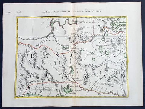
1778 Antonio Zatta & John Mitchell Antique Map of East Quebec & Western Ontario
- Title : La Parte Occidentale Della Nuova Francia o Canada
- Date : 1778
- Condition: (A+) Fine Condition
- Ref: 93512
- Size: 21in x 15 1/2in (535mm x 395mm)
Description:
Description:
This wonderfully executed original copper plate engraved hand coloured antique map of eastern Quebec and Western Ontario - from Lake Superior in the west to Montreal in the east and Hudson Bay in the North was published as Sheet 2, of 12, of Antonio Zattas 1778 re-issue of John Mitchells famous landmark map A Map of the British and French Dominions in North America, With the Roads, Distances, Limits, and Extent of the Settlements was published in Zattas Atlas Atlante Novissimo (1779-1785)
I have included an image of the complete 12 sheet joined map by Zatta as well as an image of Mitchells map.
General Definitions:
Paper thickness and quality: - Heavy and stable
Paper color : - off white
Age of map color: - Original
Colors used: - Yellow, green, blue, pink
General color appearance: - Authentic
Paper size: - 21in x 15 1/2in (535mm x 395mm)
Plate size: - 17 1/2in x 13 1/2in (445mm x 345mm)
Margins: - Min 1in (25mm)
Imperfections:
Margins: - None
Plate area: - None
Verso: - None
Background:
The Mitchell Map by John Mitchell (1711–1768) is considered the most famous map of North America both cartographically and historically, was reprinted several times during the second half of the 18th century. The Mitchell Map was used as a primary map source during the Treaty of Paris for defining the boundaries of the newly independent United States. The map remained important for resolving border disputes between the United States and Canada as recently as the 1980s dispute over the Gulf of Maine fisheries. The Mitchell Map is the most comprehensive map of eastern North America made during the colonial era. Its size is about 6.5 feet (2.0 m) wide by 4.5 feet (1.4 m) high.
John Mitchell was not a professional geographer or map-maker. Son of a wealthy Virginian family in Lancaster County, on Virginia's Northern Neck, he had been educated at Edinburgh University, Scotland; this education included the first two years of the three-year medical program. Returning to coastal Virginia, he practiced as a physician and studied the local botany. Ill health forced Mitchell and his wife to leave Virginia for London in 1746. There, he served as a consultant on exotic plants to noblemen interested in gardens. Also, it was there that Mitchell would make his famous map. Map historians have understandably been interested in why a physician and botanist who had shown no previous interest in map making should make such a large and detailed map.
Until recently, historians have argued that Mitchell was upset by the lack of interest shown by politicians in London about colonial affairs and so set out to warn them about the dangers posed to the British colonies by the French. Mitchell did so, on his own initiative, by making a first map of North America in 1750, which he then showed to the politicians he knew through his botanical and gardening activities. The map so impressed George Montagu-Dunk, 2nd Earl of Halifax, appointed president of the Board of Trade and Plantations in 1748, that Halifax opened up the official archives and solicited new maps from the colonies for Mitchell to make a new and better map. This was the map published in 1755. That is, the motive force for preparations against the French threat is understood to have come from a colonist who sought to take control of the colonies' future on behalf of the other colonists.
A re-examination of the archival evidence indicates, however, that Mitchell made his first map in 1750 at Halifax's behest. Halifax became president of the Board of Trade directly after the conclusion of the War of the Austrian Succession (1744–1748) and its North American component, King George's War. The war had ended in stalemate and a return to the Anglo-French status quo of the 1714 Treaty of Utrecht. In fact, it was a common conviction that it was only a matter of time before another global Anglo-French war would begin, and it was commonly expected that the spark of the new conflict would be the North American colonies. It was then that Halifax latched onto Mitchell as an expert informant on all things colonial; one of his requests, apparently, was for Mitchell to make a new map to show the territorial situation in North America. Certainly, it was only after 1749 that Mitchell's correspondence revealed his new interests in both geography and politics.
Mitchell compiled a first map in 1750 from the materials that he could find in London, in official archives and private hands. It proved to be inadequate. Halifax accordingly ordered the governors of the British colonies to send new maps, which most did. These became the basis, when fitted into the overall geographical frame provided by the maps of the French geographer Guillaume Delisle. Late in 1754, Halifax was using one manuscript copy of Mitchell's second map to successfully promote his political position (no compromise with the French) within the British cabinet in the build-up to the Seven Years' War aka French and Indian War. Halifax also permitted Mitchell to have the map published: it appeared in April 1755, engraved by Thomas Kitchin and published by Andrew Millar.
The published map bore the title A Map of the British and French Dominions in North America. It bore the copyright date of 13 February 1755, but the map was probably not sold to the public until April or even May. Minor corrections to the map's printing plates were made probably during the printing process.
The geographer John Green (né Braddock Mead) criticized Mitchell and his map soon after it appeared, emphasizing two failings with respect to Nova Scotia (an area of particular dispute with the French). Mitchell, Green noted, had used neither the astronomical observations for latitude and longitude made by Marquis Joseph Bernard de Chabert in the 1740s nor a 1715 chart of the Nova Scotia coast. In response, Mitchell released a new version of his map, now with two large blocks of text that described all of his data sources; the new version of the map also adjusted the coastline in line with Chabert's work but rejected the 1715 chart as deeply flawed. This version of the map, which Mitchell referred to as the "second edition," is commonly thought to have appeared sometime in 1757, but advertisements in the (London) Public Advertiser and Gazetteer and London Daily Advertiser on 23 April 1756 clearly indicate that this new map appeared at that time.
The map continued to be corrected and some boundaries updated, even after Mitchell's death in 1768.
Mitchell's map was printed in eight sheets; when assembled, it measures 136 cm by 195 cm (4 feet 6 inches by 6 feet 5 inches; height x width). The initial impressions printed in 1755 have a consistent coloring outlining British colonial claims. Mitchell extended the southern colonies across the entire continent, even over established Spanish territory west of the Mississippi. Mitchell divided up the Iroquois territories (as he understood them, reaching from Lake Champlain [Lac Irocoisia] to the Mississippi, and north of Lake Superior) between Virginia and New York, leaving only a much-reduced territory to the French.
Mitchell's map was expensive but it spawned many cheaper variants that trumpeted Halifax and Mitchell's powerful colonial vision to the British public. One of these, published in December 1755 by "a Society of Anti-Gallicans", restricted the French even further just to Quebec.
The map is liberally sprinkled with text describing and explaining various features, especially in regions that were relatively unknown or which were subject to political dispute. Many notes describe the natural resources and potential for settlement of frontier regions. Others describe Indian tribes. Many Indian settlements are shown, along with important Indian trails.
Since Mitchell's main objective was to show the French threat to the British colonies, there is a very strong pro-British bias in the map, especially with regard to the Iroquois. The map makes clear that the Iroquois were not just allies of Britain, but subjects, and that all Iroquois land was therefore British territory. Huge parts of the continent are noted as being British due to Iroquois conquest of one tribe or another. French activity within the Iroquois claimed lands is noted, explicitly or implicitly, as illegal.
In cases where the imperial claims of Britain and France were questionable, Mitchell always takes the British side. Thus many of his notes and boundaries seem like political propaganda today. Some of the claims seem to be outright falsehoods.
The map is very large and the notes are often very small, making it difficult to view online. Reduced scale copies result in unreadable notes. The following list gives a few examples of the kind of notes found on the map, with Mitchell's spelling:
- The region of today's central Tennessee and Kentucky (between the Tennessee and Cumberland Rivers): A Fine Level Fertile Country of great Extent, by Accounts of the Indians and our People
- In the area between the Mississippi River and the Tennessee River: This Country of the Cherokees which extends Westward to the Mississippi and Northward to the Confines of the Six Nations was formally surrendered to the Crown of Britain at Westminster 1729
- In the Great Plains: The Nadouessoians are reckoned one of the most Populous Nations of Indians in North America, altho' the number and situation of their Villages are not known nor laid down. (Reference to the Sioux)
- Along the coast of the Gulf of Mexico, present-day Texas: Wandering Savage Indians
- Southwest of Hudson Bay: The long and Barbarous Names lately given to some of these Northern Parts of Canada and the Lakes we have not inserted, as they are of no use, and uncertain Authority.
- North of Lake Huron: MESSESAGUES—Subdued by the Iroquois and now united with them making the 8th Nation in that League. (reference to the Mississaugas)
- Missouri River: Missouri River is reckoned to run Westward to the Mountains of New Mexico, as far as the Ohio does Eastward
- Present-day Iowa: Extensive Meadows full of Buffaloes
- Sandusky, Ohio: Sandoski—Canahogue—The seat of War, the Mart of Trade, & chief Hunting Grounds of the Six Nations, on the Lakes & the Ohio.
- Central Pennsylvania, north of present-day Harrisburg: St. Anthony's Wilderness
- Illinois region: The Antient Eriez were extirpated by the Iroquois upwards of 100 years ago, ever since which time they have been in Possession of L. Erie (reference to the Erie people)
- Along Illinois River and overland to the south end of Lake Michigan: Western Bounds of the Six Nations sold and Surrendered to Great Britain
- Illinois region: The Six Nations have extended their Territories to the River Illinois, ever since the Year 1672, when they subdued, and were incorporated with, the Antient Chaouanons, the Native Proprietors of these Countries, and the River Ohio. Besides which they likewise claim a Right of Conquest over the Illinois, and all the Mississippi as far as they extend. This is confirmed by their own Claims and Possessions in 1742, which include all the Bounds here laid down, and none have ever thought fit to dispute them. (reference to the Illiniwek)
- Just below the previous note: The Ohio Indians are a mixt Tribe of the Several Indians of our Colonies, settled here under the Six Nations, who have always been in Alliance and Subjection to the English. The most numerous of them are the Delaware and Shawnoes, who are Natives of Delaware River. Those about Philadelphia were called Sauwanoos whom we now call Shawanoes, or Shawnoes. The Mohickans and Minquaas were the Antient Inhabitants of Susquehanna R. (reference to the Lenape, Shawnee, and Susquehannock Indians)
- Southeast Missouri area: Mines of Marameg, which gave rise to the famous Mississippi Scheme 1719.
- North Florida: TIMOOQUA—Destroy'd by the Carolinians in 1706 (reference to the Timucua)
- South Georgia: COUNTRY OF THE APALACHEES—Conquered & surrendered to the Carolinians, after two memorable Victories obtain'd over them & the Spaniards in 1702 & 1703 at the Places marked thus [crossed-swords] (reference to the Apalachee)
- Alabama area: The English have Factories & Settlements in all the Towns of the Creek Indians of any note, except Albamas; which was usurped by the French in 1715 but established by the English 28 years before. (reference to the Creek people)
- Yazoo River: River of the Yasous—The Indians on this River were in Alliance with the English, for which they have been destroyed by the French (reference to the Yazoo tribe)
- Many geographic features are labeled with names no longer in use or oddly spelled, including:
Des Moines River: Moingona River
Kanawha and New River together: Gr. Conhaway called Wood R. or New R.
Kentucky River: Cuttawa or Catawba R.
Clinch River: Pelisipi River (a tributary is labeled Clinch's R.)
Tennessee River: River of the Cherakees, or Hogohegee R. Upstream another label says River Hogohegee or Callamaco
French Broad River: Agiqua R.
Little Tennessee River: Tannaſsee or Satico R.
Hiwassee River: Euphasee
Ohio River: Ohio or Splawacipiki R.
Altamaha River: Alatamaha or George R.
Minnesota River: Ouadebameniſsouté or R. St. Peter (reflecting the Dakota name Watpá Mnísota and the French name Rivière de St. Pierre)
Muskegon River: Maticon R.
The map also included non-existent features, such as Isle Phelipeaux in Lake Superior, found in earlier maps by Jacques-Nicolas Bellin.
The Mitchell Map remained the most detailed map of North America available in the later eighteenth century. Various impressions (and also French copies) were used to establish the boundaries of the new United States of America by diplomats at the 1783 Treaty of Paris that ended the American Revolutionary War. The map's inaccuracies subsequently led to a number of border disputes, such as in Maine. Its supposition that the Mississippi River extended north to the 50th parallel (into British territory) resulted in the treaty using it as a landmark for a geographically impossible definition of the border in that region. It was not until 1842, when the Webster-Ashburton Treaty resolved these inconsistencies with fixes such as the one that created Minnesota's Northwest Angle, that the U.S.–Canada border was clearly drawn from Maine to the Oregon Country.
Similarly, during the drafting of the Northwest Ordinance, the map's inaccuracy in depicting where an east–west line drawn through the southernmost point of Lake Michigan would intersect Lake Erie led to a long dispute over the Ohio–Michigan border that culminated in the Toledo War.
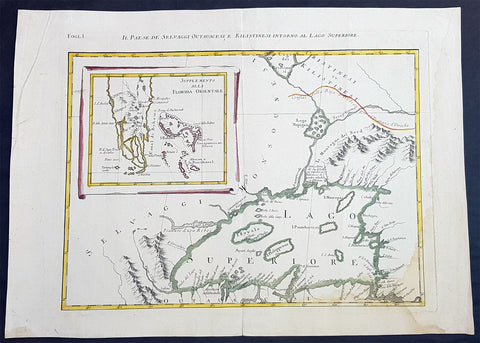
1778 Antonio Zatta & John Mitchell Antique Map of Lake Superior & Florida
- Title : Il Paese de Selvaggi Outauace si e Kilistinesi Intorno Al Lago Superiore; Supplemento alla Florida Orientale
- Date : 1778
- Condition: (A+) Fine Condition
- Ref: 93517
- Size: 21in x 15 1/2in (535mm x 395mm)
Description:
This wonderfully executed original copper plate engraved hand coloured antique map of Lake Superior, with an inset map of southern Florida, was published as Sheet 1, of 12, of Antonio Zattas 1778 re-issue of John Mitchells famous landmark map A Map of the British and French Dominions in North America, With the Roads, Distances, Limits, and Extent of the Settlements was published in Zattas Atlas Atlante Novissimo (1779-1785)
I have included an image of the complete 12 sheet joined map by Zatta as well as an image of Mitchells map.
General Definitions:
Paper thickness and quality: - Heavy and stable
Paper color : - off white
Age of map color: - Original
Colors used: - Yellow, green, blue, pink
General color appearance: - Authentic
Paper size: - 21in x 15 1/2in (535mm x 395mm)
Plate size: - 17 1/2in x 13 1/2in (445mm x 345mm)
Margins: - Min 1in (25mm)
Imperfections:
Margins: - None
Plate area: - None
Verso: - None
Background:
The Mitchell Map by John Mitchell (1711–1768) is considered the most famous map of North America both cartographically and historically, was reprinted several times during the second half of the 18th century. The Mitchell Map was used as a primary map source during the Treaty of Paris for defining the boundaries of the newly independent United States. The map remained important for resolving border disputes between the United States and Canada as recently as the 1980s dispute over the Gulf of Maine fisheries. The Mitchell Map is the most comprehensive map of eastern North America made during the colonial era. Its size is about 6.5 feet (2.0 m) wide by 4.5 feet (1.4 m) high.
John Mitchell was not a professional geographer or map-maker. Son of a wealthy Virginian family in Lancaster County, on Virginia's Northern Neck, he had been educated at Edinburgh University, Scotland; this education included the first two years of the three-year medical program. Returning to coastal Virginia, he practiced as a physician and studied the local botany. Ill health forced Mitchell and his wife to leave Virginia for London in 1746. There, he served as a consultant on exotic plants to noblemen interested in gardens. Also, it was there that Mitchell would make his famous map. Map historians have understandably been interested in why a physician and botanist who had shown no previous interest in map making should make such a large and detailed map.
Until recently, historians have argued that Mitchell was upset by the lack of interest shown by politicians in London about colonial affairs and so set out to warn them about the dangers posed to the British colonies by the French. Mitchell did so, on his own initiative, by making a first map of North America in 1750, which he then showed to the politicians he knew through his botanical and gardening activities. The map so impressed George Montagu-Dunk, 2nd Earl of Halifax, appointed president of the Board of Trade and Plantations in 1748, that Halifax opened up the official archives and solicited new maps from the colonies for Mitchell to make a new and better map. This was the map published in 1755. That is, the motive force for preparations against the French threat is understood to have come from a colonist who sought to take control of the colonies' future on behalf of the other colonists.
A re-examination of the archival evidence indicates, however, that Mitchell made his first map in 1750 at Halifax's behest. Halifax became president of the Board of Trade directly after the conclusion of the War of the Austrian Succession (1744–1748) and its North American component, King George's War. The war had ended in stalemate and a return to the Anglo-French status quo of the 1714 Treaty of Utrecht. In fact, it was a common conviction that it was only a matter of time before another global Anglo-French war would begin, and it was commonly expected that the spark of the new conflict would be the North American colonies. It was then that Halifax latched onto Mitchell as an expert informant on all things colonial; one of his requests, apparently, was for Mitchell to make a new map to show the territorial situation in North America. Certainly, it was only after 1749 that Mitchell's correspondence revealed his new interests in both geography and politics.
Mitchell compiled a first map in 1750 from the materials that he could find in London, in official archives and private hands. It proved to be inadequate. Halifax accordingly ordered the governors of the British colonies to send new maps, which most did. These became the basis, when fitted into the overall geographical frame provided by the maps of the French geographer Guillaume Delisle. Late in 1754, Halifax was using one manuscript copy of Mitchell's second map to successfully promote his political position (no compromise with the French) within the British cabinet in the build-up to the Seven Years' War aka French and Indian War. Halifax also permitted Mitchell to have the map published: it appeared in April 1755, engraved by Thomas Kitchin and published by Andrew Millar.
The published map bore the title A Map of the British and French Dominions in North America. It bore the copyright date of 13 February 1755, but the map was probably not sold to the public until April or even May. Minor corrections to the map's printing plates were made probably during the printing process.
The geographer John Green (né Braddock Mead) criticized Mitchell and his map soon after it appeared, emphasizing two failings with respect to Nova Scotia (an area of particular dispute with the French). Mitchell, Green noted, had used neither the astronomical observations for latitude and longitude made by Marquis Joseph Bernard de Chabert in the 1740s nor a 1715 chart of the Nova Scotia coast. In response, Mitchell released a new version of his map, now with two large blocks of text that described all of his data sources; the new version of the map also adjusted the coastline in line with Chabert's work but rejected the 1715 chart as deeply flawed. This version of the map, which Mitchell referred to as the "second edition," is commonly thought to have appeared sometime in 1757, but advertisements in the (London) Public Advertiser and Gazetteer and London Daily Advertiser on 23 April 1756 clearly indicate that this new map appeared at that time.
The map continued to be corrected and some boundaries updated, even after Mitchell's death in 1768.
Mitchell's map was printed in eight sheets; when assembled, it measures 136 cm by 195 cm (4 feet 6 inches by 6 feet 5 inches; height x width). The initial impressions printed in 1755 have a consistent coloring outlining British colonial claims. Mitchell extended the southern colonies across the entire continent, even over established Spanish territory west of the Mississippi. Mitchell divided up the Iroquois territories (as he understood them, reaching from Lake Champlain [Lac Irocoisia] to the Mississippi, and north of Lake Superior) between Virginia and New York, leaving only a much-reduced territory to the French.
Mitchell's map was expensive but it spawned many cheaper variants that trumpeted Halifax and Mitchell's powerful colonial vision to the British public. One of these, published in December 1755 by "a Society of Anti-Gallicans", restricted the French even further just to Quebec.
The map is liberally sprinkled with text describing and explaining various features, especially in regions that were relatively unknown or which were subject to political dispute. Many notes describe the natural resources and potential for settlement of frontier regions. Others describe Indian tribes. Many Indian settlements are shown, along with important Indian trails.
Since Mitchell's main objective was to show the French threat to the British colonies, there is a very strong pro-British bias in the map, especially with regard to the Iroquois. The map makes clear that the Iroquois were not just allies of Britain, but subjects, and that all Iroquois land was therefore British territory. Huge parts of the continent are noted as being British due to Iroquois conquest of one tribe or another. French activity within the Iroquois claimed lands is noted, explicitly or implicitly, as illegal.
In cases where the imperial claims of Britain and France were questionable, Mitchell always takes the British side. Thus many of his notes and boundaries seem like political propaganda today. Some of the claims seem to be outright falsehoods.
The map is very large and the notes are often very small, making it difficult to view online. Reduced scale copies result in unreadable notes. The following list gives a few examples of the kind of notes found on the map, with Mitchell's spelling:
- The region of today's central Tennessee and Kentucky (between the Tennessee and Cumberland Rivers): A Fine Level Fertile Country of great Extent, by Accounts of the Indians and our People
- In the area between the Mississippi River and the Tennessee River: This Country of the Cherokees which extends Westward to the Mississippi and Northward to the Confines of the Six Nations was formally surrendered to the Crown of Britain at Westminster 1729
- In the Great Plains: The Nadouessoians are reckoned one of the most Populous Nations of Indians in North America, altho' the number and situation of their Villages are not known nor laid down. (Reference to the Sioux)
- Along the coast of the Gulf of Mexico, present-day Texas: Wandering Savage Indians
- Southwest of Hudson Bay: The long and Barbarous Names lately given to some of these Northern Parts of Canada and the Lakes we have not inserted, as they are of no use, and uncertain Authority.
- North of Lake Huron: MESSESAGUES—Subdued by the Iroquois and now united with them making the 8th Nation in that League. (reference to the Mississaugas)
- Missouri River: Missouri River is reckoned to run Westward to the Mountains of New Mexico, as far as the Ohio does Eastward
- Present-day Iowa: Extensive Meadows full of Buffaloes
- Sandusky, Ohio: Sandoski—Canahogue—The seat of War, the Mart of Trade, & chief Hunting Grounds of the Six Nations, on the Lakes & the Ohio.
- Central Pennsylvania, north of present-day Harrisburg: St. Anthony's Wilderness
- Illinois region: The Antient Eriez were extirpated by the Iroquois upwards of 100 years ago, ever since which time they have been in Possession of L. Erie (reference to the Erie people)
- Along Illinois River and overland to the south end of Lake Michigan: Western Bounds of the Six Nations sold and Surrendered to Great Britain
- Illinois region: The Six Nations have extended their Territories to the River Illinois, ever since the Year 1672, when they subdued, and were incorporated with, the Antient Chaouanons, the Native Proprietors of these Countries, and the River Ohio. Besides which they likewise claim a Right of Conquest over the Illinois, and all the Mississippi as far as they extend. This is confirmed by their own Claims and Possessions in 1742, which include all the Bounds here laid down, and none have ever thought fit to dispute them. (reference to the Illiniwek)
- Just below the previous note: The Ohio Indians are a mixt Tribe of the Several Indians of our Colonies, settled here under the Six Nations, who have always been in Alliance and Subjection to the English. The most numerous of them are the Delaware and Shawnoes, who are Natives of Delaware River. Those about Philadelphia were called Sauwanoos whom we now call Shawanoes, or Shawnoes. The Mohickans and Minquaas were the Antient Inhabitants of Susquehanna R. (reference to the Lenape, Shawnee, and Susquehannock Indians)
- Southeast Missouri area: Mines of Marameg, which gave rise to the famous Mississippi Scheme 1719.
- North Florida: TIMOOQUA—Destroy'd by the Carolinians in 1706 (reference to the Timucua)
- South Georgia: COUNTRY OF THE APALACHEES—Conquered & surrendered to the Carolinians, after two memorable Victories obtain'd over them & the Spaniards in 1702 & 1703 at the Places marked thus [crossed-swords] (reference to the Apalachee)
- Alabama area: The English have Factories & Settlements in all the Towns of the Creek Indians of any note, except Albamas; which was usurped by the French in 1715 but established by the English 28 years before. (reference to the Creek people)
- Yazoo River: River of the Yasous—The Indians on this River were in Alliance with the English, for which they have been destroyed by the French (reference to the Yazoo tribe)
- Many geographic features are labeled with names no longer in use or oddly spelled, including:
Des Moines River: Moingona River
Kanawha and New River together: Gr. Conhaway called Wood R. or New R.
Kentucky River: Cuttawa or Catawba R.
Clinch River: Pelisipi River (a tributary is labeled Clinch's R.)
Tennessee River: River of the Cherakees, or Hogohegee R. Upstream another label says River Hogohegee or Callamaco
French Broad River: Agiqua R.
Little Tennessee River: Tannaſsee or Satico R.
Hiwassee River: Euphasee
Ohio River: Ohio or Splawacipiki R.
Altamaha River: Alatamaha or George R.
Minnesota River: Ouadebameniſsouté or R. St. Peter (reflecting the Dakota name Watpá Mnísota and the French name Rivière de St. Pierre)
Muskegon River: Maticon R.
The map also included non-existent features, such as Isle Phelipeaux in Lake Superior, found in earlier maps by Jacques-Nicolas Bellin.
The Mitchell Map remained the most detailed map of North America available in the later eighteenth century. Various impressions (and also French copies) were used to establish the boundaries of the new United States of America by diplomats at the 1783 Treaty of Paris that ended the American Revolutionary War. The map's inaccuracies subsequently led to a number of border disputes, such as in Maine. Its supposition that the Mississippi River extended north to the 50th parallel (into British territory) resulted in the treaty using it as a landmark for a geographically impossible definition of the border in that region. It was not until 1842, when the Webster-Ashburton Treaty resolved these inconsistencies with fixes such as the one that created Minnesota's Northwest Angle, that the U.S.–Canada border was clearly drawn from Maine to the Oregon Country.
Similarly, during the drafting of the Northwest Ordinance, the map's inaccuracy in depicting where an east–west line drawn through the southernmost point of Lake Michigan would intersect Lake Erie led to a long dispute over the Ohio–Michigan border that culminated in the Toledo War.
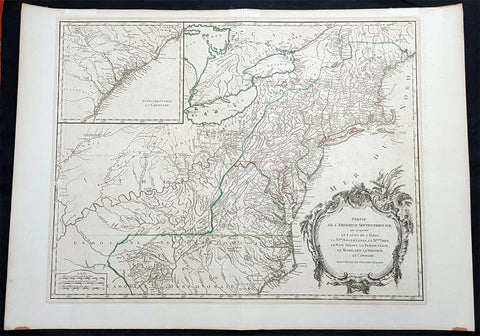
1768 Robert De Vaugondy Large Antique 2nd edition Map of Colonial United States
- Title : Partie De L Amerique Septentrionale, qui Comprend Le Cours De L Ohio...Par le Sr Robert de Vaugondy
- Date : 1768
- Condition: (A+) Fine Condition
- Ref: 93504
- Size: 30in x 21in (760mm x 550mm)
Description:
This large original beautifully hand coloured, scarce 2nd edition antique map of the east coast of the United States, illustrating the course of the Ohio River and stretching from New England to the Carolinas, north to the Great Lakes and south to the Mississippi - with an inset map of The Carolinas - was published in 1768 by Robert Du Vaugondy in his Atlas Universal.
This is one of the best examples of this map I have seen, beautiful hand colour on age toned heavy paper with original margins with a heavy dark ink denoting an early pressing.
General Definitions:
Paper thickness and quality: - Heavy and stable
Paper color : - off white
Age of map color: - Original & later
Colors used: - Yellow, green, blue, pink
General color appearance: - Authentic
Paper size: - 30in x 22in (760mm x 560mm)
Plate size: - 25in x 19 1/2in (635mm x 495mm)
Margins: - Min 1in (25mm)
Imperfections:
Margins: - None
Plate area: - None
Verso: - None
Background:
Second state of the early de Vaugondy map of the British colonies, with changes after the 1763 Treaty of Paris, with Virginia & Carolina extended to the Mississippi and Pennsylvania extended to Lake Erie. The majority of geographical information is based upon John Mitchells great map of North America from the mid 1750s, also drawing from Lewis, Evans on the Middle British Colonies and Joshua Frys and Peter Jeffersons map of Virginia and Maryland. The Mitchell map was the culmination of many years of British surveying in the North American Colonies and was considered one of the best maps of the continent available to Europeans and Americans in the mid-eighteenth century.
De Vaugondys rendition does not copy the full scope of Mitchells map but instead focuses on the colonies stretching from southern Maine to the Carolinas. In the top left corner is an inset of South Carolina and Georgia. De Vaugondy also pays special attention to the river systems and settlements. This map shows some of the earliest accurate information of the trans-Allegheny regions (the Ohio River, Kentucky, Tennessee and Parts of Ohio) and inland areas to the southeast of the Great Lakes and interior of New England.
Maine is still part of the Massachusetts Bay Colony. During this era. The dispute between New Hampshire and New York over who controlled the area which is now Vermont has been resolved. The outbreak of the French & Indian War (Seven Years War) briefly suspended interest in the disputed area, and it was not until 1764 that the British crown upheld New Yorks claim to Vermont. Included is a beautiful title cartouche in the Rococo style. (Ref: Tooley; M&B)
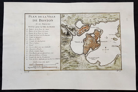
1756 J N Bellin Antique Map of The City of Boston & Charlestown
- Title : Plan de la Ville De Boston et ses Environs
- Ref #: 93417
- Size: 14 1/2in x 9 1/2in (350mm x 240mm)
- Date : 1756
- Condition: (A+) Fine Condition
Description:
This original hand coloured copper plate engraved antique map of Boston and surrounding areas - one of the earliest obtainable maps of the city - by Jacques Nicholas Bellin in 1756 - was published in the French edition of Antoine-François Prevosts 20 volume L Histoire Generale des Voyages published by Pierre de Hondt in the Hague between 1747 & 1785.
Beautiful map with great street and building detail in both Boston and Charlestown, showing parts of Ronde Isle and the mainland. Important buildings and areas identified in an idex at the left of the map. Including three cannon batteries, the Presbyterian Church, the Quaker temple, the Anabaptist Church, the City Hall, the Armory, Faneuil Hall (Spelled Fanal), etc. (Ref: Tooley; M&B)
General Definitions:
Paper thickness and quality: - Heavy and stable
Paper color : - off white
Age of map color: - Early
Colors used: - Yellow, green, blue, pink
General color appearance: - Authentic
Paper size: - 14 1/2in x 9 1/2in (350mm x 240mm)
Plate size: - 11 1/2in x 7 1/2in (285mm x 190mm)
Margins: - Min 1in (25mm)
Imperfections:
Margins: - None
Plate area: - Folds as issued
Verso: - None
Background:
Boston is the capital city and most populous municipality of the Commonwealth of Massachusetts in the United States.
Boston is one of the oldest cities in the United States, founded on the Shawmut Peninsula in 1630 by Puritan settlers from England. It was the scene of several key events of the American Revolution, such as the Boston Massacre, the Boston Tea Party, the Battle of Bunker Hill, and the Siege of Boston. Upon U.S. independence from Great Britain, it continued to be an important port and manufacturing hub as well as a center for education and culture.
In the 1820s, Boston\\\\\\\\\\\\\\\'s population grew rapidly, and the city\\\\\\\\\\\\\\\'s ethnic composition changed dramatically with the first wave of European immigrants. Irish immigrants dominated the first wave of newcomers during this period, especially following the Irish Potato Famine; by 1850, about 35,000 Irish lived in Boston. In the latter half of the 19th century, the city saw increasing numbers of Irish, Germans, Lebanese, Syrians, French Canadians, and Russian and Polish Jews settling in the city. By the end of the 19th century, Boston\\\\\\\\\\\\\\\'s core neighborhoods had become enclaves of ethnically distinct immigrants. Italians inhabited the North End, Irish dominated South Boston and Charlestown, and Russian Jews lived in the West End. Irish and Italian immigrants brought with them Roman Catholicism. Currently, Catholics make up Boston\\\\\\\\\\\\\\\'s largest religious community and the Irish have played a major role in Boston politics since the early 20th century; prominent figures include the Kennedys, Tip O\\\\\\\\\\\\\\\'Neill, and John F. Fitzgerald.
Between 1631 and 1890, the city tripled its area through land reclamation by filling in marshes, mud flats, and gaps between wharves along the waterfront. The largest reclamation efforts took place during the 19th century; beginning in 1807, the crown of Beacon Hill was used to fill in a 50-acre mill pond that later became the Haymarket Square area. The present-day State House sits atop this lowered Beacon Hill. Reclamation projects in the middle of the century created significant parts of the South End, the West End, the Financial District, and Chinatown.
After the Great Boston Fire of 1872, workers used building rubble as landfill along the downtown waterfront. During the mid- to-late 19th century, workers filled almost 600 acres of brackish Charles River marshlands west of Boston Common with gravel brought by rail from the hills of Needham Heights. The city annexed the adjacent towns of South Boston (1804), East Boston (1836), Roxbury (1868), Dorchester (including present day Mattapan and a portion of South Boston) (1870), Brighton (including present day Allston) (1874), West Roxbury (including present day Jamaica Plain and Roslindale) (1874), Charlestown (1874), and Hyde Park (1912). Other proposals were unsuccessful for the annexation of Brookline, Cambridge and Chelsea.