Recent Acquisitions (38)
1854 John Arrowsmith Rare Antique Map, Early Town Plan of Gladstone, Queensland
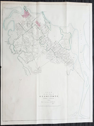
- Title : Plan of the Town of Gladstone Port Curtis 1854 (Water is very scarce in this locality)
- Size: 22 1/4in x 16 3/4in (565mm x 425mm)
- Condition: (A+) Fine Condition
- Date : 1854
- Ref #: 82046
Description:
Description:
This large, rare & important map, a very early plan of the Queensland town of Gladstone by John Arrowsmith was engraved in 1854 - dated - and was published for The Colonial Office Parliamentary Papers, London.
The rarity of this map cannot be overstated. Many of these maps by Arrowsmith were printed and published only for the British Colonial Office Parliamentary Papers and would have numbered only in the 100s.
John Arrowsmith is considered one of the finest cartographers of the 19th century, famous for producing highly accurate and finely engraved maps in atlases, books & in sheet form, of all parts of the know world. Ironically he is less famous for producing many of the maps that accompanied the British Colonial Office Parliamentary Reports between 1817 to 1890, with two-thirds of the maps being produced by Arrowsmith. These maps were published solely for government review and not public sale. A few of these were subsequently published in Arrowsmiths Atlases and vice versa but a great number of them were not, making many of the maps published for the Parliamentary papers rare and rarely seen on the market. Many of them are not called for in Tooley, Clancy or other important reference material.
This is one of those maps, one of 27 we were fortunate to procure earlier this year. I have found very little historical sales data for these maps and so I have priced them based on what I feel is a fair market value for such a rare, scarce map.
Gladstone is a city in the Gladstone Region, Queensland, Australia. It is approximately 550 km (340 mi) by road north of Brisbane and 100 km south-east of Rockhampton. Situated between the Calliope and Boyne Rivers, Gladstone is home to Queensland\'s largest multi-commodity shipping port.
Before European settlement, the Gladstone region was home of the Toolooa (or Tulua), Meerooni and Baiali (or Byellee) Aboriginal tribes.
In May 1770, the HM Bark Endeavour, under the command of James Cook, sailed by the entrance to Gladstone Harbour under the cover of darkness. Matthew Flinders, during his 1801–1803 circumnavigation of Australia, became the first recorded European to sight the harbour in August 1802. He named the harbour Port Curtis, after Admiral Roger Curtis, a man who was of assistance to Flinders a year earlier at the Cape of Good Hope. John Oxley conducted further exploration of the harbour and surrounding countryside in November 1823. Oxley was dismissive of the region, noting the harbour was difficult to enter, the countryside was too dry, and the timber useless for construction purposes.
Nevertheless, in 1847 the British attempted to establish the new colony of North Australia at Port Curtis. Colonel George Barney was chosen to lead this experiment in colonisation and his expedition was eventful. On 25 January 1847, the Lord Auckland, carrying 87 soldiers and convicts, arrived off the southern entrance of Port Curtis and promptly ran aground on shoals off the southern tip of Facing Island. The settlers spent seven weeks on the island before being rescued by the supply ship Thomas Lowry and delivered the intended site of settlement, the region now known as Barney Point. On 30 January at a proclamation ceremony, Barney was sworn in as Lieutenant Governor of the colony of North Australia. The convict settlement lasted barely two months and cost the Imperial government ₤15,000. A change of government in Britain ordered the withdrawal of Barney and the settlers. However, interest in the region remained.
By 1853, Francis MacCabe was surveying the site of a new town on the shores of Port Curtis under the protection of several detachments of Native Police. Maurice O\'Connell was appointed government resident the following year, resulting in an influx of free settlers as land became available throughout the region. In 1863, the town became a Municipality with Richard Hetherington elected Gladstones first mayor. The fledgling town was named after the British Prime Minister William Ewart Gladstone and has a 19th-century marble statue on display in its town museum.
General Definitions:
Paper thickness and quality: - Heavy and stable
Paper color : - off white
Age of map color: - Original
Colors used: - Blue, pink, green
General color appearance: - Authentic
Paper size: - 22 1/4in x 16 3/4in (565mm x 425mm)
Plate size: - 22 1/4in x 16 3/4in (565mm x 425mm)
Margins: - Min 1/2in (12mm)
Imperfections:
Margins: - None
Plate area: - Folds as issued
Verso: - None
Background:
The importance of John Arrowsmiths contribution to early Australian cartography cannot be stressed enough. He was responsible for producing many of the early exploration maps of Australia for the Colonial Offices & Government publications as well as the RGS.
Maps produced after the first settlement and into the 19th century came from varied sources, first published with the First Fleet Journals by Arthur Phillip, John Hunter and Watkin Tench. Numerous European publishing houses produced atlases which included maps of Australia. Many came out in several editions and were updated as new information became available. The Australian Colonies were administered by officials responsible to the British Colonial Office and all events of importance, often illustrated by maps, were published in the British Parliamentary Papers. There a rea prime source of maps from 1830 onwards, although one or two maps may be found in Parliamentary Papers prior to this time, such as one example of a rare map of the Swan River by Captain James Stirling.
During the 19th century, as the Australian colonies were progressively granted responsible government, Parliamentary Papers for each colony became an important source of maps. These maps sources have been a hidden and untapped resource. Another good source of early maps is published journals of the explorers; the explorers earliest maps often accompanied reports in the
Journal of the Royal Geographical Society in the UK. Parallel development of Australian scientific institutions along with an interest in exploration was a strong feature of 19th century Australia. The Royal Geographical Society of Australasia was established with branches in NSW, Victoria, South Australia and Queensland. A number of important maps were published as separate sheets, increasingly by Australian printers and engravers such as Carmichael, Sands & Kenny, and Higginbotham, Robinson & Harrison.
Australian atlases were produced and repeat editions of cadastral surveys and maritime chats became increasingly available. Specialist maps were published from official sources, including geological and mineral maps. Towards the end of the century a plethora of thematic maps were published through a verity of media such as advertisements for land sales, tourists maps and street directories.
Parliamentary Papers British Parliamentary Papers were a funnel for all significant colonial events in the 19th century. They included over one hundred maps with information on topography, exploration and lad survey published between 1817 and 1890., with two-thirds of the maps being produced by John Arrowsmith. Few maps are found after the early 1860s. The maps accompanying papers relevant to gold discovery (1851-55) are a particularly good resource, documenting an important time in the history of Australia. Perhaps the most neglected source of early Australian maps are those included in the Colonial Parliamentary Papers published locally after 1836. The NSW Parliamentary Papers published between 1836 and 1900 contain over 2700 maps on 129 topics, providing a unique record of events considered important by the colonial administration. Land ownership and land use dominate, followed by maps of services relevant to land use, such as railways, roads, water supply and sewerage. Public health issues are recorded in maps as are maps of gold& mineral leases reflected the expanding diversity of the economy. The first map published in the NSW Parliamentary Papers, of the site of the new Government House, was lithographed by W.R. Baker in 1836. The total number of maps over the same period from other colonies was less than 2000 but again each colonies priorities were reflected by in the subjects covered. Tasmania reflected mainly geological and early convict disciplinary maps; South Australia, land administration and pastoral development; Victoria, maps relating to the development; Victoria, maps relating to the colonies infrastructure, especially railway and harbour development; Queensland, railway and mineral leases; Western Australia, a broad range that included two important technological innovations that shortened the time, and therefore the cost, of printing maps. Firstly , John Osborn in 1859, developed the use of a transfer paper method in photolithography which reduced printing time from days to hours. Secondly, Alfred Selwyn in 1860 used a steam-driven power press to print seven colour geological maps.
Royal Geographical Society published its first journal in 1832. This journal was to become the leading scientific medium available for explorers to publish the first news of their discoveries. However, not all explorers were published here. Between 1832 and 1880, 25 maps recorded of inland Australia, illustrating the journeys of 27 explorers. John Arrowsmith compiled 22 of the 25 maps published by the RGS again illustrating the importance of Arrowsmith to the expansion of early colonial cartography in Australia.

1774 Cook & Hawkesworth Antique Atlas of Australia, New Zealand 52 Maps & Prints
- Title : Cartes et figures des voyages entrepris par ordre de sa Majesté Britannique, actuellement régnante ; pour faire des découvertes dans l'hémisphère méridional, et successivement exécutés par le Commodore Byron, le Capitaine Carteret, le Capitaine Wallis & le Capitaine Cook dans les vaisseaux. MDCCLXXIV (1774)
- Size: 4to (Quatro)
- Condition: (A) Very Good Condition
- Date : 1774
- Ref #: 35632
Description:
This original antique Atlas containing 52 maps and prints, as called for, from some of the foremost explorers of the mid 18th century, including Commodore Byron, Captain Carteret, Captain Wallis & Captain James Cook, was published as the 1st French edition of Cartes et figures des voyages entrepris par ordre de sa Majesté Britannique: (Maps and Figures of Travels undertaken by Order of his Present Reigning British Majesty) in 1774, published after only a year after the 1st English edition by John Hawkesworth.
The 52 prints and maps contained in this atlas chart in maps, prints and plans, the progression in the exploration of the South Seas of the 4 explorers. But there is of course, the standout amongst these 4 explorers and that is of course Captain James Cook.
At the time of the publication of this tome, Cook had returned from his first voyage of exploration to The South Pacific, becoming the first European to survey and chart the coastline of New Zealand and the east coast of Australia. But at this point Cook was not as famous as he was destined to become, after completing 2 more voyages of exploration, and in turn becoming the most famous explorer of his era.
The majority of this atlas contains the prints and maps dedicated to Cooks 1st Voyage of Discovery including the two famous maps, one of New Zealand and the other the East Coast of Australia. All voyages can be tracked from the first large folding map of the South Seas, at the beginning of the Atlas, that illustrates the tracks on Cook and the other 3 explorers.
In-4 binding in half-calf, spine with five bands with gilding boxes and title label complete with 52 folding & single plates
Spine & boards in poor condition with lack of leather and scratched covers, contents tights with plates in very good condition.
General Definitions:
Paper thickness and quality: - Heavy and stable
Paper color : - off white
Age of map color: -
Colors used: -
General color appearance: -
Paper size: - 4to (Quatro)
Plate size: - 4to (Quatro)
Margins: - 4to (Quatro)
Imperfections:
Margins: - Light age toning - Maps & Prints
Plate area: - Folds as issued - Maps & Prints
Verso: - Folds as issued - Maps & Prints
Background:
Capt. Cook First Voyage 1768 - 1771:
In 1768 Cook was chosen to lead an expedition to the South Seas to observe the Transit of Venus and to secretly search for the unknown Great Southern Continent (terra australis incognita).
Cook and his crew of nearly 100 men left Plymouth (August 1768) in the Endeavour and travelled via Madeira (September), Rio de Janiero (November-December) and Tierra del Fuego (January 1769) to Tahiti.
At Tierra del Fuego (January 1769) Cooks men went ashore and met the local people whom Cook thought perhaps as miserable a set of People as are this day upon Earth. Joseph Bankss party collected botanical specimens but his two servants, Thomas Richmond and George Dorlton, died of exposure in the snow and cold. Leaving Tierra del Fuego Endeavour rounded Cape Horn and sailed into the Pacific Ocean.
Sir Joseph Banks wrote about the homes of the Fuegans
..…huts or wigwams of the most unartificial construction imaginable, indeed no thing bearing the name of a hut could possibly be built with less trouble. They consisted of a few poles set up and meeting together at the top in a conical figure, these were covered on the weather side with a few boughs and a little grass, on the lee side about one eighth part of the circle was left open and against this opening was a fire made.......(Banks, Journal I, 224, 20th January 1769)
Samuel Wallis on the ship Dolphin discovered Tahiti in 1767. He recommended the island for the Transit of Venus observations and Cook arrived here in April 1769. Cook, like Wallis two years before him, anchored his ship in the shelter of Matavai Bay on the western side of the island.
In Matavai Bay Cook established a fortified base, Fort Venus, from which he was to complete his first task – the observation of the Transit of Venus (3rd June 1769). The fort also served as protection for all the important scientific and other equipment which had to be taken ashore as:
.......great and small chiefs and common men are firmly of opinion that if they can once get possession of an thing it immediately becomes their own…the chiefs employd in stealing what they could in the cabbin while their dependents took every thing that was loose about the ship…...(Joseph Banks).
Theft by some native peoples plagued Cooks voyages.
Cook and his crew experienced good relations with the Tahitians and returned to the islands on many occasions, attracted by the friendly people of this earthly paradise. On arrival Cook had set out the rules, including:
.....To endeavour by every fair means to cultivate a friendship with the Natives and to treat them with all imaginable humanity....
Just as Cook was planning to leave Tahiti two members of Endeavours crew decided to desert, having strongly attached themselves to two girls, but Cook recovered them.
Cook sailed around the neighbouring Society Islands and took on board the Tahitian priest, Tupaia, and his servant, Taiata. Endeavour left the Society Island in August 1769.
Tupaia acted as interpreter when they came into contact with other Polynesian peoples and helped Cook to make a map of the Pacific islands. This showed Cook the location of islands arranged according to their distance from Tahiti and indicated Tupaias and Polynesian knowledge of navigation and their skill as great mariners.
Cook sailed in search of the Southern Continent (August-October 1769) before turning west to New Zealand. The first encounters with the native Maori of New Zealand in October were violent, their warriors performing fierce dances, or hakas, in attempts to threaten and challenge the ships crew. Some of their warriors were killed when Cooks men had to defend themselves. Eventually relations improved and Cook was able to trade with the Maori for fresh supplies.
Exploring different bays and rivers along the way Cook circumnavigated New Zealand and was the first to accurately chart the whole of the coastline. He discovered that New Zealand consisted of two main islands, north (Te Ika a Maui) and south (Te Wai Pounamu) islands (October 1769-March 1770).
The artist Sydney Parkinson described three Maori who visited the Endeavour on 12th October 1769:
......Most of them had their hair tied up on the crown of their heads in a knot…Their faces were tataowed, or marked either all over, or on one side, in a very curious manner, some of them in fine spiral directions…
This Maori wears an ornamental comb, feathers in a top-knot, long pendants from his ears and a heitiki, or good luck amulet, around his neck.
At the northern end of the south island Cook anchored the ship in Ship Cove, Queen Charlotte Sound, which became a favourite stopping place on the following voyages. Parkinson noted:
......The manner in which the natives of this bay (Queen Charlotte Sound) catch their fish is as follows: - They have a cylindrical net, extended by several hoops at the bottom, and contracted at the top; within the net they stick some pieces of fish, then let it down from the side of the canoe and the fish, going in to feed, are caught with great ease.....(Parkinson, Journal, 114)
In Queen Charlottes Sound Cook visited one of the many Maori hippah, or fortified towns.
........The town was situated on a small rock divided from the main by a breach in a rock so small that a man might almost Jump over it; the sides were every where so steep as to render fortifications iven in their way almost totally useless, according there was nothing but a slight Palisade…in one part we observed a kind of wooden cross ornamented with feathers made exactly in the form of a crucifix cross…we were told that it was a monument to a dead man.......
Endeavour left New Zealand and sailed along the east coast of New Holland, or Australia, heading north (April-August 1770). Cook started to chart the east coast and on 29th April landed for the first time in what Cook called Stingray, later, Botany Bay.
The ship struck the Great Barrier Reef and was badly damaged (10 June). Repairs had to be carried out in Endeavour River. (June-August 1770). The first kangaroo to be sighted was recorded and shot.
The inhabitants of New Holland were very different from the people Cook had come across in other Pacific lands. They were darker skinned than the Maori and painted their bodies:
......They were all of them clean limnd, active and nimble. Cloaths they had none, not the least rag, those parts which nature willingly conceals being exposed to view compleatly uncovered......(Joseph Banks)
Tupaia could not make himself understood and at first the aborigines were very wary of the visitors and not at all interested in trading.
Joseph Banks recorded the fishing party observed at Botany Bay on 26 April 1770. He wrote:
......Their canoes… a piece of Bark tied together in Pleats at the ends and kept extended in the middle by small bows of wood was the whole embarkation, which carried one or two…people…paddling with paddles about 18 inches long, one of which they held in either hand.....(Banks, Journal II, 134)
Endeavour left Australia and sailed via the Possession Isle and Endeavour Strait for repairs at Batavia, Java (October-December 1770). Although the crew had been quite healthy and almost free from scurvy, the scourge of sailors, many caught dysentery and typhoid and over thirty died at Batavia or on the return journey home via Cape Town, South Africa (March-April 1771). The ship arrived off Kent, England (July 1771).
The voyage successfully recorded the Transit of Venus and largely discredited the belief in a Southern Continent. Cook charted the islands of New Zealand and the east coast of Australia and the scientists and artists made unique records of the peoples, flora and fauna of the different lands visited.
Vice-Admiral John Byron (1723-1786) was a British naval officer and explorer. He is known for his circumnavigation of the globe aboard the HMS Dolphin, completing one of the first British expeditions to achieve this feat. His account of the voyage, "The Narrative of the Honourable John Byron," influenced subsequent explorations. Byron's naval career included service in the Seven Years' War and the American Revolutionary War.
Rear-Admiral Philip Carteret (1733-1796) was a British naval officer and explorer. He is best known for his role as the captain of HMS Swallow during the first circumnavigation of the globe. Carteret's expedition, which took place from 1766 to 1769, aimed to explore and map uncharted regions of the Pacific Ocean. His discoveries included the Carteret Islands and the Pitcairn Islands. Carteret's voyage greatly contributed to the knowledge of Pacific geography and exploration during that time.
Samuel Wallis (1728-1795) was a British naval officer and explorer. He is renowned for leading the first recorded European expedition to visit Tahiti and for his significant contributions to the exploration of the Pacific Ocean. In 1766, Wallis commanded HMS Dolphin on a voyage funded by the British Admiralty. During the expedition, he discovered and named several islands, including Tahiti, which he encountered in June 1767. Wallis's visit to Tahiti marked the beginning of sustained European contact with the island and its inhabitants. His exploration efforts and subsequent reports greatly expanded European knowledge of the Pacific region. Wallis's achievements laid the foundation for future explorations and influenced subsequent voyages of exploration in the Pacific.
John Hawkesworth 1715 -1775
An English writer and journalist, Hawkesworth was commissioned by the British Admiralty to edit for publication the narratives of its officers circumnavigations. He was given full access to the journals of the commanders and the freedom to adapt and re-tell them in the first person. Cook was already on his way back from his second Pacific voyage, temporarily docked at Cape Town (South Africa), when he first saw the published volumes: he was mortified and furious to find that Hawkesworth claimed in the introduction that Cook had seen and blessed (with slight corrections) the resulting manuscript. (In his defense, Hawkesworth also had been a victim of misunderstanding.) Cook had trouble recognizing himself. Moreover, the work was full of errors and commentary introduced by Hawkesworth and, in Cooks view, too full of Banks, who had promoted himself and the publication. Still, the work was popular; the first edition sold out in several months.
Cook , Capt. James 1728-1779
James Cook was born on 27 October 1728 in Marton, England. His father was a poor farm labourer who had worked his way up to Overseer. James began as a farm labourer and grocer\\\'s assistant. He soon found employment on the Baltic sea in a Collier (coal transport ship) at the age of 18.
During the war with the French in 1755, James Cook enlisted as an Able Seaman on the Eagle. Within a month he was promoted, because of outstanding ability, to Masters Mate. Four years later he was promoted to Master. In command of his own ship, James Cook performed a crucial charting of the St. Lawrence River, which made possible the great amphibious assault upon Quebec City in 1759. In 1763 he was given command of the schooner Grenville to survey the eastern coasts of Canada over a four year period. These excellent charts were used up until the early part of the 20th century.
James Cook was selected to lead a 1768 expedition to observe the transit of Venus, and to explore new lands in the Pacific Ocean. In his first Pacific voyage, James Cook rounded Cape Horn in the Endeavour and reached Tahiti on 3 June 1769. After recovering a necessary scientific instrument stolen by the natives, the transit of Venus was successfully observed. The Endeavour then spent six months charting New Zealand. James Cook next explored and claimed possession of eastern Australia. Returning to England, on 12 June 1771, via New Guinea, Java and the Cape of Good Hope, the crew suffered an appalling 43% fatality rate. James Cook thus became very concerned about crew health on subsequent voyages. He instituted compulsory dietary reforms that were copied by many other ship captains.
The object of Captain Cook\\\'s second Pacific Ocean voyage was to confirm the existence of a theorized Great Southern Continent. His ship the Resolution, accompanied by the Adventure, departed Plymouth on 13 July 1772 and sailed around the Cape of Good Hope. Beset by ice, he was unable to reach Antarctica. Although its existence was suspected, James Cook demonstrated, by traversing large areas of the south Pacific, that it would have to be a frigid wasteland, and not an economically productive addition to the British empire. James Cook charted many of the South Pacific islands with the incredible accuracy of 3 miles. This accuracy was made possible by a new and highly accurate clock. The two ships returned to England, via Cape Horn, on 29 July 1775. The experimental diets and close attention to cleanliness had a miraculous effect: out of a crew of 118, only one man was lost to disease! Since public interest was high, the many paintings by the artists were widely displayed and published as engravings. James Cook was also awarded the Copley Gold Medal and elected as a fellow of the Royal Society.
The third great voyage is especially significant to the history of the west coast of North America. Captain Cook and his men were primarily searching for the Northwest Passage from the Pacific Ocean to the Atlantic Ocean. They departed Plymouth on 12 July 1776 in the Resolution and the Discovery.
The ships sailed around the Cape of Good Hope to reach the west coast of America in February of 1778. They continued north along the coast in haste to the Bering Sea and Bering Strait in an attempt to pass through the Arctic Ocean during the summer season. Foiled by ice, James Cook returned to Hawaii to prepare for another attempt at the Northwest Passage the next season. Soon after they had departed, a storm damaged the foremast of the Resolution and forced a return to Kealakekua Bay for repairs. Unfortunately, they had previously overstayed their welcome and relations became tense. The theft of a ship\\\'s cutter led Captain Cook to put ashore to demand the return of the boat. A fight broke out and James Cook was killed on 14 Feb 1779 by angry natives. Although his men made another attempt at the Northwest Passage, they were unsuccessful. The expedition did identify the possibilities of trade with the coastal American natives for otter seal furs, which could then be bartered for Chinese goods that were highly prized in England.
1851 John Tallis Antique Map of Western Australia or The Swan River Settlement
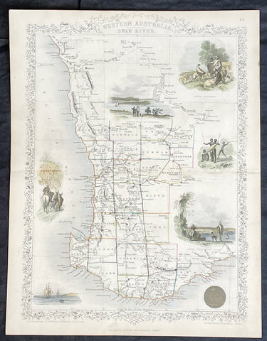
- Title : Western Australia Swan River
- Date : 1851
- Size: 14in x 11in (355mm x 280mm)
- Condition: (A+) Fine Condition
- Ref: 35523
Description:
This original hand coloured, steel plate engraved antique map of Western Australia or The Swan River Settlement, Australia with vignettes of Perth, Fremantle, Aboriginals and settlers was engraved by John Rapkin and published by John Tallis in 1851.
General Definitions:
Paper thickness and quality: - Heavy and stable
Paper color : - off white
Age of map color: - Original
Colors used: - Blue
General color appearance: - Authentic
Paper size: - 14in x 11in (355mm x 280mm)
Plate size: - 14in x 11in (355mm x 280mm)
Margins: - Min 1/2in (12mm)
Imperfections:
Margins: - None
Plate area: - None
Verso: - None
Background:
The firm of Tallis & Company flourished from 1835 to 1860 with varying imprints. Their illustrated Atlas of 1850-51 was one of the last decorative atlases, all the maps being engraved on steel and all adorned with small vignettes. (Ref: Tooley; M&B)
1851 John Tallis Antique Map of Van Diemens Land or Tasmania, Australia
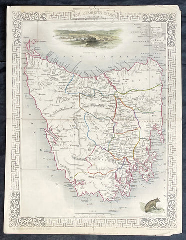
- Title : Van Diemens Land or Tasmania
- Date : 1851
- Size: 14in x 11in (355mm x 280mm)
- Condition: (A+) Fine Condition
- Ref: 35519
Description:
This original hand coloured, steel plate engraved antique map of Tasmania, Australia with vignettes of Hobart and Tasmanian Tiger was engraved by John Rapkin and published by John Tallis in 1851.
General Definitions:
Paper thickness and quality: - Heavy and stable
Paper color : - off white
Age of map color: - Original
Colors used: - Blue
General color appearance: - Authentic
Paper size: - 14in x 11in (355mm x 280mm)
Plate size: - 14in x 11in (355mm x 280mm)
Margins: - Min 1/2in (12mm)
Imperfections:
Margins: - None
Plate area: - None
Verso: - None
Background:
The firm of Tallis & Company flourished from 1835 to 1860 with varying imprints. Their illustrated Atlas of 1850-51 was one of the last decorative atlases, all the maps being engraved on steel and all adorned with small vignettes. (Ref: Tooley; M&B)
1851 John Tallis Antique Map of Victoria or Port Phillip, Australia
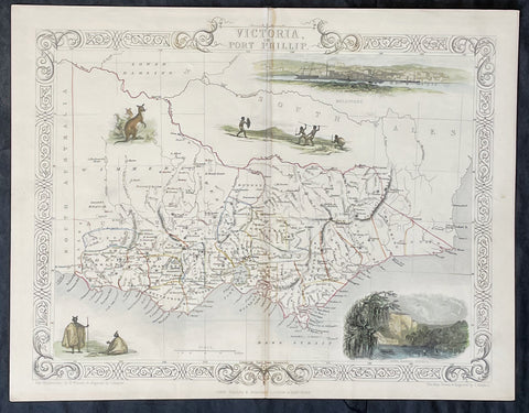
- Title : Victoria or Port Phillip
- Date : 1851
- Size: 14in x 11in (355mm x 280mm)
- Condition: (A+) Fine Condition
- Ref: 35503
Description:
This original hand coloured, steel plate engraved antique map of Victoria, Australia with vignettes of Glenelg River, Aboriginals and Kangaroos was engraved by John Rapkin and published by John Tallis in 1851.
General Definitions:
Paper thickness and quality: - Heavy and stable
Paper color : - off white
Age of map color: - Original
Colors used: - Blue
General color appearance: - Authentic
Paper size: - 14in x 11in (355mm x 280mm)
Plate size: - 14in x 11in (355mm x 280mm)
Margins: - Min 1/2in (12mm)
Imperfections:
Margins: - None
Plate area: - None
Verso: - None
Background:
The firm of Tallis & Company flourished from 1835 to 1860 with varying imprints. Their illustrated Atlas of 1850-51 was one of the last decorative atlases, all the maps being engraved on steel and all adorned with small vignettes. (Ref: Tooley; M&B)
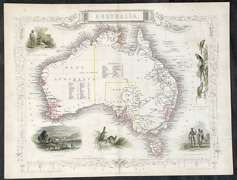
1851 John Tallis Antique Map of Australia
- Title : Australia
- Date : 1851
- Size: 14in x 11in (355mm x 280mm)
- Condition: (A+) Fine Condition
- Ref: 35511
Description:
This original hand coloured, steel plate engraved antique map of Australia with vignettes of Sydney Harbour, Aboriginals, Parrots and Kangaroos was engraved by John Rapkin and published by John Tallis in 1851.
General Definitions:
Paper thickness and quality: - Heavy and stable
Paper color : - off white
Age of map color: - Original
Colors used: - Blue
General color appearance: - Authentic
Paper size: - 14in x 11in (355mm x 280mm)
Plate size: - 14in x 11in (355mm x 280mm)
Margins: - Min 1/2in (12mm)
Imperfections:
Margins: - None
Plate area: - None
Verso: - None
Background:
The firm of Tallis & Company flourished from 1835 to 1860 with varying imprints. Their illustrated Atlas of 1850-51 was one of the last decorative atlases, all the maps being engraved on steel and all adorned with small vignettes. (Ref: Tooley; M&B)
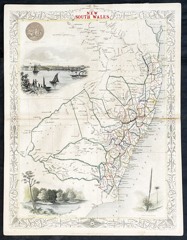
1851 John Tallis Antique Map of New South Wales, Australia
- Title : New South Wales
- Date : 1851
- Size: 14in x 11in (355mm x 280mm)
- Condition: (A+) Fine Condition
- Ref: 1554
Description:
This original hand coloured, steel plate engraved antique map of New South Wales, Australia with vignettes of Sydney Harbour and The Murray was engraved by John Rapkin and published by John Tallis in 1851.
General Definitions:
Paper thickness and quality: - Heavy and stable
Paper color : - off white
Age of map color: - Original
Colors used: - Blue
General color appearance: - Authentic
Paper size: - 14in x 11in (355mm x 280mm)
Plate size: - 14in x 11in (355mm x 280mm)
Margins: - Min 1/2in (12mm)
Imperfections:
Margins: - None
Plate area: - None
Verso: - None
Background:
The firm of Tallis & Company flourished from 1835 to 1860 with varying imprints. Their illustrated Atlas of 1850-51 was one of the last decorative atlases, all the maps being engraved on steel and all adorned with small vignettes. (Ref: Tooley; M&B)
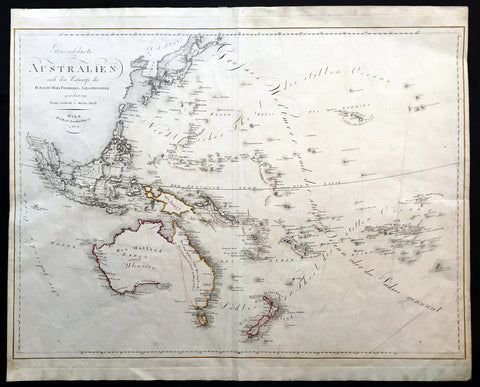
1815 Swoboda & Hartl Large Old, Antique Map of Australia, Ulimaroa New Zealand - Rare
- Title : Generalcharte von Australien nach dem entwurfe des H.Joseph Marx Freiherrn v. Liechtenstern
- Date : 1815
- Condition: (A+) Fine Condition
- Ref: 16258
- Size: 27 1/4in x 22in (695mm x 560mm)
Description:
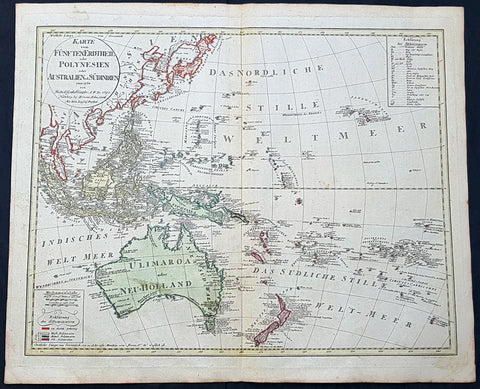
This large beautifully hand coloured original & scarce antique map of New Holland also named Ulimaroa, New Zealand and the South Pacific by Franz Swoboda and Martin Hartl was published in Vienna in 1815 - dated.
General Description:
Paper thickness and quality: - Heavy & stable
Paper color: - White
Age of map color: - Original
Colors used: - Red, yellow
General color appearance: - Authentic
Paper size: - 27 1/4in x 22in (695mm x 560mm)
Paper size: - 27in x 20 3/4in (685mm x 525mm)
Margins: - Min 1/4in (7mm)
Imperfections:
Margins: - None
Plate area: - Vertical crease right image
Verso: - None
This map is typical of the affect of Cooks discoveries on European cartography. Australia regularly became a focus on regional maps. The name "Ulimaroa" was often used, mainly by German & Austrian cartographers, at this time. It was term Cook learned from the New Zealand Maoris before discovering the east coast of Australia during his first voyage of discovery. When this map was printed there was a strong belief that the Australian continent was possibly divided by an internal sea strait, separating the east from the west coasts. It was explorers such as Flinders and Baudin who set out to find this elusive passage and if so the possible point at which a ship could enter.
Only a few years before in 1798 Flinders and Bass had proved that there was a strait dividing Van Diemen’s Land (Tasmania) from the rest of the continent so now the race was on to find the other passage. On Swoboda’s map a line has been drawn from the bottom of Carpentaria to the eastern part of present day Victoria. This line represented two things, the potential shape of the eastern landmass split by the sea and the extent to English territory in the newly settled colonies, only 17 years old. The Southern Coastline is not shown as even though Flinders had by 1803 mapped the entire region he was in 1805 still under house arrest on the islands of Mauritius by the French, he would not publish his discoveries until 1814. Therefore this map shows Australia at a pivotal point in its history when most of the continent was still open for settlement by other nations and the coastlines and mysteries were still to be confirmed. (Ref: Clancy; M&B; Tooley)
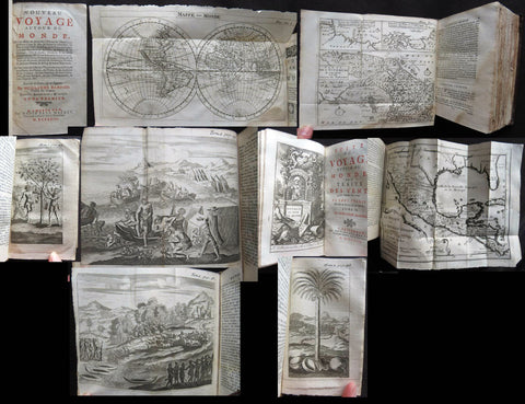
1723 William Dampier 2 Volumes of World Voyages to America Australia Asia - 20 x Maps & Plates
- Title : Nouveau Voyage Autour Du Monde...Ou l on decrite en particular l Isthme de l Amerique, plusieurs côtes et isles des Indes Occidentales...1723
- Size: 8vo
- Condition: (A) Very Good Condition
- Date : 1723
- Ref #: 93005
Description:
These two beautiful leather bound volumes of William Dampiers voyages to America, New Holland (Australia) and the East Indies, contains 5 titles with 20 maps & plates (some folding) and was published in Amsterdam by David Paul Marret in 1723 (dated)
These 2 volumes are the French translation of the voyages of the English explorer, ex-pirate and navigator, William Dampier, who became the first Englishman to explore parts of what is today Australia, and the first person to circumnavigate the world three times between 1679 & 1711. He has also been described as Australia\'s first natural historian, as well as one of the most important British explorers of the period between Sir Walter Raleigh and James Cook.
After impressing the British Admiralty with his book, A New Voyage Round the World, Dampier was given command of a Royal Navy ship and made important discoveries in western Australia, but was court-martialled for cruelty. On a later voyage, he rescued Alexander Selkirk, a former crew mate who may have inspired Daniel Defoe\'s Robinson Crusoe. Others influenced by Dampier include James Cook, Lord Nelson, Charles Darwin and Alfred Russel Wallace.
General Definitions:
Paper thickness and quality: - Heavy and stable
Paper color : - off white
Age of map color: -
Colors used: -
General color appearance: -
Paper size: - 8vo
Plate size: - 8vo
Margins: - Min 1/2in (12mm)
Imperfections:
Margins: - Please see below for condition report
Plate area: - Please see below for condition report
Verso: - Please see below for condition report
Background:
The two volumes contain the following 5 titles with 20 maps & plates.
Volume 1.
1. Nouveau Voyage Autour Du Monde...Ou l\'on decrite en particular l\'Isthme de l\'Amerique, plusieurs côtes et isles des Indes Occidentales, les Isles du Cap Verd, le passage par la Terre del Fuego, les côtes meridionales du Chili, du Perou & du Mexique; l\'Isle de Guam, Mindanao, & des autres Philippines, les isles orientales qui sont prés de Cambodie; de la Chine; Formosa; Luçon, Celebes, &c., la Nouvelle Hollande, les Isles de Sumatra, de Nicobar & de Sainte Helene & le Cap de Bonne Esperance...Ou l\'on traite des differens terroirs de tous ces pays, de leurs ports, des plantes, des fruits & des animaux qu\'on y trouve; de leurs habitans, de leurs coûtumes, de leur religion, de leur gouvernement, de leur negoce, &c....1723
This volume refers to Dampiers voyages to North & South America, East Indies, SE Asia, China, Australia & Africa.
Contains Title page, 8 maps & plates total of 340 pages.
a) Mappe-Monde - World map with Dampiers tracks.
b) Maps of the Isthmus of Panama and Central America
c) Print of Natives gathering fruit
d) Print of Dampier loading Gold from the New World
e) Voyage au tour du Monde title page
f) Map of Mexico & southern North America
g) Print of a battle in the East indies
h) Print of a coconut palm in East Indies
2. Suite du Voyage Autour du Monde... Avec un Traite Des Vents qui regnent dans toute..LA ZONE TORRIDE Enrichi de Cartes & de Figures..1723
This volume refers to the contuinuation of Dampiers voyages to North & South America, East Indies, SE Asia, China, Australia & Africa along with a description of global winds and tides.
Contains title page along with 6 maps & plates, 227 pages.
a) Engraved Voyage au Tour Du Monde
b) Print of ships offshore from the city of Manila in the Phillippines
c) View of Manila
d) 2nd print of ships offshore from the city of Manila in the Phillippines
e) Map of the Philippines islands of Banshee
f) Map of Pulocondor, Malayia
g) Print of Dampiers ship and compass rose
3. Traits des Vents Aliisez ou Reglez des Vents Frais ...1715
This volume refers again to globle winds & tides.
Contains title page 2 maps & 148 pages
a) Description of winds and tides in the eastern hemisphere
b) Description of winds and tides in the eastern hemisphere
Volume 2.
1. Voyage Autour Du Monde... Contenant une Description d\'Achin,
Ville de Sumatra, du Royaume de Tonquin & autres Places des Indes,
& de la Baye de Campeche. Ou l\'on traite des differens terroirs de tous ces pays, de leurs ports, des plantes, des fruits & des animaux qu\'on y trouve; de leurs
habitans, de leurs coûtumes, de leur religion, de leur gouvernement,
de leur negoce, &c...1723
This volume refers to the continuation of Dampiers travels in East Indies, SE Asia & Mexico
Contains title page, 4 maps & plates, 264 pages.
a) Royalty in Vietnam
b) Map of central & north America
b) Print of Vietnam
c) Map of Australia & East Indies
2. Voyages de Guillaume Dampier a la Baye de Campeche...1714
This volume refers to Dampiers travel to Campeche, Mexico.
Contains title page and 197 pages.
Condition Report: Two volumes bound in full leather with five raised bands to spines, and title label. Couple of minor chips to top of both spines. The leather is scuffed and little pitted/worn (see photos). Internally there are a couple of small chips to inner edges of front and rear end-papers. Inscription to front end-papers (Gift of W. Wood 1745) and bookplate to inside front board (Lord Sandys). The title page of volume III and following four or so leaves have damp staining, and there is light damp staining throughout Volume I & II. The damp staining has caused the leaves to become softer and little chipped, with some nicks/tears and chips. There is a tear/crease to top inner edge and chip to bottom corner of title page of volume I. Scattered pale foxing/browning. Several of the plates have occasional creases. Four leaves of volume III are gently detaching and two leaves of volume I are missing. A few leaves are a little faded. Overall VG, in readable with firm binding.
1795 (1806) Canzler Large Antique Map Australia, Ulimaroa, New Zealand SE Asia
- Title : Karte vom Funften Erdtheil oder Polynaesien-Inselwelt oder Australien oder Sudindien (Map of the fifth earth or Polynesia or Australia or South India.)
- Size: 24 1/4in x 20 1/2in (615mm x 520mm)
- Condition: (A+) Fine Condition
- Date : 1795 (1806)
- Ref #: 93121
Description:
This large original hand coloured copper-plate engraved, antique map of Australia, New Zealand and SE Asia by Friedrich Gottlieb Canzler in 1795, was published by the Homann Firm in 1806.
A distinct map with the short lived alternative name of Ulimaroa for New Holland, given by Canzler after Daniel Djurberg mistakenly interperated the New Zealand Maori word, Olhemaroa, from Cooks diary, for Australia. The real interpretation being Long Hand, the Maori name for New Caledonia.
There are two records in Cooks diary relating to Ulimaroa....
5th Feb 1769....This place we concluded to be the land difcovered by Tafman, which he called Cape Maria Van Diemen, and finding thefe people fo intelligent, we inquired farther, if they knew of any country befides their own: they anfwered, that they never had vifisted any other, but that their anceftors had told them, that to the N.W. by N., or N.N.W. there was a country of great extent, called Ulimaroa, which people had failed in a very large canoe
5th Feb 1770.....When we were under fail, our old man aTopaa came on board to take his leave of us, and as we were ftill defirous of making farther enquiries whether any memory of Tafman had been preferved among thefe people, Tupia was directed to afk him whether he had ever heard that fuch a veffel as ours had vifited the country. To this he replied in the negative, but faid, that his anceftors had told him there had once come to this place a fmall veffel, from a distant country, called Ulimaroa, in which were four men, who, upon coming on fhore, were all killed: upon being afked where this diftant land lay, he pointed to the northward. Of Ulimaroa we had heard fome-thing before, from people about the Bay of Iflands, who faid that their anceftors had vifisted it; and Tupia had alfo talked to us of Ulimaroa.
General Definitions:
Paper thickness and quality: - Heavy and stable
Paper color : - off white
Age of map color: - Original
Colors used: - Yellow, green, blue, pink
General color appearance: - Authentic
Paper size: - 24 1/4in x 20 1/2in (615mm x 520mm)
Plate size: - 24 1/2in x 19in (620mm x 490mm)
Margins: - Min 1in (25mm)
Imperfections:
Margins: - Light age toning
Plate area: - None
Verso: - None
Background:
Ulimaroa was a name given to Australia by the Swedish geographer and cartographer Daniel Djurberg in 1776. Djurberg adapted the name from Olhemaroa, a Māori word found in Hawkesworths edition of Captain James Cook and Sir Joseph Banks journals which is thought to have been a misunderstood translation — the Māori were actually referring to Grand Terre, the largest island of New Caledonia. Djurberg believed the name meant something like big red land, whereas modern linguists believe it meant long hand — echoing the geography of Grand Terre. The spurious name continued to be reproduced on certain European maps, particularly some Austrian, Czech, German and Swedish maps, until around 1820, including in Carl Almqvists 1817 novel Parjumouf Saga ifrån Nya Holland (Stockholm, 1817).
Canzler, Friedrich Gottlieb 1764-1811
Friedrich Gottlieb Canzler was born in Wolgast, Sweden in 1764. He graduated from the school in his hometown and from 1781 to 1783 the Sundische Gymnasium in Stralsund . He then studied history , geography , statistics and the Swedish language at the University of Göttingen . After completing his studies, he also received his doctorate and habilitation in Göttingen, and worked as a Privatdozent for history, geography, statistics and cameralistics .
In addition, he published in Göttingen from July 1789 to February 1791 the General Political State Newspaper for all Stands, for which he ran his own university and newspaper printing plant, and founded in 1797 an Academic Reading Museum. Two years later he was appointed Professor of Statistics, State Economics, Cameral, Financial and Commerz Sciences at the University of Greifswald where he worked until his death in 1811.
Selected Works:
- New magazine for recent history, Earth and ethnology. Leipzig 1790
- English language teaching for Germans. Göttingen 1796
- General Litteraturarchiv for history, geography and statistics. Leipzig 1792-1798 (as publisher)
- Map of the fifth earth or Polynesia or Australia or South India. Nuremberg 1795, 1805 and 1806 (as well as 1813 with corrections by Christian Gottlieb Reichard)
- Front India or Hindostan or East India on the side of the Ganges. Nuremberg 1804

1639 Jan Jansson Antique Map of East Indies, Australia - Voyage of Dufken, Spice Islands
- Title : Indiae Orientalis Nova Descriptio
- Ref #: 43144
- Size: 22 1/2in x 19in (570mm x 485mm)
- Date : 1639
- Condition: (A) Very Good Condition
Description:
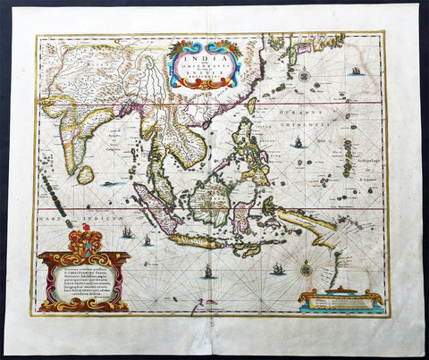
This beautiful, very significant original antique map of SE Asia, the East Indies PNG and significantly a small portion of the west coast of Australia's Cape York Peninsular was published in the 1639 French edition of Mercator's Atlas published by Henricus Hondius and Jan Jansson.
Condition Report:
Paper thickness and quality: - Heavy and stable
Paper color: - off white
Age of map color: - Later
Colors used: - Yellow, pink, green
General color appearance: - Authentic
Paper size: - 22 1/2in x 19in (570mm x 485mm)
Plate size: - 20in x 15 1/2in (510mm x 395mm)
Margins: - Min 1in (25mm)
Imperfections:
Margins: - Uniform age toning, bottom centerfold restored
Plate area: - Uniform age toning, centerfold re-joined
Verso: - Uniform age toning
Background: This landmark map is the first published record of the discoveries made by the Dutch ship Dufken on route to Cape York in Australia. New Guinea ("Landt vande Papuos") is marked the (Is)land next to it is called ÔNieu ZeelandtÕ and the island Duyfkens is named after the ship Duyfken.
With the first publication of this map 27 years had passed since the voyage of the Dufken and its discoveries of PNG and NW Australia had been completed. The Dutch East India Company had suppressed the discoveries until it was sure how profitable or not Australia would be.
Jansson & Hondius were the first to published this map in 1630 and it is believed the information was leaked from the Blaeu firm - the official cartographers to the Dutch East India Company. Surprisingly Blaeu did not publish a similar map for another two years. It must have been incredibly galling for Blaeu to have known of the discoveries for nearly thirty years and then to have been beaten to publication by his fiercest rival Jansson & Hondius.
Given this information this is an incredibly significant map of this imporatant region being the first map published with concrete first hand knowledge of the area which prior had been mapped based mainly on speculation or second hand knowledge.
The text running for two pages on the back of the map generally describes the region or country name, history (as it was), temperature, seasons, soil and agricultural productivity. Also described is the topography, wildlife, local inhabitants their culture and religion, as well as a description of major European and local towns and cities. This text makes extremely enjoyable reading and a very good insight not only into the area described but the general European attitudes towards alien countries and cultures. (Ref: Suraz; Koeman; M&B; Tooley)
1639 Hondius Antique Map of Australia, East Indies, India to China - Duyfken
- Title : India quae Orientalis dicitur et Insulae Adiacentes
- Date : 1639
- Condition: (A+) Fine Condition
- Ref: 43140
- Size: 22 1/2in x 19 1/4in (570mm x 485mm)
Description:
This fine beautifully hand coloured original antique and very important map of the East Indies, India, SE Asia, China, Japan Philippines and Australia - the first to map the west coast of Cape York Peninsular northern Queensland as well as parts of the SW coast of Western Australia, with place names, was published in the 1639 French edition of Mercators Atlas by Jan Jansson and Henricus Hondius.
An important Dutch map of South East Asia, noteworthy for including the discoveries made in New Guinea and northern Queensland, Australia by the Dutch vessel Duyfken in 1605-06. Under the command of Willem Janzoon, the Duyfken explored the eastern shore of the Gulf of Carpentaria, just below the Cape York Peninsula, a venture which was famously the first recorded European contact with Australia.
Condition Report
Paper thickness and quality: - Heavy and stable
Paper color: - off white
Age of map color: - Original
Colors used: - Red, yellow, green
General color appearance: - Authentic
Paper size: - 22 1/2in x 19 1/4in (570mm x 485mm)
Plate size: - 19 1/4in x 15 1/2in (485mm x 395mm)
Margins: - Min 1in (25mm)
Imperfections:
Margins: - Light age toning
Plate area: - Light offsetting, light age toning
Verso: - Light age toning
Background:
This map of the East Indies extending from India to Japan and south to Australia, shows some of the Dutch discoveries along the West Australian coastline like the Swan River, Nassau River, Coen River and the Batavia River borrows heavily from the exact map by Joan Blaeu. On the eastern part lower right of the map is a small section of Cape York Peninsular. This map is one of the first printed maps to show any part of the Australian coastline. It continued to be an issued unchanged from 1635 up until the 1660's, long after some of the information it contained had been superseded. This was despite the fact that Joan Blaeu as cartographer to the Dutch East India Company from 1638 to 1673 had access to the latest information concerning the extension of the Dutch maritime power in the East Indies, publishing the results of such discoveries (especially of Australia) on large World maps, such as that of 1648. In other words, atlas map's of the East Indies and part of Australia ignores the results of Abel Tasman's discoveries made during the voyage of 1642-44. In 1642, Tasman was appointed commander of an expedition to the South Seas, during which he discovered the Island later named after him as well as part of the coast of New Zealand. His voyage 1644 coasted along the shore of the Gulf of Carpentaria and along the northern coast of Australia as far as the Tropic of Capricorn.
Tasman's discoveries were published very soon afterwards on Blaeu's large World Maps, rendering it all the more curious that the atlas map was never revised. In affect, this map remained an historical map of the archipelago, showing discoveries made. albeit in a rather haphazard and fortuitous manner by the Dutch, between 1606 and 1623.. The design of the map emphasises the importance of the commercial interests in the East Indies, centred as it is on the heart of what was to become The Netherlands East Indies and later Indonesia. (Ref: Koeman; M&B)

1753 Bellin Antique Map of Australia & New Zealand - Carte Reduite.....Australes
- Title : Carte Reduite des Terres Australes pour Servir a l'Histoire des Voyages...1753
- Ref #: 17040
- Size: 15in x 10in (380mm x 255mm)
- Date : 1753
- Condition: (A+) Fine Condition
Description:
This original beautifully hand coloured copper plate engraved antique map of Australia - one of the earliest, near complete maps, dedicated to the Island Continent - was engraved in 1753 by Jacques Nicolas Bellin - date engraved in the title -and was published in the 1753 edition of Prevosts Histoire Generale Des Voyages.
Background: This is one of the few 18th century maps to focus on the Australian continent prior to Cook's famous first voyage from 1768-1771. Mainland Australia is connected to both Tasmania (Terre de Van Diemen) and Papua New Guinea (Nouv. Guinee). Along the imaginary eastern coastline is a note that reads: "I suppose that the land of Diemen can join with the land of the Holy Ghost, but this is without proof." A partial coastline of New Zealand is shown peeking out of the corner of the map, with a note that it was discovered by Abel Tasman in 1642 and speculation that it might be part of a great southern continent. This is an important map of Australia depicting the interesting theories made prior to exploration of the region later in the 18th century. (Ref: Tooley; M&B)
General Description:
Paper thickness and quality: - Heavy and stable
Paper color: - off white
Age of map color: - Early
Colors used: - Yellow, green, red, brown.
General color appearance: - Authentic and fresh
Paper size: - 15in x 10in (380mm x 255mm)
Plate size: - 11 1/2in x 8 1/2in (295mm x 215mm)
Margins: - Min 1in (25mm)
Imperfections:
Margins: - None
Plate area: - Folds as issued
Verso: - None

1753 Bellin Antique Map of Australia & New Zealand - Carte Reduite.....Australes
- Title : Carte Reduite des Terres Australes pour Servir a l'Histoire des Voyages...1753
- Ref #: 17027
- Size: 13 1/2in x 10in (340mm x 255mm)
- Date : 1753
- Condition: (A+) Fine Condition
Description:
This original copper plate engraved antique map of Australia - one of the earliest, near complete maps, dedicated to the Island Continent - was engraved in 1753 by Jacques Nicolas Bellin - date engraved in the title -and was published in Antoine Prevosts Histoire Generale Des Voyages.
Background: This is one of the few 18th century maps to focus on the Australian continent prior to Cook's famous first voyage from 1768-1771. Mainland Australia is connected to both Tasmania (Terre de Van Diemen) and Papua New Guinea (Nouv. Guinee). Along the imaginary eastern coastline is a note that reads: "I suppose that the land of Diemen can join with the land of the Holy Ghost, but this is without proof." A partial coastline of New Zealand is shown peeking out of the corner of the map, with a note that it was discovered by Abel Tasman in 1642 and speculation that it might be part of a great southern continent. This is an important map of Australia depicting the interesting theories made prior to exploration of the region later in the 18th century. (Ref: Tooley; M&B)
General Description:
Paper thickness and quality: - Heavy and stable
Paper color: - off white
Age of map color: -
Colors used: -
General color appearance: -
Paper size: - 13 1/2in x 10in (340mm x 255mm)
Plate size: - 11 1/2in x 8 1/2in (295mm x 215mm)
Margins: - Min 1in (25mm)
Imperfections:
Margins: - None
Plate area: - Folds as issued
Verso: - None

1730 George Seutter Large Antique Map of Australia, East Indies, SE Asia, China
- Title: India Orientalis cum Adjacentibus Insulis Nova Delineatione ob oculos posita ..Matth. Suettro.
- Date: 1730
- Condition: (A+) Condition
- Ref: 43155
- Size: 25 ½in x 21 ½in (650mm x 545mm)
Description: This large, scarce & beautifully hand coloured original map of Australia & SE Asia was published by Georg Mattraus Seutter in 1730. This is one of the best examples of this map I have seen, especially with the colouring. In excellent condition, a must in any Australian or SE Asian collection.
Condition Report
Paper thickness and quality: - Heavy and stable
Paper color: - off white
Age of map color: - Original & later
Colors used: - Yellow, pink, green, orange, blue
General color appearance: - Authentic
Paper size: - 25 ½in x 21 ½in (650mm x 545mm)
Plate size: - 23in x 19 1/4in (580mm x 490mm)
Margins: - Min 1in (25mm)
Imperfections:
Margins: - None
Plate area: - None
Verso: - None
Background: The map extends from China, Japan and Persia in the North and in the south stretching from The Maldives east to Northern Australia. Of note, Australia continues to be attached to Nova Guinea, albeit with some hesitation, as the image extends outside the inner neat-line to convey this information - even though 20+ names are confidently engraved around Northern Australia Coastline. The detail throughout Southeast Asia is informative and up-to-date and the print style typically strong. The cartouche is one of Seutter's most ornate, with elaborate scenes from sea, land, jungle and mythology. This map rarely appears on the market, as it was only included in select copies of Seutters atlas. (Ref: Norwich; M&B; Tooley)
1696 Alexis Hubert Jaillot Large Antique Map of Asia - Saudi Arabia to Australia
- Title : L' Asie divisee en ses Principales Regions....Hubert Jaillot....1696
- Ref #: 17022
- Size: 35 1/2in x 23in (900mm x 585mm)
- Date : 1696
- Condition: (A) Very Good Condition
Description:
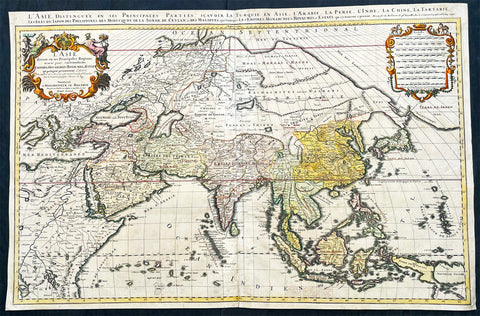
This very large original hand coloured antique map of Asia, from Arabia to the Gulf of Carpentaria, Australia, was engraved in 1696 - dated in title - and was published by Alexis Hubert Jaillot in his monumental Atlas Nouveau.
General Definitions:
Paper thickness and quality: - Heavy and stable
Paper color : - off white
Age of map color: - Original
Colors used: - Yellow, green, blue, pink
General color appearance: - Authentic
Paper size: - 35 1/2in x 23in (900mm x 585mm)
Plate size: - 34 1/2in x 22 1/2in (875mm x 570mm)
Margins: - Min 1/2in (15mm)
Imperfections:
Margins: - Light age toning in margin
Plate area: - Re-enforced along centerfold, light age toning, old ink text to bottom of map
Verso: - Soiling
Background:
The map include lines of latitude and longitude, some topographical details, location of settlements, rivers, and lakes (including the lakes Parime, thought to be where the fabulous El Dorado was located) as well as the boundaries of the possessions of the European claimants to South America.
Extremely decorative cartouche with dedication to Le Dauphin, and his coat of arms in top.
After Nicolas Sanson, Hubert Jaillot and Pierre Duval were the most important French cartographers of the seventeenth & eighteenth centuries. Jaillot, originally a sculptor, became interested in geography after his marriage to the daughter of Nicolas Berey (1606-65), a famous map colourist, and went into partnership in Paris with Sanson's sons. There, from about 1669, he undertook the re-engraving, enlarging and re-publishing of the Sanson maps in sheet form and in atlases, sparing no effort to fill the gap in the map trade left by the destruction of Blaeu's printing establishment in Amsterdam in 1672. Many of his maps were printed in Amsterdam (by Pierre Mortier) as well as in Paris. One of his most important works was a magnificent sea atlas, Le Neptune François, published in 1693 and compiled in co-operation with J D Cassini. This was re-published shortly afterwards by Pierre Mortier in Amsterdam with French, Dutch and English texts, the charts having been re-engraved. Eventually, after half a century, most of the plates were used again as the basis for a revised issue published by J N Bellin in 1753.(Ref: Tooley; M&B)
1774 Hawkesworth Large Antique Map of Australia & South Seas 1765-71 - Capt Cook
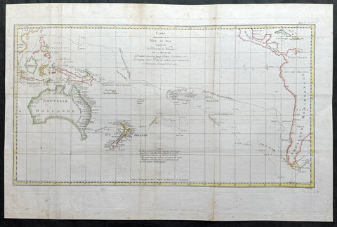
- Title : Carte d une Partie de la Mer du Sud Contenant les Decouvertes de Vaisseaux de sa Majeste, Le Dauphin, Commodore Byron, La Tamar, Capitne. Mouats 1765, Le Dauphin, Capitne. Wallis, Le Swallow, Capitne. Cartaret, 1767, et l Endeavour, Lieutenant Cook 1769
- Ref : 35509
- Size: 28in x 16 3/4in (710mm x 425mm)
- Date : 1774
- Condition: (A+) Fine Condition
Description:
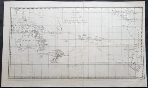
This fine original copper-plate engraved, large antique map, a chart of the tracks of 5 British ships & explorers to the South Ocean from 1765 to 1771 was engraved by Robert Benard and published in the 1774 French translation of John Hawkesworths publication An Account of the Voyages Undertaken by the Order of His Present Majesty for Making Discoveries in the Southern Hemisphere and Successively Performed by Commodore Byron, Captain Wallis, Captain Carteret, and Captain Cook, in the Dolphin, the Swallow, and the Endeavor, Drawn Up from the Journals Which Were Kept by the Several Commanders, and from the Papers of Joseph Banks
The 5 Voyages, with Captains, ships & tracks are;
1. 1764-66 - HMS Dolphin under Command of Commodore John Byron, completed the first circumnavigation of the globe under two years.
2. 1764-1766 - HMS Tamar under Command of Captain Patrick Mouat, accompanied Commodore John Byron & HMS Dolphin on 1764-66 circumnavigation of the world.
3. 1766-68 - HMS Dolphin under Command of Captain Samuel Wallis, completed another circumnavigation & was the first European to visit Tahiti & the Society Islands.
4. 1766-68 - HMS Swallow under Command of Captain Philip Carteret, who accompanied HMS Dolphin under the command of Samuel Wallis to circumnavigate the world.
5. 1769-71 - HMS Endeavour, under Command of Lieutenant James Cook (later Captain) completed a the mapping of Tahiti & the Society Islands, New Zealand & the East Coast of Australia.
General Definitions:
Paper thickness and quality: - Heavy and stable
Paper color : - off white
Age of map color: -
Colors used: -
General color appearance: -
Paper size: - 28in x 16 3/4in (710mm x 425mm)
Plate size: - 26 3/4in x 14 3/4in (680mm x 375mm)
Margins: - Min 1/2in (12mm)
Imperfections:
Margins: - None
Plate area: - Folds as issued
Verso: - None
Background:
Commodore John Byron 1723 – 1786 was a British Royal Navy officer and politician.He circumnavigated the world as a commodore with his own squadron in 1764-1766. He fought in battles in The Seven Years War and the American Revolution. He rose to Vice Admiral before his death in 1786.
Captain Patrick Mouat. Commanded HMS Tamer on a voyage of discovery with Commodore John Byron between 1764-66. HMS Tamar was a sloop, mounting sixteen guns: ninety men, three lieutenants, and two and twenty petty officers.
Captain Samuel Wallis 1728 – 1795 was a British naval officer and explorer of the Pacific Ocean. Was given the command of HMS Dolphin in 1751 as part of an expedition led by Philip Carteret in the Swallow with an assignment to circumnavigate the globe. The two ships were parted by a storm shortly after sailing through the Strait of Magellan, Wallis continuing to Tahiti, which he named King George the Third\'s Island in honour of the King in June 1767.
Captain Philip Carteret 1733 – 1796 was a British naval officer and explorer who participated in two of the Royal Navys circumnavigation expeditions in 1764–66 and 1766–69.
Captain James Cook is considered one of the most talented Surveyors & Map Makers of any age, for Cook, the production of a new chart was his principal reason for going to sea. His charts were aimed at fellow seamen so he incorporated as much information as possible while employing an economy of style and little elaboration. The quality of his charts can be confirmed by the fact that some survey details from Newfoundland to New Zealand & Australias East Coast could still be safely used over one hundred years later. His last piece of the New Zealand hydrographic chart was only removed in the 1990s.
John Hawkesworth An English writer and journalist, Hawkesworth was commissioned by the British Admiralty to edit for publication the narratives of its officers’ circumnavigations. He was given full access to the journals of the commanders and the freedom to adapt and re-tell them in the first person. Cook was already on his way back from his second Pacific voyage, temporarily docked at Cape Town (South Africa), when he first saw the published volumes: he was mortified and furious to find that Hawkesworth claimed in the introduction that Cook had seen and blessed (with slight corrections) the resulting manuscript. (In his defense, Hawkesworth also had been a victim of misunderstanding.) Cook had trouble recognizing himself. Moreover, the work was full of errors and commentary introduced by Hawkesworth and, in Cook’s view, too full of Banks, who had promoted himself and the publication. Still, the work was popular; the first edition sold out in several months.
Robert Bénard 1734 – 1777 was an 18th-century French engraver.
Specialized in the technique of engraving, Robert Ménard is mainly famous for having supplied a significant amount of plates (at least 1,800) to the Encyclopédie by Diderot & d Alembert from 1751.
Later, publisher Charles-Joseph Panckoucke reused many of his productions to illustrate the works of his catalog.
1774 James Cook Large Antique Map of The South Seas, Australia, New Zealand etc
- Title : Carte d une Partie de la Mer du Sud Contenant les Decouvertes de Vaisseaux de sa Majeste Le Dauphin, Commodore Byron La Tamar, Capitne. Mouats 1765 Le Dauphin, Capitne. Wallis Le Swallow, Capitne. Cartaret, 1767 et l Endeavour, Lieutenant Cook 1769
- Ref #: 17034
- Size: 28 1/2in x 18 3/4in (725mm x 475mm)
- Date : 1774
- Condition: (A) Very Good Condition
Description:
This large original hand coloured copper-plate engraved antique map, a chart of the voyage tracks of Captain James Cook during his first voyage of discovery of Australia & NZ, and 4 other explorers to the South Seas from 1765 to 1771. It was engraved by Robert Benard and published in the 1774 French translation of John Hawkesworths publication An Account of the Voyages Undertaken by the Order of His Present Majesty for Making Discoveries in the Southern Hemisphere and Successively Performed by Commodore Byron, Captain Wallis, Captain Carteret, and Captain Cook, in the Dolphin, the Swallow, and the Endeavor, Drawn Up from the Journals Which Were Kept by the Several Commanders, and from the Papers of Joseph Banks.
The 5 Voyages, with Captains, ships & tracks are;
1. 1764-66 - HMS Dolphin under Command of Commodore John Byron, completed the first circumnavigation of the globe under two years.
2. 1764-1766 - HMS Tamar under Command of Captain Patrick Mouat, accompanied Commodore John Byron & HMS Dolphin on 1764-66 circumnavigation of the world.
3. 1766-68 - HMS Dolphin under Command of Captain Samuel Wallis, completed another circumnavigation & was the first European to visit Tahiti & the Society Islands.
4. 1766-68 - HMS Swallow under Command of Captain Philip Carteret, who accompanied HMS Dolphin under the command of Samuel Wallis to circumnavigate the world.
5. 1769-71 - HMS Endeavour, under Command of Lieutenant James Cook (later Captain) completed a the mapping of Tahiti & the Society Islands, New Zealand & the East Coast of Australia.
General Definitions:
Paper thickness and quality: - Heavy and stable
Paper color : - off white
Age of map color: - Early
Colors used: - Yellow, brown, pink, red, blue
General color appearance: - Authentic
Paper size: - 28 1/2in x 18 3/4in (725mm x 475mm)
Plate size: - 27in x 15in (685mm x 380mm)
Margins: - Min 1in (25mm)
Imperfections:
Margins: - Folds as issued, light toning along folds
Plate area: - Folds as issued, light toning along folds
Verso: - Folds as issued, light toning along folds
Background:
Commodore John Byron 1723 – 1786 was a British Royal Navy officer and politician.He circumnavigated the world as a commodore with his own squadron in 1764-1766. He fought in battles in The Seven Years War and the American Revolution. He rose to Vice Admiral before his death in 1786.
Captain Patrick Mouat. Commanded HMS Tamer on a voyage of discovery with Commodore John Byron between 1764-66. HMS Tamar was a sloop, mounting sixteen guns: ninety men, three lieutenants, and two and twenty petty officers.
Captain Samuel Wallis 1728 – 1795 was a British naval officer and explorer of the Pacific Ocean. Was given the command of HMS Dolphin in 1751 as part of an expedition led by Philip Carteret in the Swallow with an assignment to circumnavigate the globe. The two ships were parted by a storm shortly after sailing through the Strait of Magellan, Wallis continuing to Tahiti, which he named King George the Third\'s Island in honour of the King in June 1767.
Captain Philip Carteret 1733 – 1796 was a British naval officer and explorer who participated in two of the Royal Navys circumnavigation expeditions in 1764–66 and 1766–69.
Captain James Cook is considered one of the most talented Surveyors & Map Makers of any age, for Cook, the production of a new chart was his principal reason for going to sea. His charts were aimed at fellow seamen so he incorporated as much information as possible while employing an economy of style and little elaboration. The quality of his charts can be confirmed by the fact that some survey details from Newfoundland to New Zealand & Australias East Coast could still be safely used over one hundred years later. His last piece of the New Zealand hydrographic chart was only removed in the 1990s.
John Hawkesworth An English writer and journalist, Hawkesworth was commissioned by the British Admiralty to edit for publication the narratives of its officers’ circumnavigations. He was given full access to the journals of the commanders and the freedom to adapt and re-tell them in the first person. Cook was already on his way back from his second Pacific voyage, temporarily docked at Cape Town (South Africa), when he first saw the published volumes: he was mortified and furious to find that Hawkesworth claimed in the introduction that Cook had seen and blessed (with slight corrections) the resulting manuscript. (In his defense, Hawkesworth also had been a victim of misunderstanding.) Cook had trouble recognizing himself. Moreover, the work was full of errors and commentary introduced by Hawkesworth and, in Cook’s view, too full of Banks, who had promoted himself and the publication. Still, the work was popular; the first edition sold out in several months.
Robert Bénard 1734 – 1777 was an 18th-century French engraver.
Specialized in the technique of engraving, Robert Ménard is mainly famous for having supplied a significant amount of plates (at least 1,800) to the Encyclopédie by Diderot & d Alembert from 1751.
Later, publisher Charles-Joseph Panckoucke reused many of his productions to illustrate the works of his catalog.
1778 Capt James Cook Antique Map The Southern Hemisphere, Australia, Antarctica
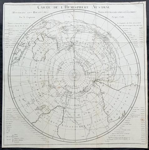
- Title : Carte De L Hemisphere Austral Montrant les Routes des Navigateurs les plus Celebree par le Capitaine Jacques Cook
- Ref : 42004
- Size: 22in x 21 1/2in (560mm x 545mm)
- Date : 1778
- Condition: (A) Very Good Condition
Description:
This fine original copper-plate engraved, antique map, a chart of the Southern Hemisphere, was engraved by Robert Benard and is dedicated to the discoveries in the South Seas and Antarctic Regions of Captain James Cook during his second Voyage of Discovery between 1772 & 1775. By comparison the tracks of 11 other explorers are included, from the 16th to the 18th centuries. The map by Captain James Cook was published in the 1778 French edition of A voyage towards the South Pole, and round the World. Performed in His Majestys ships the Resolution and Adventure, in the years 1772, 1773, 1774, and 1775..... Paris : Hotel de Thou ......1778
This map is unique in another way, as the English edition of this map was used as a prop, by Nathaniel Dance, in his 1776 portrait of Captain James Cook. Please also see above for the portrait.
The 11 other explorers and their tracks around the Southern Hemisphere are;
1. Mendana in 1595
2. Quiros in 1606
3. Le Maire & Schouten in 1616
4. Tasman in 1642
5. Halley in 1700
6. Roggewein in 1722
7. Bouvet in 1738-39
8. Byron in 1765
9. Wallis in 1767
10. Bougainville in 1768
11. Surville in 1769
12. Cooks first and second voyages.
General Definitions:
Paper thickness and quality: - Heavy and stable
Paper color : - off white
Age of map color: -
Colors used: -
General color appearance: -
Paper size: - 22in x 21 1/2in (560mm x 545mm)
Plate size: - 22in x 21 1/2in (560mm x 545mm)
Margins: - Min 1/2in (12mm)
Imperfections:
Margins: - Repair without loss to left of image
Plate area: - Folds as issued, light creasing along folds
Verso: - Folds as issued, light creasing along folds
Background:
This map by James Cook, was published as the premier map of his second voyage to the Southern Hemisphere, dispelling forever the myth of the Great Southern Land and showing the true cartographic nature of the southern hemisphere dominated by Australia & New Zealand. The map on a South Polar Projection also shows South America, the South Atlantic Ocean, South Africa, Madagascar, Australia - with Tasmania still joined to the mainland - New Zealand and the southern Pacific Ocean with islands.
Engraved within the explorer\\\'s tracks are the dates of their voyages and ships tracks are particularly noted around the Antarctic Circle with notations of ice fields seen during the voyages.
John Hawkesworth An English writer and journalist, Hawkesworth was commissioned by the British Admiralty to edit for publication the narratives of its officers’ circumnavigations. He was given full access to the journals of the commanders and the freedom to adapt and re-tell them in the first person. Cook was already on his way back from his second Pacific voyage, temporarily docked at Cape Town (South Africa), when he first saw the published volumes: he was mortified and furious to find that Hawkesworth claimed in the introduction that Cook had seen and blessed (with slight corrections) the resulting manuscript. (In his defense, Hawkesworth also had been a victim of misunderstanding.) Cook had trouble recognizing himself. Moreover, the work was full of errors and commentary introduced by Hawkesworth and, in Cook’s view, too full of Banks, who had promoted himself and the publication. Still, the work was popular; the first edition sold out in several months.
Robert Bénard 1734 – 1777 was an 18th-century French engraver.
Specialized in the technique of engraving, Robert Ménard is mainly famous for having supplied a significant amount of plates (at least 1,800) to the Encyclopédie by Diderot & d Alembert from 1751.
Later, publisher Charles-Joseph Panckoucke reused many of his productions to illustrate the works of his catalog.
1845 Johnston Large Antique Map of New South Wales & Victoria, Australia Felix
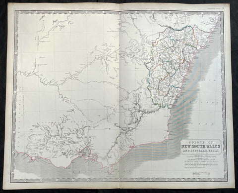
- Title : Colony of New South Wales and Australia Felix
- Ref #: 35088
- Size: 25 1/2in x 21in (650mm x 535mm)
- Date : 1845
- Condition: (A+) Fine Condition
Description:
This large fine hand coloured original antique map of NSW & SE Australia stretching from the 10 year old Settlement of Melbourne in the south to the 31st parallel in the north, by W & AK Johnston, was published in the 1845 edition of the General Atlas.
A large, highly detailed regional map of New South Wales and Australia Felix the SE area which quickly became the state of Victoria. The map, with this title, lasted for only a few years, before both NSW and Victoria were quickly settled. The map provides a very early depiction of the region, pre-dating the discovery of gold.
Also of great interest are the exploration routes by Mitchell (1836) in Red, Tyer's & Townsend's (1840) in Yellow and Streletsky's (Strzelecki) (1840) in Blue.
The 18 counties of NSW are highlighted in beautiful hand colour with extensive detail of towns, tracks and rivers. Historical note included below the title.Decorative Piano Key border and a fine example, on thick heavy paper.
Johnston was one of the master publishers of fine engraved and lithographed maps during the 19th century - this map is no exception. (Ref: Tooley; M&B)
General Description:
Paper thickness and quality: - Heavy and stable
Paper color: - off white
Age of map color: - Original
Colors used: - Red, green, yellow
General color appearance: - Authentic
Paper size: - 25 1/2in x 21in (650mm x 535mm)
Plate size: - 25 1/2in x 21in (650mm x 535mm)
Margins: - Min 1/2in (12mm)
Imperfections:
Margins: - None
Plate area: - None
Verso: - None
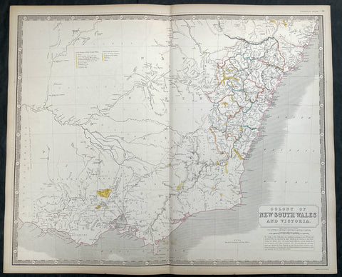
1856 A K Johnston Large Antique Goldfields Map of Victoria & New South Wales
- Title : Colony of New South Wales and Victoria by A K Johnston
- Date : 1856
- Condition: (A+) Fine Condition
- Ref: 27001
- Size: 25in x 21 1/2in (635mm x 545mm)
This original large hand coloured steel plate engraved antique map of NSW & Victoria - was published by A K Johnston in the 1856 edition of his National atlas of historical, commercial, and political geography.
A important and interesting map, showing some of the earliest and most important goldfields in both NSW & Victoria, illustrated in yellow with legend. the map is also one of the earliest to show the separation of the state of Victoria from New South Wales in 1851.
General Definitions:
Paper thickness and quality: - Heavy and stable
Paper color : - off white
Age of map color: - Original
Colors used: - Yellow, green, blue, pink
General color appearance: - Authentic
Paper size: - 25in x 21 1/2in (635mm x 545mm)
Plate size: - 25in x 21 1/2in (635mm x 545mm)
Margins: - Min 1/2in (12mm)
Imperfections:
Margins: - Light age toning
Plate area: - Light age toning
Verso: - Light age toning
Background:
The first gold rush in Australia began in May 1851 after prospector Edward Hargraves claimed to have discovered payable gold near Orange, at a site he called Ophir. Hargraves had been to the Californian goldfields and had learned new gold prospecting techniques such as panning and cradling. Hargraves was offered rewards by the Colony of New South Wales and the Colony of Victoria. Before the end of the year, the gold rush had spread to many other parts of the state where gold had been found, not just to the west, but also to the south and north of Sydney.
The Australian gold rushes changed the convict colonies into more progressive cities with the influx of free immigrants. These hopefuls, termed diggers, brought new skills and professions, contributing to a burgeoning economy. The mateship that evolved between these diggers and their collective resistance to authority led to the emergence of a unique national identity. Although not all diggers found riches on the goldfields, many decided to stay and integrate into these communities.
In July 1851, Victoria\\\'s first gold rush began on the Clunes goldfield. In August, the gold rush had spread to include the goldfield at Buninyong (today a suburb of Ballarat) 45 km (28 m) away and, by early September 1851, to the nearby goldfield at Ballarat (then also known as Yuille\\\'s Diggings) followed in early September to the goldfield at Castlemaine (then known as Forest Creek and the Mount Alexander Goldfield) and the goldfield at Bendigo (then known as Bendigo Creek) in November 1851. Gold, just as in New South Wales, was also found in many other parts of the state. The Victorian Gold Discovery Committee wrote in 1854:
The discovery of the Victorian Goldfields has converted a remote dependency into a country of world wide fame; it has attracted a population, extraordinary in number, with unprecedented rapidity; it has enhanced the value of property to an enormous extent; it has made this the richest country in the world; and, in less than three years, it has done for this colony the work of an age, and made its impulses felt in the most distant regions of the earth.
When the rush began at Ballarat, diggers discovered it was a prosperous goldfield. Lieutenant-Governor, Charles La Trobe visited the site and watched five men uncover 136 ounces of gold in one day. Mount Alexander was even richer than Ballarat. With gold sitting just under the surface, the shallowness allowed diggers to easily unearth gold nuggets. In 7 months, 2.4 million pounds of gold was transported from Mount Alexander to nearby capital cities.
The gold rushes caused a huge influx of people from overseas. Australia\\\'s total population more than tripled from 430,000 in 1851 to 1.7 million in 1871. Australia first became a multicultural society during the gold rush period. Between 1852 and 1860, 290,000 people migrated to Victoria from the British Isles, 15,000 came from other European countries, and 18,000 emigrated from the United States. Non-European immigrants, however, were unwelcome, especially the Chinese.
The Chinese were particularly industrious, with techniques that differed widely from the Europeans. This and their physical appearance and fear of the unknown led to them to being persecuted in a racist way that would be regarded as untenable today.
In 1855, 11,493 Chinese arrived in Melbourne. Chinese travelling outside of New South Wales had to obtain special re-entry certificates. In 1855, Victoria enacted the Chinese Immigration Act 1855, severely limiting the number of Chinese passengers permitted on an arriving vessel. To evade the new law, many Chinese were landed in the south-east of South Australia and travelled more than 400 km across country to the Victorian goldfields, along tracks which are still evident today.
In 1885, following a call by the Western Australian government for a reward for the first find of payable gold, a discovery was made at Halls Creek, sparking a gold rush in that state.
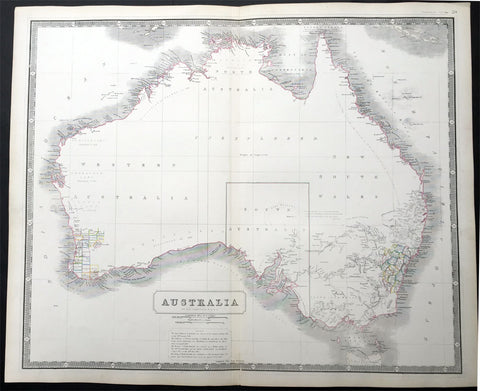
1844 W & AK Johnston Large Early Antique Map of Australia
- Title : Australia
- Date : 1844
- Condition: (A+) Fine Condition
- Ref: 30143
- Size: 25in x 21in (635mm x 535mm)
Description:
This large fine hand coloured original antique lithograph map of Australia - with coloured outlines to the counties in NSW & WA - was published by W & AK Johnston in General Atlas,1844.
At the bottom of the map is atext box outlining the period of settlements in Australia from Botany Bay in 1788, WA 1829, SA 1836 & the colony of Victoria begun some 8 years ealier in 1838.
Johnston was one of the master publishers of fine engraved and lithographed maps during the 19th century, this large map is no exception. (Ref: Tooley; M&B)
General Description:
Paper thickness and quality: - Heavy and stable
Paper color: - off white
Age of map color: - Original
Colors used: - Red, green, yellow
General color appearance: - Authentic
Paper size: - 25in x 21in (635mm x 535mm)
Plate size: - 25in x 21in (635mm x 535mm)
Margins: - Min 1/2in (12mm)
Imperfections:
Margins: - Light age toning
Plate area: - None
Verso: - None
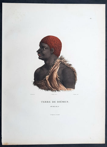
1807 Nicolas Baudin & N M Petit Antique Print of Tasmanian Aboriginal, Ourlaga
- Title : Terre De Diemen Ourlaga
- Size: 14in x 10in (355mm x 255mm)
- Condition: (A+) Fine Condition
- Date : 1807
- Ref #: 93089
Description:
This exquisite, rare original hand coloured copper-plate engraved antique print of Tasmanian Ourlaga, visited by Baudin Expedition to Australia in Feb. 1802, was engraved by Barthélemy Roger, after Nicolas-Martin Petit (the offical artist on the ship Géographe) and was published by Francois Peron (1775 - 1810) in the 1st edition atlas of Nicolas Thomas Baudins expedition to Australia Voyage de découvertes aux Terres Australes
General Definitions:
Paper thickness and quality: - Heavy and stable
Paper color : - off white
Age of map color: - Original
Colors used: - Yellow, green, blue, pink
General color appearance: - Authentic
Paper size: - 14in x 10in (355mm x 255mm)
Plate size: - 14in x 10in (355mm x 255mm)
Margins: - Min 1/2in (12mm)
Imperfections:
Margins: - None
Plate area: - None
Verso: - None
Background:
The Baudin Expedition of 1800 to 1803 was a French expedition to map the coast of New Holland, Australia. The expedition started with two ships, Géographe, captained by Baudin, and Naturaliste captained by Jacques Hamelin, and was accompanied by nine zoologists and botanists, including Jean-Baptiste Leschenault de la Tour, François Péron and Charles-Alexandre Lesueur as well as the geographer Pierre Faure.
The Baudin expedition departed Le Havre, France, on 19 October 1800. Because of delays in receiving his instructions and problems encountered in Isle de France (now Mauritius) they did not reach Cape Leeuwin on the south-west corner of Australia until May 1801. Upon rounding Cape Naturaliste, they entered Geographe Bay. They then sailed north, but the ships became separated and did not meet again until they reached Timor. On their journeys the Géographe and the Naturaliste surveyed large stretches of the north-western coast. The expedition was severely affected by dysentery and fever, but sailed from Timor on 13 November 1801, back down the north-west and west coast, then across the Great Australian Bight, reaching Tasmania on 13 January 1802. They charted the whole length of Tasmanias east coast and there were extensive interactions with the Indigenous Tasmanians, with whom they had peaceful relationships. They notably produced precious ethnological studies of Indigenous Tasmanians.
The expedition then began surveying the south coast of Australia, but then Captain Jacques Felix Emmanuel Hamelin in Naturaliste decided to make for Port Jackson (Sydney) as he was running short of food and water, and in need of anchors. En route, in April 1802, Hamelin explored the area of Western Port, Victoria, and gave names to places, a number of which have survived, for example, Ile des Français is now called French Island.
Meanwhile, Baudin in the Géographe continued westward, and in April 1802 encountered the British ship Investigator commanded by Matthew Flinders, also engaged in charting the coastline, at Encounter Bay in what is now South Australia. Flinders informed Baudin of his discovery of Kangaroo Island, St. Vincents and Spencers Gulfs. Baudin sailed on to the Nuyts Archipelago, the point reached by t Gulden Zeepaert in 1627 before heading for Port Jackson as well for supplies.
In late 1802 the expedition was at Port Jackson, where the government sold 60 casks of flour and 25 casks of salt meat to Baudin to resupply his two vessels. The supplies permitted Naturaliste to return to France and Géographe to continue her explorations of the Australian coast. Naturaliste took with her the Colonys staff surgeon, Mr. James Thomson, whom Governor Philip Gidley King had given permission to return to England.
Before resuming the voyage Baudin purchased a 30 ton schooner, which he named the Casuarina, a smaller vessel which could conduct close inshore survey work. He sent the larger Naturaliste under Hamelin back to France with all the specimens that had been collected by Baudin and his crew. As the voyage had progressed Louis de Freycinet, now a Lieutenant, had shown his talents as an officer and a hydrographer and so was given command of the Casuarina. The expedition then headed for Tasmania and conducted further charting of Bass Strait before sailing west, following the west coast northward, and after another visit to Timor, undertook further exploration along the north coast of Australia. Plagued by contrary winds, ill health, and because the quadrupeds and emus were very sick, it was decided on 7 July 1803 to return to France. On the return voyage, the ships stopped in Mauritius, where Baudin died of tuberculosis on 16 September 1803. The expedition finally reached France on 24 March 1804.
The scientific expedition was considered a great success, with more than 2500 new species discovered.
Nicolas-Martin Petit 1777 – 1804
Nicholas-Martin Petit was born in Paris, the son of a fan maker, and learned graphic art in the studio of Jacques Louis David. He avoided conscription into Napoleons armies, but wanting to travel, signed up with post Captain Nicholas Baudin on a voyage to the antipodes sponsored by the French government. Petit and fellow artist Charles-Alexandre Lesueur were enlisted directly by Baudin (as 4th class gunners mates) while the two official artists were hired by the organisers of the expedition. Baudin set off in two lavishly equipped vessels, the Géographe and the Naturaliste on 19 October 1800. By the time the expedition reached Mauritius the official artists had quit. Petit and Lesueur took over their duties, but as neither was trained in scientific method or presentation, the value of their work was primarily aesthetic. The French were at this time developing a new scientific field - anthropology. The Society of the Observers of Man was founded in 1799 for this purpose. The study of Man formed part of the background for Petits sensitive drawings and paintings of the indigenous people of Van Diemens Land, Port Jackson and Western Australia. Lesueur focused on the depiction of animals. The expedition charted the coast of Western Australia and Van Diemens land but was plagued by scurvy. On 20 June 1802 the two ships limped into Port Jackson and stayed for five months to refit, during which time Petit completed a number of portraits of Sydney Indigenous people, including the two images of the Eora men, Cour-rou-bari-gal and Y-erren-gou-la-ga. Petit eventually returned to France in 1804. However, before he was well enough to complete the drawings from the expedition he was hurt in a street accident, and he died at the age of 28. Petits unfinished work was first published in 1807 in the Atlas of the Voyage de découvertes aux terres australes and as discrete prints.
Baudin, Nicolas Thomas 1754 – 1803
Baudin was a French explorer, cartographer, naturalist and hydrographer. Born a commoner in Saint-Martin-de-Ré on the Île de Ré on 17 February 1754 Baudin joined the merchant navy at the age of 15 and the French East India Company at the age of 20.
Baudin then joined the La Marine Royale (French Navy) in 1774 and served in the Caribbean as an officier bleu during the American War of Independence of 1775–1783.
In 1785 Baudin and his brother Alexandre were respectively masters of the St Remy and Caroline, taking Acadian settlers from Nantes to La Nouvelle Orléans. In New Orleans local merchants contracted him to take a cargo of wood, salted meat, cod and flour to Isle de France (now Mauritius), which he did in Josephine (also called Pepita), departing New Orleans on 14 July 1786 and arriving at Isle de France on 27 March 1787. In the course of the voyage, Josephine had called at Cap‑Français in Haiti to make a contract to transport slaves there from Madagascar; while in Haiti he also encountered the Austrian botanist Franz Josef Maerter, who apparently informed him that another Austrian botanist, Franz Boos, was at the Cape of Good Hope awaiting a ship to take him to Mauritius. Josephine called at the Cape and took Boos on board. At Mauritius, Boos chartered Baudin to transport him and the collection of plant specimens he had gathered there and at the Cape back to Europe, which Baudin did, Josephine arriving at Trieste on 18 June 1788. The Imperial government in Vienna was contemplating organizing another natural-history expedition, to which Boos would be appointed, in which two ships would be sent to the Malabar and Coromandel coasts of India, the Persian Gulf, Bengal, Ceylon, Sumatra, Java, Borneo, Cochin China, Tongking, Japan and China. Baudin had been given reason to hope that he would be given command of the ships of this expedition.
Later in 1788 Baudin sailed on a commercial voyage from Trieste to Canton in Jardiniere. He apparently arrived at Canton from Mauritius under the flag of the United States of America, probably to avoid the possibility of having his ship seized by the Chinese for payment of the debts owed them by the Imperial Asiatic Company of Trieste. From there, he sent Jardiniere under her second captain on a fur-trading venture to the north-west coast of America, but the ship foundered off Asuncion Island in the Marianas in late 1789.
Baudin made his way to Mauritius, where he purchased a replacement ship, Jardiniere II, but this vessel was wrecked in a cyclone that struck Port Louis on 15 December 1789. Baudin embarked on the Spanish Royal Philippines Company ship, Placeres, which sailed from Port Louis for Cadiz in August 1790. Placeres called at the Cape of Good Hope where it took on board the large number of plant and animal specimens collected in South Africa for the Imperial palace at Schönbrunn by Georg Scholl, the assistant of Franz Boos. Because of the poor condition of the ship, Placeres had to put in at the island of Trinidad in the West Indies, where Scholls collection of specimens was deposited.
Baudin proceeded to Martinique, from where he addressed an offer to the Imperial government in Vienna to conduct to Canton commissioners who would be empowered to negotiate with the Chinese merchants there a settlement of the debts incurred by the Imperial Asiatic Company, which would enable the company to renew its trade with China. On its return voyage from Canton, the proposed expedition would call at the Cape of Good Hope to pick up Scholl and the remainder of his natural-history collection for conveyance to Schönbrunn.
After returning to Vienna in September 1791, Baudin continued to press his case for an expedition under the Imperial flag to the Indian Ocean and China, and in January 1792 he was granted a commission of captain in the Imperial navy for this purpose. A ship, called Jardiniere, was acquired and the botanists Franz Bredemeyer and Joseph van der Schot appointed to the expedition. After delays caused by the outbreak of war between France and Austria (April 1792), Jardiniere departed from the Spanish port of Málaga on 1 October 1792. From the Cape of Good Hope Jardiniere sailed across the Indian Ocean to the coast of New Holland (Australia), but two consecutive cyclones prevented the expedition from doing any work there and forced Baudin to take the ship to Bombay for repairs.
From Bombay the expedition proceeded to the Persian Gulf, the Red Sea and the east coast of Africa, where it gathered botanical and zoological collections. The expedition came to an abrupt end in June 1794 when Jardiniere went aground in a storm while attempting to enter Table Bay at the Cape of Good Hope. Baudin survived the wreck and made his way to the United States, from where he went to France. He managed to send Jardinieres cargo of natural history specimens to the island of Trinidad.
In Paris, Baudin visited Antoine de Jussieu at the Museum National dHistoire Naturelle in March 1796 to suggest a botanical voyage to the Caribbean, during which he would recover the collection of specimens he had left in Trinidad. The Museum and the French government accepted the proposal, and Baudin was appointed commander of an expedition in the ship Belle Angélique, with four assigned botanists: René Maugé, André Pierre Ledru, Anselme Riedlé and Stanislas Levillain. Belle Angélique cleared Le Havre on 30 September 1796 for the Canary Islands, where the ship was condemned as unseaworthy. The expedition sailed from the Canaries in a replacement vessel, Fanny, and reached Trinidad in April 1797. The British, who had just captured the island from the Spanish in February 1797, refused to allow Baudin to recover the collection of natural-history specimens. Baudin took Fanny to St. Thomas and St. Croix, and then to Puerto Rico, specimens being collected in all three islands. At St Croix, Fanny was replaced by a newly purchased ship, renamed Belle Angelique. The expedition returned to France in June 1798 with a large collection of plants, birds and insects, which was incorporated into Napoleon Bonapartes triumphal procession celebrating his recent Italian victories.
On 24 July 1798, at the suggestion of the Ministry of Marine, Baudin presented to the Assembly of Professors and Administrators of the National Museum of Natural History a plan for a hydrographic-survey expedition to the South Seas, which would include a search for fauna and flora that could be brought back for cultivation in France. The expedition would also have the aim of promoting the economic and commercial interests of France in the regions to be visited. The expedition would require two well-equipped ships, which would carry a team of astronomers, naturalists and scientific draughtsmen over whom Baudin as commander would have absolute authority. The first part of the voyage would be devoted to a thorough exploration of the coast of Chile and the collection of animal, bird and plant specimens suitable for acclimatization in France, followed by a survey of the coasts from Peru to Mexico. The expedition would then continue into the Pacific Ocean, including a visit to Tahiti and the Society Islands, and would be completed with a survey of the yet unexplored south-west coast of New Holland (Australia). After considering this extensive proposal, the French government decided to proceed with an expedition confined to a survey of western and southern New Holland (as Australia was called at the time).
In October 1800 Baudin was selected to lead what has become known as the Baudin expedition to map the coast of Australia (New Holland). He had two ships, Géographe and Naturaliste captained by Hamelin, and a suite of nine zoologists and botanists, including Jean Baptiste Leschenault de la Tour. He reached Australia in May 1801, and would explore and map the western coast and a part of the little-known southern coast of the continent. The scientific expedition proved a great success, with more than 2500 new species discovered. The French also met Aboriginal peoples and treated them with great respect.
In April 1802 Baudin met Matthew Flinders, also engaged in charting the coastline, in Encounter Bay in present-day South Australia. Baudin then stopped at the British colony at Sydney for supplies. In Sydney he bought a new ship — Casuarina — named after the wood it was made from. From there he sent home Naturaliste, which had on board all of the specimens that had been discovered by Baudin and his crew. He then headed for Tasmania, before continuing north to Timor. Baudin then sailed for home, stopping at Mauritius.
According to recent researches by academics from the University of Adelaide, during Baudins expedition, François Péron, who had become the chief zoologist and intellectual leader of the mission, wrote a report for Napoleon on ways to invade and capture the British colony at Sydney Cove.
Baudin died of tuberculosis at Mauritius on 16 September 1803, at the age of 49, apparently in the home of Madame Alexandrine Kerivel. Baudins exact resting place is not known, but the historian Auguste Toussaint believed that he was interred in the Kerivel family vault. However, the historian Edward Duyker likes to think that Baudin was buried in Le Cimetière de lOuest in the district of Port Louis just a few hundred metres from the explorers certain love: the sea.
Please note all items auctioned are genuine, we do not sell reproductions. A Certificate of Authenticity (COA) can be issued on request.
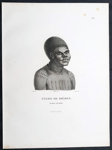
1807 Nicolas Baudin & N M Petit Antique Print of Tasmanian Aboriginal Bara-Ourou
- Title : Terre De Diemen Bara-Ourou
- Size: 13in x 10in (330mm x 255mm)
- Condition: (A+) Fine Condition
- Date : 1807
- Ref #: 93088
Description:
This exquisite, rare original copper-plate engraved antique print of Tasmanian Bara-Ourou, portrait of a young man 28-30 years of age, visited by Baudin Expedition to Australia in Feb. 1802, was engraved by Barthélemy Roger, after Nicolas-Martin Petit (the offical artist on the ship Géographe) and was published by Francois Peron (1775 - 1810) in the 1st edition atlas of Nicolas Thomas Baudins expedition to Australia Voyage de découvertes aux Terres Australes
Nicholas Martin Petit sailed with Nicolas Baudin on the expedition of the Géographe and the Naturaliste in late 1800. The scientific field of anthropology was in its infancy – the French had founded the Society of the Observers of Man in 1799. Having embarked as a fourth-class gunner’s mate, Petit, who had had some graphic arts training, became one of the expeditions two illustrators when the official artists quit. From June to November 1802, the expedition was delayed in Sydney while its two ships were repaired. During this time Petit completed portraits of people of the Cadigal, Dharawal, Gweagal, Kurringai and Darug language groups of the Sydney Harbour region. While the sitters names appear to be noted on the works, it is possible that the inscriptions merely reflect French misinterpretation of the Aborigines communications with them.
The portrait of Nourou-gal-derri is pictured advancing for battle.
General Definitions:
Paper thickness and quality: - Heavy and stable
Paper color : - off white
Age of map color: -
Colors used: -
General color appearance: -
Paper size: - 14in x 10in (355mm x 255mm)
Plate size: - 14in x 10in (355mm x 255mm)
Margins: - Min 1/2in (12mm)
Imperfections:
Margins: - None
Plate area: - None
Verso: - None
Background:
The Baudin Expedition of 1800 to 1803 was a French expedition to map the coast of New Holland, Australia. The expedition started with two ships, Géographe, captained by Baudin, and Naturaliste captained by Jacques Hamelin, and was accompanied by nine zoologists and botanists, including Jean-Baptiste Leschenault de la Tour, François Péron and Charles-Alexandre Lesueur as well as the geographer Pierre Faure.
The Baudin expedition departed Le Havre, France, on 19 October 1800. Because of delays in receiving his instructions and problems encountered in Isle de France (now Mauritius) they did not reach Cape Leeuwin on the south-west corner of Australia until May 1801. Upon rounding Cape Naturaliste, they entered Geographe Bay. They then sailed north, but the ships became separated and did not meet again until they reached Timor. On their journeys the Géographe and the Naturaliste surveyed large stretches of the north-western coast. The expedition was severely affected by dysentery and fever, but sailed from Timor on 13 November 1801, back down the north-west and west coast, then across the Great Australian Bight, reaching Tasmania on 13 January 1802. They charted the whole length of Tasmanias east coast and there were extensive interactions with the Indigenous Tasmanians, with whom they had peaceful relationships. They notably produced precious ethnological studies of Indigenous Tasmanians.
The expedition then began surveying the south coast of Australia, but then Captain Jacques Felix Emmanuel Hamelin in Naturaliste decided to make for Port Jackson (Sydney) as he was running short of food and water, and in need of anchors. En route, in April 1802, Hamelin explored the area of Western Port, Victoria, and gave names to places, a number of which have survived, for example, Ile des Français is now called French Island.
Meanwhile, Baudin in the Géographe continued westward, and in April 1802 encountered the British ship Investigator commanded by Matthew Flinders, also engaged in charting the coastline, at Encounter Bay in what is now South Australia. Flinders informed Baudin of his discovery of Kangaroo Island, St. Vincents and Spencers Gulfs. Baudin sailed on to the Nuyts Archipelago, the point reached by t Gulden Zeepaert in 1627 before heading for Port Jackson as well for supplies.
In late 1802 the expedition was at Port Jackson, where the government sold 60 casks of flour and 25 casks of salt meat to Baudin to resupply his two vessels. The supplies permitted Naturaliste to return to France and Géographe to continue her explorations of the Australian coast. Naturaliste took with her the Colonys staff surgeon, Mr. James Thomson, whom Governor Philip Gidley King had given permission to return to England.
Before resuming the voyage Baudin purchased a 30 ton schooner, which he named the Casuarina, a smaller vessel which could conduct close inshore survey work. He sent the larger Naturaliste under Hamelin back to France with all the specimens that had been collected by Baudin and his crew. As the voyage had progressed Louis de Freycinet, now a Lieutenant, had shown his talents as an officer and a hydrographer and so was given command of the Casuarina. The expedition then headed for Tasmania and conducted further charting of Bass Strait before sailing west, following the west coast northward, and after another visit to Timor, undertook further exploration along the north coast of Australia. Plagued by contrary winds, ill health, and because the quadrupeds and emus were very sick, it was decided on 7 July 1803 to return to France. On the return voyage, the ships stopped in Mauritius, where Baudin died of tuberculosis on 16 September 1803. The expedition finally reached France on 24 March 1804.
The scientific expedition was considered a great success, with more than 2500 new species discovered.
Nicolas-Martin Petit 1777 – 1804
Nicholas-Martin Petit was born in Paris, the son of a fan maker, and learned graphic art in the studio of Jacques Louis David. He avoided conscription into Napoleons armies, but wanting to travel, signed up with post Captain Nicholas Baudin on a voyage to the antipodes sponsored by the French government. Petit and fellow artist Charles-Alexandre Lesueur were enlisted directly by Baudin (as 4th class gunners mates) while the two official artists were hired by the organisers of the expedition. Baudin set off in two lavishly equipped vessels, the Géographe and the Naturaliste on 19 October 1800. By the time the expedition reached Mauritius the official artists had quit. Petit and Lesueur took over their duties, but as neither was trained in scientific method or presentation, the value of their work was primarily aesthetic. The French were at this time developing a new scientific field - anthropology. The Society of the Observers of Man was founded in 1799 for this purpose. The study of Man formed part of the background for Petits sensitive drawings and paintings of the indigenous people of Van Diemens Land, Port Jackson and Western Australia. Lesueur focused on the depiction of animals. The expedition charted the coast of Western Australia and Van Diemens land but was plagued by scurvy. On 20 June 1802 the two ships limped into Port Jackson and stayed for five months to refit, during which time Petit completed a number of portraits of Sydney Indigenous people, including the two images of the Eora men, Cour-rou-bari-gal and Y-erren-gou-la-ga. Petit eventually returned to France in 1804. However, before he was well enough to complete the drawings from the expedition he was hurt in a street accident, and he died at the age of 28. Petits unfinished work was first published in 1807 in the Atlas of the Voyage de découvertes aux terres australes and as discrete prints.
Baudin, Nicolas Thomas 1754 – 1803
Baudin was a French explorer, cartographer, naturalist and hydrographer. Born a commoner in Saint-Martin-de-Ré on the Île de Ré on 17 February 1754 Baudin joined the merchant navy at the age of 15 and the French East India Company at the age of 20.
Baudin then joined the La Marine Royale (French Navy) in 1774 and served in the Caribbean as an officier bleu during the American War of Independence of 1775–1783.
In 1785 Baudin and his brother Alexandre were respectively masters of the St Remy and Caroline, taking Acadian settlers from Nantes to La Nouvelle Orléans. In New Orleans local merchants contracted him to take a cargo of wood, salted meat, cod and flour to Isle de France (now Mauritius), which he did in Josephine (also called Pepita), departing New Orleans on 14 July 1786 and arriving at Isle de France on 27 March 1787. In the course of the voyage, Josephine had called at Cap‑Français in Haiti to make a contract to transport slaves there from Madagascar; while in Haiti he also encountered the Austrian botanist Franz Josef Maerter, who apparently informed him that another Austrian botanist, Franz Boos, was at the Cape of Good Hope awaiting a ship to take him to Mauritius. Josephine called at the Cape and took Boos on board. At Mauritius, Boos chartered Baudin to transport him and the collection of plant specimens he had gathered there and at the Cape back to Europe, which Baudin did, Josephine arriving at Trieste on 18 June 1788. The Imperial government in Vienna was contemplating organizing another natural-history expedition, to which Boos would be appointed, in which two ships would be sent to the Malabar and Coromandel coasts of India, the Persian Gulf, Bengal, Ceylon, Sumatra, Java, Borneo, Cochin China, Tongking, Japan and China. Baudin had been given reason to hope that he would be given command of the ships of this expedition.
Later in 1788 Baudin sailed on a commercial voyage from Trieste to Canton in Jardiniere. He apparently arrived at Canton from Mauritius under the flag of the United States of America, probably to avoid the possibility of having his ship seized by the Chinese for payment of the debts owed them by the Imperial Asiatic Company of Trieste. From there, he sent Jardiniere under her second captain on a fur-trading venture to the north-west coast of America, but the ship foundered off Asuncion Island in the Marianas in late 1789.
Baudin made his way to Mauritius, where he purchased a replacement ship, Jardiniere II, but this vessel was wrecked in a cyclone that struck Port Louis on 15 December 1789. Baudin embarked on the Spanish Royal Philippines Company ship, Placeres, which sailed from Port Louis for Cadiz in August 1790. Placeres called at the Cape of Good Hope where it took on board the large number of plant and animal specimens collected in South Africa for the Imperial palace at Schönbrunn by Georg Scholl, the assistant of Franz Boos. Because of the poor condition of the ship, Placeres had to put in at the island of Trinidad in the West Indies, where Scholls collection of specimens was deposited.
Baudin proceeded to Martinique, from where he addressed an offer to the Imperial government in Vienna to conduct to Canton commissioners who would be empowered to negotiate with the Chinese merchants there a settlement of the debts incurred by the Imperial Asiatic Company, which would enable the company to renew its trade with China. On its return voyage from Canton, the proposed expedition would call at the Cape of Good Hope to pick up Scholl and the remainder of his natural-history collection for conveyance to Schönbrunn.
After returning to Vienna in September 1791, Baudin continued to press his case for an expedition under the Imperial flag to the Indian Ocean and China, and in January 1792 he was granted a commission of captain in the Imperial navy for this purpose. A ship, called Jardiniere, was acquired and the botanists Franz Bredemeyer and Joseph van der Schot appointed to the expedition. After delays caused by the outbreak of war between France and Austria (April 1792), Jardiniere departed from the Spanish port of Málaga on 1 October 1792. From the Cape of Good Hope Jardiniere sailed across the Indian Ocean to the coast of New Holland (Australia), but two consecutive cyclones prevented the expedition from doing any work there and forced Baudin to take the ship to Bombay for repairs.
From Bombay the expedition proceeded to the Persian Gulf, the Red Sea and the east coast of Africa, where it gathered botanical and zoological collections. The expedition came to an abrupt end in June 1794 when Jardiniere went aground in a storm while attempting to enter Table Bay at the Cape of Good Hope. Baudin survived the wreck and made his way to the United States, from where he went to France. He managed to send Jardinieres cargo of natural history specimens to the island of Trinidad.
In Paris, Baudin visited Antoine de Jussieu at the Museum National dHistoire Naturelle in March 1796 to suggest a botanical voyage to the Caribbean, during which he would recover the collection of specimens he had left in Trinidad. The Museum and the French government accepted the proposal, and Baudin was appointed commander of an expedition in the ship Belle Angélique, with four assigned botanists: René Maugé, André Pierre Ledru, Anselme Riedlé and Stanislas Levillain. Belle Angélique cleared Le Havre on 30 September 1796 for the Canary Islands, where the ship was condemned as unseaworthy. The expedition sailed from the Canaries in a replacement vessel, Fanny, and reached Trinidad in April 1797. The British, who had just captured the island from the Spanish in February 1797, refused to allow Baudin to recover the collection of natural-history specimens. Baudin took Fanny to St. Thomas and St. Croix, and then to Puerto Rico, specimens being collected in all three islands. At St Croix, Fanny was replaced by a newly purchased ship, renamed Belle Angelique. The expedition returned to France in June 1798 with a large collection of plants, birds and insects, which was incorporated into Napoleon Bonapartes triumphal procession celebrating his recent Italian victories.
On 24 July 1798, at the suggestion of the Ministry of Marine, Baudin presented to the Assembly of Professors and Administrators of the National Museum of Natural History a plan for a hydrographic-survey expedition to the South Seas, which would include a search for fauna and flora that could be brought back for cultivation in France. The expedition would also have the aim of promoting the economic and commercial interests of France in the regions to be visited. The expedition would require two well-equipped ships, which would carry a team of astronomers, naturalists and scientific draughtsmen over whom Baudin as commander would have absolute authority. The first part of the voyage would be devoted to a thorough exploration of the coast of Chile and the collection of animal, bird and plant specimens suitable for acclimatization in France, followed by a survey of the coasts from Peru to Mexico. The expedition would then continue into the Pacific Ocean, including a visit to Tahiti and the Society Islands, and would be completed with a survey of the yet unexplored south-west coast of New Holland (Australia). After considering this extensive proposal, the French government decided to proceed with an expedition confined to a survey of western and southern New Holland (as Australia was called at the time).
In October 1800 Baudin was selected to lead what has become known as the Baudin expedition to map the coast of Australia (New Holland). He had two ships, Géographe and Naturaliste captained by Hamelin, and a suite of nine zoologists and botanists, including Jean Baptiste Leschenault de la Tour. He reached Australia in May 1801, and would explore and map the western coast and a part of the little-known southern coast of the continent. The scientific expedition proved a great success, with more than 2500 new species discovered. The French also met Aboriginal peoples and treated them with great respect.
In April 1802 Baudin met Matthew Flinders, also engaged in charting the coastline, in Encounter Bay in present-day South Australia. Baudin then stopped at the British colony at Sydney for supplies. In Sydney he bought a new ship — Casuarina — named after the wood it was made from. From there he sent home Naturaliste, which had on board all of the specimens that had been discovered by Baudin and his crew. He then headed for Tasmania, before continuing north to Timor. Baudin then sailed for home, stopping at Mauritius.
According to recent researches by academics from the University of Adelaide, during Baudins expedition, François Péron, who had become the chief zoologist and intellectual leader of the mission, wrote a report for Napoleon on ways to invade and capture the British colony at Sydney Cove.
Baudin died of tuberculosis at Mauritius on 16 September 1803, at the age of 49, apparently in the home of Madame Alexandrine Kerivel. Baudins exact resting place is not known, but the historian Auguste Toussaint believed that he was interred in the Kerivel family vault. However, the historian Edward Duyker likes to think that Baudin was buried in Le Cimetière de lOuest in the district of Port Louis just a few hundred metres from the explorers certain love: the sea.
Please note all items auctioned are genuine, we do not sell reproductions. A Certificate of Authenticity (COA) can be issued on request.
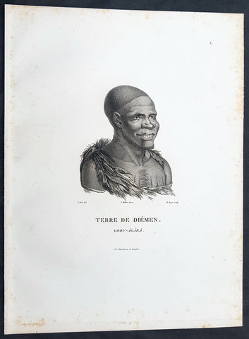
1807 Nicolas Baudin & N M Petit Antique Print of Tasmanian Aboriginal Grou Agara
- Title : Terre De Diemen Grou Agara
- Size: 13in x 10in (330mm x 255mm)
- Condition: (A+) Fine Condition
- Date : 1807
- Ref #: 93086
Description:
This exquisite, rare original copper-plate engraved antique print of Tasmanian Aboriginal Grou Agara, visited by the Baudin Expedition to Australia in Feb. 1802, was engraved by Barthélemy Roger, after Nicolas-Martin Petit (the offical artist on the ship Géographe) and was published by Francois Peron (1775 - 1810) in the 1st edition atlas of Nicolas Thomas Baudins expedition to Australia Voyage de découvertes aux Terres Australes
Nicholas Martin Petit sailed with Nicolas Baudin on the expedition of the Géographe and the Naturaliste in late 1800. The scientific field of anthropology was in its infancy – the French had founded the Society of the Observers of Man in 1799. Having embarked as a fourth-class gunner’s mate, Petit, who had had some graphic arts training, became one of the expeditions two illustrators when the official artists quit. From June to November 1802, the expedition was delayed in Sydney while its two ships were repaired. During this time Petit completed portraits of people of the Cadigal, Dharawal, Gweagal, Kurringai and Darug language groups of the Sydney Harbour region. While the sitters names appear to be noted on the works, it is possible that the inscriptions merely reflect French misinterpretation of the Aborigines communications with them.
The portrait of Nourou-gal-derri is pictured advancing for battle.
General Definitions:
Paper thickness and quality: - Heavy and stable
Paper color : - off white
Age of map color: -
Colors used: -
General color appearance: -
Paper size: - 14in x 10in (355mm x 255mm)
Plate size: - 14in x 10in (355mm x 255mm)
Margins: - Min 1/2in (12mm)
Imperfections:
Margins: - None
Plate area: - None
Verso: - None
Background:
The Baudin Expedition of 1800 to 1803 was a French expedition to map the coast of New Holland, Australia. The expedition started with two ships, Géographe, captained by Baudin, and Naturaliste captained by Jacques Hamelin, and was accompanied by nine zoologists and botanists, including Jean-Baptiste Leschenault de la Tour, François Péron and Charles-Alexandre Lesueur as well as the geographer Pierre Faure.
The Baudin expedition departed Le Havre, France, on 19 October 1800. Because of delays in receiving his instructions and problems encountered in Isle de France (now Mauritius) they did not reach Cape Leeuwin on the south-west corner of Australia until May 1801. Upon rounding Cape Naturaliste, they entered Geographe Bay. They then sailed north, but the ships became separated and did not meet again until they reached Timor. On their journeys the Géographe and the Naturaliste surveyed large stretches of the north-western coast. The expedition was severely affected by dysentery and fever, but sailed from Timor on 13 November 1801, back down the north-west and west coast, then across the Great Australian Bight, reaching Tasmania on 13 January 1802. They charted the whole length of Tasmanias east coast and there were extensive interactions with the Indigenous Tasmanians, with whom they had peaceful relationships. They notably produced precious ethnological studies of Indigenous Tasmanians.
The expedition then began surveying the south coast of Australia, but then Captain Jacques Felix Emmanuel Hamelin in Naturaliste decided to make for Port Jackson (Sydney) as he was running short of food and water, and in need of anchors. En route, in April 1802, Hamelin explored the area of Western Port, Victoria, and gave names to places, a number of which have survived, for example, Ile des Français is now called French Island.
Meanwhile, Baudin in the Géographe continued westward, and in April 1802 encountered the British ship Investigator commanded by Matthew Flinders, also engaged in charting the coastline, at Encounter Bay in what is now South Australia. Flinders informed Baudin of his discovery of Kangaroo Island, St. Vincents and Spencers Gulfs. Baudin sailed on to the Nuyts Archipelago, the point reached by t Gulden Zeepaert in 1627 before heading for Port Jackson as well for supplies.
In late 1802 the expedition was at Port Jackson, where the government sold 60 casks of flour and 25 casks of salt meat to Baudin to resupply his two vessels. The supplies permitted Naturaliste to return to France and Géographe to continue her explorations of the Australian coast. Naturaliste took with her the Colonys staff surgeon, Mr. James Thomson, whom Governor Philip Gidley King had given permission to return to England.
Before resuming the voyage Baudin purchased a 30 ton schooner, which he named the Casuarina, a smaller vessel which could conduct close inshore survey work. He sent the larger Naturaliste under Hamelin back to France with all the specimens that had been collected by Baudin and his crew. As the voyage had progressed Louis de Freycinet, now a Lieutenant, had shown his talents as an officer and a hydrographer and so was given command of the Casuarina. The expedition then headed for Tasmania and conducted further charting of Bass Strait before sailing west, following the west coast northward, and after another visit to Timor, undertook further exploration along the north coast of Australia. Plagued by contrary winds, ill health, and because the quadrupeds and emus were very sick, it was decided on 7 July 1803 to return to France. On the return voyage, the ships stopped in Mauritius, where Baudin died of tuberculosis on 16 September 1803. The expedition finally reached France on 24 March 1804.
The scientific expedition was considered a great success, with more than 2500 new species discovered.
Nicolas-Martin Petit 1777 – 1804
Nicholas-Martin Petit was born in Paris, the son of a fan maker, and learned graphic art in the studio of Jacques Louis David. He avoided conscription into Napoleons armies, but wanting to travel, signed up with post Captain Nicholas Baudin on a voyage to the antipodes sponsored by the French government. Petit and fellow artist Charles-Alexandre Lesueur were enlisted directly by Baudin (as 4th class gunners mates) while the two official artists were hired by the organisers of the expedition. Baudin set off in two lavishly equipped vessels, the Géographe and the Naturaliste on 19 October 1800. By the time the expedition reached Mauritius the official artists had quit. Petit and Lesueur took over their duties, but as neither was trained in scientific method or presentation, the value of their work was primarily aesthetic. The French were at this time developing a new scientific field - anthropology. The Society of the Observers of Man was founded in 1799 for this purpose. The study of Man formed part of the background for Petits sensitive drawings and paintings of the indigenous people of Van Diemens Land, Port Jackson and Western Australia. Lesueur focused on the depiction of animals. The expedition charted the coast of Western Australia and Van Diemens land but was plagued by scurvy. On 20 June 1802 the two ships limped into Port Jackson and stayed for five months to refit, during which time Petit completed a number of portraits of Sydney Indigenous people, including the two images of the Eora men, Cour-rou-bari-gal and Y-erren-gou-la-ga. Petit eventually returned to France in 1804. However, before he was well enough to complete the drawings from the expedition he was hurt in a street accident, and he died at the age of 28. Petits unfinished work was first published in 1807 in the Atlas of the Voyage de découvertes aux terres australes and as discrete prints.
Baudin, Nicolas Thomas 1754 – 1803
Baudin was a French explorer, cartographer, naturalist and hydrographer. Born a commoner in Saint-Martin-de-Ré on the Île de Ré on 17 February 1754 Baudin joined the merchant navy at the age of 15 and the French East India Company at the age of 20.
Baudin then joined the La Marine Royale (French Navy) in 1774 and served in the Caribbean as an officier bleu during the American War of Independence of 1775–1783.
In 1785 Baudin and his brother Alexandre were respectively masters of the St Remy and Caroline, taking Acadian settlers from Nantes to La Nouvelle Orléans. In New Orleans local merchants contracted him to take a cargo of wood, salted meat, cod and flour to Isle de France (now Mauritius), which he did in Josephine (also called Pepita), departing New Orleans on 14 July 1786 and arriving at Isle de France on 27 March 1787. In the course of the voyage, Josephine had called at Cap‑Français in Haiti to make a contract to transport slaves there from Madagascar; while in Haiti he also encountered the Austrian botanist Franz Josef Maerter, who apparently informed him that another Austrian botanist, Franz Boos, was at the Cape of Good Hope awaiting a ship to take him to Mauritius. Josephine called at the Cape and took Boos on board. At Mauritius, Boos chartered Baudin to transport him and the collection of plant specimens he had gathered there and at the Cape back to Europe, which Baudin did, Josephine arriving at Trieste on 18 June 1788. The Imperial government in Vienna was contemplating organizing another natural-history expedition, to which Boos would be appointed, in which two ships would be sent to the Malabar and Coromandel coasts of India, the Persian Gulf, Bengal, Ceylon, Sumatra, Java, Borneo, Cochin China, Tongking, Japan and China. Baudin had been given reason to hope that he would be given command of the ships of this expedition.
Later in 1788 Baudin sailed on a commercial voyage from Trieste to Canton in Jardiniere. He apparently arrived at Canton from Mauritius under the flag of the United States of America, probably to avoid the possibility of having his ship seized by the Chinese for payment of the debts owed them by the Imperial Asiatic Company of Trieste. From there, he sent Jardiniere under her second captain on a fur-trading venture to the north-west coast of America, but the ship foundered off Asuncion Island in the Marianas in late 1789.
Baudin made his way to Mauritius, where he purchased a replacement ship, Jardiniere II, but this vessel was wrecked in a cyclone that struck Port Louis on 15 December 1789. Baudin embarked on the Spanish Royal Philippines Company ship, Placeres, which sailed from Port Louis for Cadiz in August 1790. Placeres called at the Cape of Good Hope where it took on board the large number of plant and animal specimens collected in South Africa for the Imperial palace at Schönbrunn by Georg Scholl, the assistant of Franz Boos. Because of the poor condition of the ship, Placeres had to put in at the island of Trinidad in the West Indies, where Scholls collection of specimens was deposited.
Baudin proceeded to Martinique, from where he addressed an offer to the Imperial government in Vienna to conduct to Canton commissioners who would be empowered to negotiate with the Chinese merchants there a settlement of the debts incurred by the Imperial Asiatic Company, which would enable the company to renew its trade with China. On its return voyage from Canton, the proposed expedition would call at the Cape of Good Hope to pick up Scholl and the remainder of his natural-history collection for conveyance to Schönbrunn.
After returning to Vienna in September 1791, Baudin continued to press his case for an expedition under the Imperial flag to the Indian Ocean and China, and in January 1792 he was granted a commission of captain in the Imperial navy for this purpose. A ship, called Jardiniere, was acquired and the botanists Franz Bredemeyer and Joseph van der Schot appointed to the expedition. After delays caused by the outbreak of war between France and Austria (April 1792), Jardiniere departed from the Spanish port of Málaga on 1 October 1792. From the Cape of Good Hope Jardiniere sailed across the Indian Ocean to the coast of New Holland (Australia), but two consecutive cyclones prevented the expedition from doing any work there and forced Baudin to take the ship to Bombay for repairs.
From Bombay the expedition proceeded to the Persian Gulf, the Red Sea and the east coast of Africa, where it gathered botanical and zoological collections. The expedition came to an abrupt end in June 1794 when Jardiniere went aground in a storm while attempting to enter Table Bay at the Cape of Good Hope. Baudin survived the wreck and made his way to the United States, from where he went to France. He managed to send Jardinieres cargo of natural history specimens to the island of Trinidad.
In Paris, Baudin visited Antoine de Jussieu at the Museum National dHistoire Naturelle in March 1796 to suggest a botanical voyage to the Caribbean, during which he would recover the collection of specimens he had left in Trinidad. The Museum and the French government accepted the proposal, and Baudin was appointed commander of an expedition in the ship Belle Angélique, with four assigned botanists: René Maugé, André Pierre Ledru, Anselme Riedlé and Stanislas Levillain. Belle Angélique cleared Le Havre on 30 September 1796 for the Canary Islands, where the ship was condemned as unseaworthy. The expedition sailed from the Canaries in a replacement vessel, Fanny, and reached Trinidad in April 1797. The British, who had just captured the island from the Spanish in February 1797, refused to allow Baudin to recover the collection of natural-history specimens. Baudin took Fanny to St. Thomas and St. Croix, and then to Puerto Rico, specimens being collected in all three islands. At St Croix, Fanny was replaced by a newly purchased ship, renamed Belle Angelique. The expedition returned to France in June 1798 with a large collection of plants, birds and insects, which was incorporated into Napoleon Bonapartes triumphal procession celebrating his recent Italian victories.
On 24 July 1798, at the suggestion of the Ministry of Marine, Baudin presented to the Assembly of Professors and Administrators of the National Museum of Natural History a plan for a hydrographic-survey expedition to the South Seas, which would include a search for fauna and flora that could be brought back for cultivation in France. The expedition would also have the aim of promoting the economic and commercial interests of France in the regions to be visited. The expedition would require two well-equipped ships, which would carry a team of astronomers, naturalists and scientific draughtsmen over whom Baudin as commander would have absolute authority. The first part of the voyage would be devoted to a thorough exploration of the coast of Chile and the collection of animal, bird and plant specimens suitable for acclimatization in France, followed by a survey of the coasts from Peru to Mexico. The expedition would then continue into the Pacific Ocean, including a visit to Tahiti and the Society Islands, and would be completed with a survey of the yet unexplored south-west coast of New Holland (Australia). After considering this extensive proposal, the French government decided to proceed with an expedition confined to a survey of western and southern New Holland (as Australia was called at the time).
In October 1800 Baudin was selected to lead what has become known as the Baudin expedition to map the coast of Australia (New Holland). He had two ships, Géographe and Naturaliste captained by Hamelin, and a suite of nine zoologists and botanists, including Jean Baptiste Leschenault de la Tour. He reached Australia in May 1801, and would explore and map the western coast and a part of the little-known southern coast of the continent. The scientific expedition proved a great success, with more than 2500 new species discovered. The French also met Aboriginal peoples and treated them with great respect.
In April 1802 Baudin met Matthew Flinders, also engaged in charting the coastline, in Encounter Bay in present-day South Australia. Baudin then stopped at the British colony at Sydney for supplies. In Sydney he bought a new ship — Casuarina — named after the wood it was made from. From there he sent home Naturaliste, which had on board all of the specimens that had been discovered by Baudin and his crew. He then headed for Tasmania, before continuing north to Timor. Baudin then sailed for home, stopping at Mauritius.
According to recent researches by academics from the University of Adelaide, during Baudins expedition, François Péron, who had become the chief zoologist and intellectual leader of the mission, wrote a report for Napoleon on ways to invade and capture the British colony at Sydney Cove.
Baudin died of tuberculosis at Mauritius on 16 September 1803, at the age of 49, apparently in the home of Madame Alexandrine Kerivel. Baudins exact resting place is not known, but the historian Auguste Toussaint believed that he was interred in the Kerivel family vault. However, the historian Edward Duyker likes to think that Baudin was buried in Le Cimetière de lOuest in the district of Port Louis just a few hundred metres from the explorers certain love: the sea.
Please note all items auctioned are genuine, we do not sell reproductions. A Certificate of Authenticity (COA) can be issued on request.
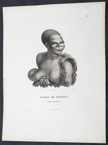
1807 Nicolas Baudin & N M Petit Antique Print of Tasmanian Aboriginal Arra Maida
- Title : Terre De Diemen Arra Maida
- Size: 13in x 10in (330mm x 255mm)
- Condition: (A+) Fine Condition
- Date : 1807
- Ref #: 93085
Description:
This exquisite, rare original copper-plate engraved antique print of Tasmanian Aboriginal Arra Maida, visited by the Baudin Expedition to Australia in Feb. 1802, was engraved by Barthélemy Roger, after Nicolas-Martin Petit (the offical artist on the ship Géographe) and was published by Francois Peron (1775 - 1810) in the 1st edition atlas of Nicolas Thomas Baudins expedition to Australia Voyage de découvertes aux Terres Australes
Nicholas Martin Petit sailed with Nicolas Baudin on the expedition of the Géographe and the Naturaliste in late 1800. The scientific field of anthropology was in its infancy – the French had founded the Society of the Observers of Man in 1799. Having embarked as a fourth-class gunner’s mate, Petit, who had had some graphic arts training, became one of the expeditions two illustrators when the official artists quit. From June to November 1802, the expedition was delayed in Sydney while its two ships were repaired. During this time Petit completed portraits of people of the Cadigal, Dharawal, Gweagal, Kurringai and Darug language groups of the Sydney Harbour region. While the sitters names appear to be noted on the works, it is possible that the inscriptions merely reflect French misinterpretation of the Aborigines communications with them.
The portrait of Nourou-gal-derri is pictured advancing for battle.
General Definitions:
Paper thickness and quality: - Heavy and stable
Paper color : - off white
Age of map color: -
Colors used: -
General color appearance: -
Paper size: - 14in x 10in (355mm x 255mm)
Plate size: - 14in x 10in (355mm x 255mm)
Margins: - Min 1/2in (12mm)
Imperfections:
Margins: - None
Plate area: - None
Verso: - None
Background:
The Baudin Expedition of 1800 to 1803 was a French expedition to map the coast of New Holland, Australia. The expedition started with two ships, Géographe, captained by Baudin, and Naturaliste captained by Jacques Hamelin, and was accompanied by nine zoologists and botanists, including Jean-Baptiste Leschenault de la Tour, François Péron and Charles-Alexandre Lesueur as well as the geographer Pierre Faure.
The Baudin expedition departed Le Havre, France, on 19 October 1800. Because of delays in receiving his instructions and problems encountered in Isle de France (now Mauritius) they did not reach Cape Leeuwin on the south-west corner of Australia until May 1801. Upon rounding Cape Naturaliste, they entered Geographe Bay. They then sailed north, but the ships became separated and did not meet again until they reached Timor. On their journeys the Géographe and the Naturaliste surveyed large stretches of the north-western coast. The expedition was severely affected by dysentery and fever, but sailed from Timor on 13 November 1801, back down the north-west and west coast, then across the Great Australian Bight, reaching Tasmania on 13 January 1802. They charted the whole length of Tasmanias east coast and there were extensive interactions with the Indigenous Tasmanians, with whom they had peaceful relationships. They notably produced precious ethnological studies of Indigenous Tasmanians.
The expedition then began surveying the south coast of Australia, but then Captain Jacques Felix Emmanuel Hamelin in Naturaliste decided to make for Port Jackson (Sydney) as he was running short of food and water, and in need of anchors. En route, in April 1802, Hamelin explored the area of Western Port, Victoria, and gave names to places, a number of which have survived, for example, Ile des Français is now called French Island.
Meanwhile, Baudin in the Géographe continued westward, and in April 1802 encountered the British ship Investigator commanded by Matthew Flinders, also engaged in charting the coastline, at Encounter Bay in what is now South Australia. Flinders informed Baudin of his discovery of Kangaroo Island, St. Vincents and Spencers Gulfs. Baudin sailed on to the Nuyts Archipelago, the point reached by t Gulden Zeepaert in 1627 before heading for Port Jackson as well for supplies.
In late 1802 the expedition was at Port Jackson, where the government sold 60 casks of flour and 25 casks of salt meat to Baudin to resupply his two vessels. The supplies permitted Naturaliste to return to France and Géographe to continue her explorations of the Australian coast. Naturaliste took with her the Colonys staff surgeon, Mr. James Thomson, whom Governor Philip Gidley King had given permission to return to England.
Before resuming the voyage Baudin purchased a 30 ton schooner, which he named the Casuarina, a smaller vessel which could conduct close inshore survey work. He sent the larger Naturaliste under Hamelin back to France with all the specimens that had been collected by Baudin and his crew. As the voyage had progressed Louis de Freycinet, now a Lieutenant, had shown his talents as an officer and a hydrographer and so was given command of the Casuarina. The expedition then headed for Tasmania and conducted further charting of Bass Strait before sailing west, following the west coast northward, and after another visit to Timor, undertook further exploration along the north coast of Australia. Plagued by contrary winds, ill health, and because the quadrupeds and emus were very sick, it was decided on 7 July 1803 to return to France. On the return voyage, the ships stopped in Mauritius, where Baudin died of tuberculosis on 16 September 1803. The expedition finally reached France on 24 March 1804.
The scientific expedition was considered a great success, with more than 2500 new species discovered.
Nicolas-Martin Petit 1777 – 1804
Nicholas-Martin Petit was born in Paris, the son of a fan maker, and learned graphic art in the studio of Jacques Louis David. He avoided conscription into Napoleons armies, but wanting to travel, signed up with post Captain Nicholas Baudin on a voyage to the antipodes sponsored by the French government. Petit and fellow artist Charles-Alexandre Lesueur were enlisted directly by Baudin (as 4th class gunners mates) while the two official artists were hired by the organisers of the expedition. Baudin set off in two lavishly equipped vessels, the Géographe and the Naturaliste on 19 October 1800. By the time the expedition reached Mauritius the official artists had quit. Petit and Lesueur took over their duties, but as neither was trained in scientific method or presentation, the value of their work was primarily aesthetic. The French were at this time developing a new scientific field - anthropology. The Society of the Observers of Man was founded in 1799 for this purpose. The study of Man formed part of the background for Petits sensitive drawings and paintings of the indigenous people of Van Diemens Land, Port Jackson and Western Australia. Lesueur focused on the depiction of animals. The expedition charted the coast of Western Australia and Van Diemens land but was plagued by scurvy. On 20 June 1802 the two ships limped into Port Jackson and stayed for five months to refit, during which time Petit completed a number of portraits of Sydney Indigenous people, including the two images of the Eora men, Cour-rou-bari-gal and Y-erren-gou-la-ga. Petit eventually returned to France in 1804. However, before he was well enough to complete the drawings from the expedition he was hurt in a street accident, and he died at the age of 28. Petits unfinished work was first published in 1807 in the Atlas of the Voyage de découvertes aux terres australes and as discrete prints.
Baudin, Nicolas Thomas 1754 – 1803
Baudin was a French explorer, cartographer, naturalist and hydrographer. Born a commoner in Saint-Martin-de-Ré on the Île de Ré on 17 February 1754 Baudin joined the merchant navy at the age of 15 and the French East India Company at the age of 20.
Baudin then joined the La Marine Royale (French Navy) in 1774 and served in the Caribbean as an officier bleu during the American War of Independence of 1775–1783.
In 1785 Baudin and his brother Alexandre were respectively masters of the St Remy and Caroline, taking Acadian settlers from Nantes to La Nouvelle Orléans. In New Orleans local merchants contracted him to take a cargo of wood, salted meat, cod and flour to Isle de France (now Mauritius), which he did in Josephine (also called Pepita), departing New Orleans on 14 July 1786 and arriving at Isle de France on 27 March 1787. In the course of the voyage, Josephine had called at Cap‑Français in Haiti to make a contract to transport slaves there from Madagascar; while in Haiti he also encountered the Austrian botanist Franz Josef Maerter, who apparently informed him that another Austrian botanist, Franz Boos, was at the Cape of Good Hope awaiting a ship to take him to Mauritius. Josephine called at the Cape and took Boos on board. At Mauritius, Boos chartered Baudin to transport him and the collection of plant specimens he had gathered there and at the Cape back to Europe, which Baudin did, Josephine arriving at Trieste on 18 June 1788. The Imperial government in Vienna was contemplating organizing another natural-history expedition, to which Boos would be appointed, in which two ships would be sent to the Malabar and Coromandel coasts of India, the Persian Gulf, Bengal, Ceylon, Sumatra, Java, Borneo, Cochin China, Tongking, Japan and China. Baudin had been given reason to hope that he would be given command of the ships of this expedition.
Later in 1788 Baudin sailed on a commercial voyage from Trieste to Canton in Jardiniere. He apparently arrived at Canton from Mauritius under the flag of the United States of America, probably to avoid the possibility of having his ship seized by the Chinese for payment of the debts owed them by the Imperial Asiatic Company of Trieste. From there, he sent Jardiniere under her second captain on a fur-trading venture to the north-west coast of America, but the ship foundered off Asuncion Island in the Marianas in late 1789.
Baudin made his way to Mauritius, where he purchased a replacement ship, Jardiniere II, but this vessel was wrecked in a cyclone that struck Port Louis on 15 December 1789. Baudin embarked on the Spanish Royal Philippines Company ship, Placeres, which sailed from Port Louis for Cadiz in August 1790. Placeres called at the Cape of Good Hope where it took on board the large number of plant and animal specimens collected in South Africa for the Imperial palace at Schönbrunn by Georg Scholl, the assistant of Franz Boos. Because of the poor condition of the ship, Placeres had to put in at the island of Trinidad in the West Indies, where Scholls collection of specimens was deposited.
Baudin proceeded to Martinique, from where he addressed an offer to the Imperial government in Vienna to conduct to Canton commissioners who would be empowered to negotiate with the Chinese merchants there a settlement of the debts incurred by the Imperial Asiatic Company, which would enable the company to renew its trade with China. On its return voyage from Canton, the proposed expedition would call at the Cape of Good Hope to pick up Scholl and the remainder of his natural-history collection for conveyance to Schönbrunn.
After returning to Vienna in September 1791, Baudin continued to press his case for an expedition under the Imperial flag to the Indian Ocean and China, and in January 1792 he was granted a commission of captain in the Imperial navy for this purpose. A ship, called Jardiniere, was acquired and the botanists Franz Bredemeyer and Joseph van der Schot appointed to the expedition. After delays caused by the outbreak of war between France and Austria (April 1792), Jardiniere departed from the Spanish port of Málaga on 1 October 1792. From the Cape of Good Hope Jardiniere sailed across the Indian Ocean to the coast of New Holland (Australia), but two consecutive cyclones prevented the expedition from doing any work there and forced Baudin to take the ship to Bombay for repairs.
From Bombay the expedition proceeded to the Persian Gulf, the Red Sea and the east coast of Africa, where it gathered botanical and zoological collections. The expedition came to an abrupt end in June 1794 when Jardiniere went aground in a storm while attempting to enter Table Bay at the Cape of Good Hope. Baudin survived the wreck and made his way to the United States, from where he went to France. He managed to send Jardinieres cargo of natural history specimens to the island of Trinidad.
In Paris, Baudin visited Antoine de Jussieu at the Museum National dHistoire Naturelle in March 1796 to suggest a botanical voyage to the Caribbean, during which he would recover the collection of specimens he had left in Trinidad. The Museum and the French government accepted the proposal, and Baudin was appointed commander of an expedition in the ship Belle Angélique, with four assigned botanists: René Maugé, André Pierre Ledru, Anselme Riedlé and Stanislas Levillain. Belle Angélique cleared Le Havre on 30 September 1796 for the Canary Islands, where the ship was condemned as unseaworthy. The expedition sailed from the Canaries in a replacement vessel, Fanny, and reached Trinidad in April 1797. The British, who had just captured the island from the Spanish in February 1797, refused to allow Baudin to recover the collection of natural-history specimens. Baudin took Fanny to St. Thomas and St. Croix, and then to Puerto Rico, specimens being collected in all three islands. At St Croix, Fanny was replaced by a newly purchased ship, renamed Belle Angelique. The expedition returned to France in June 1798 with a large collection of plants, birds and insects, which was incorporated into Napoleon Bonapartes triumphal procession celebrating his recent Italian victories.
On 24 July 1798, at the suggestion of the Ministry of Marine, Baudin presented to the Assembly of Professors and Administrators of the National Museum of Natural History a plan for a hydrographic-survey expedition to the South Seas, which would include a search for fauna and flora that could be brought back for cultivation in France. The expedition would also have the aim of promoting the economic and commercial interests of France in the regions to be visited. The expedition would require two well-equipped ships, which would carry a team of astronomers, naturalists and scientific draughtsmen over whom Baudin as commander would have absolute authority. The first part of the voyage would be devoted to a thorough exploration of the coast of Chile and the collection of animal, bird and plant specimens suitable for acclimatization in France, followed by a survey of the coasts from Peru to Mexico. The expedition would then continue into the Pacific Ocean, including a visit to Tahiti and the Society Islands, and would be completed with a survey of the yet unexplored south-west coast of New Holland (Australia). After considering this extensive proposal, the French government decided to proceed with an expedition confined to a survey of western and southern New Holland (as Australia was called at the time).
In October 1800 Baudin was selected to lead what has become known as the Baudin expedition to map the coast of Australia (New Holland). He had two ships, Géographe and Naturaliste captained by Hamelin, and a suite of nine zoologists and botanists, including Jean Baptiste Leschenault de la Tour. He reached Australia in May 1801, and would explore and map the western coast and a part of the little-known southern coast of the continent. The scientific expedition proved a great success, with more than 2500 new species discovered. The French also met Aboriginal peoples and treated them with great respect.
In April 1802 Baudin met Matthew Flinders, also engaged in charting the coastline, in Encounter Bay in present-day South Australia. Baudin then stopped at the British colony at Sydney for supplies. In Sydney he bought a new ship — Casuarina — named after the wood it was made from. From there he sent home Naturaliste, which had on board all of the specimens that had been discovered by Baudin and his crew. He then headed for Tasmania, before continuing north to Timor. Baudin then sailed for home, stopping at Mauritius.
According to recent researches by academics from the University of Adelaide, during Baudins expedition, François Péron, who had become the chief zoologist and intellectual leader of the mission, wrote a report for Napoleon on ways to invade and capture the British colony at Sydney Cove.
Baudin died of tuberculosis at Mauritius on 16 September 1803, at the age of 49, apparently in the home of Madame Alexandrine Kerivel. Baudins exact resting place is not known, but the historian Auguste Toussaint believed that he was interred in the Kerivel family vault. However, the historian Edward Duyker likes to think that Baudin was buried in Le Cimetière de lOuest in the district of Port Louis just a few hundred metres from the explorers certain love: the sea.
Please note all items auctioned are genuine, we do not sell reproductions. A Certificate of Authenticity (COA) can be issued on request.
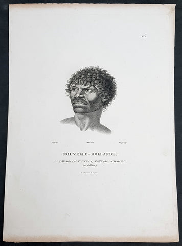
1807 Baudin & Petit Antique Print Sydney Aboriginal Gnung-a Gnung-a Murremurgan - Bennelong
- Title : Nouvelle-Hollande. Gnoung-a-gnoung-a Mour-re-mour-ga (dit Collins)
- Size: 14in x 10in (355mm x 255mm)
- Condition: (A+) Fine Condition
- Date : 1807
- Ref #: 91239
Description:
This exquisite, rare original copper-plate engraved antique print, of the brother in law of the famous Port Jackson Aborginal leader Bennelong, Gnung-a Gnung-a Murremurgan, or Anganángan, was engraved by Barthélemy Roger, after the 1802 by Nicolas-Martin Petit, was published by Francois Peron (1775 - 1810) in the 1st edition atlas of Nicolas Thomas Baudins expedition to Australia Voyage de découvertes aux Terres Australes
Gnung-a Gnung-a Murremurgan
It is over 200 years since the death of an adventurous young Aboriginal Australian who crossed the vast Pacific Ocean to North America and returned to Sydney. From the deck of an English storeship he glimpsed many strange places, visiting Norfolk Island, Hawaii, Nootka Sound (now Vancouver, Canada) and the Spanish colonies of San Francisco, Santa Barbara and San Diego on the Californian coast.
The voyager was Gnung-a Gnung-a Murremurgan, whose wife Warreeweer was the younger sister of the Wangal leader Woollarawarre Bennelong, at that time being feted in London society. The distance Gnung-a Gnung-a traversed was some 16,000 miles (25,750 kilometres) as the crow flies, but much further in a sailing ship driven by unpredictable winds.
On the first day he ventured into the convict settlement at Sydney Cove, in November 1790, Gnung-a Gnung-a adopted the name Collins from Acting Judge Advocate David Collins, who often mentions him in An Account of the English Colony in New South Wales, published in London in 1798.
It was the idea of Major Francis Grose, acting governor of New South Wales after the departure of Captain Arthur Phillip in 1792, to embark a native of this country on HM storeship Daedalus for the purpose of acquiring our language, wrote David Collins. The 350-ton capacity vessel was ordered to resupply provisions for the expedition to the north-west coast of North America commanded by Captain George Vancouver (1757–1798). In the navy ships HMS Discovery and HMS Chatham, Captain Vancouver was to complete the survey made by Captain James Cook.
Voyage to America
HMS Daedalus sailed from Port Jackson on 1 July 1793, passing west of the Society Islands (French Polynesia) to Owhyee (Hawaii). The commander, Lieutenant James Hanson, missed a rendezvous with Vancouvers ships at Nootka Sound on 8 October, but anchored with the two survey ships off San Francisco Bay on 21 October. The three British ships followed the coast of todays California to San Diego, leaving on 9 December 1793 and arriving at Hilo in Hawaii on 8 January 1794.
The Hawaiian King Kamehameha, who warmly welcomed Vancouver, was so impressed by the good-natured, handsome Aboriginal man on the expedition that he wanted to buy him, offering in exchange canoes, weapons and curiosities.
Gnung-a Gnung-a got on well with everyone on Daedalus and Hanson was pleased by his good nature and his willingness to do whatever was asked of him. During his month in Hawaii, he often went ashore with his shipmates. Wherever he went he readily adopted the manners of those around him, Hanson later told Collins, who remarked, with ironic humour, that...........
when at Owhyee, having discovered that favours from the females were to be procured at the easy exchange for a looking-glass, a nail, or a knife, he was not backward in presenting his little offering, and was as well received as any of the white people in the ship. It was noticed too that he always displayed some taste in selecting the object of his attentions.......
Return to Sydney
Home in Sydney Town, Gnung-a Gnung-a fought and wounded a very fine young fellow called Wyatt, who had taken up with his wife during his absence and Warreeweer became the prize of the victor.
During a ritual revenge combat in December 1795, Pemulwuy, leader of the Georges River Bidjigal near Botany Bay, launched a spear at Gnung-a Gnung-a that remained fixed in his back. The English surgeons could not extract the spear and thought he was unlikely to recover. Gnung-a Gnung-a, however, left the hospital and walked about for several weeks with the spear protruding from his back. At last, wrote Collins in a footnote..........
we heard that his wife, or one of his male friends, had fixed their teeth in the wood and drawn it out after which he recovered, and was able again to go into the field. His wife War-re-weer showed by an uncommon attention her great attachment to him.......
Before this unexpected recovery, David Collins wrote a brief appreciation of his namesake:
He was much esteemed by every white man who knew him, as well on account of his personal bravery, of which we had witnessed many distinguishing proofs, as on account of a gentleness of manners which strongly marked his disposition, and shaded off the harsher lines that his uncivilised life now and then forced into the fore-ground.
While in Sydney with a scientific expedition commanded by Nicholas Baudin in 1802, the young French artist Nicolas-Martin Petit met Gnung-a Gnung-a and sketched a striking portrait that he captioned Gnoung-a gnoung-a, mour-re-mour-ga (dit Collins)
A report in the Sydney Gazette of Sunday 15 January 1809 said that the body of Collins (Gnung-a Gnung-a Murremurgan) had been found beside the Dry Store, site of the present Sirius Park in Bridge Street, Sydney. The newspaper said he had been known for the docility of his temper, and the high estimation in which he was universally held among the native tribes.
On the night of Thursday 12 January 1809, Gnung-a Gnung-as children, others he had adopted, and his brother Old Phillip, faced a salvo of spears in the ritual ordeal that followed death in Aboriginal society. The date of his death was not recorded, but it was customary to keep an overnight vigil over a dead body before burial and the subsequent revenge combat, so it was probably 11 January.
Gnung-a Gnung-a Murremurgan is one of many Aboriginal men and women who sailed from Sydney in English ships and played a significant role in Australias early maritime history.
General Definitions:
Paper thickness and quality: - Heavy and stable
Paper color : - off white
Age of map color: -
Colors used: -
General color appearance: -
Paper size: - 14in x 10in (355mm x 255mm)
Plate size: - 12 1/2in x 9 1/2in (320mm x 240mm)
Margins: - Min 1/2in (12mm)
Imperfections:
Margins: - Light age toning to outer margins
Plate area: - None
Verso: - None
Background:
The Baudin Expedition of 1800 to 1803 was a French expedition to map the coast of New Holland, Australia. The expedition started with two ships, Géographe, captained by Baudin, and Naturaliste captained by Jacques Hamelin, and was accompanied by nine zoologists and botanists, including Jean-Baptiste Leschenault de la Tour, François Péron and Charles-Alexandre Lesueur as well as the geographer Pierre Faure.
The Baudin expedition departed Le Havre, France, on 19 October 1800. Because of delays in receiving his instructions and problems encountered in Isle de France (now Mauritius) they did not reach Cape Leeuwin on the south-west corner of Australia until May 1801. Upon rounding Cape Naturaliste, they entered Geographe Bay. They then sailed north, but the ships became separated and did not meet again until they reached Timor. On their journeys the Géographe and the Naturaliste surveyed large stretches of the north-western coast. The expedition was severely affected by dysentery and fever, but sailed from Timor on 13 November 1801, back down the north-west and west coast, then across the Great Australian Bight, reaching Tasmania on 13 January 1802. They charted the whole length of Tasmanias east coast and there were extensive interactions with the Indigenous Tasmanians, with whom they had peaceful relationships. They notably produced precious ethnological studies of Indigenous Tasmanians.
The expedition then began surveying the south coast of Australia, but then Captain Jacques Felix Emmanuel Hamelin in Naturaliste decided to make for Port Jackson (Sydney) as he was running short of food and water, and in need of anchors. En route, in April 1802, Hamelin explored the area of Western Port, Victoria, and gave names to places, a number of which have survived, for example, Ile des Français is now called French Island.
Meanwhile, Baudin in the Géographe continued westward, and in April 1802 encountered the British ship Investigator commanded by Matthew Flinders, also engaged in charting the coastline, at Encounter Bay in what is now South Australia. Flinders informed Baudin of his discovery of Kangaroo Island, St. Vincents and Spencers Gulfs. Baudin sailed on to the Nuyts Archipelago, the point reached by t Gulden Zeepaert in 1627 before heading for Port Jackson as well for supplies.
In late 1802 the expedition was at Port Jackson, where the government sold 60 casks of flour and 25 casks of salt meat to Baudin to resupply his two vessels. The supplies permitted Naturaliste to return to France and Géographe to continue her explorations of the Australian coast. Naturaliste took with her the Colonys staff surgeon, Mr. James Thomson, whom Governor Philip Gidley King had given permission to return to England.
Before resuming the voyage Baudin purchased a 30 ton schooner, which he named the Casuarina, a smaller vessel which could conduct close inshore survey work. He sent the larger Naturaliste under Hamelin back to France with all the specimens that had been collected by Baudin and his crew. As the voyage had progressed Louis de Freycinet, now a Lieutenant, had shown his talents as an officer and a hydrographer and so was given command of the Casuarina. The expedition then headed for Tasmania and conducted further charting of Bass Strait before sailing west, following the west coast northward, and after another visit to Timor, undertook further exploration along the north coast of Australia. Plagued by contrary winds, ill health, and because the quadrupeds and emus were very sick, it was decided on 7 July 1803 to return to France. On the return voyage, the ships stopped in Mauritius, where Baudin died of tuberculosis on 16 September 1803. The expedition finally reached France on 24 March 1804.
The scientific expedition was considered a great success, with more than 2500 new species discovered.
Nicolas-Martin Petit 1777 – 1804
Nicholas-Martin Petit was born in Paris, the son of a fan maker, and learned graphic art in the studio of Jacques Louis David. He avoided conscription into Napoleons armies, but wanting to travel, signed up with post Captain Nicholas Baudin on a voyage to the antipodes sponsored by the French government. Petit and fellow artist Charles-Alexandre Lesueur were enlisted directly by Baudin (as 4th class gunners mates) while the two official artists were hired by the organisers of the expedition. Baudin set off in two lavishly equipped vessels, the Géographe and the Naturaliste on 19 October 1800. By the time the expedition reached Mauritius the official artists had quit. Petit and Lesueur took over their duties, but as neither was trained in scientific method or presentation, the value of their work was primarily aesthetic. The French were at this time developing a new scientific field - anthropology. The Society of the Observers of Man was founded in 1799 for this purpose. The study of Man formed part of the background for Petits sensitive drawings and paintings of the indigenous people of Van Diemens Land, Port Jackson and Western Australia. Lesueur focused on the depiction of animals. The expedition charted the coast of Western Australia and Van Diemens land but was plagued by scurvy. On 20 June 1802 the two ships limped into Port Jackson and stayed for five months to refit, during which time Petit completed a number of portraits of Sydney Indigenous people, including the two images of the Eora men, Cour-rou-bari-gal and Y-erren-gou-la-ga. Petit eventually returned to France in 1804. However, before he was well enough to complete the drawings from the expedition he was hurt in a street accident, and he died at the age of 28. Petits unfinished work was first published in 1807 in the Atlas of the Voyage de découvertes aux terres australes and as discrete prints.
Baudin, Nicolas Thomas 1754 – 1803
Baudin was a French explorer, cartographer, naturalist and hydrographer. Born a commoner in Saint-Martin-de-Ré on the Île de Ré on 17 February 1754 Baudin joined the merchant navy at the age of 15 and the French East India Company at the age of 20.
Baudin then joined the La Marine Royale (French Navy) in 1774 and served in the Caribbean as an officier bleu during the American War of Independence of 1775–1783.
In 1785 Baudin and his brother Alexandre were respectively masters of the St Remy and Caroline, taking Acadian settlers from Nantes to La Nouvelle Orléans. In New Orleans local merchants contracted him to take a cargo of wood, salted meat, cod and flour to Isle de France (now Mauritius), which he did in Josephine (also called Pepita), departing New Orleans on 14 July 1786 and arriving at Isle de France on 27 March 1787. In the course of the voyage, Josephine had called at Cap‑Français in Haiti to make a contract to transport slaves there from Madagascar; while in Haiti he also encountered the Austrian botanist Franz Josef Maerter, who apparently informed him that another Austrian botanist, Franz Boos, was at the Cape of Good Hope awaiting a ship to take him to Mauritius. Josephine called at the Cape and took Boos on board. At Mauritius, Boos chartered Baudin to transport him and the collection of plant specimens he had gathered there and at the Cape back to Europe, which Baudin did, Josephine arriving at Trieste on 18 June 1788. The Imperial government in Vienna was contemplating organizing another natural-history expedition, to which Boos would be appointed, in which two ships would be sent to the Malabar and Coromandel coasts of India, the Persian Gulf, Bengal, Ceylon, Sumatra, Java, Borneo, Cochin China, Tongking, Japan and China. Baudin had been given reason to hope that he would be given command of the ships of this expedition.
Later in 1788 Baudin sailed on a commercial voyage from Trieste to Canton in Jardiniere. He apparently arrived at Canton from Mauritius under the flag of the United States of America, probably to avoid the possibility of having his ship seized by the Chinese for payment of the debts owed them by the Imperial Asiatic Company of Trieste. From there, he sent Jardiniere under her second captain on a fur-trading venture to the north-west coast of America, but the ship foundered off Asuncion Island in the Marianas in late 1789.
Baudin made his way to Mauritius, where he purchased a replacement ship, Jardiniere II, but this vessel was wrecked in a cyclone that struck Port Louis on 15 December 1789. Baudin embarked on the Spanish Royal Philippines Company ship, Placeres, which sailed from Port Louis for Cadiz in August 1790. Placeres called at the Cape of Good Hope where it took on board the large number of plant and animal specimens collected in South Africa for the Imperial palace at Schönbrunn by Georg Scholl, the assistant of Franz Boos. Because of the poor condition of the ship, Placeres had to put in at the island of Trinidad in the West Indies, where Scholls collection of specimens was deposited.
Baudin proceeded to Martinique, from where he addressed an offer to the Imperial government in Vienna to conduct to Canton commissioners who would be empowered to negotiate with the Chinese merchants there a settlement of the debts incurred by the Imperial Asiatic Company, which would enable the company to renew its trade with China. On its return voyage from Canton, the proposed expedition would call at the Cape of Good Hope to pick up Scholl and the remainder of his natural-history collection for conveyance to Schönbrunn.
After returning to Vienna in September 1791, Baudin continued to press his case for an expedition under the Imperial flag to the Indian Ocean and China, and in January 1792 he was granted a commission of captain in the Imperial navy for this purpose. A ship, called Jardiniere, was acquired and the botanists Franz Bredemeyer and Joseph van der Schot appointed to the expedition. After delays caused by the outbreak of war between France and Austria (April 1792), Jardiniere departed from the Spanish port of Málaga on 1 October 1792. From the Cape of Good Hope Jardiniere sailed across the Indian Ocean to the coast of New Holland (Australia), but two consecutive cyclones prevented the expedition from doing any work there and forced Baudin to take the ship to Bombay for repairs.
From Bombay the expedition proceeded to the Persian Gulf, the Red Sea and the east coast of Africa, where it gathered botanical and zoological collections. The expedition came to an abrupt end in June 1794 when Jardiniere went aground in a storm while attempting to enter Table Bay at the Cape of Good Hope. Baudin survived the wreck and made his way to the United States, from where he went to France. He managed to send Jardinieres cargo of natural history specimens to the island of Trinidad.
In Paris, Baudin visited Antoine de Jussieu at the Museum National dHistoire Naturelle in March 1796 to suggest a botanical voyage to the Caribbean, during which he would recover the collection of specimens he had left in Trinidad. The Museum and the French government accepted the proposal, and Baudin was appointed commander of an expedition in the ship Belle Angélique, with four assigned botanists: René Maugé, André Pierre Ledru, Anselme Riedlé and Stanislas Levillain. Belle Angélique cleared Le Havre on 30 September 1796 for the Canary Islands, where the ship was condemned as unseaworthy. The expedition sailed from the Canaries in a replacement vessel, Fanny, and reached Trinidad in April 1797. The British, who had just captured the island from the Spanish in February 1797, refused to allow Baudin to recover the collection of natural-history specimens. Baudin took Fanny to St. Thomas and St. Croix, and then to Puerto Rico, specimens being collected in all three islands. At St Croix, Fanny was replaced by a newly purchased ship, renamed Belle Angelique. The expedition returned to France in June 1798 with a large collection of plants, birds and insects, which was incorporated into Napoleon Bonapartes triumphal procession celebrating his recent Italian victories.
On 24 July 1798, at the suggestion of the Ministry of Marine, Baudin presented to the Assembly of Professors and Administrators of the National Museum of Natural History a plan for a hydrographic-survey expedition to the South Seas, which would include a search for fauna and flora that could be brought back for cultivation in France. The expedition would also have the aim of promoting the economic and commercial interests of France in the regions to be visited. The expedition would require two well-equipped ships, which would carry a team of astronomers, naturalists and scientific draughtsmen over whom Baudin as commander would have absolute authority. The first part of the voyage would be devoted to a thorough exploration of the coast of Chile and the collection of animal, bird and plant specimens suitable for acclimatization in France, followed by a survey of the coasts from Peru to Mexico. The expedition would then continue into the Pacific Ocean, including a visit to Tahiti and the Society Islands, and would be completed with a survey of the yet unexplored south-west coast of New Holland (Australia). After considering this extensive proposal, the French government decided to proceed with an expedition confined to a survey of western and southern New Holland (as Australia was called at the time).
In October 1800 Baudin was selected to lead what has become known as the Baudin expedition to map the coast of Australia (New Holland). He had two ships, Géographe and Naturaliste captained by Hamelin, and a suite of nine zoologists and botanists, including Jean Baptiste Leschenault de la Tour. He reached Australia in May 1801, and would explore and map the western coast and a part of the little-known southern coast of the continent. The scientific expedition proved a great success, with more than 2500 new species discovered. The French also met Aboriginal peoples and treated them with great respect.
In April 1802 Baudin met Matthew Flinders, also engaged in charting the coastline, in Encounter Bay in present-day South Australia. Baudin then stopped at the British colony at Sydney for supplies. In Sydney he bought a new ship — Casuarina — named after the wood it was made from. From there he sent home Naturaliste, which had on board all of the specimens that had been discovered by Baudin and his crew. He then headed for Tasmania, before continuing north to Timor. Baudin then sailed for home, stopping at Mauritius.
According to recent researches by academics from the University of Adelaide, during Baudins expedition, François Péron, who had become the chief zoologist and intellectual leader of the mission, wrote a report for Napoleon on ways to invade and capture the British colony at Sydney Cove.
Baudin died of tuberculosis at Mauritius on 16 September 1803, at the age of 49, apparently in the home of Madame Alexandrine Kerivel. Baudins exact resting place is not known, but the historian Auguste Toussaint believed that he was interred in the Kerivel family vault. However, the historian Edward Duyker likes to think that Baudin was buried in Le Cimetière de lOuest in the district of Port Louis just a few hundred metres from the explorers certain love: the sea.
Please note all items auctioned are genuine, we do not sell reproductions. A Certificate of Authenticity (COA) can be issued on request.
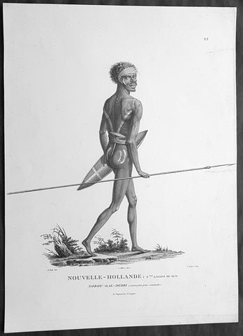
1807 Baudin & Petit Antique Print of a Sydney & Port Jackson Aboriginal Warrior
- Title : Nouvelle-Hollande. Nelle Galles Du Sud. Nourou-gal-derri & avancant pour combattre
- Size: 14in x 10in (355mm x 255mm)
- Condition: (A+) Fine Condition
- Date : 1807
- Ref #: 91240
Description:
This exquisite, rare original copper-plate engraved antique print of an Aboriginal warrior of Port Jackson carrying a spear & shield, was engraved by Barthélemy Roger, after the 1802 drawing by Nicolas-Martin Petit and was published by Francois Peron (1775 - 1810) in the 1st edition atlas of Nicolas Thomas Baudins expedition to Australia Voyage de découvertes aux Terres Australes in 1807.
This is a wonderful original stipple point engraving by Petit & Roger bringing to life this wonderful 1st Australian.
Nicholas Martin Petit sailed with Nicolas Baudin on the expedition of the Géographe and the Naturaliste in late 1800. The scientific field of anthropology was in its infancy – the French had founded the Society of the Observers of Man in 1799. Having embarked as a fourth-class gunner’s mate, Petit, who had had some graphic arts training, became one of the expeditions two illustrators when the official artists quit. From June to November 1802, the expedition was delayed in Sydney while its two ships were repaired. During this time Petit completed portraits of people of the Cadigal, Dharawal, Gweagal, Kurringai and Darug language groups of the Sydney Harbour region. While the sitters names appear to be noted on the works, it is possible that the inscriptions merely reflect French misinterpretation of the Aborigines communications with them.
The portrait of Nourou-gal-derri is pictured advancing for battle.
General Definitions:
Paper thickness and quality: - Heavy and stable
Paper color : - off white
Age of map color: -
Colors used: -
General color appearance: -
Paper size: - 14in x 10in (355mm x 255mm)
Plate size: - 12 1/2in x 9 1/2in (320mm x 240mm)
Margins: - Min 1/2in (12mm)
Imperfections:
Margins: - None
Plate area: - 2 small repair to left margin, no loss
Verso: - None
Background:
The Baudin Expedition of 1800 to 1803 was a French expedition to map the coast of New Holland, Australia. The expedition started with two ships, Géographe, captained by Baudin, and Naturaliste captained by Jacques Hamelin, and was accompanied by nine zoologists and botanists, including Jean-Baptiste Leschenault de la Tour, François Péron and Charles-Alexandre Lesueur as well as the geographer Pierre Faure.
The Baudin expedition departed Le Havre, France, on 19 October 1800. Because of delays in receiving his instructions and problems encountered in Isle de France (now Mauritius) they did not reach Cape Leeuwin on the south-west corner of Australia until May 1801. Upon rounding Cape Naturaliste, they entered Geographe Bay. They then sailed north, but the ships became separated and did not meet again until they reached Timor. On their journeys the Géographe and the Naturaliste surveyed large stretches of the north-western coast. The expedition was severely affected by dysentery and fever, but sailed from Timor on 13 November 1801, back down the north-west and west coast, then across the Great Australian Bight, reaching Tasmania on 13 January 1802. They charted the whole length of Tasmanias east coast and there were extensive interactions with the Indigenous Tasmanians, with whom they had peaceful relationships. They notably produced precious ethnological studies of Indigenous Tasmanians.
The expedition then began surveying the south coast of Australia, but then Captain Jacques Felix Emmanuel Hamelin in Naturaliste decided to make for Port Jackson (Sydney) as he was running short of food and water, and in need of anchors. En route, in April 1802, Hamelin explored the area of Western Port, Victoria, and gave names to places, a number of which have survived, for example, Ile des Français is now called French Island.
Meanwhile, Baudin in the Géographe continued westward, and in April 1802 encountered the British ship Investigator commanded by Matthew Flinders, also engaged in charting the coastline, at Encounter Bay in what is now South Australia. Flinders informed Baudin of his discovery of Kangaroo Island, St. Vincents and Spencers Gulfs. Baudin sailed on to the Nuyts Archipelago, the point reached by t Gulden Zeepaert in 1627 before heading for Port Jackson as well for supplies.
In late 1802 the expedition was at Port Jackson, where the government sold 60 casks of flour and 25 casks of salt meat to Baudin to resupply his two vessels. The supplies permitted Naturaliste to return to France and Géographe to continue her explorations of the Australian coast. Naturaliste took with her the Colonys staff surgeon, Mr. James Thomson, whom Governor Philip Gidley King had given permission to return to England.
Before resuming the voyage Baudin purchased a 30 ton schooner, which he named the Casuarina, a smaller vessel which could conduct close inshore survey work. He sent the larger Naturaliste under Hamelin back to France with all the specimens that had been collected by Baudin and his crew. As the voyage had progressed Louis de Freycinet, now a Lieutenant, had shown his talents as an officer and a hydrographer and so was given command of the Casuarina. The expedition then headed for Tasmania and conducted further charting of Bass Strait before sailing west, following the west coast northward, and after another visit to Timor, undertook further exploration along the north coast of Australia. Plagued by contrary winds, ill health, and because the quadrupeds and emus were very sick, it was decided on 7 July 1803 to return to France. On the return voyage, the ships stopped in Mauritius, where Baudin died of tuberculosis on 16 September 1803. The expedition finally reached France on 24 March 1804.
The scientific expedition was considered a great success, with more than 2500 new species discovered.
Nicolas-Martin Petit 1777 – 1804
Nicholas-Martin Petit was born in Paris, the son of a fan maker, and learned graphic art in the studio of Jacques Louis David. He avoided conscription into Napoleons armies, but wanting to travel, signed up with post Captain Nicholas Baudin on a voyage to the antipodes sponsored by the French government. Petit and fellow artist Charles-Alexandre Lesueur were enlisted directly by Baudin (as 4th class gunners mates) while the two official artists were hired by the organisers of the expedition. Baudin set off in two lavishly equipped vessels, the Géographe and the Naturaliste on 19 October 1800. By the time the expedition reached Mauritius the official artists had quit. Petit and Lesueur took over their duties, but as neither was trained in scientific method or presentation, the value of their work was primarily aesthetic. The French were at this time developing a new scientific field - anthropology. The Society of the Observers of Man was founded in 1799 for this purpose. The study of Man formed part of the background for Petits sensitive drawings and paintings of the indigenous people of Van Diemens Land, Port Jackson and Western Australia. Lesueur focused on the depiction of animals. The expedition charted the coast of Western Australia and Van Diemens land but was plagued by scurvy. On 20 June 1802 the two ships limped into Port Jackson and stayed for five months to refit, during which time Petit completed a number of portraits of Sydney Indigenous people, including the two images of the Eora men, Cour-rou-bari-gal and Y-erren-gou-la-ga. Petit eventually returned to France in 1804. However, before he was well enough to complete the drawings from the expedition he was hurt in a street accident, and he died at the age of 28. Petits unfinished work was first published in 1807 in the Atlas of the Voyage de découvertes aux terres australes and as discrete prints.
Baudin, Nicolas Thomas 1754 – 1803
Baudin was a French explorer, cartographer, naturalist and hydrographer. Born a commoner in Saint-Martin-de-Ré on the Île de Ré on 17 February 1754 Baudin joined the merchant navy at the age of 15 and the French East India Company at the age of 20.
Baudin then joined the La Marine Royale (French Navy) in 1774 and served in the Caribbean as an officier bleu during the American War of Independence of 1775–1783.
In 1785 Baudin and his brother Alexandre were respectively masters of the St Remy and Caroline, taking Acadian settlers from Nantes to La Nouvelle Orléans. In New Orleans local merchants contracted him to take a cargo of wood, salted meat, cod and flour to Isle de France (now Mauritius), which he did in Josephine (also called Pepita), departing New Orleans on 14 July 1786 and arriving at Isle de France on 27 March 1787. In the course of the voyage, Josephine had called at Cap‑Français in Haiti to make a contract to transport slaves there from Madagascar; while in Haiti he also encountered the Austrian botanist Franz Josef Maerter, who apparently informed him that another Austrian botanist, Franz Boos, was at the Cape of Good Hope awaiting a ship to take him to Mauritius. Josephine called at the Cape and took Boos on board. At Mauritius, Boos chartered Baudin to transport him and the collection of plant specimens he had gathered there and at the Cape back to Europe, which Baudin did, Josephine arriving at Trieste on 18 June 1788. The Imperial government in Vienna was contemplating organizing another natural-history expedition, to which Boos would be appointed, in which two ships would be sent to the Malabar and Coromandel coasts of India, the Persian Gulf, Bengal, Ceylon, Sumatra, Java, Borneo, Cochin China, Tongking, Japan and China. Baudin had been given reason to hope that he would be given command of the ships of this expedition.
Later in 1788 Baudin sailed on a commercial voyage from Trieste to Canton in Jardiniere. He apparently arrived at Canton from Mauritius under the flag of the United States of America, probably to avoid the possibility of having his ship seized by the Chinese for payment of the debts owed them by the Imperial Asiatic Company of Trieste. From there, he sent Jardiniere under her second captain on a fur-trading venture to the north-west coast of America, but the ship foundered off Asuncion Island in the Marianas in late 1789.
Baudin made his way to Mauritius, where he purchased a replacement ship, Jardiniere II, but this vessel was wrecked in a cyclone that struck Port Louis on 15 December 1789. Baudin embarked on the Spanish Royal Philippines Company ship, Placeres, which sailed from Port Louis for Cadiz in August 1790. Placeres called at the Cape of Good Hope where it took on board the large number of plant and animal specimens collected in South Africa for the Imperial palace at Schönbrunn by Georg Scholl, the assistant of Franz Boos. Because of the poor condition of the ship, Placeres had to put in at the island of Trinidad in the West Indies, where Scholls collection of specimens was deposited.
Baudin proceeded to Martinique, from where he addressed an offer to the Imperial government in Vienna to conduct to Canton commissioners who would be empowered to negotiate with the Chinese merchants there a settlement of the debts incurred by the Imperial Asiatic Company, which would enable the company to renew its trade with China. On its return voyage from Canton, the proposed expedition would call at the Cape of Good Hope to pick up Scholl and the remainder of his natural-history collection for conveyance to Schönbrunn.
After returning to Vienna in September 1791, Baudin continued to press his case for an expedition under the Imperial flag to the Indian Ocean and China, and in January 1792 he was granted a commission of captain in the Imperial navy for this purpose. A ship, called Jardiniere, was acquired and the botanists Franz Bredemeyer and Joseph van der Schot appointed to the expedition. After delays caused by the outbreak of war between France and Austria (April 1792), Jardiniere departed from the Spanish port of Málaga on 1 October 1792. From the Cape of Good Hope Jardiniere sailed across the Indian Ocean to the coast of New Holland (Australia), but two consecutive cyclones prevented the expedition from doing any work there and forced Baudin to take the ship to Bombay for repairs.
From Bombay the expedition proceeded to the Persian Gulf, the Red Sea and the east coast of Africa, where it gathered botanical and zoological collections. The expedition came to an abrupt end in June 1794 when Jardiniere went aground in a storm while attempting to enter Table Bay at the Cape of Good Hope. Baudin survived the wreck and made his way to the United States, from where he went to France. He managed to send Jardinieres cargo of natural history specimens to the island of Trinidad.
In Paris, Baudin visited Antoine de Jussieu at the Museum National dHistoire Naturelle in March 1796 to suggest a botanical voyage to the Caribbean, during which he would recover the collection of specimens he had left in Trinidad. The Museum and the French government accepted the proposal, and Baudin was appointed commander of an expedition in the ship Belle Angélique, with four assigned botanists: René Maugé, André Pierre Ledru, Anselme Riedlé and Stanislas Levillain. Belle Angélique cleared Le Havre on 30 September 1796 for the Canary Islands, where the ship was condemned as unseaworthy. The expedition sailed from the Canaries in a replacement vessel, Fanny, and reached Trinidad in April 1797. The British, who had just captured the island from the Spanish in February 1797, refused to allow Baudin to recover the collection of natural-history specimens. Baudin took Fanny to St. Thomas and St. Croix, and then to Puerto Rico, specimens being collected in all three islands. At St Croix, Fanny was replaced by a newly purchased ship, renamed Belle Angelique. The expedition returned to France in June 1798 with a large collection of plants, birds and insects, which was incorporated into Napoleon Bonapartes triumphal procession celebrating his recent Italian victories.
On 24 July 1798, at the suggestion of the Ministry of Marine, Baudin presented to the Assembly of Professors and Administrators of the National Museum of Natural History a plan for a hydrographic-survey expedition to the South Seas, which would include a search for fauna and flora that could be brought back for cultivation in France. The expedition would also have the aim of promoting the economic and commercial interests of France in the regions to be visited. The expedition would require two well-equipped ships, which would carry a team of astronomers, naturalists and scientific draughtsmen over whom Baudin as commander would have absolute authority. The first part of the voyage would be devoted to a thorough exploration of the coast of Chile and the collection of animal, bird and plant specimens suitable for acclimatization in France, followed by a survey of the coasts from Peru to Mexico. The expedition would then continue into the Pacific Ocean, including a visit to Tahiti and the Society Islands, and would be completed with a survey of the yet unexplored south-west coast of New Holland (Australia). After considering this extensive proposal, the French government decided to proceed with an expedition confined to a survey of western and southern New Holland (as Australia was called at the time).
In October 1800 Baudin was selected to lead what has become known as the Baudin expedition to map the coast of Australia (New Holland). He had two ships, Géographe and Naturaliste captained by Hamelin, and a suite of nine zoologists and botanists, including Jean Baptiste Leschenault de la Tour. He reached Australia in May 1801, and would explore and map the western coast and a part of the little-known southern coast of the continent. The scientific expedition proved a great success, with more than 2500 new species discovered. The French also met Aboriginal peoples and treated them with great respect.
In April 1802 Baudin met Matthew Flinders, also engaged in charting the coastline, in Encounter Bay in present-day South Australia. Baudin then stopped at the British colony at Sydney for supplies. In Sydney he bought a new ship — Casuarina — named after the wood it was made from. From there he sent home Naturaliste, which had on board all of the specimens that had been discovered by Baudin and his crew. He then headed for Tasmania, before continuing north to Timor. Baudin then sailed for home, stopping at Mauritius.
According to recent researches by academics from the University of Adelaide, during Baudins expedition, François Péron, who had become the chief zoologist and intellectual leader of the mission, wrote a report for Napoleon on ways to invade and capture the British colony at Sydney Cove.
Baudin died of tuberculosis at Mauritius on 16 September 1803, at the age of 49, apparently in the home of Madame Alexandrine Kerivel. Baudins exact resting place is not known, but the historian Auguste Toussaint believed that he was interred in the Kerivel family vault. However, the historian Edward Duyker likes to think that Baudin was buried in Le Cimetière de lOuest in the district of Port Louis just a few hundred metres from the explorers certain love: the sea.
Please note all items auctioned are genuine, we do not sell reproductions. A Certificate of Authenticity (COA) can be issued on request.
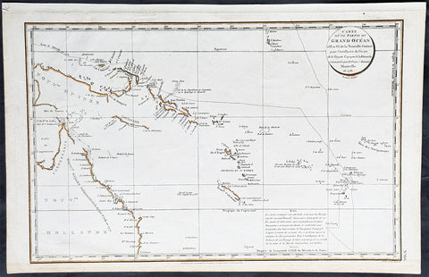
1798 Laperouse & Mourelle Antique Early Map of Queensland, PNG, Fiji etc in 1781
- Title : Carte D Une Partie Du Grand Ocean a l E. et S.E. de la Nouvelle Guinee pour l intelligence du Voyage de la Fregate Espagnole la Princesa commandee par D. Franco. Antonio Maurelle. en 1781..... Published as the (act) directs Novr. 1st 1798, by G.G. & J. Robinson
- Ref #: 31555
- Size: 16 3/4in x 11in (425mm x 280mm)
- Date : 1798
- Condition: (A+) Fine Condition
Description:
This large original copper plate engraved antique early map of Queensland, New Guinea, Fiji, French Polynesia & other South Pacific Islands - tracking the voyages of Francisco Antonio Mourelle in the region in 1781 was engraved in 1798 - dated - and was published in the 1st English edition of the Atlas du voyage de La Perouse G.G & J. Robinson, London in 1799.
La Perouse set sail from France in 1785 to continue the discoveries of Captain Cook. He was shipwrecked in 1788 but his narrative, maps, and views survived and were first published in 1797.
Interesting chart of Eastern Australia and part of the south-western Pacific, showing the routes taken by the Spanish explorer Don Francisco Antonio Maurelle in 1781 along the northern coast of New Guinea and across the Pacific to Fiji and Tonga, including a maunscript grid added in a contemporary hand.
Maurelle was credited with the discovery of the Hermit Islands on this voyage. The map includes the north-eastern coast of Australia, and parts of the coast of New Guinea. The map shows the 1781 route of his ship The Princesa through the Bismarck Archipelago north of New Guinea, through the Archipel de Salomos [i.e. Solomon Islands] and then east across the Pacific to the Iles de Amis [i.e. the Friendly Islands, now Tonga] where he discovered I. Vavao [ i.e. Vavau] with one of the best anchorages in the South Pacific.
The map includes the Iles de Navigateurs [i.e. Samoa], I. Fidji [i.e. Fiji], Iles de Esprit [i.e. Vanuatu or the New Hebrides Isles], and Nouvelle Caledonie [i.e. New Caledonia]. Many small islands are depicted with notes regarding their sightings by Abel Tasman, William Bligh and Maurelle.
A note on the chart states that the publisher has placed the islands according to the longitude of other navigators, rather than on Maurelles figures which were considered estimates only, and also, that Maurelles chart was based on a French chart by Jacques Nicolas Bellin published in 1742.
General Definitions:
Paper thickness and quality: - Heavy and stable
Paper color : - off white
Age of map color: - Early
Colors used: - Yellow
General color appearance: - Authentic
Paper size: - 16 3/4in x 11in (425mm x 280mm)
Plate size: - 16in x 10in (405mm x 255mm)
Margins: - Min 1/2in (12mm)
Imperfections:
Margins: - Light age toning in margins
Plate area: - None
Verso: - None
Background:
Mourelle de la Rúa, Francisco Antonio 1750 – 1820
Mourelle was a Galician naval officer and explorer serving the Spanish crown. He was born in 1750 at San Adrián de Corme (Corme Aldea, Ponteceso), near La Coruña, Galicia
1775 voyage Mourelle served the Spanish navy in the Guyanas, Trinidad, and the Antilles before becoming stationed at New Spain\'s Pacific Ocean naval base at San Blas, Mexico in 1774. He joined the 1775 expedition of Bruno de Heceta and Juan Francisco de la Bodega y Quadra, serving as Quadra\'s pilot on the schooner Sonora. On July 29, at around 49 degrees north latitude, the Sonora became separated from Heceta\'s ship Santiago. Heceta soon returned south while Quadra and Mourelle continued north, eventually reaching 58 degrees 30 minutes north latitude. They found and anchored in Bucareli Bay. Then they sailed south, arriving at Monterey, California, on October 7, and San Blas on November 20, 1775.
Mourelle\'s journal was somehow taken clandestinely to London where it was translated and published. Captain James Cook made use of the information in Mourelle\'s journal during his travels in the Pacific Northwest.
1779 voyage Mourelle again served as the pilot of Quadra, and second in command of the ship Favorita, during the 1779 expedition commanded by Ignacio de Arteaga. Leaving San Blas on February 11, 1779, the expedition reached 61 degrees north and Hinchinbrook Island at the head of the Gulf of Alaska. From there they sailed southwest along the Kenai Peninsula. The ships returned to San Blas on November 21, 1779.
Later career During his service at San Blas, Mourelle traveled extensively throughout the Pacific Ocean. From 1781 on the La Princessa, he attempted to find a southern route from the Philippines to Mexico, mapping 29 of the 50 islands in the Hermit Islands, Ninigo Islands and Tench Island in New Guinea, and Ontong Java in the Solomon Islands . He visited Tonga and travelled through the Ellice Islands (now Tuvalu). Keith S. Chambers and Doug Munro (1980) identify Niutao as the island that Mourelle named on May 5, 1781, thus solving what Europeans had called The Mystery of Gran Cocal. Due to contrary winds, he returned via Guam and took the northern route across the Pacific to Mexico. He was also familiar with the Philippines and Canton, China.
Mourelle was to command the Mexicana for a 1792 voyage to explore the Strait of Georgia but Alessandro Malaspina had one of his own officers, Cayetano Valdés, placed in command of the Mexicana. Dionisio Alcalá Galiano commanded the Sutil, the twin companion of the Mexicana.
Mourelle was transferred to Spain in 1793. He was promoted to frigate captain in the same year as the Action of 19 January 1799 where he took a leading role. He became ship\'s captain in 1806, and commodore in 1811. He commanded a squadron in 1818 that was to put down a rebellion in the Rio de la Plata, but the endeavor never got underway. Mourelle died on May 24, 1820, at the age of 64.
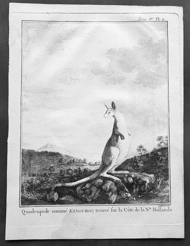
1774 Capt. Cook, S. Parkinson & G. Stubbs - Antique Print Australian Kangaroo in 1770
- Title : Quadrupede nomme Kanguroo trouve fur la Cote de la N.Hollande
[The Kanguroo, an Animal found on the Coast of New Holland] - Ref : 35016
- Size: 10in x 8in (255mm x 205mm)
- Date : 1774
- Condition: (A+) Fine Condition
Description:
This fine original copper-plate engraved antique print of a Kangaroo, first sketched by Sydney Parkinson onboard HMS Endeavour during Cooks first voyage in 1770, whilst laid up at Endeavour River in northern Queensland, was engraved by Robert Benard, after a painting by the famous English Artist George Stubbs in 1772. This original engraving was published in the 1774 French edition of Capt. James Cooks 1st Voyage of Discovery to the South Seas by John Hawkesworth in An Account of the Voyages Undertaken by the Order of His Present Majesty for Making Discoveries in the Southern Hemisphere and Successively Performed by Commodore Byron, Captain Wallis, Captain Carteret, and Captain Cook, in the Dolphin, the Swallow, and the Endeavor, Drawn Up from the Journals Which Were Kept by the Several Commanders, and from the Papers of Joseph Banks. Paris, 1774.
From Sydney Parkinsons Journal........soon after we arrived in the bay, we laid the ship on a steep bank, on the side of a river; set up tents on shore, unloaded her, carried all the cargo and provisions into them, and there lodged and accommodated our sick.
On the 22d, we examined the ship’s bottom, and found a large hole; through the planks into the hold, which had a piece of coral-rock, half a yard square, sticking in it: the same rock, therefore, that endangered us, yielded us the principal means of our redemption; for, had not this fragment intruded into the leak, in all probability the ship would have sunk.
We lost no time, but immediately set about repairing the ship’s bottom, and in a few days made it sound again. In the mean time, the boats were sent out, in search of another passage, which they found, and returned to the ship on the 3d of July.
On the 4th of July, the ship was carried to the other side of the river, and examined thoroughly; but, being found in good condition, she was soon placed in her former station; where she was loaded, and properly fitted to proceed on the voyage.
During the time we staid here, we picked up a great many natural curiosities from the reef we struck upon, consisting of a variety of curious shells, most of which were entirely new to Mr. Banks and Dr. Solander ...
Of quadrupeds, there are goats, wolves, a small red animal about the size of a squirrel; a spotted one of the viverra kind, and an animal of a kind nearly approaching the mus genus, about the size of a grey-hound, that had a head like a fawn’s; lips and ears, which it throws back, like a hare’s; on the upper jaw six large teeth; on the under one two only; with a short and small neck, near to which are the fore-feet, which have five toes each, and five hooked claws; the hinder legs are long, especially from the last joint, which, from the callosity below it, seems as if it lies flat on the ground when the animal descends any declivity; and each foot had four long toes, two of them behind, placed a great way back, the inner one of which has two claws; the two other toes were in the middle, and resembled a hoof, but one of them was much larger than the other. The tail, which is carried like a grey-hound’s, was almost as long as the body, and tapered gradually to the end. The chief bulk of this animal is behind; the belly being largest, and the back rising toward the posteriors. The whole body is covered with short ash-coloured hair; and the flesh of it tasted like a hare’s, but has a more agreeable flavour................
General Definitions:
Paper thickness and quality: - Heavy and stable
Paper color : - off white
Age of map color: -
Colors used: -
General color appearance: -
Paper size: - 10in x 8in (255mm x 205mm)
Plate size: - 9 1/2in x 7 1/4in (240mm x 185mm)
Margins: - Min 1/2in (12mm)
Imperfections:
Margins: - Light soiling in margins
Plate area: - None
Verso: - None
Background:
Sydney Parkinson 1745 – 71 was draughtsman to the botanist Sir Joseph Banks on James Cook’s first voyage to the Pacific in 1768. He died of dysentery in 1771, on the homeward voyage.
Parkinson was the first European artist to create drawings of Indigenous Australian, Maori & South Sea peoples, as well as landscapes, from direct observation. Hundreds of his original drawings survive in the British Museum. He is particularly remembered for his plant illustrations which were later used to create the lavish plates for Joseph Banks’ Florilegium.
When the Endeavour returned to England in 1772, a dispute arose between Joseph Banks and Sydney’s brother, Stanfield Parkinson. As his employer, Banks claimed rights to Sydney’s drawings, papers and collections made on the voyage. Stanfield claimed that Sydney had willed them to his family. Banks lent the Parkinson family Sydney’s journal and drawings with instructions that they were not to be published, however Stanfield disregarded this and arranged for A Journal of a voyage to the South Seas to be printed from Sydney’s account of the voyage.
Banks managed to suppress Stanfield’s publication until the official account of the voyage, edited by John Hawkesworth, appeared. In return for Parkinson’s papers, Banks paid Stanfield Parkinson 500 pounds for balance of wages due to Sydney, but the dispute did not end there. Stanfield further accused Banks of retaining items collected by Sydney which were intended for his relatives. Stanfield Parkinson was declared insane soon after the publication of Sydney Parkinson’s Journal and died in an asylum.
John Hawkesworth An English writer and journalist, Hawkesworth was commissioned by the British Admiralty to edit for publication the narratives of its officers’ circumnavigations. He was given full access to the journals of the commanders and the freedom to adapt and re-tell them in the first person. Cook was already on his way back from his second Pacific voyage, temporarily docked at Cape Town (South Africa), when he first saw the published volumes: he was mortified and furious to find that Hawkesworth claimed in the introduction that Cook had seen and blessed (with slight corrections) the resulting manuscript. (In his defense, Hawkesworth also had been a victim of misunderstanding.) Cook had trouble recognizing himself. Moreover, the work was full of errors and commentary introduced by Hawkesworth and, in Cook’s view, too full of Banks, who had promoted himself and the publication. Still, the work was popular; the first edition sold out in several months.
Robert Bénard 1734 – 1777 was an 18th-century French engraver.
Specialized in the technique of engraving, Robert Ménard is mainly famous for having supplied a significant amount of plates (at least 1,800) to the Encyclopédie by Diderot & d\'Alembert from 1751.
Later, publisher Charles-Joseph Panckoucke reused many of his productions to illustrate the works of his catalog.
George Stubbs ARA 1724 – 1806 was an English painter, best known for his paintings of horses. His most famous work is probably Whistlejacket, a painting of a prancing horse commissioned by the 2nd Marquess of Rockingham, which is now in the National Gallery in London. This and two other paintings carried out for Rockingham break with convention in having plain backgrounds. Throughout the 1760s he produced a wide range of individual and group portraits of horses, sometimes accompanied by hounds. He often painted horses with their grooms, whom he always painted as individuals. Meanwhile, he also continued to accept commissions for portraits of people, including some group portraits. From 1761 to 1776 he exhibited at the Society of Artists of Great Britain, but in 1775 he switched his allegiance to the recently founded but already more prestigious Royal Academy of Arts.
Stubbs also painted more exotic animals including lions, tigers, giraffes, monkeys, and rhinoceroses, which he was able to observe in private menageries. His painting of a kangaroo in 1772 after Cooks 1st Voyage to Australia, was the first glimpse of this animal for many 18th-century Britons
1874 Colonial Govt. Text & Maps on Boundary between South Australia & Victoria
- Title : 1874 Victoria - Papers relating to The Boundary Line Between South Australia and victoria - presented to both houses of parliament by his excellencys Command...John Ferres, Gov. Printer, Melbourne
- Ref #: 91463
- Size: 4to
- Date : 1874
- Condition: (A+) Fine Condition
Description:
This very scarce original Australian Government report prepared for both houses of Parliament over the boundary between the states of South Australia and Victoria was presented in 1874. The bound submission contains 28 pages of parliamentary conversations, reports and tables relating to the conflict over the boundary and two photo lithograph maps one of the Lower part of the Glenelg River showing the old and new proposed boundary lines and the 2nd map shows the original boundary line between NSW and South Australia and the subsequent Victorian boundary line.
This is an amazingly rare document (I have never seen one outside of the state or federal libraries) giving us a snapshot into a controversial period in the history of the two states.
Bound in 4to (14in x 9in) hard boards with ties, clean paper (some joined at top of page) in fine condition.
Background:
The border between the Australian state of South Australia and what is today the State of Victoria was established in 1836 by imperial letters patent "as the 141st degree meridian of longitude east of Greenwich". In 1836 the land we now call Victoria was part of the colony of New South Wales, so the original Victorian border was actually drawn between the colonies of South Australia and New South Wales. Due to human error by numerous explorers and surveyors, it took more than 75 years and a protracted legal dispute before the precise placement of the border was settled, resulting in the forfeiture of more than 1,300 km2 (500 sq mi) of territory from South Australia to Victoria.
Following the establishment of the colony of South Australia in 1835, the region between the coast and the Murray River was rapidly being settled by squatters selecting large runs for sheep grazing. With no clear border legal oversight was impossible. An accurate border needed to be defined. The earliest relevant reference to the eastern boundary of South Australia is contained in a despatch dated 30 September 1844 from Governor Grey of that Colony to Lord Stanley. The Governor reminded the Secretary of State that it would be extremely difficult to determine with accuracy a number of points upon the earth's surface through which the 141st degree of East longitude passes, and pointed out that in addition to difficulty there would be attendant expense both in ascertainment and maintenance.
In 1839 Charles Tyers was transferred from the Royal Navy to the Colonial Service and instructed by Sir George Gipps, the Governor of New South Wales, to ascertain the precise longitude at the mouth of the Glenelg River so that a distance to the 141st meridian (the eastern border of South Australia) could be measured.
Several months later Tyers completed a survey from Melbourne to the Glenelg River and on an expanse of sandy beach he formed a broad arrow with limestone rocks. This became known as Tyers' Mark and was used to determine the starting point for the border survey. Due to primarily inadequate equipment this was later determined to be 2 miles and 4 chains (3.3 km) in error.
For several years following Tyers' survey no action was taken to extend his work but by 1845 the need to have the boundary line defined on the ground had become urgent, particularly to the east of Mount Gambier. South Australian pastoralists had worked their way east from the coast and there were disputes when they met pastoralists from the Wimmera country pushing their way westwards with flocks of sheep.
There was uncertainty as to which Government should grant pastoral licenses to the squatters and which had legal control. In November 1846 the Colonial Secretary's Office directed surveyor Henry Wade to proceed from Sydney to the disputed territory to define a "Boundary for Police Purposes".
By March 1847 Wade had got his party of seven and equipment at the mouth of the Glenelg River. He was joined by assistant surveyor Edward White who had been appointed by the South Australian government to act as an observer on its behalf.
After much deprivation and hardship due to drought and reluctance by his men to continue with poor work conditions, Wade was still 155 miles (250 km) from the Murray River after nine months of swamp, sand dunes and broken equipment. The expedition collapsed at the 36th parallel of latitude. On 16 December 1847 the South Australian Government published a proclamation that the "line as marked on the ground" by Wade should be "deemed and construed" to be the eastern boundary of South Australia. In March, 1849 New South Wales issued a proclamation in similar terms. Wade later died in 1854.
As the survey was only partially completed the two colonies were in agreement that surveyor White should complete Wade's line to the Murray River as soon as possible. This was doubly urgent as the colony of Victoria was to be proclaimed within twelve months further complicating legal and later political matters.
In August 1849 the extension from Wade's line was begun. White and his party of five were similarly troubled by the severe nature of the Big Desert mallee country: where there was little water in 1847 there was none two years later. Within two weeks mutinous men had deserted him and two of his three horses collapsed from being without water for four days. White led the other until it also lay down, he himself was also on the verge of collapse but he managed to bleed the horse and drink half a pint of the blood. Lost, he did not know how far from the Murray River he was but he managed to stagger on for about two miles (3.2 km) to find himself on the riverbank at the border of three states and the survey completed. After drinking and resting he retreated back to the dead horses and collecting his saddle and bridle he returned to the river, managed to cross it and borrow a horse at Chowilla sheep station. He rode 180 miles (290 km) to Adelaide and filed a report on the survey. White died three years later.
Doubts as to the accuracy of the Wade-White line grew with the availability of better astronomical equipment and the advent of the telegraph. As a result of appointments of Government Astronomers in Sydney and Melbourne there were far more precise values for the longitudes of these places and hence the 141st longitude of the legal border.
By agreement an expedition left Adelaide in April 1868 for Chowilla near the Murray River and the border. It was led by George Smalley, N.S.W. Government Astronomer and Charles Todd South Australian Superindentent of Telegraphs. The purpose was to make transit observations of eleven stars whilst similar observations were made in Melbourne and Sydney. Whilst Tyers had used a small three inch (76 mm) theodolite this expedition had a 45-inch (1,100 mm) telescope, the largest available portable device in Australia at the time.
As a result of their observations Smalley and Todd declared the new 141st meridian. This led to the discovery that the proclaimed border on the ground was at least two miles and 19 chains (3.6 km) to the west of the more accurate measurement of the 141st meridian. The "Disputed Territory" as it was termed between the surveyed border and the actual 141st meridian contained over 500 square miles (1295 km²) of land. By 1849, 47% of it had already been sold freehold or leased out by the Victorian Government. If the more accurate border were adopted, Victoria would not have owned the land to be able to sell or lease it. This was the beginning of the battle of the Disputed Territory, a bone of contention which was to last for more than forty years.
The South Australian Government did not let the matter rest. In 1874 it suggested the value of the land was about £800,000. Between 1883 and 1893 South Australia sent more than 70 letters or telegrams to Melbourne seeking Victorian relinquishment or financial redress. There were many futile conferences. The nearest to an agreement between the two states was in 1908. Then it was decided, subject to ratification by Parliament, that £215,000 should be regarded as compensation to South Australia. Parliament did not ratify the proposal, nor did anything come of the 1909 South Australian premier's plan to send surveyors to subdivide some of the land on the east of White's marked border, the last "legally proclaimed" border.
South Australia finally abandoned all hope of settlement, due to Victoria's intransigence, and in 1911 it appealed to the High Court only to have the appeal dismissed. In 1914, it resorted to an appeal to the Judicial Committee of the Privy Council which unanimously ruled in favour of Victoria. (Ref Tooley M&B)
General Description:
Paper thickness and quality: - Heavy and stable
Paper color: - White
Age of map color: -
Colors used: -
General color appearance: -
Map #1 size: - 13 1/2in x 11in (345mm x 280mm)
Map #2 size: - 14in x 13 1/2in (355mm x 345mm)
Margins: - Min 1/2in (12mm)
Imperfections:
Margins: - None
Plate area: - None
Verso: - None
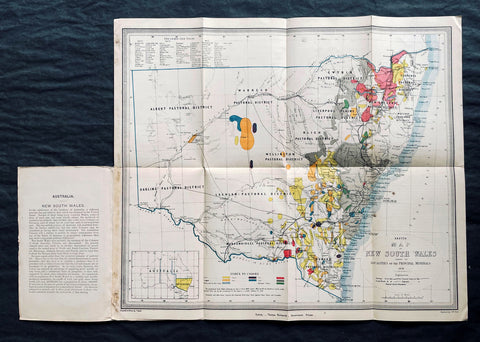
1876 Thomas & Tayler Scarce Antique Goldfields & Minerals Map of New South Wales
- Title : Sketch Map of New South Wales showing the Localities of the Principal Minerals 1876
- Ref #: 27011
-
Condition: (A+) Fine Condition
- Size: 18in x 15 1/2in (455mm x 400mm)
- Date : 1876
Description:
This original, incredibly scarce & important, antique lithograph map of New South Wales, illustrating the location of the Principle Minerals of that state, was drawn by John Tayler, engraved by G W Sharp and published by Thomas Richards in 1876 - dated, Sydney
General Definitions:
Paper thickness and quality: - Heavy and stable
Paper color : - off white
Age of map color: - Original
Colors used: - Yellow, green, blue, pink
General color appearance: - Authentic
Paper size: - 18in x 15 1/2in (455mm x 400mm)
Plate size: - 18in x 15 1/2in (455mm x 400mm)
Margins: - Min 1/2in (12mm)
Imperfections:
Margins: - Folds as issued
Plate area: - Folds as issued
Verso: - Folds as issued
Background:
The map shows New South Wales' new (and current) boundaries, with the state's 'Pastoral Districts' delineated; railways from Ports Hunter and Jackson are shown, along with their proposed extensions inland. Roads and telegraph lines are also indicated. Relief is shown by hachure. An inset map in the lower left shows the state's location on the Australian continent. These features are shared by the authors' other maps of New South Wales, the 1871 Map of New South Wales and the 1878 Sketch map of New South Wales showing the principal agricultural districts. Specific to this map, areas printed in color show the regions understood to be rich in minerals: Kerosene shale, coal, tin, iron, silver, copper, gold and 'diamonds and other gems.' The data on the map reflects the experience of some twenty years of prospecting in New South Wales, but predate the first systematic geological survey of the state, which would not be completed until 1880. The map specifies that the gold fields are 'proclaimed' gold fields, that is to say, permissible for prospectors. No prospector's claim was valid unless it fell within the limits of a 'proclaimed' field, which was officially recognized by the state and administered by a commissioner. The earlier 1873 edition of this map distinguishes between 'proclaimed' and 'unproclaimed' fields; in the present edition, the 'unproclaimed' fields have disappeared entirely. By 1876, control of gold mining in the state had passed from the Department of Lands to a new administration, the Department of Mines; in conjunction with this, mining had become less of a prospector-driven, 'gold rush' affair and more the province of mining companies employing more sophisticated processes, capable of extracting wealth from existing claims in which lower-capitalized operations were ineffective.
John Tayler 1861 - 1875 was an Australian cartographer and draftsman, employed by the NSW Surveyor Generals Office. His 1871 Map of New South Wales appears to have provided the basis for the bulk of the maps of the state produced prior to the Geological survey of 1880.
Richards, Thomas (1831 - 1898)
Thomas Richards, government printer, was born on 21 December 1831 in Pitt Street, Sydney, son of James Richards, builder, and his wife Mary, née OBrien. He was baptized a Catholic. His parents died in his infancy and he was reared by his aunt, the daughter of a sergeant-major in the First Fleet, and educated at Ebenezer on the Hawkesbury River. Having answered an advertisement for an intelligent youth, on 1 January 1845 he was engaged as an apprentice in the Government Printing Office, where he advanced as clerk, proof-reader, compositor, pressman, overseer and, in 1854, superintendent. In June 1859 he became government printer and inspector of stamps at a salary of £500, which had been reduced from his predecessors £850, but was raised to £600 in 1863; he had a staff of seventy. As he lacked London experience his appointment was unpopular. From 1 July 1879 he was also registrar of copyright.
During Richardss innovative administration, with increasing volume of work, the office expanded its functions and techniques. In 1863 he introduced photo-lithography and, after he had observed plant in Victoria in 1864, he added stereo-typing and electro-typing. In 1868 following the establishment of extra branches a new fast process of photo-lithography was invented by John Sharkey whose experiments were encouraged and assisted by Richards. The Sydney Morning Herald praised the gems of photo-lithographic art the Printing Office displayed at the 1870 Intercolonial Exhibition at Sydney. Later Richards initiated helio-type or photo-mechanical printing, introduced a perforating machine and invented a method of drying stamps with heat from gas. He devised an arithmotype bars system for numbering debentures which was adopted in all the colonies and England; he alleged the Bank of England took the patent without acknowledgment.
Frequently working long hours, Richards was criticized by some politicians for his administration and his publication of documents of allegedly limited public interest. He defended himself adequately before the 1870 select committee on the Government Printing Office, resisting suggestions of reductions in salaries and praising his men for the finest examples of the modern technique of photo-lithography seen in the colonies; and he admitted ambitions to produce an Australian geography and natural history, a year-book and dictionary of names for New South Wales. Looking back in 1891 he wrote, I had opposed to me a truculent minister, a truculent under-secretary and a truculent newspaper proprietor … I beat them but came out of the fray wounded in mind body and estate. He also had trouble with trade unions in difficult industrial times for heads of government departments and in 1875 antagonized the Trades and Labor Council by threatening to close the Office against all union men.
In 1877 Richards represented the government on an English committee to celebrate the quatercentenary of Caxtons introduction of printing. With twelve months leave he also studied advanced methods and bought new machinery. At the 1878 Paris Universal Exhibition he won a silver and two bronze medals and at the 1880 Melbourne International Exhibition he won five high diplomas for printing, bookbinding and photography. The 1883 Amsterdam Exhibition awarded him a gold and a silver medal, and the Printing Office was commended at other important exhibitions from 1862 to 1886. In 1882 Richards compiled, edited and printed the highly regarded New South Wales in 1881, which was translated into French; next year the office produced An Epitome of the Official History of New South Wales.
On 23 April 1861 Richards had joined the Volunteer Rifles as a second lieutenant. A good shot and member of the New South Wales Rifle Association, in 1885 he became lieutenant-colonel of the first regiment, Volunteer Infantry; he resigned next year. In November 1886, because of rapidly failing eyesight, Richards retired as government printer on a pension of £480; he left a staff of 400 and an office with sixty-one new departments. On 31 August 1898 he died at Manly and was buried in the Anglican cemetery there. On 29 January 1865, with Anglican rites, he had married Zara Bell, by whom he had three daughters and two sons who survived him.
Please note all items auctioned are genuine, we do not sell reproductions. A Certificate of Authenticity (COA) can be issued on request.
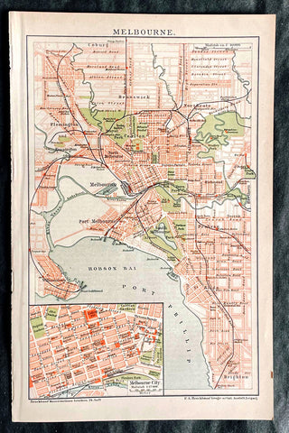
1896 F.A. Brockhaus Antique Map, Street Plan of Melbourne, Victoria, Australia
- Title : Melbourne
- Ref #: 27012
-
Condition: (A+) Fine Condition
- Size: 10in x 6 1/2in (255mm x 165mm)
- Date : 1896
Description:
This original antique lithograph street map of Melbourne Australia was engraved and published F.A. Brockhaus for the Brockhaus Konversations Lexikon, Germany, 1896
General Definitions:
Paper thickness and quality: - Heavy and stable
Paper color : - off white
Age of map color: - Original
Colors used: - Yellow, green, blue, pink
General color appearance: - Authentic
Paper size: - 10in x 6 1/2in (255mm x 165mm)
Plate size: - 10in x 6 1/2in (255mm x 165mm)
Margins: - Min 1/2in (12mm)
Imperfections:
Margins: - None
Plate area: - None
Verso: - None
Brockhaus, Friedrich Arnold (1772 - 1823)
Friedrich Arnold Brockhaus was a German encyclopedia publisher and editor, famed for publishing the Conversations-Lexikon, which is now published as the Brockhaus encyclopedia.
Brockhaus was educated at the gymnasium of his native Dortmund, and from 1788 to 1793 served an apprenticeship in a mercantile house at Düsseldorf. He then devoted two years at the University of Leipzig to the study of modern languages and literature, after which he set up in Dortmund an emporium for English goods. In 1801, he transferred this business to Arnheim, and in the following year to Amsterdam.
In 1805, having given up his first line of trade, Brockhaus began business as a publisher. Two journals projected by him were not allowed by the government to survive for any length of time, and in 1810 the complications in the affairs of Holland induced him to return homewards. In 1811 he settled at Altenburg. About three years previously he had purchased the copyright of the bankrupt Conversations-Lexikon, an encyclopedia started in 1796, and in 1810-1811 he completed the first edition of this celebrated work. It was widely imitated as a model for encyclopedias, and is still published today, known as the Brockhaus Encyclopedia.
A second edition under Brockhauss editorship was begun in 1812, and was received with universal favour. His business extended rapidly, and in 1818 Brockhaus moved to Leipzig, where he established a large printing-house. Among the more extensive of his many literary undertakings were the critical periodicals — Hermes, the Literarisches Konversationsblatt (afterwards the Blätter für literarische Unterhaltung) and the Zeilgenossen, and some large historical and bibliographical works, such as Friedrich Ludwig Georg von Raumers Geschichte der Hohenstaufen, and Friedrich Adolf Eberts Allgemeines bibliographisches Lexikon.
Brockhaus died in Leipzig. The business was carried on by his sons, Friedrich Brockhaus (1800–1865), who retired in 1850, and Heinrich Brockhaus (1804–1874), under whom it was considerably extended. Heinrich especially rendered great services to literature and science, which the University of Jena recognized by making him, in 1858, honorary Doctor of Philosophy. In the years 1842–1848, Heinrich Brockhaus was member of the Saxon second chamber, as representative for Leipzig, was made honorary citizen of that city in 1872, and died there on 15 November 1874.
His firm continues under the name F.A. Brockhaus AG in his honor. He is also the namesake of 27765 Brockhaus, a main-belt asteroid discovered in 1991.
Please note all items auctioned are genuine, we do not sell reproductions. A Certificate of Authenticity (COA) can be issued on request.
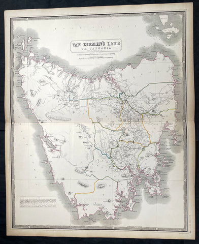
1856 A K Johnston Large Antique Map of Van Diemens Land or Tasmania, Australia
- Title : Van Diemens Land or Tasmania by A K Johnston
- Date : 1856
- Condition: (A+) Fine Condition
- Ref: 27002
- Size: 25in x 21 1/2in (635mm x 545mm)
This original large hand coloured steel plate engraved antique map was published by A K Johnston in the 1856 edition of his National atlas of historical, commercial, and political geography.
General Definitions:
Paper thickness and quality: - Heavy and stable
Paper color : - off white
Age of map color: - Original
Colors used: - Yellow, green, blue, pink
General color appearance: - Authentic
Paper size: - 25in x 21 1/2in (635mm x 545mm)
Plate size: - 25in x 21 1/2in (635mm x 545mm)
Margins: - Min 1/2in (12mm)
Imperfections:
Margins: - Light age toning
Plate area: - Light age toning
Verso: - Light age toning
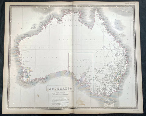
1856 A K Johnston Large Antique Map of Australia, early Separation of Victoria
- Title : Australia by A K Johnston
- Date : 1856
- Condition: (A+) Fine Condition
- Ref: 27000
- Size: 25in x 21 1/2in (635mm x 545mm)
Description:
This original large hand coloured steel plate engraved antique map of Australia - with coloured outlines to the counties in NSW & WA - was published by A K Johnston in the 1856 edition of his National atlas of historical, commercial, and political geography.
A important and interesting map illustrating the boundary of South Australia, as well as the county boundaries in both Western Australia and New South Wales. One of the first maps to illustrate the separation of the state of Victoria from New South Wales in 1851.
General Definitions:
Paper thickness and quality: - Heavy and stable
Paper color : - off white
Age of map color: - Original
Colors used: - Yellow, green, blue, pink
General color appearance: - Authentic
Paper size: - 25in x 21 1/2in (635mm x 545mm)
Plate size: - 25in x 21 1/2in (635mm x 545mm)
Margins: - Min 1/2in (12mm)
Imperfections:
Margins: - Light age toning
Plate area: - Light age toning
Verso: - Light age toning
Background:
Australia is a sovereign country comprising the mainland of the Australian continent, the island of Tasmania and numerous smaller islands. It is the largest country in Oceania and the world\\\'s sixth-largest country by total area. The neighbouring countries are Papua New Guinea, Indonesia and East Timor to the north; the Solomon Islands and Vanuatu to the north-east; and New Zealand to the south-east. The population of 25 million is highly urbanised and heavily concentrated on the eastern seaboard. Australias capital is Canberra, and its largest city is Sydney. The country\\\'s other major metropolitan areas are Melbourne, Brisbane, Perth and Adelaide.
Australia was inhabited by indigenous Australians for about 60,000 years before the first British settlement in the late 18th century. It is documented that Aborigines spoke languages that can be classified into about 250 groups. After the European discovery of the continent by Dutch explorers in 1606, who named it New Holland, Australia\\\'s eastern half was claimed by Great Britain in 1770 and initially settled through penal transportation to the colony of New South Wales from 26 January 1788, a date which became Australia\\\'s national day. The population grew steadily in subsequent decades, and by the 1850s most of the continent had been explored and an additional five self-governing crown colonies established. On 1 January 1901, the six colonies federated, forming the Commonwealth of Australia. Australia has since maintained a stable liberal democratic political system that functions as a federal parliamentary constitutional monarchy comprising six states and ten territories.
Being the oldest, flattest and driest inhabited continent, with the least fertile soils, Australia has a landmass of 7,617,930 square kilometres. A megadiverse country, its size gives it a wide variety of landscapes, with deserts in the centre, tropical rainforests in the north-east and mountain ranges in the south-east. A gold rush began in Australia in the early 1850s, which boosted the population of the country. Nevertheless, its population density, 2.8 inhabitants per square kilometre, remains among the lowest in the world. Australia generates its income from various sources including mining-related exports, telecommunications, banking and manufacturing. Indigenous Australian rock art is the oldest and richest in the world, dating as far back as 60,000 years and spread across hundreds of thousands of sites.
The first recorded European sighting of the Australian mainland, and the first recorded European landfall on the Australian continent (in 1606), are attributed to the Dutch. The first ship and crew to chart the Australian coast and meet with Aboriginal people was the Duyfken captained by Dutch navigator, Willem Janszoon. He sighted the coast of Cape York Peninsula in early 1606, and made landfall on 26 February at the Pennefather River near the modern town of Weipa on Cape York. The Dutch charted the whole of the western and northern coastlines and named the island continent New Holland during the 17th century, but made no attempt at settlement. William Dampier, an English explorer and privateer, landed on the north-west coast of New Holland in 1688 and again in 1699 on a return trip. In 1770, James Cook sailed along and mapped the east coast, which he named New South Wales and claimed for Great Britain.
With the loss of its American colonies in 1783, the British Government sent a fleet of ships, the First Fleet, under the command of Captain Arthur Phillip, to establish a new penal colony in New South Wales. A camp was set up and the flag raised at Sydney Cove, Port Jackson, on 26 January 1788, a date which became Australia\\\'s national day, Australia Day. A British settlement was established in Van Diemens Land, now known as Tasmania, in 1803, and it became a separate colony in 1825. The United Kingdom formally claimed the western part of Western Australia (the Swan River Colony) in 1828. Separate colonies were carved from parts of New South Wales: South Australia in 1836, Victoria in 1851, and Queensland in 1859. The Northern Territory was founded in 1911 when it was excised from South Australia. South Australia was founded as a free province—it was never a penal colony. Victoria and Western Australia were also founded free, but later accepted transported convicts. A campaign by the settlers of New South Wales led to the end of convict transportation to that colony; the last convict ship arrived in 1848.
1882 Edward Stanford Large Folding Antique Map Eastern Australia, QLD, NSW, Vic
- Title : Queensland & New South Wales....London Published by Edward Stanford ...March 20th 1882
- Ref : 17064
- Size: 26 1/2in x 22in (680mm x 570mm)
- Date : 1882.
- Condition: (A+) Fine Condition
Description:
This large original hand coloured folding canvas backed antique map of Vicoria, New South Wales & Queensland in Eastern Australia, illustrating Tracks of Travellers, Roads, Railways & Telegraph was published by Edward Stanford, London in 1882, dated at the foot of the map. (Ref: Tooley; M&B)
General Definitions:
Paper thickness and quality: - Heavy and stable
Paper color : - off white
Age of map color: - Original
Colors used: - Blue, yellow, red, green
General color appearance: - Authentic
Paper size: - 26 1/2in x 22in (680mm x 570mm)
Plate size: - 26 1/2in x 22in (680mm x 570mm)
Margins: - Min 1/2in (12mm)
Imperfections:
Margins: - None
Plate area: - None
Verso: - None
Stanford, Edward 1827-1904
Stanford was a prominent British mapmaker and publisher. A native of Holborn in the heart of London, Edward was apprenticed to a printer and stationer at the age of 14. After his first master died, he worked with several others, including Trelawny W. Saunders of Charing Cross. Saunders oversaw young Edward’s early career, ensuring that he became a Fellow of the Royal Geographical Society. Associations with the Society eventually brought Sanders much business and gave him a reputation as a publisher of explorers. As testament to this reputation, the Stanford Range in British Columbia was named for him by John Palliser.
Stanford briefly partnered with Saunders in 1852 before striking out on his own in 1853. He was an agent for the Ordnance Survey, the Admiralty, the Geological Survey, the Trigonometrical Survey of India, and the India Office. He also controlled the maps of the Society for the Diffusion of Useful Knowledge, another lucrative source of income. In 1857, Stanford founded his namesake Geographical Establishment, with Saunders and A. K. Johnston as engravers. Thereafter, Stanford was known for his library maps, particularly those of Africa and Asia.
Although he had authored many maps, the Harrow Atlas of Modern Geography and a similar volume on classical geography, Stanford is better remembered today as the leader of a successful map business. Ever in search of more inventory, he acquired the plates and stock of John Arrowsmith, heir of the Arrowmsith family firm, in 1874. By 1881 he employed 87 people at his premises at 6 Charing Cross Road, Saunders’ old address. As he aged, he phased in his son Edward Jr. to run the business. He died in 1904. The business survived him, and the Stanford’s shop is still a prominent London landmark today.
Stanford premises were located in the Strand, London from 1853 to 1884 and then Cockspur St from 1885 to 1901 locating to its present location in Covent Garden.
1841 Macarthur Antique Octavo Book on Colonial Policy in Australia, Map of NSW
- Title : Colonial Policy of 1840 and 1841, as illustrated by the Governor's Despatches, and Proceedings of the Legislative Council of New South Wales. By Major Macarthur.
- Ref #: 17045
- Size: Octavo
- Date : 1841
- Condition: (A+) Fine Condition
Description:
Fine original antique Octavo book with 79 pages and a single lithographed hand coloured map of eastern Australia & Van Diemens Land; uncut copy in half calf with gilt lettering by Edward Macarthur, advocating for immigration and trade for the colony of Australia, published by John Murray, London in 1841, dated.
This is the first of two books by Sir Edward Macarthurs advocating immigration to the colony of Australia. The eldest son of John and Elizabeth, Edward Macarthur was born at Bath in 1789, and accompanied his parents to New South Wales in 1790. As one of the first free settlers in the colony, he was a strong advocate of immigration, and served as Thomas Macqueens agent in arranging the first shipment of free immigrants in 1824, which gave great stimulus to agriculture.
The map illustrates a division of New South Wales and the subsequent creation of a smaller colony. Titled Eastern Australia or Territory of New South Wales, the map is captioned 'territory to which the Colony might be reduced by Bill of the last session' with reference debate in the House of Commons knocked down by Sir Robert Peel.
General Definitions:
Paper thickness and quality: - Heavy and stable
Paper color : - off white
Age of map color: - Original
Colors used: - Yellow
General color appearance: - Authentic
Paper size: - Octavo
Plate size: - Octavo
Margins: - Octavo
Imperfections:
Margins: - None
Plate area: - None
Verso: - None
Background:
Sir Edward Macarthur (1789-1872), soldier, was born on 16 March 1789 at Bath, England, the eldest son of Captain John Macarthur and his wife Elizabeth. He went to Sydney with his parents in 1790 and spent his boyhood there and at Elizabeth Farm, Parramatta. Sent to England in 1799 to be educated he returned to Sydney in 1806. With his father he took part in the deposition of Governor William Bligh in 1808. He soon left for London taking his father's version of the rebellion and the first bale of merino wool to be exported from the colony. He obtained a commission in the 60th Regiment and served at Corunna and in Sicily. As a lieutenant in the 39th Regiment he took part in Wellington's campaigns of 1812-14 and was present at Vittoria, the Pyrénées and the battles in southern France. After brief service in Canada he joined the army of occupation in France.
In 1824 Macarthur went to New South Wales as the agent of T. P. Macqueen. He was impressed by the dispersion of the garrison from Moreton Bay to Hobart Town in the face of runaway convicts and 'hostile tribes'. In London he placed detailed proposals for a colonial militia before Under-Secretary Horton but the plan was rejected by Governor (Sir) Ralph Darling in 1827. Macarthur competently represented Australian interests in London. He presented a petition from New South Wales in 1840. He advocated emigration in two small books, Colonial Policy of 1840 and 1841, as Illustrated by the Governor's Despatches, and the Proceedings of the Legislative Council of New South Wales (London, 1841) and Brief Remarks on Colonization (London, 1846). He personally arranged the migration of German vinedressers to the Macarthur properties at Camden and also sought to develop coastal steamship services. After serving as secretary in the Lord Chamberlain's Office in 1843-46 he was on the military staff in Ireland. In 1851 he was posted to Sydney as deputy adjutant general. Promoted colonel in 1854, he moved with the headquarters to Melbourne. He accompanied the commander-in-chief, Major-General Sir Robert Nickle, to Eureka on 5 December. They talked freely with the miners and as a result of their investigations Nickle advised that martial law be withdrawn.
After Nickle died in May 1855 and Governor Hotham in December, Macarthur took over command of the forces and became administrator. He inherited a confused political situation and was coolly received by the press. However, his impartiality and his willingness to leave things to his ministers helped him, and when he handed over to Sir Henry Barkly on 23 December 1856 he had won the esteem of parliament and the people of Melbourne. Emily, wife of Hugh Childers, described him as 'if not a brilliant statesman, an industrious, kind-hearted, Christian gentleman'. In 1858 Macarthur chaired a royal commission on the defences of the colony. In 1860 he returned to England and was appointed K.C.B. in 1862. In that year he married Sarah (d.1889), daughter of Lieutenant-Colonel W. S. Neill. Promoted lieutenant-general in 1866, he died childless in London on 4 January 1872 and was buried in the Brompton cemetery. He was survived by his wife. His goods were valued for probate at £4000.
Macarthur, Edward (1789 - 1872)
Macarthur was a lieutenant-general in the British Army, Commander-in-chief of British forces in Australia from 1855, and an administrator of the Colony of Victoria for 12 months, following the death of the Governor, Sir Charles Hotham.
Macarthur was the eldest son of John Macarthur, and his wife Elizabeth (née Veal). He was born at Bath, Somerset, England, and arrived at Sydney with his parents in the ships Neptune and Scarborough in 1790, part of the Second Fleet. Edward Macarthur is believed to be the only passenger on those ships of whom a photograph exists, although taken later in life. In 1799, the young Edward was sent to England to be educated.
Macarthur returned to Australia in 1806 and took part with his father in the deposing of Governor William Bligh. Bligh, in his dispatch to Viscount Castlereagh of 30 April 1808, requested that two of the rebels Charles Grimes and Edward Macarthur who have gone home in the Dart may be secured, in order to be tried in due time. On Macarthurs arrival in England, he entered the army as an ensign in the 60th regiment, serving at Corunna and in Sicily. In 1809, he was promoted to the rank of lieutenant. As part of the 39th Regiment he took part in the Duke of Wellingtons campaigns in the Peninsular War and in France. In 1820 or 1829 he became a captain. In 1824 he paid a visit of 10 months to Australia as an agent of Thomas Potter Macqueen. After Macarthurs return to England, he was for some years secretary to the Lord Chamberlain. In 1826 he was promoted to the rank of major and in 1837 he was on the staff in Ireland.
Macarthur retained his interest in Australia. On 3 July 1839, he addressed a long communication to the Right Hon. Henry Labouchère, suggesting that regular lines of steamers should be established in Australia to trade between the various ports. That was referred to the governor, Sir George Gipps who, in May 1840, replied that government aid was unnecessary, because a large company had been formed to establish a line of steamers, of which James Macarthur (Edwards brother) was chairman. Edward Macarthur also promoted emigration in two small books: Colonial Policy of 1840 and 1841, as Illustrated by the Governors Despatches, and the Proceedings of the Legislative Council of New South Wales (London, 1841) and Brief Remarks on Colonization (London, 1846).
In August 1840, Macarthur protested against the regulations that people wanting to take up land in the Port Phillip district should have to proceed to Melbourne where all charts of land were kept for public inspection. He was made a Lieutenant-Colonel in 1841, and afterwards went to New South Wales as deputy adjutant-general. He was promoted to colonel in 1854.
On 5 December 1854, Macarthur travelled with the commander-in-chief of British forces in Australia, Major-General Sir Robert Nickle, to the site of the Eureka Rebellion. There they talked with the miners openly and, as a result of their investigations, Nickle advised the withdrawal of martial law. Macarthur was appointed commander-in-chief of British forces in Australia in 1855, to replace Nickle. On 1 January 1856, after the death of Governor of Victoria, Sir Charles Hotham, Macarthur was administrator of the colony of Victoria for 12 months.
Macarthur returned to London in 1860. In 1862, he was created a Knight Commander of the KCB and, in the same year, was given the colonelcy of the 100th (Prince of Waless Royal Canadian) Regiment of Foot, a position he held until his death.
He died in London on 4 January 1872 and was buried in Brompton Cemetery. In 1862, at the age of 73, he had married Sarah (daughter of Lieutenant-Colonel W. S. Neill), who survived him. There were no children.
Please note all items auctioned are genuine, we do not sell reproductions. A Certificate of Authenticity (COA) can be issued on request.
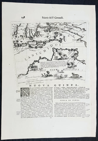
1692 Vincenzo Coronelli Antique Globe Gore Rare Map of Australia, Indonesia
- Title : Nuova Guinea
- Size: 19 1/2in x 14in (495mm x 360mm)
- Condition: (A+) Fine Condition
- Date : 1692
- Ref #: 30783
Description:
This finely engraved original antique map, a scarce Globe Gore map section - from Vincenzo Coronellis original 42in Globe of Australia, New Guinea and parts of the Islands of Indonesia - one of the earliest detailed maps of Australia - was published by Vincenzo Maria Coronelli in the 1696 Venice edition of Isolario dell Atlante Veneto.
To my mind Coronellis maps are some of the most beautifully engraved maps of the 17th century and the epitome of these are his Globe Gores.
In 1696 Coronelli published all his globe gores - from the 2in to the 42 in Globes - in an atlas, Libero dei Globi, part of the great series of atlases, Isolario dell Atlante Veneto that was published by Coronelli to ensure his work was available to a wider audience, as very few could afford travel to Venice, Rome or Paris to view his completed globes.
General Definitions:
Paper thickness and quality: - Heavy and stable
Paper color : - off white
Age of map color: -
Colors used: -
General color appearance: -
Paper size: - 19 1/2in x 14in (495mm x 360mm)
Plate size: - 11 1/2in x 9 1/2in (280mm x 235mm)
Margins: - Min 1in (25mm)
Imperfections:
Margins: - None
Plate area: - None
Verso: - None
Background:
The original globe gores for the 42in Terrestrial & Celestial Globe were printed on 12 full length sheets - with two polar calottes - in 1688.
To help fit into Coronellis future publications of Atlante Veneto, Libro dei Globi and Isolario dell Atlante Veneto the gore sheets were re-issued as the same size but cut into smaller sections. This effectively allowed the gores to be published in their original size but instead of one sheet per gore there were 2, 4 or 6 sheets making up the one gore.
The first edition of Coronellis 3 ½-foot celestial globe was engraved by Nolin in Paris after drawings provided by the Italian geographer and was printed in 1688. At the same time, its terrestrial counterpart was engraved and printed in Venice under Coronellis direction. These globes were produced in part as replicas of the gigantic and unique 15 foot-diameter pair of globes that Coronelli constructed and presented to Louis XIV, the King of France, in 1683, and which secured his fame as Europes premier globe maker. In 1693, soon after Coronelli engraved and printed the first Venetian edition of the 3 ½-foot celestial globe, Nolin engraved at Paris an entirely new edition on new plates. This globe was based on Coronellis work, but with the main legends in Latin, not Italian, as befitted a French market. The 3 ½ foot celestial globe was one of the crowning glories of Coronellis output and was also the grandest celestial globe of the 17th century.
(Ref: Shirley; Armao, Ermanno. Vincenzo Coronelli Cenni sulluomo e la sua Vita Catalogo... Bibliopolis, Florence pp.130-134)