Maps (911)
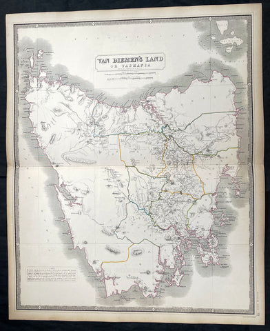
1856 A K Johnston Large Antique Map of Van Diemens Land or Tasmania, Australia
- Title : Van Diemens Land or Tasmania by A K Johnston
- Date : 1856
- Condition: (A+) Fine Condition
- Ref: 27002
- Size: 25in x 21 1/2in (635mm x 545mm)
This original large hand coloured steel plate engraved antique map was published by A K Johnston in the 1856 edition of his National atlas of historical, commercial, and political geography.
General Definitions:
Paper thickness and quality: - Heavy and stable
Paper color : - off white
Age of map color: - Original
Colors used: - Yellow, green, blue, pink
General color appearance: - Authentic
Paper size: - 25in x 21 1/2in (635mm x 545mm)
Plate size: - 25in x 21 1/2in (635mm x 545mm)
Margins: - Min 1/2in (12mm)
Imperfections:
Margins: - Light age toning
Plate area: - Light age toning
Verso: - Light age toning
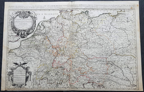
1692 Jaillot Large Antique Map of Allemagne or German Empire, Central Europe
- Title : L Empire D Allemagne distingue suivant l´etenedu de tous les estates principautes et souverainites...A Paris Chez...H Jaillot....1692
- Size: 37in x 24in (940mm x 615mm)
- Condition: (A+) Fine Condition
- Date : 1692
- Ref #: 16382
Description:
This very large, hand coloured original antique map of the German Empire and central Europe in the late 17th century by Alexis Hubert Jaillot - after Nicolas Sanson - was engraved in 1692 - the date is engraved in the dedication cartouche.
General Definitions:
Paper thickness and quality: - Heavy and stable
Paper color : - off white
Age of map color: - Original
Colors used: - Yellow, green, blue, pink
General color appearance: - Authentic
Paper size: - 37in x 24in (940mm x 615mm)
Plate size: - 36in x 23in (930mm x 605mm)
Margins: - Min 1/2in (12mm)
Imperfections:
Margins: - None
Plate area: - None
Verso: - None
Background:
The name Allemagne for Germany and the other similar-sounding names above are derived from the southern Germanic Alemanni, a Suebic tribe or confederation in todays Alsace, parts of Baden-Württemberg and Switzerland.
In 800, the Frankish king Charlemagne was crowned emperor and founded the Carolingian Empire, which was later divided in 843 among his heirs. Following the break up of the Frankish Realm, for 900 years, the history of Germany was intertwined with the history of the Holy Roman Empire, which subsequently emerged from the eastern portion of Charlemagnes original empire. The territory initially known as East Francia stretched from the Rhine in the west to the Elbe River in the east and from the North Sea to the Alps. The Ottonian rulers (919–1024) consolidated several major duchies and the German king Otto I was crowned Holy Roman Emperor of these regions in 962. In 996 Gregory V became the first German Pope, appointed by his cousin Otto III, whom he shortly after crowned Holy Roman Emperor. The Holy Roman Empire absorbed northern Italy and Burgundy under the reign of the Salian emperors (1024–1125), although the emperors lost power through the Investiture controversy.
In the 12th century, under the Hohenstaufen emperors (1138–1254), German princes increased their influence further south and east into territories inhabited by Slavs; they encouraged German settlement in these areas, called the eastern settlement movement (Ostsiedlung). Members of the Hanseatic League, which included mostly north German cities and towns, prospered in the expansion of trade. In the south, the Greater Ravensburg Trade Corporation (Große Ravensburger Handelsgesellschaft) served a similar function. The edict of the Golden Bull issued in 1356 by Emperor Charles IV provided the basic constitutional structure of the Empire and codified the election of the emperor by seven prince-electors who ruled some of the most powerful principalities and archbishoprics.
Population declined in the first half of the 14th century, starting with the Great Famine in 1315, followed by the Black Death of 1348–50. Despite the decline, however, German artists, engineers, and scientists developed a wide array of techniques similar to those used by the Italian artists and designers of the time who flourished in such merchant city-states as Venice, Florence and Genoa. Artistic and cultural centres throughout the German states produced such artists as the Augsburg painters Hans Holbein and his son, and Albrecht Dürer. Johannes Gutenberg introduced moveable-type printing to Europe, a development that laid the basis for the spread of learning to the masses.
In 1517, the Wittenberg priest Martin Luther nailed the Ninety-Five Theses to the church door, challenging the practice of selling of indulgences. He was subsequently excommunicated in the papal bull Exsurge Domine in 1520, and his followers were condemned in the 1521 Diet of Worms, which divided Western Christianity. In 1555, the Peace of Augsburg tolerated the Evangelical faith (now called Lutheranism) as an acceptable alternative to Catholicism, but also decreed that the faith of the prince was to be the faith of his subjects, a principle called cuius regio, eius religio. The agreement at Augsburg failed to address other religious creed: for example, the Reformed faith was still considered a heresy and the principle did not address the possible conversion of an ecclesiastic ruler, such as happened in Electorate of Cologne in 1583. However, in practice Calvinists were given protection under the Augsburg Confession Variata modified upon request by Philip Melanchthon.
From the Cologne War until the end of the Thirty Years Wars (1618–1648), religious conflict devastated German lands. The latter reduced the overall population of the German states by about 30 per cent, and in some places, up to 80 per cent. The Peace of Westphalia ended religious warfare among the Imperial Estates of the Holy Roman Empire. Their mostly German-speaking rulers were able to choose either Roman Catholicism, Lutheranism, or the Reformed faith as their official religion after 1648.
In the 18th century, the Holy Roman Empire consisted of approximately 1,800 territories. The elaborate legal system initiated by a series of Imperial Reforms (approximately 1450–1555) created the Imperial Estates and provided for considerable local autonomy among ecclesiastical, secular, and hereditary states, reflected in the Imperial Diet. The House of Habsburg held the imperial crown from 1438 until the death of Charles VI in 1740. Having no male heirs, he had convinced the Electors to retain Habsburg hegemony in the office of the emperor by agreeing to the Pragmatic Sanction of 1713. This was finally settled through the War of Austrian Succession; in the Treaty of Aix-la-Chapelle, Charles VIs daughter Maria Theresa ruled the Empire as Empress Consort when her husband, Francis I, became Holy Roman Emperor. From 1740, the dualism between the Austrian Habsburg Monarchy and the Kingdom of Prussia dominated the German history.
In 1772, then again in 1793 and 1795, the two dominant German states of Prussia and Austria, along with the Russian Empire, agreed to the Partitions of Poland; dividing among themselves the lands of the Polish–Lithuanian Commonwealth. As a result of the partitions, millions of Polish speaking inhabitants fell under the rule of the two German monarchies. However, the annexed territories though incorporated into the Kingdom of Prussia and the Habsburg Realm, were not legally considered as a part of the Holy Roman Empire. During the period of the French Revolutionary Wars, along with the arrival of the Napoleonic era and the subsequent final meeting of the Imperial Diet, most of the secular Free Imperial Cities were annexed by dynastic territories; the ecclesiastical territories were secularised and annexed. In 1806 the Imperium was dissolved; many German states, particularly the Rhineland states, fell under the influence of France. Until 1815, France, Russia, Prussia and the Habsburgs (Austria) competed for hegemony in the German states during the Napoleonic Wars.
Following the fall of Napoleon, the Congress of Vienna (convened in 1814) founded the German Confederation (Deutscher Bund), a loose league of 39 sovereign states. The appointment of the Emperor of Austria as the permanent president of the Confederation reflected the Congresss failure to accept Prussias rising influence among the German states, and acerbated the long-standing competition between the Hohenzollern and Habsburg interests. Disagreement within restoration politics partly led to the rise of liberal movements, followed by new measures of repression by Austrian statesman Metternich. The Zollverein, a tariff union, furthered economic unity in the German states.
National and liberal ideals of the French Revolution gained increasing support among many, especially young, Germans. The Hambach Festival in May 1832 was a main event in support of German unity, freedom and democracy. In the light of a series of revolutionary movements in Europe, which established a republic in France, intellectuals and commoners started the Revolutions of 1848 in the German states. King Frederick William IV of Prussia was offered the title of Emperor, but with a loss of power; he rejected the crown and the proposed constitution, leading to a temporary setback for the movement.
Foundation of the German Empire in Versailles, 1871. Bismarck is at the centre in a white uniform.
King William I appointed Otto von Bismarck as the new Minister President of Prussia in 1862. Bismarck successfully concluded war on Denmark in 1864, which promoted German over Danish interests in the Jutland peninsula. The subsequent (and decisive) Prussian victory in the Austro-Prussian War of 1866 enabled him to create the North German Confederation (Norddeutscher Bund) which excluded Austria from the federations affairs. After the French defeat in the Franco-Prussian War, the German princes proclaimed the founding of the German Empire in 1871 at Versailles, uniting all the scattered parts of Germany except Austria and the German-speaking parts of Switzerland. Prussia was the dominant constituent state of the new empire; the Hohenzollern King of Prussia ruled as its concurrent Emperor, and Berlin became its capital.
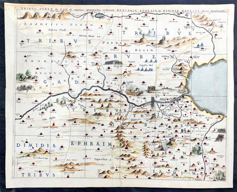
1662 Hornius & Jansson Antique Holy Land Map Tribes Ruben, Gad, Benjamin, Ephraim & Manasseh
- Title : Tribus Ruben, et Gad parties orientales tribumum Beniamin, Ephraim, et Dimidiae, Manasse, intra Jordanem
- Ref #: 17016
- Size: 23in x 18 1/2in (580mm x 470mm)
- Date : 1662
- Condition: (A+) Fine Condition
Description:
This large, important & scarce hand coloured original copper-plate engraved antique map, one of six, of the Tribes of Ruben, Gad, Benjamin, Ephraim & Manasseh located to the north and east of the Dead Sea was published by Jan Jansson & Georguis Hornius (1620-1670) in the 1662 French Edition of Atlas Major, based on the 1590 map of Christian van Adricham, Situs Terrae Promissionis.
This map is #1 of 6 published by Jansson that combined measures 66in long by 37in wide (1.68m x 940mm) Please see the B&W image to see combined maps.
Tribus Ruben, et Gad et partes orientales tribuum Beniamin, Ephraim, et dimidiae Manasse intra Iordenem. This is usually thought to the be the first panel in the series. It includes several vignettes, such as Jesus and Satan arguing on a mountaintop, Moses looking across the Jordan, the entry point of the Hebrews into the land of Milk and Honey, and a stairway ascending to heaven. This panel shows the lands controlled by Ruben and Gad, as well as the eastern lands of Benjamin, Ephraim, and part of Manasseh beyond the Jordan River. It also shows the western part of the Dead Sea.
General Definitions:
Paper thickness and quality: - Heavy and stable
Paper color : - off white
Age of map color: - Original
Colors used: - Yellow, green, blue, pink
General color appearance: - Authentic
Paper size: - 23in x 18 1/2in (580mm x 470mm)
Plate size: - 22in x 17 1/2in (560mm x 445mm)
Margins: - Min 1in (25mm)
Imperfections:
Margins: - Light age toning
Plate area: - None
Verso: - None
Background:
Jan Jansson based his map on Christian van Adrichams Situs Terrae Promissionis of ca. 1590. This version is both expanded and carries additional vignettes and details. Georgius Hornius wrote the text that accompanied the map in volume six of Janssons Novus Atlas, Accuratissimia Orbis Antiqui Delineatio.
The map shows the region divided into domains of the Twelve Tribes of Israel on both sides of the Jordan River, with the shoreline running from Sidon to Alexandria. The Cison Torrens (Kishon River) is shown as connecting the Sea of Galilee with the Mediterranean Sea, and there are many rivers, some of which do not exist; for example, there is a river connecting Jerusalem with the Dead Sea. In the Dead Sea, four burning cities are shown: Sodom, Gomorra, Seboim, and Adama.
The map is intricately engraved to show topographical features, major roads, towns and villages. It is also richly embellished with dozens of biblical illustrations. Inset maps in the top corners depict Abrahams journey (left) and the wandering of the Israelites through the desert (right).
Maps of the Holy Land, a popular genre in the early modern period, allowed users to better understand events from religious traditions. For the mapmaker, the relationship between religion and geography acted as a powerful storytelling tool, allowing viewers to spatialize religious stories. The maps show the centrality of religion to early modern European culture, as well as an enduring interest in historical geography.
According to the Hebrew Bible, the Twelve Tribes of Israel, shown here, descended from the twelve sons of Jacob. According to Deuteronomy, the twelve sons were Reuben, Simeon, Judah, Issachar, Zebulun, Benjamin, Dan, Naphtali, Gad, Asher, Ephraim, and Manasseh..
In the tenth century BCE, the Israelites made up of about 300 highland villages with a population of approximately 40,000 people. These villages would begin to conglomerate in the ninth century BCE. The kingdom formed by their joining was referred to by its neighbors as the House of David. After the kingdoms of Samaria and Judah were destroyed, the resulting Babylonian captivity caused a merging of the south Levantine groups into a unified cultural identity.
This unified kingdom would ultimately not last, however. Tensions between the tribes of Israel mounted over a disagreement as to the location of the mountain on which Moses attempted to sacrifice Isaac. Eventually, the tensions exploded when the Hasmonean King destroyed the temple of another tribe, which caused the lower Levant to devolve into chaos. This civil conflict would last until the Roman Empire invaded, with future emperor Vespasian leading an army into Israel under the pretense of restoring order. This resulted in Roman dominance over the lower Levant until the Muslim conquests of the seventh century CE.
Although published by Jan Jansson, the map was made in collaboration with Georgius Hornius (1620-1670). Indeed, it is often called the Hornius Map. Hornius was a renowned cartographer and historian who published maps as well. His family was forced to flee to Nuremberg during the religious violence of the Thirty Years War. He would eventually attend the University of Altdorf, studying religion and medicine there.
Horniuss first notable work was a history of the English Civil War, which he witnessed firsthand as a traveler. In 1648 he completed his doctorate in Leiden; by this time, his historical works had drawn the attention of many universities which sought him as a professor. He eventually decided to accept a professorship at the University of Harderwijk where he quickly became rector in 1652, a position he would hold until his death in 1670.
Horniuss historical works were influential, propagating the idea of universal history, which was an understanding of history as a whole, concurrent unit. He also prepared the text for portions of Janssons Novus Atlas, Accuratissimia Orbis Antiqui Delineatio, including the text that accompanied this map. Horniuss works would continue to be relevant after his death, with many posthumous editions of his writings published.
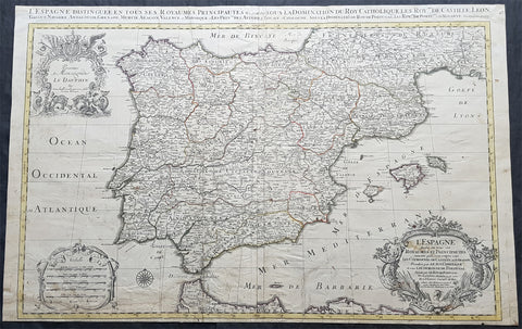
1696 Alexis Jaillot Large Antique Map of Spain, Portugal & Balearic Islands
- Title : L Espagne divisee en tous ses Royaumes et Principautes...Chez H Jaillot....1696
- Size: 36 1/2in x 23in (930mm x 585mm)
- Condition: (B) Good Condition
- Date : 1696
- Ref #: 35001
Description:
This very large, hand coloured original antique map of Spain & Portugal, by Alexis Hubert Jaillot - after Nicolas Sanson - was engraved in 1696 - the date is engraved in the title cartouche.
General Definitions:
Paper thickness and quality: - Heavy and stable
Paper color : - off white
Age of map color: - Original
Colors used: - Yellow, green, blue, pink
General color appearance: - Authentic
Paper size: - 36 1/2in x 23in (930mm x 585mm)
Plate size: - 35in x 23in (845mm x 600mm)
Margins: - Min 1/2in (12mm)
Imperfections:
Margins: - Soiling and creasing in margins
Plate area: - Light uplift along folds, soiling & creasing to bottom of map
Verso: - Soiling, creasing, old neutralised tape residue
Background:
In 1469, the crowns of the Christian kingdoms of Castile and Aragon were united by the marriage of Isabella I of Castile and Ferdinand II of Aragon. 1478 commenced the completion of the conquest of the Canary Islands and in 1492, the combined forces of Castile and Aragon captured the Emirate of Granada from its last ruler Muhammad XII, ending the last remnant of a 781-year presence of Islamic rule in Iberia. That same year, Spains Jews were ordered to convert to Catholicism or face expulsion from Spanish territories during the Spanish Inquisition. As many as 200,000 Jews were expelled from Spain. This was followed by expulsions in 1493 in Aragonese Sicily and Portugal in 1497. The Treaty of Granada guaranteed religious tolerance towards Muslims, for a few years before Islam was outlawed in 1502 in the Kingdom of Castile and 1527 in the Kingdom of Aragon, leading to Spains Muslim population becoming nominally Christian Moriscos. A few decades after the Morisco rebellion of Granada known as the War of the Alpujarras, a significant proportion of Spains formerly-Muslim population was expelled, settling primarily in North Africa. From 1609–14, over 300,000 Moriscos were sent on ships to North Africa and other locations, and, of this figure, around 50,000 died resisting the expulsion, and 60,000 died on the journey.
The year 1492 also marked the arrival of Christopher Columbus in the New World, during a voyage funded by Isabella. Columbuss first voyage crossed the Atlantic and reached the Caribbean Islands, beginning the European exploration and conquest of the Americas, although Columbus remained convinced that he had reached the Orient. Large numbers of indigenous Americans died in battle against the Spaniards during the conquest, while others died from various other causes. Some scholars consider the initial period of the Spanish conquest— from Columbuss first landing in the Bahamas until the middle of the sixteenth century—as marking the most egregious case of genocide in the history of mankind. The death toll may have reached some 70 million indigenous people (out of 80 million) in this period.
The colonisation of the Americas started with conquistadores like Hernán Cortés and Francisco Pizarro. Miscegenation was the rule between the native and the Spanish cultures and people. Juan Sebastian Elcano completed the first voyage around the world in human history, the Magellan-Elcano circumnavigation. Florida was colonised by Pedro Menéndez de Avilés when he founded St. Augustine, Florida and then defeated an attempt led by the French Captain Jean Ribault to establish a French foothold in Spanish Florida territory. St. Augustine became a strategic defensive base for Spanish ships full of gold and silver sailing to Spain. Andrés de Urdaneta discovered the tornaviaje or return route from the Philippines to Mexico, making possible the Manila galleon trading route. The Spanish once again encountered Islam, but this time in Southeast Asia and in order to incorporate the Philippines, Spanish expeditions organised from newly Christianised Mexico had invaded the Philippine territories of the Sultanate of Brunei. The Spanish considered the war with the Muslims of Brunei and the Philippines, a repeat of the Reconquista. The Spanish explorer Blas Ruiz intervened in Cambodias succession and installed Crown Prince Barom Reachea II as puppet.
As Renaissance New Monarchs, Isabella and Ferdinand centralised royal power at the expense of local nobility, and the word España, whose root is the ancient name Hispania, began to be commonly used to designate the whole of the two kingdoms. With their wide-ranging political, legal, religious and military reforms, Spain emerged as the first world power. The death of their son Prince John caused the Crown to pass to Charles I (the Emperor Charles V), son of Juana la Loca.
The unification of the crowns of Aragon and Castile by the marriage of their sovereigns laid the basis for modern Spain and the Spanish Empire, although each kingdom of Spain remained a separate country socially, politically, legally, and in currency and language.
There were two big revolts against the new Habsburg monarch and the more authoritarian and imperial-style crown: Revolt of the Comuneros in Castile and Revolt of the Brotherhoods in Majorca and Valencia. After years of combat, Comuneros Juan López de Padilla, Juan Bravo and Francisco Maldonado were executed and María Pacheco went into exile. Germana de Foix also finished with the revolt in the Mediterranean.
Habsburg Spain was Europes leading power throughout the 16th century and most of the 17th century, a position reinforced by trade and wealth from colonial possessions and became the worlds leading maritime power. It reached its apogee during the reigns of the first two Spanish Habsburgs—Charles I (1516–1556) and Philip II (1556–1598). This period saw the Italian Wars, the Schmalkaldic War, the Dutch Revolt, the War of the Portuguese Succession, clashes with the Ottomans, intervention in the French Wars of Religion and the Anglo-Spanish War.
Through exploration and conquest or royal marriage alliances and inheritance, the Spanish Empire expanded to include vast areas in the Americas, islands in the Asia-Pacific area, areas of Italy, cities in Northern Africa, as well as parts of what are now France, Germany, Belgium, Luxembourg, and the Netherlands. The first circumnavigation of the world was carried out in 1519–1521. It was the first empire on which it was said that the sun never set. This was an Age of Discovery, with daring explorations by sea and by land, the opening-up of new trade routes across oceans, conquests and the beginnings of European colonialism. Spanish explorers brought back precious metals, spices, luxuries, and previously unknown plants, and played a leading part in transforming the European understanding of the globe. The cultural efflorescence witnessed during this period is now referred to as the Spanish Golden Age. The expansion of the empire caused immense upheaval in the Americas as the collapse of societies and empires and new diseases from Europe devastated American indigenous populations. The rise of humanism, the Counter-Reformation and new geographical discoveries and conquests raised issues that were addressed by the intellectual movement now known as the School of Salamanca, which developed the first modern theories of what are now known as international law and human rights. Juan Luis Vives was another prominent humanist during this period.
Spains 16th century maritime supremacy was demonstrated by the victory over the Ottomans at Lepanto in 1571, and then after the setback of the Spanish Armada in 1588, in a series of victories against England in the Anglo-Spanish War of 1585–1604. However, during the middle decades of the 17th century Spains maritime power went into a long decline with mounting defeats against the United Provinces and then England; that by the 1660s it was struggling grimly to defend its overseas possessions from pirates and privateers.
The Protestant Reformation dragged the kingdom ever more deeply into the mire of religiously charged wars. The result was a country forced into ever expanding military efforts across Europe and in the Mediterranean. By the middle decades of a war- and plague-ridden 17th-century Europe, the Spanish Habsburgs had enmeshed the country in continent-wide religious-political conflicts. These conflicts drained it of resources and undermined the economy generally. Spain managed to hold on to most of the scattered Habsburg empire, and help the imperial forces of the Holy Roman Empire reverse a large part of the advances made by Protestant forces, but it was finally forced to recognise the separation of Portugal and the United Provinces, and eventually suffered some serious military reverses to France in the latter stages of the immensely destructive, Europe-wide Thirty Years War. In the latter half of the 17th century, Spain went into a gradual decline, during which it surrendered several small territories to France and England; however, it maintained and enlarged its vast overseas empire, which remained intact until the beginning of the 19th century.
The decline culminated in a controversy over succession to the throne which consumed the first years of the 18th century. The War of the Spanish Succession was a wide-ranging international conflict combined with a civil war, and was to cost the kingdom its European possessions and its position as one of the leading powers on the Continent. During this war, a new dynasty originating in France, the Bourbons, was installed. Long united only by the Crown, a true Spanish state was established when the first Bourbon king, Philip V, united the crowns of Castile and Aragon into a single state, abolishing many of the old regional privileges and laws.
The 18th century saw a gradual recovery and an increase in prosperity through much of the empire. The new Bourbon monarchy drew on the French system of modernising the administration and the economy. Enlightenment ideas began to gain ground among some of the kingdoms elite and monarchy. Bourbon reformers created formal disciplined militias across the Atlantic. Spain needed every hand it could take during the seemingly endless wars of the eighteenth century—the Spanish War of Succession or Queen Annes War (1702–13), the War of Jenkins Ear (1739–42) which became the War of the Austrian Succession (1740–48), the Seven Years War (1756–63) and the Anglo-Spanish War (1779–83)—and its new disciplined militias served around the Atlantic as needed.
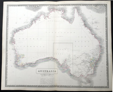
1844 W & AK Johnston Large Early Antique Map of Australia
- Title : Australia
- Date : 1844
- Condition: (A+) Fine Condition
- Ref: 30143
- Size: 25in x 21in (635mm x 535mm)
Description:
This large fine hand coloured original antique lithograph map of Australia - with coloured outlines to the counties in NSW & WA - was published by W & AK Johnston in General Atlas,1844.
At the bottom of the map is atext box outlining the period of settlements in Australia from Botany Bay in 1788, WA 1829, SA 1836 & the colony of Victoria begun some 8 years ealier in 1838.
Johnston was one of the master publishers of fine engraved and lithographed maps during the 19th century, this large map is no exception. (Ref: Tooley; M&B)
General Description:
Paper thickness and quality: - Heavy and stable
Paper color: - off white
Age of map color: - Original
Colors used: - Red, green, yellow
General color appearance: - Authentic
Paper size: - 25in x 21in (635mm x 535mm)
Plate size: - 25in x 21in (635mm x 535mm)
Margins: - Min 1/2in (12mm)
Imperfections:
Margins: - Light age toning
Plate area: - None
Verso: - None
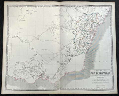
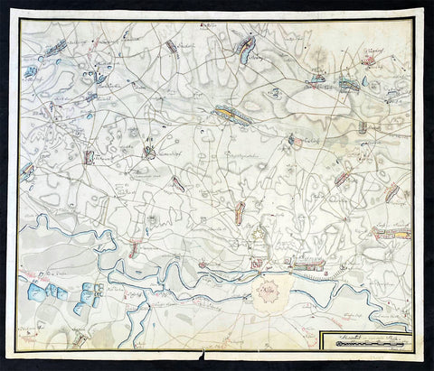
1845 Johnston Large Antique Map of New South Wales & Victoria, Australia Felix
- Title : Colony of New South Wales and Australia Felix
- Ref #: 35088
- Size: 25 1/2in x 21in (650mm x 535mm)
- Date : 1845
- Condition: (A+) Fine Condition
Description:
This large fine hand coloured original antique map of NSW & SE Australia stretching from the 10 year old Settlement of Melbourne in the south to the 31st parallel in the north, by W & AK Johnston, was published in the 1845 edition of the General Atlas.
A large, highly detailed regional map of New South Wales and Australia Felix the SE area which quickly became the state of Victoria. The map, with this title, lasted for only a few years, before both NSW and Victoria were quickly settled. The map provides a very early depiction of the region, pre-dating the discovery of gold.
Also of great interest are the exploration routes by Mitchell (1836) in Red, Tyer's & Townsend's (1840) in Yellow and Streletsky's (Strzelecki) (1840) in Blue.
The 18 counties of NSW are highlighted in beautiful hand colour with extensive detail of towns, tracks and rivers. Historical note included below the title.Decorative Piano Key border and a fine example, on thick heavy paper.
Johnston was one of the master publishers of fine engraved and lithographed maps during the 19th century - this map is no exception. (Ref: Tooley; M&B)
General Description:
Paper thickness and quality: - Heavy and stable
Paper color: - off white
Age of map color: - Original
Colors used: - Red, green, yellow
General color appearance: - Authentic
Paper size: - 25 1/2in x 21in (650mm x 535mm)
Plate size: - 25 1/2in x 21in (650mm x 535mm)
Margins: - Min 1/2in (12mm)
Imperfections:
Margins: - None
Plate area: - None
Verso: - None
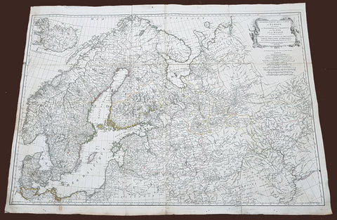
1758 D Anville Very Large Antique Map of Norway Sweden Iceland, Baltics & Russia
- Title : Seconde Partie de la Carte D Europe contenant Le Danemark et la Norwege, La Suede et la Russie....MDCCLVIII
- Size: 40 1/2in x 29 1/2in (1.02m x 760mm)
- Condition: (A) Very Good Condition
- Date : 1758
- Ref #: 92308
Description:
This scarce, very large (40in x 29in) highly detail map of Northern Europe Norway, Sweden, Lithuania, Baltic Countries and European Russia - was engraved in 1758 - dated in the title cartouche - by George De La Haye and was published by Jean Baptiste Bourguignon D\'Anville in his large elephant folio atlas Atlas Generale.
General Definitions:
Paper thickness and quality: - Heavy and stable
Paper color : - off white
Age of map color: - Original
Colors used: - Yellow, Green, pink
General color appearance: - Authentic
Paper size: - 40 1/2in x 29 1/2in (1.02m x 760mm)
Plate size: - 40in x 28 1/2in (1.0m x 725mm)
Margins: - Min 1/2in (12mm)
Imperfections:
Margins: - Light toning
Plate area: - Folds as issued, light separation at corners of folds
Verso: - Age toning
Background:
Before the fifteenth century the people of Southern Europe had little geographical knowledge of the Scandinavian World except from sketchy detail shown in the Catalan Atlas (1375) and on a number of portolani embracing Denmark and the southern tip of Norway. It was not until 1427 that a manuscript map prepared about that time by Claudius Clavus (b.1388) a Dane who spent some time in Rome, made available to scholars a tolerable outline of the northern countries and Greenland. That was to remain the best map available for the rest of the century and it was used as the basis for maps of Scandinavia in early printed editions of Ptolemy. Others by Nicolaus Cusanus (1491) and Ehrhard Etzlaub (c. 1492) followed but, needless to say, these are extremely rare; even the later maps by Olaus Magnus and Marcus Jordan, where they have survived at all , are known only by a very few examples. In fact, apart from the rare appearance of an early Ptolemy map, the oldest of Scandinavia which a collector is likely to find are those of Munster\'s Cosmograhy first published in 1544. In the following centuries the few maps and charts complied in Scandinavia were usually published in Amsterdam, Antwerp, Paris or Nuremberg, the most important maps often being incorporated in the major Dutch, French & German Atlases. (Ref: Tooley; M&B)
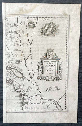
1635 Joan Blaeu Antique Half Page Map of New England, Nova Belgica et Anglia
- Title : Nova Belgica Et Anglia Nova
- Date : 1635
- Size: 18 1/2in x 12in (470mm x 305mm)
- Condition: (A) Good Condition
- Ref: 16385
Description:
This original copper-plate engraved antique half right hand page map of New England & NE America by Joan Blaeu was published in the 1635 German edition of Atlas Novus.
This is the right hand, cartouche title section of this important map.
General Definitions:
Paper thickness and quality: - Heavy and stable
Paper color : - off white
Age of map color: -
Colors used: -
General color appearance: -
Paper size: - 18 1/2in x 12in (470mm x 305mm)
Plate size: - 15 1/2in x 10in (395mm x 255mm)
Margins: - Min 1/2in (12mm)
Imperfections:
Margins: - Soiling, small worm hole top right margin
Plate area: - Light soiling, 4 small worm holes
Verso: - Light soiling
Background:
This important map was one of the most attractive of the Americas published at the time. It is noted for the fact that its primary source is the first manuscript figurative map of Adriaen Block from 1614. Indeed it is the first full representation of it in print. It is one of the earliest to name Nieu Amsterdam. Block, a Dutch fur trader, explored the area between Cape Cod and Manhattan, examining the bays and rivers along the way. This helped to create an accurate picture of the longitudinal scale of the coastline. His manuscript map is the first document to delineate an insular Manhattan; it also provides the earliest appearance of Manhates and Niev Nederland.
It has been noted that the time difference between 1614, the date of the manuscript, and Blaeus map whose first appearance is in 1635, appears long for such an important advance. It would seem highly feasible that Blaeu, who published many separately issued maps, would have wanted to produce one like this sooner. However, evidence points to the fact that it could not have been made before 1630. The Stokes Collection in New York possesses an example of the map on thicker paper without text on the reverse which could well be a proof issue of some kind.
There are features on Blaeus map that differ from the Block chart. Some of these could be accounted for by the fact that the surviving figurative map is not the original, and that the copyist omitted some place names that are referred to in the text of de Laets work. Block drew on Champlains map of 1612 for the depiction of the lake named after him, but it is here called Lacus Irocoisiensis. … The lack of interrelation between the Dutch or English colonies and the French, led for some time to the eastward displacement of this lake when its true position would be north of the Hudson River.
Some nomenclature has its origins in Blaeus second Paskaert of c.1630, and others, such as Manatthans, in de Laet. The colony of Nieu Pleimonth is identified. This and other English names along that part of the coast are largely derived from Smith\\\'s New England, 1616. Cape Cod is here improved over the Block manuscript by being reconnected to the mainland, the narrow strait having been removed. The coastline between here and Narragansett Bay, which can be clearly recognized, is not so accurate. Adriaen Blocx Eylandt leads us to the Versche Rivier, or Connecticut River, which Block ascended as far as was possible. t Lange Eyland is named; however, it is incorrectly too far east, being applied to what is possibly Fishers Island. De Groote bay marks Long Island Sound. The Hudson River is still not named as such, but is littered with Dutch settlements, and the failed Fort Nassau is here depicted renamed as Fort Orange. He does, however, improve on the direction of its flow. Blaeu separates the sources of the Hudson and Delaware Rivers which had been causing some confusion. Nieu Amsterdam is correctly marked as a fort at the tip of an island separated on the east side by Hellegat, or the East River. The coastline south of Sandy Hook also shows signs of improvement.
The whole map is adorned by deer, foxes, bears, egrets, rabbits, cranes and turkeys. Beavers, polecats and otters appear on a printed map for the first time. The Mohawk Indian village top right is derived from the de Bry-White engravings.
1755 Kloch Antique Original Hand Drawn Manuscript Military Map of Nysa Poland.
- Title : (Neisse) Nysa
- Ref #: 35639
-
Condition: (A+) Fine Condition
- Size: 21 3/4in x 18in (557mm x 460mm)
- Date : 1755-60
- Price: $575US
Description:
A wonderful large unique, original antique hand drawn military manuscript map on laid 18th century paper with a large French Imperial Fleur De Lis watermark.
This original unique hand drawn, hand coloured antique military map of the fortifications around the City and villages of the ancient Silesian city of Niessa or Nysa, now situated mainly in Poland with parts in Germany & Czech Republic, was hand drawn by a Prussian Military Cartographer Kloch, name inscribed in scale cartouche, was drawn in the mid to late 1750s, as it includes the Nysa fortifications known as Fort Prussia built between 1743-45.
General Definitions:
Paper thickness and quality: - Heavy and stable
Paper color : - off white
Age of map color: - Original
Colors used: - Yellow, green, blue, pink
General color appearance: - Authentic
Paper size: - 21 3/4in x 18in (557mm x 460mm)
Plate size: - 21 3/4in x 18in (557mm x 460mm)
Margins: - Min 1/2in (12mm)
Imperfections:
Margins: - Small section missing from bottom margin into border.
Plate area: - None
Verso: - Several small tears repaired to margins, not affecting the image
Background:
During the mid-18th century, the city of Nysa (Neisse) in Silesia, now located in present-day Poland, was a significant strategic location that witnessed several sieges between the Prussian and Austrian forces. The sieges were part of the larger conflict known as the War of the Austrian Succession (1740-1748) and the subsequent Seven Years' War (1756-1763).
The first major siege of Nysa occurred in 1741 during the War of the Austrian Succession. The Prussian army, led by King Frederick II (Frederick the Great), laid siege to the city, which was held by Austrian forces. The Prussian forces employed siege tactics, such as constructing trenches, artillery bombardment, and attempts to breach the city's defenses. After a protracted period of resistance, the Austrians eventually surrendered, and Nysa fell into Prussian control.
However, the city changed hands several times during the subsequent years of conflict. In 1742, as part of the Treaty of Breslau, Nysa was returned to Austrian control. But in 1745, during the Second Silesian War, the Prussians launched another siege and recaptured the city, fortifying it as a crucial stronghold in their territorial ambitions.
The city experienced further sieges during the Seven Years' War, which began in 1756. In 1758, the Austrian army, under the command of General Ernst Gideon von Laudon, laid siege to Nysa in an attempt to retake it from the Prussians. The siege lasted for several months, with both sides engaging in fierce combat and extensive bombardment. However, the Prussian defenders managed to hold their ground, and the Austrians eventually lifted the siege without capturing the city.
The sieges of Nysa in the mid-18th century were characterized by the use of traditional siege warfare techniques, including the construction of trenches, siege towers, and the deployment of artillery. The defending forces within the city would have employed various defensive measures, such as reinforcing the fortifications, counter-battery fire, and attempting to repel any breaches made by the besiegers.
These sieges played a significant role in the broader context of the conflicts between Prussia and Austria over control of Silesia. They showcased the strategic importance of Nysa and the determination of both sides to gain control of this key stronghold. The sieges of Nysa during this period serve as a testament to the military tactics and strategies employed by the Prussian and Austrian forces and the hardships faced by the soldiers and civilians caught in the midst of these conflicts.
Please note all items auctioned are genuine, we do not sell reproductions. A Certificate of Authenticity (COA) can be issued on request.
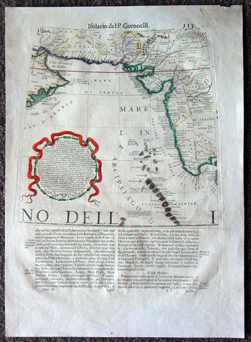
1696 Coronelli Antique Map, Globe Gore, of India, Pakistan, Iran, Persian Gulf
- Title : Isolario del P. Coronelli
- Date : 1696
- Condition: (A+) Fine Condition
- Ref: 42007
- Size: 19 1/2in x 14in (495mm x 355mm)
Description:
This is a rare opportunity to acquire an original antique Globe Gore of India and parts of the Middle East& Persia by Vincenzo Coronelli published in his 1696 edition ofIsolario dell' Atlante Veneto.
The copper-plates for these gores were originally engraved by Coronelli for the construction of the large 42in (110cm) terrestrial globe.
Coronelli published 2 different globe gore atlases, the 1693 edition of Libero dei Globiand the 1696 edition of Isolario dell' Atlante Veneto. The difference being the inclusion of Latin text to the latter publication.
Background:
In the early 1680’s Vincenzo Coronelli constructed two vast 15ft diameter terrestrial & celestial globes for Louis XIV of France. These were meticulously hand drawn & engraved. Such was the admiration of these Globes that in 1688 Coronelli began the engraving & publication of Globe Gores for the construction of two 110cm (42in) terrestrial & celestial globes.
Coronellis claim to have produced the best globes of any age was exemplified by the high demand and purchase of the globes by various institutions & cities within Europe. Yet many scholars still did not have the opportunity to visit Paris, London, Rome or Venice to view them and so Coronelli devised his famous atlas Libero dei Globi the first atlas of globe gores ever produced. The Libroformed part of a great series of atlases by Coronelli, the Atlante Veneto, in which Coronelli was able to combine the two cartographic art forms in which he excelled, maps & globes.
The engraving of the gores was of the highest standard with neat contrasting lettering and five large cartouches of a singular grace and elegance. One cartouche situated below Australia carries a portrait of the author and Pope Alexander VI.
Some of the more interesting features contained within the Gores are the recording of recent French explorations in North America, such as La Salles journey to the mouth of the Mississippi in 1681-87 & the French possessions within North America. Elsewhere the Caspian Sea is drawn closer to its modern shape, the Nile in Africa is shown without its fictitious source and the Blue Nile is shown correctly from a large lake in Ethiopia. The tracks of Le Maire crossing of the Pacific in 1616 are marked, as is the voyage of Chaumont to Siam in 1685-6. There are an unusual number of legends, all explanatory and informative along with many vignettes of ships and fishing scenes throughout the globe.
Coronelli was one of the finest engravers & cartographers of any era, producing some of the most stunning work ever seen. These Globe Gores are no exception. Coronelli was a master craftsman with an eye for detail. You can feel the uncompromising accuracy & passion in his work when you study his maps & globes.
These globe gores are scarce, with only a few sales records from the last 25 years. Similarly there is very little choice currently on the market. This scarcity ensures ongoing value and future appreciation. (Ref: Shirley 538; Tooley; Dr. Helen Wallis The Map Collector Dec 1980;Armao, Ermanno. Vincenzo Coronelli Cenni sull'uomo e la sua Vita Catalogo... Bibliopolis, Florence pp.130-134)
General Description:
Paper thickness and quality: - Heavy and stable
Paper color: - white
Age of map color: - Early
Colors used: - Green, yellow, pink, red
General color appearance: - Fresh
Paper size: - 19 1/2in x 14in (495mm x 355mm)
Plate size: - 11 1/2in x 11in (295mm x 280mm)
Margins: - min. 1/2in (12mm)
Imperfections:
Margins: - None
Plate area: - None
Verso: - None
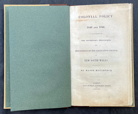
1841 Macarthur Antique Octavo Book on Colonial Policy in Australia, Map of NSW
- Title : Colonial Policy of 1840 and 1841, as illustrated by the Governor's Despatches, and Proceedings of the Legislative Council of New South Wales. By Major Macarthur.
- Ref #: 17045
- Size: Octavo
- Date : 1841
- Condition: (A+) Fine Condition
Description:
Fine original antique Octavo book with 79 pages and a single lithographed hand coloured map of eastern Australia & Van Diemens Land; uncut copy in half calf with gilt lettering by Edward Macarthur, advocating for immigration and trade for the colony of Australia, published by John Murray, London in 1841, dated.
This is the first of two books by Sir Edward Macarthurs advocating immigration to the colony of Australia. The eldest son of John and Elizabeth, Edward Macarthur was born at Bath in 1789, and accompanied his parents to New South Wales in 1790. As one of the first free settlers in the colony, he was a strong advocate of immigration, and served as Thomas Macqueens agent in arranging the first shipment of free immigrants in 1824, which gave great stimulus to agriculture.
The map illustrates a division of New South Wales and the subsequent creation of a smaller colony. Titled Eastern Australia or Territory of New South Wales, the map is captioned 'territory to which the Colony might be reduced by Bill of the last session' with reference debate in the House of Commons knocked down by Sir Robert Peel.
General Definitions:
Paper thickness and quality: - Heavy and stable
Paper color : - off white
Age of map color: - Original
Colors used: - Yellow
General color appearance: - Authentic
Paper size: - Octavo
Plate size: - Octavo
Margins: - Octavo
Imperfections:
Margins: - None
Plate area: - None
Verso: - None
Background:
Sir Edward Macarthur (1789-1872), soldier, was born on 16 March 1789 at Bath, England, the eldest son of Captain John Macarthur and his wife Elizabeth. He went to Sydney with his parents in 1790 and spent his boyhood there and at Elizabeth Farm, Parramatta. Sent to England in 1799 to be educated he returned to Sydney in 1806. With his father he took part in the deposition of Governor William Bligh in 1808. He soon left for London taking his father's version of the rebellion and the first bale of merino wool to be exported from the colony. He obtained a commission in the 60th Regiment and served at Corunna and in Sicily. As a lieutenant in the 39th Regiment he took part in Wellington's campaigns of 1812-14 and was present at Vittoria, the Pyrénées and the battles in southern France. After brief service in Canada he joined the army of occupation in France.
In 1824 Macarthur went to New South Wales as the agent of T. P. Macqueen. He was impressed by the dispersion of the garrison from Moreton Bay to Hobart Town in the face of runaway convicts and 'hostile tribes'. In London he placed detailed proposals for a colonial militia before Under-Secretary Horton but the plan was rejected by Governor (Sir) Ralph Darling in 1827. Macarthur competently represented Australian interests in London. He presented a petition from New South Wales in 1840. He advocated emigration in two small books, Colonial Policy of 1840 and 1841, as Illustrated by the Governor's Despatches, and the Proceedings of the Legislative Council of New South Wales (London, 1841) and Brief Remarks on Colonization (London, 1846). He personally arranged the migration of German vinedressers to the Macarthur properties at Camden and also sought to develop coastal steamship services. After serving as secretary in the Lord Chamberlain's Office in 1843-46 he was on the military staff in Ireland. In 1851 he was posted to Sydney as deputy adjutant general. Promoted colonel in 1854, he moved with the headquarters to Melbourne. He accompanied the commander-in-chief, Major-General Sir Robert Nickle, to Eureka on 5 December. They talked freely with the miners and as a result of their investigations Nickle advised that martial law be withdrawn.
After Nickle died in May 1855 and Governor Hotham in December, Macarthur took over command of the forces and became administrator. He inherited a confused political situation and was coolly received by the press. However, his impartiality and his willingness to leave things to his ministers helped him, and when he handed over to Sir Henry Barkly on 23 December 1856 he had won the esteem of parliament and the people of Melbourne. Emily, wife of Hugh Childers, described him as 'if not a brilliant statesman, an industrious, kind-hearted, Christian gentleman'. In 1858 Macarthur chaired a royal commission on the defences of the colony. In 1860 he returned to England and was appointed K.C.B. in 1862. In that year he married Sarah (d.1889), daughter of Lieutenant-Colonel W. S. Neill. Promoted lieutenant-general in 1866, he died childless in London on 4 January 1872 and was buried in the Brompton cemetery. He was survived by his wife. His goods were valued for probate at £4000.
Macarthur, Edward (1789 - 1872)
Macarthur was a lieutenant-general in the British Army, Commander-in-chief of British forces in Australia from 1855, and an administrator of the Colony of Victoria for 12 months, following the death of the Governor, Sir Charles Hotham.
Macarthur was the eldest son of John Macarthur, and his wife Elizabeth (née Veal). He was born at Bath, Somerset, England, and arrived at Sydney with his parents in the ships Neptune and Scarborough in 1790, part of the Second Fleet. Edward Macarthur is believed to be the only passenger on those ships of whom a photograph exists, although taken later in life. In 1799, the young Edward was sent to England to be educated.
Macarthur returned to Australia in 1806 and took part with his father in the deposing of Governor William Bligh. Bligh, in his dispatch to Viscount Castlereagh of 30 April 1808, requested that two of the rebels Charles Grimes and Edward Macarthur who have gone home in the Dart may be secured, in order to be tried in due time. On Macarthurs arrival in England, he entered the army as an ensign in the 60th regiment, serving at Corunna and in Sicily. In 1809, he was promoted to the rank of lieutenant. As part of the 39th Regiment he took part in the Duke of Wellingtons campaigns in the Peninsular War and in France. In 1820 or 1829 he became a captain. In 1824 he paid a visit of 10 months to Australia as an agent of Thomas Potter Macqueen. After Macarthurs return to England, he was for some years secretary to the Lord Chamberlain. In 1826 he was promoted to the rank of major and in 1837 he was on the staff in Ireland.
Macarthur retained his interest in Australia. On 3 July 1839, he addressed a long communication to the Right Hon. Henry Labouchère, suggesting that regular lines of steamers should be established in Australia to trade between the various ports. That was referred to the governor, Sir George Gipps who, in May 1840, replied that government aid was unnecessary, because a large company had been formed to establish a line of steamers, of which James Macarthur (Edwards brother) was chairman. Edward Macarthur also promoted emigration in two small books: Colonial Policy of 1840 and 1841, as Illustrated by the Governors Despatches, and the Proceedings of the Legislative Council of New South Wales (London, 1841) and Brief Remarks on Colonization (London, 1846).
In August 1840, Macarthur protested against the regulations that people wanting to take up land in the Port Phillip district should have to proceed to Melbourne where all charts of land were kept for public inspection. He was made a Lieutenant-Colonel in 1841, and afterwards went to New South Wales as deputy adjutant-general. He was promoted to colonel in 1854.
On 5 December 1854, Macarthur travelled with the commander-in-chief of British forces in Australia, Major-General Sir Robert Nickle, to the site of the Eureka Rebellion. There they talked with the miners openly and, as a result of their investigations, Nickle advised the withdrawal of martial law. Macarthur was appointed commander-in-chief of British forces in Australia in 1855, to replace Nickle. On 1 January 1856, after the death of Governor of Victoria, Sir Charles Hotham, Macarthur was administrator of the colony of Victoria for 12 months.
Macarthur returned to London in 1860. In 1862, he was created a Knight Commander of the KCB and, in the same year, was given the colonelcy of the 100th (Prince of Waless Royal Canadian) Regiment of Foot, a position he held until his death.
He died in London on 4 January 1872 and was buried in Brompton Cemetery. In 1862, at the age of 73, he had married Sarah (daughter of Lieutenant-Colonel W. S. Neill), who survived him. There were no children.
Please note all items auctioned are genuine, we do not sell reproductions. A Certificate of Authenticity (COA) can be issued on request.
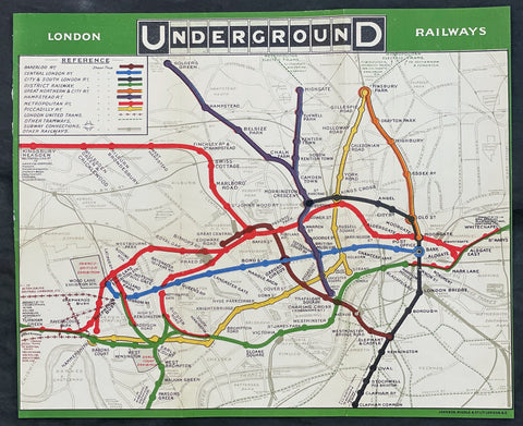
1908 UERL Johnson & Riddle Antique London Underground Map Rare 2nd Map Published
- Title : London Underground Railways
- Ref #: 17054
- Size: 13 3/4in x 11 1/2in (352mm x 290mm)
- Date : 1908
- Condition: (A+) Fine Condition
Description:
This original early scarce antique folding, pocket map of The London Underground, only the second combined map, by The Underground Electric Railways Company of London (UERL) was published by Johnson, Riddle & co. in 1908.
The first map was published a year earlier by The Evening News in 1907.
This geographic paper edition of the Underground map shows the Railway lines belonging to the Underground Group as well as the Central London Railway and Metropolitan Railway lines. Each line is represented by a different colour, other railways are marked with lighter black lines, London United tramways are shown by lines of crosses and other tramways routes are marked with a broken line. General geographic features such as roads and parks are also included. Earl's Court Exhibition Ground is marked on this map as well as the Franco-British Exhibition at Shepherd's Bush. This map has a green border and the UndergrounD logo is used in the map title.
General Definitions:
Paper thickness and quality: - Heavy and stable
Paper color : - off white
Age of map color: - Original
Colors used: - Yellow, green, blue, pink
General color appearance: - Authentic
Paper size: - 13 3/4in x 11 1/2in (352mm x 290mm)
Plate size: - 13 3/4in x 11 1/2in (352mm x 290mm)
Margins: - Min 1/8in (2mm)
Imperfections:
Margins: - Folds as issued
Plate area: - Folds as issued
Verso: - Folds as issued
Background:
As Londons early transport system was operated by a variety of independent companies, there were no complete maps of the network, just for the individual companies routes. The maps were not typically schematic and were simply the line overlaid on a regular city map. There was no integration of the companies services or any co-operation in advertising.
In 1907, The Evening News commissioned a pocket map, The Evening News London Tube Map. It was the first map to show all of the lines with equal weight being given to each line, and it was the first map to use a different colour for each line.
Another early combined map was published in 1908 by the Underground Electric Railways Company of London (UERL) in conjunction with four other underground railway companies that used the Underground brand as part of a common advertising factor.
The map showed eight routes – four operated by the UERL and one from each of the other four companies:
UERL lines:
Bakerloo Railway – brown
Hampstead Railway – indigo
Piccadilly Railway – yellow
District Railway – green
Other lines:
Central London Railway – blue
City and South London Railway – black
Great Northern and City Railway – orange
Metropolitan Railway – red
A geographical map presented restrictions since for sufficient clarity of detail in the crowded central area of the map required the extremities of the District and Metropolitan lines to be omitted and so a full network diagram was not provided. The problem of truncation remained for nearly half a century. Although all of the western branches of the District and Piccadilly lines were included for the first time in 1933 with Harry Becks first proper Tube map, the portion of the Metropolitan line beyond Rickmansworth did not appear until 1938, and the eastern end of the District line did not appear until the mid-1950s.
The route map continued to be developed and was issued in various formats and artistic styles until 1920, when, for the first time, the geographic background detail was omitted in a map designed by MacDonald Gill. That freed the design to enable greater flexibility in the positioning of lines and stations. The routes became more stylised but the arrangement remained, largely, geographic in nature. The 1932 edition was the last geographic map to be published before Becks diagrammatic map was introduced.
The first diagrammatic map of Londons rapid transit network was designed by Harry Beck in 1931. He was a London Underground employee who realised that because the railway ran mostly underground, the physical locations of the stations were largely irrelevant to the traveller wanting to know how to get from one station to another; only the topology of the route mattered. That approach is similar to that of electrical circuit diagrams although they were not the inspiration for Becks map. His colleagues pointed out the similarities, however, and he once produced a joke map with the stations replaced by electrical circuit symbols and names, with terminology such as Bakerlite for the Bakerloo line.
To that end, Beck devised a simplified map with stations, straight-line segments connecting them, and the River Thames; and lines running only vertically, horizontally, or on 45° diagonals. To make the map clearer and to emphasise connections, Beck differentiated between ordinary stations, marked with tick marks, and interchange stations, marked with diamonds. London Underground was initially sceptical of his proposal since it was an uncommissioned spare-time project and was tentatively introduced to the public in a small pamphlet in 1933. However, it immediately became popular, and the Underground has used topological maps to illustrate the network ever since.
Despite the complexity of making the map, Beck was paid just ten guineas for the artwork and design of the card edition (five guineas for the poster). After its initial success, he continued to design the Tube map until 1960, a single (and unpopular) 1939 edition by Hans Scheger being the only exception. Meanwhile, as well as accommodating new lines and stations, Beck continually altered the design, such as changing the interchange symbol from a diamond to a circle and altering the line colours of the Central line from orange to red and of the Bakerloo line from red to brown. Becks final design, in 1960, bears a strong resemblance to the current map. Beck lived in Finchley, North London, and one of his maps is still preserved on the southbound platform at Finchley Central station, on the Northern line.
In 1997, Becks importance was posthumously recognised, and as of 2021, this statement is printed on every Tube map: This diagram is an evolution of the original design conceived in 1931 by Harry Beck.
The Underground Electric Railways Company of London Limited (UERL)
The Underground Electric Railways Company of London Limited (UERL), known operationally as the Underground for much of its existence, was established in 1902. It was the holding company for the three deep-level tube underground railway lines opened in London during 1906 and 1907: the Baker Street and Waterloo Railway, the Charing Cross, Euston and Hampstead Railway and the Great Northern, Piccadilly and Brompton Railway. It was also the parent company from 1902 of the District Railway, which it electrified between 1903 and 1905. The UERL is a precursor of today's London Underground; its three tube lines form the central sections of today's Bakerloo, Northern and Piccadilly lines.
The UERL struggled financially in the first years after the opening of its lines and narrowly avoided bankruptcy in 1908 by restructuring its debt. A policy of expansion by acquisition was followed before World War I, so that the company came to operate the majority of the underground railway lines in and around London. It also controlled large bus and tram fleets, the profits from which subsidised the financially weaker railways. After the war, railway extensions took the UERL's services out into suburban areas to stimulate additional passenger numbers, so that, by the early 1930s, the company's lines stretched beyond the County of London and served destinations in Middlesex, Essex, Hertfordshire and Surrey.
In the 1920s, competition from small unregulated bus operators reduced the profitability of the road transport operations, leading the UERL's directors to seek government regulation. This led to the establishment of the London Passenger Transport Board in 1933, which absorbed the UERL and all of the independent and municipally operated railway, bus and tram services in the London area.
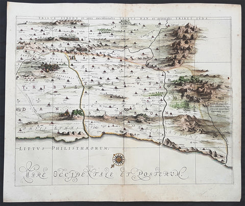
1662 Hornius & Jansson Antique Holy Land Map of the Tribes of Simeon, Dan & Juda
- Title : Tribus Simeon et pars meridionalis Tribus Dan, et Oriemtalis Tribus Juda
- Ref #: 50600
- Size: 23 1/2in x 17in (595mm x 435mm)
- Date : 1662
- Condition: (A+) Fine Condition
Description:
This large, important & scarce hand coloured original copper-plate engraved antique map one of six, of the Tribes of Simeon, Dan, & Juda, located to the South West of the Dead Sea was published by Jan Jansson & Georguis Hornius (1620-1670) in the 1662 French Edition of Atlas Major and was based on the 1590 map of Christian van Adricham, Situs Terrae Promissionis.
This map is #6 of 6 published by Jansson that combined measures 66in long by 37in wide (1.68m x 940mm) Please see the B&W image to see combined maps.
The six panels are individually titled:
Tribus Ruben, et Gad et partes orientales tribuum Beniamin, Ephraim, et dimidiae Manasse intra Iordenem. This is usually thought to the be the first panel in the series. It includes several vignettes, such as Jesus and Satan arguing on a mountaintop, Moses looking across the Jordan, the entry point of the Hebrews into the land of Milk and Honey, and a stairway ascending to heaven. This panel shows the lands controlled by Ruben and Gad, as well as the eastern lands of Benjamin, Ephraim, and part of Manasseh beyond the Jordan River. It also shows the western part of the Dead Sea.
Tribuum Ephraim, Beniamin, et Dimidiae Manasse intra Iordanem partes occidentales, et partes septentrionales Dan et Iuda. This second panel shows the lands of Ephraim, Benjamin, and part of Manasseh beyond the Jordan river. More Biblical scenes include a scene where Jonas is cast from a sailing ship into the open jaws of a whale. Also, the panel shows the lands of Palestine and numerous armies.
Tribus Aser, et partes occidentales tribuum Zabulon et Isachar. One of two enlarged panels in this series, this map shows the lands of Asher and the western reaches of Zebulon and Issachar. More Biblical illustrations include St. George and the Dragon, the city of Tyre, Nazareth, and the Tabernacle of Abraham.
Dimidia Tribus Manasse Ultra Iordanem, Tribus Neptalim et partes orientales tribuum Zabulon et Isachar. The second enlarged panel details the parts of Manasseh lying on the western shores of the Jordan River, the tribe of Naphtali, and parts of the lands of Zebulon and Issachar. This sheet includes the Sea of Galilee (Lake Tiberius), as well as several scenes from the life of Jesus, such as his walking on water, Jesus preaching from onboard a boat, and other. The large inset map in the upper left quadrant, entitled Peregrinatio Abrahae, shows the route followed by Abraham from Ur into Canaan.
Pars maxima Tribus Iusa Versus Orientem. This southeastern-most sheet depicts much of the Dead Sea, as well as the lands claimed by the tribe of Judah. It also features the smoking ruins of Sodom, Gomorrah, Adaima, and Seboim. In the upper right, there is a large inset, Itinera et Mansiones Deserti, which shows the route taken by the Hebrews as they fled from Egypt. Finally, it also shows the parting of the Red Sea.
Tribus Simeon et pars meridionalis Tribus Dan, et orientalis Tribus Idua. Usually considered the last in the series, this panel is mountainous, depicting the lands of Simeon, as well as parts of Dan and Judah. It also identifies the lands of the Philistines and timber lands rich in cedar.
General Definitions:
Paper thickness and quality: - Heavy and stable
Paper color : - off white
Age of map color: - Early
Colors used: - Yellow, pink
General color appearance: - Authentic
Paper size: - 23 1/2in x 17in (595mm x 435mm)
Plate size: - 16in x 12in (405mm x 315mm)
Margins: - Min 1in (25mm)
Imperfections:
Margins: - Light spotting in margins
Plate area: - None
Verso: - None
Background:
Jan Jansson based his map on Christian van Adrichams Situs Terrae Promissionis of ca. 1590. This version is both expanded and carries additional vignettes and details. Georgius Hornius wrote the text that accompanied the map in volume six of Janssons Novus Atlas, Accuratissimia Orbis Antiqui Delineatio.
The map shows the region divided into domains of the Twelve Tribes of Israel on both sides of the Jordan River, with the shoreline running from Sidon to Alexandria. The Cison Torrens (Kishon River) is shown as connecting the Sea of Galilee with the Mediterranean Sea, and there are many rivers, some of which do not exist; for example, there is a river connecting Jerusalem with the Dead Sea. In the Dead Sea, four burning cities are shown: Sodom, Gomorra, Seboim, and Adama.
The map is intricately engraved to show topographical features, major roads, towns and villages. It is also richly embellished with dozens of biblical illustrations. Inset maps in the top corners depict Abrahams journey (left) and the wandering of the Israelites through the desert (right).
Maps of the Holy Land, a popular genre in the early modern period, allowed users to better understand events from religious traditions. For the mapmaker, the relationship between religion and geography acted as a powerful storytelling tool, allowing viewers to spatialize religious stories. The maps show the centrality of religion to early modern European culture, as well as an enduring interest in historical geography.
According to the Hebrew Bible, the Twelve Tribes of Israel, shown here, descended from the twelve sons of Jacob. According to Deuteronomy, the twelve sons were Reuben, Simeon, Judah, Issachar, Zebulun, Benjamin, Dan, Naphtali, Gad, Asher, Ephraim, and Manasseh..
In the tenth century BCE, the Israelites made up of about 300 highland villages with a population of approximately 40,000 people. These villages would begin to conglomerate in the ninth century BCE. The kingdom formed by their joining was referred to by its neighbors as the House of David. After the kingdoms of Samaria and Judah were destroyed, the resulting Babylonian captivity caused a merging of the south Levantine groups into a unified cultural identity.
This unified kingdom would ultimately not last, however. Tensions between the tribes of Israel mounted over a disagreement as to the location of the mountain on which Moses attempted to sacrifice Isaac. Eventually, the tensions exploded when the Hasmonean King destroyed the temple of another tribe, which caused the lower Levant to devolve into chaos. This civil conflict would last until the Roman Empire invaded, with future emperor Vespasian leading an army into Israel under the pretense of restoring order. This resulted in Roman dominance over the lower Levant until the Muslim conquests of the seventh century CE.
Although published by Jan Jansson, the map was made in collaboration with Georgius Hornius (1620-1670). Indeed, it is often called the Hornius Map. Hornius was a renowned cartographer and historian who published maps as well. His family was forced to flee to Nuremberg during the religious violence of the Thirty Years War. He would eventually attend the University of Altdorf, studying religion and medicine there.
Horniuss first notable work was a history of the English Civil War, which he witnessed firsthand as a traveler. In 1648 he completed his doctorate in Leiden; by this time, his historical works had drawn the attention of many universities which sought him as a professor. He eventually decided to accept a professorship at the University of Harderwijk where he quickly became rector in 1652, a position he would hold until his death in 1670.
Horniuss historical works were influential, propagating the idea of universal history, which was an understanding of history as a whole, concurrent unit. He also prepared the text for portions of Janssons Novus Atlas, Accuratissimia Orbis Antiqui Delineatio, including the text that accompanied this map. Horniuss works would continue to be relevant after his death, with many posthumous editions of his writings published.
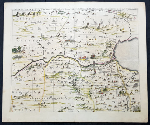
1662 Hornius & Jansson Antique Holy Land Map Tribes Ruben, Gad, Benjamin, Ephraim & Manasseh
- Title : Tribus Ruben, et Gad parties orientales tribumum Beniamin, Ephraim, et Dimidiae, Manasse, intra Jordanem
- Ref #: 61037
- Size: 24in x 20in (610mm x 510mm)
- Date : 1662
- Condition: (A+) Fine Condition
Description:
This large, important & scarce hand coloured original copper-plate engraved antique map, one of six, of the Tribes of Ruben, Gad, Benjamin, Ephraim & Manasseh located to the north and east of the Dead Sea was published by Jan Jansson & Georguis Hornius (1620-1670) in the 1662 French Edition of Atlas Major, based on the 1590 map of Christian van Adricham, Situs Terrae Promissionis.
This map is #1 of 6 published by Jansson that combined measures 66in long by 37in wide (1.68m x 940mm) Please see the B&W image to see combined maps.
Tribus Ruben, et Gad et partes orientales tribuum Beniamin, Ephraim, et dimidiae Manasse intra Iordenem. This is usually thought to the be the first panel in the series. It includes several vignettes, such as Jesus and Satan arguing on a mountaintop, Moses looking across the Jordan, the entry point of the Hebrews into the land of Milk and Honey, and a stairway ascending to heaven. This panel shows the lands controlled by Ruben and Gad, as well as the eastern lands of Benjamin, Ephraim, and part of Manasseh beyond the Jordan River. It also shows the western part of the Dead Sea.
General Definitions:
Paper thickness and quality: - Heavy and stable
Paper color : - off white
Age of map color: - Original
Colors used: - Yellow, green, blue, pink
General color appearance: - Authentic
Paper size: - 24in x 20in (610mm x 510mm)
Plate size: - 22in x 17 1/2in (560mm x 445mm)
Margins: - Min 1in (25mm)
Imperfections:
Margins: - None
Plate area: - None
Verso: - None
Background:
Jan Jansson based his map on Christian van Adrichams Situs Terrae Promissionis of ca. 1590. This version is both expanded and carries additional vignettes and details. Georgius Hornius wrote the text that accompanied the map in volume six of Janssons Novus Atlas, Accuratissimia Orbis Antiqui Delineatio.
The map shows the region divided into domains of the Twelve Tribes of Israel on both sides of the Jordan River, with the shoreline running from Sidon to Alexandria. The Cison Torrens (Kishon River) is shown as connecting the Sea of Galilee with the Mediterranean Sea, and there are many rivers, some of which do not exist; for example, there is a river connecting Jerusalem with the Dead Sea. In the Dead Sea, four burning cities are shown: Sodom, Gomorra, Seboim, and Adama.
The map is intricately engraved to show topographical features, major roads, towns and villages. It is also richly embellished with dozens of biblical illustrations. Inset maps in the top corners depict Abrahams journey (left) and the wandering of the Israelites through the desert (right).
Maps of the Holy Land, a popular genre in the early modern period, allowed users to better understand events from religious traditions. For the mapmaker, the relationship between religion and geography acted as a powerful storytelling tool, allowing viewers to spatialize religious stories. The maps show the centrality of religion to early modern European culture, as well as an enduring interest in historical geography.
According to the Hebrew Bible, the Twelve Tribes of Israel, shown here, descended from the twelve sons of Jacob. According to Deuteronomy, the twelve sons were Reuben, Simeon, Judah, Issachar, Zebulun, Benjamin, Dan, Naphtali, Gad, Asher, Ephraim, and Manasseh..
In the tenth century BCE, the Israelites made up of about 300 highland villages with a population of approximately 40,000 people. These villages would begin to conglomerate in the ninth century BCE. The kingdom formed by their joining was referred to by its neighbors as the House of David. After the kingdoms of Samaria and Judah were destroyed, the resulting Babylonian captivity caused a merging of the south Levantine groups into a unified cultural identity.
This unified kingdom would ultimately not last, however. Tensions between the tribes of Israel mounted over a disagreement as to the location of the mountain on which Moses attempted to sacrifice Isaac. Eventually, the tensions exploded when the Hasmonean King destroyed the temple of another tribe, which caused the lower Levant to devolve into chaos. This civil conflict would last until the Roman Empire invaded, with future emperor Vespasian leading an army into Israel under the pretense of restoring order. This resulted in Roman dominance over the lower Levant until the Muslim conquests of the seventh century CE.
Although published by Jan Jansson, the map was made in collaboration with Georgius Hornius (1620-1670). Indeed, it is often called the Hornius Map. Hornius was a renowned cartographer and historian who published maps as well. His family was forced to flee to Nuremberg during the religious violence of the Thirty Years War. He would eventually attend the University of Altdorf, studying religion and medicine there.
Horniuss first notable work was a history of the English Civil War, which he witnessed firsthand as a traveler. In 1648 he completed his doctorate in Leiden; by this time, his historical works had drawn the attention of many universities which sought him as a professor. He eventually decided to accept a professorship at the University of Harderwijk where he quickly became rector in 1652, a position he would hold until his death in 1670.
Horniuss historical works were influential, propagating the idea of universal history, which was an understanding of history as a whole, concurrent unit. He also prepared the text for portions of Janssons Novus Atlas, Accuratissimia Orbis Antiqui Delineatio, including the text that accompanied this map. Horniuss works would continue to be relevant after his death, with many posthumous editions of his writings published.
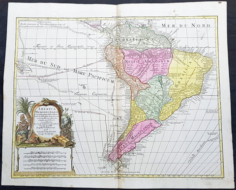
1772 Tobias Lotter Large Antique Map of South America, Magellan, Drake, Le Maire
- Title : America Meridionalis ...Tobiam Conr. Lotter...1772
- Date : 1772
- Size: 25 1/2in x 21in (650mm x 535mm)
- Ref #: 61139
- Condition: (A+) Fine Condition
Description:
This large original beautifully hand coloured copper plate engraved antique map of South America was engraved by Gustav Conrad Lotter in 1772 - dated at the foot of the map - and published by his father Tobias Conrad Lotter.
The map shows the routes of the voyages by various famous explorers to South America including: Magellan (1520), Drake (1577), le Maire & Schouten (1616), Sarmineto (1570) and others. The map also illustrates various river systems and other speculative information about the unexplored interior of the Continent. (Ref: Tooley, M&B)
General Definitions:
Paper thickness and quality: - Heavy and stable
Paper color : - off white
Age of map color: - Original
Colors used: - Blue, pink, red, green, yellow
General color appearance: - Authentic
Paper size: - 25 1/2in x 21in (650mm x 535mm)
Plate size: - 23 1/2in x 19 1/2in (595mm x 495mm)
Margins: - Min 1in (25mm)
Imperfections:
Margins: - None
Plate area: - None
Verso: - None
Background:
In 1494, Portugal and Spain, the two great maritime European powers of that time, on the expectation of new lands being discovered in the west, signed the Treaty of Tordesillas, by which they agreed, with the support of the Pope, that all the land outside Europe should be an exclusive duopoly between the two countries.
The treaty established an imaginary line along a north-south meridian 370 leagues west of the Cape Verde Islands, roughly 46° 37\\\\\\\\\\\\\\\\\\\\\\\\\\\\\\\\\\\\\\\\\\\\\\\\\\\\\\\\\\\\\\\' W. In terms of the treaty, all land to the west of the line (known to comprise most of the South American soil) would belong to Spain, and all land to the east, to Portugal. As accurate measurements of longitude were impossible at that time, the line was not strictly enforced, resulting in a Portuguese expansion of Brazil across the meridian.
Beginning in the 1530s, the people and natural resources of South America were repeatedly exploited by foreign conquistadors, first from Spain and later from Portugal. These competing colonial nations claimed the land and resources as their own and divided it in colonies.
European infectious diseases (smallpox, influenza, measles, and typhus) – to which the native populations had no immune resistance – caused large-scale depopulation of the native population under Spanish control. Systems of forced labor, such as the haciendas and mining industry\\\\\\\\\\\\\\\\\\\\\\\\\\\\\\\\\\\\\\\\\\\\\\\\\\\\\\\\\\\\\\\'s mita also contributed to the depopulation. After this, African slaves, who had developed immunities to these diseases, were quickly brought in to replace them.
The Spaniards were committed to converting their native subjects to Christianity and were quick to purge any native cultural practices that hindered this end; however, many initial attempts at this were only partially successful, as native groups simply blended Catholicism with their established beliefs and practices. Furthermore, the Spaniards brought their language to the degree they did with their religion, although the Roman Catholic Churchs evangelization in Quechua, Aymara, and Guaraní actually contributed to the continuous use of these native languages albeit only in the oral form.
Eventually, the natives and the Spaniards interbred, forming a mestizo class. At the beginning, many mestizos of the Andean region were offspring of Amerindian mothers and Spanish fathers. After independence, most mestizos had native fathers and European or mestizo mothers.
Many native artworks were considered pagan idols and destroyed by Spanish explorers; this included many gold and silver sculptures and other artifacts found in South America, which were melted down before their transport to Spain or Portugal. Spaniards and Portuguese brought the western European architectural style to the continent, and helped to improve infrastructures like bridges, roads, and the sewer system of the cities they discovered or conquered. They also significantly increased economic and trade relations, not just between the old and new world but between the different South American regions and peoples. Finally, with the expansion of the Portuguese and Spanish languages, many cultures that were previously separated became united through that of Latin American.
Guyana was first a Dutch, and then a British colony, though there was a brief period during the Napoleonic Wars when it was colonized by the French. The country was once partitioned into three parts, each being controlled by one of the colonial powers until the country was finally taken over fully by the British.
The European Peninsular War (1807–1814), a theater of the Napoleonic Wars, changed the political situation of both the Spanish and Portuguese colonies. First, Napoleon invaded Portugal, but the House of Braganza avoided capture by escaping to Brazil. Napoleon also captured King Ferdinand VII of Spain, and appointed his own brother instead. This appointment provoked severe popular resistance, which created Juntas to rule in the name of the captured king.
Many cities in the Spanish colonies, however, considered themselves equally authorized to appoint local Juntas like those of Spain. This began the Spanish American wars of independence between the patriots, who promoted such autonomy, and the royalists, who supported Spanish authority over the Americas. The Juntas, in both Spain and the Americas, promoted the ideas of the Enlightenment. Five years after the beginning of the war, Ferdinand VII returned to the throne and began the Absolutist Restoration as the royalists got the upper hand in the conflict.
The independence of South America was secured by Simón Bolívar (Venezuela) and José de San Martín (Argentina), the two most important Libertadores. Bolívar led a great uprising in the north, then led his army southward towards Lima, the capital of the Viceroyalty of Peru. Meanwhile, San Martín led an army across the Andes Mountains, along with Chilean expatriates, and liberated Chile. He organized a fleet to reach Peru by sea, and sought the military support of various rebels from the Vice-royalty of Peru. The two armies finally met in Guayaquil, Ecuador, where they cornered the Royal Army of the Spanish Crown and forced its surrender.
In the Portuguese Kingdom of Brazil, Dom Pedro I (also Pedro IV of Portugal), son of the Portuguese King Dom João VI, proclaimed the independent Kingdom of Brazil in 1822, which later became the Empire of Brazil. Despite the Portuguese loyalties of garrisons in Bahia, Cisplatina and Pará, independence was diplomatically accepted by the crown in Portugal in 1825, on condition of a high compensation paid by Brazil mediatized by the United Kingdom.
1861 Arrowsmith Rare Antique Map of Queensland, Brisbane to Toowoomba & Warwick - Bowen
- Title : Sketch to illustrate Sir George Bowens offical Tour to March 1860
- Size: 17in x 13in (430mm x 330mm)
- Condition: (A+) Fine Condition
- Date : 1861
- Ref #: 82051
Description:
This incredibly rare & important map of the first Governor of Queensland Tour west of Queensland - from Brisbane to Toowoomba and south to Warwick in March 1860 - by John Arrowsmith was engraved in 1861 - dated at the foot of the map - a year after the granting of Statehood of Queensland in 1859 - and was published for The Colonial Office Parliamentary Papers, London. The importance & rarity of this map cannot be overstated. Many of these maps by Arrowsmith were printed and published only for the British Colonial Office Parliamentary Papers and would have numbered only in the 100s.
John Arrowsmith is considered one of the finest cartographers of the 19th century, famous for producing highly accurate and finely engraved maps in atlases, books & in sheet form, of all parts of the know world. Ironically he is less famous for producing many of the maps that accompanied the British Colonial Office Parliamentary Reports between 1817 to 1890, with two-thirds of the maps being produced by Arrowsmith. These maps were published solely for government review and not public sale. A few of these were subsequently published in Arrowsmiths Atlases and vice versa but a great number of them were not, making many of the maps published for the Parliamentary papers rare and rarely seen on the market. Many of them are not called for in Tooley, Clancy or other important reference material.
This is one of those maps, one of 27 we were fortunate to procure earlier this year. I have found very little historical sales data for these maps and so I have priced them based on what I feel is a fair market value for such a rare, scarce map.
Sir George Ferguson Bowen, GCMG 1821 – 1899 was a British author and colonial administrator whose appointments included postings to the Ionian Islands, Queensland, New Zealand, Victoria, Mauritius and Hong Kong.
In 1859, Bowen was appointed the first Governor of Queensland, a colony that had just been separated from New South Wales. Bowen\'s influence in Queensland was greater than that of the governors in other Australian colonies in a large part due to Robert Herbert, who accompanied Bowen from England, and later became colonial secretary and then first Premier of Queensland in 1860–66. Bowen was interested in the exploration of Queensland and in the establishment of a volunteer force, but incurred some unpopularity by refusing to sanction the issue of inconvertible paper money during the financial crisis of 1866. But overall, he was quite popular in Queensland, so that the citizens requested an extension of his five-year term as governor, resulting in his staying for further two years.
General Definitions:
Paper thickness and quality: - Heavy and stable
Paper color : - off white
Age of map color: - Original
Colors used: - Blue, red
General color appearance: - Authentic
Paper size: - 17in x 13in (430mm x 330mm)
Plate size: - 17in x 13in (430mm x 330mm)
Margins: - Min 1/2in (12mm)
Imperfections:
Margins: - None
Plate area: - Folds as issued
Verso: - None
Background:
The importance of John Arrowsmiths contribution to early Australian cartography cannot be stressed enough. He was responsible for producing many of the early exploration maps of Australia for the Colonial Offices & Government publications as well as the RGS.
Maps produced after the first settlement and into the 19th century came from varied sources, first published with the First Fleet Journals by Arthur Phillip, John Hunter and Watkin Tench. Numerous European publishing houses produced atlases which included maps of Australia. Many came out in several editions and were updated as new information became available. The Australian Colonies were administered by officials responsible to the British Colonial Office and all events of importance, often illustrated by maps, were published in the British Parliamentary Papers. There a rea prime source of maps from 1830 onwards, although one or two maps may be found in Parliamentary Papers prior to this time, such as one example of a rare map of the Swan River by Captain James Stirling.
During the 19th century, as the Australian colonies were progressively granted responsible government, Parliamentary Papers for each colony became an important source of maps. These maps sources have been a hidden and untapped resource. Another good source of early maps is published journals of the explorers; the explorers earliest maps often accompanied reports in the
Journal of the Royal Geographical Society in the UK. Parallel development of Australian scientific institutions along with an interest in exploration was a strong feature of 19th century Australia. The Royal Geographical Society of Australasia was established with branches in NSW, Victoria, South Australia and Queensland. A number of important maps were published as separate sheets, increasingly by Australian printers and engravers such as Carmichael, Sands & Kenny, and Higginbotham, Robinson & Harrison.
Australian atlases were produced and repeat editions of cadastral surveys and maritime chats became increasingly available. Specialist maps were published from official sources, including geological and mineral maps. Towards the end of the century a plethora of thematic maps were published through a verity of media such as advertisements for land sales, tourists maps and street directories.
Parliamentary Papers British Parliamentary Papers were a funnel for all significant colonial events in the 19th century. They included over one hundred maps with information on topography, exploration and lad survey published between 1817 and 1890., with two-thirds of the maps being produced by John Arrowsmith. Few maps are found after the early 1860s. The maps accompanying papers relevant to gold discovery (1851-55) are a particularly good resource, documenting an important time in the history of Australia. Perhaps the most neglected source of early Australian maps are those included in the Colonial Parliamentary Papers published locally after 1836. The NSW Parliamentary Papers published between 1836 and 1900 contain over 2700 maps on 129 topics, providing a unique record of events considered important by the colonial administration. Land ownership and land use dominate, followed by maps of services relevant to land use, such as railways, roads, water supply and sewerage. Public health issues are recorded in maps as are maps of gold& mineral leases reflected the expanding diversity of the economy. The first map published in the NSW Parliamentary Papers, of the site of the new Government House, was lithographed by W.R. Baker in 1836. The total number of maps over the same period from other colonies was less than 2000 but again each colonies priorities were reflected by in the subjects covered. Tasmania reflected mainly geological and early convict disciplinary maps; South Australia, land administration and pastoral development; Victoria, maps relating to the development; Victoria, maps relating to the colonies infrastructure, especially railway and harbour development; Queensland, railway and mineral leases; Western Australia, a broad range that included two important technological innovations that shortened the time, and therefore the cost, of printing maps. Firstly , John Osborn in 1859, developed the use of a transfer paper method in photolithography which reduced printing time from days to hours. Secondly, Alfred Selwyn in 1860 used a steam-driven power press to print seven colour geological maps.
Royal Geographical Society published its first journal in 1832. This journal was to become the leading scientific medium available for explorers to publish the first news of their discoveries. However, not all explorers were published here. Between 1832 and 1880, 25 maps recorded of inland Australia, illustrating the journeys of 27 explorers. John Arrowsmith compiled 22 of the 25 maps published by the RGS again illustrating the importance of Arrowsmith to the expansion of early colonial cartography in Australia.
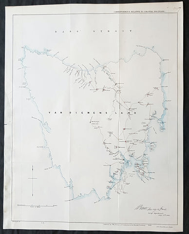
1846 Arrowsmith Rare Antique Convict Map of Van Diemens Land, Tasmania Australia
- Title : Van Diemens Land - Ordered by The House of Commons to be printed, February 1846
- Size: 21 1/2in x 17in (545mm x 430mm)
- Condition: (A+) Fine Condition
- Date : 1846
- Ref #: 82052
Description:
This large, rare & very important map of the convict settlements of Van Diemens Land in the mid 19th century by John Arrowsmith was engraved in 1846 - dated - and was published for The Colonial Office Parliamentary Papers, London. The map is highly detailed with all convict stations, towns and roads, including Port Arthur. An amazing Australian historical document.
The rarity of this map cannot be overstated. Many of these maps by Arrowsmith were printed and published only for the British Colonial Office Parliamentary Papers and would have numbered only in the 100s.
John Arrowsmith is considered one of the finest cartographers of the 19th century, famous for producing highly accurate and finely engraved maps in atlases, books & in sheet form, of all parts of the know world. Ironically he is less famous for producing many of the maps that accompanied the British Colonial Office Parliamentary Reports between 1817 to 1890, with two-thirds of the maps being produced by Arrowsmith. These maps were published solely for government review and not public sale. A few of these were subsequently published in Arrowsmiths Atlases and vice versa but a great number of them were not, making many of the maps published for the Parliamentary papers rare and rarely seen on the market. Many of them are not called for in Tooley, Clancy or other important reference material.
This is one of those maps, one of 27 we were fortunate to procure earlier this year. I have found very little historical sales data for these maps and so I have priced them based on what I feel is a fair market value for such a rare, scarce map.
Van Diemens Land & Convicts In 1803, a British expedition was sent from Sydney to Tasmania (then known as Van Diemen\'s Land) to establish a new penal colony there. The small party, led by Lt. John Bowen, established a settlement at Risdon Cove, on the eastern side of the Derwent River. Originally sent to Port Philip, but abandoned within weeks, another expedition led by Lieutenant-Colonel David Collins arrived soon after. Collins considered the Risdon Cove site inadequate, and in 1804 he established an alternative settlement on the western side of the river at Sullivan\'s Cove, Tasmania. This later became known as Hobart, and the original settlement at Risdon Cove was deserted. Collins became the first Lieutenant-Governor of Van Diemen\'s Land.
When the convict station on Norfolk Island was abandoned in 1807-1808, the remaining convicts and free settlers were transported to Hobart and allocated land for re-settlement. However, as the existing small population was already experiencing difficulties producing enough food, the sudden doubling of the population was almost catastrophic.
Starting in 1816, more free settlers began arriving from Great Britain. On 3 December 1825 Tasmania was declared a colony separate from New South Wales, with a separate administration.
The Macquarie Harbour penal colony on the West Coast of Tasmania was established in 1820 to exploit the valuable timber Huon Pine growing there for furniture making and shipbuilding. Macquarie Harbour had the added advantage of being almost impossible to escape from, most attempts ending with the convicts either drowning, dying of starvation in the bush, or (on at least two occasions) turning cannibal. Convicts sent to this settlement had usually re-offended during their sentence of transportation, and were treated very harshly, labouring in cold and wet weather, and subjected to severe corporal punishment for minor infractions.
In 1830, the Port Arthur penal settlement was established to replace Macquarie Harbour, as it was easier to maintain regular communications by sea. Although known in popular history as a particularly harsh prison, in reality its management was far more humane than Macquarie Harbour or the outlying stations of New South Wales. Experimentation with the so-called model prison system took place in Port Arthur. Solitary confinement was the preferred method of punishment.
Many changes were made to the manner in which convicts were handled in the general population, largely responsive to British public opinion on the harshness of their treatment. Until the late 1830s most convicts were either retained by Government for public works or assigned to private individuals as a form of indentured labour. From the early 1840s the Probation System was employed, where convicts spent an initial period, usually two years, in public works gangs on stations outside of the main settlements, then were freed to work for wages within a set district.
The continuation of transportation to Van Diemen\'s Land saw the rise of a well-coordinated anti-transportation movement, especially following a severe economic depression in the early 1840s. Transportation was temporarily suspended in 1846 but soon revived with overcrowding of British gaols and clamour for the availability of transportation as a deterrent. By the late 1840s most convicts being sent to Van Diemen\'s Land (plus those to Victoria) were designated as \"exiles\" and were free to work for pay while under sentence. In 1850 the Australasian Anti-Transportation League was formed to lobby for the permanent cessation of transportation, its aims being furthered by the commencement of the Australian gold rushes the following year. The last convict ship to be sent from England, the St. Vincent, arrived in 1853, and on 10 August Jubilee festivals in Hobart and Launceston celebrated 50 years of European settlement with the official end of transportation.
General Definitions:
Paper thickness and quality: - Heavy and stable
Paper color : - off white
Age of map color: - Original
Colors used: - Blue, pink, yellow
General color appearance: - Authentic
Paper size: - 22in x 17in (560mm x 430mm)
Plate size: - 22in x 17in (560mm x 430mm)
Margins: - Min 1/2in (12mm)
Imperfections:
Margins: - Bottom left margin extended from plate-mark
Plate area: - Folds as issued
Verso: - Bottom left margin extended from plate-mark
Background:
The importance of John Arrowsmiths contribution to early Australian cartography cannot be stressed enough. He was responsible for producing many of the early exploration maps of Australia for the Colonial Offices & Government publications as well as the RGS.
Maps produced after the first settlement and into the 19th century came from varied sources, first published with the First Fleet Journals by Arthur Phillip, John Hunter and Watkin Tench. Numerous European publishing houses produced atlases which included maps of Australia. Many came out in several editions and were updated as new information became available. The Australian Colonies were administered by officials responsible to the British Colonial Office and all events of importance, often illustrated by maps, were published in the British Parliamentary Papers. There a rea prime source of maps from 1830 onwards, although one or two maps may be found in Parliamentary Papers prior to this time, such as one example of a rare map of the Swan River by Captain James Stirling.
During the 19th century, as the Australian colonies were progressively granted responsible government, Parliamentary Papers for each colony became an important source of maps. These maps sources have been a hidden and untapped resource. Another good source of early maps is published journals of the explorers; the explorers earliest maps often accompanied reports in the
Journal of the Royal Geographical Society in the UK. Parallel development of Australian scientific institutions along with an interest in exploration was a strong feature of 19th century Australia. The Royal Geographical Society of Australasia was established with branches in NSW, Victoria, South Australia and Queensland. A number of important maps were published as separate sheets, increasingly by Australian printers and engravers such as Carmichael, Sands & Kenny, and Higginbotham, Robinson & Harrison.
Australian atlases were produced and repeat editions of cadastral surveys and maritime chats became increasingly available. Specialist maps were published from official sources, including geological and mineral maps. Towards the end of the century a plethora of thematic maps were published through a verity of media such as advertisements for land sales, tourists maps and street directories.
Parliamentary Papers British Parliamentary Papers were a funnel for all significant colonial events in the 19th century. They included over one hundred maps with information on topography, exploration and lad survey published between 1817 and 1890., with two-thirds of the maps being produced by John Arrowsmith. Few maps are found after the early 1860s. The maps accompanying papers relevant to gold discovery (1851-55) are a particularly good resource, documenting an important time in the history of Australia. Perhaps the most neglected source of early Australian maps are those included in the Colonial Parliamentary Papers published locally after 1836. The NSW Parliamentary Papers published between 1836 and 1900 contain over 2700 maps on 129 topics, providing a unique record of events considered important by the colonial administration. Land ownership and land use dominate, followed by maps of services relevant to land use, such as railways, roads, water supply and sewerage. Public health issues are recorded in maps as are maps of gold& mineral leases reflected the expanding diversity of the economy. The first map published in the NSW Parliamentary Papers, of the site of the new Government House, was lithographed by W.R. Baker in 1836. The total number of maps over the same period from other colonies was less than 2000 but again each colonies priorities were reflected by in the subjects covered. Tasmania reflected mainly geological and early convict disciplinary maps; South Australia, land administration and pastoral development; Victoria, maps relating to the development; Victoria, maps relating to the colonies infrastructure, especially railway and harbour development; Queensland, railway and mineral leases; Western Australia, a broad range that included two important technological innovations that shortened the time, and therefore the cost, of printing maps. Firstly , John Osborn in 1859, developed the use of a transfer paper method in photolithography which reduced printing time from days to hours. Secondly, Alfred Selwyn in 1860 used a steam-driven power press to print seven colour geological maps.
Royal Geographical Society published its first journal in 1832. This journal was to become the leading scientific medium available for explorers to publish the first news of their discoveries. However, not all explorers were published here. Between 1832 and 1880, 25 maps recorded of inland Australia, illustrating the journeys of 27 explorers. John Arrowsmith compiled 22 of the 25 maps published by the RGS again illustrating the importance of Arrowsmith to the expansion of early colonial cartography in Australia.
1854 John Arrowsmith Rare Antique Map, Early Town Plan of Gladstone, Queensland
- Title : Plan of the Town of Gladstone Port Curtis 1854 (Water is very scarce in this locality)
- Size: 22 1/4in x 16 3/4in (565mm x 425mm)
- Condition: (A+) Fine Condition
- Date : 1854
- Ref #: 82045
Description:
This large, rare & important map, a very early plan of the Queensland town of Gladstone by John Arrowsmith was engraved in 1854 - dated - and was published for The Colonial Office Parliamentary Papers, London.
The rarity of this map cannot be overstated. Many of these maps by Arrowsmith were printed and published only for the British Colonial Office Parliamentary Papers and would have numbered only in the 100s.
John Arrowsmith is considered one of the finest cartographers of the 19th century, famous for producing highly accurate and finely engraved maps in atlases, books & in sheet form, of all parts of the know world. Ironically he is less famous for producing many of the maps that accompanied the British Colonial Office Parliamentary Reports between 1817 to 1890, with two-thirds of the maps being produced by Arrowsmith. These maps were published solely for government review and not public sale. A few of these were subsequently published in Arrowsmiths Atlases and vice versa but a great number of them were not, making many of the maps published for the Parliamentary papers rare and rarely seen on the market. Many of them are not called for in Tooley, Clancy or other important reference material.
This is one of those maps, one of 27 we were fortunate to procure earlier this year. I have found very little historical sales data for these maps and so I have priced them based on what I feel is a fair market value for such a rare, scarce map.
Gladstone is a city in the Gladstone Region, Queensland, Australia. It is approximately 550 km (340 mi) by road north of Brisbane and 100 km south-east of Rockhampton. Situated between the Calliope and Boyne Rivers, Gladstone is home to Queensland\'s largest multi-commodity shipping port.
Before European settlement, the Gladstone region was home of the Toolooa (or Tulua), Meerooni and Baiali (or Byellee) Aboriginal tribes.
In May 1770, the HM Bark Endeavour, under the command of James Cook, sailed by the entrance to Gladstone Harbour under the cover of darkness. Matthew Flinders, during his 1801–1803 circumnavigation of Australia, became the first recorded European to sight the harbour in August 1802. He named the harbour Port Curtis, after Admiral Roger Curtis, a man who was of assistance to Flinders a year earlier at the Cape of Good Hope. John Oxley conducted further exploration of the harbour and surrounding countryside in November 1823. Oxley was dismissive of the region, noting the harbour was difficult to enter, the countryside was too dry, and the timber useless for construction purposes.
Nevertheless, in 1847 the British attempted to establish the new colony of North Australia at Port Curtis. Colonel George Barney was chosen to lead this experiment in colonisation and his expedition was eventful. On 25 January 1847, the Lord Auckland, carrying 87 soldiers and convicts, arrived off the southern entrance of Port Curtis and promptly ran aground on shoals off the southern tip of Facing Island. The settlers spent seven weeks on the island before being rescued by the supply ship Thomas Lowry and delivered the intended site of settlement, the region now known as Barney Point. On 30 January at a proclamation ceremony, Barney was sworn in as Lieutenant Governor of the colony of North Australia. The convict settlement lasted barely two months and cost the Imperial government ₤15,000. A change of government in Britain ordered the withdrawal of Barney and the settlers. However, interest in the region remained.
By 1853, Francis MacCabe was surveying the site of a new town on the shores of Port Curtis under the protection of several detachments of Native Police. Maurice O\'Connell was appointed government resident the following year, resulting in an influx of free settlers as land became available throughout the region. In 1863, the town became a Municipality with Richard Hetherington elected Gladstones first mayor. The fledgling town was named after the British Prime Minister William Ewart Gladstone and has a 19th-century marble statue on display in its town museum.
General Definitions:
Paper thickness and quality: - Heavy and stable
Paper color : - off white
Age of map color: - Original
Colors used: - Blue, pink, green
General color appearance: - Authentic
Paper size: - 22 1/4in x 16 3/4in (565mm x 425mm)
Plate size: - 22 1/4in x 16 3/4in (565mm x 425mm)
Margins: - Min 1/2in (12mm)
Imperfections:
Margins: - None
Plate area: - Folds as issued
Verso: - None
Background:
The importance of John Arrowsmiths contribution to early Australian cartography cannot be stressed enough. He was responsible for producing many of the early exploration maps of Australia for the Colonial Offices & Government publications as well as the RGS.
Maps produced after the first settlement and into the 19th century came from varied sources, first published with the First Fleet Journals by Arthur Phillip, John Hunter and Watkin Tench. Numerous European publishing houses produced atlases which included maps of Australia. Many came out in several editions and were updated as new information became available. The Australian Colonies were administered by officials responsible to the British Colonial Office and all events of importance, often illustrated by maps, were published in the British Parliamentary Papers. There a rea prime source of maps from 1830 onwards, although one or two maps may be found in Parliamentary Papers prior to this time, such as one example of a rare map of the Swan River by Captain James Stirling.
During the 19th century, as the Australian colonies were progressively granted responsible government, Parliamentary Papers for each colony became an important source of maps. These maps sources have been a hidden and untapped resource. Another good source of early maps is published journals of the explorers; the explorers earliest maps often accompanied reports in the
Journal of the Royal Geographical Society in the UK. Parallel development of Australian scientific institutions along with an interest in exploration was a strong feature of 19th century Australia. The Royal Geographical Society of Australasia was established with branches in NSW, Victoria, South Australia and Queensland. A number of important maps were published as separate sheets, increasingly by Australian printers and engravers such as Carmichael, Sands & Kenny, and Higginbotham, Robinson & Harrison.
Australian atlases were produced and repeat editions of cadastral surveys and maritime chats became increasingly available. Specialist maps were published from official sources, including geological and mineral maps. Towards the end of the century a plethora of thematic maps were published through a verity of media such as advertisements for land sales, tourists maps and street directories.
Parliamentary Papers British Parliamentary Papers were a funnel for all significant colonial events in the 19th century. They included over one hundred maps with information on topography, exploration and lad survey published between 1817 and 1890., with two-thirds of the maps being produced by John Arrowsmith. Few maps are found after the early 1860s. The maps accompanying papers relevant to gold discovery (1851-55) are a particularly good resource, documenting an important time in the history of Australia. Perhaps the most neglected source of early Australian maps are those included in the Colonial Parliamentary Papers published locally after 1836. The NSW Parliamentary Papers published between 1836 and 1900 contain over 2700 maps on 129 topics, providing a unique record of events considered important by the colonial administration. Land ownership and land use dominate, followed by maps of services relevant to land use, such as railways, roads, water supply and sewerage. Public health issues are recorded in maps as are maps of gold& mineral leases reflected the expanding diversity of the economy. The first map published in the NSW Parliamentary Papers, of the site of the new Government House, was lithographed by W.R. Baker in 1836. The total number of maps over the same period from other colonies was less than 2000 but again each colonies priorities were reflected by in the subjects covered. Tasmania reflected mainly geological and early convict disciplinary maps; South Australia, land administration and pastoral development; Victoria, maps relating to the development; Victoria, maps relating to the colonies infrastructure, especially railway and harbour development; Queensland, railway and mineral leases; Western Australia, a broad range that included two important technological innovations that shortened the time, and therefore the cost, of printing maps. Firstly , John Osborn in 1859, developed the use of a transfer paper method in photolithography which reduced printing time from days to hours. Secondly, Alfred Selwyn in 1860 used a steam-driven power press to print seven colour geological maps.
Royal Geographical Society published its first journal in 1832. This journal was to become the leading scientific medium available for explorers to publish the first news of their discoveries. However, not all explorers were published here. Between 1832 and 1880, 25 maps recorded of inland Australia, illustrating the journeys of 27 explorers. John Arrowsmith compiled 22 of the 25 maps published by the RGS again illustrating the importance of Arrowsmith to the expansion of early colonial cartography in Australia.
1817 John Thomson Large Antique Map of North & South America, Hawaiian Islands
- Title : America...Drawn & Engraved for Thomsons New General Atlas
- Date : 1817
- Size: 28in x 21 1/2in (710mm x 550mm)
- Condition: (A+) Fine Condition
- Ref: 35020
Description:
This large magnificent original hand coloured copper-plate engraved antique map of America drawn & engraved by John Thomson was published in the 1817 edition of Thomsons General Atlas
General Definitions:
Paper thickness and quality: - Heavy and stable
Paper color : - off white
Age of map color: - Original
Colors used: - Yellow, green, blue, pink
General color appearance: - Authentic
Paper size: - 28in x 21 1/2in (710mm x 550mm)
Plate size: - 25in x 20in (635mm x 510mm)
Margins: - Min 1in (25mm)
Imperfections:
Margins: - None
Plate area: - None
Verso: - None
Background:
The exploration of North America by non-indigenous people was a continuing effort to map and explore the continent of North America. It spanned centuries, and consisted of efforts by numerous people and expeditions from various foreign countries to map the continent. The European colonization of the Americas followed.
There were numerous Spanish explorers and conquistadors who explored the Southwest of North America (including present-day west and central United States) and cross the continent (east to west) in its southern regions, mainly from the second quarter to the middle of the 16th century, such as Álvar Núñez Cabeza de Vaca and Francisco Vásquez de Coronado, but also the North American Southeast and south-central regions, s Soto]].
In 1608 Samuel de Champlain founded what is now Quebec City, which would become the first permanent settlement and the capital of New France. He took personal administration over the city and its affairs, and sent out expeditions to explore the interior. Champlain himself discovered Lake Champlain in 1609. By 1615, he had travelled by canoe up the Ottawa River through Lake Nipissing and Georgian Bay to the centre of Huron country near Lake Simcoe. During these voyages, Champlain aided the Wendat (aka Hurons) in their battles against the Iroquois Confederacy. As a result, the Iroquois would become enemies of the French and be involved in multiple conflicts.
From 1679 to 1682 René-Robert Cavelier, Sieur de La Salle explored the Great Lakes region of the United States and Canada, and the entire course of Mississippi River to the Gulf of Mexico.
From 1697 to 1702 Eusebio Kino explored the Sonoran Desert and on his journey to the Colorado River Delta discovered an overland route to Baja California that was then commonly believed to be an island. In 1683 Kino lead the first European overland crossing of Baja California.
European exploration of western Canada was largely motivated by the fur trade and the search for the elusive Northwest Passage. Hudson\'s Bay Company explorer Henry Kelsey has the distinction of being the first European to see the northern Great Plains in 1690.
Anthony Henday was the first to have seen the Rocky Mountains, in 1754, but curiously did not mention it in his journals. From his westernmost geographic position (roughly near the town of Olds, Alberta, halfway between Calgary and Red Deer, Alberta) the Rockies should have been quite conspicuous, but he was likely trying to disguise the disappointing fact that an unknown range of seemingly impassible mountains now stood between the HBC and the Pacific. Samuel Hearne found the Coppermine River in 1769-71 in his failed search for copper ore deposits. Burned by these shortfalls, the HBC largely quit exploration.
The North West Company, on the other hand, used a business model that required constant expansion into untapped areas. Under the auspices of the NWC, Alexander Mackenzie discovered the Mackenzie River in 1789 and was the first European to reach the North-American Pacific overland, via the Bella Coola River, in 1793. Simon Fraser reached the Pacific in 1808 via the Fraser River.
David Thompson, widely regarded as the greatest land geographer that ever lived, traveled over 90,000 km during his lifetime. In 1797, Thompson was sent south by his employers to survey part of the Canada-U.S. boundary along the water routes from Lake Superior to Lake of the Woods to satisfy unresolved questions of territory arising from the Jay Treaty between Great Britain and the United States. By 1798 Thompson had completed a survey of 6,750 km (4,190 mi) from Grand Portage, through Lake Winnipeg, to the headwaters of the Assiniboine and Mississippi Rivers, as well as two sides of Lake Superior. In 1798, the company sent him to Red Deer Lake (in present-day Alberta) to establish a trading post. The English translation of Lac La Biche-Red Deer Lake-first appeared on the Mackenzie map of 1793. Thompson spent the next few seasons trading based in Fort George (now in Alberta), and during this time led several expeditions into the Rocky Mountains. In 1811/1812 he followed the Columbia River to the Pacific, and in 1814 used his notes and measurements to draft the first European-style map of western Canada, covering 3.9 million square kilometres.
Lewis and Clark were the first Americans to venture into the newly acquired territory of the Louisiana Purchase, at the order of President Thomas Jefferson. They discovered many new geographical features, Indian tribes, and animal and plant species. John Colter was a member of the expedition who subsequently became a guide for others in the Old West, and did some explorations of his own.
John C. Frémont led many important explorations in the Great Plains, Great Basin, Oregon territory, and Mexican Alta California.
Joseph Reddeford Walker was one of the most prominent of the explorers, and charted many new paths through the West, which often were then utilized by emigrants crossing to settle in Western towns and communities. In 1833, his exploring party discovered a route along the Humboldt River across present-day Nevada, ascending the Sierra Nevada following the Carson River and descending via Stanislaus River drainages to Monterey. His return route across the southern Sierra was via Walker Pass, named after Walker by John Charles Fremont. The approach of the Sierra via the Carson River route later became known as the California Trail, the primary route for the emigrants to the gold fields during the California gold rush.
As the American population of the West increased, the US government launched ongoing official explorations mainly through the US Army Corps of Topographical Engineers. One of the main officers and explorers in this unit was George Wheeler. In 1872, the US Congress authorized an ambitious plan to map the portion of the United States west of the 100th meridian at a scale of 8 miles to the inch. This plan necessitated what became known as the Wheeler Survey, along with the Clarence King and John Wesley Powell Surveys, and expeditions by Ferdinand Vandeveer Hayden. In 1879, all such efforts were reorganized as the United States Geological Survey.
1755 D Anville & Bolton Large Antique Map of Asia, Turkey, Saudi Arabia, India
- Title : First Part of Asia being Turkey, Arabia, Persia most of India and Tartary Performed by the Sr D Anville...Revised and Improved by Mr Bolton MDCCLV (1755)
- Size: 31 1/2in x 30in (800mm x 765mm)
- Condition: (A) Very Good Condition
- Date : 1755
- Ref #: 91298
Description:
This large original hand coloured, copper plate engraved antique map of western Asia from Turkey to Saudi Arabia to India by Solomon Bolton, after the French cartographer Jean Baptiste Bourguignon D Anville, was engraved in 1755 - dated - and published in the 1765 edition of Malachy Postlethweyts monumental 2 Volume tomes on The Universal Dictionary of Trade & Commerce concentrating on various states of trade, including slavery, between England and America published between 1751 & 1774.
General Definitions:
Paper thickness and quality: - Heavy and stable
Paper color : - off white
Age of map color: - Early
Colors used: - Yellow, green, blue, pink
General color appearance: - Authentic
Paper size: - 31 1/2in x 30in (800mm x 765mm)
Plate size: - 31 1/2in x 30in (800mm x 765mm)
Margins: - Min 1/2in (10mm)
Imperfections:
Margins: - Top margin extended from plate mark
Plate area: - Folds as issued, small restoration to left fold
Verso: - Folds as issued
Background:
Postlethweyt, Malachy 1707 – 1767
Malachy Postlethweyts Dictionary of Trade & Commerce: A monumental dictionary of trade and commerce. It is based in part on the Dictionnaire universel de Commerce (Paris: 1723-30) of Jacques Savary de Bruslon, under whose name it is often catalogued, but has been adapted by Postlethwayt for a British audience, with substantial enlargements and improvements, and entirely new material relating to England and her colonies. Postlethwayt devoted twenty years to the preparation of the dictionary, which was first published in 1751-55 & includes a description of British affairs in North America since the peace of 1763.
As with his other works, the dictionary demonstrates Postlethway’s deep commitment to the expansion and strengthening of English trade. Included are entries for geographical locations (Africa, Antilles, Canada, Japan, Louisiana, &c.), products (brandy, cardamom, codfish, diamonds, sugar, &c.), trading companies (Dutch East India Company, English African Company, &c.), treaties of commerce, and a vast range of other information of value to merchants (bankruptcy, currency, bills of exchange, brokerage, exportation, landed interest, privateering, &c.). The Dictionary is also important for containing almost the whole substance of Richard Cantillon’s Essay on Commerce, its first appearance in print.
1782 Robert Sayer & John Bennett Large Early Antique Map of London, Rare
- Title : The London Directory or a New & Improved Plan of London, Westminster & Southwark; with the adjacent Country, the New Buildings, the New Roads and the late alterations by Opening of New Streets, & Widening of others 1782.
- Size: 20 1/2in x 16in (510mm x 410mm)
- Condition: (A) Very Good Condition
- Date : 1782
- Ref #: 93047
Description:
This original copper-plate engraved antique segmented map laid on linen of London was engraved in 1782 - dated - and published by Robert Sayer and John Bennett, London.
General Definitions:
Paper thickness and quality: - Heavy and stable
Paper color : - off white
Age of map color: - Original
Colors used: - Green, brown
General color appearance: - Authentic
Paper size: - 20 1/2in x 16in (510mm x 410mm)
Plate size: - 20 1/2in x 16in (510mm x 410mm)
Margins: - Min 1/2in (12mm)
Imperfections:
Margins: - Age toning
Plate area: - Age toned
Verso: - Linen backed
Background:
A highly appealing 1783 map centered on the Thames River. The map details central London from Islington to Shadwell and from Newington Butts to Tyburn. Only three bridges are shown, across the Thames: Westminster Bridge, London Bridge, and Blackfriars (B.L. Fryers). The portions of the city devastated by the 1666 Great Fire of London is marked. A street index and public building index appears below the map proper. The earliest edition of this map was published by Sayer in 1765, with numerous updates to about 1800 – all states are rare, this being the 7th of 1783. Another, almost identical version of this map was issued by John Carrington and, having a slightly longer lifespan, was published and updated until about 1811.
Sayer, Robert 1725 - 1794
Sayer was an important English map publisher and engraver active from the mid to late 18th century. Sayer was born in Sunderland, England, in 1725. He may have clerked as a young man with the Bank of England, but this is unclear. His brother, James Sayer, married Mary Overton, daughter-in-law of John Overton and widow of Philip Overton. Sayer initially worked under Mary Overton, but by December of 1748 was managing the Overton enterprise and gradually took it over, transitioning the plates to his own name. When Thomas Jefferys went bankrupt in 1766, Sayer offered financial assistance to help him stay in business and, in this way, acquired rights to many of the important Jefferys map plates as well as his unpublished research. From about 1774, he began publishing with his apprentice, John Bennett (fl. 1770-1784), as Sayer and Bennett, but the partnership was not formalized until 1777. Bennett retired in 1784 following a mental collapse and the imprint reverted to Robert Sayer. From 1790, Sayer added Robert Laurie and James Whittle to his enterprise, renaming the firm Robert Sayer and Company. Ultimately, Laurie and Whittle partnered to take over his firm. Sayer retired to Bath, where, after a long illness, he died. During most of his career, Sayer was based at 53 Fleet Street, London. His work is particularly significant for its publication of many British maps relating to the American Revolutionary War. Unlike many map makers of his generation, Sayer was a good businessman and left a personal fortune and great estate to his son, James Sayer, who never worked in the publishing business.
1857 A D Bache Large Rare Antique Map of San Diego Bay, California
- Title : San Diego Bay California From a Trigonomitrical Survey under the Direction of A D Buache Superintendant of the Survey of the Coast of the United States...1857
- Size: 29in x 22in (740mm x 560mm)
- Condition: (A+) Fine Condition
- Date : 1857
- Ref #: 93033
Description:
This large rare, original lithograph early antique map of San Diego Bay, California by Alexander Dallas Bache (great-grandson of Benjamin Franklin) in 1857 - dated - was published by the official chart-maker of the United States, the office of The US Coast Survey.
The Office of the Coast Survey, founded in 1807 by President Thomas Jefferson and Secretary of Commerce Albert Gallatin, is the oldest scientific organization in the U.S. Federal Government. Jefferson created the Survey of the Coast, as it was then called, in response to a need for accurate navigational charts of the new nation\'s coasts and harbors.
Background:
This is the most attractive map of San Diego Bay, California, to emerge from the work of the U.S. Coast Survey. Covers the Sand Diego area from False Bay and the Valley of Las Yeguas southward past Mission Valley and San Diego city to San Diego Bay and the villages of La Punta and the Valley of Ohjia. Offers superb detail both inland and at sea. Inland detail includes topographical features, rivers, roads, and villages. Villages and cities, including San Diego, La Playa, New San Diego, and others, are detailed to the level of individual buildings. Nautical details include innumerable depth sounding, breakwaters, and notes on the Kelp Beds off the coast of Point Lonia. Lower left quadrant features textual sailing instructions as well as notes on the tides and a history of the chart.
General Definitions:
Paper thickness and quality: - Heavy and stable
Paper color : - off white
Age of map color: -
Colors used: -
General color appearance: -
Paper size: - 29in x 22in (740mm x 560mm)
Plate size: - 29in x 22in (740mm x 560mm)
Margins: - Min 1/2in (12mm)
Imperfections:
Margins: - None
Plate area: - Folds as issued, light age toning
Verso: - Some folds re-enforced with archival tape
U.S. Coast Survey (Office of Coast Survey)
The Office of Coast Survey is the official chart-maker of the United States. Set up in 1807, it is one of the U.S. governments oldest scientific organizations. In 1878 it was given the name of Coast and Geodetic Survey (C&GS). In 1970 it became part of the National Oceanic and Atmospheric Administration (NOAA).
The agency was established in 1807 when President Thomas Jefferson signed the document entitled An act to provide for surveying the coasts of the United States. While the bills objective was specific—to produce nautical charts—it reflected larger issues of concern to the new nation: national boundaries, commerce, and defence.
The early years were difficult. Ferdinand Rudolph Hassler, who was eventually to become the agencys first superintendent, went to England to collect scientific instruments but was unable to return through the duration of the War of 1812. After his return, he worked on a survey of the New York Harbor in 1817, but Congress stepped in to suspend the work because of tensions between civilian and military control of the agency. After several years under the control of the U.S. Army, the Survey of the Coast was reestablished in 1832, and President Andrew Jackson appointed Hassler as superintendent.
The U.S. Coast Survey was a civilian agency but, from the beginning, members of the Navy and Army were detailed to service with the Survey, and Navy ships were also detailed to its use. In general, army officers worked on topographic surveys on the land and maps based on the surveys, while navy officers worked on hydrographic surveys in coastal waters.
Alexander Dallas Bache, great-grandson of Benjamin Franklin, was the second Coast Survey superintendent. Bache was a physicist, scientist, and surveyor who established the first magnetic observatory and served as the first president of the National Academy of Sciences. Under Bache, Coast Survey quickly applied its resources to the Union cause during the Civil War. In addition to setting up additional lithographic presses to produce the thousands of charts required by the Navy and other vessels, Bache made a critical decision to send Coast Survey parties to work with blockading squadrons and armies in the field, producing hundreds of maps and charts. Bache detailed these activities in his annual reports to Congress.
Coast Survey cartographer Edwin Hergesheimer created the map showing the density of the slave population in the Southern states.
Bache was also one of four members of the governments Blockade Strategy Board, planning strategy to essentially strangle the South, economically and militarily. On April 16, 1861, President Lincoln issued a proclamation declaring the blockade of ports from South Carolina to Texas. Baches Notes on the Coast provided valuable information for Union naval forces.
Maps were of paramount importance in wartime:
It is certain that accurate maps must form the basis of well-conducted military operations, and that the best time to procure them is not when an attack is impending, or when the army waits, but when there is no hindrance to, or pressure upon, the surveyors. That no coast can be effectively attacked, defended, or blockaded without accurate maps and charts, has been fully proved by the events of the last two years, if, indeed, such a proposition required practical proof.
— Alexander Dallas Bache, 1862 report.
Coast Survey attracted some of the best and brightest scientists and naturalists. It commissioned the naturalist Louis Agassiz to conduct the first scientific study of the Florida reef system. James McNeill Whistler, who went on to paint the iconic Whistlers Mother, was a Coast Survey engraver. The naturalist John Muir was a guide and artist on Survey of the 39th Parallel across the Great Basin of Nevada and Utah.
The agencys men and women (women professionals were hired as early as 1845) led scientific and engineering activities through the decades. In 1926, they started production of aeronautical charts. During the height of the Great Depression, Coast and Geodetic Survey organized surveying parties and field offices that employed over 10,000 people, including many out-of-work engineers.
In World War II, C&GS sent over 1,000 civilian members and more than half of its commissioned officers to serve as hydrographers, artillery surveyors, cartographers, army engineers, intelligence officers, and geophysicists in all theaters of the war. Civilians on the home front produced over 100 million maps and charts for the Allied Forces. Eleven members of the C&GS gave their lives during the war.
Alexander Dallas Bache 1806 – 1867 was an American physicist, scientist, and surveyor who erected coastal fortifications and conducted a detailed survey to map the mid-eastern United States coastline. Originally an army engineer, he later became Superintendent of the U.S. Coast Survey, and built it into the foremost scientific institution in the country before the Civil War.
Alexander Bache was born in Philadelphia, the son of Richard Bache, Jr., and Sophia Burrell Dallas Bache. He came from a prominent family as he was the nephew of Vice-President George M. Dallas and naval hero Alexander J. Dallas. He was the grandson of Secretary of the Treasury Alexander Dallas and was the great-grandson of Benjamin Franklin.
Bache was a professor of natural philosophy and chemistry at the University of Pennsylvania from 1828 to 1841 and again from 1842 to 1843. He spent 1836–1838 in Europe on behalf of the trustees of what became Girard College; he was named president of the college after his return. Abroad, he examined European education systems, and on his return he published a valuable report. From 1839 to 1842, he served as the first president of Central High School of Philadelphia, one of the oldest public high schools in the United States.
In 1843, on the death of Professor Ferdinand Rudolph Hassler, Bache was appointed superintendent of the United States Coast Survey. He convinced the United States Congress of the value of this work and, by means of the liberal aid it granted, he completed the mapping of the whole coast by a skillful division of labor and the erection of numerous observing stations. In addition, magnetic and meteorological data were collected. Bache served as head of the Coast Survey for 24 years (until his death).
1778 Antonio Zatta & John Mitchell Antique Map of Lake Superior & Florida
- Title : Il Paese de Selvaggi Outauace si e Kilistinesi Intorno Al Lago Superiore; Supplemento alla Florida Orientale
- Date : 1778
- Condition: (A+) Fine Condition
- Ref: 93517
- Size: 21in x 15 1/2in (535mm x 395mm)
Description:
This wonderfully executed original copper plate engraved hand coloured antique map of Lake Superior, with an inset map of southern Florida, was published as Sheet 1, of 12, of Antonio Zattas 1778 re-issue of John Mitchells famous landmark map A Map of the British and French Dominions in North America, With the Roads, Distances, Limits, and Extent of the Settlements was published in Zattas Atlas Atlante Novissimo (1779-1785)
I have included an image of the complete 12 sheet joined map by Zatta as well as an image of Mitchells map.
General Definitions:
Paper thickness and quality: - Heavy and stable
Paper color : - off white
Age of map color: - Original
Colors used: - Yellow, green, blue, pink
General color appearance: - Authentic
Paper size: - 21in x 15 1/2in (535mm x 395mm)
Plate size: - 17 1/2in x 13 1/2in (445mm x 345mm)
Margins: - Min 1in (25mm)
Imperfections:
Margins: - None
Plate area: - None
Verso: - None
Background:
The Mitchell Map by John Mitchell (1711–1768) is considered the most famous map of North America both cartographically and historically, was reprinted several times during the second half of the 18th century. The Mitchell Map was used as a primary map source during the Treaty of Paris for defining the boundaries of the newly independent United States. The map remained important for resolving border disputes between the United States and Canada as recently as the 1980s dispute over the Gulf of Maine fisheries. The Mitchell Map is the most comprehensive map of eastern North America made during the colonial era. Its size is about 6.5 feet (2.0 m) wide by 4.5 feet (1.4 m) high.
John Mitchell was not a professional geographer or map-maker. Son of a wealthy Virginian family in Lancaster County, on Virginia's Northern Neck, he had been educated at Edinburgh University, Scotland; this education included the first two years of the three-year medical program. Returning to coastal Virginia, he practiced as a physician and studied the local botany. Ill health forced Mitchell and his wife to leave Virginia for London in 1746. There, he served as a consultant on exotic plants to noblemen interested in gardens. Also, it was there that Mitchell would make his famous map. Map historians have understandably been interested in why a physician and botanist who had shown no previous interest in map making should make such a large and detailed map.
Until recently, historians have argued that Mitchell was upset by the lack of interest shown by politicians in London about colonial affairs and so set out to warn them about the dangers posed to the British colonies by the French. Mitchell did so, on his own initiative, by making a first map of North America in 1750, which he then showed to the politicians he knew through his botanical and gardening activities. The map so impressed George Montagu-Dunk, 2nd Earl of Halifax, appointed president of the Board of Trade and Plantations in 1748, that Halifax opened up the official archives and solicited new maps from the colonies for Mitchell to make a new and better map. This was the map published in 1755. That is, the motive force for preparations against the French threat is understood to have come from a colonist who sought to take control of the colonies' future on behalf of the other colonists.
A re-examination of the archival evidence indicates, however, that Mitchell made his first map in 1750 at Halifax's behest. Halifax became president of the Board of Trade directly after the conclusion of the War of the Austrian Succession (1744–1748) and its North American component, King George's War. The war had ended in stalemate and a return to the Anglo-French status quo of the 1714 Treaty of Utrecht. In fact, it was a common conviction that it was only a matter of time before another global Anglo-French war would begin, and it was commonly expected that the spark of the new conflict would be the North American colonies. It was then that Halifax latched onto Mitchell as an expert informant on all things colonial; one of his requests, apparently, was for Mitchell to make a new map to show the territorial situation in North America. Certainly, it was only after 1749 that Mitchell's correspondence revealed his new interests in both geography and politics.
Mitchell compiled a first map in 1750 from the materials that he could find in London, in official archives and private hands. It proved to be inadequate. Halifax accordingly ordered the governors of the British colonies to send new maps, which most did. These became the basis, when fitted into the overall geographical frame provided by the maps of the French geographer Guillaume Delisle. Late in 1754, Halifax was using one manuscript copy of Mitchell's second map to successfully promote his political position (no compromise with the French) within the British cabinet in the build-up to the Seven Years' War aka French and Indian War. Halifax also permitted Mitchell to have the map published: it appeared in April 1755, engraved by Thomas Kitchin and published by Andrew Millar.
The published map bore the title A Map of the British and French Dominions in North America. It bore the copyright date of 13 February 1755, but the map was probably not sold to the public until April or even May. Minor corrections to the map's printing plates were made probably during the printing process.
The geographer John Green (né Braddock Mead) criticized Mitchell and his map soon after it appeared, emphasizing two failings with respect to Nova Scotia (an area of particular dispute with the French). Mitchell, Green noted, had used neither the astronomical observations for latitude and longitude made by Marquis Joseph Bernard de Chabert in the 1740s nor a 1715 chart of the Nova Scotia coast. In response, Mitchell released a new version of his map, now with two large blocks of text that described all of his data sources; the new version of the map also adjusted the coastline in line with Chabert's work but rejected the 1715 chart as deeply flawed. This version of the map, which Mitchell referred to as the "second edition," is commonly thought to have appeared sometime in 1757, but advertisements in the (London) Public Advertiser and Gazetteer and London Daily Advertiser on 23 April 1756 clearly indicate that this new map appeared at that time.
The map continued to be corrected and some boundaries updated, even after Mitchell's death in 1768.
Mitchell's map was printed in eight sheets; when assembled, it measures 136 cm by 195 cm (4 feet 6 inches by 6 feet 5 inches; height x width). The initial impressions printed in 1755 have a consistent coloring outlining British colonial claims. Mitchell extended the southern colonies across the entire continent, even over established Spanish territory west of the Mississippi. Mitchell divided up the Iroquois territories (as he understood them, reaching from Lake Champlain [Lac Irocoisia] to the Mississippi, and north of Lake Superior) between Virginia and New York, leaving only a much-reduced territory to the French.
Mitchell's map was expensive but it spawned many cheaper variants that trumpeted Halifax and Mitchell's powerful colonial vision to the British public. One of these, published in December 1755 by "a Society of Anti-Gallicans", restricted the French even further just to Quebec.
The map is liberally sprinkled with text describing and explaining various features, especially in regions that were relatively unknown or which were subject to political dispute. Many notes describe the natural resources and potential for settlement of frontier regions. Others describe Indian tribes. Many Indian settlements are shown, along with important Indian trails.
Since Mitchell's main objective was to show the French threat to the British colonies, there is a very strong pro-British bias in the map, especially with regard to the Iroquois. The map makes clear that the Iroquois were not just allies of Britain, but subjects, and that all Iroquois land was therefore British territory. Huge parts of the continent are noted as being British due to Iroquois conquest of one tribe or another. French activity within the Iroquois claimed lands is noted, explicitly or implicitly, as illegal.
In cases where the imperial claims of Britain and France were questionable, Mitchell always takes the British side. Thus many of his notes and boundaries seem like political propaganda today. Some of the claims seem to be outright falsehoods.
The map is very large and the notes are often very small, making it difficult to view online. Reduced scale copies result in unreadable notes. The following list gives a few examples of the kind of notes found on the map, with Mitchell's spelling:
- The region of today's central Tennessee and Kentucky (between the Tennessee and Cumberland Rivers): A Fine Level Fertile Country of great Extent, by Accounts of the Indians and our People
- In the area between the Mississippi River and the Tennessee River: This Country of the Cherokees which extends Westward to the Mississippi and Northward to the Confines of the Six Nations was formally surrendered to the Crown of Britain at Westminster 1729
- In the Great Plains: The Nadouessoians are reckoned one of the most Populous Nations of Indians in North America, altho' the number and situation of their Villages are not known nor laid down. (Reference to the Sioux)
- Along the coast of the Gulf of Mexico, present-day Texas: Wandering Savage Indians
- Southwest of Hudson Bay: The long and Barbarous Names lately given to some of these Northern Parts of Canada and the Lakes we have not inserted, as they are of no use, and uncertain Authority.
- North of Lake Huron: MESSESAGUES—Subdued by the Iroquois and now united with them making the 8th Nation in that League. (reference to the Mississaugas)
- Missouri River: Missouri River is reckoned to run Westward to the Mountains of New Mexico, as far as the Ohio does Eastward
- Present-day Iowa: Extensive Meadows full of Buffaloes
- Sandusky, Ohio: Sandoski—Canahogue—The seat of War, the Mart of Trade, & chief Hunting Grounds of the Six Nations, on the Lakes & the Ohio.
- Central Pennsylvania, north of present-day Harrisburg: St. Anthony's Wilderness
- Illinois region: The Antient Eriez were extirpated by the Iroquois upwards of 100 years ago, ever since which time they have been in Possession of L. Erie (reference to the Erie people)
- Along Illinois River and overland to the south end of Lake Michigan: Western Bounds of the Six Nations sold and Surrendered to Great Britain
- Illinois region: The Six Nations have extended their Territories to the River Illinois, ever since the Year 1672, when they subdued, and were incorporated with, the Antient Chaouanons, the Native Proprietors of these Countries, and the River Ohio. Besides which they likewise claim a Right of Conquest over the Illinois, and all the Mississippi as far as they extend. This is confirmed by their own Claims and Possessions in 1742, which include all the Bounds here laid down, and none have ever thought fit to dispute them. (reference to the Illiniwek)
- Just below the previous note: The Ohio Indians are a mixt Tribe of the Several Indians of our Colonies, settled here under the Six Nations, who have always been in Alliance and Subjection to the English. The most numerous of them are the Delaware and Shawnoes, who are Natives of Delaware River. Those about Philadelphia were called Sauwanoos whom we now call Shawanoes, or Shawnoes. The Mohickans and Minquaas were the Antient Inhabitants of Susquehanna R. (reference to the Lenape, Shawnee, and Susquehannock Indians)
- Southeast Missouri area: Mines of Marameg, which gave rise to the famous Mississippi Scheme 1719.
- North Florida: TIMOOQUA—Destroy'd by the Carolinians in 1706 (reference to the Timucua)
- South Georgia: COUNTRY OF THE APALACHEES—Conquered & surrendered to the Carolinians, after two memorable Victories obtain'd over them & the Spaniards in 1702 & 1703 at the Places marked thus [crossed-swords] (reference to the Apalachee)
- Alabama area: The English have Factories & Settlements in all the Towns of the Creek Indians of any note, except Albamas; which was usurped by the French in 1715 but established by the English 28 years before. (reference to the Creek people)
- Yazoo River: River of the Yasous—The Indians on this River were in Alliance with the English, for which they have been destroyed by the French (reference to the Yazoo tribe)
- Many geographic features are labeled with names no longer in use or oddly spelled, including:
Des Moines River: Moingona River
Kanawha and New River together: Gr. Conhaway called Wood R. or New R.
Kentucky River: Cuttawa or Catawba R.
Clinch River: Pelisipi River (a tributary is labeled Clinch's R.)
Tennessee River: River of the Cherakees, or Hogohegee R. Upstream another label says River Hogohegee or Callamaco
French Broad River: Agiqua R.
Little Tennessee River: Tannaſsee or Satico R.
Hiwassee River: Euphasee
Ohio River: Ohio or Splawacipiki R.
Altamaha River: Alatamaha or George R.
Minnesota River: Ouadebameniſsouté or R. St. Peter (reflecting the Dakota name Watpá Mnísota and the French name Rivière de St. Pierre)
Muskegon River: Maticon R.
The map also included non-existent features, such as Isle Phelipeaux in Lake Superior, found in earlier maps by Jacques-Nicolas Bellin.
The Mitchell Map remained the most detailed map of North America available in the later eighteenth century. Various impressions (and also French copies) were used to establish the boundaries of the new United States of America by diplomats at the 1783 Treaty of Paris that ended the American Revolutionary War. The map's inaccuracies subsequently led to a number of border disputes, such as in Maine. Its supposition that the Mississippi River extended north to the 50th parallel (into British territory) resulted in the treaty using it as a landmark for a geographically impossible definition of the border in that region. It was not until 1842, when the Webster-Ashburton Treaty resolved these inconsistencies with fixes such as the one that created Minnesota's Northwest Angle, that the U.S.–Canada border was clearly drawn from Maine to the Oregon Country.
Similarly, during the drafting of the Northwest Ordinance, the map's inaccuracy in depicting where an east–west line drawn through the southernmost point of Lake Michigan would intersect Lake Erie led to a long dispute over the Ohio–Michigan border that culminated in the Toledo War.
1730 Matthaus Seutter Large Antique Map of Norway
- Title : Regnum Norwegiae...Matthaei Seutteri
- Ref #: 17020
- Size: 24 1/2in x 21in (630mm x 530mm)
- Date : 1730
- Condition: (A+) Fine Condition
Description:
This large original beautifully hand coloured antique map of Norway was published by Georg Mattraus Seutter in 1730.
General Definitions:
Paper thickness and quality: - Heavy and stable
Paper color : - off white
Age of map color: - Original
Colors used: - Yellow, brown, pink, red, blue
General color appearance: - Authentic
Paper size: - 24 1/2in x 21in (630mm x 530mm)
Plate size: - 23 1/2in x 19 1/2in (590mm x 500mm)
Margins: - Min 1/2in (12mm)
Imperfections:
Margins: - None
Plate area: - Light toning along centerfold
Verso: - None
Background:
Before the fifteenth century the peoples of Southern Europe had little geographical knowledge of the Scandinavian world except from sketchy detail shown in the Catalan Atlas (1375) and on a number of \'portolani\' embracing Denmark and the southern tip of Norway. It was not until 1427 that a manuscript map prepared about that time by Claudius Clavus (b. 1388), a Dane who had spent some time in Rome, made available to scholars a tolerable outline of the northern countries and Greenland. That was to remain the best map available for the rest of the century and it was used as the basis for maps of Scandinavia in early printed editions of Ptolemy. Others by Nicolaus Cusanus (1491) and Ehrhard Etzlaub (c. 1492) followed but, needless to say, these are extremely rare; even the later maps by Olaus Magnus and Marcus Jordan, where they have survived at all, are known only by very few examples. In fact, apart from the rare appearance of an early Ptolemy map, the oldest of Scandinavia which a collector is likely to find are those in Munster\'s Cosmography published in 1544 with many later editions. In the following centuries the comparatively few maps and charts compiled in Scandinavia were usually published in Amsterdam, Antwerp, Paris or Nuremberg, the more important maps often being incorporated in the major Dutch, French and German atlases. (Ref: Tooley; M&B)
1882 Edward Stanford Large Folding Antique Map Eastern Australia, QLD, NSW, Vic
- Title : Queensland & New South Wales....London Published by Edward Stanford ...March 20th 1882
- Ref : 17064
- Size: 26 1/2in x 22in (680mm x 570mm)
- Date : 1882.
- Condition: (A+) Fine Condition
Description:
This large original hand coloured folding canvas backed antique map of Vicoria, New South Wales & Queensland in Eastern Australia, illustrating Tracks of Travellers, Roads, Railways & Telegraph was published by Edward Stanford, London in 1882, dated at the foot of the map. (Ref: Tooley; M&B)
General Definitions:
Paper thickness and quality: - Heavy and stable
Paper color : - off white
Age of map color: - Original
Colors used: - Blue, yellow, red, green
General color appearance: - Authentic
Paper size: - 26 1/2in x 22in (680mm x 570mm)
Plate size: - 26 1/2in x 22in (680mm x 570mm)
Margins: - Min 1/2in (12mm)
Imperfections:
Margins: - None
Plate area: - None
Verso: - None
Stanford, Edward 1827-1904
Stanford was a prominent British mapmaker and publisher. A native of Holborn in the heart of London, Edward was apprenticed to a printer and stationer at the age of 14. After his first master died, he worked with several others, including Trelawny W. Saunders of Charing Cross. Saunders oversaw young Edward’s early career, ensuring that he became a Fellow of the Royal Geographical Society. Associations with the Society eventually brought Sanders much business and gave him a reputation as a publisher of explorers. As testament to this reputation, the Stanford Range in British Columbia was named for him by John Palliser.
Stanford briefly partnered with Saunders in 1852 before striking out on his own in 1853. He was an agent for the Ordnance Survey, the Admiralty, the Geological Survey, the Trigonometrical Survey of India, and the India Office. He also controlled the maps of the Society for the Diffusion of Useful Knowledge, another lucrative source of income. In 1857, Stanford founded his namesake Geographical Establishment, with Saunders and A. K. Johnston as engravers. Thereafter, Stanford was known for his library maps, particularly those of Africa and Asia.
Although he had authored many maps, the Harrow Atlas of Modern Geography and a similar volume on classical geography, Stanford is better remembered today as the leader of a successful map business. Ever in search of more inventory, he acquired the plates and stock of John Arrowsmith, heir of the Arrowmsith family firm, in 1874. By 1881 he employed 87 people at his premises at 6 Charing Cross Road, Saunders’ old address. As he aged, he phased in his son Edward Jr. to run the business. He died in 1904. The business survived him, and the Stanford’s shop is still a prominent London landmark today.
Stanford premises were located in the Strand, London from 1853 to 1884 and then Cockspur St from 1885 to 1901 locating to its present location in Covent Garden.
1715 William Dampier Antique Twin Hemisphere World Map, California Is. Australia
- Title : Mappe-Monde
- Ref #: 61142
- Size: 12in x 7 1/2in (305mm x 190mm)
- Date : 1715
- Condition: (A) Very Good Condition
Description:
This beautiful copper-plate engraved scarce, original antique Twin Hemisphere World Map by William Dampier was published in the 1715 French edition of A New Voyage Around the World (Nouveau Voyage autour du Monde)
Fantastic map showing the route taken by Dampier on his first voyage in his ship Roebuck, visiting NW Australia, GOM and Southern Africa whilst circumnavigating the world. California is shown as an island as was the popular belief at the time.
Background: William Dampier (1651 - 1715) was an English explorer and navigator who became the first Englishman to explore parts of what is today Australia, and the first person to circumnavigate the world three times. He has also been described as Australia's first natural historian, as well as one of the most important British explorers of the period between Sir Walter Raleigh and James Cook.
After impressing the Admiralty with his book A New Voyage Round the World, Dampier was given command of a Royal Navy ship and made important discoveries in western Australia, before being court-martialled for cruelty. On a later voyage he rescued Alexander Selkirk, a former crewmate who may have inspired Daniel Defoe's Robinson Crusoe. Others influenced by Dampier include James Cook, Horatio Nelson, Charles Darwin.
In 1679, Dampier joined the crew of the buccaneer Captain Bartholomew Sharp on the Spanish Main of Central America, twice visiting the Bay of Campeche, or "Campeachy" as it was then known, on the north coast of Mexico. This led to his first circumnavigation, during which he accompanied a raid across the Isthmus of Darién in Panama and took part in the capture of Spanish ships on the Pacific coast of that isthmus. The pirates then raided Spanish settlements in Peru before returning to the Caribbean.
Dampier made his way to Virginia, where in 1683 he was engaged by the privateer John Cooke. Cooke entered the Pacific via Cape Horn and spent a year raiding Spanish possessions in Peru, the Galápagos Islands, and Mexico. This expedition collected buccaneers and ships as it went along, at one time having a fleet of ten vessels. Cooke died in Mexico, and a new leader, Edward Davis, was elected captain by the crew.
Dampier transferred to the privateer Charles Swan's ship, Cygnet, and on 31 March 1686 they set out across the Pacific to raid the East Indies, calling at Guam and Mindanao. Spanish witnesses saw the predominantly English crew as not only pirates and heretics but also cannibals. Leaving Swan and 36 others behind on Mindanao, the rest of the privateers sailed on to Manila, Poulo Condor, China, the Spice Islands, and New Holland. Contrary to Dampier's later claim that he had not actively participated in actual piratical attacks during this voyage, he was in fact selected in 1687 to command one of the Spanish ships captured by Cygnet's crew off Manila.
On 5 January 1688, Cygnet "anchored two miles from shore in 29 fathoms" on the northwest coast of Australia, near King Sound. Dampier and his ship remained there until March 12, and while the ship was being careened Dampier made notes on the fauna and flora and the indigenous peoples he found there. Among his fellows were a significant number of Spanish sailors, most notably Alonso Ramírez, a native of San Juan, Puerto Rico Later that year, by agreement, Dampier and two shipmates were marooned on one of the Nicobar Islands. They obtained a small canoe which they modified after first capsizing and then, after surviving a great storm at sea, called at "Acheen" (Aceh) in Sumatra.
Dampier returned to England in 1691 via the Cape of Good Hope, penniless but in possession of his journals. He also had as a source of income a slave known as Prince Jeoly (or Giolo), from Miangas (now Indonesia), who became famous for his tattoos (or "paintings" as they were known at the time). Dampier exhibited Jeoly in London, thereby also generating publicity for a book based on his diaries.
The publication of the book, A New Voyage Round the World, in 1697 was a popular sensation, creating interest at the Admiralty. In 1699, Dampier was given command of the 26-gun warship HMS Roebuck, with a commission from King William III (who had ruled jointly with Queen Mary II until her death in 1694). His mission was to explore the east coast of New Holland, the name given by the Dutch to what is now Australia, and Dampier's intention was to travel there via Cape Horn.
The expedition set out on 14 January 1699, too late in the season to attempt the Horn, so it headed to New Holland via the Cape of Good Hope instead. Following the Dutch route to the Indies, Dampier passed between Dirk Hartog Island and the Western Australian mainland into what he called Shark Bay on 6 August 1699. He landed and began producing the first known detailed record of Australian flora and fauna. The botanical drawings that were made are believed to be by his clerk, James Brand. Dampier then followed the coast north-east, reaching the Dampier Archipelago and Lagrange Bay, just south of what is now called Roebuck Bay, all the while recording and collecting specimens, including many shells. From there he bore northward for Timor. Then he sailed east and on 3 December 1699 rounded New Guinea, which he passed to the north. He traced the south-eastern coasts of New Hanover, New Ireland and New Britain, charting the Dampier Strait between these islands (now the Bismarck Archipelago) and New Guinea. En route, he paused to collect specimens such as giant clams.
By this time, Roebuck was in such bad condition that Dampier was forced to abandon his plan to examine the east coast of New Holland while less than a hundred miles from it. In danger of sinking, he attempted to make the return voyage to England, but the ship foundered at Ascension Island on 21 February 1701. While anchored offshore the ship began to take on more water and the carpenter could do nothing with the worm-eaten planking. As a result, the vessel had to be run aground. Dampier's crew was marooned there for five weeks before being picked up on 3 April by an East Indiaman and returned home in August 1701.
Although many papers were lost with Roebuck, Dampier was able to save some new charts of coastlines, and his record of trade winds and currents in the seas around Australia and New Guinea. He also preserved a few of his specimens. In 2001, the Roebuck wreck was located in Clarence Bay, Ascension Island, by a team from the Western Australian Maritime Museum. Because of his widespread influence, and also because so little exists that can now be linked to him, it has been argued that the remains of his ship and the objects still at the site on Ascension Island – while the property of Britain and subject to the island government's management – are actually the shared maritime heritage of those parts of the world first visited or described by him. His account of the expedition was published as A Voyage to New Holland in 1703.
The War of the Spanish Succession had broken out in 1701, and English privateers were being readied to act against French and Spanish interests. Dampier was appointed commander of the 26-gun ship St George, with a crew of 120 men. They were joined by the 16-gun Cinque Ports with 63 men, and sailed on 11 September 1703 from Kinsale, Ireland. The two ships made a storm-tossed passage round Cape Horn, arriving at the Juan Fernández Islands off the coast of Chile in February 1704. While watering and provisioning there, they sighted a heavily armed French merchantman, which they engaged in a seven-hour battle but were driven off.
Dampier succeeded in capturing a number of small Spanish ships along the coast of Peru, but released them after removing only a fraction of their cargoes because he believed they "would be a hindrance to his greater designs. The greater design he had in mind was a raid on Santa María, a town on the Gulf of Panama rumoured to hold stockpiles of gold from nearby mines. When the force of seamen he led against the town met with unexpectedly strong resistance, however, he withdrew. In May 1704, Cinque Ports separated from St George and, after putting Alexander Selkirk ashore alone on an island for complaining about the vessel's seaworthiness, sank off the coast of what is today Colombia. Some of its crew survived being shipwrecked but were made prisoners of the Spanish.
It was now left to St George to make an attempt on the Manila galleon, the main object of the expedition. The ship was sighted on 6 December 1704, probably Nuestra Señora del Rosario. It was caught unprepared and had not run out its guns. But while Dampier and his officers argued over the best way to mount an attack, the galleon got its guns loaded and the battle was joined. St George soon found itself out-sized by the galleon's 18- and 24-pounders, and, suffering serious damage, they were forced to break off the attack.
The failure to capture the Spanish galleon completed the break-up of the expedition. Dampier, with about thirty men, stayed in St George, while the rest of the crew took a captured barque across the Pacific to Amboyna in the Dutch settlements. The undermanned and worm-damaged St George had to be abandoned on the coast of Peru. He and his remaining men embarked in a Spanish prize for the East Indies, where they were thrown into prison as pirates by their supposed allies the Dutch but later released. Now without a ship, Dampier made his way back to England at the end of 1707.
In 1708, Dampier was engaged to serve on the privateer Duke, not as captain but as sailing master. Duke beat its way into the South Pacific Ocean round Cape Horn in consort with a second ship, Duchess. Commanded by Woodes Rogers, this voyage was more successful: Selkirk was rescued on 2 February 1709, and the expedition amassed £147,975 (equivalent to £19.9 million today) worth of plundered goods. Most of that came from the capture of a Spanish galleon, Nuestra Señora de la Encarnación y Desengaño, along the coast of Mexico in December 1709.
In January 1710, Dampier crossed the Pacific in Duke, accompanied by Duchess and two prizes. They stopped at Guam before arriving in Batavia. Following a refit at Horn Island (near Batavia) and the sale of one of their prize ships, they sailed for the Cape of Good Hope where they remained for more than three months awaiting a convoy. They left the Cape in company with 25 Dutch and English ships, with Dampier now serving as sailing master of Encarnación. After a further delay at the Texel, they dropped anchor at the Thames in London on 14 October 1711.
Dampier may not have lived to receive all of his share of the expedition's gains. He died in the Parish of St Stephen Coleman Street, London. The exact date and circumstances of his death, and his final resting place, are all unknown. His will was proven on 23 March 1715, and it is generally assumed he died earlier that month, but this is not known with any certainty. (Ref Tooley M&B)
General Description:
Paper thickness and quality: - Heavy and stable
Paper color: - off white
Age of map color: -
Colors used: -
General color appearance: -
Paper size: - 12in x 7 1/2in (305mm x 190mm)
Plate size: - 12in x 7 1/2in (305mm x 190mm)
Margins: - Min 1/4in (5mm)
Imperfections:
Margins: - Folds as issued
Plate area: - Folds as issued, light age toning along folds
Verso: - Folds as issued, light age toning along folds
1798 Laperouse & Mourelle Antique Early Map of Queensland, PNG, Fiji etc in 1781
- Title : Carte D Une Partie Du Grand Ocean a l E. et S.E. de la Nouvelle Guinee pour l intelligence du Voyage de la Fregate Espagnole la Princesa commandee par D. Franco. Antonio Maurelle. en 1781..... Published as the (act) directs Novr. 1st 1798, by G.G. & J. Robinson
- Ref #: 31555
- Size: 16 3/4in x 11in (425mm x 280mm)
- Date : 1798
- Condition: (A+) Fine Condition
Description:
This large original copper plate engraved antique early map of Queensland, New Guinea, Fiji, French Polynesia & other South Pacific Islands - tracking the voyages of Francisco Antonio Mourelle in the region in 1781 was engraved in 1798 - dated - and was published in the 1st English edition of the Atlas du voyage de La Perouse G.G & J. Robinson, London in 1799.
La Perouse set sail from France in 1785 to continue the discoveries of Captain Cook. He was shipwrecked in 1788 but his narrative, maps, and views survived and were first published in 1797.
Interesting chart of Eastern Australia and part of the south-western Pacific, showing the routes taken by the Spanish explorer Don Francisco Antonio Maurelle in 1781 along the northern coast of New Guinea and across the Pacific to Fiji and Tonga, including a maunscript grid added in a contemporary hand.
Maurelle was credited with the discovery of the Hermit Islands on this voyage. The map includes the north-eastern coast of Australia, and parts of the coast of New Guinea. The map shows the 1781 route of his ship The Princesa through the Bismarck Archipelago north of New Guinea, through the Archipel de Salomos [i.e. Solomon Islands] and then east across the Pacific to the Iles de Amis [i.e. the Friendly Islands, now Tonga] where he discovered I. Vavao [ i.e. Vavau] with one of the best anchorages in the South Pacific.
The map includes the Iles de Navigateurs [i.e. Samoa], I. Fidji [i.e. Fiji], Iles de Esprit [i.e. Vanuatu or the New Hebrides Isles], and Nouvelle Caledonie [i.e. New Caledonia]. Many small islands are depicted with notes regarding their sightings by Abel Tasman, William Bligh and Maurelle.
A note on the chart states that the publisher has placed the islands according to the longitude of other navigators, rather than on Maurelles figures which were considered estimates only, and also, that Maurelles chart was based on a French chart by Jacques Nicolas Bellin published in 1742.
General Definitions:
Paper thickness and quality: - Heavy and stable
Paper color : - off white
Age of map color: - Early
Colors used: - Yellow
General color appearance: - Authentic
Paper size: - 16 3/4in x 11in (425mm x 280mm)
Plate size: - 16in x 10in (405mm x 255mm)
Margins: - Min 1/2in (12mm)
Imperfections:
Margins: - Light age toning in margins
Plate area: - None
Verso: - None
Background:
Mourelle de la Rúa, Francisco Antonio 1750 – 1820
Mourelle was a Galician naval officer and explorer serving the Spanish crown. He was born in 1750 at San Adrián de Corme (Corme Aldea, Ponteceso), near La Coruña, Galicia
1775 voyage Mourelle served the Spanish navy in the Guyanas, Trinidad, and the Antilles before becoming stationed at New Spain\'s Pacific Ocean naval base at San Blas, Mexico in 1774. He joined the 1775 expedition of Bruno de Heceta and Juan Francisco de la Bodega y Quadra, serving as Quadra\'s pilot on the schooner Sonora. On July 29, at around 49 degrees north latitude, the Sonora became separated from Heceta\'s ship Santiago. Heceta soon returned south while Quadra and Mourelle continued north, eventually reaching 58 degrees 30 minutes north latitude. They found and anchored in Bucareli Bay. Then they sailed south, arriving at Monterey, California, on October 7, and San Blas on November 20, 1775.
Mourelle\'s journal was somehow taken clandestinely to London where it was translated and published. Captain James Cook made use of the information in Mourelle\'s journal during his travels in the Pacific Northwest.
1779 voyage Mourelle again served as the pilot of Quadra, and second in command of the ship Favorita, during the 1779 expedition commanded by Ignacio de Arteaga. Leaving San Blas on February 11, 1779, the expedition reached 61 degrees north and Hinchinbrook Island at the head of the Gulf of Alaska. From there they sailed southwest along the Kenai Peninsula. The ships returned to San Blas on November 21, 1779.
Later career During his service at San Blas, Mourelle traveled extensively throughout the Pacific Ocean. From 1781 on the La Princessa, he attempted to find a southern route from the Philippines to Mexico, mapping 29 of the 50 islands in the Hermit Islands, Ninigo Islands and Tench Island in New Guinea, and Ontong Java in the Solomon Islands . He visited Tonga and travelled through the Ellice Islands (now Tuvalu). Keith S. Chambers and Doug Munro (1980) identify Niutao as the island that Mourelle named on May 5, 1781, thus solving what Europeans had called The Mystery of Gran Cocal. Due to contrary winds, he returned via Guam and took the northern route across the Pacific to Mexico. He was also familiar with the Philippines and Canton, China.
Mourelle was to command the Mexicana for a 1792 voyage to explore the Strait of Georgia but Alessandro Malaspina had one of his own officers, Cayetano Valdés, placed in command of the Mexicana. Dionisio Alcalá Galiano commanded the Sutil, the twin companion of the Mexicana.
Mourelle was transferred to Spain in 1793. He was promoted to frigate captain in the same year as the Action of 19 January 1799 where he took a leading role. He became ship\'s captain in 1806, and commodore in 1811. He commanded a squadron in 1818 that was to put down a rebellion in the Rio de la Plata, but the endeavor never got underway. Mourelle died on May 24, 1820, at the age of 64.

1710 John Senex Large Antique Map of Germany, Central Europe, Baltic to Austria
- Title : Germany Corrected from the Observations of the Royal Society at London and the Royal Academy at Paris by John Senex FRS....1710
- Size: 41in x 26 1/2in (1.040m x 660mm)
- Condition: (A) Very Good Condition
- Date : 1710
- Ref #: 24906
Description:
This large hand coloured original antique map of Germany was engraved by John Senex in 1710 - dated - and was published in Senex Elephant Folio Atlas.
This map is in VG condition, with these large scale maps being scarce due mainly to their size with damage and loss over time inevitable.
General Definitions:
Paper thickness and quality: - Heavy and stable
Paper color : - off white
Age of map color: - Original
Colors used: - Yellow, green, blue, pink
General color appearance: - Authentic
Paper size: - 41in x 26 1/2in (1.040m x 660mm)
Plate size: - 40in x 26in (1.00m x 650mm)
Margins: - Min 1/2in (12mm)
Imperfections:
Margins: - Chipping to bottom margin
Plate area: - Age toning along centerfold, light creasing
Verso: - Light creasing.
Background:
Because of Germanys long history as a non-united region of distinct tribes and states before January 1871, there are many widely varying names of Germany in different languages, perhaps more so than for any other European nation. For example, in the German language, the country is known as Deutschland, in Spanish as Alemania, in French as Allemagne, in Italian as Germania (although Germans are called tedeschi), in Polish as Niemcy, and in Finnish as Saksa.
In 800, the Frankish king Charlemagne was crowned emperor and founded the Carolingian Empire, which was later divided in 843 among his heirs. Following the break up of the Frankish Realm, for 900 years, the history of Germany was intertwined with the history of the Holy Roman Empire, which subsequently emerged from the eastern portion of Charlemagnes original empire. The territory initially known as East Francia stretched from the Rhine in the west to the Elbe River in the east and from the North Sea to the Alps. The Ottonian rulers (919–1024) consolidated several major duchies and the German king Otto I was crowned Holy Roman Emperor of these regions in 962. In 996 Gregory V became the first German Pope, appointed by his cousin Otto III, whom he shortly after crowned Holy Roman Emperor. The Holy Roman Empire absorbed northern Italy and Burgundy under the reign of the Salian emperors (1024–1125), although the emperors lost power through the Investiture controversy.
In the 12th century, under the Hohenstaufen emperors (1138–1254), German princes increased their influence further south and east into territories inhabited by Slavs; they encouraged German settlement in these areas, called the eastern settlement movement (Ostsiedlung). Members of the Hanseatic League, which included mostly north German cities and towns, prospered in the expansion of trade. In the south, the Greater Ravensburg Trade Corporation (Große Ravensburger Handelsgesellschaft) served a similar function. The edict of the Golden Bull issued in 1356 by Emperor Charles IV provided the basic constitutional structure of the Empire and codified the election of the emperor by seven prince-electors who ruled some of the most powerful principalities and archbishoprics.
Population declined in the first half of the 14th century, starting with the Great Famine in 1315, followed by the Black Death of 1348–50. Despite the decline, however, German artists, engineers, and scientists developed a wide array of techniques similar to those used by the Italian artists and designers of the time who flourished in such merchant city-states as Venice, Florence and Genoa. Artistic and cultural centres throughout the German states produced such artists as the Augsburg painters Hans Holbein and his son, and Albrecht Dürer. Johannes Gutenberg introduced moveable-type printing to Europe, a development that laid the basis for the spread of learning to the masses.
In 1517, the Wittenberg priest Martin Luther nailed the Ninety-Five Theses to the church door, challenging the practice of selling of indulgences. He was subsequently excommunicated in the papal bull Exsurge Domine in 1520, and his followers were condemned in the 1521 Diet of Worms, which divided Western Christianity. In 1555, the Peace of Augsburg tolerated the Evangelical faith (now called Lutheranism) as an acceptable alternative to Catholicism, but also decreed that the faith of the prince was to be the faith of his subjects, a principle called cuius regio, eius religio. The agreement at Augsburg failed to address other religious creed: for example, the Reformed faith was still considered a heresy and the principle did not address the possible conversion of an ecclesiastic ruler, such as happened in Electorate of Cologne in 1583. However, in practice Calvinists were given protection under the Augsburg Confession Variata modified upon request by Philip Melanchthon.
From the Cologne War until the end of the Thirty Years Wars (1618–1648), religious conflict devastated German lands. The latter reduced the overall population of the German states by about 30 per cent, and in some places, up to 80 per cent. The Peace of Westphalia ended religious warfare among the Imperial Estates of the Holy Roman Empire. Their mostly German-speaking rulers were able to choose either Roman Catholicism, Lutheranism, or the Reformed faith as their official religion after 1648.
In the 18th century, the Holy Roman Empire consisted of approximately 1,800 territories. The elaborate legal system initiated by a series of Imperial Reforms (approximately 1450–1555) created the Imperial Estates and provided for considerable local autonomy among ecclesiastical, secular, and hereditary states, reflected in the Imperial Diet. The House of Habsburg held the imperial crown from 1438 until the death of Charles VI in 1740. Having no male heirs, he had convinced the Electors to retain Habsburg hegemony in the office of the emperor by agreeing to the Pragmatic Sanction of 1713. This was finally settled through the War of Austrian Succession; in the Treaty of Aix-la-Chapelle, Charles VIs daughter Maria Theresa ruled the Empire as Empress Consort when her husband, Francis I, became Holy Roman Emperor. From 1740, the dualism between the Austrian Habsburg Monarchy and the Kingdom of Prussia dominated the German history.
In 1772, then again in 1793 and 1795, the two dominant German states of Prussia and Austria, along with the Russian Empire, agreed to the Partitions of Poland; dividing among themselves the lands of the Polish–Lithuanian Commonwealth. As a result of the partitions, millions of Polish speaking inhabitants fell under the rule of the two German monarchies. However, the annexed territories though incorporated into the Kingdom of Prussia and the Habsburg Realm, were not legally considered as a part of the Holy Roman Empire. During the period of the French Revolutionary Wars, along with the arrival of the Napoleonic era and the subsequent final meeting of the Imperial Diet, most of the secular Free Imperial Cities were annexed by dynastic territories; the ecclesiastical territories were secularised and annexed. In 1806 the Imperium was dissolved; many German states, particularly the Rhineland states, fell under the influence of France. Until 1815, France, Russia, Prussia and the Habsburgs (Austria) competed for hegemony in the German states during the Napoleonic Wars.
Following the fall of Napoleon, the Congress of Vienna (convened in 1814) founded the German Confederation (Deutscher Bund), a loose league of 39 sovereign states. The appointment of the Emperor of Austria as the permanent president of the Confederation reflected the Congresss failure to accept Prussias rising influence among the German states, and acerbated the long-standing competition between the Hohenzollern and Habsburg interests. Disagreement within restoration politics partly led to the rise of liberal movements, followed by new measures of repression by Austrian statesman Metternich. The Zollverein, a tariff union, furthered economic unity in the German states.
National and liberal ideals of the French Revolution gained increasing support among many, especially young, Germans. The Hambach Festival in May 1832 was a main event in support of German unity, freedom and democracy. In the light of a series of revolutionary movements in Europe, which established a republic in France, intellectuals and commoners started the Revolutions of 1848 in the German states. King Frederick William IV of Prussia was offered the title of Emperor, but with a loss of power; he rejected the crown and the proposed constitution, leading to a temporary setback for the movement.
Foundation of the German Empire in Versailles, 1871. Bismarck is at the centre in a white uniform.
King William I appointed Otto von Bismarck as the new Minister President of Prussia in 1862. Bismarck successfully concluded war on Denmark in 1864, which promoted German over Danish interests in the Jutland peninsula. The subsequent (and decisive) Prussian victory in the Austro-Prussian War of 1866 enabled him to create the North German Confederation (Norddeutscher Bund) which excluded Austria from the federations affairs. After the French defeat in the Franco-Prussian War, the German princes proclaimed the founding of the German Empire in 1871 at Versailles, uniting all the scattered parts of Germany except Austria and the German-speaking parts of Switzerland. Prussia was the dominant constituent state of the new empire; the Hohenzollern King of Prussia ruled as its concurrent Emperor, and Berlin became its capital.
In the Gründerzeit period following the unification of Germany, Bismarcks foreign policy as Chancellor of Germany under Emperor William I secured Germanys position as a great nation by forging alliances, isolating France by diplomatic means, and avoiding war. Under Wilhelm II, Germany, like other European powers, took an imperialistic course, leading to friction with neighbouring countries. Most alliances in which Germany had previously been involved were not renewed. This resulted in the creation of a dual alliance with the multinational realm of Austria-Hungary, promoting at least benevolent neutrality if not outright military support. Subsequently, the Triple Alliance of 1882 included Italy, completing a Central European geographic alliance that illustrated German, Austrian and Italian fears of incursions against them by France and/or Russia. Similarly, Britain, France and Russia also concluded alliances that would protect them against Habsburg interference with Russian interests in the Balkans or German interference against France.
At the Berlin Conference in 1884, Germany claimed several colonies including German East Africa, German South West Africa, Togoland, and Kamerun. Later, Germany further expanded its colonial empire to include German New Guinea, German Micronesia and German Samoa in the Pacific, and Kiautschou Bay in China. In what became known as the First Genocide of the Twentieth-Century, between 1904 and 1907, the German colonial government in South West Africa (present-day Namibia) ordered the annihilation of the local Herero and Namaqua peoples, as a punitive measure for an uprising against German colonial rule. In total, around 100,000 people—80% of the Herero and 50% of the Namaqua—perished from imprisonment in concentration camps, where the majority died of disease, abuse, and exhaustion, or from dehydration and starvation in the countryside after being deprived of food and water.
The assassination of Austrias crown prince on 28 June 1914 provided the pretext for the Austrian Empire to attack Serbia and trigger World War I. After four years of warfare, in which approximately two million German soldiers were killed, a general armistice ended the fighting on 11 November, and German troops returned home. In the German Revolution (November 1918), Emperor Wilhelm II and all German ruling princes abdicated their positions and responsibilities. Germanys new political leadership signed the Treaty of Versailles in 1919. In this treaty, Germany, as part of the Central Powers, accepted defeat by the Allies in one of the bloodiest conflicts of all time. Germans perceived the treaty as humiliating and unjust and it was later seen by historians as influential in the rise of Adolf Hitler. After the defeat in the First World War, Germany lost around 13% of its European territory (areas predominantly inhabited by ethnic Polish, French and Danish populations, which were lost following the Greater Poland Uprising, the return of Alsace-Lorraine and the Schleswig plebiscites), and all of its colonial possessions in Africa and the South Sea.

1785 Antonio Zatta Large Antique Map of Southern United States, Texas, Mexico
- Title : Messico ouvero Nuova Spagna che contiene Il Nuovo Messico La Californoa Con Una Partie de Paesi Adjacenti Venezi 1785
- Ref #: 93526
- Size: 21in x 15in (535mm x 385mm)
- Date : 1785
- Condition: (A+) Fine Condition
Description:
This large beautifully hand coloured original antique map of Mexico including Texas, California, and the Southern United States was engraved in 1785 - the date is engraved in the title cartouche - and was published by Antonio Zatta in his Atlas Atlante Novissimo. (Ref: Tooley; M&B)
General Definitions:
Paper thickness and quality: - Heavy and stable
Paper color : - off white
Age of map color: - Original
Colors used: - Blue, pink, red, green, yellow
General color appearance: - Authentic
Paper size: - 21in x 15in (535mm x 385mm)
Plate size: - 16in x 12 1/2in (405mm x 320mm)
Margins: - Min 1in (25mm)
Imperfections:
Margins: - None
Plate area: - None
Verso: - None
Background:
The capture of Tenochtitlan and refounding of Mexico City in 1521 was the beginning of a 286-year-long colonial era during which Mexico was known as Nueva España (New Spain). The Kingdom of New Spain was created from the remnants of the Aztec hegemonic empire. Subsequent enlargements, such as the conquest of the Tarascan state, resulted in the creation of the Viceroyalty of New Spain in 1535. The Viceroyalty at its greatest extent included the territories of modern Mexico, Central America as far south as Costa Rica, and the western United States. The Viceregal capital Mexico City also administrated the Spanish West Indies (the Caribbean), the Spanish East Indies (the Philippines), and Spanish Florida.
The indigenous population stabilized around one to one and a half million individuals in the 17th century from the most commonly accepted five to ten million pre-contact population. The population decline was primarily the result of communicable diseases, particularly smallpox, introduced during the Columbian Exchange. During the three hundred years of the colonial era, Mexico received between 400,000 and 500,000 Europeans, between 200,000 and 250,000 Africans and between 40,000 and 120,000 Asians. The 18th century saw a great increase in the percentage of mestizos.
Colonial law with Spanish roots was introduced and attached to native customs creating a hierarchy between local jurisdiction (the Cabildos) and the Spanish Crown. Upper administrative offices were closed to native-born people, even those of pure Spanish blood (criollos). Administration was based on the racial separation, among Republics of Spaniards, Amerindians and castas, autonomous and directly dependent on the king himself.
The Council of Indies and the mendicant religious orders, which arrived in Mesoamerica as early as 1524, labored to generate capital for the crown of Spain and convert the Amerindian populations to Catholicism. The 1531 Marian apparitions to Saint Juan Diego gave impetus to the evangelization of central Mexico. The Virgin of Guadalupe became a symbol of criollo patriotism and was used by the insurgents that followed Miguel Hidalgo during the War of Independence. Some Crypto-Jewish families emigrated to Mexico to escape the Spanish Inquisition.
The rich deposits of silver, particularly in Zacatecas and Guanajuato, resulted in silver extraction dominating the economy of New Spain. Taxes on silver production became a major source of income for Spain. Other important industries were the haciendas (functioning under the encomienda and repartimiento systems) and mercantile activities in the main cities and ports. Wealth created during the colonial era spurred the development of New Spanish Baroque.
As a result of its trade links with Asia, the rest of the Americas, Africa and Europe and the profound effect of New World silver, central Mexico was one of the first regions to be incorporated into a globalized economy. Being at the crossroads of trade, people and cultures, Mexico City has been called the first world city. The Nao de China (Manila Galleons) operated for two and a half centuries and connected New Spain with Asia. Goods were taken from Veracruz to Atlantic ports in the Americas and Spain. Veracruz was also the main port of entry in mainland New Spain for European goods, immigrants, and African slaves. The Camino Real de Tierra Adentro connected Mexico City with the interior of New Spain. Mexican silver pesos became the first globally used currency and the silver mined in Mexico were used to run commerce and wage crusades in two sides of globe, at the Mediterranean were Spain fought against the Ottoman Caliphate and at Southeast Asia where the Philippines fought against the Brunei Sultanate.
Due to the importance of New Spain administrative base, Mexico was the location of the first printing shop (1539), first university (1551), first public park (1592), and first public library (1646) in the Americas, amongst other institutions. Important artists of the colonial period, include the writers Juan Ruiz de Alarcón and Sor Juana Inés de la Cruz, painters Cristóbal de Villalpando and Miguel Cabrera, and architect Manuel Tolsá. The Academy of San Carlos was the first major school and museum of art in the Americas. Scientist Andrés Manuel del Río Fernández discovered the element vanadium.
Spanish forces, sometimes accompanied by native allies, led expeditions to conquer territory or quell rebellions through the colonial era. Notable Amerindian revolts in sporadically populated northern New Spain include the Chichimeca War (1576–1606), Tepehuán Revolt (1616–1620) and the Pueblo Revolt (1680). To protect Mexico from the attacks of English, French and Dutch pirates and protect the Crowns monopoly of revenue, only two ports were open to foreign trade—Veracruz on the Atlantic and Acapulco on the Pacific. Among the best-known pirate attacks are the 1663 Sack of Campeche and 1683 Attack on Veracruz.
Many Mexican cultural features including tequila, first distilled in the 16th century, charreria (17th), mariachi (18th) and Mexican cuisine, a fusion of American and European (particularly Spanish) cuisine, arose during the colonial era.
On September 16, 1810, a loyalist revolt against the ruling junta was declared by priest Miguel Hidalgo y Costilla, in the small town of Dolores, Guanajuato. This event, known as the Cry of Dolores (Spanish: Grito de Dolores) is commemorated each year, on September 16, as Mexicos independence day. The first insurgent group was formed by Hidalgo, the Spanish viceregal army captain Ignacio Allende, the militia captain Juan Aldama and La Corregidora Josefa Ortiz de Domínguez. Hidalgo and some of his soldiers were captured and executed by firing squad in Chihuahua, on July 31, 1811. Following his death, the leadership was assumed by priest José María Morelos, who occupied key southern cities.
In 1813 the Congress of Chilpancingo was convened and, on November 6, signed the Solemn Act of the Declaration of Independence of Northern America. Morelos was captured and executed on December 22, 1815.
In subsequent years, the insurgency was near collapse, but in 1820 Viceroy Juan Ruiz de Apodaca sent an army under the criollo general Agustín de Iturbide against the troops of Vicente Guerrero. Instead, Iturbide approached Guerrero to join forces, and on August 24, 1821 representatives of the Spanish Crown and Iturbide signed the Treaty of Córdoba and the Declaration of Independence of the Mexican Empire, which recognized the independence of Mexico under the terms of the Plan of Iguala.
Mexicos short recovery after the War of Independence was soon cut short again by the civil wars and institutional instability of the 1850s, which lasted until the government of Porfirio Díaz reestablished conditions that paved the way for economic growth. The conflicts that arose from the mid-1850s had a profound effect because they were widespread and made themselves perceptible in the vast rural areas of the countries, involved clashes between castes, different ethnic groups and haciendas, and entailed a deepening of the political and ideological divisions between republicans and monarchists.
Agustín de Iturbide became constitutional emperor of the First Mexican Empire in 1822. A revolt against him in 1823 established the United Mexican States. In 1824, a Republican Constitution was drafted and Guadalupe Victoria became the first president of the newly born country. Central America, including Chiapas, left the union. In 1829 president Guerrero abolished slavery. The first decades of the post-independence period were marked by economic instability, which led to the Pastry War in 1836. There was constant strife between Liberals, supporters of a federal form of government, and Conservatives, who proposed a hierarchical form of government.
During this period, the frontier borderlands to the north became quite isolated from the government in Mexico City, and its monopolistic economic policies caused suffering. With limited trade, the people had difficulty meeting tax payments and resented the central governments actions in collecting customs. Resentment built up from California to Texas. Both the mission system and the presidios had collapsed after the Spanish withdrew from the colony, causing great disruption especially in Alta California and New Mexico. The people in the borderlands had to raise local militias to protect themselves from hostile Native Americans. These areas developed in different directions from the center of the country.
Wanting to stabilize and develop the frontier, Mexico encouraged immigration into present-day Texas, as they were unable to persuade people from central Mexico to move into those areas. They allowed for religious freedom for the new settlers, who were primarily Protestant English speakers from the United States. Within several years, the Anglos far outnumbered the Tejano in the area. Itinerant traders traveled through the area, working by free market principles. The Tejano grew more separate from the government and due to its neglect, many supported the idea of independence and joined movements to that end, collaborating with the English-speaking Americans.
General Antonio López de Santa Anna, a centralist and two-time dictator, approved the Siete Leyes in 1836, a radical amendment that institutionalized the centralized form of government. When he suspended the 1824 Constitution, civil war spread across the country. Three new governments declared independence: the Republic of Texas, the Republic of the Rio Grande and the Republic of Yucatán.
The 1846 United States annexation of the Republic of Texas and subsequent American military incursion into territory that was part of Coahuila (also claimed by Texas) instigated the Mexican–American War. The war was settled in 1848 via the Treaty of Guadalupe Hidalgo. Mexico was forced to give up more than one-third of its land to the U.S., including Alta California, Santa Fe de Nuevo México and the territory claimed by Texas. A much smaller transfer of territory in what is today southern Arizona and southwestern New Mexico—known as the Gadsden Purchase—occurred in 1854.
The Caste War of Yucatán, the Maya uprising that began in 1847, was one of the most successful modern Native American revolts. Maya rebels, or Cruzob, maintained relatively independent enclaves in the peninsula until the 1930s.
Dissatisfaction with Santa Annas return to power led to the liberal Plan of Ayutla, initiating an era known as La Reforma. The new Constitution drafted in 1857 established a secular state, federalism as the form of government, and several freedoms. As the Conservatives refused to recognize it, the Reform War began in 1858, during which both groups had their own governments. The war ended in 1861 with victory by the Liberals, led by president Benito Juárez, who was an ethnic Zapotec.
In the 1860s Mexico was occupied by France, which established the Second Mexican Empire under the rule of the Habsburg Archduke Ferdinand Maximilian of Austria with support from the Roman Catholic clergy and the Conservatives. The latter switched sides and joined the Liberals. Maximilian surrendered, was tried on June 14, 1867, and was executed a few days later on June 19 in Querétaro.
Please note all items auctioned are genuine, we do not sell reproductions. A Certificate of Authenticity (COA) can be issued on request.
1854 John Arrowsmith Rare Antique Map, Early Town Plan of Gladstone, Queensland
- Title : Plan of the Town of Gladstone Port Curtis 1854 (Water is very scarce in this locality)
- Size: 22 1/4in x 16 3/4in (565mm x 425mm)
- Condition: (A+) Fine Condition
- Date : 1854
- Ref #: 82046
Description:
Description:
This large, rare & important map, a very early plan of the Queensland town of Gladstone by John Arrowsmith was engraved in 1854 - dated - and was published for The Colonial Office Parliamentary Papers, London.
The rarity of this map cannot be overstated. Many of these maps by Arrowsmith were printed and published only for the British Colonial Office Parliamentary Papers and would have numbered only in the 100s.
John Arrowsmith is considered one of the finest cartographers of the 19th century, famous for producing highly accurate and finely engraved maps in atlases, books & in sheet form, of all parts of the know world. Ironically he is less famous for producing many of the maps that accompanied the British Colonial Office Parliamentary Reports between 1817 to 1890, with two-thirds of the maps being produced by Arrowsmith. These maps were published solely for government review and not public sale. A few of these were subsequently published in Arrowsmiths Atlases and vice versa but a great number of them were not, making many of the maps published for the Parliamentary papers rare and rarely seen on the market. Many of them are not called for in Tooley, Clancy or other important reference material.
This is one of those maps, one of 27 we were fortunate to procure earlier this year. I have found very little historical sales data for these maps and so I have priced them based on what I feel is a fair market value for such a rare, scarce map.
Gladstone is a city in the Gladstone Region, Queensland, Australia. It is approximately 550 km (340 mi) by road north of Brisbane and 100 km south-east of Rockhampton. Situated between the Calliope and Boyne Rivers, Gladstone is home to Queensland\'s largest multi-commodity shipping port.
Before European settlement, the Gladstone region was home of the Toolooa (or Tulua), Meerooni and Baiali (or Byellee) Aboriginal tribes.
In May 1770, the HM Bark Endeavour, under the command of James Cook, sailed by the entrance to Gladstone Harbour under the cover of darkness. Matthew Flinders, during his 1801–1803 circumnavigation of Australia, became the first recorded European to sight the harbour in August 1802. He named the harbour Port Curtis, after Admiral Roger Curtis, a man who was of assistance to Flinders a year earlier at the Cape of Good Hope. John Oxley conducted further exploration of the harbour and surrounding countryside in November 1823. Oxley was dismissive of the region, noting the harbour was difficult to enter, the countryside was too dry, and the timber useless for construction purposes.
Nevertheless, in 1847 the British attempted to establish the new colony of North Australia at Port Curtis. Colonel George Barney was chosen to lead this experiment in colonisation and his expedition was eventful. On 25 January 1847, the Lord Auckland, carrying 87 soldiers and convicts, arrived off the southern entrance of Port Curtis and promptly ran aground on shoals off the southern tip of Facing Island. The settlers spent seven weeks on the island before being rescued by the supply ship Thomas Lowry and delivered the intended site of settlement, the region now known as Barney Point. On 30 January at a proclamation ceremony, Barney was sworn in as Lieutenant Governor of the colony of North Australia. The convict settlement lasted barely two months and cost the Imperial government ₤15,000. A change of government in Britain ordered the withdrawal of Barney and the settlers. However, interest in the region remained.
By 1853, Francis MacCabe was surveying the site of a new town on the shores of Port Curtis under the protection of several detachments of Native Police. Maurice O\'Connell was appointed government resident the following year, resulting in an influx of free settlers as land became available throughout the region. In 1863, the town became a Municipality with Richard Hetherington elected Gladstones first mayor. The fledgling town was named after the British Prime Minister William Ewart Gladstone and has a 19th-century marble statue on display in its town museum.
General Definitions:
Paper thickness and quality: - Heavy and stable
Paper color : - off white
Age of map color: - Original
Colors used: - Blue, pink, green
General color appearance: - Authentic
Paper size: - 22 1/4in x 16 3/4in (565mm x 425mm)
Plate size: - 22 1/4in x 16 3/4in (565mm x 425mm)
Margins: - Min 1/2in (12mm)
Imperfections:
Margins: - None
Plate area: - Folds as issued
Verso: - None
Background:
The importance of John Arrowsmiths contribution to early Australian cartography cannot be stressed enough. He was responsible for producing many of the early exploration maps of Australia for the Colonial Offices & Government publications as well as the RGS.
Maps produced after the first settlement and into the 19th century came from varied sources, first published with the First Fleet Journals by Arthur Phillip, John Hunter and Watkin Tench. Numerous European publishing houses produced atlases which included maps of Australia. Many came out in several editions and were updated as new information became available. The Australian Colonies were administered by officials responsible to the British Colonial Office and all events of importance, often illustrated by maps, were published in the British Parliamentary Papers. There a rea prime source of maps from 1830 onwards, although one or two maps may be found in Parliamentary Papers prior to this time, such as one example of a rare map of the Swan River by Captain James Stirling.
During the 19th century, as the Australian colonies were progressively granted responsible government, Parliamentary Papers for each colony became an important source of maps. These maps sources have been a hidden and untapped resource. Another good source of early maps is published journals of the explorers; the explorers earliest maps often accompanied reports in the
Journal of the Royal Geographical Society in the UK. Parallel development of Australian scientific institutions along with an interest in exploration was a strong feature of 19th century Australia. The Royal Geographical Society of Australasia was established with branches in NSW, Victoria, South Australia and Queensland. A number of important maps were published as separate sheets, increasingly by Australian printers and engravers such as Carmichael, Sands & Kenny, and Higginbotham, Robinson & Harrison.
Australian atlases were produced and repeat editions of cadastral surveys and maritime chats became increasingly available. Specialist maps were published from official sources, including geological and mineral maps. Towards the end of the century a plethora of thematic maps were published through a verity of media such as advertisements for land sales, tourists maps and street directories.
Parliamentary Papers British Parliamentary Papers were a funnel for all significant colonial events in the 19th century. They included over one hundred maps with information on topography, exploration and lad survey published between 1817 and 1890., with two-thirds of the maps being produced by John Arrowsmith. Few maps are found after the early 1860s. The maps accompanying papers relevant to gold discovery (1851-55) are a particularly good resource, documenting an important time in the history of Australia. Perhaps the most neglected source of early Australian maps are those included in the Colonial Parliamentary Papers published locally after 1836. The NSW Parliamentary Papers published between 1836 and 1900 contain over 2700 maps on 129 topics, providing a unique record of events considered important by the colonial administration. Land ownership and land use dominate, followed by maps of services relevant to land use, such as railways, roads, water supply and sewerage. Public health issues are recorded in maps as are maps of gold& mineral leases reflected the expanding diversity of the economy. The first map published in the NSW Parliamentary Papers, of the site of the new Government House, was lithographed by W.R. Baker in 1836. The total number of maps over the same period from other colonies was less than 2000 but again each colonies priorities were reflected by in the subjects covered. Tasmania reflected mainly geological and early convict disciplinary maps; South Australia, land administration and pastoral development; Victoria, maps relating to the development; Victoria, maps relating to the colonies infrastructure, especially railway and harbour development; Queensland, railway and mineral leases; Western Australia, a broad range that included two important technological innovations that shortened the time, and therefore the cost, of printing maps. Firstly , John Osborn in 1859, developed the use of a transfer paper method in photolithography which reduced printing time from days to hours. Secondly, Alfred Selwyn in 1860 used a steam-driven power press to print seven colour geological maps.
Royal Geographical Society published its first journal in 1832. This journal was to become the leading scientific medium available for explorers to publish the first news of their discoveries. However, not all explorers were published here. Between 1832 and 1880, 25 maps recorded of inland Australia, illustrating the journeys of 27 explorers. John Arrowsmith compiled 22 of the 25 maps published by the RGS again illustrating the importance of Arrowsmith to the expansion of early colonial cartography in Australia.
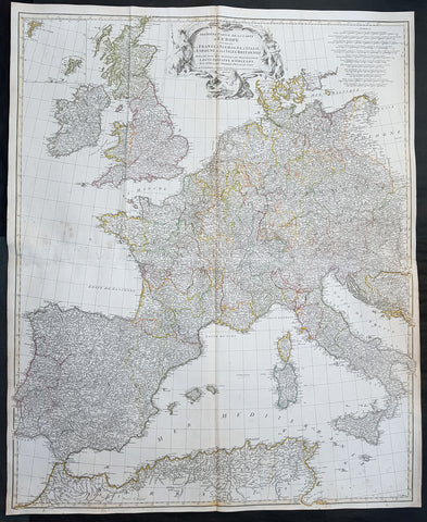
1754 D Anville Large Original Antique Map of Western Europe British Isles - Rare
- Title : Premiere Partie De La Carte D Europe...MDCCLIV
- Size: 39 1/2in x 33in (1.03m x 840mm)
- Ref #: 92307
- Date : 1754
- Condition: (A+) Fine Condition
Description:
This large finely engraved scarce and highly detailed original antique map of contemporary Western Europe and the British Isles was engraved by Guillaume de la Haye in 1754 - dated in the tile cartouche - and was published in Jean-Baptiste Bourguinon D\'Anville\'s large elephant folio atlas Atlas Generale.
General Definitions:
Paper thickness and quality: - Heavy and stable
Paper color : - off white
Age of map color: - Original
Colors used: - Pink, yellow, green, blue
General color appearance: - Authentic
Paper size: - 39 1/2in x 33in (1.03m x 840mm)
Plate size: - 38in x 32in (970mm x 815mm)
Margins: - Min 1/2in (12mm)
Imperfections:
Margins: - None
Plate area: - Light spotting, folds as issued
Verso: - Light spotting, folds as issued
Background:
Fantastic historical map showing the fragmented political borders,hand coloured, of Western Europe in the mid 18th century from Poland to France and North Africa, including the British Isles.
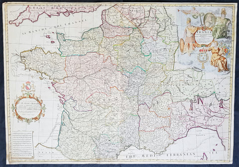
1720 John Senex Large Antique Pre Revolutionary Map of France in Provinces
- Title : France Corrected from ye Observations made by the Royal Academy of Sciences at Paris by John Senex
- Size: 37in x 26in (940m x 660mm)
- Condition: (A) Very Good Condition
- Date : 1720
- Ref #: 81078
Description:
This large beautifully hand coloured original antique map of France was engraved for John Senex for publication in his Elephant Folio Atlas 1720.
These large scale maps are scarce due mainly to their size. Damage and loss over time is inevitable.
General Definitions:
Paper thickness and quality: - Heavy and stable
Paper color : - off white
Age of map color: - Original & later
Colors used: - Yellow, green, blue, pink
General color appearance: - Authentic
Paper size: - 37in x 26in (940m x 660mm)
Plate size: - 36 1/2in x 25 1/2in (930m x 650mm)
Margins: - Min 1/4in (8mm)
Imperfections:
Margins: - Bottom left corner extended from plate-mark
Plate area: - Folds as issued
Verso: - None
Background:
The history of French cartography can be traced to developments in the Middle Ages. This period was marked by improvements in measuring instruments and also by an upgrade of work in registers of all types.
The first map of France was drawn by Oronce Finé and printed in woodcuts in 1525. It testifies to the will of the political power to mark its presence on the territory; to affirm, to build limits, borders, to arrange its territory, and to consolidate the internal economic markets.
In the sixteenth century, Dieppe appeared as an important school of cartography. Pierre Desceliers allowed the realization of many maps. At the same time, the Portolan maps of the Portuguese sailors had the most recent knowledge obtained by the Dieppois sailors in their exploration of Canada.
Then, cartography progressed more and more, through the development of new techniques and by the will of the political powers to control their territories. Very powerful companies testify support to some of the cartographic missions at the end of the nineteenth century.
There were two decisive stages in cartography. One was determining longitude and latitude. Florence Trystram, 2001, the lawsuit of the stars is an account of the research of three French scientists that was done in South America, 1735-1771.
1743 D Anville & CA Coypel Large Antique Map of Italy, Sicily, Sardinia, Corsica
- Title : L Italie Publiee Sous Les Auspices De Monseigneur Le Duc D Orleans, Premier Prince Du Sang....Par L Sr D Anville...MDCCXLIII
- Date : 1743
- Condition: (A) Very Good Condition
- Ref: 92312
- Size: 32in x 28in (820mm x 710mm)
Description:
This large scarce original copper-plate engraved antique map of contemporary Italy, Sicily, Sardinia, Corsica & Malta by Charles-Antoine Coypel was engraved by Pierre-Alexandre Aveline (1702–1760) (both names engraved under cartouche) in 1743 - dated in cartouche - and was published by Jean-Baptiste Bourguinon D Anvilles in his large elephant folio atlas Atlas Generale.
A scarce and hard to find map with two famous names Charles-Antoine Coypel & Pierre-Alexandre Aveline engraved below the cartouche, I am assuming as both drawer & engraver.
General Definitions:
Paper thickness and quality: - Heavy and stable
Paper color : - off white
Age of map color: -
Colors used: -
General color appearance: -
Paper size: - 32in x 28in (820mm x 710mm)
Plate size: - 31 1/2in x 27in (810mm x 690mm)
Margins: - Min 1/8in (2mm)
Imperfections:
Margins: - Top margin cropped to border
Plate area: - Light creasing
Verso: - Creasing
Background:
Since classical times the countries bordering the enclosed waters of the Mediterranean had been well versed in the use of maps and sea charts and in Italy, more than anywhere else, the traditional knowledge was kept alive during the many hundreds of years following the collapse of the Roman Empire. By the thirteenth and fourteenth centuries the seamen of Venice, Genoa and Amalfi traded to far countries, from the Black Sea ports and the coasts of Palestine and Egypt in the East to Flanders and the southern coasts of England and Ireland in the West, their voyages guided by portulan charts and the use of the newly invented compass. For a time Italian supremacy in cartography passed to Aragon and the Catalan map makers based on Majorca, but by the year 1400 the power and wealth of the city states of Venice, Genoa, Florence and Milan surpassed any in Europe. Florence, especially, under the rule of the Medici family, became not only a great trading and financial centre but also the focal point of the rediscovery of the arts and learning of the ancient world. In this milieu a number of manuscript world maps were produced, of which one by Fra Mauro (c. 1459) is the most notable, but the event of the greatest importance in the history of cartography occurred in the year 1400 when a Florentine, Palla Strozzi, brought from Constantinople a Greek manuscript copy of Claudius Ptolemy\\\'s Geographia, which, 1,250 years after its compilation, came as a revelation to scholars in Western Europe. In the following fifty years or so manuscript copies, translated into Latin and other languages, became available in limited numbers but the invention of movable-type printing transformed the scene: the first copy without maps being printed in 1475 followed by many with copper-engraved maps, at Bologna in 1477, Rome 1478, 1490, 1507 and 1508, and Florence 1482.
About the year 1485 the first book of sea charts, compiled by Bartolommeo dalli Sonetti, was printed in Venice and in the first part of the sixteenth century a number of world maps were published, among them one compiled in 1506 by Giovanni Contarini, engraved by Francesco Rosselli, which was the first printed map to show the discoveries in the New World. In the following years there were many attractive and unusual maps of Islands (Isolano) by Bordone, Camocio and Porcacchi, but more important was the work of Giacomo (Jacopo) Gastaldi, a native of Piedmont who started life as an engineer in the service of the Venetian Republic before turning to cartography as a profession. His maps, produced in great variety and quantity, were beautifully drawn copperplate engravings and his style and techniques were widely copied by his contemporaries. From about 1550 to 1580 many of Gastaldi\\\'s maps appeared in the collections of maps known as Lafreri \\\'atlases\\\', a term applied to groups of maps by different cartographers brought together in one binding. As the contents of such collections varied considerably they were no doubt assembled at the special request of wealthy patrons and are now very rare indeed.
About this time, for a variety of historical and commercial reasons, Italy\\\'s position as the leading trading and financial nation rapidly declined and with it her superiority in cartography was lost to the vigorous new states in the Low Countries. That is not to say, of course, that Italian skills as map makers were lost entirely for it was not until 1620 that the first printed maps of Italy by an Italian, Giovanni Magini, appeared, and much later in the century there were fine maps by Giacomo de Rossi and Vincenzo Coronelli, the latter leading a revival of interest in cartography at the end of the century. Coronelli was also famous for the construction of magnificent large-size globes and for the foundation in Venice in 1680 of the first geographical society.
In the eighteenth century the best-known names are Antonio Zatta, Rizzi-Zannoni and Giovanni Cassini.
We ought to mention the work of Baptista Boazio who drew a series of maps in A Summarie and True Discourse of Sir Francis Drake\\\'s West Indian Voyage, published in 1588-89, and who is especially noted for a very fine map of Ireland printed in 1599 which was incorporated in the later editions of the Ortelius atlases. It is perhaps appropriate also to refer to two English map makers who spent many years in exile in Italy: the first, George Lily, famous for the splendid map of the British Isles issued in Rome in 1546, and the second, Robert Dudley, who exactly one hundred years later was responsible for the finest sea atlas of the day, Dell\\\' Arcano del Mare, published in Florence. Both of these are described in greater detail elsewhere in this handbook. (Ref: Tooley, Koeman)
1855 A D Bache Large Rare Antique Map of Florida - US Coast Survey
- Title : US Coast Survey A D Bache Super. Sketch F Showing the Progress of the Survey in Section VI 1848-55...1855.
- Size: 25in x 18 1/2in (635mm x 470mm)
- Condition: (A+) Fine Condition
- Date : 1855
- Ref #: 93022
Description:
This large, rare, original antique lithograph early map of Florida and the progress of the surveys since 1848 by Alexander Dallas Bache (great-grandson of Benjamin Franklin) in 1855 - dated - was published by the official chart-maker of the United States, the office of The US Coast Survey.
The Office of the Coast Survey, founded in 1807 by President Thomas Jefferson and Secretary of Commerce Albert Gallatin, is the oldest scientific organization in the U.S. Federal Government. Jefferson created the Survey of the Coast, as it was then called, in response to a need for accurate navigational charts of the new nation\'s coasts and harbors.
General Definitions:
Paper thickness and quality: - Heavy and stable
Paper color : - off white
Age of map color: -
Colors used: -
General color appearance: -
Paper size: - 25in x 18 1/2in (635mm x 470mm)
Plate size: - 25in x 18 1/2in (635mm x 470mm)
Margins: - Min 1/2in (12mm)
Imperfections:
Margins: - None
Plate area: - Folds as issued
Verso: - Some folds re-enforced with archival tape
Background:
Florida was the first region of the continental United States to be visited and settled by Europeans. The earliest known European explorers came with the Spanish conquistador Juan Ponce de León. Ponce de León spotted and landed on the peninsula on April 2, 1513. He named the region Florida (land of flowers) The story that he was searching for the Fountain of Youth is mythical and only appeared long after his death.
In May 1539, Conquistador Hernando de Soto skirted the coast of Florida, searching for a deep harbor to land. He described seeing a thick wall of red mangroves spread mile after mile, some reaching as high as 70 feet (21 m), with intertwined and elevated roots making landing difficult. The Spanish introduced Christianity, cattle, horses, sheep, the Castilian language, and more to Florida. Spain established several settlements in Florida, with varying degrees of success. In 1559, Don Tristán de Luna y Arellano established a settlement at present-day Pensacola, making it the first attempted settlement in Florida, but it was mostly abandoned by 1561.
In 1565, the settlement of St. Augustine (San Agustín) was established under the leadership of admiral and governor Pedro Menéndez de Avilés, creating what would become one of the oldest, continuously-occupied European settlements in the continental U.S. and establishing the first generation of Floridanos and the Government of Florida. Spain maintained strategic control over the region by converting the local tribes to Christianity. The marriage between Luisa de Abrego, a free black domestic servant from Seville, and Miguel Rodríguez, a white Segovian, occurred in 1565 in St. Augustine. It is the first recorded Christian marriage in the continental United States.
Some Spanish married or had unions with Pensacola, Creek or African women, both slave and free, and their descendants created a mixed-race population of mestizos and mulattos. The Spanish encouraged slaves from the southern British colonies to come to Florida as a refuge, promising freedom in exchange for conversion to Catholicism. King Charles II of Spain issued a royal proclamation freeing all slaves who fled to Spanish Florida and accepted conversion and baptism. Most went to the area around St. Augustine, but escaped slaves also reached Pensacola. St. Augustine had mustered an all-black militia unit defending Spain as early as 1683.
The geographical area of Florida diminished with the establishment of English settlements to the north and French claims to the west. The English attacked St. Augustine, burning the city and its cathedral to the ground several times. Spain built the Castillo de San Marcos in 1672 and Fort Matanzas in 1742 to defend Floridas capital city from attacks, and to maintain its strategic position in the defense of the Captaincy General of Cuba and the Spanish West Indies.
Florida attracted numerous Africans and African Americans from adjacent British colonies who sought freedom from slavery. In 1738, Governor Manuel de Montiano established Fort Gracia Real de Santa Teresa de Mose near St. Augustine, a fortified town for escaped slaves to whom Montiano granted citizenship and freedom in return for their service in the Florida militia, and which became the first free black settlement legally sanctioned in North America.
In 1763, Spain traded Florida to the Kingdom of Great Britain for control of Havana, Cuba, which had been captured by the British during the Seven Years War. It was part of a large expansion of British territory following their victory in the Seven Years War. A large portion of the Floridano population left, taking along most of the remaining indigenous population to Cuba. The British soon constructed the Kings Road connecting St. Augustine to Georgia. The road crossed the St. Johns River at a narrow point called Wacca Pilatka, or the British name Cow Ford, ostensibly reflecting the fact that cattle were brought across the river there.
The British divided and consolidated the Florida provinces (Las Floridas) into East Florida and West Florida, a division the Spanish government kept after the brief British period. The British government gave land grants to officers and soldiers who had fought in the French and Indian War in order to encourage settlement. In order to induce settlers to move to Florida, reports of its natural wealth were published in England. A large number of British settlers who were described as being energetic and of good character moved to Florida, mostly coming from South Carolina, Georgia and England. There was also a group of settlers who came from the colony of Bermuda. This would be the first permanent English-speaking population in what is now Duval County, Baker County, St. Johns County and Nassau County. The British built good public roads and introduced the cultivation of sugar cane, indigo and fruits as well as the export of lumber.
The British governors were directed to call general assemblies as soon as possible in order to make laws for the Floridas, and in the meantime they were, with the advice of councils, to establish courts. This was the first introduction of the English-derived legal system which Florida still has today, including trial by jury, habeas corpus and county-based government. Neither East Florida nor West Florida sent any representatives to Philadelphia to draft the Declaration of Independence. Florida remained a Loyalist stronghold for the duration of the American Revolution.
Spain regained both East and West Florida after Britains defeat in the American Revolution and the subsequent Treaty of Versailles in 1783, and continued the provincial divisions until 1821.
Defense of Floridas northern border with the United States was minor during the second Spanish period. The region became a haven for escaped slaves and a base for Indian attacks against U.S. territories, and the U.S. pressed Spain for reform.
Americans of English descent and Americans of Scots-Irish descent began moving into northern Florida from the backwoods of Georgia and South Carolina. Though technically not allowed by the Spanish authorities and the Floridan government, they were never able to effectively police the border region and the backwoods settlers from the United States would continue to immigrate into Florida unchecked. These migrants, mixing with the already present British settlers who had remained in Florida since the British period, would be the progenitors of the population known as Florida Crackers.
These American settlers established a permanent foothold in the area and ignored Spanish authorities. The British settlers who had remained also resented Spanish rule, leading to a rebellion in 1810 and the establishment for ninety days of the so-called Free and Independent Republic of West Florida on September 23. After meetings beginning in June, rebels overcame the garrison at Baton Rouge (now in Louisiana), and unfurled the flag of the new republic: a single white star on a blue field. This flag would later become known as the Bonnie Blue Flag.
In 1810, parts of West Florida were annexed by proclamation of President James Madison, who claimed the region as part of the Louisiana Purchase. These parts were incorporated into the newly formed Territory of Orleans. The U.S. annexed the Mobile District of West Florida to the Mississippi Territory in 1812. Spain continued to dispute the area, though the United States gradually increased the area it occupied. In 1812, a group of settlers from Georgia, with de facto support from the U.S. federal government, attempted to overthrow the Floridan government in the province of East Florida. The settlers hoped to convince Floridans to join their cause and proclaim independence from Spain, but the settlers lost their tenuous support from the federal government and abandoned their cause by 1813.
Seminoles based in East Florida began raiding Georgia settlements, and offering havens for runaway slaves. The United States Army led increasingly frequent incursions into Spanish territory, including the 1817–1818 campaign against the Seminole Indians by Andrew Jackson that became known as the First Seminole War. The United States now effectively controlled East Florida. Control was necessary according to Secretary of State John Quincy Adams because Florida had become a derelict open to the occupancy of every enemy, civilized or savage, of the United States, and serving no other earthly purpose than as a post of annoyance to them.
Florida had become a burden to Spain, which could not afford to send settlers or garrisons. Madrid therefore decided to cede the territory to the United States through the Adams–Onís Treaty, which took effect in 1821. President James Monroe was authorized on March 3, 1821 to take possession of East Florida and West Florida for the United States and provide for initial governance. Andrew Jackson, on behalf of the U.S. federal government, served as a military commissioner with the powers of governor of the newly acquired territory for a brief period. On March 30, 1822, the U.S. Congress merged East Florida and part of West Florida into the Florida Territory.
By the early 1800s, Indian removal was a significant issue throughout the southeastern U.S. and also in Florida. In 1830, the U.S. Congress passed the Indian Removal Act and as settlement increased, pressure grew on the U.S. government to remove the Indians from Florida. Seminoles offered sanctuary to blacks, and these became known as the Black Seminoles, and clashes between whites and Indians grew with the influx of new settlers. In 1832, the Treaty of Paynes Landing promised to the Seminoles lands west of the Mississippi River if they agreed to leave Florida. Many Seminole left at this time.
Some Seminoles remained, and the U.S. Army arrived in Florida, leading to the Second Seminole War (1835–1842). Following the war, approximately 3,000 Seminole and 800 Black Seminole were removed to Indian Territory. A few hundred Seminole remained in Florida in the Everglades.
On March 3, 1845, only one day before the end of President John Tylers term in office, Florida became the 27th state to join the United States of America. The state was admitted as a slave state and ceased to be a sanctuary for runaway slaves. Initially its population grew slowly.
As European settlers continued to encroach on Seminole lands, and the United States intervened to move the remaining Seminoles to the West. The Third Seminole War (1855–58) resulted in the forced removal of most of the remaining Seminoles, although hundreds of Seminole Indians remained in the Everglades
American settlers began to establish cotton plantations in north Florida, which required numerous laborers, which they supplied by buying slaves in the domestic market. By 1860, Florida had only 140,424 people, of whom 44% were enslaved. There were fewer than 1,000 free African Americans before the American Civil War.
On January 10, 1861, nearly all delegates in the Florida Legislature approved an ordinance of secession, declaring Florida to be a sovereign and independent nation—an apparent reassertion to the preamble in Floridas Constitution of 1838, in which Florida agreed with Congress to be a Free and Independent State. Although not directly related to the issue of slavery, the ordinance declared Floridas secession from the Union, allowing it to become one of the founding members of the Confederate States, a looser union of states.
The Confederacy received little help from Florida; the 15,000 men it offered were generally sent elsewhere. Instead of men and manufactured goods, Florida did provide salt and, more importantly, beef to feed the Confederate armies. This was particularly important after 1864, when the Confederacy lost control of the Mississippi River, thereby losing access to Texas beef. The largest engagements in the state were the Battle of Olustee, on February 20, 1864, and the Battle of Natural Bridge, on March 6, 1865. Both were Confederate victories. The war ended in 1865.
Following the American Civil War, Floridas congressional representation was restored on June 25, 1868, albeit forcefully after Radical Reconstruction and the installation of unelected government officials under the final authority of federal military commanders. After the Reconstruction period ended in 1876, white Democrats regained power in the state legislature. In 1885, they created a new constitution, followed by statutes through 1889 that disfranchised most blacks and many poor whites.
Until the mid-20th century, Florida was the least populous state in the southern United States. In 1900, its population was only 528,542, of whom nearly 44% were African American, the same proportion as before the Civil War. The boll weevil devastated cotton crops.
Forty thousand blacks, roughly one-fifth of their 1900 population, left the state in the Great Migration. They left due to lynchings and racial violence, and for better opportunities. Disfranchisement for most African Americans in the state persisted until the Civil Rights Movement of the 1960s gained federal legislation in 1965 to enforce protection of their constitutional suffrage.
U.S. Coast Survey (Office of Coast Survey)
The Office of Coast Survey is the official chart-maker of the United States. Set up in 1807, it is one of the U.S. governments oldest scientific organizations. In 1878 it was given the name of Coast and Geodetic Survey (C&GS). In 1970 it became part of the National Oceanic and Atmospheric Administration (NOAA).
The agency was established in 1807 when President Thomas Jefferson signed the document entitled An act to provide for surveying the coasts of the United States. While the bills objective was specific—to produce nautical charts—it reflected larger issues of concern to the new nation: national boundaries, commerce, and defence.
The early years were difficult. Ferdinand Rudolph Hassler, who was eventually to become the agencys first superintendent, went to England to collect scientific instruments but was unable to return through the duration of the War of 1812. After his return, he worked on a survey of the New York Harbor in 1817, but Congress stepped in to suspend the work because of tensions between civilian and military control of the agency. After several years under the control of the U.S. Army, the Survey of the Coast was reestablished in 1832, and President Andrew Jackson appointed Hassler as superintendent.
The U.S. Coast Survey was a civilian agency but, from the beginning, members of the Navy and Army were detailed to service with the Survey, and Navy ships were also detailed to its use. In general, army officers worked on topographic surveys on the land and maps based on the surveys, while navy officers worked on hydrographic surveys in coastal waters.
Alexander Dallas Bache, great-grandson of Benjamin Franklin, was the second Coast Survey superintendent. Bache was a physicist, scientist, and surveyor who established the first magnetic observatory and served as the first president of the National Academy of Sciences. Under Bache, Coast Survey quickly applied its resources to the Union cause during the Civil War. In addition to setting up additional lithographic presses to produce the thousands of charts required by the Navy and other vessels, Bache made a critical decision to send Coast Survey parties to work with blockading squadrons and armies in the field, producing hundreds of maps and charts. Bache detailed these activities in his annual reports to Congress.
Coast Survey cartographer Edwin Hergesheimer created the map showing the density of the slave population in the Southern states.
Bache was also one of four members of the governments Blockade Strategy Board, planning strategy to essentially strangle the South, economically and militarily. On April 16, 1861, President Lincoln issued a proclamation declaring the blockade of ports from South Carolina to Texas. Baches Notes on the Coast provided valuable information for Union naval forces.
Maps were of paramount importance in wartime:
It is certain that accurate maps must form the basis of well-conducted military operations, and that the best time to procure them is not when an attack is impending, or when the army waits, but when there is no hindrance to, or pressure upon, the surveyors. That no coast can be effectively attacked, defended, or blockaded without accurate maps and charts, has been fully proved by the events of the last two years, if, indeed, such a proposition required practical proof.
— Alexander Dallas Bache, 1862 report.
Coast Survey attracted some of the best and brightest scientists and naturalists. It commissioned the naturalist Louis Agassiz to conduct the first scientific study of the Florida reef system. James McNeill Whistler, who went on to paint the iconic Whistlers Mother, was a Coast Survey engraver. The naturalist John Muir was a guide and artist on Survey of the 39th Parallel across the Great Basin of Nevada and Utah.
The agencys men and women (women professionals were hired as early as 1845) led scientific and engineering activities through the decades. In 1926, they started production of aeronautical charts. During the height of the Great Depression, Coast and Geodetic Survey organized surveying parties and field offices that employed over 10,000 people, including many out-of-work engineers.
In World War II, C&GS sent over 1,000 civilian members and more than half of its commissioned officers to serve as hydrographers, artillery surveyors, cartographers, army engineers, intelligence officers, and geophysicists in all theaters of the war. Civilians on the home front produced over 100 million maps and charts for the Allied Forces. Eleven members of the C&GS gave their lives during the war.
Alexander Dallas Bache 1806 – 1867 was an American physicist, scientist, and surveyor who erected coastal fortifications and conducted a detailed survey to map the mid-eastern United States coastline. Originally an army engineer, he later became Superintendent of the U.S. Coast Survey, and built it into the foremost scientific institution in the country before the Civil War.
Alexander Bache was born in Philadelphia, the son of Richard Bache, Jr., and Sophia Burrell Dallas Bache. He came from a prominent family as he was the nephew of Vice-President George M. Dallas and naval hero Alexander J. Dallas. He was the grandson of Secretary of the Treasury Alexander Dallas and was the great-grandson of Benjamin Franklin.
Bache was a professor of natural philosophy and chemistry at the University of Pennsylvania from 1828 to 1841 and again from 1842 to 1843. He spent 1836–1838 in Europe on behalf of the trustees of what became Girard College; he was named president of the college after his return. Abroad, he examined European education systems, and on his return he published a valuable report. From 1839 to 1842, he served as the first president of Central High School of Philadelphia, one of the oldest public high schools in the United States.
In 1843, on the death of Professor Ferdinand Rudolph Hassler, Bache was appointed superintendent of the United States Coast Survey. He convinced the United States Congress of the value of this work and, by means of the liberal aid it granted, he completed the mapping of the whole coast by a skillful division of labor and the erection of numerous observing stations. In addition, magnetic and meteorological data were collected. Bache served as head of the Coast Survey for 24 years (until his death).
1854 A D Bache Large Rare Antique Map of Florida - US Coast Survey
- Title : US Coast Survey A D Bache Super. Sketch F Showing the Progress of the Survey in Section VI 1848-54...1854.
- Size: 25in x 18in (635mm x 460mm)
- Condition: (A+) Fine Condition
- Date : 1854
- Ref #: 93025
Description:
This large, rare, original antique lithograph early map of Florida and the progress of the surveys since 1848 by Alexander Dallas Bache (great-grandson of Benjamin Franklin) in 1854 - dated - was published by the official chart-maker of the United States, the office of The US Coast Survey.
The Office of the Coast Survey, founded in 1807 by President Thomas Jefferson and Secretary of Commerce Albert Gallatin, is the oldest scientific organization in the U.S. Federal Government. Jefferson created the Survey of the Coast, as it was then called, in response to a need for accurate navigational charts of the new nation\'s coasts and harbors.
General Definitions:
Paper thickness and quality: - Heavy and stable
Paper color : - off white
Age of map color: -
Colors used: -
General color appearance: -
Paper size: - 25in x 18in (635mm x 460mm)
Plate size: - 25in x 18in (635mm x 460mm)
Margins: - Min 1/2in (12mm)
Imperfections:
Margins: - None
Plate area: - Folds as issued
Verso: - Some folds re-enforced with archival tape
Background:
Florida was the first region of the continental United States to be visited and settled by Europeans. The earliest known European explorers came with the Spanish conquistador Juan Ponce de León. Ponce de León spotted and landed on the peninsula on April 2, 1513. He named the region Florida (land of flowers) The story that he was searching for the Fountain of Youth is mythical and only appeared long after his death.
In May 1539, Conquistador Hernando de Soto skirted the coast of Florida, searching for a deep harbor to land. He described seeing a thick wall of red mangroves spread mile after mile, some reaching as high as 70 feet (21 m), with intertwined and elevated roots making landing difficult. The Spanish introduced Christianity, cattle, horses, sheep, the Castilian language, and more to Florida. Spain established several settlements in Florida, with varying degrees of success. In 1559, Don Tristán de Luna y Arellano established a settlement at present-day Pensacola, making it the first attempted settlement in Florida, but it was mostly abandoned by 1561.
In 1565, the settlement of St. Augustine (San Agustín) was established under the leadership of admiral and governor Pedro Menéndez de Avilés, creating what would become one of the oldest, continuously-occupied European settlements in the continental U.S. and establishing the first generation of Floridanos and the Government of Florida. Spain maintained strategic control over the region by converting the local tribes to Christianity. The marriage between Luisa de Abrego, a free black domestic servant from Seville, and Miguel Rodríguez, a white Segovian, occurred in 1565 in St. Augustine. It is the first recorded Christian marriage in the continental United States.
Some Spanish married or had unions with Pensacola, Creek or African women, both slave and free, and their descendants created a mixed-race population of mestizos and mulattos. The Spanish encouraged slaves from the southern British colonies to come to Florida as a refuge, promising freedom in exchange for conversion to Catholicism. King Charles II of Spain issued a royal proclamation freeing all slaves who fled to Spanish Florida and accepted conversion and baptism. Most went to the area around St. Augustine, but escaped slaves also reached Pensacola. St. Augustine had mustered an all-black militia unit defending Spain as early as 1683.
The geographical area of Florida diminished with the establishment of English settlements to the north and French claims to the west. The English attacked St. Augustine, burning the city and its cathedral to the ground several times. Spain built the Castillo de San Marcos in 1672 and Fort Matanzas in 1742 to defend Floridas capital city from attacks, and to maintain its strategic position in the defense of the Captaincy General of Cuba and the Spanish West Indies.
Florida attracted numerous Africans and African Americans from adjacent British colonies who sought freedom from slavery. In 1738, Governor Manuel de Montiano established Fort Gracia Real de Santa Teresa de Mose near St. Augustine, a fortified town for escaped slaves to whom Montiano granted citizenship and freedom in return for their service in the Florida militia, and which became the first free black settlement legally sanctioned in North America.
In 1763, Spain traded Florida to the Kingdom of Great Britain for control of Havana, Cuba, which had been captured by the British during the Seven Years War. It was part of a large expansion of British territory following their victory in the Seven Years War. A large portion of the Floridano population left, taking along most of the remaining indigenous population to Cuba. The British soon constructed the Kings Road connecting St. Augustine to Georgia. The road crossed the St. Johns River at a narrow point called Wacca Pilatka, or the British name Cow Ford, ostensibly reflecting the fact that cattle were brought across the river there.
The British divided and consolidated the Florida provinces (Las Floridas) into East Florida and West Florida, a division the Spanish government kept after the brief British period. The British government gave land grants to officers and soldiers who had fought in the French and Indian War in order to encourage settlement. In order to induce settlers to move to Florida, reports of its natural wealth were published in England. A large number of British settlers who were described as being energetic and of good character moved to Florida, mostly coming from South Carolina, Georgia and England. There was also a group of settlers who came from the colony of Bermuda. This would be the first permanent English-speaking population in what is now Duval County, Baker County, St. Johns County and Nassau County. The British built good public roads and introduced the cultivation of sugar cane, indigo and fruits as well as the export of lumber.
The British governors were directed to call general assemblies as soon as possible in order to make laws for the Floridas, and in the meantime they were, with the advice of councils, to establish courts. This was the first introduction of the English-derived legal system which Florida still has today, including trial by jury, habeas corpus and county-based government. Neither East Florida nor West Florida sent any representatives to Philadelphia to draft the Declaration of Independence. Florida remained a Loyalist stronghold for the duration of the American Revolution.
Spain regained both East and West Florida after Britains defeat in the American Revolution and the subsequent Treaty of Versailles in 1783, and continued the provincial divisions until 1821.
Defense of Floridas northern border with the United States was minor during the second Spanish period. The region became a haven for escaped slaves and a base for Indian attacks against U.S. territories, and the U.S. pressed Spain for reform.
Americans of English descent and Americans of Scots-Irish descent began moving into northern Florida from the backwoods of Georgia and South Carolina. Though technically not allowed by the Spanish authorities and the Floridan government, they were never able to effectively police the border region and the backwoods settlers from the United States would continue to immigrate into Florida unchecked. These migrants, mixing with the already present British settlers who had remained in Florida since the British period, would be the progenitors of the population known as Florida Crackers.
These American settlers established a permanent foothold in the area and ignored Spanish authorities. The British settlers who had remained also resented Spanish rule, leading to a rebellion in 1810 and the establishment for ninety days of the so-called Free and Independent Republic of West Florida on September 23. After meetings beginning in June, rebels overcame the garrison at Baton Rouge (now in Louisiana), and unfurled the flag of the new republic: a single white star on a blue field. This flag would later become known as the Bonnie Blue Flag.
In 1810, parts of West Florida were annexed by proclamation of President James Madison, who claimed the region as part of the Louisiana Purchase. These parts were incorporated into the newly formed Territory of Orleans. The U.S. annexed the Mobile District of West Florida to the Mississippi Territory in 1812. Spain continued to dispute the area, though the United States gradually increased the area it occupied. In 1812, a group of settlers from Georgia, with de facto support from the U.S. federal government, attempted to overthrow the Floridan government in the province of East Florida. The settlers hoped to convince Floridans to join their cause and proclaim independence from Spain, but the settlers lost their tenuous support from the federal government and abandoned their cause by 1813.
Seminoles based in East Florida began raiding Georgia settlements, and offering havens for runaway slaves. The United States Army led increasingly frequent incursions into Spanish territory, including the 1817–1818 campaign against the Seminole Indians by Andrew Jackson that became known as the First Seminole War. The United States now effectively controlled East Florida. Control was necessary according to Secretary of State John Quincy Adams because Florida had become a derelict open to the occupancy of every enemy, civilized or savage, of the United States, and serving no other earthly purpose than as a post of annoyance to them.
Florida had become a burden to Spain, which could not afford to send settlers or garrisons. Madrid therefore decided to cede the territory to the United States through the Adams–Onís Treaty, which took effect in 1821. President James Monroe was authorized on March 3, 1821 to take possession of East Florida and West Florida for the United States and provide for initial governance. Andrew Jackson, on behalf of the U.S. federal government, served as a military commissioner with the powers of governor of the newly acquired territory for a brief period. On March 30, 1822, the U.S. Congress merged East Florida and part of West Florida into the Florida Territory.
By the early 1800s, Indian removal was a significant issue throughout the southeastern U.S. and also in Florida. In 1830, the U.S. Congress passed the Indian Removal Act and as settlement increased, pressure grew on the U.S. government to remove the Indians from Florida. Seminoles offered sanctuary to blacks, and these became known as the Black Seminoles, and clashes between whites and Indians grew with the influx of new settlers. In 1832, the Treaty of Paynes Landing promised to the Seminoles lands west of the Mississippi River if they agreed to leave Florida. Many Seminole left at this time.
Some Seminoles remained, and the U.S. Army arrived in Florida, leading to the Second Seminole War (1835–1842). Following the war, approximately 3,000 Seminole and 800 Black Seminole were removed to Indian Territory. A few hundred Seminole remained in Florida in the Everglades.
On March 3, 1845, only one day before the end of President John Tylers term in office, Florida became the 27th state to join the United States of America. The state was admitted as a slave state and ceased to be a sanctuary for runaway slaves. Initially its population grew slowly.
As European settlers continued to encroach on Seminole lands, and the United States intervened to move the remaining Seminoles to the West. The Third Seminole War (1855–58) resulted in the forced removal of most of the remaining Seminoles, although hundreds of Seminole Indians remained in the Everglades
American settlers began to establish cotton plantations in north Florida, which required numerous laborers, which they supplied by buying slaves in the domestic market. By 1860, Florida had only 140,424 people, of whom 44% were enslaved. There were fewer than 1,000 free African Americans before the American Civil War.
On January 10, 1861, nearly all delegates in the Florida Legislature approved an ordinance of secession, declaring Florida to be a sovereign and independent nation—an apparent reassertion to the preamble in Floridas Constitution of 1838, in which Florida agreed with Congress to be a Free and Independent State. Although not directly related to the issue of slavery, the ordinance declared Floridas secession from the Union, allowing it to become one of the founding members of the Confederate States, a looser union of states.
The Confederacy received little help from Florida; the 15,000 men it offered were generally sent elsewhere. Instead of men and manufactured goods, Florida did provide salt and, more importantly, beef to feed the Confederate armies. This was particularly important after 1864, when the Confederacy lost control of the Mississippi River, thereby losing access to Texas beef. The largest engagements in the state were the Battle of Olustee, on February 20, 1864, and the Battle of Natural Bridge, on March 6, 1865. Both were Confederate victories. The war ended in 1865.
Following the American Civil War, Floridas congressional representation was restored on June 25, 1868, albeit forcefully after Radical Reconstruction and the installation of unelected government officials under the final authority of federal military commanders. After the Reconstruction period ended in 1876, white Democrats regained power in the state legislature. In 1885, they created a new constitution, followed by statutes through 1889 that disfranchised most blacks and many poor whites.
Until the mid-20th century, Florida was the least populous state in the southern United States. In 1900, its population was only 528,542, of whom nearly 44% were African American, the same proportion as before the Civil War. The boll weevil devastated cotton crops.
Forty thousand blacks, roughly one-fifth of their 1900 population, left the state in the Great Migration. They left due to lynchings and racial violence, and for better opportunities. Disfranchisement for most African Americans in the state persisted until the Civil Rights Movement of the 1960s gained federal legislation in 1965 to enforce protection of their constitutional suffrage.
U.S. Coast Survey (Office of Coast Survey)
The Office of Coast Survey is the official chart-maker of the United States. Set up in 1807, it is one of the U.S. governments oldest scientific organizations. In 1878 it was given the name of Coast and Geodetic Survey (C&GS). In 1970 it became part of the National Oceanic and Atmospheric Administration (NOAA).
The agency was established in 1807 when President Thomas Jefferson signed the document entitled An act to provide for surveying the coasts of the United States. While the bills objective was specific—to produce nautical charts—it reflected larger issues of concern to the new nation: national boundaries, commerce, and defence.
The early years were difficult. Ferdinand Rudolph Hassler, who was eventually to become the agencys first superintendent, went to England to collect scientific instruments but was unable to return through the duration of the War of 1812. After his return, he worked on a survey of the New York Harbor in 1817, but Congress stepped in to suspend the work because of tensions between civilian and military control of the agency. After several years under the control of the U.S. Army, the Survey of the Coast was reestablished in 1832, and President Andrew Jackson appointed Hassler as superintendent.
The U.S. Coast Survey was a civilian agency but, from the beginning, members of the Navy and Army were detailed to service with the Survey, and Navy ships were also detailed to its use. In general, army officers worked on topographic surveys on the land and maps based on the surveys, while navy officers worked on hydrographic surveys in coastal waters.
Alexander Dallas Bache, great-grandson of Benjamin Franklin, was the second Coast Survey superintendent. Bache was a physicist, scientist, and surveyor who established the first magnetic observatory and served as the first president of the National Academy of Sciences. Under Bache, Coast Survey quickly applied its resources to the Union cause during the Civil War. In addition to setting up additional lithographic presses to produce the thousands of charts required by the Navy and other vessels, Bache made a critical decision to send Coast Survey parties to work with blockading squadrons and armies in the field, producing hundreds of maps and charts. Bache detailed these activities in his annual reports to Congress.
Coast Survey cartographer Edwin Hergesheimer created the map showing the density of the slave population in the Southern states.
Bache was also one of four members of the governments Blockade Strategy Board, planning strategy to essentially strangle the South, economically and militarily. On April 16, 1861, President Lincoln issued a proclamation declaring the blockade of ports from South Carolina to Texas. Baches Notes on the Coast provided valuable information for Union naval forces.
Maps were of paramount importance in wartime:
It is certain that accurate maps must form the basis of well-conducted military operations, and that the best time to procure them is not when an attack is impending, or when the army waits, but when there is no hindrance to, or pressure upon, the surveyors. That no coast can be effectively attacked, defended, or blockaded without accurate maps and charts, has been fully proved by the events of the last two years, if, indeed, such a proposition required practical proof.
— Alexander Dallas Bache, 1862 report.
Coast Survey attracted some of the best and brightest scientists and naturalists. It commissioned the naturalist Louis Agassiz to conduct the first scientific study of the Florida reef system. James McNeill Whistler, who went on to paint the iconic Whistlers Mother, was a Coast Survey engraver. The naturalist John Muir was a guide and artist on Survey of the 39th Parallel across the Great Basin of Nevada and Utah.
The agencys men and women (women professionals were hired as early as 1845) led scientific and engineering activities through the decades. In 1926, they started production of aeronautical charts. During the height of the Great Depression, Coast and Geodetic Survey organized surveying parties and field offices that employed over 10,000 people, including many out-of-work engineers.
In World War II, C&GS sent over 1,000 civilian members and more than half of its commissioned officers to serve as hydrographers, artillery surveyors, cartographers, army engineers, intelligence officers, and geophysicists in all theaters of the war. Civilians on the home front produced over 100 million maps and charts for the Allied Forces. Eleven members of the C&GS gave their lives during the war.
Alexander Dallas Bache 1806 – 1867 was an American physicist, scientist, and surveyor who erected coastal fortifications and conducted a detailed survey to map the mid-eastern United States coastline. Originally an army engineer, he later became Superintendent of the U.S. Coast Survey, and built it into the foremost scientific institution in the country before the Civil War.
Alexander Bache was born in Philadelphia, the son of Richard Bache, Jr., and Sophia Burrell Dallas Bache. He came from a prominent family as he was the nephew of Vice-President George M. Dallas and naval hero Alexander J. Dallas. He was the grandson of Secretary of the Treasury Alexander Dallas and was the great-grandson of Benjamin Franklin.
Bache was a professor of natural philosophy and chemistry at the University of Pennsylvania from 1828 to 1841 and again from 1842 to 1843. He spent 1836–1838 in Europe on behalf of the trustees of what became Girard College; he was named president of the college after his return. Abroad, he examined European education systems, and on his return he published a valuable report. From 1839 to 1842, he served as the first president of Central High School of Philadelphia, one of the oldest public high schools in the United States.
In 1843, on the death of Professor Ferdinand Rudolph Hassler, Bache was appointed superintendent of the United States Coast Survey. He convinced the United States Congress of the value of this work and, by means of the liberal aid it granted, he completed the mapping of the whole coast by a skillful division of labor and the erection of numerous observing stations. In addition, magnetic and meteorological data were collected. Bache served as head of the Coast Survey for 24 years (until his death).
1855 A D Bache Scarce Antique Map of Galveston Island & Galveston Bay, Texas
- Title : US Coast Survey A D Buache Supt Preliminary Chart of Galveston Bay Texas....1855
- Size: 22 1/2in x 18 1/2in (565mm x 470mm)
- Condition: (A+) Fine Condition
- Date : 1855
- Ref #: 93027
Description:
This large rare, original lithograph early antique map of Galveston Island & Galveston Bay, Texas by Alexander Dallas Bache (great-grandson of Benjamin Franklin) in 1855 - dated - was published by the official chart-maker of the United States, the office of The US Coast Survey.
The Office of the Coast Survey, founded in 1807 by President Thomas Jefferson and Secretary of Commerce Albert Gallatin, is the oldest scientific organization in the U.S. Federal Government. Jefferson created the Survey of the Coast, as it was then called, in response to a need for accurate navigational charts of the new nation\\\'s coasts and harbors.
General Definitions:
Paper thickness and quality: - Heavy and stable
Paper color : - off white
Age of map color: -
Colors used: -
General color appearance: -
Paper size: - 22 1/2in x 18 1/2in (565mm x 470mm)
Plate size: - 22 1/2in x 18 1/2in (565mm x 470mm)
Margins: - Min 1/2in (12mm)
Imperfections:
Margins: - None
Plate area: - Folds as issued, light age toning
Verso: - Some folds re-enforced with archival tape
Background:
Galveston Island was originally inhabited by members of the Karankawa and Akokisa tribes who called the island Auia. The Spanish explorer Cabeza de Vaca and his crew were shipwrecked on the island or nearby in November 1528, calling it Isla de Malhado (Isle of Bad Fate). They began their years-long trek to a Spanish settlement in Mexico City. During his charting of the Gulf Coast in 1785, the Spanish explorer José de Evia named the island Villa Gálvez or Gálveztown in honor of Bernardo de Gálvez y Madrid, Count of Gálvez (1746-1786).
The islands first permanent European settlements were constructed around 1816 by the pirate Louis-Michel Aury to support Mexicos rebellion against Spain. In 1817, Aury returned from an unsuccessful raid against Spain to find Galveston occupied by the pirate Jean Lafitte. Lafitte organized Galveston into a pirate kingdom he called Campeche, anointing himself the islands head of government. Lafitte remained in Galveston until 1821, when the United States Navy forced him and his raiders off the island.
In 1825 the Congress of Mexico established the Port of Galveston and in 1830 erected a customs house. Galveston served as the capital of the Republic of Texas when in 1836 the interim president David G. Burnet relocated his government there. In 1836, the French-Canadian Michel Branamour Menard and several associates purchased 4,605 acres (18.64 km2) of land for $50,000 to found the town that would become the modern city of Galveston. As Anglo-Americans migrated to the city, they brought along or purchased enslaved African-Americans, some of whom worked domestically or on the waterfront, including on riverboats.
In 1839, the City of Galveston adopted a charter and was incorporated by the Congress of the Republic of Texas. The city was by then a burgeoning port of entry and attracted many new residents in the 1840s and later among the flood of German immigrants to Texas, including Jewish merchants. Together with ethnic Mexican residents, these groups tended to oppose slavery, support the Union during the Civil War, and join the Republican Party after the war.
During this expansion, the city had many firsts in the state, with the founding of institutions and adoption of inventions: post office (1836), naval base (1836), Texas chapter of a Masonic order (1840); cotton compress (1842), Catholic parochial school (Ursuline Academy) (1847), insurance company (1854), and gas lights (1856).
During the American Civil War, Confederate forces under Major General John B. Magruder attacked and expelled occupying Union troops from the city in January 1863 in the Battle of Galveston. In 1867 Galveston suffered a yellow fever epidemic; 1800 people died in the city. These occurred in waterfront and river cities throughout the 19th century, as did cholera epidemics.
The citys progress continued through the Reconstruction era with numerous firsts: construction of the opera house (1870), and orphanage (1876), and installation of telephone lines (1878) and electric lights (1883). Having attracted freedmen from rural areas, in 1870 the city had a black population that totaled 3,000, made up mostly of former slaves but also by persons who were free men of color and educated before the war. The blacks comprised nearly 25% of the citys population of 13,818 that year.
During the post-Civil-War period, leaders such as George T. Ruby and Norris Wright Cuney, who headed the Texas Republican Party and promoted civil rights for freedmen, helped to dramatically improve educational and employment opportunities for blacks in Galveston and in Texas. Cuney established his own business of stevedores and a union of black dockworkers to break the white monopoly on dock jobs. Galveston was a cosmopolitan city and one of the more successful during Reconstruction; the Freedmens Bureau was headquartered here. German families sheltered teachers from the North, and hundreds of freedmen were taught to read. Its business community promoted progress, and immigrants stayed after arriving at this port of entry.
By the end of the 19th century, the city of Galveston had a population of 37,000. Its position on the natural harbor of Galveston Bay along the Gulf of Mexico made it the center of trade in Texas. It was one of the nations largest cotton ports, in competition with New Orleans. Throughout the 19th century, the port city of Galveston grew rapidly and the Strand was considered the regions primary business center. For a time, the Strand was known as the Wall Street of the South. In the late 1890s, the government constructed Fort Crockett defenses and coastal artillery batteries in Galveston and along the Bolivar Roads. In February 1897, the USS Texas (nicknamed Old Hoodoo), the first commissioned battleship of the United States Navy, visited Galveston. During the festivities, the ships officers were presented with a $5,000 silver service, adorned with various Texas motifs, as a gift from the states citizens.
Background:
One of the better mid 19th century large format maps of Martha\'s Vineyard. This rare map depicts most of the island of Marthas Vineyard though does cut out its southwestern portion. Towns, villages, farms, and roads are all beautifully rendered. So too are nautical indications, oceanic depths, and undersea features. There are views of both Holmes\' Hole Harbor and the entrance to Muskeget Channel. There is also a Telescopic view of the Cape Poge lighthouse. This map was created under the direction of A. D. Bache, Superintendent of the Survey of the Coast of the United States and one of the most influential American cartographers of the 19th century.
U.S. Coast Survey (Office of Coast Survey)
The Office of Coast Survey is the official chart-maker of the United States. Set up in 1807, it is one of the U.S. governments oldest scientific organizations. In 1878 it was given the name of Coast and Geodetic Survey (C&GS). In 1970 it became part of the National Oceanic and Atmospheric Administration (NOAA).
The agency was established in 1807 when President Thomas Jefferson signed the document entitled An act to provide for surveying the coasts of the United States. While the bills objective was specific—to produce nautical charts—it reflected larger issues of concern to the new nation: national boundaries, commerce, and defence.
The early years were difficult. Ferdinand Rudolph Hassler, who was eventually to become the agencys first superintendent, went to England to collect scientific instruments but was unable to return through the duration of the War of 1812. After his return, he worked on a survey of the New York Harbor in 1817, but Congress stepped in to suspend the work because of tensions between civilian and military control of the agency. After several years under the control of the U.S. Army, the Survey of the Coast was reestablished in 1832, and President Andrew Jackson appointed Hassler as superintendent.
The U.S. Coast Survey was a civilian agency but, from the beginning, members of the Navy and Army were detailed to service with the Survey, and Navy ships were also detailed to its use. In general, army officers worked on topographic surveys on the land and maps based on the surveys, while navy officers worked on hydrographic surveys in coastal waters.
Alexander Dallas Bache, great-grandson of Benjamin Franklin, was the second Coast Survey superintendent. Bache was a physicist, scientist, and surveyor who established the first magnetic observatory and served as the first president of the National Academy of Sciences. Under Bache, Coast Survey quickly applied its resources to the Union cause during the Civil War. In addition to setting up additional lithographic presses to produce the thousands of charts required by the Navy and other vessels, Bache made a critical decision to send Coast Survey parties to work with blockading squadrons and armies in the field, producing hundreds of maps and charts. Bache detailed these activities in his annual reports to Congress.
Coast Survey cartographer Edwin Hergesheimer created the map showing the density of the slave population in the Southern states.
Bache was also one of four members of the governments Blockade Strategy Board, planning strategy to essentially strangle the South, economically and militarily. On April 16, 1861, President Lincoln issued a proclamation declaring the blockade of ports from South Carolina to Texas. Baches Notes on the Coast provided valuable information for Union naval forces.
Maps were of paramount importance in wartime:
It is certain that accurate maps must form the basis of well-conducted military operations, and that the best time to procure them is not when an attack is impending, or when the army waits, but when there is no hindrance to, or pressure upon, the surveyors. That no coast can be effectively attacked, defended, or blockaded without accurate maps and charts, has been fully proved by the events of the last two years, if, indeed, such a proposition required practical proof.
— Alexander Dallas Bache, 1862 report.
Coast Survey attracted some of the best and brightest scientists and naturalists. It commissioned the naturalist Louis Agassiz to conduct the first scientific study of the Florida reef system. James McNeill Whistler, who went on to paint the iconic Whistlers Mother, was a Coast Survey engraver. The naturalist John Muir was a guide and artist on Survey of the 39th Parallel across the Great Basin of Nevada and Utah.
The agencys men and women (women professionals were hired as early as 1845) led scientific and engineering activities through the decades. In 1926, they started production of aeronautical charts. During the height of the Great Depression, Coast and Geodetic Survey organized surveying parties and field offices that employed over 10,000 people, including many out-of-work engineers.
In World War II, C&GS sent over 1,000 civilian members and more than half of its commissioned officers to serve as hydrographers, artillery surveyors, cartographers, army engineers, intelligence officers, and geophysicists in all theaters of the war. Civilians on the home front produced over 100 million maps and charts for the Allied Forces. Eleven members of the C&GS gave their lives during the war.
Alexander Dallas Bache 1806 – 1867 was an American physicist, scientist, and surveyor who erected coastal fortifications and conducted a detailed survey to map the mid-eastern United States coastline. Originally an army engineer, he later became Superintendent of the U.S. Coast Survey, and built it into the foremost scientific institution in the country before the Civil War.
Alexander Bache was born in Philadelphia, the son of Richard Bache, Jr., and Sophia Burrell Dallas Bache. He came from a prominent family as he was the nephew of Vice-President George M. Dallas and naval hero Alexander J. Dallas. He was the grandson of Secretary of the Treasury Alexander Dallas and was the great-grandson of Benjamin Franklin.
Bache was a professor of natural philosophy and chemistry at the University of Pennsylvania from 1828 to 1841 and again from 1842 to 1843. He spent 1836–1838 in Europe on behalf of the trustees of what became Girard College; he was named president of the college after his return. Abroad, he examined European education systems, and on his return he published a valuable report. From 1839 to 1842, he served as the first president of Central High School of Philadelphia, one of the oldest public high schools in the United States.
In 1843, on the death of Professor Ferdinand Rudolph Hassler, Bache was appointed superintendent of the United States Coast Survey. He convinced the United States Congress of the value of this work and, by means of the liberal aid it granted, he completed the mapping of the whole coast by a skillful division of labor and the erection of numerous observing stations. In addition, magnetic and meteorological data were collected. Bache served as head of the Coast Survey for 24 years (until his death).
1855 US Coast Survey Large Antique Map NW Coast of America, California, Oregon
- Title : US Coast survey A D Bache Reconnaissance of the Western Coast of the United States (northern sheet) from Umpquah River to the Boundary...1855
- Size: 27 1/2in x 23 1/2in (700mm x 590mm)
- Condition: (A) Very Good Condition
- Date : 1855
- Ref #: 93032-1
Description:
This large, scarce original lithograph antique map of the US NW from the Oregon-California border northward to Vancouver Island and the Straits of Juan de Fuca, with eight coastal views, by Alexander Dallas Bache (great-grandson of Benjamin Franklin) in 1855 - dated - was published by the official chart-maker of the United States, the office of The US Coast Survey.
The Office of the Coast Survey, founded in 1807 by President Thomas Jefferson and Secretary of Commerce Albert Gallatin, is the oldest scientific organization in the U.S. Federal Government. Jefferson created the Survey of the Coast, as it was then called, in response to a need for accurate navigational charts of the new nation\\\'s coasts and harbors.
General Definitions:
Paper thickness and quality: - Heavy and stable
Paper color : - off white
Age of map color: -
Colors used: -
General color appearance: -
Paper size: - 27 1/2in x 23 1/2in (700mm x 590mm)
Plate size: - 27 1/2in x 23 1/2in (700mm x 590mm)
Margins: - Min 1/2in (12mm)
Imperfections:
Margins: - Folds as issued
Plate area: - Folds as issued
Verso: - Some folds re-enforced with archival tape
Background:
One of the most attractive coastal charts of the western United States. A rare 1855 coastal chart of the coastline of the United States Pacific Northwest, including the modern day states of Washington and Oregon. Map extends from the Oregon-California border northward to Vancouver Island and the Straits of Juan de Fuca. Features eight coastal views: \'Cape Perpetua N. by w. ½ W,\' \'Cape Lookout N. by W.,\' Tillamook Head N. by W. ½ W.,\' \'Sail Rock,\' \'Destruction Island N. W.,\' \'Flattery Rocks N.W. by N.,\' \'Tatoosh I. North,\' and \'Entrance to Columbia River, Cape Disappointment E. by N..\' Depths sounding all along the coast with various points, harbors, and lookouts well noted. Upper Left quadrant features tidal notations and sailing instructions. Inland, Steilacoom, Olympia, and Seattle are all noted on the Puget Sound. The hydrography for this region was accomplished by James Alden and the geography by G. Davidson. Published under the supervision of A. D. Bache for the 1864 Report of the Superintendent of the U.S. Coast Survey.
U.S. Coast Survey (Office of Coast Survey)
The Office of Coast Survey is the official chart-maker of the United States. Set up in 1807, it is one of the U.S. governments oldest scientific organizations. In 1878 it was given the name of Coast and Geodetic Survey (C&GS). In 1970 it became part of the National Oceanic and Atmospheric Administration (NOAA).
The agency was established in 1807 when President Thomas Jefferson signed the document entitled An act to provide for surveying the coasts of the United States. While the bills objective was specific—to produce nautical charts—it reflected larger issues of concern to the new nation: national boundaries, commerce, and defence.
The early years were difficult. Ferdinand Rudolph Hassler, who was eventually to become the agencys first superintendent, went to England to collect scientific instruments but was unable to return through the duration of the War of 1812. After his return, he worked on a survey of the New York Harbor in 1817, but Congress stepped in to suspend the work because of tensions between civilian and military control of the agency. After several years under the control of the U.S. Army, the Survey of the Coast was reestablished in 1832, and President Andrew Jackson appointed Hassler as superintendent.
The U.S. Coast Survey was a civilian agency but, from the beginning, members of the Navy and Army were detailed to service with the Survey, and Navy ships were also detailed to its use. In general, army officers worked on topographic surveys on the land and maps based on the surveys, while navy officers worked on hydrographic surveys in coastal waters.
Alexander Dallas Bache, great-grandson of Benjamin Franklin, was the second Coast Survey superintendent. Bache was a physicist, scientist, and surveyor who established the first magnetic observatory and served as the first president of the National Academy of Sciences. Under Bache, Coast Survey quickly applied its resources to the Union cause during the Civil War. In addition to setting up additional lithographic presses to produce the thousands of charts required by the Navy and other vessels, Bache made a critical decision to send Coast Survey parties to work with blockading squadrons and armies in the field, producing hundreds of maps and charts. Bache detailed these activities in his annual reports to Congress.
Coast Survey cartographer Edwin Hergesheimer created the map showing the density of the slave population in the Southern states.
Bache was also one of four members of the governments Blockade Strategy Board, planning strategy to essentially strangle the South, economically and militarily. On April 16, 1861, President Lincoln issued a proclamation declaring the blockade of ports from South Carolina to Texas. Baches Notes on the Coast provided valuable information for Union naval forces.
Maps were of paramount importance in wartime:
It is certain that accurate maps must form the basis of well-conducted military operations, and that the best time to procure them is not when an attack is impending, or when the army waits, but when there is no hindrance to, or pressure upon, the surveyors. That no coast can be effectively attacked, defended, or blockaded without accurate maps and charts, has been fully proved by the events of the last two years, if, indeed, such a proposition required practical proof.
— Alexander Dallas Bache, 1862 report.
Coast Survey attracted some of the best and brightest scientists and naturalists. It commissioned the naturalist Louis Agassiz to conduct the first scientific study of the Florida reef system. James McNeill Whistler, who went on to paint the iconic Whistlers Mother, was a Coast Survey engraver. The naturalist John Muir was a guide and artist on Survey of the 39th Parallel across the Great Basin of Nevada and Utah.
The agencys men and women (women professionals were hired as early as 1845) led scientific and engineering activities through the decades. In 1926, they started production of aeronautical charts. During the height of the Great Depression, Coast and Geodetic Survey organized surveying parties and field offices that employed over 10,000 people, including many out-of-work engineers.
In World War II, C&GS sent over 1,000 civilian members and more than half of its commissioned officers to serve as hydrographers, artillery surveyors, cartographers, army engineers, intelligence officers, and geophysicists in all theaters of the war. Civilians on the home front produced over 100 million maps and charts for the Allied Forces. Eleven members of the C&GS gave their lives during the war.
Alexander Dallas Bache 1806 – 1867 was an American physicist, scientist, and surveyor who erected coastal fortifications and conducted a detailed survey to map the mid-eastern United States coastline. Originally an army engineer, he later became Superintendent of the U.S. Coast Survey, and built it into the foremost scientific institution in the country before the Civil War.
Alexander Bache was born in Philadelphia, the son of Richard Bache, Jr., and Sophia Burrell Dallas Bache. He came from a prominent family as he was the nephew of Vice-President George M. Dallas and naval hero Alexander J. Dallas. He was the grandson of Secretary of the Treasury Alexander Dallas and was the great-grandson of Benjamin Franklin.
Bache was a professor of natural philosophy and chemistry at the University of Pennsylvania from 1828 to 1841 and again from 1842 to 1843. He spent 1836–1838 in Europe on behalf of the trustees of what became Girard College; he was named president of the college after his return. Abroad, he examined European education systems, and on his return he published a valuable report. From 1839 to 1842, he served as the first president of Central High School of Philadelphia, one of the oldest public high schools in the United States.
In 1843, on the death of Professor Ferdinand Rudolph Hassler, Bache was appointed superintendent of the United States Coast Survey. He convinced the United States Congress of the value of this work and, by means of the liberal aid it granted, he completed the mapping of the whole coast by a skillful division of labor and the erection of numerous observing stations. In addition, magnetic and meteorological data were collected. Bache served as head of the Coast Survey for 24 years (until his death).
Please note all items auctioned are genuine, we do not sell reproductions. A Certificate of Authenticity (COA) can be issued on request.
1720 Herman Moll Large Antique Map of France in Provinces - Pre Revolution
- Title : A New and Exact Map of France Divided into all its Provinces...by H Moll Geographer
- Ref #: 93416
- Size: 40in x 24 1/2in (1.010m x 625mm)
- Date : 1720
- Condition: (A+) Fine Condition
Description:
This very large beautifully hand coloured original copper-plate engraved antique map of France by Herman Moll was published in 1720 in the atlas The World Described, or a New and Correct Sett of Maps by John Bowles, Thomas Bowles, Philip Overton & John King of London.
In the 18th century many large-scale maps were published by the likes of John Senex and Herman Moll, this trend continued until the end of private mapping in the early 19th century when it was replaced by Ordnance Survey maps.
General Definitions:
Paper thickness and quality: - Heavy and stable
Paper color : - off white
Age of map color: - Early
Colors used: - Yellow, green, blue, pink
General color appearance: - Authentic
Paper size: - 40in x 24 1/2in (1.010m x 625mm)
Plate size: - 39 1/2in x 24in (1.00m x 620mm)
Margins: - Min 1/8in (3mm)
Imperfections:
Margins: - Bottom margin cropped to plate mark
Plate area: - Folds as issued
Verso: - Folds as issued
Background:
The Carolingian dynasty ruled France until 987, when Hugh Capet, Duke of France and Count of Paris, was crowned King of the Franks. His descendants—the Capetians, the House of Valois, and the House of Bourbon—progressively unified the country through wars and dynastic inheritance into the Kingdom of France, which was fully declared in 1190 by Philip II Augustus. The French nobility played a prominent role in most Crusades in order to restore Christian access to the Holy Land. French knights made up the bulk of the steady flow of reinforcements throughout the two-hundred-year span of the Crusades, in such a fashion that the Arabs uniformly referred to the crusaders as Franj caring little whether they really came from France. The French Crusaders also imported the French language into the Levant, making French the base of the lingua franca (litt. Frankish language) of the Crusader states. French knights also made up the majority in both the Hospital and the Temple orders. The latter, in particular, held numerous properties throughout France and by the 13th century were the principal bankers for the French crown, until Philip IV annihilated the order in 1307. The Albigensian Crusade was launched in 1209 to eliminate the heretical Cathars in the southwestern area of modern-day France. In the end, the Cathars were exterminated and the autonomous County of Toulouse was annexed into the crown lands of France. Later kings expanded their domain to cover over half of modern continental France, including most of the north, centre and west of France. Meanwhile, the royal authority became more and more assertive, centred on a hierarchically conceived society distinguishing nobility, clergy, and commoners.
From the 11th century, the House of Plantagenet, the rulers of the County of Anjou, succeeded in establishing its dominion over the surrounding provinces of Maine and Touraine, then progressively built an empire that spanned from England to the Pyrenees and covering half of modern France. Tensions between the kingdom of France and the Plantagenet empire would last a hundred years, until Philip Augustus of France conquered between 1202 and 1214 most of the continental possessions of the empire, leaving England and Aquitaine to the Plantagenets. Following the Battle of Bouvines, the Angevin court retreated to England, but persistent Capetian–Plantagenet rivalry would paved the way for another conflict.
Charles IV the Fair died without an heir in 1328. Under the rules of the Salic law the crown of France could not pass to a woman nor could the line of kingship pass through the female line. Accordingly, the crown passed to Philip of Valois, a cousin of Charles, rather than through the female line to Charles nephew, Edward of Plantagenet, who would soon become Edward III of England. During the reign of Philip of Valois, the French monarchy reached the height of its medieval power. Philips seat on the throne was contested by Edward III of England and in 1337, on the eve of the first wave of the Black Death, England and France went to war in what would become known as the Hundred Years War. The exact boundaries changed greatly with time, but French landholdings of the English Kings remained extensive for decades. With charismatic leaders, such as Joan of Arc and La Hire, strong French counterattacks won back English continental territories. Like the rest of Europe, France was struck by the Black Death; half of the 17 million population of France died.
The French Renaissance saw a spectacular cultural development and the first standardisation of the French language, which would become the official language of France and the language of Europes aristocracy. It also saw a long set of wars, known as the Italian Wars, between France and the House of Habsburg. French explorers, such as Jacques Cartier or Samuel de Champlain, claimed lands in the Americas for France, paving the way for the expansion of the First French colonial empire. The rise of Protestantism in Europe led France to a civil war known as the French Wars of Religion, where, in the most notorious incident, thousands of Huguenots were murdered in the St. Bartholomews Day massacre of 1572. The Wars of Religion were ended by Henry IVs Edict of Nantes, which granted some freedom of religion to the Huguenots. Spanish troops, the terror of Western Europe, assisted the Catholic side during the Wars of Religion in 1589–1594, and invaded northern France in 1597; after some skirmishing in the 1620s and 1630s, Spain and France returned to all-out war between 1635 and 1659. The war cost France 300,000 casualties.
Under Louis XIII, the energetic Cardinal Richelieu promoted the centralisation of the state and reinforced the royal power by disarming domestic power holders in the 1620s. He systematically destroyed castles of defiant lords and denounced the use of private violence (dueling, carrying weapons, and maintaining private army). By the end of 1620s, Richelieu established the royal monopoly of force as the doctrine. During Louis XIVs minority and the regency of Queen Anne and Cardinal Mazarin, a period of trouble known as the Fronde occurred in France. This rebellion was driven by the great feudal lords and sovereign courts as a reaction to the rise of royal absolute power in France.
The monarchy reached its peak during the 17th century and the reign of Louis XIV. By turning powerful feudal lords into courtiers at the Palace of Versailles, Louis XIVs personal power became unchallenged. Remembered for his numerous wars, he made France the leading European power. France became the most populous country in Europe and had tremendous influence over European politics, economy, and culture. French became the most-used language in diplomacy, science, literature and international affairs, and remained so until the 20th century. France obtained many overseas possessions in the Americas, Africa and Asia. Louis XIV also revoked the Edict of Nantes, forcing thousands of Huguenots into exile.
Under Louis XV, Louis XIVs great-grandson, France lost New France and most of its Indian possessions after its defeat in the Seven Years War (1756–63). Its European territory kept growing, however, with notable acquisitions such as Lorraine (1766) and Corsica (1770). An unpopular king, Louis XVs weak rule, his ill-advised financial, political and military decisions – as well as the debauchery of his court– discredited the monarchy, which arguably paved the way for the French Revolution 15 years after his death.
Louis XVI, Louis XVs grandson, actively supported the Americans, who were seeking their independence from Great Britain (realised in the Treaty of Paris (1783)). The financial crisis aggravated by Frances involvement in the American Revolutionary War was one of many contributing factors to the French Revolution. Much of the Enlightenment occurred in French intellectual circles, and major scientific breakthroughs and inventions, such as the discovery of oxygen (1778) and the first hot air balloon carrying passengers (1783), were achieved by French scientists. French explorers, such as Bougainville and Lapérouse, took part in the voyages of scientific exploration through maritime expeditions around the globe. The Enlightenment philosophy, in which reason is advocated as the primary source for legitimacy and authority, undermined the power of and support for the monarchy and helped pave the way for the French Revolution.
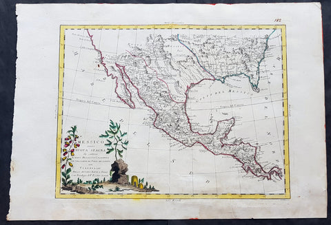
1785 Antonio Zatta Large Antique Map of Mexico, Texas, California, SW & SE USA
- Title : Messico ouvero Nuova Spagna che contiene Il Nuovo Messico La Californoa Con Una Partie de Paesi Adjacenti Venezi 1785
- Size: 21in x 15in (535mm x 385mm)
- Condition: (A+) Fine Condition
- Date : 1785
- Ref #: 93006
Description:
This large beautifully hand coloured original antique map of Mexico including Texas, California, and the SE USA was engraved in 1785 - the date is engraved in the title cartouche - and was published by Antonio Zatta in his Atlas Atlante Novissimo. (Ref: Tooley; M&B)
General Definitions:
Paper thickness and quality: - Heavy and stable
Paper color : - off white
Age of map color: - Original
Colors used: - Blue, pink, red, green, yellow
General color appearance: - Authentic
Paper size: - 21in x 15in (535mm x 385mm)
Plate size: - 16in x 12 1/2in (405mm x 320mm)
Margins: - Min 1in (25mm)
Imperfections:
Margins: - None
Plate area: - None
Verso: - Light age toning
Background:
The capture of Tenochtitlan and refounding of Mexico City in 1521 was the beginning of a 286-year-long colonial era during which Mexico was known as Nueva España (New Spain). The Kingdom of New Spain was created from the remnants of the Aztec hegemonic empire. Subsequent enlargements, such as the conquest of the Tarascan state, resulted in the creation of the Viceroyalty of New Spain in 1535. The Viceroyalty at its greatest extent included the territories of modern Mexico, Central America as far south as Costa Rica, and the western United States. The Viceregal capital Mexico City also administrated the Spanish West Indies (the Caribbean), the Spanish East Indies (the Philippines), and Spanish Florida.
The indigenous population stabilized around one to one and a half million individuals in the 17th century from the most commonly accepted five to ten million pre-contact population. The population decline was primarily the result of communicable diseases, particularly smallpox, introduced during the Columbian Exchange. During the three hundred years of the colonial era, Mexico received between 400,000 and 500,000 Europeans, between 200,000 and 250,000 Africans and between 40,000 and 120,000 Asians. The 18th century saw a great increase in the percentage of mestizos.
Colonial law with Spanish roots was introduced and attached to native customs creating a hierarchy between local jurisdiction (the Cabildos) and the Spanish Crown. Upper administrative offices were closed to native-born people, even those of pure Spanish blood (criollos). Administration was based on the racial separation, among Republics of Spaniards, Amerindians and castas, autonomous and directly dependent on the king himself.
The Council of Indies and the mendicant religious orders, which arrived in Mesoamerica as early as 1524, labored to generate capital for the crown of Spain and convert the Amerindian populations to Catholicism. The 1531 Marian apparitions to Saint Juan Diego gave impetus to the evangelization of central Mexico. The Virgin of Guadalupe became a symbol of criollo patriotism and was used by the insurgents that followed Miguel Hidalgo during the War of Independence. Some Crypto-Jewish families emigrated to Mexico to escape the Spanish Inquisition.
The rich deposits of silver, particularly in Zacatecas and Guanajuato, resulted in silver extraction dominating the economy of New Spain. Taxes on silver production became a major source of income for Spain. Other important industries were the haciendas (functioning under the encomienda and repartimiento systems) and mercantile activities in the main cities and ports. Wealth created during the colonial era spurred the development of New Spanish Baroque.
As a result of its trade links with Asia, the rest of the Americas, Africa and Europe and the profound effect of New World silver, central Mexico was one of the first regions to be incorporated into a globalized economy. Being at the crossroads of trade, people and cultures, Mexico City has been called the first world city. The Nao de China (Manila Galleons) operated for two and a half centuries and connected New Spain with Asia. Goods were taken from Veracruz to Atlantic ports in the Americas and Spain. Veracruz was also the main port of entry in mainland New Spain for European goods, immigrants, and African slaves. The Camino Real de Tierra Adentro connected Mexico City with the interior of New Spain. Mexican silver pesos became the first globally used currency and the silver mined in Mexico were used to run commerce and wage crusades in two sides of globe, at the Mediterranean were Spain fought against the Ottoman Caliphate and at Southeast Asia where the Philippines fought against the Brunei Sultanate.
Due to the importance of New Spain administrative base, Mexico was the location of the first printing shop (1539), first university (1551), first public park (1592), and first public library (1646) in the Americas, amongst other institutions. Important artists of the colonial period, include the writers Juan Ruiz de Alarcón and Sor Juana Inés de la Cruz, painters Cristóbal de Villalpando and Miguel Cabrera, and architect Manuel Tolsá. The Academy of San Carlos was the first major school and museum of art in the Americas. Scientist Andrés Manuel del Río Fernández discovered the element vanadium.
Spanish forces, sometimes accompanied by native allies, led expeditions to conquer territory or quell rebellions through the colonial era. Notable Amerindian revolts in sporadically populated northern New Spain include the Chichimeca War (1576–1606), Tepehuán Revolt (1616–1620) and the Pueblo Revolt (1680). To protect Mexico from the attacks of English, French and Dutch pirates and protect the Crowns monopoly of revenue, only two ports were open to foreign trade—Veracruz on the Atlantic and Acapulco on the Pacific. Among the best-known pirate attacks are the 1663 Sack of Campeche and 1683 Attack on Veracruz.
Many Mexican cultural features including tequila, first distilled in the 16th century, charreria (17th), mariachi (18th) and Mexican cuisine, a fusion of American and European (particularly Spanish) cuisine, arose during the colonial era.
On September 16, 1810, a loyalist revolt against the ruling junta was declared by priest Miguel Hidalgo y Costilla, in the small town of Dolores, Guanajuato. This event, known as the Cry of Dolores (Spanish: Grito de Dolores) is commemorated each year, on September 16, as Mexicos independence day. The first insurgent group was formed by Hidalgo, the Spanish viceregal army captain Ignacio Allende, the militia captain Juan Aldama and La Corregidora Josefa Ortiz de Domínguez. Hidalgo and some of his soldiers were captured and executed by firing squad in Chihuahua, on July 31, 1811. Following his death, the leadership was assumed by priest José María Morelos, who occupied key southern cities.
In 1813 the Congress of Chilpancingo was convened and, on November 6, signed the Solemn Act of the Declaration of Independence of Northern America. Morelos was captured and executed on December 22, 1815.
In subsequent years, the insurgency was near collapse, but in 1820 Viceroy Juan Ruiz de Apodaca sent an army under the criollo general Agustín de Iturbide against the troops of Vicente Guerrero. Instead, Iturbide approached Guerrero to join forces, and on August 24, 1821 representatives of the Spanish Crown and Iturbide signed the Treaty of Córdoba and the Declaration of Independence of the Mexican Empire, which recognized the independence of Mexico under the terms of the Plan of Iguala.
Mexicos short recovery after the War of Independence was soon cut short again by the civil wars and institutional instability of the 1850s, which lasted until the government of Porfirio Díaz reestablished conditions that paved the way for economic growth. The conflicts that arose from the mid-1850s had a profound effect because they were widespread and made themselves perceptible in the vast rural areas of the countries, involved clashes between castes, different ethnic groups and haciendas, and entailed a deepening of the political and ideological divisions between republicans and monarchists.
Agustín de Iturbide became constitutional emperor of the First Mexican Empire in 1822. A revolt against him in 1823 established the United Mexican States. In 1824, a Republican Constitution was drafted and Guadalupe Victoria became the first president of the newly born country. Central America, including Chiapas, left the union. In 1829 president Guerrero abolished slavery. The first decades of the post-independence period were marked by economic instability, which led to the Pastry War in 1836. There was constant strife between Liberals, supporters of a federal form of government, and Conservatives, who proposed a hierarchical form of government.
During this period, the frontier borderlands to the north became quite isolated from the government in Mexico City, and its monopolistic economic policies caused suffering. With limited trade, the people had difficulty meeting tax payments and resented the central governments actions in collecting customs. Resentment built up from California to Texas. Both the mission system and the presidios had collapsed after the Spanish withdrew from the colony, causing great disruption especially in Alta California and New Mexico. The people in the borderlands had to raise local militias to protect themselves from hostile Native Americans. These areas developed in different directions from the center of the country.
Wanting to stabilize and develop the frontier, Mexico encouraged immigration into present-day Texas, as they were unable to persuade people from central Mexico to move into those areas. They allowed for religious freedom for the new settlers, who were primarily Protestant English speakers from the United States. Within several years, the Anglos far outnumbered the Tejano in the area. Itinerant traders traveled through the area, working by free market principles. The Tejano grew more separate from the government and due to its neglect, many supported the idea of independence and joined movements to that end, collaborating with the English-speaking Americans.
General Antonio López de Santa Anna, a centralist and two-time dictator, approved the Siete Leyes in 1836, a radical amendment that institutionalized the centralized form of government. When he suspended the 1824 Constitution, civil war spread across the country. Three new governments declared independence: the Republic of Texas, the Republic of the Rio Grande and the Republic of Yucatán.
The 1846 United States annexation of the Republic of Texas and subsequent American military incursion into territory that was part of Coahuila (also claimed by Texas) instigated the Mexican–American War. The war was settled in 1848 via the Treaty of Guadalupe Hidalgo. Mexico was forced to give up more than one-third of its land to the U.S., including Alta California, Santa Fe de Nuevo México and the territory claimed by Texas. A much smaller transfer of territory in what is today southern Arizona and southwestern New Mexico—known as the Gadsden Purchase—occurred in 1854.
The Caste War of Yucatán, the Maya uprising that began in 1847, was one of the most successful modern Native American revolts. Maya rebels, or Cruzob, maintained relatively independent enclaves in the peninsula until the 1930s.
Dissatisfaction with Santa Annas return to power led to the liberal Plan of Ayutla, initiating an era known as La Reforma. The new Constitution drafted in 1857 established a secular state, federalism as the form of government, and several freedoms. As the Conservatives refused to recognize it, the Reform War began in 1858, during which both groups had their own governments. The war ended in 1861 with victory by the Liberals, led by president Benito Juárez, who was an ethnic Zapotec.
In the 1860s Mexico was occupied by France, which established the Second Mexican Empire under the rule of the Habsburg Archduke Ferdinand Maximilian of Austria with support from the Roman Catholic clergy and the Conservatives. The latter switched sides and joined the Liberals. Maximilian surrendered, was tried on June 14, 1867, and was executed a few days later on June 19 in Querétaro.
1855 A D Bache Large Antique Map of Chesapeake Bay Virginia & Maryland, USA
- Title : US Coast Survey A D Bache Supt Sketch C Showing the Progress of the Survey in Section No. III from 1843 to 1855....1855
- Size: 36in x 24 1/2in (915mm x 615mm)
- Condition: (A) Very Good Condition
- Date : 1855
- Ref #: 93032
Description:
This large scarce, original lithograph early antique map of Chesapeake Bay and Maryland by Alexander Dallas Bache (great-grandson of Benjamin Franklin) in 1855 - dated - was published by the official chart-maker of the United States, the office of The US Coast Survey.
The Office of the Coast Survey, founded in 1807 by President Thomas Jefferson and Secretary of Commerce Albert Gallatin, is the oldest scientific organization in the U.S. Federal Government. Jefferson created the Survey of the Coast, as it was then called, in response to a need for accurate navigational charts of the new nation\\\'s coasts and harbors.
General Definitions:
Paper thickness and quality: - Heavy and stable
Paper color : - off white
Age of map color: -
Colors used: -
General color appearance: -
Paper size: - 36in x 24 1/2in (915mm x 615mm)
Plate size: - 36in x 24 1/2in (915mm x 615mm)
Margins: - Min 1/2in (12mm)
Imperfections:
Margins: - None
Plate area: - Folds as issued, small repair to top fold
Verso: - Some folds re-enforced with archival tape
Background:
In 1524, Italian explorer Giovanni da Verrazzano, (1485–1528), in service of the French crown, (famous for sailing through and thereafter naming the entrance to New York Bay as the Verrazzano Narrows, including now in the 20th century, a suspension bridge also named for him) sailed past the Chesapeake, but did not enter the Bay. Spanish explorer Lucas Vásquez de Ayllón sent an expedition out from Hispaniola in 1525 that reached the mouths of the Chesapeake and Delaware Bays. It may have been the first European expedition to explore parts of the Chesapeake Bay, which the Spaniards called Bahía de Santa María (Bay of St. Mary) or Bahía de Madre de Dios.(Bay of the Mother of God) De Ayllón established a short-lived Spanish mission settlement, San Miguel de Gualdape, in 1526 along the Atlantic coast. Many scholars doubt the assertion that it was as far north as the Chesapeake; most place it in present-day Georgias Sapelo Island. In 1573, Pedro Menéndez de Márquez, the governor of Spanish Florida, conducted further exploration of the Chesapeake. In 1570, Spanish Jesuits established the short-lived Ajacan Mission on one of the Chesapeake tributaries in present-day Virginia.
The arrival of English colonists under Sir Walter Raleigh and Humphrey Gilbert in the late 16th century to found a colony, later settled at Roanoke Island (off the present-day coast of North Carolina) for the Virginia Company, marked the first time that the English approached the gates to the Chesapeake Bay between the capes of Cape Charles and Cape Henry. Three decades later, in 1607, Europeans again entered the Bay. Captain John Smith of England explored and mapped the Bay between 1607 and 1609, resulting in the publication in 1612 back in the British Isles of A Map of Virginia. Smith wrote in his journal: Heaven and earth have never agreed better to frame a place for mans habitation. The new laying out of the Captain John Smith Chesapeake National Historic Trail, the United States first designated all-water National Historic Trail, was created in July 2006, by the National Park Service of the U.S. Department of the Interior following the route of Smiths historic 17th-century voyage. Because of economic hardships and civil strife in the Mother Land, there was a mass migration of southern English Cavaliers and their servants to the Chesapeake Bay region between 1640 and 1675, to both of the new colonies of the Province of Virginia and the Province of Maryland.
The Chesapeake Bay was the site of the Battle of the Chesapeake (also known as the Battle of the Capes, Cape Charles and Cape Henry) in 1781, during which the French fleet defeated the Royal Navy in the decisive naval battle of the American Revolutionary War. The British defeat enabled General George Washington and his French allied armies under Comte de Rochambeau to march down from New York and bottle up the rampaging southern British Army of Lord Cornwallis from the North and South Carolinas at the siege of Battle of Yorktown in Yorktown, Virginia. Their marching route from Newport, Rhode Island through Connecticut, New York State, Pennsylvania, New Jersey and Delaware to the Head of Elk by the Susquehanna River along the shores and also partially sailing down the Bay to Virginia. It is also the subject of a designated National Historic Trail under the National Park Service as the Washington-Rochambeau Revolutionary Route.
The Bay would again see conflict during War of 1812. During the year of 1813, from their base on Tangier Island, British naval forces under the command of Admiral George Cockburn raided and plundered several towns on the shores of the Chesapeake, treating the Bay as if it were a British Lake. The Chesapeake Bay Flotilla, a fleet of shallow-draft armed barges under the command of U.S. Navy Commodore Joshua Barney, was assembled to stall British shore raids and attacks. After months of harassment by Barney, the British landed on the west side of the Patuxent at Benedict, Maryland, the Chesapeake Flotilla was scuttled, and the British trekked overland to burn the U.S. Capitol in August 1814. A few days later in a pincer attack, they also sailed up the Potomac River to attack Fort Washington below the National Capital and demanded a ransom from the nearby port town of Alexandria, Virginia.
There were so-called Oyster Wars in the late 19th and early 20th centuries. Until the mid-20th century, oyster harvesting rivaled the crab industry among Chesapeake watermen, a dwindling breed whose skipjacks and other workboats were supplanted by recreational craft in the latter part of the century.
In the 1960s, the Calvert Cliffs Nuclear Power Plant on the historic Calvert Cliffs in Calvert County on the Western Shore of Maryland began using water from the Bay to cool its reactor.
U.S. Coast Survey (Office of Coast Survey)
The Office of Coast Survey is the official chart-maker of the United States. Set up in 1807, it is one of the U.S. governments oldest scientific organizations. In 1878 it was given the name of Coast and Geodetic Survey (C&GS). In 1970 it became part of the National Oceanic and Atmospheric Administration (NOAA).
The agency was established in 1807 when President Thomas Jefferson signed the document entitled An act to provide for surveying the coasts of the United States. While the bills objective was specific—to produce nautical charts—it reflected larger issues of concern to the new nation: national boundaries, commerce, and defence.
The early years were difficult. Ferdinand Rudolph Hassler, who was eventually to become the agencys first superintendent, went to England to collect scientific instruments but was unable to return through the duration of the War of 1812. After his return, he worked on a survey of the New York Harbor in 1817, but Congress stepped in to suspend the work because of tensions between civilian and military control of the agency. After several years under the control of the U.S. Army, the Survey of the Coast was reestablished in 1832, and President Andrew Jackson appointed Hassler as superintendent.
The U.S. Coast Survey was a civilian agency but, from the beginning, members of the Navy and Army were detailed to service with the Survey, and Navy ships were also detailed to its use. In general, army officers worked on topographic surveys on the land and maps based on the surveys, while navy officers worked on hydrographic surveys in coastal waters.
Alexander Dallas Bache, great-grandson of Benjamin Franklin, was the second Coast Survey superintendent. Bache was a physicist, scientist, and surveyor who established the first magnetic observatory and served as the first president of the National Academy of Sciences. Under Bache, Coast Survey quickly applied its resources to the Union cause during the Civil War. In addition to setting up additional lithographic presses to produce the thousands of charts required by the Navy and other vessels, Bache made a critical decision to send Coast Survey parties to work with blockading squadrons and armies in the field, producing hundreds of maps and charts. Bache detailed these activities in his annual reports to Congress.
Coast Survey cartographer Edwin Hergesheimer created the map showing the density of the slave population in the Southern states.
Bache was also one of four members of the governments Blockade Strategy Board, planning strategy to essentially strangle the South, economically and militarily. On April 16, 1861, President Lincoln issued a proclamation declaring the blockade of ports from South Carolina to Texas. Baches Notes on the Coast provided valuable information for Union naval forces.
Maps were of paramount importance in wartime:
It is certain that accurate maps must form the basis of well-conducted military operations, and that the best time to procure them is not when an attack is impending, or when the army waits, but when there is no hindrance to, or pressure upon, the surveyors. That no coast can be effectively attacked, defended, or blockaded without accurate maps and charts, has been fully proved by the events of the last two years, if, indeed, such a proposition required practical proof.
— Alexander Dallas Bache, 1862 report.
Coast Survey attracted some of the best and brightest scientists and naturalists. It commissioned the naturalist Louis Agassiz to conduct the first scientific study of the Florida reef system. James McNeill Whistler, who went on to paint the iconic Whistlers Mother, was a Coast Survey engraver. The naturalist John Muir was a guide and artist on Survey of the 39th Parallel across the Great Basin of Nevada and Utah.
The agencys men and women (women professionals were hired as early as 1845) led scientific and engineering activities through the decades. In 1926, they started production of aeronautical charts. During the height of the Great Depression, Coast and Geodetic Survey organized surveying parties and field offices that employed over 10,000 people, including many out-of-work engineers.
In World War II, C&GS sent over 1,000 civilian members and more than half of its commissioned officers to serve as hydrographers, artillery surveyors, cartographers, army engineers, intelligence officers, and geophysicists in all theaters of the war. Civilians on the home front produced over 100 million maps and charts for the Allied Forces. Eleven members of the C&GS gave their lives during the war.
Alexander Dallas Bache 1806 – 1867 was an American physicist, scientist, and surveyor who erected coastal fortifications and conducted a detailed survey to map the mid-eastern United States coastline. Originally an army engineer, he later became Superintendent of the U.S. Coast Survey, and built it into the foremost scientific institution in the country before the Civil War.
Alexander Bache was born in Philadelphia, the son of Richard Bache, Jr., and Sophia Burrell Dallas Bache. He came from a prominent family as he was the nephew of Vice-President George M. Dallas and naval hero Alexander J. Dallas. He was the grandson of Secretary of the Treasury Alexander Dallas and was the great-grandson of Benjamin Franklin.
Bache was a professor of natural philosophy and chemistry at the University of Pennsylvania from 1828 to 1841 and again from 1842 to 1843. He spent 1836–1838 in Europe on behalf of the trustees of what became Girard College; he was named president of the college after his return. Abroad, he examined European education systems, and on his return he published a valuable report. From 1839 to 1842, he served as the first president of Central High School of Philadelphia, one of the oldest public high schools in the United States.
In 1843, on the death of Professor Ferdinand Rudolph Hassler, Bache was appointed superintendent of the United States Coast Survey. He convinced the United States Congress of the value of this work and, by means of the liberal aid it granted, he completed the mapping of the whole coast by a skillful division of labor and the erection of numerous observing stations. In addition, magnetic and meteorological data were collected. Bache served as head of the Coast Survey for 24 years (until his death).
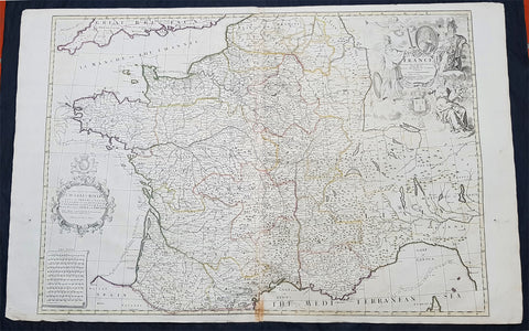
1720 John Senex Large Antique Map of France in Provinces
- Title : France corrected from ye Observations by the Royal Academy Society at Paris by John Senex
- Size: 41 1/2in x 26 1/2in (1.040m x 660mm)
- Condition: (A) Very Good Condition
- Date : 1878
- Ref #: 24903
Description:
This large hand coloured original copper plate engraved antique map of France by John Senex, was published in the 1720 edition of his Elephant Folio Atlas.
This map is in VG condition. These large scale maps are scarce due mainly to their size, with damage and loss over time inevitable.
General Definitions:
Paper thickness and quality: - Heavy and stable
Paper color : - off white
Age of map color: - Original
Colors used: - Yellow, green, blue, pink
General color appearance: - Authentic
Paper size: - 41 1/2in x 26 1/2in (1.040m x 660mm)
Plate size: - 36in x 24 1/2in (915mm x 615mm)
Margins: - Min 1/2in (12mm)
Imperfections:
Margins: - Light chipping to margin edges
Plate area: - Discouloration to bottom centerfold
Verso: - None
Background:
The history of French cartography can be traced to developments in the Middle Ages. This period was marked by improvements in measuring instruments and also by an upgrade of work in registers of all types.
The first map of France was drawn by Oronce Finé and printed in woodcuts in 1525. It testifies to the will of the political power to mark its presence on the territory; to affirm, to build limits, borders, to arrange its territory, and to consolidate the internal economic markets.
In the sixteenth century, Dieppe appeared as an important school of cartography. Pierre Desceliers allowed the realization of many maps. At the same time, the Portolan maps of the Portuguese sailors had the most recent knowledge obtained by the Dieppois sailors in their exploration of Canada.
Then, cartography progressed more and more, through the development of new techniques and by the will of the political powers to control their territories. Very powerful companies testify support to some of the cartographic missions at the end of the nineteenth century.
There were two decisive stages in cartography. One was determining longitude and latitude. Florence Trystram, 2001, the lawsuit of the stars is an account of the research of three French scientists that was done in South America, 1735-1771.
1855 US Coast Survey Large Antique Map Mississippi Delta, Louisiana to Alabama
- Title : US Coast survey A D Bache Superintendant Sketch II Showing the progress of the Survey in Section No. 8 1846-1855...1855
- Size: 35 1/2in x 17in (900mm x 430mm)
- Condition: (A) Very Good Condition
- Date : 1855
- Ref #: 93031
Description:
This large, scarce original lithograph antique map of Mississippi River Delta from Vermillion Bay Louisiana to Mobile Bay, Alabama by Alexander Dallas Bache (great-grandson of Benjamin Franklin) in 1855 - dated - was published by the official chart-maker of the United States, the office of The US Coast Survey.
The Office of the Coast Survey, founded in 1807 by President Thomas Jefferson and Secretary of Commerce Albert Gallatin, is the oldest scientific organization in the U.S. Federal Government. Jefferson created the Survey of the Coast, as it was then called, in response to a need for accurate navigational charts of the new nation\\\'s coasts and harbors.
General Definitions:
Paper thickness and quality: - Heavy and stable
Paper color : - off white
Age of map color: -
Colors used: -
General color appearance: -
Paper size: - 35 1/2in x 17in (900mm x 430mm)
Plate size: - 35 1/2in x 17in (900mm x 430mm)
Margins: - Min 1/2in (12mm)
Imperfections:
Margins: - Folds as issued
Plate area: - Folds as issued
Verso: - Some folds re-enforced with archival tape
Background:
A very attractive example of the 1855 U.S. Coast Survey nautical chart or map of the Mississippi River Delta and environs. Centered on the fanlike river delta itself, this map extends westward as far as Marsh Island and Vermillion Bay and eastward along the Mississippi Sound as far as Mobile Bay, Alabama. The course of the Mississippi River is charted as far north as New Orleans and Lake Pontchartrain. Countless triangulation points are noted throughout, particularly in Cote Blanche Bay, the Mississippi River Delta, the Mississippi Sound, and Mobile Bay. The chart was produced under the supervision of A. D. Bache, one of the most influential and prolific Superintendents of the U.S. Coast Survey.
U.S. Coast Survey (Office of Coast Survey)
The Office of Coast Survey is the official chart-maker of the United States. Set up in 1807, it is one of the U.S. governments oldest scientific organizations. In 1878 it was given the name of Coast and Geodetic Survey (C&GS). In 1970 it became part of the National Oceanic and Atmospheric Administration (NOAA).
The agency was established in 1807 when President Thomas Jefferson signed the document entitled An act to provide for surveying the coasts of the United States. While the bills objective was specific—to produce nautical charts—it reflected larger issues of concern to the new nation: national boundaries, commerce, and defence.
The early years were difficult. Ferdinand Rudolph Hassler, who was eventually to become the agencys first superintendent, went to England to collect scientific instruments but was unable to return through the duration of the War of 1812. After his return, he worked on a survey of the New York Harbor in 1817, but Congress stepped in to suspend the work because of tensions between civilian and military control of the agency. After several years under the control of the U.S. Army, the Survey of the Coast was reestablished in 1832, and President Andrew Jackson appointed Hassler as superintendent.
The U.S. Coast Survey was a civilian agency but, from the beginning, members of the Navy and Army were detailed to service with the Survey, and Navy ships were also detailed to its use. In general, army officers worked on topographic surveys on the land and maps based on the surveys, while navy officers worked on hydrographic surveys in coastal waters.
Alexander Dallas Bache, great-grandson of Benjamin Franklin, was the second Coast Survey superintendent. Bache was a physicist, scientist, and surveyor who established the first magnetic observatory and served as the first president of the National Academy of Sciences. Under Bache, Coast Survey quickly applied its resources to the Union cause during the Civil War. In addition to setting up additional lithographic presses to produce the thousands of charts required by the Navy and other vessels, Bache made a critical decision to send Coast Survey parties to work with blockading squadrons and armies in the field, producing hundreds of maps and charts. Bache detailed these activities in his annual reports to Congress.
Coast Survey cartographer Edwin Hergesheimer created the map showing the density of the slave population in the Southern states.
Bache was also one of four members of the governments Blockade Strategy Board, planning strategy to essentially strangle the South, economically and militarily. On April 16, 1861, President Lincoln issued a proclamation declaring the blockade of ports from South Carolina to Texas. Baches Notes on the Coast provided valuable information for Union naval forces.
Maps were of paramount importance in wartime:
It is certain that accurate maps must form the basis of well-conducted military operations, and that the best time to procure them is not when an attack is impending, or when the army waits, but when there is no hindrance to, or pressure upon, the surveyors. That no coast can be effectively attacked, defended, or blockaded without accurate maps and charts, has been fully proved by the events of the last two years, if, indeed, such a proposition required practical proof.
— Alexander Dallas Bache, 1862 report.
Coast Survey attracted some of the best and brightest scientists and naturalists. It commissioned the naturalist Louis Agassiz to conduct the first scientific study of the Florida reef system. James McNeill Whistler, who went on to paint the iconic Whistlers Mother, was a Coast Survey engraver. The naturalist John Muir was a guide and artist on Survey of the 39th Parallel across the Great Basin of Nevada and Utah.
The agencys men and women (women professionals were hired as early as 1845) led scientific and engineering activities through the decades. In 1926, they started production of aeronautical charts. During the height of the Great Depression, Coast and Geodetic Survey organized surveying parties and field offices that employed over 10,000 people, including many out-of-work engineers.
In World War II, C&GS sent over 1,000 civilian members and more than half of its commissioned officers to serve as hydrographers, artillery surveyors, cartographers, army engineers, intelligence officers, and geophysicists in all theaters of the war. Civilians on the home front produced over 100 million maps and charts for the Allied Forces. Eleven members of the C&GS gave their lives during the war.
Alexander Dallas Bache 1806 – 1867 was an American physicist, scientist, and surveyor who erected coastal fortifications and conducted a detailed survey to map the mid-eastern United States coastline. Originally an army engineer, he later became Superintendent of the U.S. Coast Survey, and built it into the foremost scientific institution in the country before the Civil War.
Alexander Bache was born in Philadelphia, the son of Richard Bache, Jr., and Sophia Burrell Dallas Bache. He came from a prominent family as he was the nephew of Vice-President George M. Dallas and naval hero Alexander J. Dallas. He was the grandson of Secretary of the Treasury Alexander Dallas and was the great-grandson of Benjamin Franklin.
Bache was a professor of natural philosophy and chemistry at the University of Pennsylvania from 1828 to 1841 and again from 1842 to 1843. He spent 1836–1838 in Europe on behalf of the trustees of what became Girard College; he was named president of the college after his return. Abroad, he examined European education systems, and on his return he published a valuable report. From 1839 to 1842, he served as the first president of Central High School of Philadelphia, one of the oldest public high schools in the United States.
In 1843, on the death of Professor Ferdinand Rudolph Hassler, Bache was appointed superintendent of the United States Coast Survey. He convinced the United States Congress of the value of this work and, by means of the liberal aid it granted, he completed the mapping of the whole coast by a skillful division of labor and the erection of numerous observing stations. In addition, magnetic and meteorological data were collected. Bache served as head of the Coast Survey for 24 years (until his death).
Please note all items auctioned are genuine, we do not sell reproductions. A Certificate of Authenticity (COA) can be issued on request.
1888 Norie & Wilson Large Blue Back Map of East England - London to Newcastle
- Title : East Coast of England from Dugrness to Newcastle in Four Sheets...Charles Wilson )Late Norie & Wilson) London...1887, 1888 Drawn by J. S. Hobb Hydrographer
- Size: 94in x 34 1/2in (2.39m x 875mm)
- Condition: (A+) Fine Condition
- Date : 1887/88
- Ref #: 93113
Description:
This is a very large, extremely rare, blueback Nautical Map a chart of the East Coast of England, in 4 sheets joined, from Hastings in Kent to Newcastle, Durham was published by Norie & Wilson in 1887, with updates to 1888.
This extremely large blueback working map is extremely detailed with much detail of the Thames Estuary to London, with depth soundings, detailed surveys and many insert maps of Harwich, Lynn & Boston, France & Calais, Lowestaff & Yarmouth Roads, River Humber Entrance, South & North Shields, Seaham, Scarborough, Tees Bay & Sunderland Port. As stated these original blueback working maps are rare and scarce to the market. I have been unable to find this map available to purchase.
This rare Blueback map, a method of mounting working sea charts that was begun by Robert Sayer in the late 18th century. These working maps were extremely expensive to buy and labour intensive to put together so only a limited number were published and sold and even fewer have survived. I have found no other examples of this map either commercially or in other map collections.
General Definitions:
Paper thickness and quality: - Heavy and stable
Paper color : - off white
Age of map color: -
Colors used: -
General color appearance: -
Paper size: - 94in x 34 1/2in (2.39m x 875mm)
Plate size: - 94in x 34 1/2in (2.39m x 875mm)
Margins: - Min 1/2in (12mm)
Imperfections:
Margins: - Small uplift off the blue back, not affecting the map
Plate area: - None
Verso: - Small repair right end of blueback
Background:
Blueback nautical charts began appearing in London in the late 18th century. Bluebacks, as they came to be called, were privately published large format nautical charts known for their distinctive blue paper backing. The backing, a commonly available blue manila paper traditionally used by publishers to warp unbound pamphlets, was adopted as a practical way to reinforce the low-quality paper used by private chart publishers in an effort to cut costs. The earliest known Blueback charts include a 1760 chart issued by Mount and Page, and a 1787 chart issued by Robert Sayer. The tradition took off in the early 19th century, when British publishers like John Hamilton Moore, Robert Blachford, James Imray, William Heather, John William Norie, Charles Wilson, David Steel, R. H. Laurie, and John Hobbs, among others, rose to dominate the chart trade. Bluebacks became so popular that the convention was embraced by chartmakers outside of England, including Americans Edmund March Blunt and George Eldridge, as well as Scandinavian, French, German, Russian, and Spanish chartmakers. Blueback charts remained popular until the late 19th century, when government subsidized organizations like the British Admiralty Hydrographic Office and the United States Coast Survey, began issuing their own superior charts on high quality paper that did not require reinforcement.
Norie, John William 1772–1843
John William Norie was an important hydrographer, chartmaker and publisher, as also a writer on navigation and publisher of nautical manuals, as well as selling globes and all manner of nautical instruments. He was agent for the sale of Admiralty charts, and chart seller to the East India Company and Trinity House. He was born in London of Scottish parent, and apprenticed to William Heather, a noted chartmaker, as a draughtsman, and his first charts appear under the Heather imprint from 1795 onwards.
In 1813 he bought William Heathers business, in partnership with Charles Wilson; the partnership lasted until 1840, when Heather sold his share of the business to Wilson and retired. Wilson continued to trade as Norie and Wilson; the firm merged with J. Imray and Son in 1899, and survives to the present as Imray, Laurie, Norie and Wilson Ltd.
Norie had a prolific output of charts, reissuing Heathers stock and adding new charts of his own making of all parts of the world, these too many to list. Important publications include his A new and complete epitome of practical navigation (1805); A complete pilot for the south coasts of England and Ireland (1817); The new Mediterranean pilot, containing sailing directions for the coasts of France, Spain, and Portugal, from Ushant to Gibraltar (1817) and Nories set of celestial maps for finding the principal stars in the heavens (1825).
1803 Thomas Kitchen & Johannes Walch Large Antique Wall Map of England & Wales
- Titles: Carte von England und Wallli...Herren Thomas Kitchin Augsburg in Verlag bey Johannes Walch 1803
Sizes: 53in x 45in (1.345m x 1.120m) - Condition: (A+) Fine Condition
- Date: 1803
- Ref #: 93420
Description:
This very large original copper plate engraved antique wall map of England & Wales after the English cartographer Thomas Kitchin was engraved and published by the German publisher Johannes Walch in 1803, dated.
First published by Kitchin in London in 1760, this incredibly large, detailed & scarce map is a credit to Kitchin, one of the foremost cartographers of the 18th century.
General Definitions:
Paper thickness and quality: - Heavy and stable
Paper color : - off white
Age of map color: - Original
Colors used: - Blue, pink, red, green, yellow
General color appearance: - Authentic
Paper size: - 53in x 45in (1.345m x 1.120m)
Plate size: - 50 1/2in x 43in (1.280m x 1.090m)
Margins: - Min 1in (25mm)
Imperfections:
Margins: - None
Plate area: - None
Verso: - None
Background:
Johann Walch 1757 - 1815 was a German painter, draftsman, engraver, cartographer and publisher. Walch was the son of the merchant and amateur painter and copper engraver Sebastian Walch (1721–1788) and his wife Katharina Zorn, daughter of the butcher Martin Zorn. He received training as a miniature painter in Augsburg, Geneva and three years at the Vienna Art Academy . This was followed by a two-year trip to Italy. Before 1785 he settled in Augsburg, where on January 16, 1786 he married Anna Regina Will the eldest daughter of the copper engraver and publisher Johann Martin Will , who was based in Augsburg, and was married in the publishing house worked with his father-in-law. As a result, the publisher increasingly turned to map production .
In 1789 he inherited from Gustav Conrad Lotter (1746–1776) map material from the map publishers Matthäus Seutter and Tobias Conrad Lotter, almost 25,000 individual map sheets and 208 copper plates. After Wills death in 1806, he inherited Willschen Verlag , which he developed into a major map publisher (Joh. Walchsche Landkarte Handlung). This gave rise to the print shop named Joh. Walch . His son Johann Sebastian Walch (1787-1840) continued the publishing house.
1794 Laurie & Whittle, John Rocque Large Antique Map England & Wales, Sea Battle
- Titles: England and Wales Drawn from the Most Accurate Surveys...by John Rocque...Laurie & whittle...1794
Sizes: 47 1/2in x 39 1/2in (1.21m x 1.050m) - Condition: (A) Very Good Condition
- Date: 1794
- Ref #: 93417-1
Description:
This very large - 4 sheet joined - famous mid 18th century original hand coloured copper-plate engraved antique map of England and Wales, by John Rocque, was published by Laurie & Whittle in the large 1794 - dated - of A General Atlas Describing the Whole Universe.
General Definitions:
Paper thickness and quality: - Heavy and stable
Paper color : - off white
Age of map color: - Original
Colors used: - Yellow, green, blue, pink
General color appearance: - Authentic
Paper size: - 47 1/2in x 39 1/2in (1.21m x 1.050m)
Plate size: - 47 1/2in x 39 1/2in (1.21m x 1.050m)
Margins: - Min 1/2in (10mm)
Imperfections:
Margins: - None
Plate area: - Folds as issued, offsetting, uplift and creasing along some folds
Verso: - Folds as issued
Background:
The map exemplifies the strong graphic presence of Rocques signature topographic detail as well as an elaborate cartouche, here uncolored as issued. Rocque is recognized as an innovator of the British town plan and a master of large-scale cartographic style. The map of England and Wales was conceived during the high point of the map makers career and seems to have been completed as a part of a series of four-sheet British Isles maps.
A wonderfully detailed four-sheet map with title contained within a large decorative allegorical cartouche depicting the artistic, scientific, and commercial accomplishments of the English. Abbeys and castles are duly noted. Small inset of the Isles of Scilly. Tall ships sailing solo and as part of fleets decorate the seas around the islands.
1778 Antonio Zatta & John Mitchell Antique Map of East Quebec & Western Ontario
- Title : La Parte Occidentale Della Nuova Francia o Canada
- Date : 1778
- Condition: (A+) Fine Condition
- Ref: 93512
- Size: 21in x 15 1/2in (535mm x 395mm)
Description:
Description:
This wonderfully executed original copper plate engraved hand coloured antique map of eastern Quebec and Western Ontario - from Lake Superior in the west to Montreal in the east and Hudson Bay in the North was published as Sheet 2, of 12, of Antonio Zattas 1778 re-issue of John Mitchells famous landmark map A Map of the British and French Dominions in North America, With the Roads, Distances, Limits, and Extent of the Settlements was published in Zattas Atlas Atlante Novissimo (1779-1785)
I have included an image of the complete 12 sheet joined map by Zatta as well as an image of Mitchells map.
General Definitions:
Paper thickness and quality: - Heavy and stable
Paper color : - off white
Age of map color: - Original
Colors used: - Yellow, green, blue, pink
General color appearance: - Authentic
Paper size: - 21in x 15 1/2in (535mm x 395mm)
Plate size: - 17 1/2in x 13 1/2in (445mm x 345mm)
Margins: - Min 1in (25mm)
Imperfections:
Margins: - None
Plate area: - None
Verso: - None
Background:
The Mitchell Map by John Mitchell (1711–1768) is considered the most famous map of North America both cartographically and historically, was reprinted several times during the second half of the 18th century. The Mitchell Map was used as a primary map source during the Treaty of Paris for defining the boundaries of the newly independent United States. The map remained important for resolving border disputes between the United States and Canada as recently as the 1980s dispute over the Gulf of Maine fisheries. The Mitchell Map is the most comprehensive map of eastern North America made during the colonial era. Its size is about 6.5 feet (2.0 m) wide by 4.5 feet (1.4 m) high.
John Mitchell was not a professional geographer or map-maker. Son of a wealthy Virginian family in Lancaster County, on Virginia's Northern Neck, he had been educated at Edinburgh University, Scotland; this education included the first two years of the three-year medical program. Returning to coastal Virginia, he practiced as a physician and studied the local botany. Ill health forced Mitchell and his wife to leave Virginia for London in 1746. There, he served as a consultant on exotic plants to noblemen interested in gardens. Also, it was there that Mitchell would make his famous map. Map historians have understandably been interested in why a physician and botanist who had shown no previous interest in map making should make such a large and detailed map.
Until recently, historians have argued that Mitchell was upset by the lack of interest shown by politicians in London about colonial affairs and so set out to warn them about the dangers posed to the British colonies by the French. Mitchell did so, on his own initiative, by making a first map of North America in 1750, which he then showed to the politicians he knew through his botanical and gardening activities. The map so impressed George Montagu-Dunk, 2nd Earl of Halifax, appointed president of the Board of Trade and Plantations in 1748, that Halifax opened up the official archives and solicited new maps from the colonies for Mitchell to make a new and better map. This was the map published in 1755. That is, the motive force for preparations against the French threat is understood to have come from a colonist who sought to take control of the colonies' future on behalf of the other colonists.
A re-examination of the archival evidence indicates, however, that Mitchell made his first map in 1750 at Halifax's behest. Halifax became president of the Board of Trade directly after the conclusion of the War of the Austrian Succession (1744–1748) and its North American component, King George's War. The war had ended in stalemate and a return to the Anglo-French status quo of the 1714 Treaty of Utrecht. In fact, it was a common conviction that it was only a matter of time before another global Anglo-French war would begin, and it was commonly expected that the spark of the new conflict would be the North American colonies. It was then that Halifax latched onto Mitchell as an expert informant on all things colonial; one of his requests, apparently, was for Mitchell to make a new map to show the territorial situation in North America. Certainly, it was only after 1749 that Mitchell's correspondence revealed his new interests in both geography and politics.
Mitchell compiled a first map in 1750 from the materials that he could find in London, in official archives and private hands. It proved to be inadequate. Halifax accordingly ordered the governors of the British colonies to send new maps, which most did. These became the basis, when fitted into the overall geographical frame provided by the maps of the French geographer Guillaume Delisle. Late in 1754, Halifax was using one manuscript copy of Mitchell's second map to successfully promote his political position (no compromise with the French) within the British cabinet in the build-up to the Seven Years' War aka French and Indian War. Halifax also permitted Mitchell to have the map published: it appeared in April 1755, engraved by Thomas Kitchin and published by Andrew Millar.
The published map bore the title A Map of the British and French Dominions in North America. It bore the copyright date of 13 February 1755, but the map was probably not sold to the public until April or even May. Minor corrections to the map's printing plates were made probably during the printing process.
The geographer John Green (né Braddock Mead) criticized Mitchell and his map soon after it appeared, emphasizing two failings with respect to Nova Scotia (an area of particular dispute with the French). Mitchell, Green noted, had used neither the astronomical observations for latitude and longitude made by Marquis Joseph Bernard de Chabert in the 1740s nor a 1715 chart of the Nova Scotia coast. In response, Mitchell released a new version of his map, now with two large blocks of text that described all of his data sources; the new version of the map also adjusted the coastline in line with Chabert's work but rejected the 1715 chart as deeply flawed. This version of the map, which Mitchell referred to as the "second edition," is commonly thought to have appeared sometime in 1757, but advertisements in the (London) Public Advertiser and Gazetteer and London Daily Advertiser on 23 April 1756 clearly indicate that this new map appeared at that time.
The map continued to be corrected and some boundaries updated, even after Mitchell's death in 1768.
Mitchell's map was printed in eight sheets; when assembled, it measures 136 cm by 195 cm (4 feet 6 inches by 6 feet 5 inches; height x width). The initial impressions printed in 1755 have a consistent coloring outlining British colonial claims. Mitchell extended the southern colonies across the entire continent, even over established Spanish territory west of the Mississippi. Mitchell divided up the Iroquois territories (as he understood them, reaching from Lake Champlain [Lac Irocoisia] to the Mississippi, and north of Lake Superior) between Virginia and New York, leaving only a much-reduced territory to the French.
Mitchell's map was expensive but it spawned many cheaper variants that trumpeted Halifax and Mitchell's powerful colonial vision to the British public. One of these, published in December 1755 by "a Society of Anti-Gallicans", restricted the French even further just to Quebec.
The map is liberally sprinkled with text describing and explaining various features, especially in regions that were relatively unknown or which were subject to political dispute. Many notes describe the natural resources and potential for settlement of frontier regions. Others describe Indian tribes. Many Indian settlements are shown, along with important Indian trails.
Since Mitchell's main objective was to show the French threat to the British colonies, there is a very strong pro-British bias in the map, especially with regard to the Iroquois. The map makes clear that the Iroquois were not just allies of Britain, but subjects, and that all Iroquois land was therefore British territory. Huge parts of the continent are noted as being British due to Iroquois conquest of one tribe or another. French activity within the Iroquois claimed lands is noted, explicitly or implicitly, as illegal.
In cases where the imperial claims of Britain and France were questionable, Mitchell always takes the British side. Thus many of his notes and boundaries seem like political propaganda today. Some of the claims seem to be outright falsehoods.
The map is very large and the notes are often very small, making it difficult to view online. Reduced scale copies result in unreadable notes. The following list gives a few examples of the kind of notes found on the map, with Mitchell's spelling:
- The region of today's central Tennessee and Kentucky (between the Tennessee and Cumberland Rivers): A Fine Level Fertile Country of great Extent, by Accounts of the Indians and our People
- In the area between the Mississippi River and the Tennessee River: This Country of the Cherokees which extends Westward to the Mississippi and Northward to the Confines of the Six Nations was formally surrendered to the Crown of Britain at Westminster 1729
- In the Great Plains: The Nadouessoians are reckoned one of the most Populous Nations of Indians in North America, altho' the number and situation of their Villages are not known nor laid down. (Reference to the Sioux)
- Along the coast of the Gulf of Mexico, present-day Texas: Wandering Savage Indians
- Southwest of Hudson Bay: The long and Barbarous Names lately given to some of these Northern Parts of Canada and the Lakes we have not inserted, as they are of no use, and uncertain Authority.
- North of Lake Huron: MESSESAGUES—Subdued by the Iroquois and now united with them making the 8th Nation in that League. (reference to the Mississaugas)
- Missouri River: Missouri River is reckoned to run Westward to the Mountains of New Mexico, as far as the Ohio does Eastward
- Present-day Iowa: Extensive Meadows full of Buffaloes
- Sandusky, Ohio: Sandoski—Canahogue—The seat of War, the Mart of Trade, & chief Hunting Grounds of the Six Nations, on the Lakes & the Ohio.
- Central Pennsylvania, north of present-day Harrisburg: St. Anthony's Wilderness
- Illinois region: The Antient Eriez were extirpated by the Iroquois upwards of 100 years ago, ever since which time they have been in Possession of L. Erie (reference to the Erie people)
- Along Illinois River and overland to the south end of Lake Michigan: Western Bounds of the Six Nations sold and Surrendered to Great Britain
- Illinois region: The Six Nations have extended their Territories to the River Illinois, ever since the Year 1672, when they subdued, and were incorporated with, the Antient Chaouanons, the Native Proprietors of these Countries, and the River Ohio. Besides which they likewise claim a Right of Conquest over the Illinois, and all the Mississippi as far as they extend. This is confirmed by their own Claims and Possessions in 1742, which include all the Bounds here laid down, and none have ever thought fit to dispute them. (reference to the Illiniwek)
- Just below the previous note: The Ohio Indians are a mixt Tribe of the Several Indians of our Colonies, settled here under the Six Nations, who have always been in Alliance and Subjection to the English. The most numerous of them are the Delaware and Shawnoes, who are Natives of Delaware River. Those about Philadelphia were called Sauwanoos whom we now call Shawanoes, or Shawnoes. The Mohickans and Minquaas were the Antient Inhabitants of Susquehanna R. (reference to the Lenape, Shawnee, and Susquehannock Indians)
- Southeast Missouri area: Mines of Marameg, which gave rise to the famous Mississippi Scheme 1719.
- North Florida: TIMOOQUA—Destroy'd by the Carolinians in 1706 (reference to the Timucua)
- South Georgia: COUNTRY OF THE APALACHEES—Conquered & surrendered to the Carolinians, after two memorable Victories obtain'd over them & the Spaniards in 1702 & 1703 at the Places marked thus [crossed-swords] (reference to the Apalachee)
- Alabama area: The English have Factories & Settlements in all the Towns of the Creek Indians of any note, except Albamas; which was usurped by the French in 1715 but established by the English 28 years before. (reference to the Creek people)
- Yazoo River: River of the Yasous—The Indians on this River were in Alliance with the English, for which they have been destroyed by the French (reference to the Yazoo tribe)
- Many geographic features are labeled with names no longer in use or oddly spelled, including:
Des Moines River: Moingona River
Kanawha and New River together: Gr. Conhaway called Wood R. or New R.
Kentucky River: Cuttawa or Catawba R.
Clinch River: Pelisipi River (a tributary is labeled Clinch's R.)
Tennessee River: River of the Cherakees, or Hogohegee R. Upstream another label says River Hogohegee or Callamaco
French Broad River: Agiqua R.
Little Tennessee River: Tannaſsee or Satico R.
Hiwassee River: Euphasee
Ohio River: Ohio or Splawacipiki R.
Altamaha River: Alatamaha or George R.
Minnesota River: Ouadebameniſsouté or R. St. Peter (reflecting the Dakota name Watpá Mnísota and the French name Rivière de St. Pierre)
Muskegon River: Maticon R.
The map also included non-existent features, such as Isle Phelipeaux in Lake Superior, found in earlier maps by Jacques-Nicolas Bellin.
The Mitchell Map remained the most detailed map of North America available in the later eighteenth century. Various impressions (and also French copies) were used to establish the boundaries of the new United States of America by diplomats at the 1783 Treaty of Paris that ended the American Revolutionary War. The map's inaccuracies subsequently led to a number of border disputes, such as in Maine. Its supposition that the Mississippi River extended north to the 50th parallel (into British territory) resulted in the treaty using it as a landmark for a geographically impossible definition of the border in that region. It was not until 1842, when the Webster-Ashburton Treaty resolved these inconsistencies with fixes such as the one that created Minnesota's Northwest Angle, that the U.S.–Canada border was clearly drawn from Maine to the Oregon Country.
Similarly, during the drafting of the Northwest Ordinance, the map's inaccuracy in depicting where an east–west line drawn through the southernmost point of Lake Michigan would intersect Lake Erie led to a long dispute over the Ohio–Michigan border that culminated in the Toledo War.

1855 John Bartholomew Large Antique Goldfields Map of Australia
- Title : Australia...Gold Areas marked thus....
- Date : 1855
- Size: 24in x 17 1/2in (610mm x 445mm)
- Condition: (A+) Fine Condition
- Ref: 50227
Description:
This large hand coloured & scarce antique lithograph Goldfields Map of Australia by John Bartholomew was published in the 1855 edition of A & C Blacks General Atlas of The World
General Definitions:
Paper thickness and quality: - Heavy and stable
Paper color : - off white
Age of map color: - Original
Colors used: - Green, yellow, pink
General color appearance: - Authentic
Paper size: - 24in x 17 1/2in (610mm x 445mm)
Plate size: - 24in x 17 1/2in (610mm x 445mm)
Margins: - Min 1/2in (12mm)
Imperfections:
Margins: - None
Plate area: - None
Verso: - None
Background:
The first gold rush in Australia began in May 1851 after prospector Edward Hargraves claimed to have discovered payable gold near Orange, at a site he called Ophir. Hargraves had been to the Californian goldfields and had learned new gold prospecting techniques such as panning and cradling. Hargraves was offered rewards by the Colony of New South Wales and the Colony of Victoria. Before the end of the year, the gold rush had spread to many other parts of the state where gold had been found, not just to the west, but also to the south and north of Sydney.
The Australian gold rushes changed the convict colonies into more progressive cities with the influx of free immigrants. These hopefuls, termed diggers, brought new skills and professions, contributing to a burgeoning economy. The mateship that evolved between these diggers and their collective resistance to authority led to the emergence of a unique national identity. Although not all diggers found riches on the goldfields, many decided to stay and integrate into these communities.
In July 1851, Victoria\'s first gold rush began on the Clunes goldfield. In August, the gold rush had spread to include the goldfield at Buninyong (today a suburb of Ballarat) 45 km (28 m) away and, by early September 1851, to the nearby goldfield at Ballarat (then also known as Yuille\'s Diggings) followed in early September to the goldfield at Castlemaine (then known as Forest Creek and the Mount Alexander Goldfield) and the goldfield at Bendigo (then known as Bendigo Creek) in November 1851. Gold, just as in New South Wales, was also found in many other parts of the state. The Victorian Gold Discovery Committee wrote in 1854:
The discovery of the Victorian Goldfields has converted a remote dependency into a country of world wide fame; it has attracted a population, extraordinary in number, with unprecedented rapidity; it has enhanced the value of property to an enormous extent; it has made this the richest country in the world; and, in less than three years, it has done for this colony the work of an age, and made its impulses felt in the most distant regions of the earth.
When the rush began at Ballarat, diggers discovered it was a prosperous goldfield. Lieutenant-Governor, Charles La Trobe visited the site and watched five men uncover 136 ounces of gold in one day. Mount Alexander was even richer than Ballarat. With gold sitting just under the surface, the shallowness allowed diggers to easily unearth gold nuggets. In 7 months, 2.4 million pounds of gold was transported from Mount Alexander to nearby capital cities.
The gold rushes caused a huge influx of people from overseas. Australia\'s total population more than tripled from 430,000 in 1851 to 1.7 million in 1871. Australia first became a multicultural society during the gold rush period. Between 1852 and 1860, 290,000 people migrated to Victoria from the British Isles, 15,000 came from other European countries, and 18,000 emigrated from the United States. Non-European immigrants, however, were unwelcome, especially the Chinese.
The Chinese were particularly industrious, with techniques that differed widely from the Europeans. This and their physical appearance and fear of the unknown led to them to being persecuted in a racist way that would be regarded as untenable today.
In 1855, 11,493 Chinese arrived in Melbourne. Chinese travelling outside of New South Wales had to obtain special re-entry certificates. In 1855, Victoria enacted the Chinese Immigration Act 1855, severely limiting the number of Chinese passengers permitted on an arriving vessel. To evade the new law, many Chinese were landed in the south-east of South Australia and travelled more than 400 km across country to the Victorian goldfields, along tracks which are still evident today.
In 1885, following a call by the Western Australian government for a reward for the first find of payable gold, a discovery was made at Halls Creek, sparking a gold rush in that state.
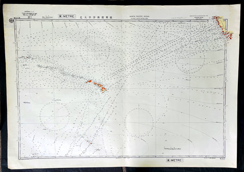
1939 Japanese Safety Agency Large Antique Map of Hawaii, Pacific - Pearl Harbor
- Title : North Pacific Ocean Southern Portion Eastern Sheet, Compiled from the United States and the British Charts to 1939
- Date : 1939
- Size: 43in x 30in (1.090m x 760mm)
- Condition: (A+) Fine Condition
- Ref: 27101
Description:
This original very large lithograph map, a sea chart, with depth soundings, of The Central Pacific, centering on the Hawaiian Islands was complied by the Maritime Safety Agency Japan (MSAJ) from American & British charts. The maps centers on the Hawaiian Islands east to California and south to the Christmas Islands.
The importance of this map cannot be overstated in the context of time and would have no doubt been used by the Japanese carrier group and their attack on Pearl Harbour in 1941.
General Definitions:
Paper thickness and quality: - Heavy and stable
Paper color : - off white
Age of map color: - Original
Colors used: - Blue
General color appearance: - Authentic
Paper size: - 43in x 30in (1.090m x 760mm)
Plate size: - 43in x 30in (1.090m x 760mm)
Margins: - Min 1in (25mm)
Imperfections:
Margins: - None
Plate area: - None
Verso: - None
Background:
The attack on Pearl Harbor was a surprise military strike by the Imperial Japanese Navy Air Service upon the United States against the U.S. naval base at Pearl Harbor in Honolulu, Hawaii, just before 8:00 a.m. (local time) on Sunday, December 7, 1941. The United States was a neutral country at the time; the attack led to its formal entry into World War II on the side of the Allies the next day. The Japanese military leadership referred to the attack as the Hawaii Operation and Operation AI, and as Operation Z during its planning.
The attack was preceded by months of negotiations between the U.S. and Japan over the future of the Pacific. Japanese demands included that the U.S. end its sanctions against Japan, cease aiding China in the Second Sino-Japanese war, and allow Japan to access the resources of the Dutch East Indies. Anticipating a negative response from the US, Japan sent out its naval attack groups in November 1941 just prior to receiving the Hull note—the U.S. demand that Japan withdraw from China and French Indochina.
Japan intended the attack as a preventive action. Its aim was to prevent the United States Pacific Fleet from interfering with its planned military actions in Southeast Asia against overseas territories of the United Kingdom, the Netherlands, and those of the United States. Over the course of seven hours there were coordinated Japanese attacks on the U.S.-held Philippines, Guam, and Wake Island and on the British Empire in Malaya, Singapore, and Hong Kong.
The attack commenced at 7:48 a.m. Hawaiian Time (6:18 p.m. GMT). The base was attacked by 353 Imperial Japanese aircraft (including fighters, level and dive bombers, and torpedo bombers) in two waves, launched from six aircraft carriers. Of the eight U.S. Navy battleships present, all were damaged, with four sunk. All but USS Arizona were later raised, and six were returned to service and went on to fight in the war. The Japanese also sank or damaged three cruisers, three destroyers, an anti-aircraft training ship, and one minelayer. More than 180 US aircraft were destroyed. A total of 2,403 Americans were killed and 1,178 others were wounded, making it the deadliest event ever recorded in Hawaii. Important base installations such as the power station, dry dock, shipyard, maintenance, and fuel and torpedo storage facilities, as well as the submarine piers and headquarters building (also home of the intelligence section) were not attacked. Japanese losses were light: 29 aircraft and five midget submarines lost, and 64 servicemen killed. Kazuo Sakamaki, the commanding officer of one of the submarines, was captured.
Japan announced declarations of war on the United States and the British Empire later that day (December 8 in Tokyo), but the declarations were not delivered until the following day. The British government declared war on Japan immediately after learning that their territory had also been attacked, while the following day (December 8) the United States Congress declared war on Japan. On December 11, though they had no formal obligation to do so under the Tripartite Pact with Japan, Germany and Italy each declared war on the U.S., which responded with a declaration of war against Germany and Italy. There were numerous historical precedents for the unannounced military action by Japan, but the lack of any formal warning (required by part III of the Hague Convention of 1907), particularly while negotiations were still apparently ongoing, led President Franklin D. Roosevelt to proclaim December 7, 1941, a date which will live in infamy. Because the attack happened without a declaration of war and without explicit warning, the attack on Pearl Harbor was later judged in the Tokyo Trials to be a war crime.