Maps (6)

1662 Joan Blaeu Complete Set of 9 Antique Maps of North America from Atlas Major, 1st Edition
- Titles:
1. Extrema Americae....Terra Nova Francia;
2. Nova Belgica Et Anglia Nova;
3. Nova Virginiae Tabula;
4. Virginiae partis australis, et Floridae;
5. Nova Hispania;
6. Yucatan...Guatimala;
7. Insulae Americanae;
8. Canibales Insulae;
9. Mappa Aestivarum Insularum Alias Barmudas - Sizes: 24in x 20 1/2in (610mm x 520mm)ea
- Condition: (A+) Fine Condition
- Date: 1662
- Ref #: BlaeuNA 1662
Description:
This is a unique opportunity to acquire a complete set of 9 maps of North America published by Joan Blaeus in the monumental & rare 1st 1662 Latin edition of Atlas Major. The maps cover the geographical detail of Canada, North America, Mexico, The Caribbean & Central America. Please see the background section below for details of each map. All maps have wide original margins & colour on strong sturdy paper.
Joan Blaeus 11 volumes of Atlas Major, is considered by many to be the greatest atlas set ever published. It excels in comprehensiveness, engraving, color, and overall production. The first edition was published in Latin in 1662 and was subsequently published in French, Dutch, German, and Spanish over the next 10 years.
On the 23rd of February 1672, a fire broke out in central Amsterdam, that ended the reign of one of the greatest & most prolific publishers of printed maps and atlases in publishing history. The Blaeu family had reached its zenith 10 years previously, with the publication of its greatest achievement, the Atlas Major or Great Atlas, consisting of 11 volumes, with geographical detail reflecting many of the achievements of the Golden Age of the United Netherlands. Blaeus Atlas Major were the most expensive books printed in the 17th century.
General Definitions:
Paper thickness and quality: - Heavy and stable
Paper color : - off white
Age of map color: - Original
Colors used: - Blue, pink, red, green, yellow
General color appearance: - Authentic
Paper size: - 24in x 20 1/2in (610mm x 520mm)
Plate size: - Various, pls see below
Margins: - Min 1in (25mm) min
Imperfections:
Margins: - Pls see below
Plate area: - Pls see below
Verso: - Pls see below
Background:
1. Extrema Americae ( Eastern Canada) - Rare only published in Atlas Major. Derived mainly from the Samuel de Champlain Nouvelle France map of 1632, this map reflects the growing financial importance of the waters of New France to Europe.
Plate: 22 1/2in x 17 3/4in.
Condition: Age toning, text show-through & browning to image.
2. Nova Belgica Et Anglia Nova (New England) - NE America, centering on New York and Manhattan from Virginia to the St Lawrence River. This map is noted for the fact that its primary source is the first manuscript figurative map of Adriaen Block from 1614. Indeed it is the first full representation of it in print. It is one of the earliest to name Nieu Amsterdam. Block, a Dutch fur trader, explored the area between Cape Cod and Manhattan, examining the bays and rivers along the way.
Plate: 19 1/2in x 15 1/2in
Condition: Age toning, text show-through & browning to image.
3. Nova Virginiae Tabula (John Smiths Virginia & Chesapeake Bay) This map was printed from a plate engraved by Dirk Grijp from a previous plates by Henricus Hondius.
Plate: 19in x 15in
Condition: Light age toning
4. Virginiae partis australis, et Floridae Virginia, the Carolinas & Georgia.
Plate: 20in x 15in
Condition: Light age toning
5. Nova Hispania et Nova Galicia Western Mexico
Plate: 19 1/2in x 15 1/2in
Condition: Light age toning
6. Yucatan...Guatimala (Yucatan, Central America) Rare only published in Atlas Major.
Plate: 20 1/2in x 16 1/2in
Condition: Light age toning
7. Insulae Americana (GOM, Caribbean)
Plate: 20 1/2in x 15in
Condition: Light age toning
8. Canibales Insulae (Lesser Antilles Islands) Rare, printed only in Atlas Major
Plate: 21in x 16 1/2in
Condition: Age toning
9. Mappa Aestivarum Insularum Alias Barmudas Dictarum Bermuda. Like all 17th century maps of Bermuda this map is based ultimately on the survey made by John Norwood, of the Bermuda Company, in 1618 in the form as published by the English map-maker John Speed in 1627.
Plate: 21in x 16in
Condition: Light age toning
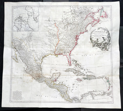
1746 J B D Anville Large Rare Antique Map of North America Pre French Indian War
-
Title : Amerique Septentrionale Publiee sous les Auspices de Monseigneur le Duc d Orleans.. Par Le Snr. D Anville MDCCXLVI
- Ref #: 17010
-
Condition: (A+) Fine Condition
- Size: 42 1/2in x 37in (1.08m x 940mm)
- Date : 1746
Description:
This large important original copper plate engraved antique map of North America, in 12 sheets joined, was engraved in 1746 - dated in the cartouche - and was published by Jean-Baptiste Bourguinon D Anville in his Elephant Folio Atlas Generale.
This map was instrumental in instructing the European Colonial powers of the time, England France & Spain the importance of dominating the New World, that ultimately led to the French and Indian War of 1754–63. This conflict determined the political direction of North America leading to the American War of Independence in 1775 and ultimately the formation of The United States of America.
To illustrate the importance of cartography in the mid eighteenth century, especially that of North America, a J B D Anville map is essential. D Anville dominated 18th century European cartography with many of his cartographical achievements, especially in North America, copied by many of his contemporaries such as Kitchen, Sayer, Homann, Seutter, Mitchell and others .
He was one of the first to leave blank spaces in his maps, where knowledge was scant or insufficient. His representation of the great lakes is superior to that of his contemporary John Mitchell, responsible for publishing one of the most famous mid 18th century maps of North America, A Map of the British and French Dominions in North America on 8 sheets in 1755 and remained the standard map of North America up until the end of the 18th century. (Ref: Tooley, Printed maps of America, 104; The Mapping of America 316)
General Definitions:
Paper thickness and quality: - Heavy and stable
Paper color : - off white
Age of map color: - Original
Colors used: - Red, yellow, green, blue
General color appearance: - Authentic
Paper size: - 42 1/2in x 37in (1.08m x 940mm)
Plate size: - 34 1/2in x 33 1/2in (875m x 850mm)
Margins: - Min 1in (25mm)
Imperfections:
Margins: - Small wormholes in left margin repaired, not affecting the image
Plate area: - Light age toning
Verso: - Age toning
Background:
The French and Indian War (1754–63) comprised the North American theatre of the worldwide Seven Years War of 1756–63. It pitted the colonies of British America against those of New France. Both sides were supported by military units from their parent countries, as well as by American Indian allies. At the start of the war, the French North American colonies had a population of roughly 60,000 settlers, compared with 2 million in the British North American colonies. The outnumbered French particularly depended on the Indians. The European nations declared war on one another in 1756 following months of localized conflict, escalating the war from a regional affair into an intercontinental conflict.
The name French and Indian War is used mainly in the United States. It refers to the two enemies of the British colonists, the royal French forces and their various American Indian allies. The British colonists were supported at various times by the Iroquois, Catawba, and Cherokee, and the French colonists were supported by Wabanaki Confederacy members Abenaki and Mikmaq, and Algonquin, Lenape, Ojibwa, Ottawa, Shawnee, and Wyandot.
British and other European historians use the term the Seven Years War, as do English-speaking Canadians. French Canadians call it La guerre de la Conquête (the War of the Conquest) or (rarely) the Fourth Intercolonial War.
Fighting took place primarily along the frontiers between New France and the British colonies, from Virginia in the south to Newfoundland in the north. It began with a dispute over control of the confluence of the Allegheny River and Monongahela River called the Forks of the Ohio, and the site of the French Fort Duquesne in Pittsburgh, Pennsylvania. The dispute erupted into violence in the Battle of Jumonville Glen in May 1754, during which Virginia militiamen under the command of 22-year-old George Washington ambushed a French patrol.
In 1755, six colonial governors in North America met with General Edward Braddock, the newly arrived British Army commander, and planned a four-way attack on the French. None succeeded, and the main effort by Braddock proved a disaster; he lost the Battle of the Monongahela on July 9, 1755 and died a few days later. British operations failed in the frontier areas of Pennsylvania and New York during 1755–57 due to a combination of poor management, internal divisions, effective Canadian scouts, French regular forces, and Indian warrior allies. In 1755, the British captured Fort Beauséjour on the border separating Nova Scotia from Acadia, and they ordered the expulsion of the Acadians (1755–64) soon afterwards. Orders for the deportation were given by William Shirley, Commander-in-Chief, North America, without direction from Great Britain. The Acadians were expelled, both those captured in arms and those who had sworn the loyalty oath to His Britannic Majesty. Indians likewise were driven off the land to make way for settlers from New England.
The British colonial government fell in the region of modern Nova Scotia after several disastrous campaigns in 1757, including a failed expedition against Louisbourg and the Siege of Fort William Henry; this last was followed by Indians torturing and massacring their British victims. William Pitt came to power and significantly increased British military resources in the colonies at a time when France was unwilling to risk large convoys to aid the limited forces that they had in New France, preferring to concentrate their forces against Prussia and its allies in the European theater of the war. Between 1758 and 1760, the British military launched a campaign to capture the Colony of Canada (part of New France). They succeeded in capturing territory in surrounding colonies and ultimately the city of Quebec (1759). The British later lost the Battle of Sainte-Foy west of Quebec (1760), but the French ceded Canada in accordance with the Treaty of Paris (1763).
The outcome was one of the most significant developments in a century of Anglo-French conflict. France ceded to Great Britain its territory east of the Mississippi. It ceded French Louisiana west of the Mississippi River (including New Orleans) to its ally Spain in compensation for Spains loss to Britain of Florida. (Spain had ceded Florida to Britain in exchange for the return of Havana, Cuba.) Frances colonial presence north of the Caribbean was reduced to the islands of Saint Pierre and Miquelon, confirming Great Britains position as the dominant colonial power in eastern North America.
Please note all items auctioned are genuine, we do not sell reproductions. A Certificate of Authenticity (COA) can be issued on request.
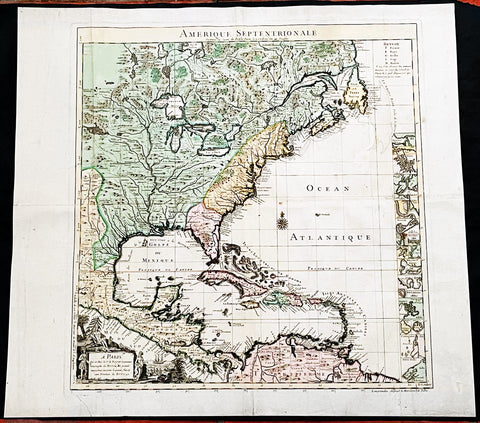
1742 Henry Popple & George Le Rouge Large Antique Map of Colonial America
- Title : Amerique Septentrionale Suivant la Carte de Pople....A Paris....Le Rouge...1742
- Date : 16742
- Size: 24 1/2in x 22 1/2in (625mm x 570mm)
- Condition: (A) Very Good Condition
- Ref: 27093
Description:
This incredibly important, original hand coloured copper plate engraved antique map of North America by George Le Rouge, after Henry Popples famous North America map, was published in 1742 - dated.
A handsome key sheet from a French edition of the first large-scale map of colonial North America. Among the 18 inset maps along the right border are ones of Bermuda, Boston, New York City, and Charleston. Popple's original, 1733 map ran to 20 sheets, hence the necessity of a key sheet. It was a semi-official undertaking intended to depict for British colonial administrators the respective North American territories of England, France and Spain. This French-published version, as expected, greatly exaggerates French territory at the expense of both England and Spain.
General Definitions:
Paper thickness and quality: - Heavy and stable
Paper color : - off white
Age of map color: - Original & later
Colors used: - Yellow, green, blue, pink
General color appearance: - Authentic
Paper size: - 24 1/2in x 22 1/2in (625mm x 570mm)
Plate size: - 20 3/4in x 19 3/4in (525mm x 500mm)
Margins: - Min 1in (30mm)
Imperfections:
Margins: - Light creasing along margins
Plate area: - Light creasing
Verso: - Re-enforced along centerfold
Background:
In 1730, the English Board of Trade & Plantations issued a request for maps of the British, French, and Spanish territorial claims in the New World, as ongoing boundary conflicts hindered economic development in the colonies. A former employee, Henry Popple, created an incredible 20-sheet map first published in 1733 that covered a broad region between Hudson Bay and the northern coast of South America and inland as far as the Rio Grande. It would become tremendously influential diplomatically as disputes among European powers increased dramatically in subsequent decades.
Accompanying the monumental production was a keymap, seen here as a later French edition issued by Georges Louis Le Rouge in 1742. With the exception of the language, decorative elements, annotations, and a missing vignette in the upper left corner, the image is largely the same as the original. It’s surprisingly accurate, as Popple was studious in his use of the latest available sources, though several geographic features have been enlarged or distorted and a large mysterious lake filled with islands appears near the western edge of the sheet.
It’s likely this is a remnant of the great saline sea speculated by Baron Lahontan, a French military officer who traveled extensively throughout the Great Lakes region from 1684 -1689. He later wrote several popular travel volumes that included reports of a Long (or Longue) River that branched from the Missippi westward, eventually reaching a large salt lake at the foot of a mountain range. The geographic influences of his story would be reflected in subsequent cartographic efforts throughout the 18th and into the early 19th century, and speculation on Lahontan’s travels persists to this day.
Elsewhere in the image, the topography is depicted pictorially and shows a prominent Appalachian Mountain range as well as a curious plateau in Michigan that Lewis Karpinski describes as a “fanciful creation.” Native American and European settlements are identified throughout and geographic features are labeled according to the key in the upper right. Seventeen inset plans of prominent port cities and islands can be seen in the lower right; including Boston, Charleston, New York, St. Augustine, Havana, and Cartagena.
Popple, Henry 1680 - 1743
Henry Popple was a British cartographer active in the early part of the 18th century. Popple was a clerk with the Board of Trade and Plantations, the organization that governed Britain's colonies in America. With his father, grandfather, and brother all being employed the board of trade, the Popple family had a long history of association with the British colonial administration. Popple received his commission as a clerk at the board of trade in 1727, but resigned in the same year. Curiously this is the same year he began work on his signature production, the Popple of North America, he resigned from the board to take a position as the Cashier to Queen Anne. Nonetheless he continued to work on his great maps and a manuscript version of the Popple Map appeared in this very year. Subsequently, Popple continued to update and refine the map until 1733 when it was finally printed. The Board of trade intended the Popple map to be a British response to Delisle's French mapping of North America, which presented boundaries that conflicted with British colonial ambitions. However, since Popple in fact based much of his map on Delisle's superior cartography, he also managed to copy many of the French political boundaries - to the detriment of the Board of Trade and its expansionist intentions. Although Popple's map was never approved by the Board, examples were rushed to each colonial governor and the map played a significant role in the cartographic history of North America. Popple cartographic endeavor began and ended with this singular map however, it significance was such that he must be considered in any list of significant British mapmakers.
George Louis Le Rouge fl. 1740-80
A military engineer by profession, le Rouge took up cartography and over a long period from about 1740 to 1780 produced many attractive works covering a wide range of subjects including plans of fortifications, military campaigns, town plans as well as the more usual atlases and sea charts.
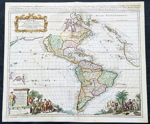
1695 Gerard Valk Antique Map of North & South America, California as an Island
- Title : L'Amerique Septentrionale & Meridionale divisee en ses principales parties
- Ref #: 35624
- Condition: (B) Good Condition
- Size: 24 1/4in x 20 3/4in (615mm x 530mm)
- Date: 1695
Description:
This original, copper plate engraved scarce antique map of the Americas, showing California as an Island, was published in the last decade of the 18th century in ca 1695.
This map is relatively rare as it was not included in any standard atlas but was optional, allowing the buyer to choose this along with other engraved map, to include in a bespoke atlas.
This map has undergone some professional restoration, it is complete and has been re-enforced in places on the verso along existing creases to the left and right side center of the map (please see images) as well as re-enforcement along centerfold and corners. Please see images and description below. Priced with condition in mind.
General Definitions:
Paper thickness and quality: - Light and stable
Paper color : - White
Age of map color: - Original & later
Colors used: - Yellow, green, blue, pink
General color appearance: - Authentic
Paper size: - 24 1/4in x 20 3/4in (615mm x 530mm)
Plate size: - 23in x 19 3/4in (590mm x 505mm)
Margins: - Min 1/2in (12mm)
Imperfections:
Margins: - Top right & bottom left corners of margins restored, age toning, several small repairs to margins not affecting the images
Plate area: - Creasing to image, centerfold re-joined
Verso: - Old creasing re-enforced with archival tape to verso, creasing, age toning
Background:
Scarce map of America, published in Amsterdam by Gerard Valk. Valk's map of California shows many of the most fascinating myths of the 17th Century. California is shown as an island on the so-called "second Sanson Model." A massive land bridge extends from just west of Capo Blanco on the northern California coastline to Niphon, a curious adaptation of the legend of Compagnie Land (shown here as a place name -- Terre de la Compagne) and the continuous land bridge from America to Asia, although adding the Detroit de Tzungaar (Strait of Tzungaar), a very rarely mentioned mythical Strait between two islands of Japan.
The Great Lakes are oddly configured, with Lake Superior and Lake Michigan open ended to the West. The Mississippi River is very ill conceived, pre-dating the radical improvements which would come with Guilluame De L'Isle's map of North America of 1700 and Carte du Mexique of 1703.
The fine allegorical cartouches depict the booming trade then being conducted by Europeans in the New World.
Valk, Gerard 1651 - 1726
Gerard Valk was a prominent Dutch engraver, publisher, and art dealer during the late 17th and early 18th centuries. He is best known for his contributions to the field of cartography and his collaborations with renowned artists and mapmakers of his time.
Valk was born on April 6, 1651, in Amsterdam, the Netherlands. Little is known about his early life and education, but it is believed that he received training as an engraver, possibly under the tutelage of his father, Balthasar Valk, who was also an engraver and publisher.
In the late 1670s, Gerard Valk established his own publishing firm in Amsterdam, specializing in the production of maps, atlases, and prints. He quickly gained recognition for his skill as an engraver and his ability to produce high-quality, detailed maps. Valk's maps were often based on the work of renowned cartographers of the time, such as Frederik de Wit and Nicolaes Visscher, whose plates he acquired and reprinted.
Valk's maps covered a wide range of geographical regions, including Europe, Asia, Africa, and the Americas. His maps were meticulously crafted, featuring elaborate cartouches, decorative elements, and accurate geographic information. He also collaborated with notable artists and engravers, such as Jan Luyken and Romeyn de Hooghe, who provided illustrations and embellishments for his publications.
Apart from cartography, Valk also published and sold prints of various subjects, including portraits, landscapes, historical scenes, and genre paintings. He catered to a diverse clientele, ranging from collectors and scholars to wealthy individuals and institutions.
Valk's publishing business flourished, and he enjoyed considerable success and acclaim during his lifetime. His maps and prints were highly sought after for their quality and accuracy. He maintained a strong network of contacts throughout Europe, including fellow publishers, mapmakers, and merchants, which allowed him to expand his business and reach a wider market.
Gerard Valk passed away on August 26, 1726, in Amsterdam, leaving behind a legacy as a skilled engraver, publisher, and contributor to the development of cartography. His work played a significant role in disseminating geographical knowledge and capturing the aesthetic beauty of maps during the late 17th and early 18th centuries. Today, Valk's maps and prints are considered valuable collectors' items, cherished for their historical and artistic value.
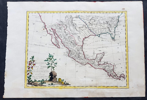
1785 Antonio Zatta Large Antique Map of Mexico, Texas, California, SW & SE USA
- Title : Messico ouvero Nuova Spagna che contiene Il Nuovo Messico La Californoa Con Una Partie de Paesi Adjacenti Venezi 1785
- Size: 21in x 15in (535mm x 385mm)
- Condition: (A+) Fine Condition
- Date : 1785
- Ref #: 93006
Description:
This large beautifully hand coloured original antique map of Mexico including Texas, California, and the SE USA was engraved in 1785 - the date is engraved in the title cartouche - and was published by Antonio Zatta in his Atlas Atlante Novissimo. (Ref: Tooley; M&B)
General Definitions:
Paper thickness and quality: - Heavy and stable
Paper color : - off white
Age of map color: - Original
Colors used: - Blue, pink, red, green, yellow
General color appearance: - Authentic
Paper size: - 21in x 15in (535mm x 385mm)
Plate size: - 16in x 12 1/2in (405mm x 320mm)
Margins: - Min 1in (25mm)
Imperfections:
Margins: - None
Plate area: - None
Verso: - Light age toning
Background:
The capture of Tenochtitlan and refounding of Mexico City in 1521 was the beginning of a 286-year-long colonial era during which Mexico was known as Nueva España (New Spain). The Kingdom of New Spain was created from the remnants of the Aztec hegemonic empire. Subsequent enlargements, such as the conquest of the Tarascan state, resulted in the creation of the Viceroyalty of New Spain in 1535. The Viceroyalty at its greatest extent included the territories of modern Mexico, Central America as far south as Costa Rica, and the western United States. The Viceregal capital Mexico City also administrated the Spanish West Indies (the Caribbean), the Spanish East Indies (the Philippines), and Spanish Florida.
The indigenous population stabilized around one to one and a half million individuals in the 17th century from the most commonly accepted five to ten million pre-contact population. The population decline was primarily the result of communicable diseases, particularly smallpox, introduced during the Columbian Exchange. During the three hundred years of the colonial era, Mexico received between 400,000 and 500,000 Europeans, between 200,000 and 250,000 Africans and between 40,000 and 120,000 Asians. The 18th century saw a great increase in the percentage of mestizos.
Colonial law with Spanish roots was introduced and attached to native customs creating a hierarchy between local jurisdiction (the Cabildos) and the Spanish Crown. Upper administrative offices were closed to native-born people, even those of pure Spanish blood (criollos). Administration was based on the racial separation, among Republics of Spaniards, Amerindians and castas, autonomous and directly dependent on the king himself.
The Council of Indies and the mendicant religious orders, which arrived in Mesoamerica as early as 1524, labored to generate capital for the crown of Spain and convert the Amerindian populations to Catholicism. The 1531 Marian apparitions to Saint Juan Diego gave impetus to the evangelization of central Mexico. The Virgin of Guadalupe became a symbol of criollo patriotism and was used by the insurgents that followed Miguel Hidalgo during the War of Independence. Some Crypto-Jewish families emigrated to Mexico to escape the Spanish Inquisition.
The rich deposits of silver, particularly in Zacatecas and Guanajuato, resulted in silver extraction dominating the economy of New Spain. Taxes on silver production became a major source of income for Spain. Other important industries were the haciendas (functioning under the encomienda and repartimiento systems) and mercantile activities in the main cities and ports. Wealth created during the colonial era spurred the development of New Spanish Baroque.
As a result of its trade links with Asia, the rest of the Americas, Africa and Europe and the profound effect of New World silver, central Mexico was one of the first regions to be incorporated into a globalized economy. Being at the crossroads of trade, people and cultures, Mexico City has been called the first world city. The Nao de China (Manila Galleons) operated for two and a half centuries and connected New Spain with Asia. Goods were taken from Veracruz to Atlantic ports in the Americas and Spain. Veracruz was also the main port of entry in mainland New Spain for European goods, immigrants, and African slaves. The Camino Real de Tierra Adentro connected Mexico City with the interior of New Spain. Mexican silver pesos became the first globally used currency and the silver mined in Mexico were used to run commerce and wage crusades in two sides of globe, at the Mediterranean were Spain fought against the Ottoman Caliphate and at Southeast Asia where the Philippines fought against the Brunei Sultanate.
Due to the importance of New Spain administrative base, Mexico was the location of the first printing shop (1539), first university (1551), first public park (1592), and first public library (1646) in the Americas, amongst other institutions. Important artists of the colonial period, include the writers Juan Ruiz de Alarcón and Sor Juana Inés de la Cruz, painters Cristóbal de Villalpando and Miguel Cabrera, and architect Manuel Tolsá. The Academy of San Carlos was the first major school and museum of art in the Americas. Scientist Andrés Manuel del Río Fernández discovered the element vanadium.
Spanish forces, sometimes accompanied by native allies, led expeditions to conquer territory or quell rebellions through the colonial era. Notable Amerindian revolts in sporadically populated northern New Spain include the Chichimeca War (1576–1606), Tepehuán Revolt (1616–1620) and the Pueblo Revolt (1680). To protect Mexico from the attacks of English, French and Dutch pirates and protect the Crowns monopoly of revenue, only two ports were open to foreign trade—Veracruz on the Atlantic and Acapulco on the Pacific. Among the best-known pirate attacks are the 1663 Sack of Campeche and 1683 Attack on Veracruz.
Many Mexican cultural features including tequila, first distilled in the 16th century, charreria (17th), mariachi (18th) and Mexican cuisine, a fusion of American and European (particularly Spanish) cuisine, arose during the colonial era.
On September 16, 1810, a loyalist revolt against the ruling junta was declared by priest Miguel Hidalgo y Costilla, in the small town of Dolores, Guanajuato. This event, known as the Cry of Dolores (Spanish: Grito de Dolores) is commemorated each year, on September 16, as Mexicos independence day. The first insurgent group was formed by Hidalgo, the Spanish viceregal army captain Ignacio Allende, the militia captain Juan Aldama and La Corregidora Josefa Ortiz de Domínguez. Hidalgo and some of his soldiers were captured and executed by firing squad in Chihuahua, on July 31, 1811. Following his death, the leadership was assumed by priest José María Morelos, who occupied key southern cities.
In 1813 the Congress of Chilpancingo was convened and, on November 6, signed the Solemn Act of the Declaration of Independence of Northern America. Morelos was captured and executed on December 22, 1815.
In subsequent years, the insurgency was near collapse, but in 1820 Viceroy Juan Ruiz de Apodaca sent an army under the criollo general Agustín de Iturbide against the troops of Vicente Guerrero. Instead, Iturbide approached Guerrero to join forces, and on August 24, 1821 representatives of the Spanish Crown and Iturbide signed the Treaty of Córdoba and the Declaration of Independence of the Mexican Empire, which recognized the independence of Mexico under the terms of the Plan of Iguala.
Mexicos short recovery after the War of Independence was soon cut short again by the civil wars and institutional instability of the 1850s, which lasted until the government of Porfirio Díaz reestablished conditions that paved the way for economic growth. The conflicts that arose from the mid-1850s had a profound effect because they were widespread and made themselves perceptible in the vast rural areas of the countries, involved clashes between castes, different ethnic groups and haciendas, and entailed a deepening of the political and ideological divisions between republicans and monarchists.
Agustín de Iturbide became constitutional emperor of the First Mexican Empire in 1822. A revolt against him in 1823 established the United Mexican States. In 1824, a Republican Constitution was drafted and Guadalupe Victoria became the first president of the newly born country. Central America, including Chiapas, left the union. In 1829 president Guerrero abolished slavery. The first decades of the post-independence period were marked by economic instability, which led to the Pastry War in 1836. There was constant strife between Liberals, supporters of a federal form of government, and Conservatives, who proposed a hierarchical form of government.
During this period, the frontier borderlands to the north became quite isolated from the government in Mexico City, and its monopolistic economic policies caused suffering. With limited trade, the people had difficulty meeting tax payments and resented the central governments actions in collecting customs. Resentment built up from California to Texas. Both the mission system and the presidios had collapsed after the Spanish withdrew from the colony, causing great disruption especially in Alta California and New Mexico. The people in the borderlands had to raise local militias to protect themselves from hostile Native Americans. These areas developed in different directions from the center of the country.
Wanting to stabilize and develop the frontier, Mexico encouraged immigration into present-day Texas, as they were unable to persuade people from central Mexico to move into those areas. They allowed for religious freedom for the new settlers, who were primarily Protestant English speakers from the United States. Within several years, the Anglos far outnumbered the Tejano in the area. Itinerant traders traveled through the area, working by free market principles. The Tejano grew more separate from the government and due to its neglect, many supported the idea of independence and joined movements to that end, collaborating with the English-speaking Americans.
General Antonio López de Santa Anna, a centralist and two-time dictator, approved the Siete Leyes in 1836, a radical amendment that institutionalized the centralized form of government. When he suspended the 1824 Constitution, civil war spread across the country. Three new governments declared independence: the Republic of Texas, the Republic of the Rio Grande and the Republic of Yucatán.
The 1846 United States annexation of the Republic of Texas and subsequent American military incursion into territory that was part of Coahuila (also claimed by Texas) instigated the Mexican–American War. The war was settled in 1848 via the Treaty of Guadalupe Hidalgo. Mexico was forced to give up more than one-third of its land to the U.S., including Alta California, Santa Fe de Nuevo México and the territory claimed by Texas. A much smaller transfer of territory in what is today southern Arizona and southwestern New Mexico—known as the Gadsden Purchase—occurred in 1854.
The Caste War of Yucatán, the Maya uprising that began in 1847, was one of the most successful modern Native American revolts. Maya rebels, or Cruzob, maintained relatively independent enclaves in the peninsula until the 1930s.
Dissatisfaction with Santa Annas return to power led to the liberal Plan of Ayutla, initiating an era known as La Reforma. The new Constitution drafted in 1857 established a secular state, federalism as the form of government, and several freedoms. As the Conservatives refused to recognize it, the Reform War began in 1858, during which both groups had their own governments. The war ended in 1861 with victory by the Liberals, led by president Benito Juárez, who was an ethnic Zapotec.
In the 1860s Mexico was occupied by France, which established the Second Mexican Empire under the rule of the Habsburg Archduke Ferdinand Maximilian of Austria with support from the Roman Catholic clergy and the Conservatives. The latter switched sides and joined the Liberals. Maximilian surrendered, was tried on June 14, 1867, and was executed a few days later on June 19 in Querétaro.
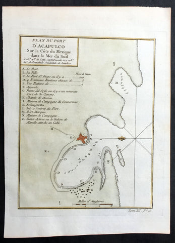
1752 Bellin Original Antique Map of Coastal City & Region of Acapulco, Mexico
- Title: Plan Du Port D Acapulco Sur la Cote du Mexique..
- Date: 1752
- Size: 10in x 7 1/4in (255mm x 185mm)
- Ref: 25804
- Condition : (A+) Fine Condition
Description:
This fine, original copper-plate engraved antique map of the Coastal city & region of Acapulco, Mexico - with legend to various places of interest - by Jacques Nicolas Bellin in 1752 was published in Antoine François Prevosts 15 volumes of Histoire Generale des Voyages written by Prevost & other authors between 1746-1790.
Acapulco de Juárez commonly called Acapulco, is a city, municipality and major seaport in the state of Guerrero on the Pacific coast of Mexico, 380 kilometres (240 mi) south of Mexico City. Acapulco is located on a deep, semicircular bay and has been a port since the early colonial period of Mexico\'s history.
There are two stories about how Acapulco bay was discovered by Europeans. The first states that two years after the Spanish conquest of the Aztec Empire, Hernán Cortés sent explorers west to find gold. The explorers had subdued this area after 1523, and Captain Saavedra Cerón was authorized by Cortés to found a settlement here. The other states that the bay was discovered on December 13, 1526 by a small ship named the El Tepache Santiago captained by Santiago Guevara. The first encomendero was established in 1525 at Cacahuatepec, which is part of the modern Acapulco municipality. In 1531, a number of Spaniards, most notably Juan Rodriguez de Villafuerte, left the Oaxaca coast and founded the village of Villafuerte where the city of Acapulco now stands. Villafuerte was unable to subdue the local native peoples, and this eventually resulted in the Yopa Rebellion in the region of Cuautepec. Hernán Cortés was obligated to send Vasco Porcayo to negotiate with the indigenous people giving concessions. The province of Acapulco became the encomendero of Rodriguez de Villafuerte who received taxes in the form of cocoa, cotton and corn
Cortés established Acapulco as a major port by the early 1530s, with the first major road between Mexico City and the port constructed by 1531. The wharf, named Marqués, was constructed by 1533 between Bruja Point and Diamond Point. Soon after, the area was made an \"alcadia\" (major province or town).
Spanish trade in the Far East would give Acapulco a prominent position in the economy of New Spain. Galleons started arriving here from Asia by 1550, and in that year thirty Spanish families were sent to live here from Mexico City to have a permanent base of European residents. Acapulco would become the second most important port, after Veracruz, due to its direct trade with the Philippines. This trade would focus on the yearly Manila-Acapulco Galleon trade, which was the nexus of all kinds of communications between New Spain, Europe and Asia. In 1573, the port was granted the monopoly of the Manila trade
The galleon trade made its yearly run from the mid-16th century until the early 19th. The luxury items it brought to New Spain attracted the attention of English and Dutch pirates, such as Francis Drake, Henry Morgan and Thomas Cavendish, who called it \"The Black Ship.\" A Dutch fleet invaded Acapulco in 1615, destroying much of the town before being driven off. The Fort of San Diego was built the following year to protect the port and the cargo of arriving ships. The fort was destroyed by an earthquake in 1776 and was rebuilt between 1778 and 1783. At the beginning of the 19th century, King Charles IV declared Acapulco a Ciudad Official and it became an essential part of the Spanish Crown. However, not long after, the Mexican War of Independence began. In 1810, José María Morelos y Pavón attacked and burnt down the city, after he defeated royalist commander Francisco Parés at the Battle of Tres Palos. The independence of Mexico in 1821 ended the run of the Manila Galleon. Acapulco\'s importance as a port recovered during the California Gold Rush in the mid-19th-century, with ships going to and coming from Panama stopping here. This city was the besieged on 19 April 1854 by Antonio López de Santa Anna after Guerrero\'s leadership had rebelled by issuing the Plan de Ayutla. After an unsuccessful week of fighting, Santa Anna retreated.
General Definitions:
Paper thickness and quality: - Heavy and stable
Paper color : - off white
Age of map color: - Early
Colors used: - Green, Yellow,
General color appearance: - Authentic
Paper size: - 10in x 7 1/2in (255m x 190mm)
Plate size: - 8n x 6in (205mm x 155mm)
Margins: - Min 1/2in (12mm)
Imperfections:
Margins: - None
Plate area: - None
Verso: - None
Background:
One of Antoine Francois Prevosts monumental undertakings was his history of exploration & discovery in 15 volumes titledHistoire Générale des Voyages written between 1746-1759 and was extended to 20 volumes after his death by various authors.
The 20 volumes cover the early explorations & discoveries on 3 continents: Africa (v. 1-5), Asia (v. 5-11), and America (v. 12-15) with material on the finding of the French, English, Dutch, and Portugese.
A number of notable cartographers and engravers contributed to the copper plate maps and views to the 20 volumes including Nicolas Bellin, Jan Schley, Chedel, Franc Aveline, Fessard, and many others.
The African volumes cover primarily coastal countries of West, Southern, and Eastern Africa, plus the Congo, Madagascar, Arabia and the Persian Gulf areas.
The Asian volumes cover China, Korea, Tibet, Japan, Philippines, and countries bordering the Indian Ocean.
Volume 11 includes Australia and Antarctica.
Volumes 12-15 cover voyages and discoveries in America, including the East Indies, South, Central and North America.
Volumes 16-20 include supplement volumes & tables along with continuation of voyages and discoveries in Russia, Northern Europe, America, Asia & Australia.