Maps (60)
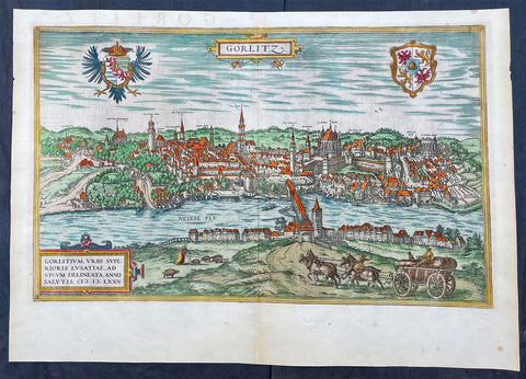
1574 Braun & Hogenberg Antique Map View of Gorlitz-Zgorzelec, Germany & Poland
- Title : Gorlitz
- Ref #: 93432
- Size: 22in x 16 1/2in (560mm x 420mm)
- Date : 1574
- Condition: (A+) Fine Condition
Description:
This original beautifully hand coloured copper plate engraved antique map, a birds eye view of the city of Gorlitz-Zgorzelec, in the state of Saxony, in the region of Lusatia, in far eastern Germany, on the border with Poland, was published in the 1574 edition of Braun & Hogenbergs atlas Civitates Orbis Terrarum
General Definitions:
Paper thickness and quality: - Heavy and stable
Paper color : - off white
Age of map color: - Original
Colors used: - Yellow, green, blue, pink
General color appearance: - Authentic
Paper size: - 22in x 16 1/2in (560mm x 420mm)
Plate size: - 20in x 12 1/2in (510mm x 320mm)
Margins: - Min 1in (25mm)
Imperfections:
Margins: - None
Plate area: - None
Verso: - None
Background:
As a small Sorbian village named Gorelic in the Margraviate of Meissen, a frontier march of the Holy Roman Empire, Gorlitz was temporarily conquered and held by the Kingdom of Poland during Bolesław I Chrobrys invasion of Lusatia between 1002 and 1031, after which the region fell back to the Margraviate of Meissen. In 1075, the village was assigned to the Duchy of Bohemia. The date of the towns foundation is unknown. However, Goreliz was first mentioned in a document from the King of Germany, and later Holy Roman Emperor, Henry IV in 1071. This document granted Gorlitz to the Diocese of Meissen, then under Bishop Benno of Meissen. Currently, this document can be found in the Saxony State Archives in Dresden.[3] The origin of the name Gorlitz is derived from the Slavic word for burned land,[4] referring to the technique used to clear land for settlement. Zgorzelec and Czech Zhořelec have the same derivation. In the 13th century the village gradually became a town. Due to its location on the Via Regia, an ancient and medieval trade route, the settlement prospered.
In the following centuries Gorlitz was a wealthy member of the Lusatian League, which consisted of Bautzen, Gorlitz, Kamenz, Lauban, Löbau and Zittau. In 1352 during the reign of Casimir the Great, Lusatian German colonists from Gorlitz founded the town of Gorlice in southern Poland near Kraków.
The Protestant Reformation came to Gorlitz in the early 1520s and by the last half of the 16th century, it and the surrounding vicinity, became almost completely Lutheran.
After suffering for years in the Thirty Years War, the region of Upper Lusatia (including Gorlitz) was ceded to the Electorate of Saxony in 1635. After the Napoleonic Wars, the 1815 Congress of Vienna transferred the town from the Kingdom of Saxony to the Kingdom of Prussia. Gorlitz was subsequently administered within the Province of Silesia, and, after World War I, the Province of Lower Silesia, until 1945.
From 1815 until 1918, Gorlitz belonged to the Province of Silesia in the Kingdom of Prussia, and later to the Province of Lower Silesia in the Free State of Prussia. It is the largest town of the former Province of Lower Silesia that lies west of the Oder-Neisse line and hence remained in Germany after World War II. Today, Gorlitz lies opposite the Polish town of Zgorzelec, which was part of Gorlitz until 1945. Together they form the German-Polish Euro City of Gorlitz-Zgorzelec.
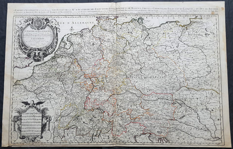
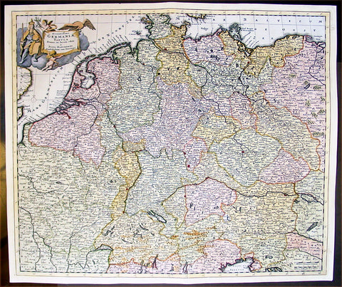
1692 Jaillot Large Antique Map of Allemagne or German Empire, Central Europe
- Title : L Empire D Allemagne distingue suivant l´etenedu de tous les estates principautes et souverainites...A Paris Chez...H Jaillot....1692
- Size: 37in x 24in (940mm x 615mm)
- Condition: (A+) Fine Condition
- Date : 1692
- Ref #: 16382
Description:
This very large, hand coloured original antique map of the German Empire and central Europe in the late 17th century by Alexis Hubert Jaillot - after Nicolas Sanson - was engraved in 1692 - the date is engraved in the dedication cartouche.
General Definitions:
Paper thickness and quality: - Heavy and stable
Paper color : - off white
Age of map color: - Original
Colors used: - Yellow, green, blue, pink
General color appearance: - Authentic
Paper size: - 37in x 24in (940mm x 615mm)
Plate size: - 36in x 23in (930mm x 605mm)
Margins: - Min 1/2in (12mm)
Imperfections:
Margins: - None
Plate area: - None
Verso: - None
Background:
The name Allemagne for Germany and the other similar-sounding names above are derived from the southern Germanic Alemanni, a Suebic tribe or confederation in todays Alsace, parts of Baden-Württemberg and Switzerland.
In 800, the Frankish king Charlemagne was crowned emperor and founded the Carolingian Empire, which was later divided in 843 among his heirs. Following the break up of the Frankish Realm, for 900 years, the history of Germany was intertwined with the history of the Holy Roman Empire, which subsequently emerged from the eastern portion of Charlemagnes original empire. The territory initially known as East Francia stretched from the Rhine in the west to the Elbe River in the east and from the North Sea to the Alps. The Ottonian rulers (919–1024) consolidated several major duchies and the German king Otto I was crowned Holy Roman Emperor of these regions in 962. In 996 Gregory V became the first German Pope, appointed by his cousin Otto III, whom he shortly after crowned Holy Roman Emperor. The Holy Roman Empire absorbed northern Italy and Burgundy under the reign of the Salian emperors (1024–1125), although the emperors lost power through the Investiture controversy.
In the 12th century, under the Hohenstaufen emperors (1138–1254), German princes increased their influence further south and east into territories inhabited by Slavs; they encouraged German settlement in these areas, called the eastern settlement movement (Ostsiedlung). Members of the Hanseatic League, which included mostly north German cities and towns, prospered in the expansion of trade. In the south, the Greater Ravensburg Trade Corporation (Große Ravensburger Handelsgesellschaft) served a similar function. The edict of the Golden Bull issued in 1356 by Emperor Charles IV provided the basic constitutional structure of the Empire and codified the election of the emperor by seven prince-electors who ruled some of the most powerful principalities and archbishoprics.
Population declined in the first half of the 14th century, starting with the Great Famine in 1315, followed by the Black Death of 1348–50. Despite the decline, however, German artists, engineers, and scientists developed a wide array of techniques similar to those used by the Italian artists and designers of the time who flourished in such merchant city-states as Venice, Florence and Genoa. Artistic and cultural centres throughout the German states produced such artists as the Augsburg painters Hans Holbein and his son, and Albrecht Dürer. Johannes Gutenberg introduced moveable-type printing to Europe, a development that laid the basis for the spread of learning to the masses.
In 1517, the Wittenberg priest Martin Luther nailed the Ninety-Five Theses to the church door, challenging the practice of selling of indulgences. He was subsequently excommunicated in the papal bull Exsurge Domine in 1520, and his followers were condemned in the 1521 Diet of Worms, which divided Western Christianity. In 1555, the Peace of Augsburg tolerated the Evangelical faith (now called Lutheranism) as an acceptable alternative to Catholicism, but also decreed that the faith of the prince was to be the faith of his subjects, a principle called cuius regio, eius religio. The agreement at Augsburg failed to address other religious creed: for example, the Reformed faith was still considered a heresy and the principle did not address the possible conversion of an ecclesiastic ruler, such as happened in Electorate of Cologne in 1583. However, in practice Calvinists were given protection under the Augsburg Confession Variata modified upon request by Philip Melanchthon.
From the Cologne War until the end of the Thirty Years Wars (1618–1648), religious conflict devastated German lands. The latter reduced the overall population of the German states by about 30 per cent, and in some places, up to 80 per cent. The Peace of Westphalia ended religious warfare among the Imperial Estates of the Holy Roman Empire. Their mostly German-speaking rulers were able to choose either Roman Catholicism, Lutheranism, or the Reformed faith as their official religion after 1648.
In the 18th century, the Holy Roman Empire consisted of approximately 1,800 territories. The elaborate legal system initiated by a series of Imperial Reforms (approximately 1450–1555) created the Imperial Estates and provided for considerable local autonomy among ecclesiastical, secular, and hereditary states, reflected in the Imperial Diet. The House of Habsburg held the imperial crown from 1438 until the death of Charles VI in 1740. Having no male heirs, he had convinced the Electors to retain Habsburg hegemony in the office of the emperor by agreeing to the Pragmatic Sanction of 1713. This was finally settled through the War of Austrian Succession; in the Treaty of Aix-la-Chapelle, Charles VIs daughter Maria Theresa ruled the Empire as Empress Consort when her husband, Francis I, became Holy Roman Emperor. From 1740, the dualism between the Austrian Habsburg Monarchy and the Kingdom of Prussia dominated the German history.
In 1772, then again in 1793 and 1795, the two dominant German states of Prussia and Austria, along with the Russian Empire, agreed to the Partitions of Poland; dividing among themselves the lands of the Polish–Lithuanian Commonwealth. As a result of the partitions, millions of Polish speaking inhabitants fell under the rule of the two German monarchies. However, the annexed territories though incorporated into the Kingdom of Prussia and the Habsburg Realm, were not legally considered as a part of the Holy Roman Empire. During the period of the French Revolutionary Wars, along with the arrival of the Napoleonic era and the subsequent final meeting of the Imperial Diet, most of the secular Free Imperial Cities were annexed by dynastic territories; the ecclesiastical territories were secularised and annexed. In 1806 the Imperium was dissolved; many German states, particularly the Rhineland states, fell under the influence of France. Until 1815, France, Russia, Prussia and the Habsburgs (Austria) competed for hegemony in the German states during the Napoleonic Wars.
Following the fall of Napoleon, the Congress of Vienna (convened in 1814) founded the German Confederation (Deutscher Bund), a loose league of 39 sovereign states. The appointment of the Emperor of Austria as the permanent president of the Confederation reflected the Congresss failure to accept Prussias rising influence among the German states, and acerbated the long-standing competition between the Hohenzollern and Habsburg interests. Disagreement within restoration politics partly led to the rise of liberal movements, followed by new measures of repression by Austrian statesman Metternich. The Zollverein, a tariff union, furthered economic unity in the German states.
National and liberal ideals of the French Revolution gained increasing support among many, especially young, Germans. The Hambach Festival in May 1832 was a main event in support of German unity, freedom and democracy. In the light of a series of revolutionary movements in Europe, which established a republic in France, intellectuals and commoners started the Revolutions of 1848 in the German states. King Frederick William IV of Prussia was offered the title of Emperor, but with a loss of power; he rejected the crown and the proposed constitution, leading to a temporary setback for the movement.
Foundation of the German Empire in Versailles, 1871. Bismarck is at the centre in a white uniform.
King William I appointed Otto von Bismarck as the new Minister President of Prussia in 1862. Bismarck successfully concluded war on Denmark in 1864, which promoted German over Danish interests in the Jutland peninsula. The subsequent (and decisive) Prussian victory in the Austro-Prussian War of 1866 enabled him to create the North German Confederation (Norddeutscher Bund) which excluded Austria from the federations affairs. After the French defeat in the Franco-Prussian War, the German princes proclaimed the founding of the German Empire in 1871 at Versailles, uniting all the scattered parts of Germany except Austria and the German-speaking parts of Switzerland. Prussia was the dominant constituent state of the new empire; the Hohenzollern King of Prussia ruled as its concurrent Emperor, and Berlin became its capital.

1710 John Senex Large Antique Map of Germany, Central Europe, Baltic to Austria
- Title : Germany Corrected from the Observations of the Royal Society at London and the Royal Academy at Paris by John Senex FRS....1710
- Size: 41in x 26 1/2in (1.040m x 660mm)
- Condition: (A) Very Good Condition
- Date : 1710
- Ref #: 24906
Description:
This large hand coloured original antique map of Germany was engraved by John Senex in 1710 - dated - and was published in Senex Elephant Folio Atlas.
This map is in VG condition, with these large scale maps being scarce due mainly to their size with damage and loss over time inevitable.
General Definitions:
Paper thickness and quality: - Heavy and stable
Paper color : - off white
Age of map color: - Original
Colors used: - Yellow, green, blue, pink
General color appearance: - Authentic
Paper size: - 41in x 26 1/2in (1.040m x 660mm)
Plate size: - 40in x 26in (1.00m x 650mm)
Margins: - Min 1/2in (12mm)
Imperfections:
Margins: - Chipping to bottom margin
Plate area: - Age toning along centerfold, light creasing
Verso: - Light creasing.
Background:
Because of Germanys long history as a non-united region of distinct tribes and states before January 1871, there are many widely varying names of Germany in different languages, perhaps more so than for any other European nation. For example, in the German language, the country is known as Deutschland, in Spanish as Alemania, in French as Allemagne, in Italian as Germania (although Germans are called tedeschi), in Polish as Niemcy, and in Finnish as Saksa.
In 800, the Frankish king Charlemagne was crowned emperor and founded the Carolingian Empire, which was later divided in 843 among his heirs. Following the break up of the Frankish Realm, for 900 years, the history of Germany was intertwined with the history of the Holy Roman Empire, which subsequently emerged from the eastern portion of Charlemagnes original empire. The territory initially known as East Francia stretched from the Rhine in the west to the Elbe River in the east and from the North Sea to the Alps. The Ottonian rulers (919–1024) consolidated several major duchies and the German king Otto I was crowned Holy Roman Emperor of these regions in 962. In 996 Gregory V became the first German Pope, appointed by his cousin Otto III, whom he shortly after crowned Holy Roman Emperor. The Holy Roman Empire absorbed northern Italy and Burgundy under the reign of the Salian emperors (1024–1125), although the emperors lost power through the Investiture controversy.
In the 12th century, under the Hohenstaufen emperors (1138–1254), German princes increased their influence further south and east into territories inhabited by Slavs; they encouraged German settlement in these areas, called the eastern settlement movement (Ostsiedlung). Members of the Hanseatic League, which included mostly north German cities and towns, prospered in the expansion of trade. In the south, the Greater Ravensburg Trade Corporation (Große Ravensburger Handelsgesellschaft) served a similar function. The edict of the Golden Bull issued in 1356 by Emperor Charles IV provided the basic constitutional structure of the Empire and codified the election of the emperor by seven prince-electors who ruled some of the most powerful principalities and archbishoprics.
Population declined in the first half of the 14th century, starting with the Great Famine in 1315, followed by the Black Death of 1348–50. Despite the decline, however, German artists, engineers, and scientists developed a wide array of techniques similar to those used by the Italian artists and designers of the time who flourished in such merchant city-states as Venice, Florence and Genoa. Artistic and cultural centres throughout the German states produced such artists as the Augsburg painters Hans Holbein and his son, and Albrecht Dürer. Johannes Gutenberg introduced moveable-type printing to Europe, a development that laid the basis for the spread of learning to the masses.
In 1517, the Wittenberg priest Martin Luther nailed the Ninety-Five Theses to the church door, challenging the practice of selling of indulgences. He was subsequently excommunicated in the papal bull Exsurge Domine in 1520, and his followers were condemned in the 1521 Diet of Worms, which divided Western Christianity. In 1555, the Peace of Augsburg tolerated the Evangelical faith (now called Lutheranism) as an acceptable alternative to Catholicism, but also decreed that the faith of the prince was to be the faith of his subjects, a principle called cuius regio, eius religio. The agreement at Augsburg failed to address other religious creed: for example, the Reformed faith was still considered a heresy and the principle did not address the possible conversion of an ecclesiastic ruler, such as happened in Electorate of Cologne in 1583. However, in practice Calvinists were given protection under the Augsburg Confession Variata modified upon request by Philip Melanchthon.
From the Cologne War until the end of the Thirty Years Wars (1618–1648), religious conflict devastated German lands. The latter reduced the overall population of the German states by about 30 per cent, and in some places, up to 80 per cent. The Peace of Westphalia ended religious warfare among the Imperial Estates of the Holy Roman Empire. Their mostly German-speaking rulers were able to choose either Roman Catholicism, Lutheranism, or the Reformed faith as their official religion after 1648.
In the 18th century, the Holy Roman Empire consisted of approximately 1,800 territories. The elaborate legal system initiated by a series of Imperial Reforms (approximately 1450–1555) created the Imperial Estates and provided for considerable local autonomy among ecclesiastical, secular, and hereditary states, reflected in the Imperial Diet. The House of Habsburg held the imperial crown from 1438 until the death of Charles VI in 1740. Having no male heirs, he had convinced the Electors to retain Habsburg hegemony in the office of the emperor by agreeing to the Pragmatic Sanction of 1713. This was finally settled through the War of Austrian Succession; in the Treaty of Aix-la-Chapelle, Charles VIs daughter Maria Theresa ruled the Empire as Empress Consort when her husband, Francis I, became Holy Roman Emperor. From 1740, the dualism between the Austrian Habsburg Monarchy and the Kingdom of Prussia dominated the German history.
In 1772, then again in 1793 and 1795, the two dominant German states of Prussia and Austria, along with the Russian Empire, agreed to the Partitions of Poland; dividing among themselves the lands of the Polish–Lithuanian Commonwealth. As a result of the partitions, millions of Polish speaking inhabitants fell under the rule of the two German monarchies. However, the annexed territories though incorporated into the Kingdom of Prussia and the Habsburg Realm, were not legally considered as a part of the Holy Roman Empire. During the period of the French Revolutionary Wars, along with the arrival of the Napoleonic era and the subsequent final meeting of the Imperial Diet, most of the secular Free Imperial Cities were annexed by dynastic territories; the ecclesiastical territories were secularised and annexed. In 1806 the Imperium was dissolved; many German states, particularly the Rhineland states, fell under the influence of France. Until 1815, France, Russia, Prussia and the Habsburgs (Austria) competed for hegemony in the German states during the Napoleonic Wars.
Following the fall of Napoleon, the Congress of Vienna (convened in 1814) founded the German Confederation (Deutscher Bund), a loose league of 39 sovereign states. The appointment of the Emperor of Austria as the permanent president of the Confederation reflected the Congresss failure to accept Prussias rising influence among the German states, and acerbated the long-standing competition between the Hohenzollern and Habsburg interests. Disagreement within restoration politics partly led to the rise of liberal movements, followed by new measures of repression by Austrian statesman Metternich. The Zollverein, a tariff union, furthered economic unity in the German states.
National and liberal ideals of the French Revolution gained increasing support among many, especially young, Germans. The Hambach Festival in May 1832 was a main event in support of German unity, freedom and democracy. In the light of a series of revolutionary movements in Europe, which established a republic in France, intellectuals and commoners started the Revolutions of 1848 in the German states. King Frederick William IV of Prussia was offered the title of Emperor, but with a loss of power; he rejected the crown and the proposed constitution, leading to a temporary setback for the movement.
Foundation of the German Empire in Versailles, 1871. Bismarck is at the centre in a white uniform.
King William I appointed Otto von Bismarck as the new Minister President of Prussia in 1862. Bismarck successfully concluded war on Denmark in 1864, which promoted German over Danish interests in the Jutland peninsula. The subsequent (and decisive) Prussian victory in the Austro-Prussian War of 1866 enabled him to create the North German Confederation (Norddeutscher Bund) which excluded Austria from the federations affairs. After the French defeat in the Franco-Prussian War, the German princes proclaimed the founding of the German Empire in 1871 at Versailles, uniting all the scattered parts of Germany except Austria and the German-speaking parts of Switzerland. Prussia was the dominant constituent state of the new empire; the Hohenzollern King of Prussia ruled as its concurrent Emperor, and Berlin became its capital.
In the Gründerzeit period following the unification of Germany, Bismarcks foreign policy as Chancellor of Germany under Emperor William I secured Germanys position as a great nation by forging alliances, isolating France by diplomatic means, and avoiding war. Under Wilhelm II, Germany, like other European powers, took an imperialistic course, leading to friction with neighbouring countries. Most alliances in which Germany had previously been involved were not renewed. This resulted in the creation of a dual alliance with the multinational realm of Austria-Hungary, promoting at least benevolent neutrality if not outright military support. Subsequently, the Triple Alliance of 1882 included Italy, completing a Central European geographic alliance that illustrated German, Austrian and Italian fears of incursions against them by France and/or Russia. Similarly, Britain, France and Russia also concluded alliances that would protect them against Habsburg interference with Russian interests in the Balkans or German interference against France.
At the Berlin Conference in 1884, Germany claimed several colonies including German East Africa, German South West Africa, Togoland, and Kamerun. Later, Germany further expanded its colonial empire to include German New Guinea, German Micronesia and German Samoa in the Pacific, and Kiautschou Bay in China. In what became known as the First Genocide of the Twentieth-Century, between 1904 and 1907, the German colonial government in South West Africa (present-day Namibia) ordered the annihilation of the local Herero and Namaqua peoples, as a punitive measure for an uprising against German colonial rule. In total, around 100,000 people—80% of the Herero and 50% of the Namaqua—perished from imprisonment in concentration camps, where the majority died of disease, abuse, and exhaustion, or from dehydration and starvation in the countryside after being deprived of food and water.
The assassination of Austrias crown prince on 28 June 1914 provided the pretext for the Austrian Empire to attack Serbia and trigger World War I. After four years of warfare, in which approximately two million German soldiers were killed, a general armistice ended the fighting on 11 November, and German troops returned home. In the German Revolution (November 1918), Emperor Wilhelm II and all German ruling princes abdicated their positions and responsibilities. Germanys new political leadership signed the Treaty of Versailles in 1919. In this treaty, Germany, as part of the Central Powers, accepted defeat by the Allies in one of the bloodiest conflicts of all time. Germans perceived the treaty as humiliating and unjust and it was later seen by historians as influential in the rise of Adolf Hitler. After the defeat in the First World War, Germany lost around 13% of its European territory (areas predominantly inhabited by ethnic Polish, French and Danish populations, which were lost following the Greater Poland Uprising, the return of Alsace-Lorraine and the Schleswig plebiscites), and all of its colonial possessions in Africa and the South Sea.
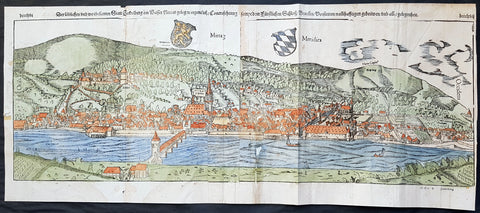
1574 Sebastian Munster Large Antique Birds Eye City View of Heidelberg, Germany
- Title : Die Statt Heidelberg
- Size: 29in x 13in (740mm x 330mm)
- Ref #: 22692
- Date : 1574
- Condition: (B) Good Condition
Description:
This large hand coloured, original antique wood-block engraved birds-eye view of the German City of Heidelberg was published in the 1574 edition of Sebastian Munsters Cosmographia.
There were 2 large folding views in Cosmographia, both German cities, Wormbs and Heidelberg. As these were large folding views they were easily torn and damaged and so quiet rare, especially from the earlier editions.
The Cosmographia or Cosmography was first published in 1544 and is the earliest German-language description of the world.
It had numerous editions in different languages including Latin, French (translated by François de Belleforest), Italian, English, and Czech. The last German edition was published in 1628. The Cosmographia was one of the most successful and popular books of the 16th century and passed through 24 editions in 100 years. This success was due to the notable woodcuts (some by Hans Holbein the Younger, Urs Graf, Hans Rudolph Manuel Deutsch, and David Kandel). It was most important in reviving geography in 16th-century Europe. Among the notable maps within Cosmographia is the map Die Newe Welt oder Inseln, which is credited as the first map to show the American continents as geographically unique.
Munsters earlier geographic works were Germania descriptio (1530) and Mappa Europae (1536). In 1540, he published a Latin edition of Ptolemys Geographia, with numerous illustrations.
General Definitions:
Paper thickness and quality: - Heavy and stable
Paper color : - off white
Age of map color: - Original
Colors used: - Orange, yellow, blue, red
General color appearance: - Authentic
Paper size: - 29in x 13in (740mm x 330mm)
Plate size: - 29in x 13in (740mm x 330mm)
Margins: - Min 1/2in (12mm)
Imperfections:
Margins: - Left margin cropped to plate-mark, light age toning repair to right & bottom margins
Plate area: - Left plate small loss along centrer-fold, light spotting & creasing
Verso: - Left plate backed onto contemporary paper
Background:
Heidelberg is a college town in Baden-Wurttemberg situated on the river Neckar in south-west Germany.
Located about 78 km south of Frankfurt, Heidelberg is the fifth-largest city in the German state.
Founded in 1386, Heidelberg University is Germany\'s oldest and one of Europe\'s most reputable universities.
Heidelberg University played a leading part in the era of humanism and the Reformation, and the conflict between Lutheranism and Calvinism, in the 15th and 16th centuries. Heidelberg\'s library, founded in 1421, is the oldest existing public library in Germany. In April 1518, a few months after proclaiming his 95 Theses, Martin Luther was received in Heidelberg, to defend them. In 1537, the castle located higher up the mountain was destroyed by a gunpowder explosion. The duke\'s palace was built at the site of the lower castle.
The siege of Heidelberg 1622
Elector Frederick III, sovereign of the Electoral Palatinate from 1559 to 1576, commissioned the composition of a new Catechism for his territory. While the catechism\'s introduction credits the entire theological faculty here (at the University of Heidelberg) and all the superintendents and prominent servants of the church for the composition of the catechism, Zacharius Ursinus is commonly regarded as the catechism\'s principal author. Caspar Olevianus (1536–1587) was formerly asserted as a co-author of the document, though this theory has been largely discarded by modern scholarship. Johann Sylvan, Adam Neuser, Johannes Willing, Thomas Erastus, Michael Diller, Johannes Brunner, Tilemann Mumius, Petrus Macheropoeus, Johannes Eisenmenger, Immanuel Tremellius and Pierre Boquin are all likely to have contributed to the Catechism in some way. Frederick himself wrote the preface to the Catechism and closely oversaw its composition and publication. Frederick, who was officially Lutheran but had strong Reformed leanings, wanted to even out the religious situation of his highly Lutheran territory within the primarily Catholic Holy Roman Empire. The Council of Trent had just concluded with its conclusions and decrees against the Protestant faiths, and the Peace of Augsburg had only granted toleration for Lutheranism within the empire where the ruler was Lutheran. One of the aims of the catechism was to counteract the teachings of the Roman Catholic Church as well as Anabaptists and \"strict\" Gnesio-Lutherans like Tilemann Heshusius and Matthias Flacius, who were resisting Frederick\'s Reformed influences, particularly on the matter of Eucharist (the Lord\'s Supper). The Catechism-based each of its statements on biblical proof-texts, and Frederick himself would defend it as biblical, not reformed, at the 1566 Diet of Augsburg when he was called to answer to charges of violating the Peace of Augsburg. This was the Heidelberg Catechism, officially called the Catechism, or Christian Instruction, according to the Usages of the Churches and Schools of the Electoral Palatinate.
In November 1619, the royal crown of Bohemia was offered to the Elector, Frederick V. (He was married to Elizabeth, eldest daughter of James VI and I of Scotland and England, respectively.) Frederick became known as the Winter King, as he reigned for only one winter before the Imperial House of Habsburg regained the crown by force. His overthrow in 1621 marked the beginning of the Thirty Years War. In 1622, after a siege of two months, the armies of the Catholic League, commanded by Johann Tserclaes, Count of Tilly, captured the town. Tilly gave the famous Bibliotheca Palatina from the Church of the Holy Spirit to the Pope as a present. The Catholic Bavarian branch of the House of Wittelsbach gained control over the Palatinate and the title of Prince-Elector. In 1648, at the end of the war, Frederick Vs son Charles I Louis, Elector Palatine, was able to recover his titles and lands.
In late 1634 Imperialist forces attempted to take back the city, as the Swedish army had conquered it. They quickly took the city, but were unable to take the castle. As they prepared to blow up its fortifications with gunpowder the French army arrived, 30,000 men strong, led by Urbain de Maillé-Brézé, who had fought in many battles and participated in the Siege of La Rochelle (1627–1628), and Jacques-Nompar de Caumont, duc de La Force. They ended the siege and drove off the Catholic forces.
To strengthen his dynasty, Charles I Louis arranged the marriage of his daughter Liselotte to Philip I, Duke of Orléans, brother of Louis XIV, king of France. In 1685, after the death of Charles Louis\' son, Elector Charles II, Louis XIV laid claim to his sister-in-laws inheritance. The Germans rejected the claim, in part because of religious differences between local Protestants and the French Catholics, as the Protestant Reformation had divided the peoples of Europe. The War of the Grand Alliance ensued. In 1689, French troops took the town and castle, bringing nearly total destruction to the area in 1693. As a result of the destruction due to repeated French invasions related to the War of the Palatinate Succession coupled with severe winters, thousands of Protestant German Palatines emigrated from the lower Palatinate in the early 18th century. They fled to other European cities and especially to London (where the refugees were called the poor Palatines). In sympathy for the Protestants, in 1709–1710, Queen Anne\'s government arranged transport for nearly 6,000 Palatines to New York. Others were transported to Pennsylvania, and to South Carolina. They worked their passage and later settled in the English colonies there.
In 1720, after assigning a major church for exclusively Catholic use, religious conflicts with the mostly Protestant inhabitants of Heidelberg caused the Roman Catholic Prince-Elector Charles III Philip to transfer his residence to nearby Mannheim. The court remained there until the Elector Charles Theodore became Elector of Bavaria in 1777 and established his court in Munich. In 1742, Elector Charles Theodore began rebuilding the Palace. In 1764, a lightning bolt destroyed other palace buildings during reconstruction, causing the work to be discontinued.
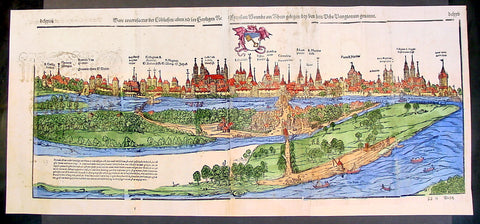
1574 Munster Large Antique Print View of The City of Wormbs, Germany
- Title : Die Statt Wormbs
- Ref #: 22670
- Size: 27in x 13in (685mm x 330mm)
- Date : 1574
- Condition: (A) Very Good Condition
Description:
This large folding original antique print a View of the important German city ofWormbs, south of Hamburg was published in the 1574 release of Sebastian MunstersCosmographia published by Sebastian Petri, Basle.
(This is a reasonably scarce map as the large fold out maps in Cosmographia were easily damaged and lost)
Background: For a variety of reasons town plans were comparatively latecomers in the long history of cartography. Few cities in Europe in the middle ages had more than 20,00 inhabitants and even London in the late Elizabethan period had only 100-150,000 people which in itself was probably 10 times that of any other English city. The Nuremberg Chronicle in 1493 included one of the first town views of Jerusalem, thereafter, for most of the sixteenth century, German cartographers led the way in producing town plans in a modern sense. In 1544 Sebastian Munster issued in Basle his Cosmographia containing roughly sixty-six plans and views, some in the plan form, but many in the old panorama or birds eye view. (Ref: Tooley; M&B)
General Description:
Paper thickness and quality: - Heavy and stable
Paper color: - off white
Age of map color: - Later
Colors used: - Green, blue, yellow, pink
General color appearance: - Authentic
Paper size: - 27in x 13in (685mm x 330mm)
Plate size: - 25in x 10in (635 x 255m)
Margins: - 1/2in (12mm)
Imperfections:
Margins: - Light soiling
Plate area: -Folds re-joined small loss, light soiling, light creasing
Verso: - Light soiling, colour show through, half the map backed in archival material
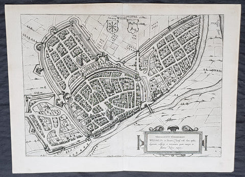
1574 Braun & Hogenberg Antique Map View of Wesel North Rhine-Westphalia, Germany
- Title : Hermannus Hammelman Wesalia in Ducatu Cliuensi
- Size: 21in x 16in (545mm x 410mm)
- Condition: (A+) Fine Condition
- Date : 1574
- Ref #: 81068-1
Description:
This original copper-plate engraved antique map, plan, a birds eye view of city of Wesel in North Rhine-Westphalia, in western Germany was published by Georg Braun & Frans Hogenberg for the 1574 atlas of town plans Civiates Orbis Terrarum intended as a companion to Abraham Ortelius master Atlas Theatrum Orbis Terrarum published in 1570.
General Definitions:
Paper thickness and quality: - Heavy and stable
Paper color : - off white
Age of map color: -
Colors used: -
General color appearance: -
Paper size: - 21in x 16in (545mm x 410mm)
Plate size: - 19in x 13 1/2in (480mm x 340mm)
Margins: - Min 1in (25mm)
Imperfections:
Margins: - None
Plate area: - None
Verso: - None
Background:
Wesel is a city in North Rhine-Westphalia, Germany. It is the capital of the Wesel district.
The city originated from a Franconian manor that was first recorded in the 8th century. In the 12th century, the Duke of Clèves took possession of Wesel. The city became a member of the Hanseatic League during the 15th century. Wesel was second only to Cologne in the lower Rhine region as an entrepôt. It was an important commercial centre: a clearing station for the trans-shipment and trading of goods.
In 1590 the Spanish captured Wesel after a four-year siege. The city changed hands between the Dutch and Spanish several times during the Eighty Years War. In 1672 a French force under Louis II de Bourbon, Prince de Condé captured the city. Wesel was inherited by the Hohenzollerns of the Margraviate of Brandenburg in 1609 but they were unable to take control of Wesel until the Treaty of Nijmegen in 1678. Although the city had been heavily fortified the Prussians evacuated the city during the Seven Years War and it was occupied by the French. It was returned to Prussia at the end of the war. Friedrich Wilhelm von Dossow was the Prussian Governor of Wesel during the 18th century. Wesel was ceded to the French in 1805 under the treaty of Schönbrunn. The French heavily fortified the city constructing a rectangular fort called the Citadelle Napoleon at Büderich and the Citadelle Bonaparte on an island in the Rhine off Wesel. Though blockaded by the Allies in 1813 the city remained in French hands until after the Battle of Waterloo. After the Napoleonic Wars of the early 19th century, the city became part of the Prussian Rhine Province and the Citadelle Napoleon was renamed Fort Blücher.
1699 Danckerts Antique Map of Germany & Central Europe Poland to France to Italy
- Title : Accuratissima Germaniae Tabula
- Ref #: 16295
- Size: 24in x 20 1/2in (610mm x 520mm)
- Date : 1699
- Condition: (A+) Fine Condition
Description:
This large beautifully hand coloured original antique map of central Europe - centering on the various German States but stretching from Poland in the east to France in the west and Venice to the south - by Justus Danckerts was published in 1699.
In the latter half of the fifteenth century Germany, though nominally still part of the Holy Roman Empire, was a fragmented land, split into a score of principalities and Imperial Cities, fiercely jealous of each other but having in common an extraordinary creative urge which produced builders of great churches and cathedrals, workers in stone and wood, metal engravers, painters and makers of scientific instruments, who were the envy of the world. Of all their achievements, the invention of movable-type printing was to have the most profound effect on human relationships. Printing industries soon grew up in many cities, including Nuremberg and Augsburg where wood engraving already flourished and which, with Basle and Strassburg, were also the centres of geographical knowledge. Not only were local and regional maps produced in considerable variety and quantity, but more particularly the geographers and mathematicians of Nuremberg are famous for their globes of the world, some of which are still preserved.
The most important map of the whole of Germany produced in this period was a manuscript dated c. 1464 by Nicholas Cusanus (Khryfts), Cardinal, humanist and scholar, friend of Toscanelli, the Italian geographer, and one of the most brilliant men of his day. The map covering Germany, Southern Scandinavia and the Baltic was printed in 1491, long after the author's death, and it served as a model for a similar map in the Nuremberg Chronicle. We have written in some detail in Chapter 4 of this famous book, first published in 1493, which contained a great number of woodcut views and maps, but as far as cartography is concerned the printing of Ptolemy's Geographia at Ulm in 1482 (and 1486) - the first edition with woodcut maps - was an event of the greatest importance. The most ambitious editions of the Ptolemy maps appeared in 1513 in Strassburg, containing not only maps of the ancient world but also twenty new ones, including one of the 'New World', based on the latest contemporary.
knowledge. This was produced under the guidance of Martin Waldseemuller, a German cartographer, at St Die' in Lorraine, at that time a noted centre of learning. Other editions followed in the years up to 1 541, overlapping with the newer work of Sebastian Mu'~nster, an eminent mathematician and linguist, who settled in Basle and whose prolific output of atlases and maps contained also many plans and views of the great cities of the time. These in turn were superseded by Braun and Hogenberg's Civitates Orbis Terrarumissued in Cologne between the years 1572 and 1618, which was one of the most famous publications of the period.
In the seventeenth century Dutch supremacy in map making and publishing overshadowed Germany no less than England and France and there was to be no revival until the foundation in Nuremberg about the year 1700 of the printing firm of J. B. Homann, whose business acumen started a resurgence of map publishing. He became a member of the Berlin Academy of Sciences and was appointed Geographer to the Emperor in 1715. The business was continued by his son, Johann Christoph, and was eventually bequeathed to the founder's son-in-law on condition that he continued the business under the name of Homann Heirs. Other notable publishing houses active during the century were run by Matthaus Seutter and Tobias Lotter in the rival city of Augsburg. (Ref: Tooley; M&B)
General Description:
Paper thickness and quality: - Heavy and stable
Paper color: - off white
Age of map color: - Early
Colors used: - Yellow, green, red, brown.
General color appearance: - Authentic and fresh
Paper size: - 24in x 20 1/2in (610mm x 520mm)
Plate size: - 23in x 19 1/2in (585mm x 495mm)
Margins: - Min 1/2in (10mm)
Imperfections:
Margins: - None
Plate area: - None
Verso: - Bottom centerfold re-joined, no loss.
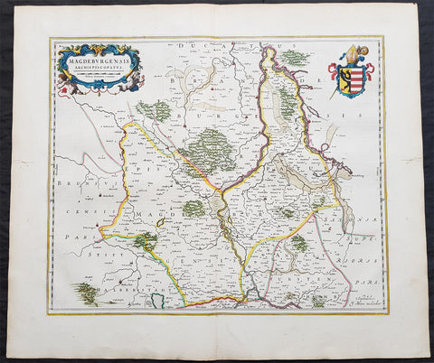
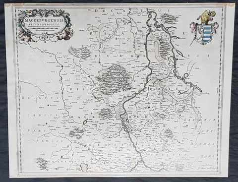
1650 Joan Blaeu Antique Map of Archbishopric of Madenburg Saxony-Anhalt, Germany
- Title : Magdeburgensis Archiepiscopatus
- Ref #: 40335
- Size: 24in x 21in (610mm x 535mm)
- Date : 1650
- Condition: (A+) Fine Condition
Description:
This beautifully hand coloured original copper-plate engraved antique map of the Archbishopric of Madenburg today located in the state of Saxony-Anhalt, Germany, on the Elbe River, was published in the 1650 Dutch edition of Joan Blaeus Atlas Novus.
General Definitions:
Paper thickness and quality: - Heavy and stable
Paper color : - off white
Age of map color: - Original
Colors used: - Blue, pink, red, green, yellow
General color appearance: - Authentic
Paper size: - 24in x 21in (610mm x 535mm)
Plate size: - 21in x 16 1/2in (535mm x 420mm)
Margins: - Min 1in (25mm)
Imperfections:
Margins: - Light age toning
Plate area: - None
Verso: - None
Background:
The Archbishopric of Magdeburg was a Roman Catholic archdiocese (969–1552) and Prince-Archbishopric (1180–1680) of the Holy Roman Empire centered on the city of Magdeburg on the Elbe River.
Planned since 955 and established in 968, the Roman Catholic archdiocese had de facto turned void since 1557, when the last papally confirmed prince-archbishop, the Lutheran Sigismund of Brandenburg came of age and ascended to the see and the Magdeburg cathedral chapter had adopted Lutheranism in 1567, with most parishioners having preceded in their conversion. All his successors were only administrators of the prince-archbishopric and Lutheran too, except of the Catholic layman Leopold William of Austria (1631–1635). In ecclesiastical respect the remaining Catholics and their parishes and abbeys in the former archdiocese were put under supervision of the Archdiocese of Cologne in 1648 and under the jurisdiction of the Apostolic Vicariate of the Northern Missions in 1670.
In political respect the Erzstift, the archiepiscopal and capitular temporalities, had gained imperial immediacy as prince-archbishopric in 1180. Its territory comprised only some parts of the archdiocesan area, such as the city of Magdeburg, the bulk of the Magdeburg Börde, and the Jerichow Land as an integral whole and exclaves comprising about the Saalkreis including Halle upon Saale, Oebisfelde and environs as well as Jüterbog and environs. The prince-archbishopric maintained its statehood as an elective monarchy until 1680. Then Brandenburg-Prussia acquired Magdeburg prince-archbishopric, and after being secularised, transformed it into the Duchy of Magdeburg, a hereditary monarchy in personal union with Brandenburg.
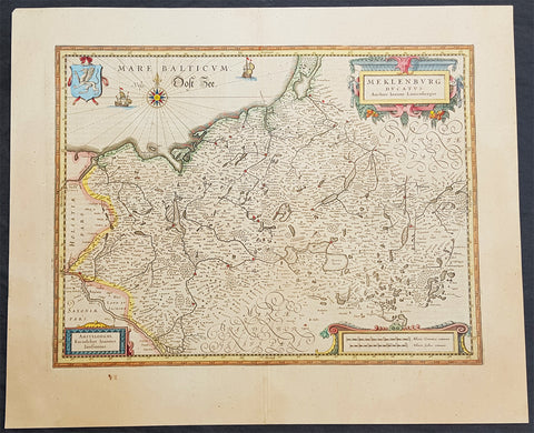
1646 Jan Jansson Antique Map of Mecklenburg NE Germany Rostock, Wizmar, Parchim
- Title : Meklenburg Ducatus
- Ref #: 50185
- Size: 11 1/2in x 8in (290mm x 205mm)
- Date : 1646
- Condition: (A+) Fine Condition
Description:
This beautifully hand coloured original copper-plate engraved antique map of the Mecklenburg, north eastern Germany by Jan Jansson was published in the 1646 Latin edition of Mercators Atlas by Jan Jansson and Henricus Hondius. (Ref: Tooley, Koeman)
General Definitions:
Paper thickness and quality: - Heavy and stable
Paper color : - off white
Age of map color: - Original
Colors used: - Yellow, green, blue, pink
General color appearance: - Authentic
Paper size: - 22in x 18in (560mm x 460mm)
Plate size: - 19in x 14 1/2in (480mm x 370mm)
Margins: - Min 2in (50mm)
Imperfections:
Margins: - None
Plate area: - None
Verso: - None
Background:
Mecklenburg is a historical region in northern Germany comprising the western and larger part of the federal-state Mecklenburg-Vorpommern. The largest cities of the region are Rostock, Schwerin, Neubrandenburg, Wismar and Güstrow.
The name Mecklenburg derives from a castle named Mikilenburg (Old Saxon: big castle, hence its translation into New Latin and Greek: Megalopolis), located between the cities of Schwerin and Wismar. In Slavic language it was known as Veligrad, which also means big castle. It was the ancestral seat of the House of Mecklenburg; for a time the area was divided into Mecklenburg-Schwerin and Mecklenburg-Strelitz among the same dynasty.
Linguistically Mecklenburgers retain and use many features of Low German vocabulary or phonology.
Mecklenburg is the site of many prehistoric dolmen tombs. Its earliest organised inhabitants may have had Celtic origins. By no later than 100 BC the area had been populated by pre-Christian Germanic peoples.
The traditional symbol of Mecklenburg, the grinning steers head (Low German: Ossenkopp, lit.: oxen\'s head, with osse being a synonym for steer and bull in Middle Low German), with an attached hide, and a crown above, may have originated from this period. It represents what early peoples would have worn, i.e. a steers\'s head as a helmet, with the hide hanging down the back to protect the neck from the sun, and overall as a way to instill fear in the enemy.
From the 7th through the 12th centuries, the area of Mecklenburg was taken over by Western Slavic peoples, most notably the Obotrites and other tribes that Frankish sources referred to as Wends. The 11th century founder of the Mecklenburgian dynasty of Dukes and later Grand Dukes, which lasted until 1918, was Nyklot of the Obotrites.
In the late 12th century, Henry the Lion, Duke of the Saxons, conquered the region, subjugated its local lords, and Christianized its people, in a precursor to the Northern Crusades. From 12th to 14th century, large numbers of Germans and Flemings settled the area (Ostsiedlung), importing German law and improved agricultural techniques. The Wends who survived all warfare and devastation of the centuries before, including invasions of and expeditions into Saxony, Denmark and Liutizic areas as well as internal conflicts, were assimilated in the centuries thereafter. However, elements of certain names and words used in Mecklenburg speak to the lingering Slavic influence. An example would be the city of Schwerin, which was originally called Zuarin in Slavic. Another example is the town of Bresegard, the \'gard\' portion of the town name deriving from the Slavic word \'grad\', meaning city or town.
Since the 12th century, the territory remained stable and relatively independent of its neighbours; one of the few German territories for which this is true. During the reformation the Duke in Schwerin would convert to Protestantism and so would follow the Duchy of Mecklenburg.
Like many German territories, Mecklenburg was sometimes partitioned and re-partitioned among different members of the ruling dynasty. In 1621 it was divided into the two duchies of Mecklenburg-Schwerin and Mecklenburg-Güstrow. With the extinction of the Güstrow line in 1701, the Güstrow lands were redivided, part going to the Duke of Mecklenburg-Schwerin, and part going to the new line of Mecklenburg-Strelitz.
In 1815, the two Mecklenburgian duchies were raised to Grand Duchies, the Grand Duchy of Mecklenburg-Schwerin and the Grand Duchy of Mecklenburg-Strelitz, and subsequently existed separately as such in Germany under enlightened but absolute rule (constitutions being granted on the eve of World War I) until the revolution of 1918. Life in Mecklenburg could be quite harsh. Practices such as having to ask for permission from the Grand Duke to get married, or having to apply for permission to emigrate, would linger late into the history of Mecklenburg (i.e. 1918), long after such practices had been abandoned in other German areas. Even as late as the later half of the 19th century the Grand Duke personally owned half of the countryside. The last Duke abdicated in 1918, as monarchies fell throughout Europe. The Duke\'s ruling house reigned in Mecklenburg uninterrupted (except for two years) from its incorporation into the Holy Roman Empire until 1918. From 1918 to 1933, the duchies were free states in the Weimar Republic.
Traditionally Mecklenburg has always been one of the poorer German areas, and later the poorer of the provinces, or Länder, within a unified Germany. The reasons for this may be varied, but one factor stands out: agriculturally the land is poor and can not produce at the same level as other parts of Germany. The two Mecklenburgs made attempts at being independent states after 1918, but eventually this failed as their dependence on the rest of the German lands became apparent.
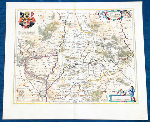
1662 Joan Blaeu Antique Map of Wołow County, Lower Silesia Voivodeship SW Poland
- Title : Ducatus Silesiae Wolanus Authore Jona Sculteto Sprotta Silesio
- Ref #: 93430
- Size: 24in x 20in (610mm x 510mm)
- Date : 1662
- Condition: (A) Very Good Condition
Description:
This beautifully hand coloured original copper-plate engraved antique, rare map of Wolow County, located at the time of publication in the Duchy of Głogow, in Lower Silesia, today SW Poland, was published in Joan Blaeu greatest publication, the first 1662 French edition of Atlas Major,.
As this map was only published over a 10 year period, as most of the plates were destroyed in the disasterous 1672 fire that wiped out the Blaeu publishing house, this map is extremely rare especially with original hand colour, such as this map.
General Definitions:
Paper thickness and quality: - Heavy and stable
Paper color : - off white
Age of map color: - Original
Colors used: - Yellow, green, blue, pink
General color appearance: - Authentic
Paper size: - 24in x 20in (610mm x 510mm)
Plate size: - 21in x 16 1/2in (535mm x 420mm)
Margins: - Min 1in (25mm)
Imperfections:
Margins: - Light soiling
Plate area: - Offsetting
Verso: - Offsetting
Background:
Wolow is a town in Lower Silesian Voivodeship in south-western Poland. It is the seat of Wołów County and Gmina Wołów. It lies approximately 38 kilometres north-west of the regional capital Wrocław.
The area around Wołów has been settled since prehistoric times. It became part of the emerging Polish state in the late 10th century under Mieszko I of Poland. The town was first mentioned in 1157 when a wooden castle founded by Senior Duke of Poland Władysław II the Exile is documented, which developed into a castle complex, which was again mentioned in 1202. Two villages developed near the castle, one of them called Wołowo. Probably in the second half of the 13th century the town was founded near Wołowo and partially on the soil of the second village. Wołów received Magdeburg town rights about 1285 at the time of German Ostsiedlung in the region; a Vogt is mentioned in 1288.
At that time Wołów belonged to the Duchy of Głogów, after 1312 to the Duchy of Oleśnica. With the duchy it came under the suzerainty of Bohemia in 1328. From 1473 dates the oldest known seal of the town, which already shows an ox, as do all later seals. Wołów was ruled by local Polish dukes until 1492, and soon after, in 1495, it came into the possession of the Czech Podiebrad family, then in 1517 it came into the hands the Hungarian magnate Johann Thurzó, before returning to Piast rule in 1523, by passing to the Duchy of Legnica. It remained there until the Piast dukes of Legnica-Brzeg-Wołów died out in 1675. As a result of the Thirty Years War, the towns population fell by half.
The Protestant Reformation was introduced to the town in 1522 by duke Frederick II. After the extinction of the local Piasts the duchy passed to the House of Habsburg, which opposed the Protestant denomination in the town, as part of the Counter-Reformation. In 1682 the towns parish church was closed and given to the Catholics. According to the Treaty of Altranstädt the church however was already returned to the Protestants in 1707 and stayed Protestant until 1945. The small Catholic minority in return received a Josephinian curacy.
In 1742 Wołów was annexed by Prussia. The duchy was divided into two districts and the town became county seat of one of the districts. The structure of the town was, until 1700, defined by craft, especially clothiers. As the seat of a duchy and a district administrative function however became more and more important. The industrialization played only a minor role and mostly affected smaller companies of the timber industry. In 1781 the city suffered a fire.
The town was part of Germany from 1871 to 1945. In January 1945 – just before town was taken by the Red Army – the Wehrmacht evacuated the German population westwards.
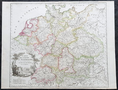
1757 Robert De Vaugondy Large Antique Map of the German States, Bohemia, Austria
- Title : Carte De L Empire D Allemagne..Les Routes Des Postes
- Size: 26in x 19 1/2in (660mm x 495mm)
- Condition: (A+) Fine Condition
- Date : 1757
- Ref #: 41567
Description:
This large magnificent hand coloured original copper-plate engraved antique map of various individual states of Germany including Austria, Bohemia, Switzerland & The Netherlands by Robert De Vaugondy was published in the 1757 edition of De Vaugondys famous The Atlas Universel
General Definitions:
Paper thickness and quality: - Heavy and stable
Paper color : - off white
Age of map color: - Original & later
Colors used: - Blue, pink, red, green, yellow
General color appearance: - Authentic
Paper size: - 26in x 19 1/2in (660mm x 495mm)
Plate size: - 22 1/2in x 19 1/2in (570mm x 495mm)
Margins: - Min 1/4in (5mm)
Imperfections:
Margins: - None
Plate area: - None
Verso: - None
Background:
In the 18th century, the Holy Roman Empire consisted of approximately 1,800 territories. The elaborate legal system initiated by a series of Imperial Reforms (approximately 1450–1555) created the Imperial Estates and provided for considerable local autonomy among ecclesiastical, secular, and hereditary states, reflected in Imperial Diet. The House of Habsburg held the imperial crown from 1438 until the death of Charles VI in 1740. Having no male heirs, he had convinced the Electors to retain Habsburg hegemony in the office of the emperor by agreeing to the Pragmatic Sanction. This was finally settled through the War of Austrian Succession; in the Treaty of Aix-la-Chapelle, Charles VI\'s daughter Maria Theresa ruled the Empire as Empress Consort when her husband, Francis I, became Holy Roman Emperor. From 1740, the dualism between the Austrian Habsburg Monarchy and the Kingdom of Prussia dominated the German history.
In 1772, then again in 1793 and 1795, the two dominant German states of Prussia and Austria, along with the Russian Empire, agreed to the Partitions of Poland; dividing among themselves the lands of the Polish–Lithuanian Commonwealth. As a result of the partitions, millions of Polish speaking inhabitants fell under the rule of the two German monarchies. However, the annexed territories though incorporated into the Kingdom of Prussia and the Habsburg Realm, were not legally considered as a part of the Holy Roman Empire. During the period of the French Revolutionary Wars, along with the arrival of the Napoleonic era and the subsequent final meeting of the Imperial Diet, most of the secular Free Imperial Cities were annexed by dynastic territories; the ecclesiastical territories were secularised and annexed. In 1806 the Imperium was dissolved; many German states, particularly the Rhineland states, fell under the influence of France. Until 1815, France, Russia, Prussia and the Habsburgs (Austria) competed for hegemony in the German states during the Napoleonic Wars
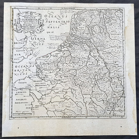
1611 Philipp Cluver Antique Map The Netherlands, Belgium, parts France & Germany
- Title : Germaniae Cisrhenanae ut interl. caesaris et Traiani suit imperii Scaldis item Mosae ac Rheni ostiorum antiqua Descriptio
- Size: 11 1/2in x 11 1/2in (295mm x 295mm)
- Condition: (A+) Fine Condition
- Date : 1611
- Ref #: 23967
Description:
This fine original wood-block engraved antique map of The Netherlands, Belgium, Northern France and parts of Western Germany was published in the 1611 edition of Philip Cluvers first publication Commentarius de tribus Rheni alveis, et ostiis; item. De Quinque populis quondam accolis; scilicet de Toxandris, Batavis, Caninefatibus, Frisiis, ac Marsacis. (Ref: King; Tooley; M&B)
General Definitions:
Paper thickness and quality: - Heavy and stable
Paper color : - off white
Age of map color: -
Colors used: -
General color appearance: -
Paper size: - 11 1/2in x 11 1/2in (295mm x 295mm)
Plate size: - 10in x 10in (255mm x 255mm)
Margins: - Min 1/2in (12mm)
Imperfections:
Margins: - Light age toning to left & right margins
Plate area: - None
Verso: - None
Background:
Clüver was an antiquary, who was given a special appointment at Leiden as geographer and put in charge of the university\'s library, but his lifes project, it developed, was a general study of the geography of Antiquity, based not only on classical literary sources, but — and this was his contribution — supplemented by wide travels and local inspections. He became virtually the founder of historical geography.
Clüvers first work, in 1611, concerning the lower reaches of the Rhine and its tribal inhabitants in Roman times (Commentarius de tribus Rheni alveis, et ostiis; item. De Quinque populis quondam accolis; scilicet de Toxandris, Batavis, Caninefatibus, Frisiis, ac Marsacis) touched a source of national pride among the Seventeen Provinces, for the Dutch were enjoying a twelve years truce in their Eighty Years War of liberation.
Cluver, Philipp 1580 – 1622
Clüver - also Klüwer, Cluwer, or Cluvier, Latinized as Philippus Cluverius and Philippi Cluverii) - was an Early Modern German geographer and historian.
Clüver was born in Danzig (Gdańsk), in Royal Prussia, a province of the Kingdom of Poland. After spending some time at the Polish court of Sigismund III Vasa, he began the study of law at the University of Leiden (Dutch Republic), but soon he turned his attention to history and geography, which were then taught there by Joseph Scaliger.
Clüver received science education from his father, who was Münzmeister at Danzig (coin master), but when Clüver went into different studies, his father stopped supporting his studies. He therefore travelled from Leiden across Hungary to Bohemia, where he did military service for a few years. While in Bohemia, he translated into Latin a defense by Baron Popel Lobkowitz, who was imprisoned. Upon his return to Leiden, he faced sanctions by the imperial (Habsburg) authorities for this, which however he could avoid with the help of his Leiden friends.
Clüver also travelled in England, Scotland, and France. He did all travel on foot, finally returning to Leiden, where (after 1616) he received a regular pension from the university. He died in Leiden.
Clüver was an antiquary, who was given a special appointment at Leiden as geographer and put in charge of the university\\\'s library, but his lifes project, it developed, was a general study of the geography of Antiquity, based not only on classical literary sources, but — and this was his contribution — supplemented by wide travels and local inspections. He became virtually the founder of historical geography.
Clüver\\\'s first work, in 1611, concerning the lower reaches of the Rhine and its tribal inhabitants in Roman times (Commentarius de tribus Rheni alveis, et ostiis; item. De Quinque populis quondam accolis; scilicet de Toxandris, Batavis, Caninefatibus, Frisiis, ac Marsacis) touched a source of national pride among the Seventeen Provinces, for the Dutch were enjoying a twelve years\\\' truce in their Eighty Years War of liberation.
Clüvers Germaniae antiquae libri tres (Leiden, 1616) depends on Tacitus and other Latin authors. A volume on the antiquities of Sicily, with notes on Sardinia and Corsica (Sicilia Antiqua cum minoribus insulis ei adjacentibus item Sardinia et Corsica), published at Leiden by Louis Elsevier in 1619, is a useful source, with many reference from writers of Antiquity and maps that are often detached and sold to map collectors. His Introductio in universam geographiam, totally 6 parts, (published posthumously from 1624) was the first comprehensive modern geography, and became a standard geographical textbook.
Clüver was also a prolific a writer on mathematical and theological subjects. He is remembered by collectors and historians of cartography for his edition of Ptolemys Geographia (based on Mercators edition of 1578) and for miniature atlases that were reprinted for most of the 17th century. Many of his maps were etched for him by Petrus Bertius.
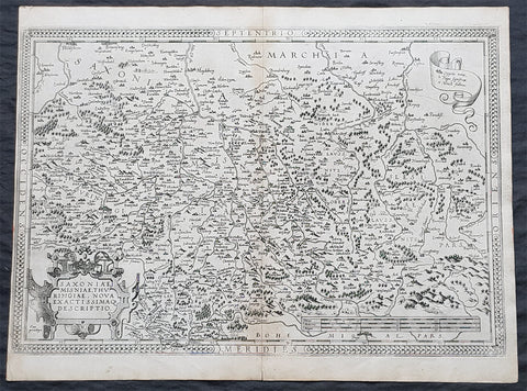
1575 Abraham Ortelius Antique Map Obersachsen, Meissen and Thuringen, Germany
- Title : Saxoniae Misniae, Thuringiae, Nova Exactissimaq Descriptio
- Size: 20 1/2in x 15 1/2in (520mm x 390mm)
- Condition: (A+) Fine Condition
- Date : 1587
- Ref #: 30032
Description:
These original copper-plate engraved antique map of the Obersachsen, Meissen and Thuringen regions of Germany was published in the 1575 French edition of Abraham Ortelius Atlas Theatrum Orbis Terrarum.
General Definitions:
Paper thickness and quality: - Heavy and stable
Paper color : - off white
Age of map color: -
Colors used: -
General color appearance: -
Paper size: - 20 1/2in x 15 1/2in (520mm x 390mm)
Plate size: - 20in x 13 1/2in (510mm x 345mm)
Margins: - Min 1/4in (4mm)
Imperfections:
Margins: - Light soiling
Plate area: - None
Verso: - Soiling
Background:
Ortelius regional map of Germany, showing the area between Berlin and Braunschweig in the north, to Prague in the south and Silesia in the east. With Chemnitz, Dresden, Leipzig, Wittenberg and Erfurt
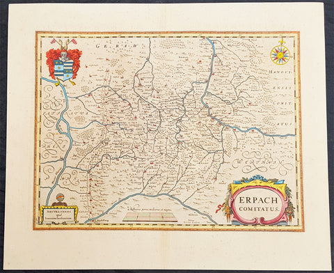
1646 Jan Jansson Antique Map Erbach Hesse & Baden-Württemberg Heidelberg Germany
- Title : Erpach Comitatus
- Ref #: 50182
- Size: 22in x 18in (560mm x 460mm)
- Date : 1646
- Condition: (A+) Fine Condition
Description:
This beautifully hand coloured original copper-plate engraved antique map of the Erbach im Odenwald area in the Baden-Württemberg & Hesse regions of southern Germany, framed by the Neckar River in the south, Rhine River to the west and the Main river to the east (major towns and cities of Heidelberg, Gensheim, Worms, Miltenberg and Oldenburg) by Jan Jansson was published in the 1646 Latin edition of Mercators Atlas by Jan Jansson and Henricus Hondius. (Ref: Tooley, Koeman)
General Definitions:
Paper thickness and quality: - Heavy and stable
Paper color : - off white
Age of map color: - Original
Colors used: - Yellow, green, blue, pink
General color appearance: - Authentic
Paper size: - 22in x 18in (560mm x 460mm)
Plate size: - 19in x 14 1/2in (480mm x 370mm)
Margins: - Min 2in (50mm)
Imperfections:
Margins: - None
Plate area: - None
Verso: - None
Background:
Erbach is a town and the district seat of the Odenwaldkreis (district) in Hesse, Germany.
Baden-Württemberg is a state in southwest Germany, east of the Rhine, which forms the border with France.
Hesseis a federal state (Land) of the Federal Republic of Germany
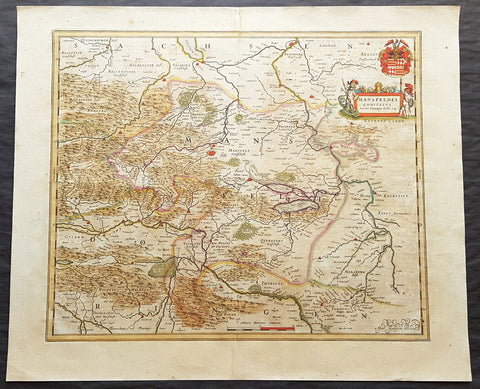
1662 Joan Blaeu Antique Map of Mansfeld Land, in SW Saxony-Anhalt, Germany
- Title : Mansfelda Comitatus Auctore Tilemanno Stella Sig.
- Ref #: 50180
- Size: 23 1/2in x 19 1/2in (600mm x 495mm)
- Date : 1662
- Condition: (A) Very Good Condition
Description:
This beautifully hand coloured original copper-plate engraved antique map of the ancient region of Mansfeld Land located in the in southwestern region of Saxony-Anhalt, Germany - centering on the city of Mansfeld - by was published in the 1662 Latin edition edition of Joan Blaeus Atlas Major.
General Definitions:
Paper thickness and quality: - Heavy and stable
Paper color : - off white
Age of map color: - Original
Colors used: - Blue, pink, red, green, yellow
General color appearance: - Authentic
Paper size: - 23 1/2in x 19 1/2in (600mm x 495mm)
Plate size: - 19 1/2in x 16 1/2in (495mm x 420mm)
Margins: - Min 1in (25mm)
Imperfections:
Margins: - Light age toning
Plate area: - Light age toning
Verso: - Light age toning
Background:
Mansfeld Land is a region in the southwestern corner of the German state of Saxony-Anhalt. The region derives its name from the counts of Mansfeld, who ruled this region for about 1,000 years.
The House of Mansfeld, whose members belonged to the Saxon nobility and served as counts in the Hassegau, was first documented in a 973 deed. The counts built Mansfeld Castle, whose foundations date back to the late 11th century, when one Hoyer of Mansfeld served as field marshal to Emperor Henry V. The first reference of the fortress coincides with the extinction of the elder line in 1229. The estates were inherited by the Lords of Querfurt, who also adopted the comital title, calling themselves Counts of Mansfeld from that time on.
The settlement of Mansfeld received town privileges in 1400, and grew through the development of copper and silver mining, an activity in which Hans Luder from Möhra, father to Martin Luther and Mansfeld citizen from 1484, was employed as a master smelter. Luthers family had arrived into a modest prosperity, he himself attended the local school between 1488 and 1496. The building known as Luther\'s School had to be torn down and rebuilt in 2000 due to structural problems. His parents house is preserved and today a museum. Luther also acted as an altar server at the St George parish church.
The Counts of Mansfeld had already lost Imperial immediacy in 1580. When the comital line finally became extinct in 1780, the estates around Mansfeld were incorporated into the Prussian Duchy of Magdeburg. The town retained the status of an independent city (Immediatstadt), it was temporarily part of the Napoleonic Kingdom of Westphalia and after the 1815 Congress of Vienna belonged to the Prussian Province of Saxony.
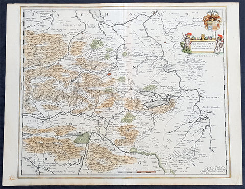
1638 Willem Blaeu Antique Map of Mansfeld Land, in SW Saxony-Anhalt, Germany
- Title : Mansfelda Comitatus
- Ref #: 70078
- Size: 22 1/2in x 17in (570mm x 430mm)
- Date : 1638
- Condition: (A+) Fine Condition
Description:
This beautifully hand coloured original copper-plate engraved antique map of the ancient region of Mansfeld Land located in the in southwestern region of Saxony-Anhalt, Germany - centering on the city of Mansfeld - by was published in the 1638 Latin edition edition of Willem Blaeus Atlas Novus.
General Definitions:
Paper thickness and quality: - Heavy and stable
Paper color : - off white
Age of map color: - Original
Colors used: - Blue, pink, red, green, yellow
General color appearance: - Authentic
Paper size: - 22 1/2in x 17in (570mm x 430mm)
Plate size: - 19 1/2in x 16 1/4in (495mm x 420mm)
Margins: - Min 1/2in (12mm)
Imperfections:
Margins: - Light age toning
Plate area: - None
Verso: - None
Background:
Mansfeld Land is a region in the southwestern corner of the German state of Saxony-Anhalt. The region derives its name from the counts of Mansfeld, who ruled this region for about 1,000 years.
The House of Mansfeld, whose members belonged to the Saxon nobility and served as counts in the Hassegau, was first documented in a 973 deed. The counts built Mansfeld Castle, whose foundations date back to the late 11th century, when one Hoyer of Mansfeld served as field marshal to Emperor Henry V. The first reference of the fortress coincides with the extinction of the elder line in 1229. The estates were inherited by the Lords of Querfurt, who also adopted the comital title, calling themselves Counts of Mansfeld from that time on.
The settlement of Mansfeld received town privileges in 1400, and grew through the development of copper and silver mining, an activity in which Hans Luder from Möhra, father to Martin Luther and Mansfeld citizen from 1484, was employed as a master smelter. Luthers family had arrived into a modest prosperity, he himself attended the local school between 1488 and 1496. The building known as Luther\'s School had to be torn down and rebuilt in 2000 due to structural problems. His parents house is preserved and today a museum. Luther also acted as an altar server at the St George parish church.
The Counts of Mansfeld had already lost Imperial immediacy in 1580. When the comital line finally became extinct in 1780, the estates around Mansfeld were incorporated into the Prussian Duchy of Magdeburg. The town retained the status of an independent city (Immediatstadt), it was temporarily part of the Napoleonic Kingdom of Westphalia and after the 1815 Congress of Vienna belonged to the Prussian Province of Saxony.
1650 Joan Blaeu Antique Map Archbishopic of Madenburg in Saxony-Anhalt, Germany
- Title : Magdeburgensis Archiepiscopatus...Amstelaedami J Blaeu excudebat
- Size: 21in x 17in (530mm x 430mm)
- Condition: (A+) Fine Condition
- Date : 1650
- Ref #: 70075
Description:
This beautifully hand coloured original copper-plate engraved antique map of the Archbishopric of Madenburg today located in the state of Saxony-Anhalt, Germany, on the Elbe River, was published in the 1650 edition of Joan Blaeus Atlas Novus.
General Definitions:
Paper thickness and quality: - Heavy and stable
Paper color : - off white
Age of map color: - Original
Colors used: - Yellow, Green, pink
General color appearance: - Authentic
Paper size: - 21in x 17in (530mm x 430mm)
Plate size: - 21in x 17in (530mm x 430mm)
Margins: - Min 1/4in (6mm)
Imperfections:
Margins: - Top margin cropped to plate-mark
Plate area: - None
Verso: - None
Background:
The Archbishopric of Magdeburg was a Roman Catholic archdiocese (969–1552) and Prince-Archbishopric (1180–1680) of the Holy Roman Empire centered on the city of Magdeburg on the Elbe River.
Planned since 955 and established in 968, the Roman Catholic archdiocese had de facto turned void since 1557, when the last papally confirmed prince-archbishop, the Lutheran Sigismund of Brandenburg came of age and ascended to the see and the Magdeburg cathedral chapter had adopted Lutheranism in 1567, with most parishioners having preceded in their conversion. All his successors were only administrators of the prince-archbishopric and Lutheran too, except of the Catholic layman Leopold William of Austria (1631–1635). In ecclesiastical respect the remaining Catholics and their parishes and abbeys in the former archdiocese were put under supervision of the Archdiocese of Cologne in 1648 and under the jurisdiction of the Apostolic Vicariate of the Northern Missions in 1670.
In political respect the Erzstift, the archiepiscopal and capitular temporalities, had gained imperial immediacy as prince-archbishopric in 1180. Its territory comprised only some parts of the archdiocesan area, such as the city of Magdeburg, the bulk of the Magdeburg Börde, and the Jerichow Land as an integral whole and exclaves comprising about the Saalkreis including Halle upon Saale, Oebisfelde and environs as well as Jüterbog and environs. The prince-archbishopric maintained its statehood as an elective monarchy until 1680. Then Brandenburg-Prussia acquired Magdeburg prince-archbishopric, and after being secularised, transformed it into the Duchy of Magdeburg, a hereditary monarchy in personal union with Brandenburg.
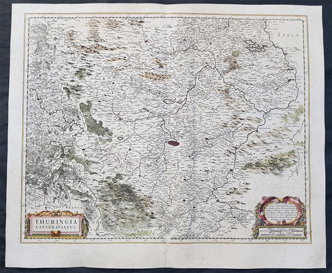
1639 Henricus Hondius Original Antique Map of the German State of Thuringia
- Title : Thuringia Lantgraviatus
- Date : 1639
- Size: 22 1/2in x 19in (570mm x 485mm)
- Ref #: 23434
- Condition: (A) Very Good Condition
Description:
This fine original antique map of the German State of Thuringia or Thüringen in central Germany was published by Henricus Hondius in the 1639 edition of Mercators Atlas.
The map centers on the city of Erfurt and alos includes major cities of Gotha, Weimar, Schwartzburg, Halle, Jena, Mulhausen and others
General Definitions:
Paper thickness and quality: - Heavy and stable
Paper color : - off white
Age of map color: - Original
Colors used: - Yellow, green, blue, pink
General color appearance: - Authentic
Paper size: - 22 1/2in x 19in (570mm x 485mm)
Plate size: - 20 1/2in x 16 1/2in (520mm x 420mm)
Margins: - Min 1in (25mm)
Imperfections:
Margins: - None
Plate area: - Light creasing along centerfold,
Verso: - Small repair to bottom left margin
Background:
Named after the Thuringii tribe who occupied it around AD 300, Thuringia came under Frankish domination in the 6th century.
Thuringia became a landgraviate in 1130 AD. After the extinction of the reigning Ludowingian line of counts and landgraves in 1247 and the War of the Thuringian Succession (1247–1264), the western half became independent under the name of \"Hesse\", never to become a part of Thuringia again. Most of the remaining Thuringia came under the rule of the Wettin dynasty of the nearby Margraviate of Meissen, the nucleus of the later Electorate and Kingdom of Saxony. With the division of the house of Wettin in 1485, Thuringia went to the senior Ernestine branch of the family, which subsequently subdivided the area into a number of smaller states, according to the Saxon tradition of dividing inheritance amongst male heirs. These were the \"Saxon duchies\", consisting, among others, of the states of Saxe-Weimar, Saxe-Eisenach, Saxe-Jena, Saxe-Meiningen, Saxe-Altenburg, Saxe-Coburg, and Saxe-Gotha; Thuringia became merely a geographical concept.
Thuringia generally accepted the Protestant Reformation, and Roman Catholicism was suppressed as early as 1520; priests who remained loyal to it were driven away and churches and monasteries were largely destroyed, especially during the German Peasants\' War of 1525. In Mühlhausen and elsewhere, the Anabaptists found many adherents. Thomas Müntzer, a leader of some non-peaceful groups of this sect, was active in this city. Within the borders of modern Thuringia the Roman Catholic faith only survived in the Eichsfeld district, which was ruled by the Archbishop of Mainz, and to a small degree in Erfurt and its immediate vicinity.
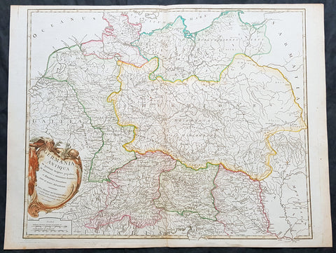
1757 Robert De Vaugondy Large Antique Map of Germania, Germany During Roman Era
- Title : Germania Antiqua in quatuor magnos populos...Autore Robert De Vaugondy
- Size: 26in x 19 1/2in (660mm x 495mm)
- Condition: (A+) Fine Condition
- Date : 1757
- Ref #: 41548
Description:
This large magnificent hand coloured original copper-plate engraved antique map of Ancient Germania, Germany, during the Roman Era by Robert De Vaugondy was published in the 1757 edition of De Vaugondys famous The Atlas Universel
General Definitions:
Paper thickness and quality: - Heavy and stable
Paper color : - off white
Age of map color: - Original & later
Colors used: - Blue, pink, red, green, yellow
General color appearance: - Authentic
Paper size: - 26in x 19 1/2in (660mm x 495mm)
Plate size: - 22 1/2in x 19 1/2in (570mm x 495mm)
Margins: - Min 1/4in (5mm)
Imperfections:
Margins: - None
Plate area: - None
Verso: - None
Background:
Germania was the Roman term for the geographical region in north-central Europe inhabited mainly by Germanic peoples.
It extended from the Danube in the south to the Baltic Sea, and from the Rhine in the west to the Vistula. The Roman portions formed two provinces of the Empire, Germania Inferior to the north (present-day southern Netherlands, Belgium, and western Germany), and Germania Superior to the south (Switzerland, southwestern Germany, and eastern France).
Germania was inhabited mostly by Germanic tribes, but also Celts, Balts, Scythians and later on Early Slavs. The population mix changed over time by assimilation, and especially by migration. The ancient Greeks were the first to mention the tribes in the area. Later, Julius Caesar wrote about warlike Germanic tribesmen and their threat to Roman Gaul, and there were military clashes between the Romans and the indigenous tribes. Tacitus wrote the most complete account of Germania that still survives.
The origin of the term Germania is uncertain, but was known by Caesar\'s time, and may be Gaulish in origin.
Germania was inhabited by different tribes, most of them Germanic but also some Celtic, proto-Slavic, Baltic and Scythian peoples. The tribal and ethnic makeup changed over the centuries as a result of assimilation and, most importantly, migrations. The Germanic people spoke several different dialects.
Classical records show little about the people who inhabited the north of Europe before the 2nd century BC. In the 5th century BC, the Greeks were aware of a group they called Celts (Keltoi). Herodotus also mentioned the Scythians but no other tribes. At around 320 BC, Pytheas of Massalia sailed around Britain and along the northern coast of Europe, and what he found on his journeys was so strange that later writers refused to believe him. He may have been the first Mediterranean to distinguish the Germanic people from the Celts. Contact between German tribes and the Roman Empire did take place and was not always hostile. Recent excavations of the Waldgirmes Forum show signs that a civilian Roman town was established there, which has been interpreted to mean that Romans and Germanic tribesmen were living in peace, at least for a while.
Caesar described the cultural differences between the Germanic tribesmen, the Romans, and the Gauls in his book Commentarii de Bello Gallico, where he recalls his defeat of the Suebi tribes at the Battle of Vosges. He describes them at length at the beginning of Book IV and the middle of Book VI. He states that the Gauls, although warlike, had a functional society and could be civilized, but that the Germanic tribesmen were far more savage and were a threat to Roman Gaul and Rome itself. Caesar said the Germanic tribes were nomadic, with no notable settlements and a primitive culture. He used this as one of his justifications for why they had to be conquered. His accounts of barbaric northern tribes could be described as an expression of the superiority of Rome, including Roman Gaul.
Caesars accounts portray the Roman fear of the Germanic tribes and the threat they posed. The perceived menace of the Germanic tribesmen proved accurate. The most complete account of Germania that has been preserved from Roman times is Tacitus Germania.
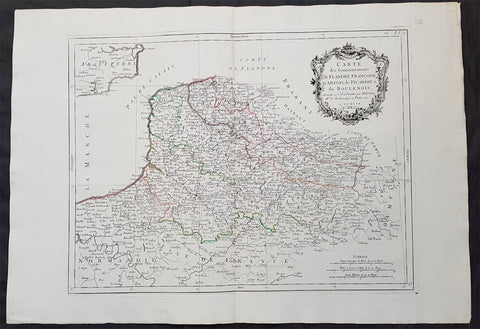
1777 F. Santini Antique Map Flanders Artois Hainaut Picardy Regions of Belgium
- Title : Carte Des Gouvernements de Flandre Francois d Artois de Picardie et du Boulenois...P Santini...1777
- Size: 30in x 21in (760mm x 535mm)
- Condition: (A+) Fine Condition
- Date : 1777
- Ref #: 50221
Description:
This large magnificent original copper-plate engraved antique map of Belgium and parts of Northern France made up of the provinces of Flanders, Artois, Hainaut, Picardy was engraved in 1777 - the date is engraved in the title cartouche - after Rigobert Bonne in 1771 and was published by Francois Santini (active 1776-84) in his 2 volume edition of Atlas Universal 1776-84.. (Ref: Tooley; M&B)
General Definitions:
Paper thickness and quality: - Heavy and stable
Paper color : - off white
Age of map color: - Original
Colors used: - Blue, pink, red, green, yellow
General color appearance: - Authentic
Paper size: - 30in x 21in (760mm x 535mm)
Plate size: - 23in x 18in (585mm x 460mm)
Margins: - Min 2in (50mm)
Imperfections:
Margins: - None
Plate area: - None
Verso: - None
Background:
Belgium officially the Kingdom of Belgium, is a country in Western Europe bordered by France, the Netherlands, Germany and Luxembourg.
Historically, Belgium was part of an area known as the Low Countries, a somewhat larger region than the current Benelux group of states that also included parts of northern France and western Germany. Its name is derived from the Latin word Belgica, after the Roman province of Gallia Belgica. From the end of the Middle Ages until the 17th century, the area of Belgium was a prosperous and cosmopolitan centre of commerce and culture. Between the 16th and early 19th centuries, Belgium served as the battleground between many European powers, earning the moniker the Battlefield of Europe, a reputation strengthened by both world wars. The country emerged in 1830 following the Belgian Revolution when it seceded from the Netherlands.
The Eighty Years War (1568–1648) divided the Low Countries into the northern United Provinces (Belgica Foederata in Latin, the Federated Netherlands) and the Southern Netherlands (Belgica Regia, the Royal Netherlands). The latter were ruled successively by the Spanish (Spanish Netherlands) and the Austrian Habsburgs (Austrian Netherlands) and comprised most of modern Belgium. This was the theatre of most Franco-Spanish and Franco-Austrian wars during the 17th and 18th centuries.
Following the campaigns of 1794 in the French Revolutionary Wars, the Low Countries—including territories that were never nominally under Habsburg rule, such as the Prince-Bishopric of Liège—were annexed by the French First Republic, ending Austrian rule in the region. The reunification of the Low Countries as the United Kingdom of the Netherlands occurred at the dissolution of the First French Empire in 1815, after the defeat of Napoleon.
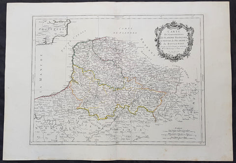
1777 F. Santini Antique Map Flanders Artois Hainaut Picardy Regions of Belgium
- Title : Carte Des Gouvernements de Flandre Francois d Artois de Picardie et du Boulenois...P Santini...1777
- Size: 30in x 21in (760mm x 535mm)
- Condition: (A+) Fine Condition
- Date : 1777
- Ref #: 50219
Description:
This large magnificent original copper-plate engraved antique map of Belgium and parts of Northern France made up of the provinces of Flanders, Artois, Hainaut, Picardy was engraved in 1777 - the date is engraved in the title cartouche - after Rigobert Bonne in 1771 and was published by Francois Santini (active 1776-84) in his 2 volume edition of Atlas Universal 1776-84.. (Ref: Tooley; M&B)
General Definitions:
Paper thickness and quality: - Heavy and stable
Paper color : - off white
Age of map color: - Original
Colors used: - Blue, pink, red, green, yellow
General color appearance: - Authentic
Paper size: - 30in x 21in (760mm x 535mm)
Plate size: - 23in x 18in (585mm x 460mm)
Margins: - Min 2in (50mm)
Imperfections:
Margins: - None
Plate area: - None
Verso: - None
Background:
Belgium officially the Kingdom of Belgium, is a country in Western Europe bordered by France, the Netherlands, Germany and Luxembourg.
Historically, Belgium was part of an area known as the Low Countries, a somewhat larger region than the current Benelux group of states that also included parts of northern France and western Germany. Its name is derived from the Latin word Belgica, after the Roman province of Gallia Belgica. From the end of the Middle Ages until the 17th century, the area of Belgium was a prosperous and cosmopolitan centre of commerce and culture. Between the 16th and early 19th centuries, Belgium served as the battleground between many European powers, earning the moniker the Battlefield of Europe, a reputation strengthened by both world wars. The country emerged in 1830 following the Belgian Revolution when it seceded from the Netherlands.
The Eighty Years War (1568–1648) divided the Low Countries into the northern United Provinces (Belgica Foederata in Latin, the Federated Netherlands) and the Southern Netherlands (Belgica Regia, the Royal Netherlands). The latter were ruled successively by the Spanish (Spanish Netherlands) and the Austrian Habsburgs (Austrian Netherlands) and comprised most of modern Belgium. This was the theatre of most Franco-Spanish and Franco-Austrian wars during the 17th and 18th centuries.
Following the campaigns of 1794 in the French Revolutionary Wars, the Low Countries—including territories that were never nominally under Habsburg rule, such as the Prince-Bishopric of Liège—were annexed by the French First Republic, ending Austrian rule in the region. The reunification of the Low Countries as the United Kingdom of the Netherlands occurred at the dissolution of the First French Empire in 1815, after the defeat of Napoleon.
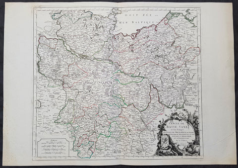
1778 Santini Antique Map Lower Saxon Circle Germany, Holstien Bremen Mecklenburg
- Title : Cercle de Basse Saxe on sont distingues Les Etats de Brunswich Les Duches De Holstien...Par L Sr Robert....A Venise...P Santini...1778
- Date : 1778
- Condition: (A+) Fine Condition
- Ref: 50203
- Size: 30in x 21in (760mm x 535mm)
Description:
This large magnificent original copper-plate engraved antique map of The Lower Saxon Circle of Northern Germany, was engraved in 1778 - the date is engraved in the title cartouche - after Robert De Vaugondy and was published by Francois Santini (active 1776-84) in his 2 volume edition of Atlas Universal 1776-84. (Ref: Tooley; M&B)
General Definitions:
Paper thickness and quality: - Heavy and stable
Paper color : - off white
Age of map color: - Original
Colors used: - Blue, pink, red, green, yellow
General color appearance: - Authentic
Paper size: - 30in x 21in (760mm x 535mm)
Plate size: - 22in x 19 1/2in (560mm x 495mm)
Margins: - Min 1in (25mm)
Imperfections:
Margins: - None
Plate area: - None
Verso: - None
Background:
The Lower Saxon Circle was an Imperial Circle of the Holy Roman Empire. It covered much of the territory of the medieval Duchy of Saxony (except for Westphalia), and was originally called the Saxon Circle (German: Sächsischer Kreis) before later being better differentiated from the Upper Saxon Circle by the more specific name.
An unusual aspect of this circle was that, at various times, the kings of Denmark (in Holstein), Great Britain (in Hanover) and Sweden (in Bremen) were all Princes of a number of Imperial States.
The Lower Saxon Circle included the easternmost part of current Lower Saxony, the northernmost part of Saxony-Anhalt (excluding the Altmark), Mecklenburg, Holstein (excluding Dithmarschen), Hamburg, Bremen, in addition to small areas in Brandenburg and Thuringia. For the most part it was a continuous territory with the exception of small enclaves like Halle and Jüterbog. Nordhausen and Mühlhausen were also areas outside the continuous portion of the imperial circle. Within the circle was the Archbishopric of Verden, which was in personal union with the Archbishopric of Bremen since 1502. The Counties of Schaumburg and Spiegelberg were also part of the personal union, but they were not a part of the Lower Saxon Circle.
By the downfall of the Holy Roman Empire, the circle was 1 240 square miles large, with 2 120 000 inhabitants. With respect to religion, almost all the citizens were Protestant. The exception was the partially Catholic Bishopric of Hildesheim.
During the Early Modern period the Holy Roman Empire was divided into Imperial Circles administrative groupings whose primary purposes were the organization of common defensive structure and the collection of imperial taxes. They were also used as a means of organization within the Imperial Diet and the Imperial Chamber Court. Each circle had a Circle Diet, although not every member of the Circle Diet would hold membership of the Imperial Diet as well.
Six Imperial Circles were introduced at the Diet of Augsburg in 1500. In 1512, three more circles were added, and the large Saxon Circle was split into two, so that from 1512 until the collapse of the Holy Roman Empire in the Napoleonic era, there were ten Imperial Circles. The Crown of Bohemia, the Swiss Confederacy and Italy remained unencircled, as did various minor territories which held imperial immediacy.
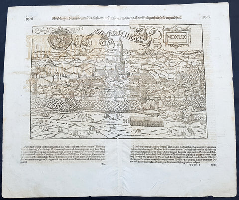
1628 Sebastian Munster & RMD Antique Map View Nordlingen Swabia, Bavaria Germany
- Title : Die Statt Nordlingen
- Ref #: 33587
- Size: 17in x 15in (435mm x 380mm)
- Date : 1628
- Condition: (A+) Fine Condition
Description:
This fine original wood block engraved antique map a birds eye view of the German town of Nördlingen in the Donau-Ries district, in Swabia, Bavaria,, was engraved by Hans Rudolf Manuel Deutsch (RMD) in 1549 - dated - and published in the German Section of Sebastian Munsters 1628 edition of Cosmographia, Das ist: Beschreibung der gantzen Welt, Darinnen Aller Monarchien Keyserthumben, Königreichen, Fürstenthumben, Graff- und Herrschafften, Länderen, Stätten und Gemeinden.Ursprung (Cosmographia, that is: description of the whole world, in it all monarchies Keyser thumben, kingdoms, prince thumben, graff and herrschafften, countries, places and municipalities.)
Hans Rudolf Manuel Deutsch (1525–1571) was a Swiss artist. He made several of the woodcuts for De re metallica (the metals and mining treatise by Georgius Agricola, the father of mineralogy) and for Sebastian Münsters Cosmographia.
Deutschs father, Niklaus Manuel Deutsch (the Elder), and Deutsch\'s brother, Niklaus Manuel Deutsch the Younger, were also artists. The elder Niklaus had taken the last name Manuel, but all three also commonly used Deutsch as part of their names and signed their paintings with initials ending in D.
Nördlingen is a town in the Donau-Ries district, in Swabia, Bavaria, Germany. The town was the location of two battles during the Thirty Years\' War, which took place between 1618–1648. Today it is one of only three towns in Germany that still has a completely established city wall, the other two being Rothenburg ob der Tauber and Dinkelsbühl.
General Definitions:
Paper thickness and quality: - Heavy and stable
Paper color : - off white
Age of map color: -
Colors used: -
General color appearance: -
Paper size: - 17in x 15in (435mm x 380mm)
Plate size: - 17in x 15in (435mm x 380mm)
Margins: - Min 1/2in (10mm)
Imperfections:
Margins: - Light offsetting
Plate area: - Light offsetting
Verso: - Light offsetting
Background:
Cosmographia, Das ist: Beschreibung der gantzen Welt, Darinnen Aller Monarchien Keyserthumben, Königreichen, Fürstenthumben, Graff- und Herrschafften, Länderen, Stätten und Gemeinden.Ursprung, Regiment, Reichthumb, Gewalt und.Beschaffenheit. Dessgleichen Aller deren, beyder Ständen, Regenten: Keysern, Königen, Bäpsten, Bischoffen.Genealogien und Stammbäumen.zusammen getragen. by Sebastian Münster was first published in 1544 and is the earliest German-language description of the world. It had numerous editions in different languages including Latin, French (translated by François de Belleforest), Italian, English, and Czech. The last German edition was published in 1628, long after Munsters death. The Cosmographia was one of the most successful and popular books of the 16th century. It passed through 24 editions in 100 years. This success was due to the notable woodcuts (some by Hans Holbein the Younger, Urs Graf, Hans Rudolph Manuel Deutsch, and David Kandel). It was most important in reviving geography in 16th-century Europe. Among the notable maps within Cosmographia is the map Tabula novarum insularum, which is credited as the first map to show the American continents as geographically discrete.
Munsters earlier geographic works were Germania descriptio (1530) and Mappa Europae (1536). In 1540, he published a Latin edition of Ptolemys Geographia with illustrations.
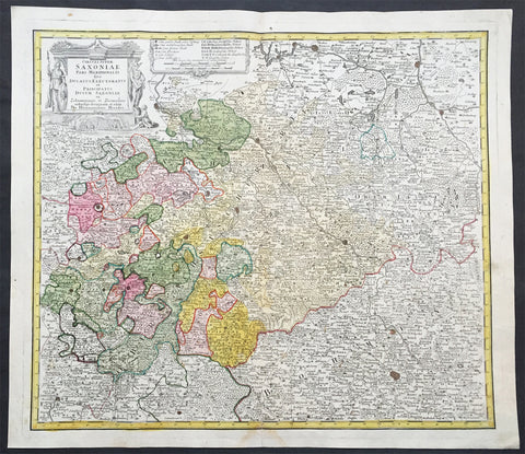
1735 J B Homann Large Antique Map of Old Saxony, Germany - Berlin to Prague
- Title : Circuli Super Saxoniae pars Meridionalis sive Ducatus...Homannianos
- Date : 1735
- Condition: (A+) Fine Condition
- Ref # : 30832
- Size : 23in x 19in (600mm x 520mm)
Description:
This large original hand coloured copper plate engraved antique map of the Saxony region of central Germany. The map stretches from Berlin in the north to Prague in the Czech Republic to the south, by J B Homann was published by the Homann Heirs firm in 1735. (Ref: Tooley; M&B)
General Definitions:
Paper thickness and quality: - Heavy and stable
Paper color : - off white
Age of map color: - Original
Colors used: - Blue, pink, red, green, yellow
General color appearance: - Authentic
Paper size: - 23in x 19in (600mm x 520mm)
Plate size: - 24in x 19 1/2in (565mm x 495mm)
Margins: - Min 1in (25mm)
Imperfections:
Margins: - None
Plate area: - None
Verso: - None
Background:
Saxony is a landlocked federal state of Germany, bordering the federal states of Brandenburg, Saxony Anhalt, Thuringia, and Bavaria, as well as the countries of Poland and the Czech Republic.
The history of the state of Saxony spans more than a millennium. It has been a medieval duchy, an electorate of the Holy Roman Empire, a kingdom, and twice a republic.
The area of the modern state of Saxony should not be confused with Old Saxony, the area inhabited by Saxons. Old Saxony corresponds roughly to the modern German states of Lower Saxony, Saxony-Anhalt, and the Westphalian part of North Rhine-Westphalia.
The territory of the Free State of Saxony became part of the Holy Roman Empire by the 10th century, when the dukes of Saxony were also kings (or emperors) of the Holy Roman Empire, comprising the Ottonian, or Saxon, Dynasty. Around this time, the Billungs, a Saxon noble family, received extensive fields in Saxony. The emperor eventually gave them the title of dukes of Saxony. After Duke Magnus died in 1106, causing the extinction of the male line of Billungs, oversight of the duchy was given to Lothar of Supplinburg, who also became emperor for a short time.
In 1137, control of Saxony passed to the Guelph dynasty, descendants of Wulfhild Billung, eldest daughter of the last Billung duke, and the daughter of Lothar of Supplinburg. In 1180 large portions west of the Weser were ceded to the Bishops of Cologne, while some central parts between the Weser and the Elbe remained with the Guelphs, becoming later the Duchy of Brunswick-Lüneburg. The remaining eastern lands, together with the title of Duke of Saxony, passed to an Ascanian dynasty (descended from Eilika Billung, Wulfhild\\\\\\\'s younger sister) and were divided in 1260 into the two small states of Saxe-Lauenburg and Saxe-Wittenberg. The former state was also named Lower Saxony, the latter Upper Saxony, thence the later names of the two Imperial Circles Saxe-Lauenburg and Saxe-Wittenberg. Both claimed the Saxon electoral privilege for themselves, but the Golden Bull of 1356 accepted only Wittenberg\\\\\\\'s claim, with Lauenburg nevertheless continuing to maintain its claim. In 1422, when the Saxon electoral line of the Ascanians became extinct, the Ascanian Eric V of Saxe-Lauenburg tried to reunite the Saxon duchies.
However, Sigismund, King of the Romans, had already granted Margrave Frederick IV the Warlike of Meissen (House of Wettin) an expectancy of the Saxon electorate in order to remunerate his military support. On 1 August 1425 Sigismund enfeoffed the Wettinian Frederick as Prince-Elector of Saxony, despite the protests of Eric V. Thus the Saxon territories remained permanently separated. The Electorate of Saxony was then merged with the much bigger Wettinian Margraviate of Meissen, however using the higher-ranking name Electorate of Saxony and even the Ascanian coat-of-arms for the entire monarchy. Thus Saxony came to include Dresden and Meissen. In the 18th and 19th centuries Saxe-Lauenburg was colloquially called the Duchy of Lauenburg, which in 1876 merged with Prussia as the Duchy of Lauenburg district.
Saxony-Wittenberg, in modern Saxony-Anhalt, became subject to the margravate of Meissen, ruled by the Wettin dynasty in 1423. This established a new and powerful state, occupying large portions of the present Free State of Saxony, Thuringia, Saxony-Anhalt and Bavaria (Coburg and its environs). Although the centre of this state was far to the southeast of the former Saxony, it came to be referred to as Upper Saxony and then simply Saxony, while the former Saxon territories were now known as Lower Saxony.
In 1485, Saxony was split. A collateral line of the Wettin princes received what later became Thuringia and founded several small states there (see Ernestine duchies). The remaining Saxon state became still more powerful and was known in the 18th century for its cultural achievements, although it was politically weaker than Prussia and Austria, states which oppressed Saxony from the north and south, respectively.
Between 1697 and 1763, the Electors of Saxony were also elected Kings of Poland in personal union.
In 1756, Saxony joined a coalition of Austria, France and Russia against Prussia. Frederick II of Prussia chose to attack preemptively and invaded Saxony in August 1756, precipitating the Third Silesian War (part of the Seven Years\\\\\\\' War). The Prussians quickly defeated Saxony and incorporated the Saxon army into the Prussian army. At the end of the Seven Years\\\\\\\' War, Saxony recovered its independence in the 1763 Treaty of Hubertusburg.
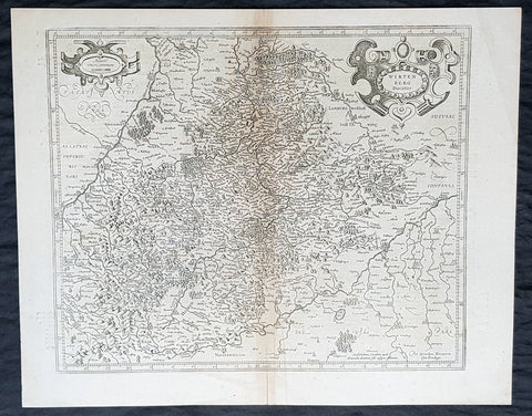
1628 Gerard Mercator & Henricus Hondius Antique Map of Duchy Wurttemberg Germany
- Title : Wirtenberg Ducatus...Per Geradum Mercatorem Cum Privilego
- Size: 21in x 17in (530mm x 430mm)
- Condition: (A+) Fine Condition
- Date : 1628
- Ref #: 26116
Description:
This original copper plate engraved antique map of Wurttemberg in todays Baden-Württemberg state in southern Germany, by Gerard Mercator was published by Henricus Hondius in the early 1628 French edition of Gerard Mercators Atlas.
These maps, published in the early editions of Mercators atlas, are the original maps drawn and engraved by Gerald Mercator in the mid to late 16th century, published by his son Rumold as an atlas, after his death, in 1595. After two editions the plates were purchased by Jodocus Hondius in 1604 and continued to be published until the mid 1630\'s when the plates were re-engraved and updated by Jan Jansson and Henricus Hondius.
General Definitions:
Paper thickness and quality: - Heavy and stable
Paper color : - off white
Age of map color: -
Colors used: -
General color appearance: -
Paper size: - 21in x 17in (530mm x 430mm)
Plate size: - 18 1/2in x 14in (475mm x 350mm)
Margins: - Min 1/2in (12mm)
Imperfections:
Margins: - Light age toning
Plate area: - Light toning along centerfold
Verso: - Light age toning
Background:
Württemberg is a historical German territory roughly corresponding to the cultural and linguistic region of Swabia. Together with Baden and Hohenzollern, two other historical territories, it now forms the Federal State of Baden-Württemberg. Württemberg was formerly also spelled Würtemberg and Wirtemberg.
The Duchy of Württemberg was a duchy located in the south-western part of the Holy Roman Empire. It was a member of the Holy Roman Empire from 1495 to 1806. The dukedoms long survival for nearly four centuries was mainly due to its size, being larger than its immediate neighbors. During the Protestant Reformation, Württemberg faced great pressure from the Holy Roman Empire to remain a member. Württemberg resisted repeated French invasions in the 17th and 18th centuries. Württemberg was directly in the path of French and Austrian armies who were engaged in the long rivalry between the House of Bourbon and the House of Habsburg. In 1803, Napoleon raised the duchy to be the Electorate of Württemberg of the Holy Roman Empire. On 1 January 1806, the last Elector assumed the title of King of Württemberg. Later this year, on 6 August 1806, the last Emperor, Francis II, abolished (de facto) the Holy Roman Empire.
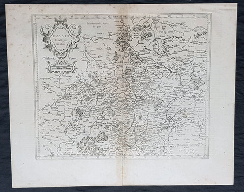
1628 Gerard Mercator & Henricus Hondius Antique Map State of Hesse, Germany
- Title : Hassia landtgrauiatus...Per Geradum Mercatorem Cum Privilego
- Size: 21in x 17in (530mm x 430mm)
- Condition: (A) Very Good Condition
- Date : 1628
- Ref #: 26107
Description:
This original copper plate engraved antique map of the State of Hesse or Hessia, in central Germany, by Gerard Mercator was published by Henricus Hondius in the early 1628 French edition of Gerard Mercators Atlas.
These maps, published in the early editions of Mercators atlas, are the original maps drawn and engraved by Gerald Mercator in the mid to late 16th century, published by his son Rumold as an atlas, after his death, in 1595. After two editions the plates were purchased by Jodocus Hondius in 1604 and continued to be published until the mid 1630s by Henricus, when some of the plates were re-engraved and updated by Jan Jansson and Henricus Hondius.
General Definitions:
Paper thickness and quality: - Heavy and stable
Paper color : - off white
Age of map color: -
Colors used: -
General color appearance: -
Paper size: - 21in x 17in (530mm x 430mm)
Plate size: - 18 1/2in x 14in (475mm x 350mm)
Margins: - Min 1/2in (12mm)
Imperfections:
Margins: - Light age toning
Plate area: - Light toning along centerfold
Verso: - Light age toning
Background:
Hesse officially the State of Hesse, is a federal state (Land) of the Federal Republic of Germany, with just over six million inhabitants. The state capital is Wiesbaden; the largest city is Frankfurt am Main.
In the 12th century, Hessengau was passed to Thuringia. In the War of the Thuringian Succession (1247–1264), Hesse gained independence and became a Landgraviate within the Holy Roman Empire. It shortly rose to primary importance under Landgrave Philip the Magnanimous, who was one of the leaders of German Protestantism. After Philips death in 1567, the territory was divided among his four sons from his first marriage (Philip was a bigamist) into four lines: Hesse-Kassel (or Hesse-Cassel), Hesse-Darmstadt, Hesse-Rheinfels, and the also previously existing Hesse-Marburg. As the latter two lines died out quite soon (1583 and 1605, respectively), Hesse-Kassel and Hesse-Darmstadt were the two core states within the Hessian lands. Several collateral lines split off during the centuries, such as in 1622, when Hesse-Homburg split off from Hesse-Darmstadt. In the late 16th century, Kassel adopted Calvinism, while Darmstadt remained Lutheran and subsequently the two lines often found themselves on different sides of a conflict, most notably in the disputes over Hesse-Marburg and in the Thirty Years War, when Darmstadt fought on the side of the Emperor, while Kassel sided with Sweden and France.
The Landgrave Frederick II (1720–1785) ruled as a benevolent despot, from 1760 to 1785. He combined Enlightenment ideas with Christian values, cameralist plans for central control of the economy, and a militaristic approach toward diplomacy.[16] He funded the depleted treasury of the poor nation by loaning 19,000 soldiers in complete military formations to Great Britain to fight in North America during the American Revolutionary War, 1776–1783. These soldiers, commonly known as Hessians, fought under the British flag. The British used the Hessians in several conflicts, including in the Irish Rebellion of 1798. For further revenue, the soldiers were loaned to other places as well. Most were conscripted, with their pay going to the Landgrave.
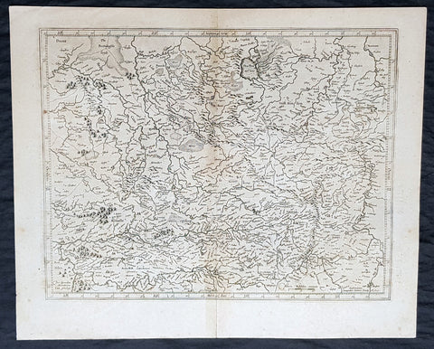
1628 Gerard Mercator & Henricus Hondius Antique Map of Westphalia, Germany
- Title : Tabula Seconde Westphalia...Per Geradum Mercatorem Cum Privilego...1627
- Size: 21in x 17in (530mm x 430mm)
- Condition: (A) Very Good Condition
- Date : 1628
- Ref #: 26109
Description:
This original copper plate engraved antique map of the Westphalia region of North Rhine-Westphalia, Germany, by Gerard Mercator was published by Henricus Hondius in the early 1628 French edition of Gerard Mercators Atlas.
These maps, published in the early editions of Mercators atlas, are the original maps drawn and engraved by Gerald Mercator in the mid to late 16th century, published by his son Rumold as an atlas, after his death, in 1595. After two editions the plates were purchased by Jodocus Hondius in 1604 and continued to be published until the mid 1630s by Henricus, when some of the plates were re-engraved and updated by Jan Jansson and Henricus Hondius.
General Definitions:
Paper thickness and quality: - Heavy and stable
Paper color : - off white
Age of map color: -
Colors used: -
General color appearance: -
Paper size: - 21in x 17in (530mm x 430mm)
Plate size: - 18 1/2in x 14in (475mm x 350mm)
Margins: - Min 1/2in (12mm)
Imperfections:
Margins: - Light age toning
Plate area: - Light toning along centerfold
Verso: - Light age toning
Background:
While the Northern Rhineland, Westphalia and Lippe are different historic territories of todays North Rhine-Westphalia, the old border between the former Rhine Province and the Province of Westphalia is also a language border. While in Westphalia and Lippe, people tend to speak West Low German dialects and especially the Westphalian variant of the Low German language, Central German and Low Franconian dialects are being spoken in the Northern Rhineland.
Westphalia is known for the 1648 Peace of Westphalia which ended the Thirty Years War, as the two treaties were signed in Münster and Osnabrück.
It is one of the regions that were part of all incarnations of the German state since the Early Middle Ages: the Holy Roman Empire, the Confederation of the Rhine, the German Confederation, the North German Confederation, the German Empire, the Weimar Republic and National Socialist Germany. After World War II it was a part of the British occupation zone which merged with the American zone to become the Bizone in 1947 and again merged with the French zone to become the Trizone in 1948. The current Federal Republic of Germany was founded on these territories making Westphalia a part of West Germany. It is a part of united Germany since 1990.
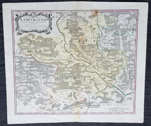
1749 Homann Antique Map Limpurg County, Schwabisch-Hall Baden-Wurtemberg Germany
- Title : Comitatus Limpurgensis Mandato Speciali imperantium mensuratus & hac Tabula geographica comprehensus / In lucem prodit Curis Homannianorum Heredum / Norimb 1749
- Date : 1749
- Condition: (A+) Fine Condition
- Ref: 20428
- Size: 23 1/2in x 20in (595mm x 510mm)
Description:
This large original copper-plate engraved antique map of Limpurg County in the district of Schwäbisch-Hallin in the state of Baden-Wurtemberg, SW Germany by the Homann Heirs was engraved in 1749 - dated in cartouche - and published in the Homanns 1750 German Atlas.
Limpurg is situated in the present-day district of Schwäbisch-Hall or Ostalbkreis between Schwäbisch-Hall, Schwäbisch Gmünd, Aalen and Ellwangen.
The map centers on the river Kocher, with towns marked such as Schwäbisch-Hall (Comburg), Gaildorf, Abstgemünd and Bühlertann.
General Definitions:
Paper thickness and quality: - Heavy and stable
Paper color : - off white
Age of map color: - Original
Colors used: - Yellow, Green, pink
General color appearance: - Authentic
Paper size: - 23 1/2in x 20in (595mm x 510mm)
Plate size: - 21in x 18in (535mm x 460mm)
Margins: - Min 1/4in (5mm)
Imperfections:
Margins: - None
Plate area: - Light soiling
Verso: - None
Background:
Baden-Württemberg is formed from the historical territories of Baden, Prussian Hohenzollern, and Württemberg, and also parts of Swabia.
In 100 AD, the Roman Empire invaded and occupied Württemberg, constructing a limes (fortified boundary zone) along its northern borders. Over the course of the third century AD, the Alemanni forced the Romans to retreat west beyond the Rhine and Danube rivers. In 496 AD the Alemanni were defeated by a Frankish invasion led by Clovis I.
The Holy Roman Empire was later established. The majority of people in this region continued to be Roman Catholics, even after the Protestant Reformation influenced populations in northern Germany. In the late-nineteenth and early-twentieth centuries, numerous people emigrated from this mostly rural area to the United States for economic reasons.
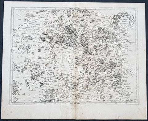
1628 Gerard Mercator Antique Map Lotharingia Region - Netherlands Germany France
- Title : Lotharingia Ducatus...Per Geradum Mercatorem Cum Privilegio
- Size: 21in x 17in (530mm x 430mm)
- Condition: (A) Very Good Condition
- Date : 1628
- Ref #: 26141
Description:
This original copper plate engraved antique map of the historical region of Lotharingia region of present-day Netherlands, Belgium, Luxembourg, North Rhine-Westphalia (Germany), Rhineland-Palatinate (Germany), Saarland (Germany), and Lorraine (France) by Gerard Mercator was published by Henricus Hondius in the early 1628 French edition of Gerard Mercators Atlas.
These maps, published in the early editions of Mercators atlas, are the original maps drawn and engraved by Gerald Mercator in the mid to late 16th century, published by his son Rumold as an atlas, after his death, in 1595. After two editions the plates were purchased by Jodocus Hondius in 1604 and continued to be published until the mid 1630\\\'s when the plates were re-engraved and updated by Jan Jansson and Henricus Hondius.
General Definitions:
Paper thickness and quality: - Heavy and stable
Paper color : - off white
Age of map color: -
Colors used: -
General color appearance: -
Paper size: - 21in x 17in (530mm x 430mm)
Plate size: - 20in x 15in (510mm x 380mm)
Margins: - Min 1/2in (12mm)
Imperfections:
Margins: - Age toning
Plate area: - Age toning
Verso: - Age toning
Lotharingia was a medieval successor kingdom of the Carolingian Empire, comprising the present-day Netherlands, Belgium, Luxembourg, North Rhine-Westphalia (Germany), Rhineland-Palatinate (Germany), Saarland (Germany), and Lorraine (France). It was named after King Lothair II who received this territory after the kingdom of Middle Francia of his father Lothair I was divided among his sons in 855.
Lotharingia was born out of the tripartite division in 855 of the kingdom of Middle Francia, which itself was formed after the threefold division of the Carolingian Empire by the Treaty of Verdun of 843. Conflict between East and West Francia over Lotharingia was based on the fact that these were the old Frankish homelands of Austrasia, so possession of them was of great prestige.

1744 Georg Mattaus Seutter Antique Map of Germany, Central & NW Europe
- Title : Imperium Romano Germanicum........a Matth. Seutteri...T C Lotter, Geogr.
- Ref #: 93398
- Size: 11in x 8 1/2in (280mm x 215mm)
- Date : 1744
- Condition: (A+) Fine Condition
Description:
This beautifully hand coloured original copper-plate engraved antique map of Germany and NW Europe was engraved by Tobias Lotter and was published in the 1744 edition of GM Seutters Atlas Minor Prae cipua Orbis Terrarum Imperia Regna et Provincias...., Augsburg, Germany.
General Definitions:
Paper thickness and quality: - Heavy and stable
Paper color : - off white
Age of map color: - Original
Colors used: - Yellow, green, blue, pink
General color appearance: - Authentic
Paper size: - 11in x 8 1/2in (280mm x 215mm)
Plate size: - 10 1/2in x 8in (265mm x 205mm)
Margins: - Min 1/4in (5mm)
Imperfections:
Margins: - Light age toning
Plate area: - Light age toning
Verso: - None
Background:
Atlas Minor was a series of beautiful maps of all parts of the world. Georg Matthäus Seutter was one of the most and important of the German cartographers of the 18th century, being appointed as the Geographer to the Imperial Court. His son, Albrecht Carl, joined Matthäus and eventually inherited the business. The maps from Atlas Minor were drawn by the two Seutters and engraved by Tobias Conrad Lotte. These maps are highly detailed and engraved with a bold hand with equally strong original hand color in the body of the map as was the 18th century German style. The cartouches were left uncolored in order to emphasize the elaborately detailed illustrations for which German maps are especially prized. These are some of the most decorative and interesting maps of the eighteenth century.
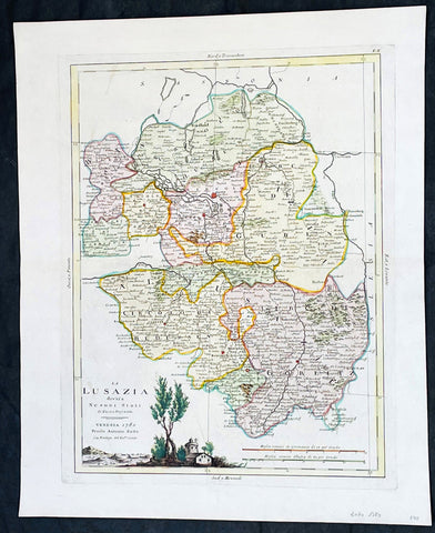
1780 Antonio Zatta Antique Map of The Lusatia Region Germany, Poland & Czech Rep
- Title : La Lusazia divisa ne suoi stati di nuova projezione
- Ref #: 35638
-
Condition: (A+) Fine Condition
- Size: 19in x 15 1/2in (485mm x 395mm)
- Date : 1780
- Price: $149US
Description:
This original hand coloured copper plate engraved antique map of the ancient central European region of Lusatia in between Poland and Germany, and in the south, the Czech Republic by Antonio Zatta (fl. 1775-97) in 1780 - dated - was published in his Atlas Atlante Novissimo
General Definitions:
Paper thickness and quality: - Heavy and stable
Paper color : - off white
Age of map color: - Original
Colors used: - Yellow, green, blue, pink
General color appearance: - Authentic
Paper size: - 19in x 15 1/2in (485mm x 395mm)
Plate size: - 16in x 12 1/2in (405mm x 315mm)
Margins: - Min 1in (25mm)
Imperfections:
Margins: - None
Plate area: - None
Verso: - None
Background:
Lusatia is a historical region in Central Europe, split between Germany and Poland. Lusatia stretches from the Bóbr and Kwisa rivers in the east to the Pulsnitz and Black Elster rivers in the west, and is located within the German states of Saxony and Brandenburg as well as in the Polish voivodeships of Lower Silesia and Lubusz. Lusatia's central rivers are the Spree and the Lusatian Neisse, which constitutes the border between Germany and Poland since 1945 (Oder–Neisse line). The Lusatian Mountains (part of the Sudetes), separate Lusatia from Bohemia (Czech Republic) in the south. Lusatia is traditionally divided into Upper Lusatia (the hilly southern part) and Lower Lusatia (the flat northern part).
Please note all items auctioned are genuine, we do not sell reproductions. A Certificate of Authenticity (COA) can be issued on request.
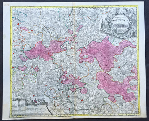
1756 Lotter Large Antique Map of Rhine Koblenz, Germany
- Title : Archiepiscopatus et Electoratus Moguntinus...
- Ref #: 50169
- Size: 25in x 20in (635mm x 510mm)
- Date : 1756
- Condition: (A+) Fine Condition
Description:
This large beautiful hand coloured original antique map of the Rhine River region of central western Germany was engraved by Tobias Conrad Lotter in 1756.
The map centres on the city of Frankfurt stretches along the Rhine River from Koblenz in the North to Speir in the South. Wertheim in the east to Kern in the west (Ref: Tooley, M&B)
General Description:
Paper thickness and quality: - Heavy and stable
Paper color: - off white
Age of map color: - Original
Colors used: - Pink, green, yellow, blue
General color appearance: - Authentic
Paper size: - 25in x 20in (635mm x 510mm)
Plate size: - 22 ½in x 19 ½in (570mm x 495mm)
Margins: - Min 1/2in (12mm)
Imperfections:
Margins: - None
Plate area: - None
Verso: - None
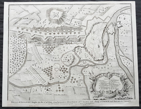
1745 Nicolas Tindal Large Antique Map The Battle of Schellenberg, Germany 1704
- Title : Battle of Donawert fought on the 2nd of June 1704 between a detachment of ye Allies and a body of French and Bavarian Troops
- Size: 20in x 16in (510mm x 410mm)
- Condition: (A+) Fine Condition
- Date : 1745
- Ref #: 22160
Description:
This large original antique copper-plate engraved military map of the Battle of Schellenberg, also known as the Battle of Donauwörth in the Donau-Ries district of Swabia, in Bavaria, Germany - during the Spanish War of Succession - was engraved by John Basire and published in the 1745 edition of Nicholas Tindals Continuation of Mr. Rapins History of England.
General Definitions:
Paper thickness and quality: - Heavy and stable
Paper color : - off white
Age of map color: -
Colors used: -
General color appearance: -
Paper size: - 20in x 16in (510mm x 410mm)
Plate size: - 20in x 16in (510mm x 410mm)
Margins: - Min 1/2in (10mm)
Imperfections:
Margins: - None
Plate area: - Folds as issued
Verso: - None
The Battle of Schellenberg, also known as the Battle of Donauwörth, was fought on 2 July 1704 during the War of the Spanish Succession. The engagement was part of the Duke of Marlboroughs campaign to save the Habsburg capital of Vienna from a threatened advance by King Louis XIVs Franco-Bavarian forces ranged in southern Germany. Marlborough had commenced his 400 km march from Bedburg, near Cologne, on 19 May; within five weeks he had linked his forces with those of the Margrave of Baden, before continuing on to the river Danube. Once in southern Germany, the Allies task was to induce Max Emanuel, the Elector of Bavaria, to abandon his allegiance to Louis XIV and rejoin the Grand Alliance; but to force the issue, the Allies first needed to secure a fortified bridgehead and magazine on the Danube, through which their supplies could cross to the south of the river into the heart of the Electors lands. For this purpose, Marlborough selected the town of Donauwörth.
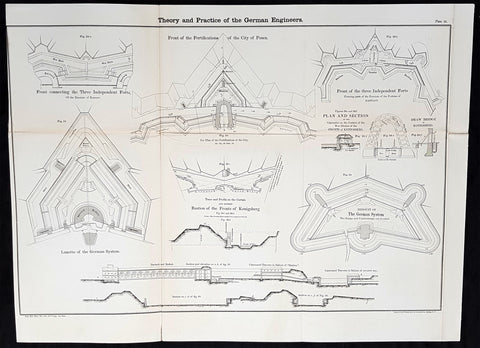
1856 Cap Richard Delafield Large Antique Schematics German Fortifications
- Title : Theory and Practise of the German Engineers
- Date : 1856
- Condition: (A+) Fine Condition
- Ref: 90144
- Size: 24 1/2in x 18in (615mm x 475mm)
Description:
This large original lithograph print, schematics of parts of the German Forts in such cities as Coblenz, Posen, Mainz, Luxemburg, Landau & others - during the time of the Crimean War - was engraved by John T Bowen & co. of Philadelphia and was published in the 1856 edition of Captain Richard Delafields Report on the Art of War in Europe in 1854, 1855, and 1856.
In early 1855, Captain Richard Delafield was appointed by the Secretary of War, Jefferson Davis, a head of the board of officers, later called The Delafield Commission, and sent to Europe to study the European military. The board included Captain George B. McClellan and Major Alfred Mordecai. They inspected the state of the military in Great Britain, Germany, the Austrian Empire, France, Belgium, and Russia, and served as military observers during the Crimean War. After his return in April 1856, Delafield submitted a report which was later published as a book by Congress, Report on the Art of War in Europe in 1854, 1855, and 1856. The book was suppressed during the American Civil War due to fears that it would be instructive to Confederate engineers as it contained multiple drawings and descriptions of military fortifications.
General Definitions:
Paper thickness and quality: - Light and stable
Paper color : - off white
Age of map color: -
Colors used: -
General color appearance: -
Paper size: - 24 1/2in x 18in (615mm x 475mm)
Plate size: - 24 1/2in x 18in (615mm x 475mm)
Margins: - Min 1/2in (12mm)
Imperfections:
Margins: - None
Plate area: - Light age toning along folds, as issued
Verso: - Folds re-enforced with archival tape
Background:
Under the term of the 1815 Peace of Paris, France was obliged to pay for the construction of a line of fortresses to protect the German Confederation against any future aggression by France. All fortresses were located outside Austria and Prussia — the two biggest, bickering powers of the Confederation.
Section C. Defensive System of the Germanic Confederation of the protocol drawn up at Paris on 3 November 1815, declared Mainz, Luxemburg, and Landau to be fortresses belonging to the Confederation of Germany, and stipulated that a fourth should be constructed on the Upper Rhine. In conformity with this act, a portion of the funds, which France was compelled to pay by way of indemnity for the cost of placing her on a peaceable footing, was thus appropriated: £200,000 were set aside for completing the works at Mainz; £800,000 were assigned to Prussia, to be applied upon its fortresses on the Lower Rhine; another £800,000 were reserved for constructing the new federal fortress on the Upper Rhine; and Bavaria was allowed £600,000 towards erecting another strong place on the Rhine, at Germersheim or some other point.
By 1835 the works about Mainz were completed; the twin fortresses of Koblenz and Ehrenbreitstein, and Cologne had been abundantly strengthened on the side of Prussia; and, on the Bavarian side, the fortress of Germersheim was in a state to defend the passage on the Upper Rhine. The western frontier of Germany had, in this way, been provided with a formidable line of defences against possible hostile actions by their neighbours. The eastern side of Germany has been additionally fortified by the erection of a strong citadel at Posen; and the southern was to be still further protected by the formidable works in course of construction at Brixen in the Tyrol.
The fortress of Ulm became a major strategic fortress able to accommodate 100,000 men and their equipment. Since the Kingdom of Württemberg had no engineering corps King William I appointed Moritz Karl Ernst von Prittwitz, a Prussian major, as the supervisor to oversee the building the fortresses. His plans included the provisions for the prospective development of the city Ulm. Major Theodor von Hildebrandt was appointed to oversee the building of fortresses around Neu-Ulm on the Bavarian side of the Danube
Delafield, Richard Major General 1798 - 1873 - Delafield was a United States Army officer for 52 years. He served as superintendent of the United States Military Academy for 12 years. At the start of the American Civil War, then Colonel Delafield helped equip and send volunteers from New York to the Union Army. He also was in command of defences around New York harbor from 1861 to April 1864. On April 22, 1864, he was promoted to Brigadier General in the Regular Army of the United States and Chief of Engineers. On March 8, 1866, President Andrew Johnson nominated Delafield for appointment to the grade of brevet major general in the Regular Army, to rank from March 13, 1865, and the United States Senate confirmed the appointment on May 4, 1866, reconfirmed due to a technicality on July 14, 1866. He retired from the US Army on August 8, 1866. He later served on two commissions relating to improvements to Boston Harbor and to lighthouses. He also served as a regent of the Smithsonian Institution.
Delafield served as assistant engineer in the construction of Hampton Roads defences from 1819–1824 and was in charge of fortifications and surveys in the Mississippi River delta area in 1824-1832. While superintendent of repair work on the Cumberland Road east of the Ohio River, he designed and built Dunlaps Creek Bridge in Brownsville, Pennsylvania, the first cast-iron tubular-arch bridge in the United States. Commissioned a major of engineers in July 1838, he was appointed superintendent of the Military Academy after the fire of 1838 and served till 1845. He designed the new buildings and the new cadet uniform that first displayed the castle insignia. He superintended the construction of coast defences for New York Harbor from 1846 to 1855.
In the beginning of 1855, Delafield was appointed by the Secretary of War, Jefferson Davis a head of the board of officers, later called The Delafield Commission, and sent to Europe to study the European military. The board included Captain George B. McClellan and Major Alfred Mordecai. They inspected the state of the military in Great Britain, Germany, the Austrian Empire, France, Belgium, and Russia, and served as military observers during the Crimean War. After his return in April 1856, Delafield submitted a report which was later published as a book by Congress, Report on the Art of War in Europe in 1854, 1855, and 1856. The book was suppressed during the American Civil War due to fears that it would be instructive to Confederate engineers as it contained multiple drawings and descriptions of military fortifications.
Delafield served as superintendent of the Military Academy again in 1856-1861. In January 1861, he was succeeded by Captain Pierre G. T. Beauregard, who was dismissed shortly after Beauregards home state of Louisiana seceded from the Union, and Delafield returned as superintendent serving until March 1, 1861. In the beginning of the Civil War he advised the governor of New York Edwin D. Morgan during the volunteer force creation. Then, in 1861–1864, he was put in charge of New York Harbor defences, including Governors Island and Fort at Sandy Hook. On May 19, 1864, he was commissioned a brigadier-general after replacing Joseph Gilbert Totten, who had died, as the Chief of Engineers, United States Army Corps of Engineers, on April 22, 1864. He stayed in charge of the Bureau of Engineers of the War Department until his retirement on August 8, 1866. On March 8, 1866, President Andrew Johnson nominated Delafield for appointment to the grade of brevet major general in the Regular Army of the United States, to rank from March 13, 1865, and the United States Senate confirmed the appointment on May 4, 1866 and reconfirmed it due to a technicality on July 14, 1866.After retirement Delafield served as a regent of the Smithsonian Institution and a member of the Lighthouse Board. He died in Washington, D.C. on November 5, 1873.
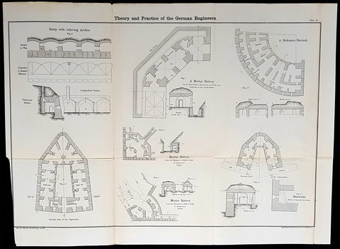
1856 Cap Richard Delafield Large Antique Schematics German Fortifications
- Title : Theory and Practise of the German Engineers
- Condition: (A+) Fine Condition
- Ref: 90194
- Size: 24 1/2in x 18in (615mm x 475mm)
Description:
This large original lithograph print, schematics of parts of the German Forts in such cities as Coblenz, Posen, Mainz, Luxemburg, Landau & others - during the time of the Crimean War - was engraved by John T Bowen & co. of Philadelphia and was published in the 1856 edition of Captain Richard Delafields Report on the Art of War in Europe in 1854, 1855, and 1856.
In early 1855, Captain Richard Delafield was appointed by the Secretary of War, Jefferson Davis, a head of the board of officers, later called The Delafield Commission, and sent to Europe to study the European military. The board included Captain George B. McClellan and Major Alfred Mordecai. They inspected the state of the military in Great Britain, Germany, the Austrian Empire, France, Belgium, and Russia, and served as military observers during the Crimean War. After his return in April 1856, Delafield submitted a report which was later published as a book by Congress, Report on the Art of War in Europe in 1854, 1855, and 1856. The book was suppressed during the American Civil War due to fears that it would be instructive to Confederate engineers as it contained multiple drawings and descriptions of military fortifications.
General Definitions:
Paper thickness and quality: - Light and stable
Paper color : - off white
Age of map color: -
Colors used: -
General color appearance: -
Paper size: - 24 1/2in x 18in (615mm x 475mm)
Plate size: - 24 1/2in x 18in (615mm x 475mm)
Margins: - Min 1/2in (12mm)
Imperfections:
Margins: - None
Plate area: - Folds as issued
Verso: - Folds re-enforced with archival tape
Background:
Under the term of the 1815 Peace of Paris, France was obliged to pay for the construction of a line of fortresses to protect the German Confederation against any future aggression by France. All fortresses were located outside Austria and Prussia — the two biggest, bickering powers of the Confederation.
Section C. Defensive System of the Germanic Confederation of the protocol drawn up at Paris on 3 November 1815, declared Mainz, Luxemburg, and Landau to be fortresses belonging to the Confederation of Germany, and stipulated that a fourth should be constructed on the Upper Rhine. In conformity with this act, a portion of the funds, which France was compelled to pay by way of indemnity for the cost of placing her on a peaceable footing, was thus appropriated: £200,000 were set aside for completing the works at Mainz; £800,000 were assigned to Prussia, to be applied upon its fortresses on the Lower Rhine; another £800,000 were reserved for constructing the new federal fortress on the Upper Rhine; and Bavaria was allowed £600,000 towards erecting another strong place on the Rhine, at Germersheim or some other point.
By 1835 the works about Mainz were completed; the twin fortresses of Koblenz and Ehrenbreitstein, and Cologne had been abundantly strengthened on the side of Prussia; and, on the Bavarian side, the fortress of Germersheim was in a state to defend the passage on the Upper Rhine. The western frontier of Germany had, in this way, been provided with a formidable line of defences against possible hostile actions by their neighbours. The eastern side of Germany has been additionally fortified by the erection of a strong citadel at Posen; and the southern was to be still further protected by the formidable works in course of construction at Brixen in the Tyrol.
The fortress of Ulm became a major strategic fortress able to accommodate 100,000 men and their equipment. Since the Kingdom of Württemberg had no engineering corps King William I appointed Moritz Karl Ernst von Prittwitz, a Prussian major, as the supervisor to oversee the building the fortresses. His plans included the provisions for the prospective development of the city Ulm. Major Theodor von Hildebrandt was appointed to oversee the building of fortresses around Neu-Ulm on the Bavarian side of the Danube.
Delafield, Richard Major General 1798 - 1873
Delafield was a United States Army officer for 52 years. He served as superintendent of the United States Military Academy for 12 years. At the start of the American Civil War, then Colonel Delafield helped equip and send volunteers from New York to the Union Army. He also was in command of defences around New York harbor from 1861 to April 1864. On April 22, 1864, he was promoted to Brigadier General in the Regular Army of the United States and Chief of Engineers. On March 8, 1866, President Andrew Johnson nominated Delafield for appointment to the grade of brevet major general in the Regular Army, to rank from March 13, 1865, and the United States Senate confirmed the appointment on May 4, 1866, reconfirmed due to a technicality on July 14, 1866. He retired from the US Army on August 8, 1866. He later served on two commissions relating to improvements to Boston Harbor and to lighthouses. He also served as a regent of the Smithsonian Institution.
Delafield served as assistant engineer in the construction of Hampton Roads defences from 1819–1824 and was in charge of fortifications and surveys in the Mississippi River delta area in 1824-1832. While superintendent of repair work on the Cumberland Road east of the Ohio River, he designed and built Dunlaps Creek Bridge in Brownsville, Pennsylvania, the first cast-iron tubular-arch bridge in the United States. Commissioned a major of engineers in July 1838, he was appointed superintendent of the Military Academy after the fire of 1838 and served till 1845. He designed the new buildings and the new cadet uniform that first displayed the castle insignia. He superintended the construction of coast defences for New York Harbor from 1846 to 1855.
In the beginning of 1855, Delafield was appointed by the Secretary of War, Jefferson Davis a head of the board of officers, later called The Delafield Commission, and sent to Europe to study the European military. The board included Captain George B. McClellan and Major Alfred Mordecai. They inspected the state of the military in Great Britain, Germany, the Austrian Empire, France, Belgium, and Russia, and served as military observers during the Crimean War. After his return in April 1856, Delafield submitted a report which was later published as a book by Congress, Report on the Art of War in Europe in 1854, 1855, and 1856. The book was suppressed during the American Civil War due to fears that it would be instructive to Confederate engineers as it contained multiple drawings and descriptions of military fortifications.
Delafield served as superintendent of the Military Academy again in 1856-1861. In January 1861, he was succeeded by Captain Pierre G. T. Beauregard, who was dismissed shortly after Beauregards home state of Louisiana seceded from the Union, and Delafield returned as superintendent serving until March 1, 1861. In the beginning of the Civil War he advised the governor of New York Edwin D. Morgan during the volunteer force creation. Then, in 1861–1864, he was put in charge of New York Harbor defences, including Governors Island and Fort at Sandy Hook. On May 19, 1864, he was commissioned a brigadier-general after replacing Joseph Gilbert Totten, who had died, as the Chief of Engineers, United States Army Corps of Engineers, on April 22, 1864. He stayed in charge of the Bureau of Engineers of the War Department until his retirement on August 8, 1866. On March 8, 1866, President Andrew Johnson nominated Delafield for appointment to the grade of brevet major general in the Regular Army of the United States, to rank from March 13, 1865, and the United States Senate confirmed the appointment on May 4, 1866 and reconfirmed it due to a technicality on July 14, 1866.After retirement Delafield served as a regent of the Smithsonian Institution and a member of the Lighthouse Board. He died in Washington, D.C. on November 5, 1873.
1791 J B Elwe Antique Map of Upper & Lower Silesia Poland Germany Czech Republic
- Title : Kaarteje Van Het Hertogdom Silesia
- Ref #: 35635
-
Condition: (A+) Fine Condition
- Size: 10 1/2in x 8in (265mm x 205mm)
- Date : 1791
- Price: $149US
Description:
This original hand coloured copper plate engraved antique map of Upper and Lower Silesia, with an inset map of the city of Breslau was engraved by G. Delisle for JB Elwe & D M Langeveld in 1791.
General Definitions:
Paper thickness and quality: - Heavy and stable
Paper color : - off white
Age of map color: - Original
Colors used: - Yellow, green, blue, pink
General color appearance: - Authentic
Paper size: - 10 1/2in x 8in (265mm x 205mm)
Plate size: - 10in x 7in (255mm x 180mm)
Margins: - Min 1/2in (12mm)
Imperfections:
Margins: - None
Plate area: - None
Verso: - None
Background:
Silesia is a historical region located in Central Europe, primarily encompassing areas that are now part of modern-day Poland, Germany, and the Czech Republic. Its history is complex and marked by various political and cultural shifts. Here is a concise overview of the history of Silesia:
Ancient and Medieval Periods:
The region of Silesia was inhabited by various tribes, including the Celts and later the Germanic tribes.
In the 9th century, the area came under the control of the emerging Polish state.
The region witnessed territorial conflicts between Poland, Bohemia (part of the Holy Roman Empire), and other neighboring powers throughout the medieval period.
Bohemian and Habsburg Rule:
In the 14th century, the Kingdom of Bohemia gained control over most of Silesia.
Silesia became part of the Habsburg Monarchy in the 16th century after the House of Habsburg inherited the Bohemian crown.
The Habsburgs ruled over Silesia for several centuries, during which the region experienced economic growth and cultural development.
Prussian and German Influence:
Following the War of the Austrian Succession (1740-1748), the Kingdom of Prussia, led by Frederick the Great, gained control of a significant portion of Silesia.
Prussia's annexation of Silesia sparked conflicts with Austria and contributed to the broader geopolitical tensions in Europe.
Silesia became an integral part of Prussia and later the German Empire, experiencing industrialization and urbanization during the 19th and early 20th centuries.
Post-World War I and World War II:
After Germany's defeat in World War I, the Treaty of Versailles (1919) redrew the borders of Europe, and the majority of Silesia was incorporated into the newly reestablished Poland.
The region witnessed significant ethnic and political tensions between its German and Polish populations.
Following World War II, the Potsdam Conference (1945) awarded most of Silesia to Poland, resulting in the expulsion of the German population and the resettlement of Poles.
Modern Period:
Since the end of World War II, Silesia has remained divided between Poland, Germany, and the Czech Republic.
The Polish part of Silesia, known as Upper Silesia, has become an important industrial and mining region.
The German and Czech parts of Silesia have experienced economic growth and cultural revitalization, with efforts to preserve the region's heritage.
Today, Silesia serves as a symbol of shared history and cultural diversity, with each country that possesses parts of the region contributing to its unique identity.
Elwe, J B
Johann Balthasar Probst, known as J.B. Elwe, was a German publisher and map seller who operated during the late 18th century. He was born in Nuremberg, Germany, in 1727 and later moved to Amsterdam, Netherlands, where he established himself as a prominent cartographer and publisher.
Elwe is known for publishing and distributing maps, atlases, and geographical works, including reprints and editions of earlier cartographic works by notable mapmakers such as Gerard Mercator, Abraham Ortelius, and Jodocus Hondius. He also produced his own maps and atlases, often based on the latest geographic knowledge of the time.
Elwe's publications were known for their decorative elements, including elaborate title cartouches, ornate borders, and vibrant hand coloring. His maps covered various regions, including Europe, Africa, Asia, and the Americas.
J.B. Elwe's cartographic business flourished during the late 18th century, and he gained a reputation for the quality and aesthetic appeal of his maps. However, precise details about his personal life and the extent of his contributions to cartography are not widely available.
Please note all items auctioned are genuine, we do not sell reproductions. A Certificate of Authenticity (COA) can be issued on request.
1740 Isaac Tirion Antique Map of Bohemia, Silesia, Moravia - Germany, Poland
- Title : Nuova Carta del Regno di Boemia Ducato Di Slesia, Marches Ato Di Moravia e lusazia in Amsterdam da Isac Tirion
- Ref #: 35636
-
Condition: (A+) Fine Condition
- Size: 14 1/2in x 12 1/2in (365mm x 315mm)
- Date : 1740
- Price: $149US
Description:
This original hand coloured copper plate engraved antique map of the central European countries of the Kingdom of Bohemia, Duchy of Silesia, Marquisate of Moravia, and Lusatia by Isaac Tirion, was published in 1740 in Amsterdam.
General Definitions:
Paper thickness and quality: - Heavy and stable
Paper color : - off white
Age of map color: - Original
Colors used: - Yellow, green, blue, pink
General color appearance: - Authentic
Paper size: - 14 1/2in x 12 1/2in (365mm x 315mm)
Plate size: - 12 1/2in x 10 1/2in (315mm x 265mm)
Margins: - Min 1in (25mm)
Imperfections:
Margins: - None
Plate area: - None
Verso: - None
Background:
Bohemia is the westernmost and largest historical region of the Czech Republic. Bohemia can also refer to a wider area consisting of the historical Lands of the Bohemian Crown ruled by the Bohemian kings, including Moravia and Czech Silesia, in which case the smaller region is referred to as Bohemia proper as a means of distinction
Please note all items auctioned are genuine, we do not sell reproductions. A Certificate of Authenticity (COA) can be issued on request.
1574 Munster Large Antique Print - View of The German City of Landau, Bavaria
- Title : Die Statt Landaw
- Ref #: 22668
- Size: 16in x 13in (410mm x 330mm)
- Date : 1574
- Condition: (A+) Fine Condition
Description:
This large finely engraved original antique print a view of the Bavarian City of Landau NE of Munich was engraved in 1547 - the date is engraved at the foot of the image - and was published by Sebastian Munster in the 1574 edition of Cosmographia.
Landau or Landau in der Pfalz (pop. 41,821) is an autonomous (kreisfrei) city surrounded by the Südliche Weinstraße ("Southern Wine Route") district of southern Rhineland-Palatinate, Germany. It is a university town (since 1990), a long-standing cultural centre, and a market and shopping town, surrounded by vineyards and wine-growing villages of the Palatinate wine region. Landau lies east of the Palatinate forest, Europe's largest contiguous forest, direct on the German Wine Route.
Background: For a variety of reasons town plans were comparatively latecomers in the long history of cartography. Few cities in Europe in the middle ages had more than 20,00 inhabitants and even London in the late Elizabethan period had only 100-150,000 people which in itself was probably 10 times that of any other English city. The Nuremberg Chronicle in 1493 included one of the first town views of Jerusalem, thereafter, for most of the sixteenth century, German cartographers led the way in producing town plans in a modern sense. In 1544 Sebastian Munster issued in Basle hisCosmographia containing roughly sixty-six plans and views, some in the plan form, but many in the old panorama or birds eye view.
Sebastian Münster (1488-1552) was a German cartographer, cosmographer, and Hebrew scholar whose work Cosmographia (1544; "Cosmography") was the earliest German description of the world and a major work in the revival of geographic thought in 16th-century Europe. It had numerous editions in different languages including Latin, French, Italian, English, and even Czech. Altogether, about 40 editions of the Cosmographiaappeared between 1544 and 1628 and was one of the most successful and popular books of the 16th century. Münster was a major influence in popular thinking in Europe for the next 200 years.
This success was due not only to the level of descriptive detail but also to the fascinating full page maps & views as well as smaller woodcuts that were included in the text. Many of the woodcuts were executed by famous engravers of the time including Hans Holbein the Younger, Urs Graf, Hans Rudolph Manuel Deutsch, and David Kandel.
Aside from the well-known maps present in the Cosmographia, the text is thickly sprinkled with vigorous views: portraits of kings and princes, costumes and occupations, habits and customs, flora and fauna, monsters, wonders, and horrors about the known -- and unknown -- world, and was undoubtedly one of the most widely read books of its time.
Münster acquired the material for his book in three ways. Firstly he researched all available literary sources across Germany, Switzerland and other parts of Europe. Secondly he obtained original manuscript material from locals all over Europe for description of the countryside, cities, villages, towns, rivers and local history. Finally, he obtained further material first hand on his travels (primarily in south-west Germany, Switzerland, and Alsace).
In 1588 Sebastian Petri re-released Cosomgraphia and re-issued many of Munsters maps and views in the "copperplate style". The maps in this release were more sophisticated than with earlier publications ofCosomgraphia and were based on the 1570 release of Abraham Ortelius monumental work Theatrum Orbis Terrarum.(Ref: Tooley; M&B)
General Description:
Paper thickness and quality: - Light and stable
Paper color: - off white
Age of map color: -
Colors used: -
General color appearance: -
Paper size: - 16in x 13in (410mm x 330mm)
Plate size: - 16in x 13in (410mm x 330mm)
Margins: - 1/2in (12mm)
Imperfections:
Margins: - None
Plate area: -None
Verso: - None
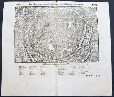
1598 Sebastian Munster Antique Map View of Freiberg, Saxony Southern Germany
- Title : Die Statt Freyberg
- Date : 1598
- Size: 15in x 13in (380mm x 330mm)
- Ref #: 30329
- Condition: (A+) Fine Condition
Description:
This large finely engraved original antique print a view of the German City of Freiberg, Saxony was published by Sebastian Munster in the 1598 edition of Cosmographia.
Freiberg (German for "free for mining activities") is a university and mining town in the Free State of Saxony, Germany. It is a so-called Große Kreisstadt (large county town) and the administrative centre of Mittelsachsendistrict.
Background:
For a variety of reasons town plans were comparatively latecomers in the long history of cartography. Few cities in Europe in the middle ages had more than 20,00 inhabitants and even London in the late Elizabethan period had only 100-150,000 people which in itself was probably 10 times that of any other English city. The Nuremberg Chronicle in 1493 included one of the first town views of Jerusalem, thereafter, for most of the sixteenth century, German cartographers led the way in producing town plans in a modern sense. In 1544 Sebastian Munster issued in Basle his Cosmographia containing roughly sixty-six plans and views, some in the plan form, but many in the old panorama or birds eye view.
General Definitions:
Paper thickness and quality: - Heavy and stable
Paper color : - off white
Age of map color: -
Colors used: -
General color appearance: -
Paper size: - 15in x 13in (380mm x 330mm)
Plate size: - 15in x 13in (380mm x 330mm)
Margins: - Min 1/2in (12mm)
Imperfections:
Margins: - None
Plate area: - Light age toning along centerfold
Verso: - Light age toning along centerfold
1757 Robert De Vaugondy Large Antique Map of Saxony, Meissen, Thuringia, Leipzig
- Title : Partie Meridionale Du Cercle De Haute Saxe...Par Le Sr. Robert
- Size: 26in x 20in (660mm x 510mm)
- Condition: (A+) Fine Condition
- Date : 1757
- Ref #: 41573
Description:
This large magnificent hand coloured original copper-plate engraved antique map of part of the Saxony region of Germany, centering on the district of Meissen & Thuringia and the city of Leipzig, by Robert De Vaugondy was published in the 1757 edition of De Vaugondys famous The Atlas Universel
General Definitions:
Paper thickness and quality: - Heavy and stable
Paper color : - off white
Age of map color: - Original & later
Colors used: - Blue, pink, red, green, yellow
General color appearance: - Authentic
Paper size: - 26in x 20in (660mm x 510mm)
Plate size: - 22in x 19 1/2in (560mm x 495mm)
Margins: - Min 1/2in (10mm)
Imperfections:
Margins: - None
Plate area: - None
Verso: - None
Background:
Saxony is a landlocked federal state of Germany, bordering the federal states of Brandenburg, Saxony Anhalt, Thuringia, and Bavaria, as well as the countries of Poland and the Czech Republic. Its capital is Dresden, and its largest city is Leipzig.
Saxony is the 10th-largest of Germany\'s 16 states, with an area of 18,413 square kilometres (7,109 sq mi), and the sixth-most populous, with 4 million people.
The history of the state of Saxony spans more than a millennium. It has been a medieval duchy, an electorate of the Holy Roman Empire, a kingdom, and twice a republic.
The area of the modern state of Saxony should not be confused with Old Saxony, the area inhabited by Saxons. Old Saxony corresponds roughly to the modern German states of Lower Saxony, Saxony-Anhalt, and the Westphalian part of North Rhine-Westphalia.
The territory of the Free State of Saxony became part of the Holy Roman Empire by the 10th century, when the dukes of Saxony were also kings (or emperors) of the Holy Roman Empire, comprising the Ottonian, or Saxon, Dynasty. Around this time, the Billungs, a Saxon noble family, received extensive fields in Saxony. The emperor eventually gave them the title of dukes of Saxony. After Duke Magnus died in 1106, causing the extinction of the male line of Billungs, oversight of the duchy was given to Lothar of Supplinburg, who also became emperor for a short time.
In 1137, control of Saxony passed to the Guelph dynasty, descendants of Wulfhild Billung, eldest daughter of the last Billung duke, and the daughter of Lothar of Supplinburg. In 1180 large portions west of the Weser were ceded to the Bishops of Cologne, while some central parts between the Weser and the Elbe remained with the Guelphs, becoming later the Duchy of Brunswick-Lüneburg. The remaining eastern lands, together with the title of Duke of Saxony, passed to an Ascanian dynasty (descended from Eilika Billung, Wulfhild\'s younger sister) and were divided in 1260 into the two small states of Saxe-Lauenburg and Saxe-Wittenberg. The former state was also named Lower Saxony, the latter Upper Saxony, thence the later names of the two Imperial Circles Saxe-Lauenburg and Saxe-Wittenberg. Both claimed the Saxon electoral privilege for themselves, but the Golden Bull of 1356 accepted only Wittenberg\'s claim, with Lauenburg nevertheless continuing to maintain its claim. In 1422, when the Saxon electoral line of the Ascanians became extinct, the Ascanian Eric V of Saxe-Lauenburg tried to reunite the Saxon duchies.
However, Sigismund, King of the Romans, had already granted Margrave Frederick IV the Warlike of Meissen (House of Wettin) an expectancy of the Saxon electorate in order to remunerate his military support. On 1 August 1425 Sigismund enfeoffed the Wettinian Frederick as Prince-Elector of Saxony, despite the protests of Eric V. Thus the Saxon territories remained permanently separated. The Electorate of Saxony was then merged with the much bigger Wettinian Margraviate of Meissen, however using the higher-ranking name Electorate of Saxony and even the Ascanian coat-of-arms for the entire monarchy. Thus Saxony came to include Dresden and Meissen. In the 18th and 19th centuries Saxe-Lauenburg was colloquially called the Duchy of Lauenburg, which in 1876 merged with Prussia as the Duchy of Lauenburg district.
Saxony-Wittenberg, in modern Saxony-Anhalt, became subject to the margravate of Meissen, ruled by the Wettin dynasty in 1423. This established a new and powerful state, occupying large portions of the present Free State of Saxony, Thuringia, Saxony-Anhalt and Bavaria (Coburg and its environs). Although the centre of this state was far to the southeast of the former Saxony, it came to be referred to as Upper Saxony and then simply Saxony, while the former Saxon territories were now known as Lower Saxony.
In 1485, Saxony was split. A collateral line of the Wettin princes received what later became Thuringia and founded several small states there (see Ernestine duchies). The remaining Saxon state became still more powerful and was known in the 18th century for its cultural achievements, although it was politically weaker than Prussia and Austria, states which oppressed Saxony from the north and south, respectively.
Between 1697 and 1763, the Electors of Saxony were also elected Kings of Poland in personal union.
In 1756, Saxony joined a coalition of Austria, France and Russia against Prussia. Frederick II of Prussia chose to attack preemptively and invaded Saxony in August 1756, precipitating the Third Silesian War (part of the Seven Years\' War). The Prussians quickly defeated Saxony and incorporated the Saxon army into the Prussian army. At the end of the Seven Years\' War, Saxony recovered its independence in the 1763 Treaty of Hubertusburg.
1757 Robert De Vaugondy Large Antique Map of North Rhine-Westphalia Bonn Cologne
- Title : Carte Des Cercles Du Haut et du Bas Rhin.....Par Le Sr. Robert
- Size: 26 1/2in x 19 3/4in (670mm x 505mm)
- Condition: (A+) Fine Condition
- Date : 1757
- Ref #: 41574
Description:
This large magnificent hand coloured original copper-plate engraved antique map of part of Western Germany centering on the Rhine River and the cities of Bonn & Cologne, today the North Rhine-Westphalia by Robert De Vaugondy was published in the 1757 edition of De Vaugondys famous The Atlas Universel
General Definitions:
Paper thickness and quality: - Heavy and stable
Paper color : - off white
Age of map color: - Original & later
Colors used: - Blue, pink, red, green, yellow
General color appearance: - Authentic
Paper size: - 26 1/2in x 19 3/4in (670mm x 505mm)
Plate size: - 21 1/2in x 19in (550mm x 480mm)
Margins: - Min 1/2in (10mm)
Imperfections:
Margins: - None
Plate area: - None
Verso: - None
Background:
North Rhine-Westphalia is located in western Germany covering an area of 34,084 square kilometres and a population of 17.6 million, the most populous and the most densely populated German state apart from the city-states of Berlin, Bremen, and Hamburg, and the fourth-largest by area. Düsseldorf is the state capital and Cologne is the largest city. North Rhine-Westphalia features four of Germany\'s 10 largest cities: Düsseldorf, Cologne, Dortmund, and Essen, and the Rhine-Ruhr metropolitan area, the largest in Germany and the third-largest on the European continent.
Around AD 1, numerous incursions occurred through Westphalia and perhaps even some permanent Roman or Romanized settlements. The Battle of Teutoburg Forest took place near Osnabrück (as mentioned, whether this is in Westphalia is disputed) and some of the Germanic tribes who fought at this battle came from the area of Westphalia. Charlemagne is thought to have spent considerable time in Paderborn and nearby parts. His Saxon Wars also partly took place in what is thought of as Westphalia today. Popular legends link his adversary Widukind to places near Detmold, Bielefeld, Lemgo, Osnabrück, and other places in Westphalia. Widukind was buried in Enger, which is also a subject of a legend.
Along with Eastphalia and Engern, Westphalia (Westfalahi) was originally a district of the Duchy of Saxony. In 1180, Westphalia was elevated to the rank of a duchy by Emperor Barbarossa. The Duchy of Westphalia comprised only a small area south of the Lippe River.
Parts of Westphalia came under Brandenburg-Prussian control during the 17th and 18th centuries, but most of it remained divided duchies and other feudal areas of power. The Peace of Westphalia of 1648, signed in Münster and Osnabrück, ended the Thirty Years\' War. The concept of nation-state sovereignty resulting from the treaty became known as Westphalian sovereignty.
As a result of the Protestant Reformation, there is no dominant religion in Westphalia. Roman Catholicism and Lutheranism are on relatively equal footing. Lutheranism is strong in the eastern and northern parts with numerous free churches. Münster and especially Paderborn are thought of as Catholic. Osnabrück is divided almost equally between Catholicism and Protestantism.
After the defeat of the Prussian Army at the Battle of Jena-Auerstedt, the Treaty of Tilsit in 1807 made the Westphalian territories part of the Kingdom of Westphalia from 1807 to 1813. It was founded by Napoleon and was a French vassal state. This state only shared the name with the historical region; it contained only a relatively small part of Westphalia, consisting instead mostly of Hessian and Eastphalian regions.
After the Congress of Vienna, the Kingdom of Prussia received a large amount of territory in the Westphalian region and created the province of Westphalia in 1815. The northernmost portions of the former kingdom, including the town of Osnabrück, had become part of the states of Hanover and Oldenburg.
The state of North Rhine-Westphalia was established by the British military administration\'s \"Operation Marriage\" on 23 August 1946, by merging the province of Westphalia and the northern parts of the Rhine Province, both being political divisions of the former state of Prussia within the German Reich. On 21 January 1947, the former state of Lippe was merged with North Rhine-Westphalia. The constitution of North Rhine-Westphalia was then ratified through a referendum.
1757 Robert De Vaugondy Large Antique Map of Bavaria & River Danube, Germany
- Title : Le Cercle De Baviere.......Par Le Sr. Robert
- Size: 26in x 20in (660mm x 510mm)
- Condition: (A+) Fine Condition
- Date : 1757
- Ref #: 41577
Description:
This large magnificent hand coloured original copper-plate engraved antique map of Bavaria, Germany - centering on the River Danube - by Robert De Vaugondy was published in the 1757 edition of De Vaugondys famous The Atlas Universel
General Definitions:
Paper thickness and quality: - Heavy and stable
Paper color : - off white
Age of map color: - Original & later
Colors used: - Blue, pink, red, green, yellow
General color appearance: - Authentic
Paper size: - 26in x 20in (660mm x 510mm)
Plate size: - 20in x 19 1/2in (510mm x 495mm)
Margins: - Min 1/2in (10mm)
Imperfections:
Margins: - None
Plate area: - None
Verso: - None
Background:
Bavaria officially the Free State of Bavaria is a landlocked federal state of Germany, occupying its southeastern corner. With an area of 70,550.19 square kilometres, Bavaria is the largest German state by land area. Its territory comprises roughly a fifth of the total land area of Germany. With 12.9 million inhabitants, it is Germany\'s second-most-populous state after North Rhine-Westphalia. Bavaria\'s capital and largest city, Munich, is the third-largest city in Germany.
The history of Bavaria stretches from its earliest settlement and formation as a duchy in the 6th century CE through the Holy Roman Empire to becoming an independent kingdom and a state of the Federal Republic of Germany.
The Duchy of Bavaria dates back to the year 555. In the 17th century CE, the Duke of Bavaria became a Prince-elector of the Holy Roman Empire. The Kingdom of Bavaria existed from 1806 to 1918, when Bavaria became a republic. In 1946, the Free State of Bavaria re-organised itself on democratic lines after the Second World War.
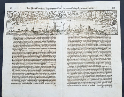
1574 Sebastian Munster Antique Map Birds Eye View of the City of Lubeck, Germany
- Title : Die Statt Lubeck
- Date : 1574
- Condition: (A+) Fine Condition
- Ref # : 22708
- Size : 15in x 13in (380mm x 340mm)
Description:
This fine original wood block engraved antique map a birds eye view of the German city of Lubeck, in the northern German state Schleswig-Holstein was published in the German Section of Sebastian Munsters 1574 edition of Cosmographia, Das ist: Beschreibung der gantzen Welt, Darinnen Aller Monarchien Keyserthumben, Königreichen, Fürstenthumben, Graff- und Herrschafften, Länderen, Stätten und Gemeinden.Ursprung (Cosmographia, that is: description of the whole world, in it all monarchies Keyser thumben, kingdoms, prince thumben, graff and herrschafften, countries, places and municipalities.)
Lübeck is a city in Schleswig-Holstein, northern Germany, and one of the major ports of Germany, on the river Trave.
In the 14th century Lübeck became the Queen of the Hanseatic League, being by far the largest and most powerful member of that medieval trade organization. In 1375 Emperor Charles IV named Lübeck one of the five Glories of the Empire, a title shared with Venice, Rome, Pisa and Florence. Several conflicts about trading privileges resulted in fighting between Lübeck (with the Hanseatic League) and Denmark and Norway – with varying outcome. While Lübeck and the Hanseatic League prevailed in conflicts in 1435 and 1512, Lübeck lost when it became involved in the Count\'s Feud, a civil war that raged in Denmark from 1534 to 1536. Lübeck also joined the pro-Lutheran Schmalkaldic League of the mid-16th century.
After its defeat in the Count\'s Feud, Lübeck\'s power slowly declined. The city remained neutral in the Thirty Years\' War of 1618–1648, but the combination of the devastation from the decades-long war and the new transatlantic orientation of European trade caused the Hanseatic League – and thus Lübeck with it – to decline in importance. However, even after the de facto disbanding of the Hanseatic League in 1669, Lübeck still remained an important trading town on the Baltic Sea.
General Definitions:
Paper thickness and quality: - Heavy and stable
Paper color : - off white
Age of map color: -
Colors used: -
General color appearance: -
Paper size: - 16in x 13in (410mm x 330mm)
Plate size: - 16in x 13in (410mm x 330mm)
Margins: - Min 1in (25mm)
Imperfections:
Margins: - None
Plate area: - Folds as issued
Verso: - None
Background:
Cosmographia, Das ist: Beschreibung der gantzen Welt, Darinnen Aller Monarchien Keyserthumben, Königreichen, Fürstenthumben, Graff- und Herrschafften, Länderen, Stätten und Gemeinden.Ursprung, Regiment, Reichthumb, Gewalt und.Beschaffenheit. Dessgleichen Aller deren, beyder Ständen, Regenten: Keysern, Königen, Bäpsten, Bischoffen.Genealogien und Stammbäumen.zusammen getragen. by Sebastian Münster was first published in 1544 and is the earliest German-language description of the world. It had numerous editions in different languages including Latin, French (translated by François de Belleforest), Italian, English, and Czech. The last German edition was published in 1628, long after Munsters death. The Cosmographia was one of the most successful and popular books of the 16th century. It passed through 24 editions in 100 years. This success was due to the notable woodcuts (some by Hans Holbein the Younger, Urs Graf, Hans Rudolph Manuel Deutsch, and David Kandel). It was most important in reviving geography in 16th-century Europe. Among the notable maps within Cosmographia is the map Tabula novarum insularum, which is credited as the first map to show the American continents as geographically discrete.
Munsters earlier geographic works were Germania descriptio (1530) and Mappa Europae (1536). In 1540, he published a Latin edition of Ptolemys Geographia with illustrations.
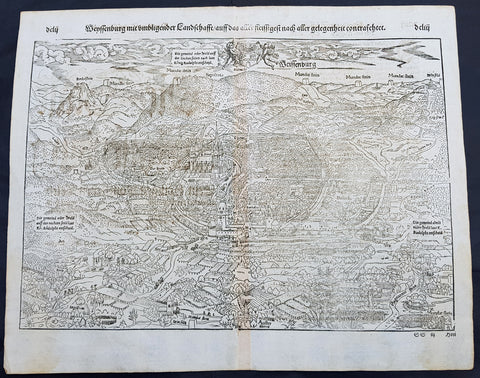
1574 Sebastian Munster Antique Map Birds Eye View of Weissenburg Bavaria Germany
- Title : Die Statt Wyssenburg
- Date : 1574
- Condition: (A+) Fine Condition
- Ref # : 22665
- Size : 15in x 13in (380mm x 340mm)
Description:
This fine original wood block engraved antique map a birds eye view of the German city of Weißenburg (Weissenburg) in Bavaria in Middle Franconia - identified by the cities Coate of Arms with double headed eagle atop of a castle - was published in the German Section of Sebastian Munsters 1574 edition of Cosmographia, Das ist: Beschreibung der gantzen Welt, Darinnen Aller Monarchien Keyserthumben, Königreichen, Fürstenthumben, Graff- und Herrschafften, Länderen, Stätten und Gemeinden.Ursprung (Cosmographia, that is: description of the whole world, in it all monarchies Keyser thumben, kingdoms, prince thumben, graff and herrschafften, countries, places and municipalities.)
Weißenburg in Bayern (formerly also Weißenburg im Nordgau) is a town in Middle Franconia, Germany. It is the capital of the district Weißenburg-Gunzenhausen. Weissenburg is located in central Bavaria, in the south of the administrative region Mittelfranken.
The history of Weißenburg is generally traced back to the Roman fort that was built in the area towards the end of the first century. The settlement, which included Thermae, lay on the border of the Roman Empire and on the Tabula Peutingeriana from the 4th century it had the name Biriciana. Germanic tribes destroyed the fort and settled in what is still the city centre. The first mention of the name Weißenburg is in a deed dating from 867. The city became the seat of a royal residence during the reign of the Franks and according to legend, Charlemagne stayed there to supervise the construction of Fossa Carolina.
The city became a Free Imperial City in 1296 and continued to grow until the Reformation. Following the example of Nuremberg the city joined the Protestant side but it suffered heavily in the ensuing wars. However, the rights of the city as a Free Imperial City and an Imperial Estate were restored in the final peace treaty and some growth resumed. Despite its insignificant size and economic importance, the city, like the other 50-odd free imperial cities, was virtually independent.
Weissenburg lost its independence in 1802 and became part of the Bavarian kingdom in 1806. It was however saved from insignificance with the construction of a railway between Nuremberg and Augsburg which goes through the city and which supported industrialisation. Following World War II over 6,000 refugees and people expelled from the territories which Germany lost settled in the city and have since played an important role in its industry and culture.
The many stages in the history of Weissenburg can still be seen today. There are many ruins from the Roman times. One of the finest is the remains of a Roman bath which was excavated in 1977 and has been turned into a museum. The city wall from the Middle Ages has survived almost intact with its towers and in the Gothic Town Hall the city\'s elected members have held their meetings from 1476.
General Definitions:
Paper thickness and quality: - Heavy and stable
Paper color : - off white
Age of map color: -
Colors used: -
General color appearance: -
Paper size: - 16in x 13in (410mm x 330mm)
Plate size: - 16in x 13in (410mm x 330mm)
Margins: - Min 1in (25mm)
Imperfections:
Margins: - None
Plate area: - None
Verso: - None
Background:
Cosmographia, Das ist: Beschreibung der gantzen Welt, Darinnen Aller Monarchien Keyserthumben, Königreichen, Fürstenthumben, Graff- und Herrschafften, Länderen, Stätten und Gemeinden.Ursprung, Regiment, Reichthumb, Gewalt und.Beschaffenheit. Dessgleichen Aller deren, beyder Ständen, Regenten: Keysern, Königen, Bäpsten, Bischoffen.Genealogien und Stammbäumen.zusammen getragen. by Sebastian Münster was first published in 1544 and is the earliest German-language description of the world. It had numerous editions in different languages including Latin, French (translated by François de Belleforest), Italian, English, and Czech. The last German edition was published in 1628, long after Munsters death. The Cosmographia was one of the most successful and popular books of the 16th century. It passed through 24 editions in 100 years. This success was due to the notable woodcuts (some by Hans Holbein the Younger, Urs Graf, Hans Rudolph Manuel Deutsch, and David Kandel). It was most important in reviving geography in 16th-century Europe. Among the notable maps within Cosmographia is the map Tabula novarum insularum, which is credited as the first map to show the American continents as geographically discrete.
Munsters earlier geographic works were Germania descriptio (1530) and Mappa Europae (1536). In 1540, he published a Latin edition of Ptolemys Geographia with illustrations.
1598 Sebastian Munster Antique Map Birds Eye View of Weissenburg Bavaria Germany
- Title : Die Statt Wyssenburg
- Date : 1598
- Condition: (A+) Fine Condition
- Ref # : 30351
- Size : 15in x 13in (380mm x 340mm)
Description:
This fine original wood block engraved antique map a birds eye view of the German city of Weißenburg (Weissenburg) in Bavaria in Middle Franconia - identified by the cities Coate of Arms with double headed eagle atop of a castle - was published in the German Section of Sebastian Munsters 1598 edition of Cosmographia, Das ist: Beschreibung der gantzen Welt, Darinnen Aller Monarchien Keyserthumben, Königreichen, Fürstenthumben, Graff- und Herrschafften, Länderen, Stätten und Gemeinden.Ursprung (Cosmographia, that is: description of the whole world, in it all monarchies Keyser thumben, kingdoms, prince thumben, graff and herrschafften, countries, places and municipalities.)
Weißenburg in Bayern (formerly also Weißenburg im Nordgau) is a town in Middle Franconia, Germany. It is the capital of the district Weißenburg-Gunzenhausen. Weissenburg is located in central Bavaria, in the south of the administrative region Mittelfranken.
The history of Weißenburg is generally traced back to the Roman fort that was built in the area towards the end of the first century. The settlement, which included Thermae, lay on the border of the Roman Empire and on the Tabula Peutingeriana from the 4th century it had the name Biriciana. Germanic tribes destroyed the fort and settled in what is still the city centre. The first mention of the name Weißenburg is in a deed dating from 867. The city became the seat of a royal residence during the reign of the Franks and according to legend, Charlemagne stayed there to supervise the construction of Fossa Carolina.
The city became a Free Imperial City in 1296 and continued to grow until the Reformation. Following the example of Nuremberg the city joined the Protestant side but it suffered heavily in the ensuing wars. However, the rights of the city as a Free Imperial City and an Imperial Estate were restored in the final peace treaty and some growth resumed. Despite its insignificant size and economic importance, the city, like the other 50-odd free imperial cities, was virtually independent.
Weissenburg lost its independence in 1802 and became part of the Bavarian kingdom in 1806. It was however saved from insignificance with the construction of a railway between Nuremberg and Augsburg which goes through the city and which supported industrialisation. Following World War II over 6,000 refugees and people expelled from the territories which Germany lost settled in the city and have since played an important role in its industry and culture.
The many stages in the history of Weissenburg can still be seen today. There are many ruins from the Roman times. One of the finest is the remains of a Roman bath which was excavated in 1977 and has been turned into a museum. The city wall from the Middle Ages has survived almost intact with its towers and in the Gothic Town Hall the city\'s elected members have held their meetings from 1476.
General Definitions:
Paper thickness and quality: - Heavy and stable
Paper color : - off white
Age of map color: -
Colors used: -
General color appearance: -
Paper size: - 16in x 13in (410mm x 330mm)
Plate size: - 16in x 13in (410mm x 330mm)
Margins: - Min 1in (25mm)
Imperfections:
Margins: - Repair to bottom margin, no loss
Plate area: - Age toning along centerfold
Verso: - Light soiling
Background:
Cosmographia, Das ist: Beschreibung der gantzen Welt, Darinnen Aller Monarchien Keyserthumben, Königreichen, Fürstenthumben, Graff- und Herrschafften, Länderen, Stätten und Gemeinden.Ursprung, Regiment, Reichthumb, Gewalt und.Beschaffenheit. Dessgleichen Aller deren, beyder Ständen, Regenten: Keysern, Königen, Bäpsten, Bischoffen.Genealogien und Stammbäumen.zusammen getragen. by Sebastian Münster was first published in 1544 and is the earliest German-language description of the world. It had numerous editions in different languages including Latin, French (translated by François de Belleforest), Italian, English, and Czech. The last German edition was published in 1628, long after Munsters death. The Cosmographia was one of the most successful and popular books of the 16th century. It passed through 24 editions in 100 years. This success was due to the notable woodcuts (some by Hans Holbein the Younger, Urs Graf, Hans Rudolph Manuel Deutsch, and David Kandel). It was most important in reviving geography in 16th-century Europe. Among the notable maps within Cosmographia is the map Tabula novarum insularum, which is credited as the first map to show the American continents as geographically discrete.
Munsters earlier geographic works were Germania descriptio (1530) and Mappa Europae (1536). In 1540, he published a Latin edition of Ptolemys Geographia with illustrations.
1824 Louis Vivien Large Antique Map of the Confederation of German States
- Title : Carte Generale de Etats compesantL Confederation Germanique...1824
- Size: 27 1/2in x 23in (700mm x 585mm)
- Condition: (A+) Fine Condition
- Date : 1824
- Ref #: 40713
Description:
This finely engraved original large antique map of the confederation of German states and central Europe, by Louis Vivien in his Elephant Folio atlas, Atlas Universal
General Definitions:
Paper thickness and quality: - Heavy and stable
Paper color : - off white
Age of map color: - Original
Colors used: - Blue, pink, yellow, green
General color appearance: - Authentic
Paper size: - 27 1/2in x 23in (700mm x 585mm)
Plate size: - 22in x 19in (560mm x 480mm)
Margins: - Min 2in (50mm)
Imperfections:
Margins: - Light soiling
Plate area: - None
Verso: - None
Background:
The German Confederation was an association of 39 German-speaking states in Central Europe (adding the mainly non-German speaking Kingdom of Bohemia and Duchy of Carniola), created by the Congress of Vienna in 1815 to coordinate the economies of separate German-speaking countries and to replace the former Holy Roman Empire, which had been dissolved in 1806. The German Confederation excluded German-speaking lands in the eastern portion of the Kingdom of Prussia (East Prussia, West Prussia and Posen), the German cantons of Switzerland, and Alsace within France which was majority German speaking.
The Confederation was weakened by rivalry between the Kingdom of Prussia and the Austrian Empire, revolution, and the inability of the multiple members to compromise. In 1848, revolutions by liberals and nationalists attempted to establish a unified German state with a progressive liberal constitution under the Frankfurt Convention. The ruling body, the Confederate Diet, was dissolved on 12 July 1848, but was re-established in 1850 after failed efforts to replace it.
The Confederation was finally dissolved after the Prussian victory in the Seven Weeks War over Austria in 1866. The dispute over which had the inherent right to rule German lands ended in favour of Prussia, leading to the creation of the North German Confederation under Prussian leadership in 1867, to which the eastern portions of the Kingdom of Prussia were added. A number of South German states remained independent until they joined the North German Confederation, which was renamed and proclaimed as the German Empire in 1871 for the now unified Germany with the Prussian king as emperor (Kaiser) after the victory over French Emperor Napoleon III in the Franco-Prussian War of 1870.
Most historians have judged the Confederation to have been weak and ineffective, as well as an obstacle to the creation of a German nation-state. However, the Confederation was designed to be weak, as it served the interests of the European Great Powers, especially member states Austria and Prussia.
Vivien, Louis 1802 - 1896
Louis Vivien , or Vivien de Saint-Martin was a French geographer who was born in Saint-Martin-de-Fontenay and died in Versailles, France in 1896.
He settled in Paris under the Restoration, and became known with his publication of the Electoral and Administrative Map in 1823 and his comprehensive Universal Atlas in 1825, collaborating with Jacques Bibliomappe -Charles Bailleul from 1828. Vivien was foremost a geographer but was also a publisher of works in other fields, including historical books on the General History of the French Revolution and the History of Napoleon. He also translated various English works, such as the novels of Walter Scott .
He also wrote the New Annals of Travels between 1845 and 1854 and briefly the French Athenaeum between 1847 & 1848. He contributed to numerous periodicals such as Le Constitutionnel, Revue contemporaine, Revue germanique & La Presse. He also wrote L Année géographique between 1863 and 1875 before passing the baton to G. Maunoir and Henri Duveyrier.
He is mainly known though, for his three cartographical works, A History of Geographical Discoveries, A New Dictionary of Universal Geography and the Universal Atlas of Geography. The first of these publications he completed after the 1848 Revolution with the latter two completed by Louis Rousselet and Franz Schrader.
Vivien was Honorary President of the Geographical Society, of which he was one of the founder members. He also laureate of the Academy of Inscriptions and Belles-Lettres as well as a member of the Asian Society , the Society of Ethnology along with a large number of learned societies and European academies.
Main works of Vivien de Saint-Martin
- General History of the French Revolution, the Empire, the Restoration, the Monarchy of 1830, up to and including 1841 (4 volumes in 2 volumes), Paris, Pourrat Brothers, 1841-1842.
- History of Napoleon and the Empire (2 volumes), Paris, Pourrat brothers, 1844.
- History of geographical discoveries of European nations in various parts of the world (2 volumes), Paris, Arthus-Bertrand, 1845-1846.
- Research on primitive populations and the oldest traditions of the Caucasus , Paris, Arthus-Bertrand, 1847.
- Studies of Ancient Geography and Asian Ethnography (2 volumes), Paris, Arthus-Bertrand, 1850-1852.
- Historical and geographical description of Asia Minor (2 volumes), Paris, Arthus-Bertrand, 1852.
- Study on the Greek and Latin Geography of India , Paris, Imperial Printing, 1858.
- Study on the geography and the primitive populations of north-west India, according to the Vedic hymns , Paris, Imprimerie impériale, 1860.
- North Africa in Greek and Roman antiquity, historical and geographical study , Paris, Imprimerie impériale, 1863.
- History of geography and geographical discoveries from the earliest times to the present day , Paris, Hachette, 1873.
- With Franz Schrader : Universal Atlas of Geography built from the original sources and the most recent documents , Paris, Hachette, 1876-1915.
- With Louis Rousselet : New dictionary of universal geography (9 volumes), Paris, Hachette, 1879-1900.
1856 Cpt R Delafield Large Antique Schematics 2nd Lancer Barracks Stables Berlin
- Title : Barrack and stables of the Lancers of the Guard at Berlin...Barrack of the Second Regiment of the Lancers of teh Guard at Berlin
- Date : 1856
- Condition: (A) Very Good Condition
- Ref: 90142
- Size: 18 1/2in x 16in (470mm x 405mm)
Description:
This large original lithograph print, schematics of the 2nd German Lancer Regiment Barracks & Stables in Berlin - during the time of the Crimean War and just prior to the American Civil War - was engraved by John T Bowen & co. of Philadelphia and was published in the 1856 edition of Captain Richard Delafields Report on the Art of War in Europe in 1854, 1855, and 1856.
In early 1855, Captain Richard Delafield was appointed by the Secretary of War, Jefferson Davis, a head of the board of officers, later called The Delafield Commission, and sent to Europe to study the European military. The board included Captain George B. McClellan and Major Alfred Mordecai. They inspected the state of the military in Great Britain, Germany, the Austrian Empire, France, Belgium, and Russia, and served as military observers during the Crimean War. After his return in April 1856, Delafield submitted a report which was later published as a book by Congress, Report on the Art of War in Europe in 1854, 1855, and 1856. The book was suppressed during the American Civil War due to fears that it would be instructive to Confederate engineers as it contained multiple drawings and descriptions of military fortifications.
General Definitions:
Paper thickness and quality: - Light and stable
Paper color : - off white
Age of map color: -
Colors used: -
General color appearance: -
Paper size: - 18 1/2in x 16in (470mm x 405mm)
Plate size: - 18 1/2in x 16in (470mm x 405mm)
Margins: - Min 1/2in (12mm)
Imperfections:
Margins: - None
Plate area: - Folds as issued
Verso: - Folds re-enforced with archival tape
Background:
A lancer was a type of cavalryman who fought with a lance. Lances were used in mounted warfare by the Assyrians as early as 700 BC and subsequently by Greek, Persian, Gallic, Chinese, and Roman horsemen. The weapon was widely used in Asia and Europe during the Middle Ages and the Renaissance by armoured cavalry, before being adopted by light cavalry, particularly in Eastern Europe. In a modern context, a lancer regiment usually denotes an armoured unit.
The lancer (called ułan in Polish and Uhlan in German) had become a common sight in almost every European, Ottoman, and Indian army during this time, but, with the exception of the Ottoman troops, they increasingly discarded the heavy armour to give greater freedom of movement in combat. The Polish winged lancers were amongst the last to abandon the armour in Europe. There was debate over the value of the lance in mounted combat during the 18th century and most armies had few lancer units by the beginning of the 19th century. However, during the Napoleonic Wars, lancers were to be seen in many of the combatant nations as their value in shock tactics became clear. During the wars, the Poles became a ready source of recruitment for several armies, willingly or unwillingly. Polish lancers served with distinction in the Austrian, Prussian, Russian and French armies, most famously in Napoleons French Imperial Guard as the 1er Regiment de Chevau-Legers-Lanciers de la Garde Impériale.
At the Battle of Waterloo, French lances were nearly three meters (about nine feet, ten inches) long, weighed three kilograms (about six pounds, ten ounces), and had a steel point on a wooden staff, according to historian Alessandro Barbero. He adds that they were terrifyingly efficient. Commander of the French 1st Corps, 4th Division General Durutte, who saw the battle from the high ground in front of Papelotte, would write later, I had never before realized the great superiority of the lance over the sword.
In the Siege of Los Angeles (1846), during the war between Mexico and the United States, a company of Californio lancers temporarily recaptured the town, expelling a company of U.S. Marines.
Although having substantial impact in the charge, lancers could be vulnerable to other cavalry at close quarters, where the lance proved a clumsy and easily deflected weapon when employed against sabres. By the late 19th century, many cavalry regiments in the British and other European armies were composed of troopers with lances, as primary weapons, in the front rank and horsemen with sabres only in the second: the lances for the initial shock and sabres for the subsequent mêlée.
Delafield, Richard Major General 1798 - 1873 - Delafield was a United States Army officer for 52 years. He served as superintendent of the United States Military Academy for 12 years. At the start of the American Civil War, then Colonel Delafield helped equip and send volunteers from New York to the Union Army. He also was in command of defences around New York harbor from 1861 to April 1864. On April 22, 1864, he was promoted to Brigadier General in the Regular Army of the United States and Chief of Engineers. On March 8, 1866, President Andrew Johnson nominated Delafield for appointment to the grade of brevet major general in the Regular Army, to rank from March 13, 1865, and the United States Senate confirmed the appointment on May 4, 1866, reconfirmed due to a technicality on July 14, 1866. He retired from the US Army on August 8, 1866. He later served on two commissions relating to improvements to Boston Harbor and to lighthouses. He also served as a regent of the Smithsonian Institution.
Delafield served as assistant engineer in the construction of Hampton Roads defences from 1819–1824 and was in charge of fortifications and surveys in the Mississippi River delta area in 1824-1832. While superintendent of repair work on the Cumberland Road east of the Ohio River, he designed and built Dunlaps Creek Bridge in Brownsville, Pennsylvania, the first cast-iron tubular-arch bridge in the United States. Commissioned a major of engineers in July 1838, he was appointed superintendent of the Military Academy after the fire of 1838 and served till 1845. He designed the new buildings and the new cadet uniform that first displayed the castle insignia. He superintended the construction of coast defences for New York Harbor from 1846 to 1855.
In the beginning of 1855, Delafield was appointed by the Secretary of War, Jefferson Davis a head of the board of officers, later called The Delafield Commission, and sent to Europe to study the European military. The board included Captain George B. McClellan and Major Alfred Mordecai. They inspected the state of the military in Great Britain, Germany, the Austrian Empire, France, Belgium, and Russia, and served as military observers during the Crimean War. After his return in April 1856, Delafield submitted a report which was later published as a book by Congress, Report on the Art of War in Europe in 1854, 1855, and 1856. The book was suppressed during the American Civil War due to fears that it would be instructive to Confederate engineers as it contained multiple drawings and descriptions of military fortifications.
Delafield served as superintendent of the Military Academy again in 1856-1861. In January 1861, he was succeeded by Captain Pierre G. T. Beauregard, who was dismissed shortly after Beauregards home state of Louisiana seceded from the Union, and Delafield returned as superintendent serving until March 1, 1861. In the beginning of the Civil War he advised the governor of New York Edwin D. Morgan during the volunteer force creation. Then, in 1861–1864, he was put in charge of New York Harbor defences, including Governors Island and Fort at Sandy Hook. On May 19, 1864, he was commissioned a brigadier-general after replacing Joseph Gilbert Totten, who had died, as the Chief of Engineers, United States Army Corps of Engineers, on April 22, 1864. He stayed in charge of the Bureau of Engineers of the War Department until his retirement on August 8, 1866. On March 8, 1866, President Andrew Johnson nominated Delafield for appointment to the grade of brevet major general in the Regular Army of the United States, to rank from March 13, 1865, and the United States Senate confirmed the appointment on May 4, 1866 and reconfirmed it due to a technicality on July 14, 1866.After retirement Delafield served as a regent of the Smithsonian Institution and a member of the Lighthouse Board. He died in Washington, D.C. on November 5, 1873.
1856 Cap Richard Delafield Large Antique Schematics German Fortifications
- Title : Theory and Practise of the German Engineers
- Date : 1856
- Condition: (A+) Fine Condition
- Ref: 90150
- Size: 24 1/2in x 18in (615mm x 475mm)
Description:
This large original lithograph print, schematics of parts of the German Forts in such cities as Coblenz, Posen, Mainz, Luxemburg, Landau & others - during the time of the Crimean War - was engraved by John T Bowen & co. of Philadelphia and was published in the 1856 edition of Captain Richard Delafields Report on the Art of War in Europe in 1854, 1855, and 1856.
In early 1855, Captain Richard Delafield was appointed by the Secretary of War, Jefferson Davis, a head of the board of officers, later called The Delafield Commission, and sent to Europe to study the European military. The board included Captain George B. McClellan and Major Alfred Mordecai. They inspected the state of the military in Great Britain, Germany, the Austrian Empire, France, Belgium, and Russia, and served as military observers during the Crimean War. After his return in April 1856, Delafield submitted a report which was later published as a book by Congress, Report on the Art of War in Europe in 1854, 1855, and 1856. The book was suppressed during the American Civil War due to fears that it would be instructive to Confederate engineers as it contained multiple drawings and descriptions of military fortifications.
General Definitions:
Paper thickness and quality: - Light and stable
Paper color : - off white
Age of map color: -
Colors used: -
General color appearance: -
Paper size: - 24 1/2in x 18in (615mm x 475mm)
Plate size: - 24 1/2in x 18in (615mm x 475mm)
Margins: - Min 1/2in (12mm)
Imperfections:
Margins: - None
Plate area: - Light age toning along folds, as issued
Verso: - Folds re-enforced with archival tape
Background:
Under the term of the 1815 Peace of Paris, France was obliged to pay for the construction of a line of fortresses to protect the German Confederation against any future aggression by France. All fortresses were located outside Austria and Prussia — the two biggest, bickering powers of the Confederation.
Section C. Defensive System of the Germanic Confederation of the protocol drawn up at Paris on 3 November 1815, declared Mainz, Luxemburg, and Landau to be fortresses belonging to the Confederation of Germany, and stipulated that a fourth should be constructed on the Upper Rhine. In conformity with this act, a portion of the funds, which France was compelled to pay by way of indemnity for the cost of placing her on a peaceable footing, was thus appropriated: £200,000 were set aside for completing the works at Mainz; £800,000 were assigned to Prussia, to be applied upon its fortresses on the Lower Rhine; another £800,000 were reserved for constructing the new federal fortress on the Upper Rhine; and Bavaria was allowed £600,000 towards erecting another strong place on the Rhine, at Germersheim or some other point.
By 1835 the works about Mainz were completed; the twin fortresses of Koblenz and Ehrenbreitstein, and Cologne had been abundantly strengthened on the side of Prussia; and, on the Bavarian side, the fortress of Germersheim was in a state to defend the passage on the Upper Rhine. The western frontier of Germany had, in this way, been provided with a formidable line of defences against possible hostile actions by their neighbours. The eastern side of Germany has been additionally fortified by the erection of a strong citadel at Posen; and the southern was to be still further protected by the formidable works in course of construction at Brixen in the Tyrol.
The fortress of Ulm became a major strategic fortress able to accommodate 100,000 men and their equipment. Since the Kingdom of Württemberg had no engineering corps King William I appointed Moritz Karl Ernst von Prittwitz, a Prussian major, as the supervisor to oversee the building the fortresses. His plans included the provisions for the prospective development of the city Ulm. Major Theodor von Hildebrandt was appointed to oversee the building of fortresses around Neu-Ulm on the Bavarian side of the Danube
Delafield, Richard Major General 1798 - 1873 - Delafield was a United States Army officer for 52 years. He served as superintendent of the United States Military Academy for 12 years. At the start of the American Civil War, then Colonel Delafield helped equip and send volunteers from New York to the Union Army. He also was in command of defences around New York harbor from 1861 to April 1864. On April 22, 1864, he was promoted to Brigadier General in the Regular Army of the United States and Chief of Engineers. On March 8, 1866, President Andrew Johnson nominated Delafield for appointment to the grade of brevet major general in the Regular Army, to rank from March 13, 1865, and the United States Senate confirmed the appointment on May 4, 1866, reconfirmed due to a technicality on July 14, 1866. He retired from the US Army on August 8, 1866. He later served on two commissions relating to improvements to Boston Harbor and to lighthouses. He also served as a regent of the Smithsonian Institution.
Delafield served as assistant engineer in the construction of Hampton Roads defences from 1819–1824 and was in charge of fortifications and surveys in the Mississippi River delta area in 1824-1832. While superintendent of repair work on the Cumberland Road east of the Ohio River, he designed and built Dunlaps Creek Bridge in Brownsville, Pennsylvania, the first cast-iron tubular-arch bridge in the United States. Commissioned a major of engineers in July 1838, he was appointed superintendent of the Military Academy after the fire of 1838 and served till 1845. He designed the new buildings and the new cadet uniform that first displayed the castle insignia. He superintended the construction of coast defences for New York Harbor from 1846 to 1855.
In the beginning of 1855, Delafield was appointed by the Secretary of War, Jefferson Davis a head of the board of officers, later called The Delafield Commission, and sent to Europe to study the European military. The board included Captain George B. McClellan and Major Alfred Mordecai. They inspected the state of the military in Great Britain, Germany, the Austrian Empire, France, Belgium, and Russia, and served as military observers during the Crimean War. After his return in April 1856, Delafield submitted a report which was later published as a book by Congress, Report on the Art of War in Europe in 1854, 1855, and 1856. The book was suppressed during the American Civil War due to fears that it would be instructive to Confederate engineers as it contained multiple drawings and descriptions of military fortifications.
Delafield served as superintendent of the Military Academy again in 1856-1861. In January 1861, he was succeeded by Captain Pierre G. T. Beauregard, who was dismissed shortly after Beauregards home state of Louisiana seceded from the Union, and Delafield returned as superintendent serving until March 1, 1861. In the beginning of the Civil War he advised the governor of New York Edwin D. Morgan during the volunteer force creation. Then, in 1861–1864, he was put in charge of New York Harbor defences, including Governors Island and Fort at Sandy Hook. On May 19, 1864, he was commissioned a brigadier-general after replacing Joseph Gilbert Totten, who had died, as the Chief of Engineers, United States Army Corps of Engineers, on April 22, 1864. He stayed in charge of the Bureau of Engineers of the War Department until his retirement on August 8, 1866. On March 8, 1866, President Andrew Johnson nominated Delafield for appointment to the grade of brevet major general in the Regular Army of the United States, to rank from March 13, 1865, and the United States Senate confirmed the appointment on May 4, 1866 and reconfirmed it due to a technicality on July 14, 1866.After retirement Delafield served as a regent of the Smithsonian Institution and a member of the Lighthouse Board. He died in Washington, D.C. on November 5, 1873.