Products
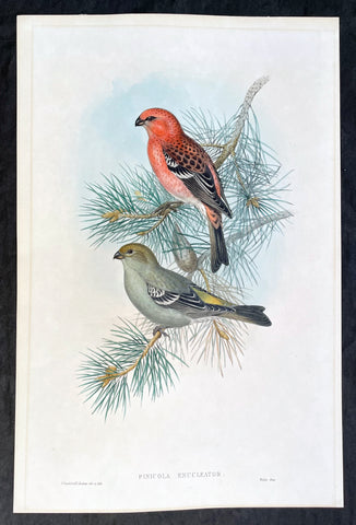
1862 John Gould Large Antique Print Birds of Great Britain - Pine Grosbeak
- Title : Pinicola Enucleator
- Ref #: 23486
- Size: 21 1/2in x 14in (545mm x 360mm)
- Date : 1862
- Condition: (A+) Fine Condition
Description:
This large original hand coloured antique lithograph of the male & female Pine Grosbeak or Pinicola Enucleator, found from Siberia to the United States, was published in the 1862-73 edition of John Goulds The Birds of Great Britain. Lithography by J Gould, HC Richter & Walter.
The University of Glasgow, which owns a copy of Birds of Great Britain, describes John Gould as the greatest figure in bird illustration after Audubon. Gould was not directly responsible for the illustrations himself, although he supervised their production closely. Auctioneers Sotherans describe the work as Goulds pride and joy.
Gould had already published some of the illustrations in Birds of Europe, but Birds of Great Britain represents a development of an aesthetic style in which illustrations of nests and young are added on a large scale.
Sotherans Co. reports that Gould published the book himself, producing 750 copies, which remain sought after both as complete volumes, and as individual plates, currently varying in price from £450 – £850. The University of Glasgow records that the volumes were issued in London in 25 parts, to make the complete set, between 1863 and 1873, and each set contained 367 coloured lithographs.
Gould undertook an ornithological tour of Scandinavia in 1856, in preparation for the work, taking with him the artist Henry Wolf who drew 57 of the plates from Goulds preparatory sketches. According to The University of Glasgow Goulds skill was in rapidly producing rough sketches from nature (a majority of the sketches were drawn from newly killed specimens) capturing the distinctiveness of each species. Gould then oversaw the process whereby his artists worked his sketches up into the finished drawings, which were made into coloured lithographs by engraver William Hart.
There were problems: the stone engraving of the snowy owl in volume I was dropped and broken at an early stage in the printing. Later issues of this plate show evidence of this damage and consequently the early issue – printed before the accident – are considered more desirable.
The lithographs were hand coloured. In the introduction for the work, Gould states every sky with its varied tints and every feather of each bird were coloured by hand; and when it is considered that nearly two hundred and eighty thousand illustrations in the present work have been so treated, it will most likely cause some astonishment to those who give the subject a thought.
The work has gathered critical acclaim: according to Mullens and Swann, Birds of Great Britain is the most sumptuous and costly of British bird books, whilst Wood describes it as a magnificent work. Isabella Tree writes that it was seen – perhaps partly because its subject was British, as the culmination of [his] ... genius.
General Definitions:
Paper thickness and quality: - Heavy and stable
Paper color : - off white
Age of map color: - Original
Colors used: - Yellow, green, blue, pink
General color appearance: - Authentic
Paper size: - 21 1/2in x 14in (545mm x 360mm)
Plate size: - 21 1/2in x 14in (545mm x 360mm)
Margins: - Min 1/2in (12mm)
Imperfections:
Margins: - Light matt line to border
Plate area: - None
Verso: - None
Background:
One of the great bird artists of all time, John Gould created over 3,000 plates of birds in over 40 volumes.
Around 1830, while working as taxidermist for the Zoological Society of London, he received a shipment of exotic bird skins from the Himalayas. Soon after, he published A Century of Birds from the Himalaya Mountains.
The success of this work, along with the Birds of Europe (1832-37) and a Monograph of the Ramphastidae [Toucans] allowed him to travel to Australia and New Guinea. Among Gould's better known works are the Birds of Australia (1849-69), the Birds of Asia (1850-83), and Birds of Great Britain (1862-73).
Though Gould himself sketched most of his plates, other artists such as his wife Elizabeth, Edward Lear, Joseph Wolf, William Hart and Henry C. Richter finished them. Gould's plates are highly esteemed for their composition, accurate detail, and coloring. (Ref: Methuen)
Please note all items auctioned are genuine, we do not sell reproductions. A Certificate of Authenticity (COA) can be issued on request.
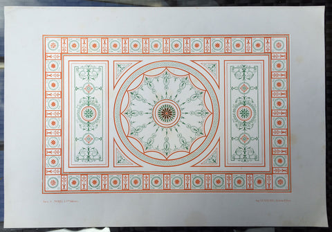
1862 Morel & Lemercier Large Antique French Lithograph Decoration Print
- Title : Paris A Morel & Co. Editeurs...Imp. Lemercier r de Seine 57 Paris
- Date : 1862
- Condition: (A+) Fine Condition
- Ref: 70540
- Size: 16 1/2in x 13 1/2in (460mm x 345mm)
Description:
This fine large original antique chromolithograph print of interior French decoration from the mid 19th century was published in the 1862 edition of Manuel de Peintures by A Morel & Co. Editeurs , Paris with the Chromolithograph by the famous French firm of Lemercier, Paris
General Description:
Paper thickness and quality: - Heavy & stable
Paper color: - White
Age of map color: - Original
Colors used: - Red, Green
General color appearance: - Authentic
Paper size: - 16 1/2in x 13 1/2in (460mm x 345mm)
Margins: - Min 1in (25mm)
Imperfections:
Margins: - None
Plate area: - None
Verso: - None
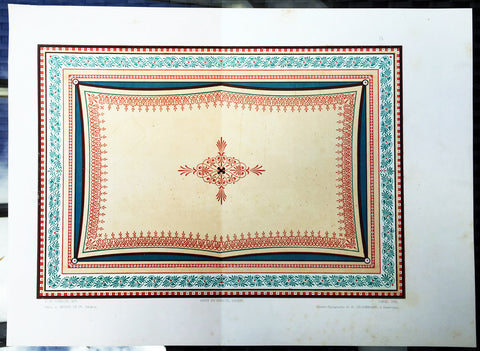
1862 Morel & Lemercier Large Antique French Lithograph Decoration Print
- Title : Paris A Morel & Co. Editeurs...Imp. Petit et Bisiaux Lemercier r de Seine 57 Paris
- Date : 1862
- Condition: (A+) Fine Condition
- Ref: 70549
- Size: 16 1/2in x 13 1/2in (460mm x 345mm)
Description:
This fine large original antique chromolithograph print of interior French decoration from the mid 19th century was published in the 1862 edition of Manuel de Peintures by A Morel & Co. Editeurs , Paris with the Chromolithograph by the famous French firm of Lemercier, Paris
General Description:
Paper thickness and quality: - Heavy & stable
Paper color: - White
Age of map color: - Original
Colors used: - Red, Green
General color appearance: - Authentic
Paper size: - 16 1/2in x 13 1/2in (460mm x 345mm)
Margins: - Min 1in (25mm)
Imperfections:
Margins: - Light spotting in bottom margin
Plate area: - None
Verso: - None
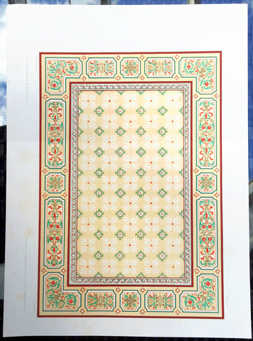
1862 Morel & Lemercier Large Antique French Lithograph Decoration Print
- Title : Paris A Morel & Co. Editeurs...Imp. Lemercier r de Seine 57 Paris
- Date : 1862
- Condition: (A+) Fine Condition
- Ref: 70548
- Size: 16 1/2in x 13 1/2in (460mm x 345mm)
Description:
This fine large original antique chromolithograph print of interior French decoration from the mid 19th century was published in the 1862 edition of Manuel de Peintures by A Morel & Co. Editeurs , Paris with the Chromolithograph by the famous French firm of Lemercier, Paris
General Description:
Paper thickness and quality: - Heavy & stable
Paper color: - White
Age of map color: - Original
Colors used: - Red, Green
General color appearance: - Authentic
Paper size: - 16 1/2in x 13 1/2in (460mm x 345mm)
Margins: - Min 1in (25mm)
Imperfections:
Margins: - None
Plate area: - None
Verso: - None

1862 US Coast Survey & A D Bache Large Rare Antique Map of Puget & Washington Sound, Washington
- Title : US Coast Survey A D Bache Super. Reconnaissance of Washington Sound and approaches Washington Territory...1862.
- Size: 28 1/2in x 26 1/2in (730mm x 690mm)
- Condition: (A+) Fine Condition
- Date : 1862
- Ref #: 93034-1
Description:
This large, rare, original antique lithograph early map of Puget & Washington Sound, Washington State, by Alexander Dallas Bache (great-grandson of Benjamin Franklin) in 1862 - dated - was published by the official chart-maker of the United States, the office of The US Coast Survey.
The Office of the Coast Survey, founded in 1807 by President Thomas Jefferson and Secretary of Commerce Albert Gallatin, is the oldest scientific organization in the U.S. Federal Government. Jefferson created the Survey of the Coast, as it was then called, in response to a need for accurate navigational charts of the new nation\'s coasts and harbors.
General Definitions:
Paper thickness and quality: - Heavy and stable
Paper color : - off white
Age of map color: -
Colors used: -
General color appearance: -
Paper size: - 28 1/2in x 26 1/2in (730mm x 690mm)
Plate size: - 28 1/2in x 26 1/2in (730mm x 690mm)
Margins: - Min 1/2in (12mm)
Imperfections:
Margins: - None
Plate area: - Folds as issued
Verso: - None
Background:
George Vancouver explored Puget Sound in 1792. Vancouver claimed it for Great Britain on 4 June 1792, naming it for one of his officers, Lieutenant Peter Puget.
After 1818 Britain and the United States, which both claimed the Oregon Country, agreed to joint occupancy, deferring resolution of the Oregon boundary dispute until the 1846 Oregon Treaty. Puget Sound was part of the disputed region until 1846, after which it became US territory.
American maritime fur traders visited Puget Sound in the early 19th century.
The first European settlement in the Puget Sound area was Fort Nisqually, a fur trade post of the Hudsons Bay Company (HBC) built in 1833. Fort Nisqually was part of the HBCs Columbia District, headquartered at Fort Vancouver. The Puget Sound Agricultural Company, a subsidiary of the HBC, established farms and ranches near Fort Nisqually. British ships such as the Beaver, exported foodstuffs and provisions from Fort Nisqually.
The first American settlement on Puget Sound was Tumwater. It was founded in 1845 by Americans who had come via the Oregon Trail. The decision to settle north of the Columbia River was made in part because one of the settlers, George Washington Bush, was considered black and the Provisional Government of Oregon banned the residency of mulattoes but did not actively enforce the restriction north of the river.
In 1853 Washington Territory was formed from part of Oregon Territory. In 1888 the Northern Pacific railroad line reached Puget Sound, linking the region to eastern states.
U.S. Coast Survey (Office of Coast Survey)
The Office of Coast Survey is the official chart-maker of the United States. Set up in 1807, it is one of the U.S. governments oldest scientific organizations. In 1878 it was given the name of Coast and Geodetic Survey (C&GS). In 1970 it became part of the National Oceanic and Atmospheric Administration (NOAA).
The agency was established in 1807 when President Thomas Jefferson signed the document entitled An act to provide for surveying the coasts of the United States. While the bills objective was specific—to produce nautical charts—it reflected larger issues of concern to the new nation: national boundaries, commerce, and defence.
The early years were difficult. Ferdinand Rudolph Hassler, who was eventually to become the agencys first superintendent, went to England to collect scientific instruments but was unable to return through the duration of the War of 1812. After his return, he worked on a survey of the New York Harbor in 1817, but Congress stepped in to suspend the work because of tensions between civilian and military control of the agency. After several years under the control of the U.S. Army, the Survey of the Coast was reestablished in 1832, and President Andrew Jackson appointed Hassler as superintendent.
The U.S. Coast Survey was a civilian agency but, from the beginning, members of the Navy and Army were detailed to service with the Survey, and Navy ships were also detailed to its use. In general, army officers worked on topographic surveys on the land and maps based on the surveys, while navy officers worked on hydrographic surveys in coastal waters.
Alexander Dallas Bache, great-grandson of Benjamin Franklin, was the second Coast Survey superintendent. Bache was a physicist, scientist, and surveyor who established the first magnetic observatory and served as the first president of the National Academy of Sciences. Under Bache, Coast Survey quickly applied its resources to the Union cause during the Civil War. In addition to setting up additional lithographic presses to produce the thousands of charts required by the Navy and other vessels, Bache made a critical decision to send Coast Survey parties to work with blockading squadrons and armies in the field, producing hundreds of maps and charts. Bache detailed these activities in his annual reports to Congress.
Coast Survey cartographer Edwin Hergesheimer created the map showing the density of the slave population in the Southern states.
Bache was also one of four members of the governments Blockade Strategy Board, planning strategy to essentially strangle the South, economically and militarily. On April 16, 1861, President Lincoln issued a proclamation declaring the blockade of ports from South Carolina to Texas. Baches Notes on the Coast provided valuable information for Union naval forces.
Maps were of paramount importance in wartime:
It is certain that accurate maps must form the basis of well-conducted military operations, and that the best time to procure them is not when an attack is impending, or when the army waits, but when there is no hindrance to, or pressure upon, the surveyors. That no coast can be effectively attacked, defended, or blockaded without accurate maps and charts, has been fully proved by the events of the last two years, if, indeed, such a proposition required practical proof.
— Alexander Dallas Bache, 1862 report.
Coast Survey attracted some of the best and brightest scientists and naturalists. It commissioned the naturalist Louis Agassiz to conduct the first scientific study of the Florida reef system. James McNeill Whistler, who went on to paint the iconic Whistlers Mother, was a Coast Survey engraver. The naturalist John Muir was a guide and artist on Survey of the 39th Parallel across the Great Basin of Nevada and Utah.
The agencys men and women (women professionals were hired as early as 1845) led scientific and engineering activities through the decades. In 1926, they started production of aeronautical charts. During the height of the Great Depression, Coast and Geodetic Survey organized surveying parties and field offices that employed over 10,000 people, including many out-of-work engineers.
In World War II, C&GS sent over 1,000 civilian members and more than half of its commissioned officers to serve as hydrographers, artillery surveyors, cartographers, army engineers, intelligence officers, and geophysicists in all theaters of the war. Civilians on the home front produced over 100 million maps and charts for the Allied Forces. Eleven members of the C&GS gave their lives during the war.
Alexander Dallas Bache 1806 – 1867 was an American physicist, scientist, and surveyor who erected coastal fortifications and conducted a detailed survey to map the mid-eastern United States coastline. Originally an army engineer, he later became Superintendent of the U.S. Coast Survey, and built it into the foremost scientific institution in the country before the Civil War.
Alexander Bache was born in Philadelphia, the son of Richard Bache, Jr., and Sophia Burrell Dallas Bache. He came from a prominent family as he was the nephew of Vice-President George M. Dallas and naval hero Alexander J. Dallas. He was the grandson of Secretary of the Treasury Alexander Dallas and was the great-grandson of Benjamin Franklin.
Bache was a professor of natural philosophy and chemistry at the University of Pennsylvania from 1828 to 1841 and again from 1842 to 1843. He spent 1836–1838 in Europe on behalf of the trustees of what became Girard College; he was named president of the college after his return. Abroad, he examined European education systems, and on his return he published a valuable report. From 1839 to 1842, he served as the first president of Central High School of Philadelphia, one of the oldest public high schools in the United States.
In 1843, on the death of Professor Ferdinand Rudolph Hassler, Bache was appointed superintendent of the United States Coast Survey. He convinced the United States Congress of the value of this work and, by means of the liberal aid it granted, he completed the mapping of the whole coast by a skillful division of labor and the erection of numerous observing stations. In addition, magnetic and meteorological data were collected. Bache served as head of the Coast Survey for 24 years (until his death).
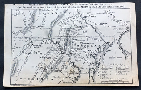
1863 Dangerfield Rare Antique Map of Gettysburg, American Civil War, 1 July 1863
- Title : Sketch to show the advance of Ewell into Pennsylvania (marked thus_._._._.) also the simultaneous concentration of the armies of Lee and MEADE on Gettysburg on the 1st of July 1863...F Dangerfield Lith. 22 Bedford St Covent Garden
- Date : 1863
- Size: 8 1/2in x 5 1/2in (215mm x 140mm)
- Ref #: 61002
- Condition: (A+) Fine Condition
Description:
This rare original antique military map of the intersection of Pennsylvania, Maryland & Virginia centering on Chambersburg & Gettysburg on the 1st of July 1863 was published by Frederick Dangerfield in late 1863.
The map illustrating possibly the most famous battle of the American Civil War also contains a legend showing the position of both the Federal & Confederate Armies on that day.
The Battle of Gettysburg was fought July 1–3, 1863, in and around the town of Gettysburg, Pennsylvania, by Union and Confederate forces during the American Civil War. The battle involved the largest number of casualties of the entire war and is often described as the war's turning point. Union Maj. Gen. George Meade's Army of the Potomac defeated attacks by Confederate Gen. Robert E. Lee's Army of Northern Virginia, ending Lee's attempt to invade the North.
After his success at Chancellorsville in Virginia in May 1863, Lee led his army through the Shenandoah Valley to begin his second invasion of the North—the Gettysburg Campaign. With his army in high spirits, Lee intended to shift the focus of the summer campaign from war-ravaged northern Virginia and hoped to influence Northern politicians to give up their prosecution of the war by penetrating as far as Harrisburg, Pennsylvania, or even Philadelphia. Prodded by President Abraham Lincoln, Maj. Gen. Joseph Hooker moved his army in pursuit, but was relieved of command just three days before the battle and replaced by Meade.
Elements of the two armies initially collided at Gettysburg on July 1, 1863, as Lee urgently concentrated his forces there, his objective being to engage the Union army and destroy it. Low ridges to the northwest of town were defended initially by a Union cavalry division under Brig. Gen. John Buford, and soon reinforced with two corps of Union infantry. However, two large Confederate corps assaulted them from the northwest and north, collapsing the hastily developed Union lines, sending the defenders retreating through the streets of the town to the hills just to the south.
On the second day of battle, most of both armies had assembled. The Union line was laid out in a defensive formation resembling a fishhook. In the late afternoon of July 2, Lee launched a heavy assault on the Union left flank, and fierce fighting raged at Little Round Top, the Wheatfield, Devil's Den, and the Peach Orchard. On the Union right, Confederate demonstrations escalated into full-scale assaults on Culp's Hill and Cemetery Hill. All across the battlefield, despite significant losses, the Union defenders held their lines.
On the third day of battle, fighting resumed on Culp's Hill, and cavalry battles raged to the east and south, but the main event was a dramatic infantry assault by 12,500 Confederates against the center of the Union line on Cemetery Ridge, known as Pickett's Charge. The charge was repulsed by Union rifle and artillery fire, at great loss to the Confederate army.
Lee led his army on a torturous retreat back to Virginia. Between 46,000 and 51,000 soldiers from both armies were casualties in the three-day battle, the most costly in US history.
On November 19, President Lincoln used the dedication ceremony for the Gettysburg National Cemetery to honor the fallen Union soldiers and redefine the purpose of the war in his historic Gettysburg Address. (Ref Tooley M&B)
General Description:
Paper thickness and quality: - Heavy and stable
Paper color: - off white
Age of map color: -
Colors used: -
General color appearance: -
Paper size: - 8 1/2in x 5 1/2in (215mm x 140mm)
Plate size: - 8 1/2in x 5 1/2in (215mm x 140mm)
Margins: - Min 1/4in (5mm)
Imperfections:
Margins: - Light age top margin cropped closed to title
Plate area: - None
Verso: - None
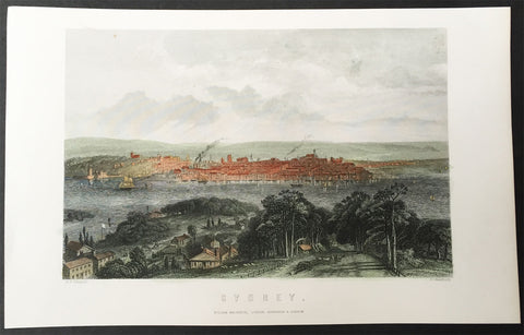
1865 George Frederick Sargent Antique Print View of Sydney across the Harbour
- Title : Sydney....G F Sargent....G Greatbach....William Mackenzie; London, Edinburgh & Glasgow
- Ref #: 35518
- Size: 10in x 6 1/2in (255mm x 165mm)
- Date : 1864
- Condition: (A+) Fine Condition
Description:
This hand coloured original steel-plate engraved antique print of Sydney NSW, north across the Rocks with a view to St James Church on Kings St, across the harbour where the Harbour Bridge now sits, after the Australian artist George Frederick Sargent in 1859 was engraved by G. Greatbach and published by William Mackenzie and co. in 1865.
General Definitions:
Paper thickness and quality: - Heavy and stable
Paper color : - off white
Age of map color: - Early
Colors used: - Yellow, green, blue, pink
General color appearance: - Authentic
Paper size: - 25in x 21 1/4in (635mm x 540mm)
Plate size: - 23in x 19 1/2in (590mm x 500mm)
Margins: - Min 1/2in (12mm)
Imperfections:
Margins: - Small repair to top margin, no loss
Plate area: - None
Verso: - None
Background:
The History of Sydney begins in prehistoric times with the occupation of the district by Australian Aborigines, whose ancestors came to Sydney in the Upper Paleolithic period. The modern history of the city began with the arrival of a First Fleet of British ships in 1788 and the foundation of a penal colony by Great Britain.
From 1788 to 1900 Sydney was the capital of the British colony of New South Wales. An elected city council was established in 1840. In 1900, Sydney became a state capital, when New South Wales voted to join the Australian Federation. Sydney today is Australias largest city and a major international capital of culture and finance.
Mackenzie, William active 1860-70
William Mackenzie, Ludgate Hill, London, Edinburgh and Glasgow, was a well-known publisher of natural history books in the 1860s & 70s. He published works by the trio of Francis Orpen Morris, Benjamin Fawcett and Alexander Francis Lydon. His best-known publication was probably County Seats of The Noblemen and Gentlemen of Great Britain and Ireland in 1870
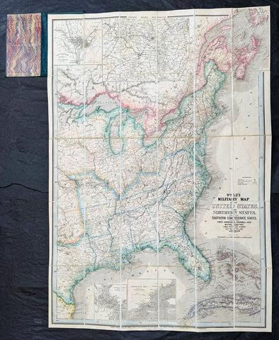
1865 James Wyld Large Antique Folding American Civil War Map - Extremely Rare
- Title : Wyld's Military Map Of The United States, The Northern States, And The Southern Confederate States: With The Forts, Harbours, Arsenals And Military Positions. James Wyld, 457 Strand; Charing Cross East And 2, Royal Exchange London. ......London, Published By James Wyld, Geographer To The Queen
- Date : 1865
- Size: 34 1/2in x 24in (875mm x 610mm)
- Condition: (A+) Fine Condition
- Ref: 35660
Description:
A very rare map of the United States first issued in 1861, during the Secession Crises that preceded the outbreak of the American Civil War, with this rare edition issued in January 1865 - dated at the foot of the map, only 4 months before the end of the war..
There are a few 1861 editions of this map for sale, currently on the market, but I have been unable to find an 1865 edition, either currently on the market or sold in the past.
General Definitions:
Paper thickness and quality: - Heavy and stable
Paper color : - off white
Age of map color: - Original
Colors used: - Yellow, green, blue, pink
General color appearance: - Authentic
Paper size: - 34 1/2in x 24in (875mm x 610mm)
Plate size: - 34 1/2in x 24in (875mm x 610mm)
Margins: - Min 1/2in (12mm)
Imperfections:
Margins: - None
Plate area: - None
Verso: - None
Background:
Wyld was particularly masterful at capturing political events throughout the world as they happened and leveraging his impressive publishing operation to quickly produce and distribute pertinent to the invested public. In this case, the map distinguishes between the 'Northern States' (orange border) and the 'Southern Confederate States' (blue border). Wyld here erroneously conflates slaveholding states with Confederate secessionist states - in particular, Missouri, Kentucky, Delaware, and Maryland, which allowed slavery but remained loyal to the Union. Arsenals, forts, and military posts highlighted and keyed, underscoring that 'war' was very much in the air. The map is also noteworthy for recognizes the apocryphal territory 'Chippewa', roughly corresponding to modern-day North Dakota.
This map is scarce to the market. Known institutions holdings at the Boston Public Library, the Library of Congress, Bibliothèque nationale de France, the David Rumsey Collection, among others. (Ref: M&B; Tooley; Clancy) (Ref: Tooley, Koeman, Burden)
Please note all items auctioned are genuine, we do not sell reproductions. A Certificate of Authenticity (COA) can be issued on request.
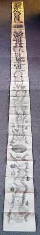
1866 A.R. Waud Long Folding Antique Map St Lawrence River Niagara Fall to Quebec
- Title : ...(Panoramic view of the St Lawrence River from Niagara Falls to Quebec City)....Drawn by Alfred R Waud Boston US
- Size: 144in x 7 1/2in (365cm x 190mm)
- Condition: (A+) Fine Condition
- Date : 1866
- Ref #: 91279
Description:
This is an extraordinary piece of antique early marketing promotion drawn by one of Americas famous Civil War illustrators Alfred Waud.
This very long (12ft) folding lithograph map, a panoramic birds eye view of the St Lawrence River from Niagara Falls to the city of Quebec was drawn by Alfred Waud and published in c1866.
General Definitions:
Paper thickness and quality: - Heavy and stable
Paper color : - off white
Age of map color: -
Colors used: -
General color appearance: -
Paper size: - 144in x 7 1/2in (365cm x 190mm)
Plate size: - 144in x 7 1/2in (365cm x 190mm)
Margins: - N/A
Imperfections:
Margins: - Light age toning
Plate area: - Folds as issued, light age toning
Verso: - Light age toning
Background:
This is a rare piece and lucky to have survived intact and in such good condition. The map begins at Niagara falls to lake Ontario noting all towns and settlements, including Native Americans, carrying on Prescott, many other smaller towns. Illustrations of Native Americans, trappers, ships, wrecks and much more ending up in the city of Quebec adorn the map
Waud, Alfred 1828 - 1891
Waud was an American artist and illustrator, born in London, England. He is most notable for the sketches he made as an artist correspondent during the American Civil War.
The period during the American Civil War was a time when all images in a publication had to be hand drawn and engraved by skilled artists. Photography existed but there was no way to transfer a photograph to a printing plate since this was well before the advent of the halftone process for printing photographs. Photographic equipment was too cumbersome and exposure times were too slow to be used on the battlefield. An artist such as Waud would do detailed sketches in the field, which were then rushed by courier back to the main office of the newspaper they were working for. There a staff of engravers would use the sketches to create engravings on blocks of boxwood. Since the blocks were about 4 inches across they would have to be composited together to make one large illustration. The wood engraving was then copied via the electrotype process which produced a metal printing plate for publication.
In 1860, Alfred Waud became an illustrator or special artist (a full-time paid staff artist) for the New York Illustrated News. In April 1861, the newspaper assigned Waud to cover the Army of the Potomac, Virginias main Union army. He first illustrated General Winfield Scott in Washington, D.C., and then entered the field to render the First Battle of Bull Run in July. Waud followed a Union expedition to Cape Hatteras, North Carolina the next month and witnessed the Battle of Hatteras Inlet Batteries. That autumn, he sketched army activity in the Tidewater region of Virginia. Waud joined Harpers Weekly toward the end of 1861, continuing to cover the war. In 1864 Alfreds brother, William Waud (who up to that time had been working with Frank Leslies Illustrated Newspaper), joined Alfred on the staff of Harpers and they worked together during the Petersburg Campaign.
Alfred Waud attended every battle of the Army of the Potomac between the First Battle of Bull Run in 1861 and the Siege of Petersburg in 1865. Alfred was one of only two artists present at the Battle of Gettysburg. His depiction of Picketts Charge is thought to be the only visual account by an eyewitness.
Waud continued to be a prolific illustrator, doing numerous illustrations for Harpers Weekly and other prominent publications, achieving his greatest fame in his post-War work.
Waud died in 1891 in Marietta, Georgia, while touring battlefields of the South.
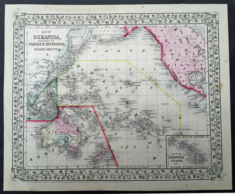
1867 Mitchell Antique Map of The Pacific, Australia, America, China & Hawaii
- Title : Map of Oceania exhibiting its various divisions Island group....1867 by S. Augustus Mitchell
- Date : 1867
- Condition: (A+) Fine Condition
- Ref: 35055
- Size: 15in x 12in (380mm x 300mm)
Description:
This beautifully hand coloured original antique map was published by Samuel Augustus Mitchell in the 1867 edition of his large New General Atlas - dated at the foot of the map. These county, state, city & country maps are some of the most ornate and beautifully coloured maps published in the US in the 19th century. For over 50 years, Mitchell his son's and their successors were the most prominent cartographical publishers of maps and atlases in the United States.
General Description:
Paper thickness and quality: - Heavy & stable
Paper color: - White
Age of map color: - Original
Colors used: - Green, pink, yellow
General color appearance: - Authentic
Paper size: - 15in x 12in (380mm x 300mm)
Plate size: - 15in x 12in (380mm x 300mm)
Margins: - Min 1/2in (10mm)
Imperfections:
Margins: - None
Plate area: - None
Verso: - None
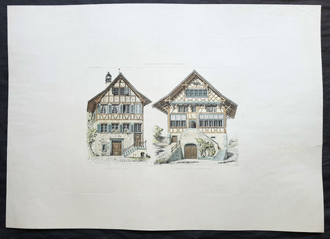
1868 Ernst Gladbach Large Original Antique Print of Houses in Zurich Switzerland
- Title : Meierhof in Hoengg; Schirmensee bei Rapperschwyl
- Ref : 70526
- Size: 27in x 19in (685mm x 485mm)
- Date : 1868
- Condition: (A) Very Good Condition
Description:
This large original copper plate engraved antique print, details of houses of the Hongg & Rapperswil districts in the Swiss city of Zurich by Ernst Gladbach, was published in the 1868 edition of Der Schweizer Holzstyl in seinen cantonalen und constructiven Verschiedenheiten vergleichend dargestellt mit Holzbauten Deutschlands . Darmstadt: Carl Koehler\'s Verlag.
(Translation of title: The comparisons in construction & details between wooden houses in Switzerland and Germany)
General Definitions:
Paper thickness and quality: - Heavy and stable
Paper color : - off white
Age of map color: - Original
Colors used: - Yellow, blue, green, brown
General color appearance: - Authentic
Paper size: - 27in x 19in (685mm x 485mm)
Plate size: - 18 1/2in x 13 1/2in (470mm x 345mm)
Margins: - Min 2in (50mm)
Imperfections:
Margins: - Small repair to left margin, no loss
Plate area: - Central vertical fold
Verso: - None
Gladbach, Ernst Georg 1812 - 1896
Born in Darmstadt, Germany the son of a jurist, Gladbach early on became involved in architecture and construction issues in particular through his uncle Georg Moller Moller [1784-1852] was an influential court builder in the Grand Duchy of Hesse. At the age of 14 Gladbach began an apprenticeship in his uncle’s office. He soon worked on major projects such as the theatre of Mainz [1829-1833] and supported his uncle in teaching young architects. Aside from this, he became involved with the book series Denkmaler der deutschen Baukunst (Moller 1815-1851). In the large-format illustrated volumes Moller presented detailed architectural surveys of medieval buildings. In the books and in his work as an architect and teacher he focused on construction issues in particular. Between 1833-1844 he published his own textbook on construction, under the title Beiträge zu der Lehre von den Construktionen, that assembled surveys of exemplary buildings. For Gladbach’s further work, the exposure to construction issues in his uncle’s office was formative. In addition, Gladbach received drawing lessons from his cousin Fritz Hessemer who also worked in Moller’s office. The lessons resulted in the publication of some of Gladbach’s artistic drawings by a publisher in Darmstadt. After studying at the universities in Giessen and Heidelberg, Gladbach further improved his drawing skills on a three-year study trip that took him to different German cities and then to Italy from 1837 to 1839. Back in Germany Gladbach worked as a master builder for the Hesse state civil service, dealing with timber construction mainly in a practical way. In his spare time he did some building surveys that he published together with some of Moller’s surveys as a third volume to the series Denkmäler der deutschen Baukunst. In 1857 Gladbach was appointed professor for structural theory and construction materials at the newly founded Swiss Polytechnic School in Zurich and kept this position until 1890. Being professor at the Polytechnic School, he shifted once more the main focus of his work: Gladbach stopped being professionally active as an architect. Instead, teaching became the centre of his life. In addition to his teaching load at the Polytechnic School he gave private drawing lessons. The long semester breaks allowed him to carry out study trips in the Swiss mountains where he conducted his extensive studies on historical timber constructions. In summary, Gladbach explored construction issues from different views before publishing his well-known books on Swiss timber construction: from the view of a designing architect, of a teacher wanting to make constructions issues comprehensible, of an artist who likes to draw and, last but not least, as an architect doing precise building surveys for his uncle’s publication series. This multi-perspective view decisively influenced Gladbach’s method of analysing and documenting historical Swiss timber structures.
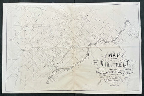
1868 Wrigley Rare Antique Oilfield Map of Petroleum Centre Area, NW Pennsylvania
- Title : Map of the Oil Belt Southwest from Shamburg and Petroleum Center to Charley Run. Henry E Wrigley Civil Engineer & Surveyor Titusville PA Oct 1868
- Ref #: 93523
- Size: 29 1/2in x 19 1/2in (740mm x 485mm)
- Date : 1868
- Condition: (A) Very Good Condition
Description:
This large original rare lithograph antique oilfield map, one of the first ever published, of the area of Titusville, Oil Creek, Petroleum Centre and Cherrytree in NW Pennsylvania, by Henry Wrigley in 1868 - dated - was published by P S Duval & Sons, Philadelphia.
The map illustrates and names the farms and leases of the area directly related to oil exploration & production.
Petroleum Center is located in Cornplanter Township, Venango County, Pennsylvania, United States.
As the name implies, Petroleum Center was developed during the Pennsylvanian oil rush of the mid-19th century. The first well was drilled on the George Washington McClintock Farm in 1860. Soon a small community grew about half way between Oil City and Titusville. George Henry Bissell, James Bishop and others formed the Central Petroleum Company which owned the farm in the beginning of 1866 when daily production topped 1,000 barrels per day. By the summer of 1866, over 3,000 people called the Centre home with a bank, two churches, a theater, a half-dozen hotels/boarding houses, and stores serving all the needs of the growing community. Bissel & Co. Banking House stimulated economic growth with its direct ties to financial institutions in New York City. President Ulysses S. Grant visited the town in 1871. When a fire devastated the nearby town of Pithole, Pennsylvania, that town's newspaper, the Pithole Daily Record, was relocated to Petroleum Center. The town was founded in 1866 and was essentially abandoned after 1873.
General Definitions:
Paper thickness and quality: - Light and stable
Paper color : - off white
Age of map color: - Original
Colors used: -
General color appearance: -
Paper size: - 29 1/2in x 19 1/2in (740mm x 485mm)
Plate size: - 29 1/2in x 19 1/2in (740mm x 485mm)
Margins: - Min 1/2in (12mm)
Imperfections:
Margins: - Folds as issued
Plate area: - Folds as issued, creasing along folds
Verso: - Folds as issued, several folds re-enforced with archival transparent tape.
Background:
The oil rush in America started in Titusville, Pennsylvania, in the Oil Creek Valley when Edwin L. Drake struck rock oil there in 1859. Titusville and other towns on the shores of Oil Creek expanded rapidly as oil wells and refineries shot up across the region. Oil quickly became one of the most valuable commodities in the United States and railroads expanded into Western Pennsylvania to ship petroleum to the rest of the country.
By the mid-1870s, the oil industry was well established, and the rush to drill wells and control production was over. Pennsylvania oil production peaked in 1891, and was later surpassed by western states such as Texas and California, but some oil industry remains in Pennsylvania.
With petroleum seeps popping up across western Pennsylvania, it became difficult for other extractive industries, especially for salt water wells to extract salt. This business was popular in the area at the time but with oil from the seeps spilling into the wells, it became much more difficult. In 1849 Samuel Kier began extracting oil from the saltwater wells on his property. Upon further examination, Kier recognized that the medicinal oil being prescribed to his wife was the same in chemistry as the oil found in his wells. Kier sold his oil as a remedy and grew wealthy. Other uses for Kiers oil were explored.
In the 1850s Kier began to drill for crude oil rather than separating it from salt water. After extracting the oil from drilling, Kier joined up with John T. Kirkpatrick to build the first refinery. Soon Kier and Kirkpatrick distilled oil that could be used for lighting. For years after, Kier improved the crude oil refining process to produce the cleanest and most efficient lighting oil. He called his oil carbon oil. To accompany his refined oil, Kier invented an oil-burning lamp that burned his oil with little bad odor or smoke. This could have been profitable to Kier, but he never patented his lamp.
News of Kiers experiments spread, and George Bissell, a lawyer from New York, learned of Kiers success. In 1854, Bissell commissioned a study from Yale chemist Benjamin Silliman, Jr. to assess the viability of harvesting oil in western Pennsylvania. After Sillimans results confirmed that the petroleum in the Oil Creek Valley could profitably be distilled into lamp oil, Bissell founded the Pennsylvania Rock Oil Company. The company was funded by businessmen and bankers from New Haven, Connecticut. Among the stockholders was banker James Townsend.
In 1857 Bissell and Townsend hired Edwin Drake to travel to Titusville and drill for crude oil. Drake was an unemployed railroad conductor whose sole qualification for this job seems to have been a free railroad pass that allowed travel to Titusville. Drake secured some land and reported back that he believed the land was oil rich and the oil industry could be extremely profitable. In 1858, the Pennsylvania Rock Oil Company became the Seneca Oil Company with Drake as president.
Soon Drake began drilling for oil in Titusville, near the shores of Oil Creek, but at first met with little success. He used an old steam engine to drill. Many of his drilling sites only yielded trace amounts of oil. He and his assistant, blacksmith Billy Smith, endured fires, financial setbacks, and the ridicule of the local inhabitants. When the Seneca Oil Company gave up and decided to withdraw its funding, Drake obtained a personal line of credit to continue digging. On August 27, 1859, Drake struck oil at 69 feet (21 m) below ground, just before his funds ran out. This marked the beginning of drastic change for the people of Western Pennsylvania. His drilling is considered the first large-scale commercial extraction of petroleum.
Unfortunately for Drake, his success would not last. He had not purchased much land in the region, and the oil industry exploded around him outside of his control. His first well yielded only modest returns and he was fired by Seneca. He never patented the drilling method he pioneered, and lost his modest earnings from the oil business speculating on Wall Street. He would eventually die a poor pensioner in 1880.
Soon the area had many wells drilled by Seneca Oil Company and others. The oil boom in Pennsylvania paralleled in many ways the gold rush in California ten years earlier. It is reported that in the first year (1859), these wells produced 4,500 barrels (720 m3) . Boomtowns such as Titusville, Oil City and Pithole sprang up within years and an early chronicler of the region, Reverend S. J. M. Eaton, observed in 1866 that the Oil Creek Valley was so densely packed it was impossible to distinguish the borders where one town ended and another began. The Titusville population exploded from 250 residents to over 10,000 in little more than five years and in 1866 it incorporated as a city. Ironworks were erected to supply drilling tools and eight oil refineries were built between 1862 and 1868. Pithole expanded from four log-cabin farmhouses to a bustling city with over 50 hotels over the span of five months in 1865.
Annual domestic output of crude swelled from 2,000 barrels (320 m3) in 1859, the year of Drakes discovery, to 4,000,000 barrels (640,000 m3) in 1869 and 10,000,000 barrels (1,600,000 m3) in 1873. The ongoing industrial development of Europe spurred this rapid expansion. European, and especially British, factories began importing large quantities of cheap American oil during the 1860s. By 1866, US petroleum exports far surpassed petroleum distributed to domestic markets and the value of these exports nearly doubled from $16 million in 1865 to $30 million in 1869. Petroleum jumped from the sixth most valuable US export to the second most valuable during this period. At the peak of the oil boom, Pennsylvania wells were producing one third of the worlds oil.
The rush to Pennsylvania created violent swings in the petroleum market for the first decade of the oil boom. In 1861, the proliferation of wells across the Oil Creek Valley pushed the price of oil down from $10 a barrel to 10 cents a barrel. In response, producers in the region formed the Oil Creek Association to restrict output and maintain a minimum price of $4 a barrel. Despite efforts such as this to control the petroleum market, the volatile boom-bust cycle continued into the early 1870s. By 1871, refining capacity had grown to over 12 million barrels per year, more than twice the amount of oil that was actually processed in that year. The first oil exchange in the US was established in Titusville in January 1872 in response to rumors that a conspiratorial ring of crude oil traders in New York City had cornered the market. As the decade progressed, larger producers, such as John D. Rockefellers Standard Oil, began to consolidate their holdings over the wells and refineries in the region, and the oil rush began to settle down.
Pennsylvania oil production peaked in 1891, when the state produced 31 million barrels of oil, 58% of the nations oil that year. But 1892 was the last year that Pennsylvania wells provided a majority of the oil produced in the US, and in 1895, Ohio surpassed Pennsylvania as an oil producer. By 1907, the decline of the Pennsylvania fields and the great discoveries made in Texas, California, and Oklahoma, left Pennsylvania with less than 10% of the nations oil production.
By 1901, the Pennsylvania oil boom was over. The formation of the Standard Oil Trust in 1882 effectively established a monopoly over the industry in Pennsylvania, and the discovery of oil in Texas, California and Wyoming shifted the nations attention elsewhere. Pennsylvania continued to be a significant producer of petroleum for much of the 20th century, but the Oil Creek Valley had been permanently eclipsed.
Please note all items auctioned are genuine, we do not sell reproductions. A Certificate of Authenticity (COA) can be issued on request.
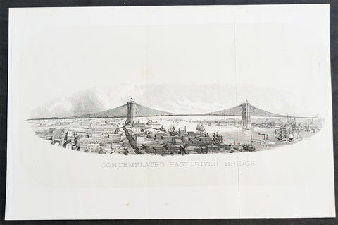
1869 DT Valentine Antique Print of the Proposed East River or Brooklyn Bridge NY
- Title : Contemplated East River Bridge
- Size: 11in x 7 1/2in (280mm x 190mm)
- Condition: (A+) Fine Condition
- Date : 1869
- Ref #: 93310
Description:
This original antique lithograph print, a view of the proposed Brooklyn Bridge in 1869 by George Hayward was published in the 1869 edition of D T Valentines Manual of the Corporation of the City of New York or Valentines Manual.
The Brooklyn Bridge started construction in 1869 and was completed fourteen years later in 1883. It was originally called the New York and Brooklyn Bridge and the East River Bridge, but it was later dubbed the Brooklyn Bridge. However, it was not named as such until the city government passed a law to that effect in 1915. Over the years, the Brooklyn Bridge has undergone several reconfigurations; it formerly carried horse-drawn vehicles and elevated railway lines, but now carries vehicular, pedestrian, and bicycle traffic. Commercial vehicles are banned from the bridge.
General Definitions:
Paper thickness and quality: - Heavy and stable
Paper color : - off white
Age of map color: -
Colors used: -
General color appearance: -
Paper size: - 11in x 7 1/2in (280mm x 190mm)
Plate size: - 11in x 7 1/2in (280mm x 190mm)
Margins: - Min 1/2in (12mm)
Imperfections:
Margins: - None
Plate area: - Folds as issued
Verso: - None
Background:
Manual of the Corporation of the City of New York or Valentines Manuals, published for nearly 30 years, contained hundreds of rare beautifully hand coloured contemporary and historical lithograph maps and views of New York City.
Valentine, David Thomas 1801 - 1869
As the Clerk of the Common Council of New York City, Valentine edited and published a series of books on the history and contemporary facts of New York City entitled Manual of the Corporation Of The City of New York. They became know as Valentines Manuals with updates published annually, between 1841 & 1870. Valentine used his manuals to produce some of the rarest and most important maps & views of the city of New York, some of which occasionally appear on the market. His contribution to the historical record of New York city cannot be over stated.
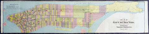
1869 DT Valentine Large Antique Map of New York City
- Title : 1869 DT Valentine Large Antique Map of New York City
- Size: 39in x 9in (990mm x 230mm)
- Condition: (A+) Fine Condition
- Date : 1869
- Ref #: 93209
Description:
This large original antique lithograph map of the political divisions of New York city, printed on both sides, by George Hayward was published in the 1869 edition of D T Valentines Manual of the Corporation of the City of New York or Valentines Manual.
General Definitions:
Paper thickness and quality: - Heavy and stable
Paper color : - off white
Age of map color: - Original
Colors used: - Blue, pink, red, green, yellow
General color appearance: - Authentic
Paper size: - 39in x 9in (990mm x 230mm)
Plate size: - 39in x 9in (990mm x 230mm)
Margins: - Min 1/4in (2mm)
Imperfections:
Margins: - None
Plate area: - Folds as issued
Verso: - Folds as issued
Valentine, David Thomas 1801 - 1869
As the Clerk of the Common Council of New York City, Valentine edited and published a series of books on the history and contemporary facts of New York City entitled Manual of the Corporation Of The City of New York. They became know as Valentines Manuals with updates published annually, between 1841 & 1870. Valentine used his manuals to produce some of the rarest and most important maps & views of the city of New York, some of which occasionally appear on the market. His contribution to the historical record of New York city cannot be over stated.
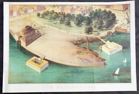
1869 DT Valentine Large Antique Print, View of The Battery, Park, New York City
- Title : The Battery, 1869
- Size: 13 1/2in x 9 1/2in (345mm x 240mm)
- Condition: (A+) Fine Condition
- Date : 1869
- Ref #: 93210
Description:
This original antique coloured lithograph print of The Battery (Battery Park) New York City by George Hayward was published in the 1869 edition of D T Valentines Manual of the Corporation of the City of New York or Valentines Manual.
General Definitions:
Paper thickness and quality: - Heavy and stable
Paper color : - off white
Age of map color: - Original
Colors used: - Blue, pink, red, green, yellow
General color appearance: - Authentic
Paper size: - 13 1/2in x 9 1/2in (345mm x 240mm)
Plate size: - 13 1/2in x 9 1/2in (345mm x 240mm)
Margins: - Min 1/2in (12mm)
Imperfections:
Margins: - Bottom right margin extended, not affecting the image
Plate area: - Folds as issued
Verso: - Folds as issued
Background:
The Battery (formerly known as Battery Park) is a 25-acre public park located at the southern tip of Manhattan Island in New York City facing New York Harbor. It is bounded by Battery Place on the north, State Street on the east, New York Harbor to the south, and the Hudson River to the west. The park contains attractions such as an old fort named Castle Clinton; multiple monuments; and the SeaGlass Carousel. The surrounding area, known as South Ferry, contains multiple ferry terminals, including the Staten Island Ferry\'s Whitehall Terminal as well as boat launches to the Statue of Liberty National Monument.
The park and surrounding area is named for the artillery batteries that were built in the late 17th century to protect the settlement behind them. By the 1820s, the Battery had become an entertainment destination, with the conversion of Castle Clinton into a theatre venue. During the mid-19th century, the modern-day Battery Park was constructed and Castle Clinton was converted into an immigration and customs center. The Battery was commonly known as the landing point for immigrants to New York City until 1890, when the Castle Clinton immigration center was replaced by one on Ellis Island. Castle Clinton then hosted the New York Aquarium from 1896 to 1941.
Valentine, David Thomas 1801 - 1869
As the Clerk of the Common Council of New York City, Valentine edited and published a series of books on the history and contemporary facts of New York City entitled Manual of the Corporation Of The City of New York. They became know as Valentines Manuals with updates published annually, between 1841 & 1870. Valentine used his manuals to produce some of the rarest and most important maps & views of the city of New York, some of which occasionally appear on the market. His contribution to the historical record of New York city cannot be over stated.
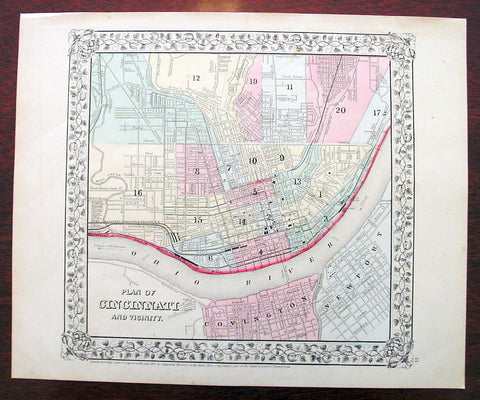
1869 Mitchell Antique Map - Plan of The City of Cincinnati
- Title : Plan of Cincinnati and Vicinity....1869 by S. Augustus Mitchell
- Ref #: 35044
- Size: 15in x 12in (380mm x 300mm)
- Date : 1870
- Condition: (A+) Fine Condition
Description:
This beautifully hand coloured original antique city plan map was published by Samuel Augustus Mitchell in the 1870 edition of his large New General Atlas - dated at the foot of the map.
These county, state, city & country maps are some of the most ornate and beautifully coloured maps published in the US in the 19th century. For over 50 years, Mitchell his son's and their successors were the most prominent cartographical publishers of maps and atlases in the United States.
General Description:
Paper thickness and quality: - Heavy & stable
Paper color: - White
Age of map color: - Original
Colors used: - Green, pink, yellow
General color appearance: - Authentic
Paper size: - 15in x 12in (380mm x 300mm)
Plate size: - 15in x 12in (380mm x 300mm)
Margins: - Min 1/2in (10mm)
Imperfections:
Margins: - None
Plate area: - None
Verso: - None
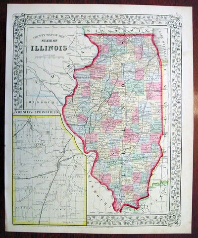
1869 Mitchell Antique Map of The State of Illinois
- Title : County Map of the State of Illinois....1869 by S. Augustus Mitchell
- Ref #: 35045
- Size: 15in x 12in (380mm x 300mm)
- Date : 1870
- Condition: (A+) Fine Condition
Description:
This beautifully hand coloured original antique map was published by Samuel Augustus Mitchell in the 1870 edition of his large New General Atlas - dated at the foot of the map.
These county, state, city & country maps are some of the most ornate and beautifully coloured maps published in the US in the 19th century. For over 50 years, Mitchell his son's and their successors were the most prominent cartographical publishers of maps and atlases in the United States.
General Description:
Paper thickness and quality: - Heavy & stable
Paper color: - White
Age of map color: - Original
Colors used: - Green, pink, yellow
General color appearance: - Authentic
Paper size: - 15in x 12in (380mm x 300mm)
Plate size: - 15in x 12in (380mm x 300mm)
Margins: - Min 1/2in (10mm)
Imperfections:
Margins: - None
Plate area: - None
Verso: - None
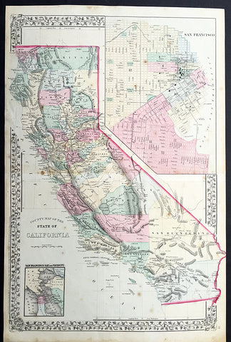
1869 Mitchell Large Antique Map of California
- Title : County Map of The State of California
- Date : 1869
- Condition: (A) Very Good Condition
- Ref: 35056
- Size: 23in x 15in (580mm x 390mm)
Description:
This large two page beautifully hand coloured original antique map of California - with inset maps plan of San Francisco & San Francisco Bay - was published by Samuel Augustus Mitchell in the 1869 edition of his large New General Atlas - dated at the foot of the map.
These county, state, city & country maps are some of the most ornate and beautifully coloured maps published in the US in the 19th century. For over 50 years, Mitchell his son's and their successors were the most prominent cartographical publishers of maps and atlases in the United States.
General Description:
Paper thickness and quality: - Heavy and stable
Paper color: - off white
Age of map color: - Original
Colors used: - Yellow, green, red, brown.
General color appearance: - Authentic and fresh
Paper size: - 23in x 15in (580mm x 390mm)
Plate size: - 23in x 15in (580mm x 390mm)
Margins: - Min ½in (12mm)
Imperfections:
Margins: - Light soiling, small repairs to margins, no loss
Plate area: - Light spotting
Verso: - Light spotting
1869 Shannon & Rogers Birds Eye View of New York City - New York Manual
- Title : Designed and Engraved For New York and Environs. The New York Manual 1869
- Size: 16in x 12in (405mm x 275mm)
- Condition: (A+) Fine Condition
- Date : 1869
- Ref #: 93208
Description:
This original antique lithograph print of New York City by Joseph Shannon & WC Rogers in 1869 (dated) and was published in the 1869 edition of D T Valentines Manual of the Corporation of the City of New York or Valentines Manual.
General Definitions:
Paper thickness and quality: - Heavy and stable
Paper color : - off white
Age of map color: -
Colors used: -
General color appearance: -
Paper size: - 16in x 12in (405mm x 275mm)
Plate size: - 16in x 12in (405mm x 275mm)
Margins: - Min 1/2in (12mm)
Imperfections:
Margins: - Bottom right margin extended, not affecting the image
Plate area: - Folds as issued
Verso: - Folds as issued.
Background:
Rare view of the island of Manhattan, New York City by W. C. Rogers. The view depicts the entire island of Manhattan with Hoboken as well as parts of Brooklyn and Queens. Important buildings, especially churches are depicted with considerable accuracy. The harbor itself is full of sailing ships.
William C. Rogers 1860 - 1873 (active) a New York based lithographer best known for his engravings issued in conjuction with Joseph Shannons (Valentines) Manual of the Corporation for the City of New York.
Valentine, David Thomas 1801 - 1869
As the Clerk of the Common Council of New York City, Valentine edited and published a series of books on the history and contemporary facts of New York City entitled Manual of the Corporation Of The City of New York. They became know as Valentines Manuals with updates published annually, between 1841 & 1870. Valentine used his manuals to produce some of the rarest and most important maps & views of the city of New York, some of which occasionally appear on the market. His contribution to the historical record of New York city cannot be over stated.
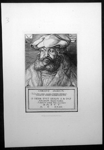
1870 Amand-Durand after Albrecht Durer Antique Print - Frederick III of Saxony
- Title : Christo Sacrum.....Fridr Dvci Saxon....Albertus Durer....MDXXIIII
- Size: 13 1/2in x 9 1/2in (345mm x 240mm)
- Condition: (A+) Fine Condition
- Date : 1870
- Ref #: 22401
Description:
This fine, original antique wood-cut print of the protector of Martin Luther, Frederick the Wise of Saxony, by the famous German engraver Albrecht Dürer in 1496 was faithfully re-engraved and published by Charles Amand-Durand in 1870.
These beautiful re-engravings of classic and historical wood-cuts were painstakingly re-issued by Amand-Durand in Paris in the mid to late 19th century. Such is the quality of his re-strikes that Durands prints are now in major institutional collections such a the Louvre, National Gallery, The Met and many other famous Galleries. Please see below for further background on Amand-Durand.
General Definitions:
Paper thickness and quality: - Heavy and stable
Paper color : - off white
Age of map color: -
Colors used: -
General color appearance: -
Paper size: - 14in x 9 1/2in (350mm x 240mm)
Plate size: - 8in x 6in (205mm x 1530mm)
Margins: - Min 1in (25mm)
Imperfections:
Margins: - None
Plate area: - None
Verso: - None
Background:
Albrecht Dürer 1471 – 1528 was a painter, printmaker, and theorist of the German Renaissance. Born in Nuremberg, Dürer established his reputation and influence across Europe when he was still in his twenties due to his high-quality woodcut prints. He was in communication with the major Italian artists of his time, including Raphael, Giovanni Bellini and Leonardo da Vinci, and from 1512 he was patronized by emperor Maximilian I. Dürer is commemorated by both the Lutheran and Episcopal Churches.
Dürer\'s vast body of work includes engravings, his preferred technique in his later prints, altarpieces, portraits and self-portraits, watercolours and books. The woodcuts, such as the Apocalypse series (1498), are more Gothic than the rest of his work. His well-known engravings include the Knight, Death, and the Devil (1513), Saint Jerome in his Study (1514) and Melencolia I (1514), which has been the subject of extensive analysis and interpretation. His watercolours also mark him as one of the first European landscape artists, while his ambitious woodcuts revolutionized the potential of that medium.
Dürer\'s introduction of classical motifs into Northern art, through his knowledge of Italian artists and German humanists, has secured his reputation as one of the most important figures of the Northern Renaissance. This is reinforced by his theoretical treatises, which involve principles of mathematics, perspective, and ideal proportions.
The Portrait of Frederick III of Saxony is a tempera on canvas painting by German Renaissance artist Albrecht Dürer, executed in 1496. It is housed in the Gemäldegalerie of Berlin, Germany.
The painting was one of the first commissions received from Frederick III, Elector of Saxony, together with the Seven Sorrows Polyptych and the central panel of the Dresden Altarpiece. Dürer knew the elector during the latter\'s short stay in Nuremberg in April 1496.
The German artist portrayed the Elector again in a burin etching in 1524.
Dürer portrayed Fredericks bust from three-quarters, looking right, above a dark green background. Elements such as the parapet on which his arms lie, or the hands holding a roll, were typical of Flemish art of the period.
Frederick\'s impervious personality, as well as his status, are emphasized by the large beret and by his determined glance.
Frederick III 1463 – 1525, also known as Frederick the Wise (German Friedrich der Weise) was Elector of Saxony from 1486 to 1525, who is mostly remembered for the worldly protection of his subject Martin Luther.
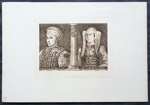
1870 Amand-Durand after Baccio Baldini Antique Print Ludovico Gonzaga III & Wife
- Title : Ludovico Gonzaga III and his Wife
- Date : 1870
- Condition: (A+) Fine Condition
- Ref: 22042
- Size: 13 1/2in x 9 1/2in (345mm x 240mm)
Description:
This fine, original antique Heliograph of Ludovico Gonzaga III and his Wife, Barbara of Brandenburg, by the Italian engraver Andrea Mantegna in the 15th century was re-engraved and published by Charles Amand-Durand in 1870.
These faithful re-engravings of classic and historical wood-cuts were faithfully re-issued by Amand-Durand in Paris in the mid to late 19th century. Such is the quality of his re-strikes that Durands prints are now in major institutional collections such a the Louvre, National Gallery, The Met and many other famous Galleries. Please see below for further background on Amand-Durand.
General Definitions:
Paper thickness and quality: - Heavy and stable
Paper color : - off white
Age of map color: -
Colors used: -
General color appearance: -
Paper size: - 13 1/2in x 9 1/2in (345mm x 240mm)
Plate size: - 8in x 6in (205mm x 1530mm)
Margins: - Min 1in (25mm)
Imperfections:
Margins: - None
Plate area: - None
Verso: - None
Background:
Andrea Mantegna 1431 – 1506 was an Italian painter, a student of Roman archeology, and son-in-law of Jacopo Bellini. Like other artists of the time, Mantegna experimented with perspective, e.g. by lowering the horizon in order to create a sense of greater monumentality. His flinty, metallic landscapes and somewhat stony figures give evidence of a fundamentally sculptural approach to painting. He also led a workshop that was the leading producer of prints in Venice before 1500.
Mantegna was no less eminent as an engraver, though his history in that respect is somewhat obscure, partly because he never signed or dated any of his plates, but for a single disputed instance of 1472. The account which has come down to us from Vasari (as usual keen to assert that everything flows from Florence) is that Mantegna began engraving in Rome, prompted by the engravings produced by the Florentine Baccio Baldini after Sandro Botticelli. This is now considered most unlikely as it would consign all the numerous and elaborate engravings made by Mantegna to the last sixteen or seventeen years of his life, which seems a scanty space for them, and besides the earlier engravings indicate an earlier period of his artistic style. He may have begun engraving while still in Padua, under the tuition of a distinguished goldsmith, Niccolò. He and his workshop engraved about thirty plates, according to the usual reckoning; large, full of figures, and highly studied. It is now considered either that he only engraved seven himself, or none. Another artist from the workshop who made several plates is usually identified as Giovanni Antonio da Brescia (aka Zoan Andrea).
Among the principal examples are: Battle of the Sea Monsters, Virgin and Child, a Bacchanal Festival, Hercules and Antaeus, Marine Gods, Judith with the Head of Holophernes, the Deposition from the Cross, the Entombment, the Resurrection, the Man of Sorrows, the Virgin in a Grotto, and several scenes from the Triumph of Julius Caesar after his paintings. Several of his engravings are supposed to be executed on some metal less hard than copper. The technique of himself and his followers is characterized by the strongly marked forms of the design, and by the parallel hatch marks to produce shadows. The closer the parallel marks, the darker the blacks were. The prints are frequently to be found in two states, or editions. In the first state the prints have been taken off with the roller, or even by handpressing, and they are weak in tint; in the second state the printing press has been used, and the ink is stronger.
Neither Mantegna or his workshop are now believed to have produced the so-called Mantegna Tarocchi cards.
Ludovico III Gonzaga of Mantua, also spelled Lodovico 1412 – 1478 was the ruler of the Italian city of Mantua from 1444 to his death in 1478.
Ludovico was the son of Gianfrancesco I Gonzaga and Paola Malatesta.
Ludovico followed the path of his father, Gianfrancesco, fighting as a condottiero from as early as 1432, when Gianfrancesco was vice-commander of Francesco Bussone\'s army. In 1433, he married Barbara of Brandenburg, niece of emperor Sigismund.
Starting from 1436 (perhaps without the approval of his father) he entered the service of the Visconti of the Duchy of Milan. The result was that Gianfrancesco exiled Ludovico from Mantua, together with his wife, naming Carlo Gonzaga as heir. However, in 1438 Gianfrancesco himself was hired by the Visconti, and reconciled with Ludovico in 1441. Ludovico succeeded to the marquisate of Mantua in 1444, although part of the family fiefs went to his brothers Carlo, Gianlucido and Alessandro. At the time, the Mantuan state was reduced in size and in poor conditions after years of war and large expenses.
From 1445 to 1450 Ludovico served as condottiero for Milan, Florence, Venice and Naples, switching his allegiance in order to grant the higher level of peace for his lands. In 1448 he took part in the battle of Caravaggio, and was forced to flee. In 1449 he entered the service of Venice in the league formed with Florence against Milan. In 1450 he received permission to lead an army for King Alfonso of Naples in Lombardy, with the intent of gaining some possessions for himself. However, Francesco Sforza, the new duke of Milan, enticed him with the promise of Lonato, Peschiera and Asola, formerly Mantuan territories but then part of Venice. Venice responded by sacking Castiglione delle Stiviere (1452) and hiring Ludovico\'s brother, Carlo.
On 14 June 1453 Ludovico routed the troops of Carlo at Goito, but Venetian troops under Niccolò Piccinino thwarted any attempt to regain Asola. The Peace of Lodi (1454) obliged Ludovico to give back all his conquests, and to renounce definitively his claim to the three cities. However, he obtained his brother\'s land after Carlos childless death in 1456.
The moment of highest prestige for Mantua was the Council, held in the city from 27 May 1459 to 19 January 1460, summoned by Pope Pius II to launch a crusade against the Ottoman Turks, who had conquered Constantinople some years earlier. However, the pope was not satisfied with the host city, writing: The place was marshy and unhealthy, and the heat burnt up everything; the wine was unpalatable and the food unpleasant. However, the council ended on a note of great personal prestige for Ludovico with the elevation of his son Francesco to the purple.
From 1466 Ludovico was more or less constantly at the service of the Sforza of Milan. He died in Goito in 1478, during a plague. He was buried in Mantua cathedral
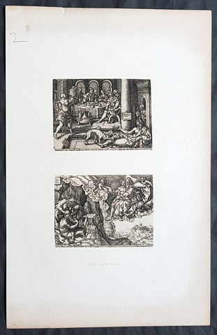
1870 Amand-Durand after Heinrich Aldegrever Antique Print - Parable of Lararus
- Title : Erumnos hic lazar iages ad ianva divitis/Dives epvlo elamis
- Date : 1870
- Condition: (A+) Fine Condition
- Ref: 22444
- Size: 13 1/2in x 9 1/2in (345mm x 240mm)
Description:
This fine, original antique Heliograph two panels of the parable of The Rich Man and Lazarus or Dives and Lazarus or Lazarus and Dives by the German engraver Heinrich Aldegrever or Aldegraf in the early 16th century was re-engraved and published by Charles Amand-Durand in 1870.
These faithful re-engravings of classic and historical wood-cuts were faithfully re-issued by Amand-Durand in Paris in the mid to late 19th century. Such is the quality of his re-strikes that Durands prints are now in major institutional collections such a the Louvre, National Gallery, The Met and many other famous Galleries. Please see below for further background on Amand-Durand.
General Definitions:
Paper thickness and quality: - Heavy and stable
Paper color : - off white
Age of map color: -
Colors used: -
General color appearance: -
Paper size: - 13 1/2in x 9 1/2in (345mm x 240mm)
Plate size: - 8in x 6in (205mm x 1530mm)
Margins: - Min 1in (25mm)
Imperfections:
Margins: - None
Plate area: - None
Verso: - None
Background:
Heinrich Aldegrever or Aldegraf (1502–1561) was a German painter and engraver. He was one of the Little Masters, the group of German artists making small old master prints in the generation after Dürer.
Painter, printmaker and goldsmith active in a Westphalia milieu. Born in Paderborn. His real name was Trippenmecker, which in Westphalian dialect means a clog-maker. It is not known where Aldegrever was taught. He probably worked in a workshop of one of the Soest goldsmiths. His early works show a strong Westphalian influence. Aldegrever made a journey to the Netherlands, where he became acquainted with works of Joos van Cleve, Barendt van Orley, Lucas van Leyden and Jacob Cornelisz.
Around 1525 he moved to Soest, where a year later he painted the wings and predella of the Mary altar for the church of St. Peter. His signature and symbolic clog show that he was still using his fathers name.
His first engravings appeared in 1527. They were signed with a monogram AG, resembling closely that of Albrecht Dürer. In 1531, influenced by surrounding religious fervour, he became a Lutheran. Because of lack of church commissions he devoted most of his time to portrait painting and printmaking. Aldegrevers some 290 engravings and woodcuts, chiefly from his own designs, are delicate and minute, though somewhat hard in style, and entitle him to a place in the front rank of the so-called Little Masters: Barthel Beham, his brother Hans Sebald Beham, and Georg Pencz, with whom he is often compared. Like them, he was also a skilled ornament designer. From the close resemblance of his style to that of Albrecht Dürer he has also sometimes been called the Albert of Westphalia.
About a third of his prints were ornamental engravings; they were used as models by artists and craftsmen well into the seventeenth century.
Aldegrever, who actively supported the Reformation, executed portraits of Martin Luther and Philip Melanchthon. Although he chose the Lutheran Church, he had friends among the Anabaptists. He was commissioned by the bishop of Münster in 1535–36 to engrave portraits of Anabaptist leaders Jan van Leyden and Bernhard Knipperdolling, although they were already imprisoned, and only caricatures of them circulated. In the cycle Power of Death, done under visible influence of Hans Holbein, he criticizes the vices of the Catholic Church.
Aldegrever was interested also in folk subjects. In 1538 and 1551 two series of prints depicting marriage dances were made. An important part of his oeuvre are prints on mythological subjects, the Deeds of Hercules being one of the best examples.
Only two paintings are firmly attributed to him: the wings and predella of the Marienaltar (c. 1525-6) in the Wiesenkirche in Soest, and a portrait of Graf Phillip von Waldeck (1837) in Schloss Aroldsen
The parable of the rich man and Lazarus(also called the Dives and Lazarus or Lazarus and Dives) is a well-known parable of Jesus appearing in the Gospel of Luke.
The Gospel of Luke (Luke 16:19–31) tells of the relationship, during life and after death, between an unnamed rich man and a poor beggar named Lazarus. The traditional name Dives is not actually a name, but instead a word for rich man, dives in the text of the Latin Bible, the Vulgate. The rich man was also given the names Neuēs (i.e. Nineveh) and Fineas (i.e. Phineas) in the 3rd and 4th centuries.
Along with the parables of the Ten Virgins, Prodigal Son, and Good Samaritan, it was one of the most frequently illustrated parables in medieval art, perhaps because of its vivid account of an afterlife.
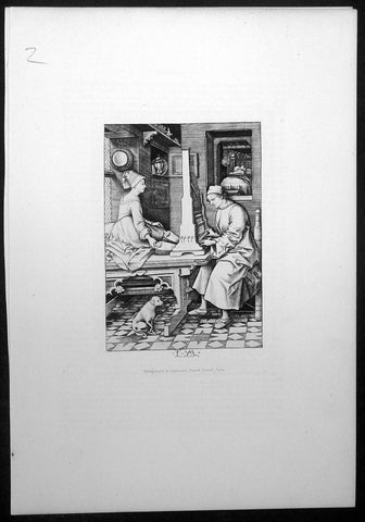
1870 Amand-Durand after Israhel van Meckenem Antique Print - Organ Player & Wife
- Title : The Organ player and his Wife
- Size: 13 1/2in x 9 1/2in (345mm x 240mm)
- Condition: (A+) Fine Condition
- Date : 1870
- Ref #: 22404
Description:
This fine, original antique wood-cut print of The Organ player and wife by Israhel van Meckenem in late 15th century was faithfully re-engraved and published by Charles Amand-Durand in 1870.
These beautiful re-engravings of classic and historical wood-cuts were painstakingly re-issued by Amand-Durand in Paris in the mid to late 19th century. Such is the quality of his re-strikes that Durands prints are now in major institutional collections such a the Louvre, National Gallery, The Met and many other famous Galleries. Please see below for further background on Amand-Durand.
General Definitions:
Paper thickness and quality: - Heavy and stable
Paper color : - off white
Age of map color: -
Colors used: -
General color appearance: -
Paper size: - 14in x 9 1/2in (350mm x 240mm)
Plate size: - 8in x 6in (205mm x 1530mm)
Margins: - Min 1in (25mm)
Imperfections:
Margins: - None
Plate area: - None
Verso: - None
Background:
This husband-and-wife duo performs an intimate domestic concert, jointly playing a diminutive pipe organ with four stops. The wife operates the two bellows in time to the music, giving voice to the notes, while her husband creates the melody on the keyboard. He is clad in a housecoat and comfortable slippers and she wears a cozy fur-trimmed dress. Shown at the same scale and working in tandem, they symbolize a harmonious marriage. The little dog listening attentively is both an emblem of loyalty and a realistic detail of their well-to-do home.
Israhel van Meckenem (c.1445 – 10 November 1503), also known as Israhel van Meckenem the Younger, was a German printmaker and goldsmith, perhaps of a Dutch family origin.
He was the most prolific engraver of the fifteenth century and an important figure in the early history of old master prints. He was active from 1465 until his death.
He probably trained with Master E. S. in South Germany, and may well have been with him at his death c. 1467, since he acquired and reworked forty-one of the master\'s plates. Another two hundred of van Meckenem\'s own prints also were copies of ones by Master E. S. In total, he produced over six hundred plates, most of which were copies of other prints; they represent about 20% of print production by all Northern European artists in the period of his working life. His career lasted long enough for him to copy Dürer prints.
He copied prints by the Housebook Master, including some now otherwise lost, Martin Schongauer, and many other German engravers. His famous and very fine late series on the Life of the Virgin appears to have been based on drawings by Hans Holbein the Elder or his workshop, and he may have entered into a regular commercial relationship with Holbein.
His early works were fairly crude, but in the 1480s he developed an effective personal style and made increasingly large and finished works. His own compositions are often very lively, and take a great interest in the secular life of his day. One famous print, supposed to illustrate the story of St John the Baptist and Salome, pushes the specific incidents of the story far in the background to allow space for a scene of court dancers, dressed in the height of contemporary fashion, which takes up most of the plate.
He was sophisticated in self-presentation, signing later prints with his name and town, and producing the first self-portrait print of himself and his wife, which was also the first portrait print of an identifiable person. Some plates seem to have been reworked more than once by his workshop, or produced in more than one version, and many impressions have survived, so his ability to distribute and sell his prints was evidently equally well developed. He was apparently the first to issue engraved (as opposed to woodcut) indulgences, apparently bootlegged version[s] ... never subject to papal review; one print promises 20,000 years reduction of time in Purgatory per set of prayers, increased in a second state to 45,000 years.
In the Heures de Charles d\'Angoulême, an important manuscript showing the links between printmaking and illumination in the late 15th century, Robinet Testard incorporated sixteen of van Meckenem\'s prints, gluing them directly on to the vellum then overpainting.
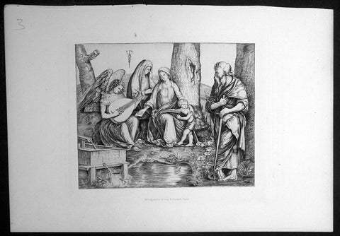
1870 Amand-Durand after Jacapo de Barbari Antique Print Holy Family w/ St Paul
- Title : Holy Family with St. Anne, St. Paul and Lute-Playing Angel
- Size: 13 1/2in x 9 1/2in (345mm x 240mm)
- Condition: (A+) Fine Condition
- Date : 1870
- Ref #: 22408
Description:
This fine, original antique wood-cut print of Holy Family with St Paul by Jacapo de Barbari in the early 16th century was faithfully re-engraved and published by Charles Amand-Durand in 1870.
These beautiful re-engravings of classic and historical wood-cuts were painstakingly re-issued by Amand-Durand in Paris in the mid to late 19th century. Such is the quality of his re-strikes that Durands prints are now in major institutional collections such a the Louvre, National Gallery, The Met and many other famous Galleries. Please see below for further background on Amand-Durand.
General Definitions:
Paper thickness and quality: - Heavy and stable
Paper color : - off white
Age of map color: -
Colors used: -
General color appearance: -
Paper size: - 14in x 9 1/2in (350mm x 240mm)
Plate size: - 8in x 6in (205mm x 1530mm)
Margins: - Min 1in (25mm)
Imperfections:
Margins: - None
Plate area: - None
Verso: - None
Background:
Jacopo de Barbari sometimes known or referred to as de Barbari, de Barberi, de Barbari, Barbaro, Barberino, Barbarigo or Barberigo (1460/70 – 1516), was an Italian painter and print-maker with a highly individual style. He moved from Venice to Germany in 1500, thus becoming the first Italian Renaissance artist of stature to work in Northern Europe. His few surviving paintings (about twelve) include the first known example of trompe l oeil since antiquity. His twenty-nine engravings and three very large woodcuts were also highly influential.
His earliest documented work is his huge (1.345 x 2.818 metres, from six blocks) and impressive woodcut aerial view Map of Venice, for which a privilege was granted to its publisher in 1500, recording that the work had taken three years. This clearly drew on the work of many surveyors, but was a spectacular feat nonetheless, and caused a considerable stir from the first. It was later updated by others to reflect major new building projects in a second state of the print.
Apart from the Map of Venice, he produced two other woodcuts, both of men and satyrs, which were the largest and most impressive figurative woodcuts yet produced, and which established the Italian tradition of fine, large, woodcuts for the following decades. These may have also been produced before 1500; they are clearly strongly influenced by Mantegna.
By the time the Map of Venice was published de\' Barbari had already left for Germany, where he met Dürer, who he may have already known from Dürer\'s first Italian trip (a passage in a letter of Dürer\'s is ambiguous). They discussed human proportion, not obviously one of de\' Barbari\'s strengths, but Dürer was evidently fascinated by what he had to say, though he recorded that de\' Barberi had not told him everything he knew:
...I find no one who has written anything about how to make canon of human proportions except for a man named Jacob, born in Venice and a charming painter. He showed me a man and a woman which he had made according to measure, so that I would now rather see what he meant than behold a new kingdom... Jacobus did not want to show his principles to me clearly, that I saw well. (From an unpublished draft of the Introduction to Dürer\'s own book on human proportions)
Twenty years later Dürer tried unsuccessfully to get the Archduchess Margaret, Habsburg Regent of the Netherlands, to give him a manuscript book she had on the subject by de Barbari, by then dead; the book has not survived.
His style is related to his possible master, Alvise Vivarini and to Giovanni Bellini, but has a languorous quality all its own. Apart from Dürer, the influence of Mantegna\'s technique also appears in what are probably the earlier engravings, done around the turn of the century, with parallel hatching. His engravings are mostly small, showing just a few figures. Truculent satyrs feature in several prints; there are a number of mythological subjects, including two Sacrifices to Priapus.
The earlier prints show figures with small heads and somewhat shapeless bodies, with sloping shoulders and thick torsos supported by slender legs — also seen in his paintings. Probably from a middle period come several nudes, the most famous being Apollo and Diana, St Sebastian and the Three Bound Captives. In these his ability to organise the whole composition has greatly improved.
In a final group, the style becomes more Italianate, and the compositions more complex. These have an enigmatic, haunting atmosphere, and a very refined technique. Levenson has proposed that they date from his period in the Netherlands and were influenced by the young Lucas van Leyden.

1870 Amand-Durand after Marcantonio Raimondi Antique Print Writer Pietro Aretino
- Title : Petrus Arretinus Acerrimus Virtutum Ac Vitiorum Demostrator
- Size: 13 1/2in x 9 1/2in (345mm x 240mm)
- Condition: (A+) Fine Condition
- Date : 1870
- Ref #: 22442
Description:
This fine, original antique wood-cut print of the Italian playwright and poet Pietro Aretino by Marcantonio Raimondi in the early 16th century was faithfully re-engraved and published by Charles Amand-Durand in 1870.
These beautiful re-engravings of classic and historical wood-cuts were painstakingly re-issued by Amand-Durand in Paris in the mid to late 19th century. Such is the quality of his re-strikes that Durands prints are now in major institutional collections such a the Louvre, National Gallery, The Met and many other famous Galleries. Please see below for further background on Amand-Durand.
General Definitions:
Paper thickness and quality: - Heavy and stable
Paper color : - off white
Age of map color: -
Colors used: -
General color appearance: -
Paper size: - 14in x 9 1/2in (350mm x 240mm)
Plate size: - 8in x 6in (205mm x 1530mm)
Margins: - Min 1in (25mm)
Imperfections:
Margins: - None
Plate area: - None
Verso: - None
Background:
Marcantonio Raimondi, often called simply Marcantonio 1470-1482 was an Italian engraver, known for being the first important print-maker whose body of work consists largely of prints copying paintings. He is therefore a key figure in the rise of the reproductive print. He also systematized a technique of engraving that became dominant in Italy and elsewhere. His collaboration with Raphael greatly helped his career, and he continued to exploit Raphael\'s works after the painter\'s death in 1520, playing a large part in spreading High Renaissance styles across Europe. Much of the biographical information we have comes from his life, the only one of a printmaker, in Vasaris Lives of the Artists.
About this time he began to make copies of Dürers woodcut series, the Life of the Virgin. This was extremely common practice, although normally engravers copied other expensive engravings rather than the cheaper woodcuts. However Dürers woodcuts had raised the standard of the medium considerably, and since Marcantonio continued to copy a large number of both Dürers engravings and woodcuts, he must have found it profitable.
His early copies included Dürers famous AD monogram, and Dürer made a complaint to the Venetian Government, which won him some legal protection for his monogram, but not his compositions, in Venetian territory - an important case in the slowly evolving history of intellectual property law.
Marcantonio appears to have spent some of the last half of the decade in Venice, but no dates are known.
The Massacre of the Innocents, designed by Raphael to be engraved.
He is attributed with around 300 engravings. After years of great success, his career ran into trouble in the mid-1520s; he was imprisoned for a time in Rome over his role in the series of erotic prints I Modi, and then, according to Vasari, lost all his money in the Sack of Rome in 1527, after which none of his work can be securely dated.
Pietro Aretino 1492 – 1556 was an Italian author, playwright, poet, satirist and blackmailer, who wielded influence on contemporary art and politics and developed modern literary pornography.
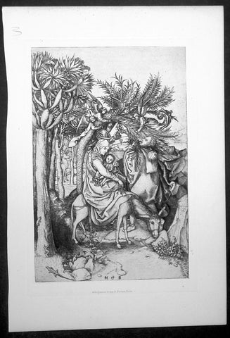
1870 Amand-Durand after Martin Schongauer Antique Print - Flight into Egypt
- Title : The Flight into Egypt
- Size: 13 1/2in x 9 1/2in (345mm x 240mm)
- Condition: (A+) Fine Condition
- Date : 1870
- Ref #: 22406
Description:
This fine, original antique wood-cut print an illustrating of the Flight out of Israel into Egypt by The Holy Family by Martin Schongauer - signed M†S - in 15th century was faithfully re-engraved and published by Charles Amand-Durand in 1870.
These beautiful re-engravings of classic and historical wood-cuts were painstakingly re-issued by Amand-Durand in Paris in the mid to late 19th century. Such is the quality of his re-strikes that Durands prints are now in major institutional collections such a the Louvre, National Gallery, The Met and many other famous Galleries. Please see below for further background on Amand-Durand.
General Definitions:
Paper thickness and quality: - Heavy and stable
Paper color : - off white
Age of map color: -
Colors used: -
General color appearance: -
Paper size: - 14in x 9 1/2in (350mm x 240mm)
Plate size: - 8in x 6in (205mm x 1530mm)
Margins: - Min 1in (25mm)
Imperfections:
Margins: - None
Plate area: - None
Verso: - None
Background:
Martin Schongauer 1445 - 1491 was one of the most prolific early engravers from the Rhine Valley. He signed all his prints with his initials, making him the first printmaker whose authorship was absolutely clear. While a handful of the artist’s paintings survive, Schongauer’s engravings inspired generations of artists, including Albrecht Dürer. This iconic image shows the Holy Family resting while fleeing the Massacre of the Innocents and their home in Israel for Egypt. The work reflects some traditional accounts of the story, in which angels lowered date palms for easy harvesting, so Mary, Joseph, and the Christ Child would not starve.
Schongauer was the most important printmaker north of the Alps before Albrecht Dürer.
The main work of Schongauer\'s life was the production of a large number of beautiful engravings, which were largely sold, not only in Germany, but also in Italy and even in England and Spain. Vasari says that Michelangelo copied one of his engravings, in the Trial of Saint Anthony. His style shows no trace of Italian influence, but a very clear and organised Gothic.
His subjects are mainly religious, but include comic scenes of ordinary life such as the Peasant family going to market or the Two apprentices fighting. One hundred and sixteen engravings are generally recognised as by his hand, and since several are only known from a single impression, there were probably others that are now lost. Many of his pupils\' plates as well as his own are signed, M†S, as are many copies probably by artists with no connection to him.
Among the most renowned of Schongauer\'s engravings are the series of the Passion and the Death and Coronation of the Virgin, and the series of the Wise and Foolish Virgins. All are remarkable for their miniature-like treatment, their brilliant touch, and their chromatic force. Some, such as the Death of the Virgin and the Adoration of the Magi are richly-filled compositions of many figures, treated with much largeness of style in spite of their minute scale.
He established the system of depicting volume by means of cross-hatching (lines in two directions) which was further developed by Dürer, and was the first engraver to curve parallel lines, probably by rotating the plate against a steady burin. He also developed a burin technique producing deeper lines on the plate, which meant that more impressions could be taken before the plate became worn.
According to Arthur Mayger Hind, Schongauer was one of the first German engravers to rise above the Gothic limitations both of setting and type and that he actualises an idea of beauty which in its nearer approach to more absolute ideals appeals to a far more universal appreciation than earlier engravers such as Master E. S.
The British Museum and other major print rooms possess fine collections of Schongauer\'s prints.

1870 Amand-Durand after Van Leyden Antique Print St George rescuing the Princess
- Title : Heliogravure et imp. A. Durand_Paris
- Size: 13 1/2in x 9 1/2in (345mm x 240mm)
- Condition: (A+) Fine Condition
- Date : 1870
- Ref #: 22443
Description:
This fine, original antique Heliograph of St. George Liberating the Princess by Lucas Van Leyden (1494 - 1533) in 1508 was re-engraved and published by Charles Amand-Durand in 1870.
These faithful re-engravings of classic and historical wood-cuts were faithfully re-issued by Amand-Durand in Paris in the mid to late 19th century. Such is the quality of his re-strikes that Durands prints are now in major institutional collections such a the Louvre, National Gallery, The Met and many other famous Galleries. Please see below for further background on Amand-Durand.
General Definitions:
Paper thickness and quality: - Heavy and stable
Paper color : - off white
Age of map color: -
Colors used: -
General color appearance: -
Paper size: - 13 1/2in x 9 1/2in (345mm x 240mm)
Plate size: - 8in x 6in (205mm x 1530mm)
Margins: - Min 1in (25mm)
Imperfections:
Margins: - None
Plate area: - None
Verso: - None
Background:
Lucas van Leyden (1494 – 1533), also named either Lucas Hugensz or Lucas Jacobsz, was a Dutch engraver and painter. He was among the first Dutch exponents of genre painting and is generally regarded as a very accomplished engraver.
Lucas was the son of Huygh Jacobsz. and was mainly active in Leiden.
Carel van Mander characterizes Lucas as a tireless artist, who as a child annoyed his mother by working long hours after nightfall, which she forbid not only for the cost of candlelight, but also because she felt that too much study was bad for his sensibilities. According to Van Mander, as a boy he only consorted with other young artists, such as painters, glass-etchers and goldsmiths, and was paid by the Heer van Lochorst (Johan van Lockhorst of Leiden, who died in 1510) a golden florin for each of his years at age 12 for a watercolor of St. Hubert.
From 1513 to 1517, Lucas created a series of woodcuts called The Power of Women which consisted of two large and small sets of prints. The series is one of a number of representations of the Power of Women theme, which was extremely popular in Renaissance art and literature. Artworks in the genre depict the traditional roles of men and women in inverse, with women dominating over men in various situations. The subjects illustrated often consist of legendary historical women who were considered to be virtuous heroines as well as women who were considered cunning, seductive, and manipulative of men. The purpose of the Power of Women theme was to demonstrate that even the strongest and wisest of men were not resistant to the sexuality of women.
The legend of Saint George and the Dragon describes the saint taming and slaying a dragon that demanded human sacrifices; the saint thereby rescues the princess chosen as the next offering.
1870 Amand-Durand after Van Leyden Antique Print The Annunciation to Virgin Mary
- Title : Heliogravure et imp A. Durand...Paris
- Date : 1870
- Condition: (A+) Fine Condition
- Ref: 22445
- Size: 14in x 9 1/2in (350mm x 240mm)
Description:
This fine, original antique Heliograph of The Annunciation, the Virgin Mary visited by the Angel Gabriel by Lucas Van Leyden (1494 - 1533) in 1508 was re-engraved and published by Charles Amand-Durand in 1870.
These faithful re-engravings of classic and historical wood-cuts were faithfully re-issued by Amand-Durand in Paris in the mid to late 19th century. Such is the quality of his re-strikes that Durands prints are now in major institutional collections such a the Louvre, National Gallery, The Met and many other famous Galleries. Please see below for further background on Amand-Durand.
General Definitions:
Paper thickness and quality: - Heavy and stable
Paper color : - off white
Age of map color: -
Colors used: -
General color appearance: -
Paper size: - 13 1/2in x 9 1/2in (345mm x 240mm)
Plate size: - 8in x 6in (205mm x 1530mm)
Margins: - Min 1in (25mm)
Imperfections:
Margins: - None
Plate area: - None
Verso: - None
Lucas van Leyden (1494 – 1533), also named either Lucas Hugensz or Lucas Jacobsz, was a Dutch engraver and painter. He was among the first Dutch exponents of genre painting and is generally regarded as a very accomplished engraver.
Lucas was the son of Huygh Jacobsz. and was mainly active in Leiden.
Carel van Mander characterizes Lucas as a tireless artist, who as a child annoyed his mother by working long hours after nightfall, which she forbid not only for the cost of candlelight, but also because she felt that too much study was bad for his sensibilities. According to Van Mander, as a boy he only consorted with other young artists, such as painters, glass-etchers and goldsmiths, and was paid by the Heer van Lochorst (Johan van Lockhorst of Leiden, who died in 1510) a golden florin for each of his years at age 12 for a watercolor of St. Hubert.
From 1513 to 1517, Lucas created a series of woodcuts called The Power of Women which consisted of two large and small sets of prints. The series is one of a number of representations of the Power of Women theme, which was extremely popular in Renaissance art and literature. Artworks in the genre depict the traditional roles of men and women in inverse, with women dominating over men in various situations. The subjects illustrated often consist of legendary historical women who were considered to be virtuous heroines as well as women who were considered cunning, seductive, and manipulative of men. The purpose of the Power of Women theme was to demonstrate that even the strongest and wisest of men were not resistant to the sexuality of women.
The Annunciation (from Latin annuntiatio), also referred to as The Annunciation to the Blessed Virgin Mary, the Annunciation of Our Lady, or the Annunciation of the Lord, is the Christian celebration of the announcement by the angel Gabriel to the Virgin Mary that she would conceive and become the mother of Jesus, the Son of God, marking his Incarnation. Gabriel told Mary to name her son Yeshua, meaning YHWH is salvation.
According to Luke 1:26, the Annunciation occurred in the sixth month of Elizabeth\'s pregnancy with John the Baptist. Many Christians observe this event with the Feast of the Annunciation on 25 March, an approximation of the northern vernal equinox nine full months before Christmas, the ceremonial birthday of Jesus. The Annunciation is a key topic in Christian art in general, as well as in Marian art in the Catholic Church, particularly during the Middle Ages and Renaissance. A work of art depicting the Annunciation is sometimes itself called an Annunciation.
1870 Augustin Mongin after Sir Peter Lely Antique Print of Princess Mary II as Diana
- Title : Mary II depicted as Diana
- Date : 1878
- Condition: (A+) Fine Condition
- Ref: 22399
- Size: 14in x 9 1/2in (350mm x 240mm)
Description:
This fine, original antique print of A Young Princess Mary II by the master etcher Augustin Mongin - signature engraved at the base of the print - after Sir Peter Lely was engraved and published in the 1878 edition of The Portfolio.
These faithful re-engravings of classic and historical wood-cuts were faithfully re-issued by in the mid to late 19th century. Such is the quality of his re-strikes these prints are now in major institutional collections such a the Louvre, National Gallery, The Met and many other famous Galleries. Please see below for further background.
General Description:
Paper thickness and quality: - Heavy & stable
Paper color: - Off white
Age of map color: -
Colors used: -
General color appearance: -
Paper size: - 14in x 9 1/2in (350mm x 240mm)
Margins: - Min 1in (25mm)
Imperfections:
Margins: - None
Plate area: - None
Verso: - None
Background:
Augustin Mongin:
A nineteenth century French painter and etcher, Augustin Mongin studied art in Paris under Gaucherel. He first exhibited at the Paris Salon in 1874 and during the following years received medals in 1876, 1885, 1887 and 1889. Augustin Mongin was elected to the Societe des Artistes Francais in 1887 and, in 1900, was awarded both the Chevalier de la Legion d'honneur and the medaille d'honneur. In his etchings, Augustin Mongin was best known for his for works after the art of old masters such as Karel du Jardin, Reynolds and Peter Lely. He was also commissioned by publishers in both France and England for etchings after contemporary artists, such as H. G. Glindoni.
Princess Mary is depicted as Diana, the goddess of hunting; in this guise she carries a bow, wears a crescent moon and is followed by a greyhound. Her rich silk gown recalls the dresses worn by the Windsor Beauties series in the Royal Collection painted by Lely. The landscape background reminds us of the work of Titian, whom the artist admired.
1870 Blackie & Son Antique Map The Western United States of America
- Title : The United States of North America Pacific States
- Ref #: 80560
- Size: 15in x 11in (380mm x 280mm)
- Date : 1870
- Condition: (A+) Fine Condition
Description:
This fine original antique lithograph map of the Western United States of America including Washington, Oregon, California, Arizona, Nevada, Idaho, Montana, Utah & part of Wyoming was engraved by Edward Weller andpublished by Blackie & Son of Glasgow in the1870 edition of the Geographical Atlas. (Ref: Tooley; M&B)
General Description:
Paper thickness and quality: - Heavy and stable
Paper colour: - off white
Age of map colour: - Original
Colours used: - Yellow, pink, green
General colour appearance: - Authentic
Paper size: - 15in x 11in (380mm x 280mm)
Margins: - min 1/2in (12mm)
Imperfections:
Margins: - None
Plate area: - None
Verso: - None
1870 Blackie & Son Large Antique Map of New Zealand w/ inset plan of Auckland
- Title : New Zealand
- Ref: 80571
- Size: 22in x 15in (560mm x 380mm)
- Date : 1870
- Condition: (A+) Fine Condition
Description:
This fine large, original antique map of New Zealand with an inset map of Auckland and its environs by John Bartholomew was published by Blackie & Son of Glasgow & London in the 1870 edition of the Geographical Atlas. (Ref: Tooley; M&B)
General Description:
Paper thickness and quality: - Heavy and stable
Paper colour: - off white
Age of map colour: - Original
Colours used: - Yellow, pink, green
General colour appearance: - Authentic
Paper size: - 22in x 15in (560mm x 380mm)
Margins: - min 1/2in (12mm)
Imperfections:
Margins: - None
Plate area: - None
Verso: - None
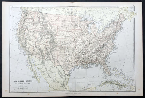
1870 Blackie & Son Large Antique Map of The United States of America
- Title : The United States of North America
- Ref #: 80558
- Size: 22in x 15in (560mm x 380mm)
- Date : 1870
- Condition: (A+) Fine Condition
Description:
This fine large original antique lithograph map of The United States of America was engraved by Edward Weller and published by Blackie & Son of Glasgow & London in the 1870 edition of the Geographical Atlas. (Ref: Tooley; M&B)
General Description:
Paper thickness and quality: - Heavy and stable
Paper colour: - off white
Age of map colour: - Original
Colours used: - Yellow, pink, green
General colour appearance: - Authentic
Paper size: - 22in x 15in (560mm x 380mm)
Margins: - min 1/4in (8mm)
Imperfections:
Margins: - None
Plate area: - None
Verso: - None
1870 Charles Amand-Durand after Johann Ladenspelder Antique Print #49 Tarot Card
- Title : Primo Mobile XXXXVIIII
- Date : 1870
- Condition: (A+) Fine Condition
- Ref: 22400
- Size: 13 1/2in x 9 1/2in (345mm x 240mm)
Description:
This fine, original antique Heliograph of card #49 of the Mantegna Tarocchi or Tarot Cards by the German engraver Johann Ladenspelder in the mid 16th century was re-engraved and published by Charles Amand-Durand in 1870.
These faithful re-engravings of classic and historical wood-cuts were faithfully re-issued by Amand-Durand in Paris in the mid to late 19th century. Such is the quality of his re-strikes that Durands prints are now in major institutional collections such a the Louvre, National Gallery, The Met and many other famous Galleries. Please see below for further background on Amand-Durand.
General Definitions:
Paper thickness and quality: - Heavy and stable
Paper color : - off white
Age of map color: -
Colors used: -
General color appearance: -
Paper size: - 13 1/2in x 9 1/2in (345mm x 240mm)
Plate size: - 8in x 6in (205mm x 1530mm)
Margins: - Min 1in (25mm)
Imperfections:
Margins: - None
Plate area: - None
Verso: - None
Background:
Johann (Hans) Ladenspelder 1512 - 1574 (aka Hans of Essen) was a german printmaker and engraver. He is particularly known for engraving a copy of a complete set (E series) of Mantegna Tarocchi cards, one of the earliest complete sets still extant.
1870 Charles Amand-Durand after Mattaus Zaisinger Antique Print - The Embrace
- Title : The Embrace
- Date : 1870
- Condition: (A+) Fine Condition
- Ref: 22403-1
- Size: 13 1/2in x 9 1/2in (345mm x 240mm)
Description:
This fine, original antique Heliograph of The Embrace by Master M Z or Mattaus Zaisinger in 1503 was re-engraved and published by Charles Amand-Durand in 1870.
These faithful re-engravings of classic and historical wood-cuts were faithfully re-issued by Amand-Durand in Paris in the mid to late 19th century. Such is the quality of his re-strikes that Durands prints are now in major institutional collections such a the Louvre, National Gallery, The Met and many other famous Galleries. Please see below for further background on Amand-Durand.
General Definitions:
Paper thickness and quality: - Heavy and stable
Paper color : - off white
Age of map color: -
Colors used: -
General color appearance: -
Paper size: - 13 1/2in x 9 1/2in (345mm x 240mm)
Plate size: - 8in x 6in (205mm x 1530mm)
Margins: - Min 1in (25mm)
Imperfections:
Margins: - None
Plate area: - None
Verso: - None
Matthaus Zaisinger (aka Master M.Z.), German (1498 - 1555) was a German Goldsmith & Engraver who published twenty-two engravings with the signature initials MZ. Six are dated (1500, 1501, 1503). There are no later dated prints and it is believed that most of his work is concentrated around c1500. The prints are equally divided between religious and secular subjects, often a state of disquiet inhabits his figures, accompanied by eccentric use of perspective and abrupt changes in scale, as seen for example in The Embrace and Solomons Idolatry. Most of his works have landscape backgrounds executed with a delicate, atmospheric touch that suggests a precursor of Albrecht Altdorfer and other painters of the Danube school.
<b>The Embrace</b> contains all of the elements of an adulterous tryst with the stag horns on the chandelier being a common symbol of cuckoldry, but the woman seems an unenthusiastic participant.
1870 Charles Murray after Bartolome Esteban Murillo Antique Print - Murillo Self Portrait
- Title : Bart Murillo seipsum depin gens. pro filorum votis acprecibus explendis
- Date : 1870
- Condition: (A+) Fine Condition
- Ref: 22446
- Size: 13 1/2in x 9 1/2in (350mm x 240mm)
Description:
This fine, original antique Heliograph self portrait of the Spanish artist Bartolome Esteban Murillo by the German engraver Heinrich Aldegrever or Aldegraf in the early 16th century was re-engraved and published by Charles Oliver Murray in 1870.
These faithful re-engravings of classic and historical wood-cuts were faithfully re-issued in the mid to late 19th century. Such is the quality of his re-strikes that many of these prints are now in major institutional collections such a the Louvre, National Gallery, The Met and many other famous Galleries. Please see below for further background.
The Latin inscription on the cartouche at the centre of the ledge explains that the self-portrait was made at the request of Murillo's children: 'Bart (olo) mé Murillo portraying himself to fulfil the wishes and prayers of his children - or sons'. Despite the unlined appearance of the face the painting is probably relatively late in date, of the early 1670s, when Murillo's children would have been of an age to take pride in their father's achievements. The composition is based on a formula that had been developed for portrait engravings used on the frontispiece of books. The sitter is shown in an oval frame and on the ledge below are the instruments of his profession, a palette and brushes on the right and a drawing and pencil on the left.
General Description:
Paper thickness and quality: - Heavy & stable
Paper color: - White
Age of map color: -
Colors used: - General color appearance: -
Paper size: - 13 1/2in x 9 1/2in (350mm x 240mm)
Margins: - Min 1/2in (12mm)
Imperfections:
Margins: - None
Plate area: - None
Verso: - None
Background:
Bartolomé Esteban Murillo (born late December 1617, died April 3, 1682) was a Spanish Baroque painter. Although he is best known for his religious works, Murillo also produced a considerable number of paintings of contemporary women and children. These lively, realist portraits of flower girls, street urchins, and beggars constitute an extensive and appealing record of the everyday life of his times.
Charles Oliver Murray (1842–1923) was a Scottish engraver. Born in Roxburghshire in 1842, Murray trained at the Trustees Academy in Edinburgh and moved to London by 1872. He was elected a Fellow of the Society of Painter-Etchers on 7 May 1881. He published widely in The Art Journal from the 1880s onwards and frequently exhibited at the Royal Academy. Murray died in London in 1923.(Ref: M&B; Tooley)
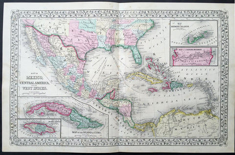
1870 Mitchell Large Antique Map of GOM, Texas, Mexico, Central America Caribbean
- Title : Map of Oceania exhibiting its various divisions Island group....1867 by S. Augustus Mitchell
- Date : 1870
- Condition: (A+) Fine Condition
- Ref: 35058
- Size: 22 1/2in x 14 1/2in (570mm x 370mm)
Description:
This large beautifully hand coloured original antique map of Texas, Mexico, Central America & the Caribbean - was published by Samuel Augustus Mitchell in the 1867 edition of his large New General Atlas - dated at the foot of the map. These county, state, city & country maps are some of the most ornate and beautifully coloured maps published in the US in the 19th century. For over 50 years, Mitchell his son's and their successors were the most prominent cartographical publishers of maps and atlases in the United States.
General Description:
Paper thickness and quality: - Heavy and stable
Paper color: - off white
Age of map color: - Original
Colors used: - Yellow, green, red, brown.
General color appearance: - Authentic and fresh
Paper size: - 22 1/2in x 14 1/2in (570mm x 370mm)
Plate size: - 22 1/2in x 14 1/2in (570mm x 370mm)
Margins: - Min ½in (12mm)
Imperfections:
Margins: - None
Plate area: - None
Verso: - None
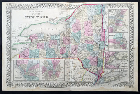
1870 Mitchell Large Antique Map of New York State
- Title : County Map of the State of New York...1870 S. Augustus Mitchell
- Ref #: 35024
- Size: 23in x 14 1/2in (580mm x 370mm)
- Date : 1870
- Condition: (A) Very Good Condition
Description:
This large two page beautifully hand coloured original antique map of New York State - with inset maps of West Troy, Alabany, New York Harbor, Buffalo & Rochester - was published by Samuel Augustus Mitchell in the 1870 edition of his large New General Atlas - dated at the foot of the map.
These county, state, city & country maps are some of the most ornate and beautifully coloured maps published in the US in the 19th century. For over 50 years, Mitchell his son's and their successors were the most prominent cartographical publishers of maps and atlases in the United States.
General Description:
Paper thickness and quality: - Heavy and stable
Paper color: - off white
Age of map color: - Original
Colors used: - Yellow, green, red, brown.
General color appearance: - Authentic and fresh
Paper size: - 23in x 14 1/2in (580mm x 370mm)
Plate size: - 23in x 14 1/2in (580mm x 370mm)
Margins: - Min ½in (12mm)
Imperfections:
Margins: - Light soiling in bottom margin
Plate area: - Light age toning
Verso: - None
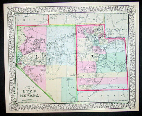
1870 S Augustus Mitchell Antique County Map of Utah and Nevada
- Title : County Map of Utah and Nevada....1870 by S. Augustus Mitchell
- Ref #: 35052
- Size: 15in x 12in (380mm x 300mm)
- Date : 1870
- Condition: (A+) Fine Condition
Description:
This beautifully hand coloured original antique map was published by Samuel Augustus Mitchell in the 1870 edition of his large New General Atlas - dated at the foot of the map.
These county, state, city & country maps are some of the most ornate and beautifully coloured maps published in the US in the 19th century. For over 50 years, Mitchell his son's and their successors were the most prominent cartographical publishers of maps and atlases in the United States.
General Description:
Paper thickness and quality: - Heavy & stable
Paper color: - White
Age of map color: - Original
Colors used: - Green, pink, yellow
General color appearance: - Authentic
Paper size: - 15in x 12in (380mm x 300mm)
Plate size: - 15in x 12in (380mm x 300mm)
Margins: - Min 1/2in (10mm)
Imperfections:
Margins: - None
Plate area: - None
Verso: - None
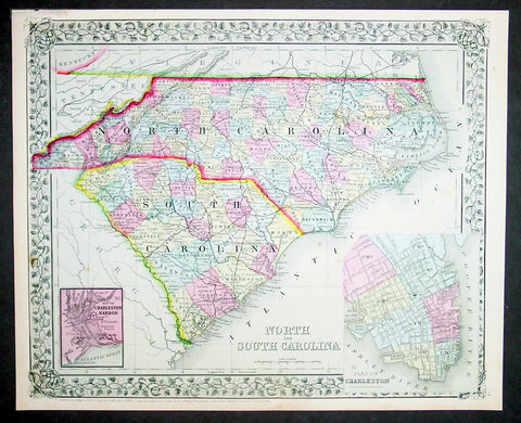
1870 S Augustus Mitchell Antique Map North & South Carolina
- Title : County Map of North and South Carolina....1870 by S. Augustus Mitchell
- Ref #: 35039
- Size: 15in x 12in (380mm x 300mm)
- Date : 1870
- Condition: (A+) Fine Condition
Description:
This beautifully hand coloured original antique map was published by Samuel Augustus Mitchell in the 1870 edition of his large New General Atlas - dated at the foot of the map.
These county, state, city & country maps are some of the most ornate and beautifully coloured maps published in the US in the 19th century. For over 50 years, Mitchell his son's and their successors were the most prominent cartographical publishers of maps and atlases in the United States.
General Description:
Paper thickness and quality: - Heavy & stable
Paper color: - White
Age of map color: - Original
Colors used: - Green, pink, yellow
General color appearance: - Authentic
Paper size: - 15in x 12in (380mm x 300mm)
Plate size: - 15in x 12in (380mm x 300mm)
Margins: - Min 1/2in (10mm)
Imperfections:
Margins: - None
Plate area: - None
Verso: - None
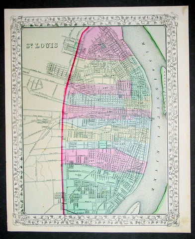
1870 S Augustus Mitchell Antique Map Plan City of St Louis, Missouri
- Title : St Louis....1870 by S. Augustus Mitchell
- Ref #: 35048
- Size: 15in x 12in (380mm x 300mm)
- Date : 1870
- Condition: (A+) Fine Condition
Description:
This beautifully hand coloured original antique city plan map was published by Samuel Augustus Mitchell in the 1870 edition of his large New General Atlas - dated at the foot of the map.
These county, state, city & country maps are some of the most ornate and beautifully coloured maps published in the US in the 19th century. For over 50 years, Mitchell his son's and their successors were the most prominent cartographical publishers of maps and atlases in the United States.
General Description:
Paper thickness and quality: - Heavy & stable
Paper color: - White
Age of map color: - Original
Colors used: - Green, pink, yellow
General color appearance: - Authentic
Paper size: - 15in x 12in (380mm x 300mm)
Plate size: - 15in x 12in (380mm x 300mm)
Margins: - Min 1/2in (10mm)
Imperfections:
Margins: - None
Plate area: - None
Verso: - None
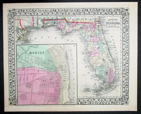
1870 Samuel Augustus Mitchell Antique County Map of Florida
- Title : County Map of Florida, Mobile....1870 by S. Augustus Mitchell
- Ref #: 35040
- Size: 15in x 12in (380mm x 300mm)
- Date : 1870
- Condition: (A+) Fine Condition
Description:
This beautifully hand coloured original antique map was published by Samuel Augustus Mitchell in the 1870 edition of his large New General Atlas - dated at the foot of the map.
These county, state, city & country maps are some of the most ornate and beautifully coloured maps published in the US in the 19th century. For over 50 years, Mitchell his son's and their successors were the most prominent cartographical publishers of maps and atlases in the United States.
General Description:
Paper thickness and quality: - Heavy & stable
Paper color: - White
Age of map color: - Original
Colors used: - Green, pink, yellow
General color appearance: - Authentic
Paper size: - 15in x 12in (380mm x 300mm)
Plate size: - 15in x 12in (380mm x 300mm)
Margins: - Min 1/2in (10mm)
Imperfections:
Margins: - None
Plate area: - None
Verso: - None

1870 Samuel Augustus Mitchell Antique County Map of Iowa and Missouri
- Title : County Map of the States of Iowa and Missouri....1870 by S. Augustus Mitchell
- Ref #: 35047
- Size: 15in x 12in (380mm x 300mm)
- Date : 1870
- Condition: (A+) Fine Condition
Description:
This beautifully hand coloured original antique map was published by Samuel Augustus Mitchell in the 1870 edition of his large New General Atlas - dated at the foot of the map.
These county, state, city & country maps are some of the most ornate and beautifully coloured maps published in the US in the 19th century. For over 50 years, Mitchell his son's and their successors were the most prominent cartographical publishers of maps and atlases in the United States.
General Description:
Paper thickness and quality: - Heavy & stable
Paper color: - White
Age of map color: - Original
Colors used: - Green, pink, yellow
General color appearance: - Authentic
Paper size: - 15in x 12in (380mm x 300mm)
Plate size: - 15in x 12in (380mm x 300mm)
Margins: - Min 1/2in (10mm)
Imperfections:
Margins: - None
Plate area: - None
Verso: - None
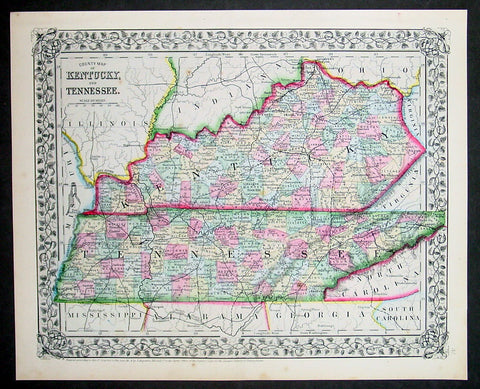
1870 Samuel Augustus Mitchell Antique County Map of Kentucky and Tennessee
- Title : County Map of Kentucky and Tennessee....1870 by S. Augustus Mitchell
- Ref #: 35037
- Size: 15in x 12in (380mm x 300mm)
- Date : 1870
- Condition: (A+) Fine Condition
Description:
This beautifully hand coloured original antique map was published by Samuel Augustus Mitchell in the 1870 edition of his large New General Atlas - dated at the foot of the map.
These county, state, city & country maps are some of the most ornate and beautifully coloured maps published in the US in the 19th century. For over 50 years, Mitchell his son's and their successors were the most prominent cartographical publishers of maps and atlases in the United States.
General Description:
Paper thickness and quality: - Heavy & stable
Paper color: - White
Age of map color: - Original
Colors used: - Green, pink, yellow
General color appearance: - Authentic
Paper size: - 15in x 12in (380mm x 300mm)
Plate size: - 15in x 12in (380mm x 300mm)
Margins: - Min 1/2in (10mm)
Imperfections:
Margins: - None
Plate area: - None
Verso: - None
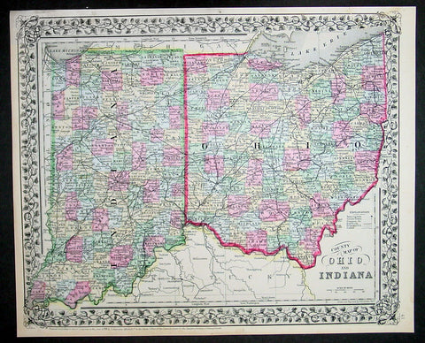
1870 Samuel Augustus Mitchell Antique County Map of Ohio and Indiana
- Title : County Map of Ohio and Indiana....1870 by S. Augustus Mitchell
- Ref #: 35043
- Size: 15in x 12in (380mm x 300mm)
- Date : 1870
- Condition: (A+) Fine Condition
Description:
This beautifully hand coloured original antique map was published by Samuel Augustus Mitchell in the 1870 edition of his large New General Atlas - dated at the foot of the map.
These county, state, city & country maps are some of the most ornate and beautifully coloured maps published in the US in the 19th century. For over 50 years, Mitchell his son's and their successors were the most prominent cartographical publishers of maps and atlases in the United States.
General Description:
Paper thickness and quality: - Heavy & stable
Paper color: - White
Age of map color: - Original
Colors used: - Green, pink, yellow
General color appearance: - Authentic
Paper size: - 15in x 12in (380mm x 300mm)
Plate size: - 15in x 12in (380mm x 300mm)
Margins: - Min 1/2in (10mm)
Imperfections:
Margins: - None
Plate area: - None
Verso: - None
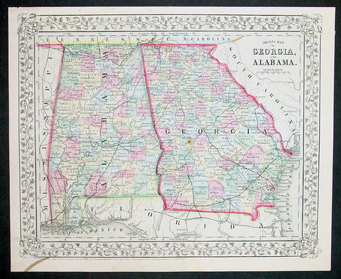
1870 Samuel Augustus Mitchell County Antique Map of Georgia and Alabama
- Title : County Map of Georgia and Alabama....1870 by S. Augustus Mitchell
- Ref #: 35038
- Size: 15in x 12in (380mm x 300mm)
- Date : 1870
- Condition: (A+) Fine Condition
Description:
This beautifully hand coloured original antique map was published by Samuel Augustus Mitchell in the 1870 edition of his large New General Atlas - dated at the foot of the map.
These county, state, city & country maps are some of the most ornate and beautifully coloured maps published in the US in the 19th century. For over 50 years, Mitchell his son's and their successors were the most prominent cartographical publishers of maps and atlases in the United States.
General Description:
Paper thickness and quality: - Heavy & stable
Paper color: - White
Age of map color: - Original
Colors used: - Green, pink, yellow
General color appearance: - Authentic
Paper size: - 15in x 12in (380mm x 300mm)
Plate size: - 15in x 12in (380mm x 300mm)
Margins: - Min 1/2in (10mm)
Imperfections:
Margins: - None
Plate area: - None
Verso: - None
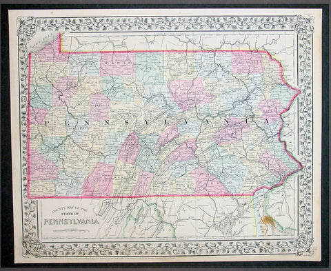
1870 Samuel Augustus Mitchell County Antique Map of the State of Pennsylvania
- Title : County Map of Florida, Mobile....1870 by S. Augustus Mitchell
- Ref #: 35051
- Size: 15in x 12in (380mm x 300mm)
- Date : 1870
- Condition: (A+) Fine Condition
Description:
This beautifully hand coloured original antique map was published by Samuel Augustus Mitchell in the 1870 edition of his large New General Atlas - dated at the foot of the map.
These county, state, city & country maps are some of the most ornate and beautifully coloured maps published in the US in the 19th century. For over 50 years, Mitchell his son's and their successors were the most prominent cartographical publishers of maps and atlases in the United States.
General Description:
Paper thickness and quality: - Heavy & stable
Paper color: - White
Age of map color: - Original
Colors used: - Green, pink, yellow
General color appearance: - Authentic
Paper size: - 15in x 12in (380mm x 300mm)
Plate size: - 15in x 12in (380mm x 300mm)
Margins: - Min 1/2in (10mm)
Imperfections:
Margins: - None
Plate area: - None
Verso: - None

1870 Samuel Augustus Mitchell County Antique Map of Virginia & West Virginia
- Title : County Map of Virginia and West Virginia....1870 by S. Augustus Mitchell
- Ref #: 35036
- Size: 15in x 12in (380mm x 300mm)
- Date : 1870
- Condition: (A+) Fine Condition
Description:
This beautifully hand coloured original antique map was published by Samuel Augustus Mitchell in the 1870 edition of his large New General Atlas - dated at the foot of the map.
These county, state, city & country maps are some of the most ornate and beautifully coloured maps published in the US in the 19th century. For over 50 years, Mitchell his son's and their successors were the most prominent cartographical publishers of maps and atlases in the United States.
General Description:
Paper thickness and quality: - Heavy & stable
Paper color: - White
Age of map color: - Original
Colors used: - Green, pink, yellow
General color appearance: - Authentic
Paper size: - 15in x 12in (380mm x 300mm)
Plate size: - 15in x 12in (380mm x 300mm)
Margins: - Min 1/2in (10mm)
Imperfections:
Margins: - None
Plate area: - None
Verso: - None
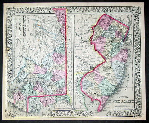
1870 Samuel Augustus Mitchell County Antique Maps New Jersey, Maryland, Delaware
- Title : County Map of New Jersey; County Map of Maryland and Delaware....1870 by S. Augustus Mitchell
- Ref #: 35033
- Size: 15in x 12in (380mm x 300mm)
- Date : 1870
- Condition: (A+) Fine Condition
Description:
This beautifully hand coloured original antique map was published by Samuel Augustus Mitchell in the 1870 edition of his large New General Atlas - dated at the foot of the map.
These county, state, city & country maps are some of the most ornate and beautifully coloured maps published in the US in the 19th century. For over 50 years, Mitchell his son's and their successors were the most prominent cartographical publishers of maps and atlases in the United States.
General Description:
Paper thickness and quality: - Heavy & stable
Paper color: - White
Age of map color: - Original
Colors used: - Green, pink, yellow
General color appearance: - Authentic
Paper size: - 15in x 12in (380mm x 300mm)
Plate size: - 15in x 12in (380mm x 300mm)
Margins: - Min 1/2in (10mm)
Imperfections:
Margins: - None
Plate area: - None
Verso: - None