Products

1597 Cornelis Wytfliet Antique Map Early Important Map of Australia, South America Terra Australis
- Title : Chica Sive Patagonica et Australis Terra
- Size: 15in x 12in (380mm x 305mm)
- Condition: (A+) Fine Condition
- Date : 1597
- Ref #: 41718
Description:
A fine original antique, and incredibly important map of Patagonia & the Magellan Straits but more importantly one of the first maps to depict a distinctive outline of Australia - depicted here as part of Terra Australis the Great Southern Land - and was published by Cornelis van Wytfliet in the 1597 edition of Descriptionis Ptolemaicae Augmentum.
Wytfliets famous map of the southern continent from the first atlas of the Americas, Descriptionis Ptolemaicae Augmentum, sive Occidentis Notitia in 1597.
In the top part of the map, Patagonia is separated by a strait from a large southern continent named Australis Terrae Pars. The naming of C. Della Victoria and the illustration of Magellans ship, Victoria, indicates, although not names on the map, as the Strait of Magellan. The lower portion of the map is a polar projection, showing Terra Australis as the large landmass made up of four peninsulas, one reaching towards New Guinea which is shown as an island. This and the other peninsula to the west is one of the earliest and clearest indications of cartographical knowledge of Northern Australia, specifically Northern Queensland, the Gulf of Carpentaria & parts of the Northern Territory.
Gunter Schilder discusses this map at length and points to its significance to Major Collingridge and others as proof that Australia had already been discovered in the sixteenth century....
Wytfliet notes The Australis Terra is the most southern of all lands; it is separated from New Guinea by a narrow strait; its shores are hitherto but little known, since, after one voyage and another, that route has been deserted, and seldom is the country visited unless when sailors are driven there by storms. The Australis Terra begins at two or three degrees from the equator, and is maintained by some to be of so great an extent that if it were thoroughly explored it would be regarded as a fifth part of the world.
Wyfliets depiction of a narrow strait separating Australis Terra from New Guinea, predates that of Torress discovery in 1606. Torress passage was not known to the world until the end of the 18th century, when Dalrymple discovered Torress journal of the voyage amongst archives in Manila.
General Definitions:
Paper thickness and quality: - Heavy and stable
Paper color : - off white
Age of map color: -
Colors used: -
General color appearance: -
Paper size: - 15in x 12in (380mm x 305mm)
Plate size: - 11 1/4in x 9 1/4in (285mm x 235mm)
Margins: - Min 1in (25mm)
Imperfections:
Margins: - None
Plate area: - None
Verso: - None
Background:
In 1597 Cornelis van Wytfliet published his Augmentum to Ptolemys Geography. Dedicated to Philip III of Spain it is a history of the New World to date, recording its discovery, natural history etc. For the book Wytfliet had engraved nineteen maps, by whom we do not know, one of the world and eighteen regional maps of the Americas. As such this book can be truly called the first atlas of the New World, America.
Wytfliet, Cornelis van d. 1597
Cornelius Wytfliet or Cornelis van Wytfliet was a geographer from Leuven in the Habsburg Netherlands, best known for producing the first atlas of the Americas.
Cornelius was the son of Catherine Huybrechts and her husband, Gregorius Wytfliet, who was advocate fiscal of Leuven University from 1557 to 1594. After graduating Licentiate in Laws from the University of Leuven, Wytfliet moved to Brussels and became secretary to the Council of Brabant. He died in or shortly after 1597, when his Descriptionis Ptolemaicae Augmentum (a work adding new discoveries to Ptolemy\\\'s description of the world) was published
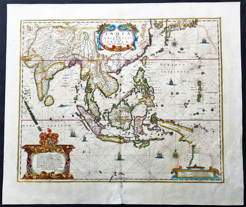
1639 Hondius Antique Map of Australia, East Indies, India to China - Duyfken
- Title : India quae Orientalis dicitur et Insulae Adiacentes
- Date : 1639
- Condition: (A+) Fine Condition
- Ref: 43140
- Size: 22 1/2in x 19 1/4in (570mm x 485mm)
Description:
This fine beautifully hand coloured original antique and very important map of the East Indies, India, SE Asia, China, Japan Philippines and Australia - the first to map the west coast of Cape York Peninsular northern Queensland as well as parts of the SW coast of Western Australia, with place names, was published in the 1639 French edition of Mercators Atlas by Jan Jansson and Henricus Hondius.
An important Dutch map of South East Asia, noteworthy for including the discoveries made in New Guinea and northern Queensland, Australia by the Dutch vessel Duyfken in 1605-06. Under the command of Willem Janzoon, the Duyfken explored the eastern shore of the Gulf of Carpentaria, just below the Cape York Peninsula, a venture which was famously the first recorded European contact with Australia.
Condition Report
Paper thickness and quality: - Heavy and stable
Paper color: - off white
Age of map color: - Original
Colors used: - Red, yellow, green
General color appearance: - Authentic
Paper size: - 22 1/2in x 19 1/4in (570mm x 485mm)
Plate size: - 19 1/4in x 15 1/2in (485mm x 395mm)
Margins: - Min 1in (25mm)
Imperfections:
Margins: - Light age toning
Plate area: - Light offsetting, light age toning
Verso: - Light age toning
Background:
This map of the East Indies extending from India to Japan and south to Australia, shows some of the Dutch discoveries along the West Australian coastline like the Swan River, Nassau River, Coen River and the Batavia River borrows heavily from the exact map by Joan Blaeu. On the eastern part lower right of the map is a small section of Cape York Peninsular. This map is one of the first printed maps to show any part of the Australian coastline. It continued to be an issued unchanged from 1635 up until the 1660's, long after some of the information it contained had been superseded. This was despite the fact that Joan Blaeu as cartographer to the Dutch East India Company from 1638 to 1673 had access to the latest information concerning the extension of the Dutch maritime power in the East Indies, publishing the results of such discoveries (especially of Australia) on large World maps, such as that of 1648. In other words, atlas map's of the East Indies and part of Australia ignores the results of Abel Tasman's discoveries made during the voyage of 1642-44. In 1642, Tasman was appointed commander of an expedition to the South Seas, during which he discovered the Island later named after him as well as part of the coast of New Zealand. His voyage 1644 coasted along the shore of the Gulf of Carpentaria and along the northern coast of Australia as far as the Tropic of Capricorn.
Tasman's discoveries were published very soon afterwards on Blaeu's large World Maps, rendering it all the more curious that the atlas map was never revised. In affect, this map remained an historical map of the archipelago, showing discoveries made. albeit in a rather haphazard and fortuitous manner by the Dutch, between 1606 and 1623.. The design of the map emphasises the importance of the commercial interests in the East Indies, centred as it is on the heart of what was to become The Netherlands East Indies and later Indonesia. (Ref: Koeman; M&B)

1639 Jan Jansson Antique Map of East Indies, Australia - Voyage of Dufken, Spice Islands
- Title : Indiae Orientalis Nova Descriptio
- Ref #: 43144
- Size: 22 1/2in x 19in (570mm x 485mm)
- Date : 1639
- Condition: (A) Very Good Condition
Description:
This beautiful, very significant original antique map of SE Asia, the East Indies PNG and significantly a small portion of the west coast of Australia's Cape York Peninsular was published in the 1639 French edition of Mercator's Atlas published by Henricus Hondius and Jan Jansson.
Condition Report:
Paper thickness and quality: - Heavy and stable
Paper color: - off white
Age of map color: - Later
Colors used: - Yellow, pink, green
General color appearance: - Authentic
Paper size: - 22 1/2in x 19in (570mm x 485mm)
Plate size: - 20in x 15 1/2in (510mm x 395mm)
Margins: - Min 1in (25mm)
Imperfections:
Margins: - Uniform age toning, bottom centerfold restored
Plate area: - Uniform age toning, centerfold re-joined
Verso: - Uniform age toning
Background: This landmark map is the first published record of the discoveries made by the Dutch ship Dufken on route to Cape York in Australia. New Guinea ("Landt vande Papuos") is marked the (Is)land next to it is called ÔNieu ZeelandtÕ and the island Duyfkens is named after the ship Duyfken.
With the first publication of this map 27 years had passed since the voyage of the Dufken and its discoveries of PNG and NW Australia had been completed. The Dutch East India Company had suppressed the discoveries until it was sure how profitable or not Australia would be.
Jansson & Hondius were the first to published this map in 1630 and it is believed the information was leaked from the Blaeu firm - the official cartographers to the Dutch East India Company. Surprisingly Blaeu did not publish a similar map for another two years. It must have been incredibly galling for Blaeu to have known of the discoveries for nearly thirty years and then to have been beaten to publication by his fiercest rival Jansson & Hondius.
Given this information this is an incredibly significant map of this imporatant region being the first map published with concrete first hand knowledge of the area which prior had been mapped based mainly on speculation or second hand knowledge.
The text running for two pages on the back of the map generally describes the region or country name, history (as it was), temperature, seasons, soil and agricultural productivity. Also described is the topography, wildlife, local inhabitants their culture and religion, as well as a description of major European and local towns and cities. This text makes extremely enjoyable reading and a very good insight not only into the area described but the general European attitudes towards alien countries and cultures. (Ref: Suraz; Koeman; M&B; Tooley)
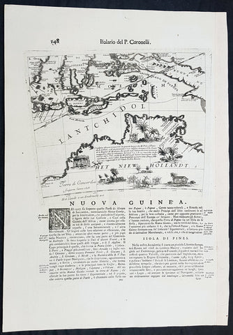
1692 Vincenzo Coronelli Antique Globe Gore Rare Map of Australia, Indonesia
- Title : Nuova Guinea
- Size: 19 1/2in x 14in (495mm x 360mm)
- Condition: (A+) Fine Condition
- Date : 1692
- Ref #: 30783
Description:
This finely engraved original antique map, a scarce Globe Gore map section - from Vincenzo Coronellis original 42in Globe of Australia, New Guinea and parts of the Islands of Indonesia - one of the earliest detailed maps of Australia - was published by Vincenzo Maria Coronelli in the 1696 Venice edition of Isolario dell Atlante Veneto.
To my mind Coronellis maps are some of the most beautifully engraved maps of the 17th century and the epitome of these are his Globe Gores.
In 1696 Coronelli published all his globe gores - from the 2in to the 42 in Globes - in an atlas, Libero dei Globi, part of the great series of atlases, Isolario dell Atlante Veneto that was published by Coronelli to ensure his work was available to a wider audience, as very few could afford travel to Venice, Rome or Paris to view his completed globes.
General Definitions:
Paper thickness and quality: - Heavy and stable
Paper color : - off white
Age of map color: -
Colors used: -
General color appearance: -
Paper size: - 19 1/2in x 14in (495mm x 360mm)
Plate size: - 11 1/2in x 9 1/2in (280mm x 235mm)
Margins: - Min 1in (25mm)
Imperfections:
Margins: - None
Plate area: - None
Verso: - None
Background:
The original globe gores for the 42in Terrestrial & Celestial Globe were printed on 12 full length sheets - with two polar calottes - in 1688.
To help fit into Coronellis future publications of Atlante Veneto, Libro dei Globi and Isolario dell Atlante Veneto the gore sheets were re-issued as the same size but cut into smaller sections. This effectively allowed the gores to be published in their original size but instead of one sheet per gore there were 2, 4 or 6 sheets making up the one gore.
The first edition of Coronellis 3 ½-foot celestial globe was engraved by Nolin in Paris after drawings provided by the Italian geographer and was printed in 1688. At the same time, its terrestrial counterpart was engraved and printed in Venice under Coronellis direction. These globes were produced in part as replicas of the gigantic and unique 15 foot-diameter pair of globes that Coronelli constructed and presented to Louis XIV, the King of France, in 1683, and which secured his fame as Europes premier globe maker. In 1693, soon after Coronelli engraved and printed the first Venetian edition of the 3 ½-foot celestial globe, Nolin engraved at Paris an entirely new edition on new plates. This globe was based on Coronellis work, but with the main legends in Latin, not Italian, as befitted a French market. The 3 ½ foot celestial globe was one of the crowning glories of Coronellis output and was also the grandest celestial globe of the 17th century.
(Ref: Shirley; Armao, Ermanno. Vincenzo Coronelli Cenni sulluomo e la sua Vita Catalogo... Bibliopolis, Florence pp.130-134)
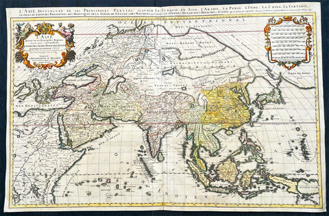
1696 Alexis Hubert Jaillot Large Antique Map of Asia - Saudi Arabia to Australia
- Title : L' Asie divisee en ses Principales Regions....Hubert Jaillot....1696
- Ref #: 17022
- Size: 35 1/2in x 23in (900mm x 585mm)
- Date : 1696
- Condition: (A) Very Good Condition
Description:
This very large original hand coloured antique map of Asia, from Arabia to the Gulf of Carpentaria, Australia, was engraved in 1696 - dated in title - and was published by Alexis Hubert Jaillot in his monumental Atlas Nouveau.
General Definitions:
Paper thickness and quality: - Heavy and stable
Paper color : - off white
Age of map color: - Original
Colors used: - Yellow, green, blue, pink
General color appearance: - Authentic
Paper size: - 35 1/2in x 23in (900mm x 585mm)
Plate size: - 34 1/2in x 22 1/2in (875mm x 570mm)
Margins: - Min 1/2in (15mm)
Imperfections:
Margins: - Light age toning in margin
Plate area: - Re-enforced along centerfold, light age toning, old ink text to bottom of map
Verso: - Soiling
Background:
The map include lines of latitude and longitude, some topographical details, location of settlements, rivers, and lakes (including the lakes Parime, thought to be where the fabulous El Dorado was located) as well as the boundaries of the possessions of the European claimants to South America.
Extremely decorative cartouche with dedication to Le Dauphin, and his coat of arms in top.
After Nicolas Sanson, Hubert Jaillot and Pierre Duval were the most important French cartographers of the seventeenth & eighteenth centuries. Jaillot, originally a sculptor, became interested in geography after his marriage to the daughter of Nicolas Berey (1606-65), a famous map colourist, and went into partnership in Paris with Sanson's sons. There, from about 1669, he undertook the re-engraving, enlarging and re-publishing of the Sanson maps in sheet form and in atlases, sparing no effort to fill the gap in the map trade left by the destruction of Blaeu's printing establishment in Amsterdam in 1672. Many of his maps were printed in Amsterdam (by Pierre Mortier) as well as in Paris. One of his most important works was a magnificent sea atlas, Le Neptune François, published in 1693 and compiled in co-operation with J D Cassini. This was re-published shortly afterwards by Pierre Mortier in Amsterdam with French, Dutch and English texts, the charts having been re-engraved. Eventually, after half a century, most of the plates were used again as the basis for a revised issue published by J N Bellin in 1753.(Ref: Tooley; M&B)
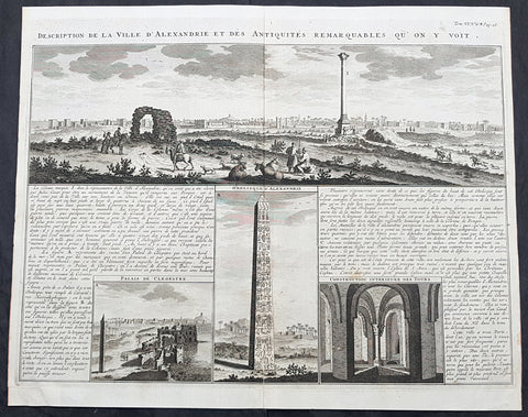
1719 Abraham Chatelain Large Antique Map Panoramic View of Alexandria, Egypt
- Title : Description de la Ville D Alexandrie des Antquites Remarquables Qu on Y Voit
- Size: 20in x 16in (515mm x 405mm)
- Condition: (A+) Fine Condition
- Date : 1719
- Ref #: 50649
Description:
This large original copper plate engraved antique print a view of the city of Alexandria, Egypt and the surrounding ancient ruins was published by Henri Abraham Chatelain in 1719, in his famous Atlas Historique.
General Definitions:
Paper thickness and quality: - Heavy and stable
Paper color : - off white
Age of map color: -
Colors used: -
General color appearance: -
Paper size: - 20in x 16in (515mm x 405mm)
Plate size: - 19in x 15in (485mm x 380mm)
Margins: - Min 1/2in (12mm)
Imperfections:
Margins: - None
Plate area: - None
Verso: - None
Background:
Alexandria is the second-largest city in Egypt and a major economic centre, extending about 32 km (20 mi) along the coast of the Mediterranean Sea in the north central part of the country. Its low elevation on the Nile delta makes it highly vulnerable to rising sea levels. Alexandria is an important industrial center because of its natural gas and oil pipelines from Suez. Alexandria is also a popular tourist destination.
Alexandria was founded around a small, ancient Egyptian town c. 332 BC by Alexander the Great, king of Macedon and leader of the Greek League of Corinth, during his conquest of the Achaemenid Empire. Alexandria became an important center of Hellenistic civilization and remained the capital of Ptolemaic Egypt and Roman and Byzantine Egypt for almost 1,000 years, until the Muslim conquest of Egypt in AD 641, when a new capital was founded at Fustat (later absorbed into Cairo). Hellenistic Alexandria was best known for the Lighthouse of Alexandria (Pharos), one of the Seven Wonders of the Ancient World; its Great Library (the largest in the ancient world); and the Necropolis, one of the Seven Wonders of the Middle Ages. Alexandria was at one time the second most powerful city of the ancient Mediterranean region, after Rome. Ongoing maritime archaeology in the harbor of Alexandria, which began in 1994, is revealing details of Alexandria both before the arrival of Alexander, when a city named Rhacotis existed there, and during the Ptolemaic dynasty.
Alexandria figured prominently in the military operations of Napoleons expedition to Egypt in 1798. French troops stormed the city on 2 July 1798, and it remained in their hands until the arrival of a British expedition in 1801. The British won a considerable victory over the French at the Battle of Alexandria on 21 March 1801, following which they besieged the city, which fell to them on 2 September 1801. Muhammad Ali, the Ottoman governor of Egypt, began rebuilding and redevelopment around 1810, and by 1850, Alexandria had returned to something akin to its former glory.
From the late 18th century, Alexandria became a major center of the international shipping industry and one of the most important trading centers in the world, both because it profited from the easy overland connection between the Mediterranean Sea and the Red Sea, and the lucrative trade in Egyptian cotton.

1719 Chatelain Antique Map of Panama, Flora & Fauna of Australia by William Dampier
- Title : Description de l Isthme de Darien Des Proprietez du Pais et de la Ville de Panama a la quelle on a joint une description curieuse des diverses plantes, oiseaux, poissons les plus rares qui se trouvent dans la Nouvelle Hollande
- Size: 20in x 17 1/2in (510mm x 440mm)
- Condition: (A+) Fine Condition
- Date : 1719
- Ref #: 50633
Description:
This large original copper-plate engraved antique map of Panama & Central America plus plants, animals and birds from Brazil, South America and Australia, as visited by William Dampier (1651 - 1715) in 1688, was published by Henri Abraham Chatelain in 1719, in his famous Atlas Historique.
These are truly some of the best early engravings of this region done at the time that were copied by the likes of Prevost, Harrison & others in the 18th century, but not with the same eye for detail.
General Definitions:
Paper thickness and quality: - Heavy and stable
Paper color : - off white
Age of map color: -
Colors used: -
General color appearance: -
Paper size: - 20in x 17 1/2in (510mm x 440mm)
Plate size: - 17 1/2in x 15in (440mm x 380mm)
Margins: - Min 1in (25mm)
Imperfections:
Margins: - None
Plate area: - None
Verso: - None
Background:
In 1679, William Dampier joined the crew of the buccaneer Captain Bartholomew Sharp on the Spanish Main of Central America, twice visiting the Bay of Campeche, or Campeachy as it was then known, on the north coast of Mexico. This led to his first circumnavigation, during which he accompanied a raid across the Isthmus of Darién in Panama and took part in the capture of Spanish ships on the Pacific coast of that isthmus. The pirates then raided Spanish settlements in Peru before returning to the Caribbean.
Dampier made his way to Virginia, where in 1683 he was engaged by the privateer John Cooke. Cooke entered the Pacific via Cape Horn and spent a year raiding Spanish possessions in Peru, the Galápagos Islands, and Mexico. This expedition collected buccaneers and ships as it went along, at one time having a fleet of ten vessels. Cooke died in Mexico, and a new leader, Edward Davis, was elected captain by the crew.
Dampier transferred to the privateer Charles Swans ship, Cygnet, and on 31 March 1686 they set out across the Pacific to raid the East Indies, calling at Guam and Mindanao. Spanish witnesses saw the predominantly English crew as not only pirates and heretics but also cannibals. Leaving Swan and 36 others behind on Mindanao, the rest of the privateers sailed on to Manila, Poulo Condor, China, the Spice Islands, and New Holland. Contrary to Dampiers later claim that he had not actively participated in actual piratical attacks during this voyage, he was in fact selected in 1687 to command one of the Spanish ships captured by Cygnets crew off Manila.
On 5 January 1688, Cygnet anchored two miles from shore in 29 fathoms on the northwest coast of Australia, near King Sound. Dampier and his ship remained there until March 12, and while the ship was being careened Dampier made notes on the fauna and flora and the indigenous peoples he found there. Among his fellows were a significant number of Spanish sailors, most notably Alonso Ramírez, a native of San Juan, Puerto Rico Later that year, by agreement, Dampier and two shipmates were marooned on one of the Nicobar Islands. They obtained a small canoe which they modified after first capsizing and then, after surviving a great storm at sea, called at Acheen (Aceh) in Sumatra.
Dampier returned to England in 1691 via the Cape of Good Hope, penniless but in possession of his journals. He also had as a source of income a slave known as Prince Jeoly (or Giolo), from Miangas (now Indonesia), who became famous for his tattoos (or paintings as they were known at the time). Dampier exhibited Jeoly in London, thereby also generating publicity for a book based on his diaries.
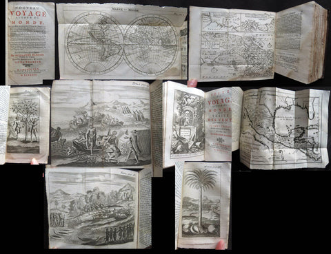
1723 William Dampier 2 Volumes of World Voyages to America Australia Asia - 20 x Maps & Plates
- Title : Nouveau Voyage Autour Du Monde...Ou l on decrite en particular l Isthme de l Amerique, plusieurs côtes et isles des Indes Occidentales...1723
- Size: 8vo
- Condition: (A) Very Good Condition
- Date : 1723
- Ref #: 93005
Description:
These two beautiful leather bound volumes of William Dampiers voyages to America, New Holland (Australia) and the East Indies, contains 5 titles with 20 maps & plates (some folding) and was published in Amsterdam by David Paul Marret in 1723 (dated)
These 2 volumes are the French translation of the voyages of the English explorer, ex-pirate and navigator, William Dampier, who became the first Englishman to explore parts of what is today Australia, and the first person to circumnavigate the world three times between 1679 & 1711. He has also been described as Australia\'s first natural historian, as well as one of the most important British explorers of the period between Sir Walter Raleigh and James Cook.
After impressing the British Admiralty with his book, A New Voyage Round the World, Dampier was given command of a Royal Navy ship and made important discoveries in western Australia, but was court-martialled for cruelty. On a later voyage, he rescued Alexander Selkirk, a former crew mate who may have inspired Daniel Defoe\'s Robinson Crusoe. Others influenced by Dampier include James Cook, Lord Nelson, Charles Darwin and Alfred Russel Wallace.
General Definitions:
Paper thickness and quality: - Heavy and stable
Paper color : - off white
Age of map color: -
Colors used: -
General color appearance: -
Paper size: - 8vo
Plate size: - 8vo
Margins: - Min 1/2in (12mm)
Imperfections:
Margins: - Please see below for condition report
Plate area: - Please see below for condition report
Verso: - Please see below for condition report
Background:
The two volumes contain the following 5 titles with 20 maps & plates.
Volume 1.
1. Nouveau Voyage Autour Du Monde...Ou l\'on decrite en particular l\'Isthme de l\'Amerique, plusieurs côtes et isles des Indes Occidentales, les Isles du Cap Verd, le passage par la Terre del Fuego, les côtes meridionales du Chili, du Perou & du Mexique; l\'Isle de Guam, Mindanao, & des autres Philippines, les isles orientales qui sont prés de Cambodie; de la Chine; Formosa; Luçon, Celebes, &c., la Nouvelle Hollande, les Isles de Sumatra, de Nicobar & de Sainte Helene & le Cap de Bonne Esperance...Ou l\'on traite des differens terroirs de tous ces pays, de leurs ports, des plantes, des fruits & des animaux qu\'on y trouve; de leurs habitans, de leurs coûtumes, de leur religion, de leur gouvernement, de leur negoce, &c....1723
This volume refers to Dampiers voyages to North & South America, East Indies, SE Asia, China, Australia & Africa.
Contains Title page, 8 maps & plates total of 340 pages.
a) Mappe-Monde - World map with Dampiers tracks.
b) Maps of the Isthmus of Panama and Central America
c) Print of Natives gathering fruit
d) Print of Dampier loading Gold from the New World
e) Voyage au tour du Monde title page
f) Map of Mexico & southern North America
g) Print of a battle in the East indies
h) Print of a coconut palm in East Indies
2. Suite du Voyage Autour du Monde... Avec un Traite Des Vents qui regnent dans toute..LA ZONE TORRIDE Enrichi de Cartes & de Figures..1723
This volume refers to the contuinuation of Dampiers voyages to North & South America, East Indies, SE Asia, China, Australia & Africa along with a description of global winds and tides.
Contains title page along with 6 maps & plates, 227 pages.
a) Engraved Voyage au Tour Du Monde
b) Print of ships offshore from the city of Manila in the Phillippines
c) View of Manila
d) 2nd print of ships offshore from the city of Manila in the Phillippines
e) Map of the Philippines islands of Banshee
f) Map of Pulocondor, Malayia
g) Print of Dampiers ship and compass rose
3. Traits des Vents Aliisez ou Reglez des Vents Frais ...1715
This volume refers again to globle winds & tides.
Contains title page 2 maps & 148 pages
a) Description of winds and tides in the eastern hemisphere
b) Description of winds and tides in the eastern hemisphere
Volume 2.
1. Voyage Autour Du Monde... Contenant une Description d\'Achin,
Ville de Sumatra, du Royaume de Tonquin & autres Places des Indes,
& de la Baye de Campeche. Ou l\'on traite des differens terroirs de tous ces pays, de leurs ports, des plantes, des fruits & des animaux qu\'on y trouve; de leurs
habitans, de leurs coûtumes, de leur religion, de leur gouvernement,
de leur negoce, &c...1723
This volume refers to the continuation of Dampiers travels in East Indies, SE Asia & Mexico
Contains title page, 4 maps & plates, 264 pages.
a) Royalty in Vietnam
b) Map of central & north America
b) Print of Vietnam
c) Map of Australia & East Indies
2. Voyages de Guillaume Dampier a la Baye de Campeche...1714
This volume refers to Dampiers travel to Campeche, Mexico.
Contains title page and 197 pages.
Condition Report: Two volumes bound in full leather with five raised bands to spines, and title label. Couple of minor chips to top of both spines. The leather is scuffed and little pitted/worn (see photos). Internally there are a couple of small chips to inner edges of front and rear end-papers. Inscription to front end-papers (Gift of W. Wood 1745) and bookplate to inside front board (Lord Sandys). The title page of volume III and following four or so leaves have damp staining, and there is light damp staining throughout Volume I & II. The damp staining has caused the leaves to become softer and little chipped, with some nicks/tears and chips. There is a tear/crease to top inner edge and chip to bottom corner of title page of volume I. Scattered pale foxing/browning. Several of the plates have occasional creases. Four leaves of volume III are gently detaching and two leaves of volume I are missing. A few leaves are a little faded. Overall VG, in readable with firm binding.
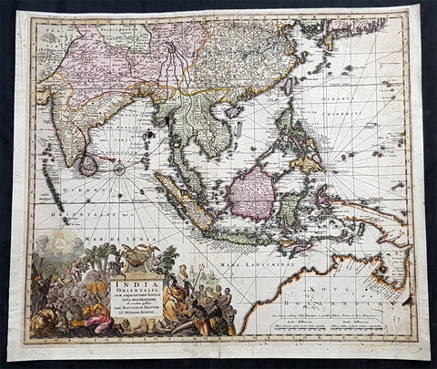
1730 Georg Seutter Large Antique Map Australia, China, SE Asia, Indonesia, India
- Title : India Orientalis cum Adjacentibus Insulis Nova Delineatione ob oculos posita..Matth. Seuttero
- Ref #: 93142
- Size: 24in x 20in (610mm x 510mm)
- Date : 1730
- Condition: (B) Good Condition
Description:
This large, beautifully hand coloured original antique map of the North & NW coastline of New Holland (Australia) East Asia, SE Asia, China, East Indies was published by Georg Mattraus Seutter in 1730.
The map is backed on 18th century contemporary paper and has old ink spots & lines but is overall a nice map and is priced accordingly.
General Definitions:
Paper thickness and quality: - Heavy and stable
Paper color : - off white
Age of map color: - Original
Colors used: - Yellow, green, blue, pink
General color appearance: - Authentic
Paper size: - 24in x 20in (610mm x 510mm)
Plate size: - 22 1/2in x 19in (565mm x 490mm)
Margins: - Min 1/2in (12mm)
Imperfections:
Margins: - Age toning, light soiling
Plate area: - Old ink marks & spots on map, light soiling, creasing
Verso: - Backed onto contemporary paper
Background:
The map extends from China, Japan and Persia in the North and in the south stretching from The Maldives east to Northern Australia. Of note, Australia continues to be attached to Nova Guinea, albeit with some hesitation, as the image extends outside the inner neat-line to convey this information - even though 20+ names are confidently engraved around Northern Australia Coastline.
The detail throughout Southeast Asia is informative and up-to-date and the print style typically strong.
The cartouche is one of Seutter\'s most ornate, with elaborate scenes from sea, land, jungle and mythology.
This map rarely appears on the market, as it was only included in select copies of Seutters atlas.

1730 George Seutter Large Antique Map of Australia, East Indies, SE Asia, China
- Title: India Orientalis cum Adjacentibus Insulis Nova Delineatione ob oculos posita ..Matth. Suettro.
- Date: 1730
- Condition: (A+) Condition
- Ref: 43155
- Size: 25 ½in x 21 ½in (650mm x 545mm)
Description: This large, scarce & beautifully hand coloured original map of Australia & SE Asia was published by Georg Mattraus Seutter in 1730. This is one of the best examples of this map I have seen, especially with the colouring. In excellent condition, a must in any Australian or SE Asian collection.
Condition Report
Paper thickness and quality: - Heavy and stable
Paper color: - off white
Age of map color: - Original & later
Colors used: - Yellow, pink, green, orange, blue
General color appearance: - Authentic
Paper size: - 25 ½in x 21 ½in (650mm x 545mm)
Plate size: - 23in x 19 1/4in (580mm x 490mm)
Margins: - Min 1in (25mm)
Imperfections:
Margins: - None
Plate area: - None
Verso: - None
Background: The map extends from China, Japan and Persia in the North and in the south stretching from The Maldives east to Northern Australia. Of note, Australia continues to be attached to Nova Guinea, albeit with some hesitation, as the image extends outside the inner neat-line to convey this information - even though 20+ names are confidently engraved around Northern Australia Coastline. The detail throughout Southeast Asia is informative and up-to-date and the print style typically strong. The cartouche is one of Seutter's most ornate, with elaborate scenes from sea, land, jungle and mythology. This map rarely appears on the market, as it was only included in select copies of Seutters atlas. (Ref: Norwich; M&B; Tooley)
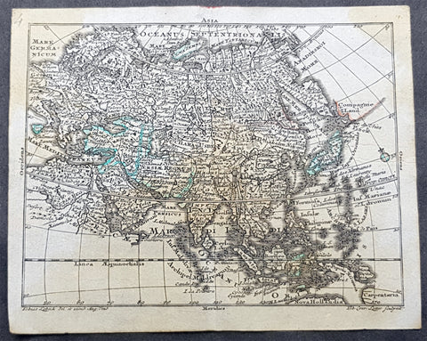
1747 Tobias Lotter Antique Miniature Map of Asia, Gulf of Carpentaria, Australia
- Title : Asia
- Size: 5 1/2in x 4 1/2in (140mm x 115mm)
- Condition: (A) Very Good Condition
- Date : 1747
- Ref #: 93110
Description:
This original copper plate engraved antique miniature map of Asia by Tobias Lotter was published in the 1747 edition of Atlas Geographicus Portatilis XXIX mappis orbis habitabilis regna exhibens.
General Definitions:
Paper thickness and quality: - Heavy and stable
Paper color : - off white
Age of map color: - Original
Colors used: - Green
General color appearance: - Authentic
Paper size: - 5 1/2in x 4 1/2in (140mm x 115mm)
Plate size: - 5 1/2in x 4 1/2in (140mm x 115mm)
Margins: - Min 1/4in (5mm)
Imperfections:
Margins: - Light age toning
Plate area: - Light age toning
Verso: - Light age toning
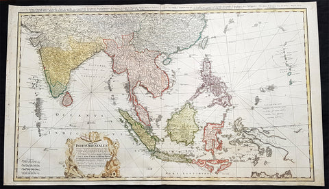
1748 Homann Large Antique Map of Australia, Indonesia, China, SE Asia, India
- Title : Carte Des Indes Orientalis...1748
- Ref #: 93411
- Size: 36 1/4in x 21 1/4in (920mm x 540mm)
- Date : 1748
- Condition: (A+) Fine Condition
Description:
This very large original hand coloured copper plate engraved antique map map of India, SE Asia, The East Indies, Philippines, New Guinea & Australia was engraved by Sebastian Dorn in 1748, dated, and published by the Homann firm.
General Definitions:
Paper thickness and quality: - Light and stable
Paper color : - off white
Age of map color: - Original
Colors used: - Yellow, green, blue, pink
General color appearance: - Authentic
Paper size: - 36 1/4in x 21 1/4in (920mm x 540mm)
Plate size: - 35 1/2in x 20 1/2in (900mm x 515mm)
Margins: - Min 1/2in (12mm)
Imperfections:
Margins: - Light soiling
Plate area: - None
Verso: - Light soiling
Background:
The map is based upon the sea charts created by Jean-Batiste de Mannevillette (1707-80), for the first edition of his Le Neptune Oriental, the first sea atlas of Asian Waters. Mannevillette apprenticed under the great royal cartographer Guillaume De L\'Isle. He then joined the maritime service of the Compagnie des Indes, eventually attaining the rank of captain. Upon his return to Paris, Mannevillette was appointed as director of the Dépôt des Cartes et Plans de la Navigation des Indes.
In 1745, Manneveillette published the first edition of his sea atlas of Asian waters, Le Neptune Oriental. The high quality of Mannevillette\'s charts won him the acclaim of both mariners and academics alike, and he was admitted as a fellow of the Academy of Sciences. He published a second, heavily revised, edition of the Neptune Oriental in 1775.

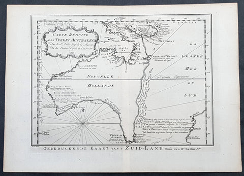
1753 Bellin Antique Map of Australia & New Zealand - Carte Reduite.....Australes
- Title : Carte Reduite des Terres Australes pour Servir a l'Histoire des Voyages...1753
- Ref #: 17027
- Size: 13 1/2in x 10in (340mm x 255mm)
- Date : 1753
- Condition: (A+) Fine Condition
Description:
This original copper plate engraved antique map of Australia - one of the earliest, near complete maps, dedicated to the Island Continent - was engraved in 1753 by Jacques Nicolas Bellin - date engraved in the title -and was published in Antoine Prevosts Histoire Generale Des Voyages.
Background: This is one of the few 18th century maps to focus on the Australian continent prior to Cook's famous first voyage from 1768-1771. Mainland Australia is connected to both Tasmania (Terre de Van Diemen) and Papua New Guinea (Nouv. Guinee). Along the imaginary eastern coastline is a note that reads: "I suppose that the land of Diemen can join with the land of the Holy Ghost, but this is without proof." A partial coastline of New Zealand is shown peeking out of the corner of the map, with a note that it was discovered by Abel Tasman in 1642 and speculation that it might be part of a great southern continent. This is an important map of Australia depicting the interesting theories made prior to exploration of the region later in the 18th century. (Ref: Tooley; M&B)
General Description:
Paper thickness and quality: - Heavy and stable
Paper color: - off white
Age of map color: -
Colors used: -
General color appearance: -
Paper size: - 13 1/2in x 10in (340mm x 255mm)
Plate size: - 11 1/2in x 8 1/2in (295mm x 215mm)
Margins: - Min 1in (25mm)
Imperfections:
Margins: - None
Plate area: - Folds as issued
Verso: - None

1753 Bellin Antique Map of Australia & New Zealand - Carte Reduite.....Australes
- Title : Carte Reduite des Terres Australes pour Servir a l'Histoire des Voyages...1753
- Ref #: 17040
- Size: 15in x 10in (380mm x 255mm)
- Date : 1753
- Condition: (A+) Fine Condition
Description:
This original beautifully hand coloured copper plate engraved antique map of Australia - one of the earliest, near complete maps, dedicated to the Island Continent - was engraved in 1753 by Jacques Nicolas Bellin - date engraved in the title -and was published in the 1753 edition of Prevosts Histoire Generale Des Voyages.
Background: This is one of the few 18th century maps to focus on the Australian continent prior to Cook's famous first voyage from 1768-1771. Mainland Australia is connected to both Tasmania (Terre de Van Diemen) and Papua New Guinea (Nouv. Guinee). Along the imaginary eastern coastline is a note that reads: "I suppose that the land of Diemen can join with the land of the Holy Ghost, but this is without proof." A partial coastline of New Zealand is shown peeking out of the corner of the map, with a note that it was discovered by Abel Tasman in 1642 and speculation that it might be part of a great southern continent. This is an important map of Australia depicting the interesting theories made prior to exploration of the region later in the 18th century. (Ref: Tooley; M&B)
General Description:
Paper thickness and quality: - Heavy and stable
Paper color: - off white
Age of map color: - Early
Colors used: - Yellow, green, red, brown.
General color appearance: - Authentic and fresh
Paper size: - 15in x 10in (380mm x 255mm)
Plate size: - 11 1/2in x 8 1/2in (295mm x 215mm)
Margins: - Min 1in (25mm)
Imperfections:
Margins: - None
Plate area: - Folds as issued
Verso: - None
1753 Jacques Nicolas Bellin Antique Map of Australia & New Zealand, Pre Captain Cook
- Title : Carte Reduite des Terres Australes pour Servir a l Histoire des Voyages...1753
- Size: 14in x 10in (355mm x 255mm)
- Condition: (A+) Fine Condition
- Date : 1753
- Ref #: 80279
Description:
This important, early original copper-plate engraved antique map of Australia, New Zealand & New Guinea, one of the earliest near complete maps dedicated to the Island Continent, by Jacques Nicolas Bellin was engraved by Jakob van der Schley in 1753 - date engraved in the title cartouche - and was published by Abbé Prévosts in the 1755 Dutch edition of Histoire Géneral des Voyages.
General Definitions:
Paper thickness and quality: - Heavy and stable
Paper color : - off white
Age of map color: -
Colors used: -
General color appearance: -
Paper size: - 14in x 10in (355mm x 255mm)
Plate size: - 11 3/4in x 8 1/2in (295mm x 215mm)
Margins: - Min 1in (20mm)
Imperfections:
Margins: - None
Plate area: - None
Verso: - None
Background:
This is one of the few maps prior to the mid 18th century to focus specifically on the Australian continent & surrounding islands, prior to Captain James Cooks famous first voyage to the south pacific, under secret instruction from the British Admiralty, between 1768 & 1771.
Mainland Australia is connected to both Tasmania (Terre de Van Diemen) and Papua New Guinea (Nouv. Guinee) Along the imaginary eastern coastline is a note that reads: I suppose that the land of Diemen can join with the land of Terre du St Esprit, but this is without proof. A partial coastline of New Zealand is shown peeking out of the corner of the map, with a note of discovery along the western coastline by Abel Tasman in 1642 and speculation that it might be part of a great southern continent, Terra Australis.
Jakob van der Schley aka Jakob van Schley 1715 - 1779 was a Dutch draughtsman and engraver. He studied under Bernard Picart (1673-1733) whose style he subsequently copied. His main interests were engraving portraits and producing illustrations for La Vie de Marianne by Pierre Carlet de Chamblain de Marivaux (1688-1763), published in The Hague between 1735 and 1747. He also engraved the frontispieces for a 15-volume edition of the complete works of Pierre de Brantôme (1540-1614), Oeuvres du seigneur de Brantôme, published in The Hague in 1740. Most of the plates in the Hague edition of Prévosts Histoire générale des voyages are signed by van der Schley.
This is an important map of Australia depicting the interesting theories & misconceptions of the great southern land just prior to the extensive exploration & discoveries of the region in the later part of the 18th century. (Ref: Tooley; M&B)
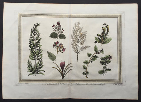
1755 Prevost Antique Print Plants found by William Dampier in Australia in 1688
- Title: 1.2.3.4. Plantee de la Nle. Hollande 5.6.7.8. Plantes que Dampierre trouva au Brezil
- Date: 1755
- Size: 14in x 10in (355mm x 255mm)
- Ref: 26047
- Condition : (A+) Fine Condition
Description:
This fine, original copper-plate engraved antique print of plants and flowers first discovered in New Holland (Australia) in 1688 & Brazil by William Dampier first published in his 1697 edition of William Dampiers Voyages and Travels. by Jakob van Schley in 1755 - after Dampier - was published in Antoine François Prevosts 15 volumes of Histoire Generale des Voyages written by Prevost & other authors between 1746-1790.
In 1688 William Dampier (1652-1715) was the first Englishman to land in Australia. He arrived on the west coast in privateer ship Cygnet which was grounded for repairs at Shark Bay for two months. As he had done in Brazil, and would also do in New Guinea, Dampier sketched flora, fauna and native people during this time. After his return to England these simple sketches were published in 1697 in Dampier’s book A New Voyage Round the World. Usually nature discoveries were published with contemporary colour - each hand-coloured in accordance with the drawing from the artist on the voyage, but paintboxes were probably not priority for pirates, and his botanical engravings remained uncoloured when published.
During more than twelve years, in just as many ships and various voyages, Dampier circumnavigated the world three times – and became the first to do so. His stories of his travels were well-received by the public and he revised and published to accommodate their popularity. Travel was something that most people could only be read about, and stories of discoveries were popular everywhere. From 1705 Dampier’s “Voyages and Discoveries” were even published in France.
Dampier arrived on the west coast of Australia in 1688 Cygnet was grounded for repairs for two months at Shark Bay. As he had done in Brazil and would do in New Guinea, William Dampier sketched local flowers, plants and grasses, birds and animals, and natives. He was not impressed with the terrain. After his return to England, copperplate engravings from these simple sketches were published in 1697 for Dampier’s A New Voyage Round the World. Usually nature discoveries were published with contemporary colour - each hand-coloured in accordance with the drawing from the artist on the voyage, but Dampier probably didn’t have a paintbox with him, so his botanical engravings remained uncoloured when published.
General Definitions:
Paper thickness and quality: - Heavy and stable
Paper color : - off white
Age of map color: - Early
Colors used: - Yellow, green, pink
General color appearance: - Authentic
Paper size: - 15in x 10in (385mm x 255mm)
Plate size: - 14in x 8 1/2in (355mm x 220mm)
Margins: - Min 1in (25mm)
Imperfections:
Margins: - None
Plate area: - None
Verso: - None
Background:
One of Antoine Francois Prevosts monumental undertakings was his history of exploration & discovery in 15 volumes titledHistoire Générale des Voyages written between 1746-1759 and was extended to 20 volumes after his death by various authors.
The 20 volumes cover the early explorations & discoveries on 3 continents: Africa (v. 1-5), Asia (v. 5-11), and America (v. 12-15) with material on the finding of the French, English, Dutch, and Portugese.
A number of notable cartographers and engravers contributed to the copper plate maps and views to the 20 volumes including Nicolas Bellin, Jan Schley, Chedel, Franc Aveline, Fessard, and many others.
The African volumes cover primarily coastal countries of West, Southern, and Eastern Africa, plus the Congo, Madagascar, Arabia and the Persian Gulf areas.
The Asian volumes cover China, Korea, Tibet, Japan, Philippines, and countries bordering the Indian Ocean.
Volume 11 includes Australia and Antarctica.
Volumes 12-15 cover voyages and discoveries in America, including the East Indies, South, Central and North America.
Volumes 16-20 include supplement volumes & tables along with continuation of voyages and discoveries in Russia, Northern Europe, America, Asia & Australia.
Jakob van der Schley aka Jakob van Schley (1715 - 1779) was a Dutch draughtsman and engraver. He studied under Bernard Picart (1673-1733) whose style he subsequently copied. His main interests were engraving portraits and producing illustrations for \\\"La Vie de Marianne\\\" by Pierre Carlet de Chamblain de Marivaux (1688-1763) published in The Hague between 1735 and 1747.
He also engraved the frontispieces for a 15-volume edition of the complete works of Pierre de Brantôme (1540-1614), \\\"Oeuvres du seigneur de Brantôme\\\", published in The Hague in 1740.
He is also responsible for most of the plates in the Hague edition of Prévosts Histoire générale des voyages. (Ref: Tooley; M&B)
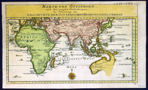
1760 Gebauers Antique Map of Australia, Pacific, East Indies, China, Middle East
- Title : Karte von Ostindien, nach den neuesten Entdeckungen zur Erleuterung der geschichteder ostindischen Handlungs Geselschaften
- Date : 1760
- Condition: (A) Very Good Condition
- Ref: 16283
- Size: 15in x 9in (380mm x 230mm)
Description:
This fine beautifully hand colured original antique German map of Australia and the East Indies & Africa was published Johann Justine Gebauers in 1760 prior to the discoveries of Captain Cook some 20 odd years later. Unusual and scarce map of the region.
This is a beautiful map, quite highly detailed and wonderfully hand coloured. Australia shown joined to PNG with notes on the explorers Dampier, de Wit and Van Nuits all reaching Australia in the previous 17th century. The West coast of New Zealand is shown with the earlier discoveries. (Ref: M&B; Tooley)
General Description:
Paper thickness and quality: - Heavy & stable
Paper color: - White
Age of map color: - Early
Colors used: - Blue, yellow, pink
General color appearance: - Authentic
Paper size: - 15in x 9in (380mm x 230mm)
Paper size: - 14in x 8 1/2in (355mm x 215mm)
Margins: - Min 1/4in (10mm)
Imperfections:
Margins: - None
Plate area: - Folds as issued
Verso: - None
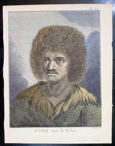
1774 Capt. Cook Antique Print a Portrait of Chief Tynah, Otoo of Tahiti in 1769
- Title : Otoo, Roi de Tahiti
- Ref : 21341
- Size: 10in x 8in (255mm x 205mm)
- Date : 1774
- Condition: (A+) Fine Condition
Description:
This fine original copper-plate engraved antique print a portrait of Chief Tynah (Otoo) of Tahiti Island, met by Captain James Cook during his 1st Voyage of Discovery in 1769, was engraved by Robert Benard - after Sydney Parkinson - and was published in the 1774 French edition of Capt. James Cooks 1st Voyage of Discovery to the South Seas by John Hawkesworth in An Account of the Voyages Undertaken by the Order of His Present Majesty for Making Discoveries in the Southern Hemisphere and Successively Performed by Commodore Byron, Captain Wallis, Captain Carteret, and Captain Cook, in the Dolphin, the Swallow, and the Endeavor, Drawn Up from the Journals Which Were Kept by the Several Commanders, and from the Papers of Joseph Banks. Paris, 1774.
General Definitions:
Paper thickness and quality: - Heavy and stable
Paper color : - off white
Age of map color: - Early
Colors used: - Yellow, brown, green
General color appearance: - Authentic
Paper size: - 10in x 8in (255mm x 205mm)
Plate size: - 9 1/2in x 7 1/4in (240mm x 185mm)
Margins: - Min 1/2in (12mm)
Imperfections:
Margins: - Light soiling in margins
Plate area: - None
Verso: - None
Background:
Tahiti previously also known as Otaheite is the largest island in the Windward group of French Polynesia. The island is located in the archipelago of the Society Islands in the central Southern Pacific Ocean.
The first European to have visited Tahiti according to existing records was lieutenant Samuel Wallis, who was circumnavigating the globe in HMS Dolphin, sighting the island on 18 June 1767, and eventually harboring in Matavai Bay. This bay was situated on the territory of the chiefdom of Pare-Arue, governed by Tu (Tu-nui-e-a a-i-te-Atua) and his regent Tutaha, and the chiefdom of Ha apape, governed by Amo and his wife Oberea (Purea). Wallis named the island King Georges Island. The first contacts were difficult, since on the 24 and 26 June 1767, Tahitian warriors in canoes showed aggression towards the British, hurling stones from their slings. In retaliation, the British sailors opened fire on the warriors in the canoes and on the hills. In reaction to this powerful counter-attack, the Tahitians laid down peace offerings for the British. Following this episode, Samuel Wallis was able to establish cordial relations with the female chieftain “Oberea “ (Purea) and remained on the island until 27 July 1767.
In July 1768, Captain James Cook was commissioned by the Royal Society and on orders from the Lords Commissioners of the Admiralty to observe the transit of Venus across the sun, a phenomenon that would be visible from Tahiti on 3 June 1769. He arrived in Tahitis Matavai Bay, commanding the HMS Endeavour on 12 April 1769. On 14 April, Cook met with Tutaha and Tepau. On 15 April, Cook picked the site for a fortified camp at Point Venus along with Banks, Parkinson, Daniel Solander, to protect Charles Greens observatory. The length of stay enabled them to undertake for the first time real ethnographic and scientific observations of the island. Assisted by the botanist Joseph Banks, and by the artist Sydney Parkinson, Cook gathered valuable information on the fauna and flora, as well as the native society, language and customs, including the proper name of the island, Otaheite. On 28 April, Cook met Purea and Tupaia, and Tupaia befriended Banks following the transit. On 21 June, Amo visited Cook, and then on 25 June, Pohuetea visited, signifying another chief seeking to ally himself with the British.
Cook and Banks circumnavigated the island from 26 June to 1 July. On the exploration, they met Ahio, chief of Ha apaiano o or Papenoo, Rita, chief of Hitia a, Pahairro, chief of Pueu, Vehiatua, chief of Tautra, Matahiapo, chief of Teahupo o, Tutea, chief of Vaira o, and Moe, chief of Afa Ahiti. In Papara, guided by Tupaia, they investigated the ruins of Mahaiatea marae, an impressive structure containing a stone pyramid or ahu, measuring 44 feet high, 267 feet long and 87 feet wide. Cook and the Endeavour departed Tahiti on 13 July 1769, taking Raiatean navigator Tupaia along for his geographic knowledge of the islands.
Cook returned to Tahiti between 15 August and 1 September 1773, greeted by the chiefs Tai and Puhi, besides the youg ari i Vehiatua II and his stepfather Ti itorea. Cook anchored in Vaitepiha Bay before returning to Point Venus where he met Tu, the paramount chief. Cook picked up two passengers from Tahiti during this trip, Porea and Mai, with Hitihiti later replacing Porea when Cook stopped at Raiatea. Cook took Hitihiti to Tahiti on 22 April, during his return leg. Then, Cook departed Tahiti on 14 May 1774.
During his final visit, Cook returned Mai to Tahiti on 12 Aug. 1777, after Mais long visit in England. Cook also brought two Maori from Queen Charlotte Sound, Te Weherua and Koa. Cook first harbored in Vaitepiha Bay, where he visited Vehiatua II s funeral bier and the prefabricated Spanish mission house. Cook also met Vehiatua III, and inscribed on the back of the Spanish cross, Georgius tertius Rex Annis 1767, 69, 73, 74 & 77, as a counterpoint to Christus Vincit Carolus III imperat 1774 on the front. On 23 Aug., Cook sailed for Matavai Bay, where he met Tu, his father Teu, his mother Tetupaia, his brothers Ari ipaea and Vaetua, and his sisters Ari ipaea-vahine, Tetua-te-ahamai, and Auo. Cook also observed a human sacrifice, taata tapu, at the Utu-ai-mahurau marae, and 49 skulls from previous victims.
On 29 Sept. 1777, Cook sailed for Papetoai Bay on Moorea. Cook met Mahine in an act of friendship on 3 Oct., though he was an enemy of Tu. When a goat kid was stolen on 6 Oct., Cook in a rampage, ordered the burning of houses and canoes until it was returned. Cook sailed for Huahine on 11 Oct., Raiatea on 2 Nov., and Borabora on 7 Dec.
On 26 October 1788, HMS Bounty, under the command of Captain William Bligh, landed in Tahiti with the mission of carrying Tahitian breadfruit trees (Tahitian: uru) to the Caribbean. Sir Joseph Banks, the botanist from James Cooks first expedition, had concluded that this plant would be ideal to feed the African slaves working in the Caribbean plantations at very little cost. The crew remained in Tahiti for about five months, the time needed to transplant the seedlings of the trees. Three weeks after leaving Tahiti, on 28 April 1789, the crew mutinied on the initiative of Fletcher Christian. The mutineers seized the ship and set the captain and most of those members of the crew who remained loyal to him adrift in a ships boat. A group of mutineers then went back to settle in Tahiti.
Although various explorers had refused to get involved in tribal conflicts, the mutineers from the Bounty offered their services as mercenaries and furnished arms to the family which became the Pōmare Dynasty. The chief Tū knew how to use their presence in the harbours favoured by sailors to his advantage. As a result of his alliance with the mutineers, he succeeded in considerably increasing his supremacy over the island of Tahiti.
Sydney Parkinson 1745 – 71 was draughtsman to the botanist Sir Joseph Banks on James Cook’s first voyage to the Pacific in 1768. He died of dysentery in 1771, on the homeward voyage.
Parkinson was the first European artist to create drawings of Indigenous Australian, Maori & South Sea peoples, as well as landscapes, from direct observation. Hundreds of his original drawings survive in the British Museum. He is particularly remembered for his plant illustrations which were later used to create the lavish plates for Joseph Banks’ Florilegium.
When the Endeavour returned to England in 1772, a dispute arose between Joseph Banks and Sydney’s brother, Stanfield Parkinson. As his employer, Banks claimed rights to Sydney’s drawings, papers and collections made on the voyage. Stanfield claimed that Sydney had willed them to his family. Banks lent the Parkinson family Sydney’s journal and drawings with instructions that they were not to be published, however Stanfield disregarded this and arranged for A Journal of a voyage to the South Seas to be printed from Sydney’s account of the voyage.
Banks managed to suppress Stanfield’s publication until the official account of the voyage, edited by John Hawkesworth, appeared. In return for Parkinson’s papers, Banks paid Stanfield Parkinson 500 pounds for balance of wages due to Sydney, but the dispute did not end there. Stanfield further accused Banks of retaining items collected by Sydney which were intended for his relatives. Stanfield Parkinson was declared insane soon after the publication of Sydney Parkinson’s Journal and died in an asylum.
John Hawkesworth An English writer and journalist, Hawkesworth was commissioned by the British Admiralty to edit for publication the narratives of its officers’ circumnavigations. He was given full access to the journals of the commanders and the freedom to adapt and re-tell them in the first person. Cook was already on his way back from his second Pacific voyage, temporarily docked at Cape Town (South Africa), when he first saw the published volumes: he was mortified and furious to find that Hawkesworth claimed in the introduction that Cook had seen and blessed (with slight corrections) the resulting manuscript. (In his defense, Hawkesworth also had been a victim of misunderstanding.) Cook had trouble recognizing himself. Moreover, the work was full of errors and commentary introduced by Hawkesworth and, in Cook’s view, too full of Banks, who had promoted himself and the publication. Still, the work was popular; the first edition sold out in several months.
Robert Bénard 1734 – 1777 was an 18th-century French engraver.
Specialized in the technique of engraving, Robert Ménard is mainly famous for having supplied a significant amount of plates (at least 1,800) to the Encyclopédie by Diderot & d\'Alembert from 1751.
Later, publisher Charles-Joseph Panckoucke reused many of his productions to illustrate the works of his catalog.
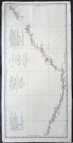
1774 Capt. Cook Original Antique Map of East Coast Survey of Australia in 1769-70
- Title : Carte De La Nle Galles Meridle ou de la Cote Orientale de la N.le Hollande...en 1770: Charte von Neu Sud Wallis oder von der Oestlichen Kuste von Neu Holland...MDCCLXX
- Ref : 35510
- Size: 32 1/4in x 16in (820mm x 405mm)
- Date : 1774
- Condition: (A+) Fine Condition
Description:
This fine original copper-plate engraved, large antique map, a chart of the East Coast of Australia - from Point Hicks in Victoria to Cape York in Queensland - by Captain James Cook during his first Voyage of Discovery to the South Seas, in 1769-70, was engraved by J G Schmidi - after Captain Cook - and was published in the 1774 German translation of John Hawkesworths publication An Account of the Voyages Undertaken by the Order of His Present Majesty for Making Discoveries in the Southern Hemisphere and Successively Performed by Commodore Byron, Captain Wallis, Captain Carteret, and Captain Cook, in the Dolphin, the Swallow, and the Endeavor, Drawn Up from the Journals Which Were Kept by the Several Commanders, and from the Papers of Joseph Banks
General Definitions:
Paper thickness and quality: - Heavy and stable
Paper color : - off white
Age of map color: -
Colors used: -
General color appearance: -
Paper size: - 32 1/4in x 16in (820mm x 405mm)
Plate size: - 31in x 15in (790mm x 380mm)
Margins: - Min 1/2in (12mm)
Imperfections:
Margins: - None
Plate area: - Folds as issued
Verso: - None
Background:
1st Chart of the East Coast of Australia
Captain James Cook is considered one of the most talented Surveyors & Map Makers of any age, for Cook, the production of a new chart was his principal reason for going to sea. His charts were aimed at fellow seamen so he incorporated as much information as possible while employing an economy of style and little elaboration. The quality of his charts can be confirmed by the fact that some survey details from Newfoundland to New Zealand & Australias East Coast could still be safely used over one hundred years later. His last piece of the New Zealand hydrographic chart was only removed in the 1990s.
Prior to the Endeavour voyage in 1768 to the South Seas, most existing charts of the Pacific were poor and imprecise and were virtually useless to Cook. Cook therefore had a largely blank canvas when he entered the Pacific. Four charts produced by Cook in the Pacific, during his 1st voyage, serve to demonstrate his ability and output. The charts of Tahiti, the New Hebrides (Vanuatu) New Zealand & the East Coast of Australia.
On leaving Tahiti and the other Society Islands, Cook made a short attempt to find Terra Australis but the poor condition of the Endeavour soon forced him to head for New Zealand. Reaching there in early October 1769, Cook would remain for six months during which time he made a circumnavigation showing it comprised two main islands. Cook’s chart of New Zealand is one of his most famous (and rightly so) as it represents some of his best work with New Zealand immediately recognisable.
After mapping New Zealand Cook then set course westwards, intending to strike for Van Diemens Land (present-day Tasmania, sighted by Tasman) to establish whether or not it formed part of the fabled southern continent. However, they were forced to maintain a more northerly course owing to prevailing gales, and sailed onwards until one afternoon when land was sighted, which Cook named Point Hicks. Cook calculated that Van Diemens Land ought to lie due south of their position, but having found the coastline trending to the south-west, recorded his doubt that this landmass was connected to it. This point was on the south-eastern coast of the Australian continent, and in doing so his expedition became the first recorded Europeans to have encountered its eastern coastline. In his journal, Cook recorded the event thus:
.........the Southermost Point of land we had in sight which bore from us W1/4S I judged to lay in the Latitude of 38°..0\' S° and in the Longitude of 211°..07\' W t from the Meridion of Greenwich. I have named it Point Hicks, because Leuit t Hicks was the first who discover\'d this land...........
The ships log recorded that land was sighted at 6 a.m. on Thursday 19 April 1770. Cooks log used the nautical date, which, during the 18th century, assigned the same date to all ships events from noon to noon, first p.m. and then a.m. That nautical date began twelve hours before the midnight beginning of the like-named civil date. Furthermore, Cook did not adjust his nautical date to account for circumnavigation of the globe until he had travelled a full 360° relative to the longitude of his home British port, either toward the east or west. Because he travelled west on his first voyage, this a.m. nautical date was the morning of a civil date 14 hours slow relative to his home port (port−14h). Because the south-east coast of Australia is now regarded as being 10 hours ahead relative to Britain, that date is now called Friday, 20 April.
The landmark of this sighting is generally reckoned to be a point lying about half-way between the present-day towns of Orbost and Mallacoota on the south-eastern coast of the state of Victoria. A survey done in 1843 ignored or overlooked Cooks earlier naming of the point, giving it the name Cape Everard. On the 200th anniversary of the sighting, the name was officially changed back to Point Hicks.
Endeavour continued northwards along the coastline, keeping the land in sight with Cook charting and naming landmarks as he went. A little over a week later, they came across an extensive but shallow inlet, and upon entering it moored off a low headland fronted by sand dunes. James Cook and crew made their first landing on the continent, at a place now known as Botany Bay, on the Kurnell Peninsula and made contact of a hostile nature with the Gweagal Aborigines, on 29 April.[b] At first Cook bestowed the name Sting-Ray Harbour to the inlet after the many such creatures found there; this was later changed to Botanist Bay[27] and finally Botany Bay after the unique specimens retrieved by the botanists Joseph Banks, Daniel Solander and Herman Spöring.
This first landing site was later to be promoted (particularly by Joseph Banks) as a suitable candidate for situating a settlement and British colonial outpost. However, almost 18 years later, when Captain Arthur Phillip and the First Fleet arrived in early 1788 to establish an outpost and penal colony, they found that the bay and surrounds did not live up to the promising picture that had been painted. Instead, Phillip gave orders to relocate to a harbour a few kilometres to the north, which Cook had named Port Jackson but had not further explored. It was in this harbour, at a place Phillip named Sydney Cove, that the settlement of Sydney was established. The settlement was for some time afterwards still referred to generally as Botany Bay. The expeditions scientific members commenced the first European scientific documentation of Australian fauna and flora.
At Cooks original landing contact was made with the local Australian Aboriginal inhabitants. As the ships sailed into the harbour, they noticed Aborigines on both of the headlands. At about 2 pm they put the anchor down near a group of six to eight huts. Two Aborigines, a younger and an older man, came down to the boat.[citation needed] They did not accept the offer of gifts from Cook, whose lack of knowledge of Aboriginal custom may have prevented him from behaving acceptably in such exchanges. A musket was fired over their heads, which wounded the older man slightly, and he ran towards the huts. He came back with other men and threw spears at Cooks men, although they did no harm.[citation needed] They were chased off after two more rounds were fired.[citation needed] The adults had left, but Cook found several Aboriginal children in the huts, and left some beads with them as a gesture of friendship.
Cook continued northwards, charting along the coastline. He stopped at Bustard Bay (now known as 1770) at 8 o’clock on 23 May 1770 in 5 fathoms water on a sandy bottom at the South point of the Bay. Cook recounted that his clerk, Orton, had been molested while dead drunk that night, the perpetrators cutting off not only his clothes but also parts of his ears. Cook suspended and sent below the suspect Magra.[28] On 24 May Cook and Banks and others went ashore. He sounded the channel (now known as Round Hill Creek) and found a freshwater stream, noting there was room for a few ships to safely anchor. He noted a great deal of smoke on the hills and inspected one of the closest group of 10 fires around which were scattered cockle shells and other evidence of aboriginal occupation.
A mishap occurred when Endeavour ran aground on a shoal of the Great Barrier Reef, on 11 June 1770. The ship was seriously damaged and his voyage was delayed almost seven weeks while repairs were carried out on the beach (near the docks of modern Cooktown, at the mouth of the Endeavour River). While there, Joseph Banks, Herman Spöring and Daniel Solander made their first major collections of Australian flora. The crews encounters with the local Aboriginal people were mainly peaceable; from the group encountered here the name kangaroo entered the English language, coming from the local Guugu Yimidhirr word for a kind of Grey Kangaroo, gangurru (pronounced [ɡ̊aŋuru])
Once repairs were complete the voyage continued, eventually passing by the northernmost point of Cape York Peninsula and then sailing through Torres Strait between Australia and New Guinea, earlier navigated by Luis Váez de Torres in 1606. Having rounded the Cape, Cook landed on Possession Island on 22 August, where he claimed the entire coastline he had just explored (later naming the region New South Wales) for the British Crown.
In negotiating the Torres Strait past Cape York, Cook also put an end to the speculation that New Holland and New Guinea were part of the same land mass.
John Hawkesworth An English writer and journalist, Hawkesworth was commissioned by the British Admiralty to edit for publication the narratives of its officers’ circumnavigations. He was given full access to the journals of the commanders and the freedom to adapt and re-tell them in the first person. Cook was already on his way back from his second Pacific voyage, temporarily docked at Cape Town (South Africa), when he first saw the published volumes: he was mortified and furious to find that Hawkesworth claimed in the introduction that Cook had seen and blessed (with slight corrections) the resulting manuscript. (In his defense, Hawkesworth also had been a victim of misunderstanding.) Cook had trouble recognizing himself. Moreover, the work was full of errors and commentary introduced by Hawkesworth and, in Cook’s view, too full of Banks, who had promoted himself and the publication. Still, the work was popular; the first edition sold out in several months.
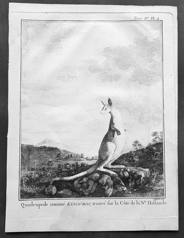
1774 Capt. Cook, S. Parkinson & G. Stubbs - Antique Print Australian Kangaroo in 1770
- Title : Quadrupede nomme Kanguroo trouve fur la Cote de la N.Hollande
[The Kanguroo, an Animal found on the Coast of New Holland] - Ref : 35016
- Size: 10in x 8in (255mm x 205mm)
- Date : 1774
- Condition: (A+) Fine Condition
Description:
This fine original copper-plate engraved antique print of a Kangaroo, first sketched by Sydney Parkinson onboard HMS Endeavour during Cooks first voyage in 1770, whilst laid up at Endeavour River in northern Queensland, was engraved by Robert Benard, after a painting by the famous English Artist George Stubbs in 1772. This original engraving was published in the 1774 French edition of Capt. James Cooks 1st Voyage of Discovery to the South Seas by John Hawkesworth in An Account of the Voyages Undertaken by the Order of His Present Majesty for Making Discoveries in the Southern Hemisphere and Successively Performed by Commodore Byron, Captain Wallis, Captain Carteret, and Captain Cook, in the Dolphin, the Swallow, and the Endeavor, Drawn Up from the Journals Which Were Kept by the Several Commanders, and from the Papers of Joseph Banks. Paris, 1774.
From Sydney Parkinsons Journal........soon after we arrived in the bay, we laid the ship on a steep bank, on the side of a river; set up tents on shore, unloaded her, carried all the cargo and provisions into them, and there lodged and accommodated our sick.
On the 22d, we examined the ship’s bottom, and found a large hole; through the planks into the hold, which had a piece of coral-rock, half a yard square, sticking in it: the same rock, therefore, that endangered us, yielded us the principal means of our redemption; for, had not this fragment intruded into the leak, in all probability the ship would have sunk.
We lost no time, but immediately set about repairing the ship’s bottom, and in a few days made it sound again. In the mean time, the boats were sent out, in search of another passage, which they found, and returned to the ship on the 3d of July.
On the 4th of July, the ship was carried to the other side of the river, and examined thoroughly; but, being found in good condition, she was soon placed in her former station; where she was loaded, and properly fitted to proceed on the voyage.
During the time we staid here, we picked up a great many natural curiosities from the reef we struck upon, consisting of a variety of curious shells, most of which were entirely new to Mr. Banks and Dr. Solander ...
Of quadrupeds, there are goats, wolves, a small red animal about the size of a squirrel; a spotted one of the viverra kind, and an animal of a kind nearly approaching the mus genus, about the size of a grey-hound, that had a head like a fawn’s; lips and ears, which it throws back, like a hare’s; on the upper jaw six large teeth; on the under one two only; with a short and small neck, near to which are the fore-feet, which have five toes each, and five hooked claws; the hinder legs are long, especially from the last joint, which, from the callosity below it, seems as if it lies flat on the ground when the animal descends any declivity; and each foot had four long toes, two of them behind, placed a great way back, the inner one of which has two claws; the two other toes were in the middle, and resembled a hoof, but one of them was much larger than the other. The tail, which is carried like a grey-hound’s, was almost as long as the body, and tapered gradually to the end. The chief bulk of this animal is behind; the belly being largest, and the back rising toward the posteriors. The whole body is covered with short ash-coloured hair; and the flesh of it tasted like a hare’s, but has a more agreeable flavour................
General Definitions:
Paper thickness and quality: - Heavy and stable
Paper color : - off white
Age of map color: -
Colors used: -
General color appearance: -
Paper size: - 10in x 8in (255mm x 205mm)
Plate size: - 9 1/2in x 7 1/4in (240mm x 185mm)
Margins: - Min 1/2in (12mm)
Imperfections:
Margins: - Light soiling in margins
Plate area: - None
Verso: - None
Background:
Sydney Parkinson 1745 – 71 was draughtsman to the botanist Sir Joseph Banks on James Cook’s first voyage to the Pacific in 1768. He died of dysentery in 1771, on the homeward voyage.
Parkinson was the first European artist to create drawings of Indigenous Australian, Maori & South Sea peoples, as well as landscapes, from direct observation. Hundreds of his original drawings survive in the British Museum. He is particularly remembered for his plant illustrations which were later used to create the lavish plates for Joseph Banks’ Florilegium.
When the Endeavour returned to England in 1772, a dispute arose between Joseph Banks and Sydney’s brother, Stanfield Parkinson. As his employer, Banks claimed rights to Sydney’s drawings, papers and collections made on the voyage. Stanfield claimed that Sydney had willed them to his family. Banks lent the Parkinson family Sydney’s journal and drawings with instructions that they were not to be published, however Stanfield disregarded this and arranged for A Journal of a voyage to the South Seas to be printed from Sydney’s account of the voyage.
Banks managed to suppress Stanfield’s publication until the official account of the voyage, edited by John Hawkesworth, appeared. In return for Parkinson’s papers, Banks paid Stanfield Parkinson 500 pounds for balance of wages due to Sydney, but the dispute did not end there. Stanfield further accused Banks of retaining items collected by Sydney which were intended for his relatives. Stanfield Parkinson was declared insane soon after the publication of Sydney Parkinson’s Journal and died in an asylum.
John Hawkesworth An English writer and journalist, Hawkesworth was commissioned by the British Admiralty to edit for publication the narratives of its officers’ circumnavigations. He was given full access to the journals of the commanders and the freedom to adapt and re-tell them in the first person. Cook was already on his way back from his second Pacific voyage, temporarily docked at Cape Town (South Africa), when he first saw the published volumes: he was mortified and furious to find that Hawkesworth claimed in the introduction that Cook had seen and blessed (with slight corrections) the resulting manuscript. (In his defense, Hawkesworth also had been a victim of misunderstanding.) Cook had trouble recognizing himself. Moreover, the work was full of errors and commentary introduced by Hawkesworth and, in Cook’s view, too full of Banks, who had promoted himself and the publication. Still, the work was popular; the first edition sold out in several months.
Robert Bénard 1734 – 1777 was an 18th-century French engraver.
Specialized in the technique of engraving, Robert Ménard is mainly famous for having supplied a significant amount of plates (at least 1,800) to the Encyclopédie by Diderot & d\'Alembert from 1751.
Later, publisher Charles-Joseph Panckoucke reused many of his productions to illustrate the works of his catalog.
George Stubbs ARA 1724 – 1806 was an English painter, best known for his paintings of horses. His most famous work is probably Whistlejacket, a painting of a prancing horse commissioned by the 2nd Marquess of Rockingham, which is now in the National Gallery in London. This and two other paintings carried out for Rockingham break with convention in having plain backgrounds. Throughout the 1760s he produced a wide range of individual and group portraits of horses, sometimes accompanied by hounds. He often painted horses with their grooms, whom he always painted as individuals. Meanwhile, he also continued to accept commissions for portraits of people, including some group portraits. From 1761 to 1776 he exhibited at the Society of Artists of Great Britain, but in 1775 he switched his allegiance to the recently founded but already more prestigious Royal Academy of Arts.
Stubbs also painted more exotic animals including lions, tigers, giraffes, monkeys, and rhinoceroses, which he was able to observe in private menageries. His painting of a kangaroo in 1772 after Cooks 1st Voyage to Australia, was the first glimpse of this animal for many 18th-century Britons

1774 Cook & Hawkesworth Antique Atlas of Australia, New Zealand 52 Maps & Prints
- Title : Cartes et figures des voyages entrepris par ordre de sa Majesté Britannique, actuellement régnante ; pour faire des découvertes dans l'hémisphère méridional, et successivement exécutés par le Commodore Byron, le Capitaine Carteret, le Capitaine Wallis & le Capitaine Cook dans les vaisseaux. MDCCLXXIV (1774)
- Size: 4to (Quatro)
- Condition: (A) Very Good Condition
- Date : 1774
- Ref #: 35632
Description:
This original antique Atlas containing 52 maps and prints, as called for, from some of the foremost explorers of the mid 18th century, including Commodore Byron, Captain Carteret, Captain Wallis & Captain James Cook, was published as the 1st French edition of Cartes et figures des voyages entrepris par ordre de sa Majesté Britannique: (Maps and Figures of Travels undertaken by Order of his Present Reigning British Majesty) in 1774, published after only a year after the 1st English edition by John Hawkesworth.
The 52 prints and maps contained in this atlas chart in maps, prints and plans, the progression in the exploration of the South Seas of the 4 explorers. But there is of course, the standout amongst these 4 explorers and that is of course Captain James Cook.
At the time of the publication of this tome, Cook had returned from his first voyage of exploration to The South Pacific, becoming the first European to survey and chart the coastline of New Zealand and the east coast of Australia. But at this point Cook was not as famous as he was destined to become, after completing 2 more voyages of exploration, and in turn becoming the most famous explorer of his era.
The majority of this atlas contains the prints and maps dedicated to Cooks 1st Voyage of Discovery including the two famous maps, one of New Zealand and the other the East Coast of Australia. All voyages can be tracked from the first large folding map of the South Seas, at the beginning of the Atlas, that illustrates the tracks on Cook and the other 3 explorers.
In-4 binding in half-calf, spine with five bands with gilding boxes and title label complete with 52 folding & single plates
Spine & boards in poor condition with lack of leather and scratched covers, contents tights with plates in very good condition.
General Definitions:
Paper thickness and quality: - Heavy and stable
Paper color : - off white
Age of map color: -
Colors used: -
General color appearance: -
Paper size: - 4to (Quatro)
Plate size: - 4to (Quatro)
Margins: - 4to (Quatro)
Imperfections:
Margins: - Light age toning - Maps & Prints
Plate area: - Folds as issued - Maps & Prints
Verso: - Folds as issued - Maps & Prints
Background:
Capt. Cook First Voyage 1768 - 1771:
In 1768 Cook was chosen to lead an expedition to the South Seas to observe the Transit of Venus and to secretly search for the unknown Great Southern Continent (terra australis incognita).
Cook and his crew of nearly 100 men left Plymouth (August 1768) in the Endeavour and travelled via Madeira (September), Rio de Janiero (November-December) and Tierra del Fuego (January 1769) to Tahiti.
At Tierra del Fuego (January 1769) Cooks men went ashore and met the local people whom Cook thought perhaps as miserable a set of People as are this day upon Earth. Joseph Bankss party collected botanical specimens but his two servants, Thomas Richmond and George Dorlton, died of exposure in the snow and cold. Leaving Tierra del Fuego Endeavour rounded Cape Horn and sailed into the Pacific Ocean.
Sir Joseph Banks wrote about the homes of the Fuegans
..…huts or wigwams of the most unartificial construction imaginable, indeed no thing bearing the name of a hut could possibly be built with less trouble. They consisted of a few poles set up and meeting together at the top in a conical figure, these were covered on the weather side with a few boughs and a little grass, on the lee side about one eighth part of the circle was left open and against this opening was a fire made.......(Banks, Journal I, 224, 20th January 1769)
Samuel Wallis on the ship Dolphin discovered Tahiti in 1767. He recommended the island for the Transit of Venus observations and Cook arrived here in April 1769. Cook, like Wallis two years before him, anchored his ship in the shelter of Matavai Bay on the western side of the island.
In Matavai Bay Cook established a fortified base, Fort Venus, from which he was to complete his first task – the observation of the Transit of Venus (3rd June 1769). The fort also served as protection for all the important scientific and other equipment which had to be taken ashore as:
.......great and small chiefs and common men are firmly of opinion that if they can once get possession of an thing it immediately becomes their own…the chiefs employd in stealing what they could in the cabbin while their dependents took every thing that was loose about the ship…...(Joseph Banks).
Theft by some native peoples plagued Cooks voyages.
Cook and his crew experienced good relations with the Tahitians and returned to the islands on many occasions, attracted by the friendly people of this earthly paradise. On arrival Cook had set out the rules, including:
.....To endeavour by every fair means to cultivate a friendship with the Natives and to treat them with all imaginable humanity....
Just as Cook was planning to leave Tahiti two members of Endeavours crew decided to desert, having strongly attached themselves to two girls, but Cook recovered them.
Cook sailed around the neighbouring Society Islands and took on board the Tahitian priest, Tupaia, and his servant, Taiata. Endeavour left the Society Island in August 1769.
Tupaia acted as interpreter when they came into contact with other Polynesian peoples and helped Cook to make a map of the Pacific islands. This showed Cook the location of islands arranged according to their distance from Tahiti and indicated Tupaias and Polynesian knowledge of navigation and their skill as great mariners.
Cook sailed in search of the Southern Continent (August-October 1769) before turning west to New Zealand. The first encounters with the native Maori of New Zealand in October were violent, their warriors performing fierce dances, or hakas, in attempts to threaten and challenge the ships crew. Some of their warriors were killed when Cooks men had to defend themselves. Eventually relations improved and Cook was able to trade with the Maori for fresh supplies.
Exploring different bays and rivers along the way Cook circumnavigated New Zealand and was the first to accurately chart the whole of the coastline. He discovered that New Zealand consisted of two main islands, north (Te Ika a Maui) and south (Te Wai Pounamu) islands (October 1769-March 1770).
The artist Sydney Parkinson described three Maori who visited the Endeavour on 12th October 1769:
......Most of them had their hair tied up on the crown of their heads in a knot…Their faces were tataowed, or marked either all over, or on one side, in a very curious manner, some of them in fine spiral directions…
This Maori wears an ornamental comb, feathers in a top-knot, long pendants from his ears and a heitiki, or good luck amulet, around his neck.
At the northern end of the south island Cook anchored the ship in Ship Cove, Queen Charlotte Sound, which became a favourite stopping place on the following voyages. Parkinson noted:
......The manner in which the natives of this bay (Queen Charlotte Sound) catch their fish is as follows: - They have a cylindrical net, extended by several hoops at the bottom, and contracted at the top; within the net they stick some pieces of fish, then let it down from the side of the canoe and the fish, going in to feed, are caught with great ease.....(Parkinson, Journal, 114)
In Queen Charlottes Sound Cook visited one of the many Maori hippah, or fortified towns.
........The town was situated on a small rock divided from the main by a breach in a rock so small that a man might almost Jump over it; the sides were every where so steep as to render fortifications iven in their way almost totally useless, according there was nothing but a slight Palisade…in one part we observed a kind of wooden cross ornamented with feathers made exactly in the form of a crucifix cross…we were told that it was a monument to a dead man.......
Endeavour left New Zealand and sailed along the east coast of New Holland, or Australia, heading north (April-August 1770). Cook started to chart the east coast and on 29th April landed for the first time in what Cook called Stingray, later, Botany Bay.
The ship struck the Great Barrier Reef and was badly damaged (10 June). Repairs had to be carried out in Endeavour River. (June-August 1770). The first kangaroo to be sighted was recorded and shot.
The inhabitants of New Holland were very different from the people Cook had come across in other Pacific lands. They were darker skinned than the Maori and painted their bodies:
......They were all of them clean limnd, active and nimble. Cloaths they had none, not the least rag, those parts which nature willingly conceals being exposed to view compleatly uncovered......(Joseph Banks)
Tupaia could not make himself understood and at first the aborigines were very wary of the visitors and not at all interested in trading.
Joseph Banks recorded the fishing party observed at Botany Bay on 26 April 1770. He wrote:
......Their canoes… a piece of Bark tied together in Pleats at the ends and kept extended in the middle by small bows of wood was the whole embarkation, which carried one or two…people…paddling with paddles about 18 inches long, one of which they held in either hand.....(Banks, Journal II, 134)
Endeavour left Australia and sailed via the Possession Isle and Endeavour Strait for repairs at Batavia, Java (October-December 1770). Although the crew had been quite healthy and almost free from scurvy, the scourge of sailors, many caught dysentery and typhoid and over thirty died at Batavia or on the return journey home via Cape Town, South Africa (March-April 1771). The ship arrived off Kent, England (July 1771).
The voyage successfully recorded the Transit of Venus and largely discredited the belief in a Southern Continent. Cook charted the islands of New Zealand and the east coast of Australia and the scientists and artists made unique records of the peoples, flora and fauna of the different lands visited.
Vice-Admiral John Byron (1723-1786) was a British naval officer and explorer. He is known for his circumnavigation of the globe aboard the HMS Dolphin, completing one of the first British expeditions to achieve this feat. His account of the voyage, "The Narrative of the Honourable John Byron," influenced subsequent explorations. Byron's naval career included service in the Seven Years' War and the American Revolutionary War.
Rear-Admiral Philip Carteret (1733-1796) was a British naval officer and explorer. He is best known for his role as the captain of HMS Swallow during the first circumnavigation of the globe. Carteret's expedition, which took place from 1766 to 1769, aimed to explore and map uncharted regions of the Pacific Ocean. His discoveries included the Carteret Islands and the Pitcairn Islands. Carteret's voyage greatly contributed to the knowledge of Pacific geography and exploration during that time.
Samuel Wallis (1728-1795) was a British naval officer and explorer. He is renowned for leading the first recorded European expedition to visit Tahiti and for his significant contributions to the exploration of the Pacific Ocean. In 1766, Wallis commanded HMS Dolphin on a voyage funded by the British Admiralty. During the expedition, he discovered and named several islands, including Tahiti, which he encountered in June 1767. Wallis's visit to Tahiti marked the beginning of sustained European contact with the island and its inhabitants. His exploration efforts and subsequent reports greatly expanded European knowledge of the Pacific region. Wallis's achievements laid the foundation for future explorations and influenced subsequent voyages of exploration in the Pacific.
John Hawkesworth 1715 -1775
An English writer and journalist, Hawkesworth was commissioned by the British Admiralty to edit for publication the narratives of its officers circumnavigations. He was given full access to the journals of the commanders and the freedom to adapt and re-tell them in the first person. Cook was already on his way back from his second Pacific voyage, temporarily docked at Cape Town (South Africa), when he first saw the published volumes: he was mortified and furious to find that Hawkesworth claimed in the introduction that Cook had seen and blessed (with slight corrections) the resulting manuscript. (In his defense, Hawkesworth also had been a victim of misunderstanding.) Cook had trouble recognizing himself. Moreover, the work was full of errors and commentary introduced by Hawkesworth and, in Cooks view, too full of Banks, who had promoted himself and the publication. Still, the work was popular; the first edition sold out in several months.
Cook , Capt. James 1728-1779
James Cook was born on 27 October 1728 in Marton, England. His father was a poor farm labourer who had worked his way up to Overseer. James began as a farm labourer and grocer\\\'s assistant. He soon found employment on the Baltic sea in a Collier (coal transport ship) at the age of 18.
During the war with the French in 1755, James Cook enlisted as an Able Seaman on the Eagle. Within a month he was promoted, because of outstanding ability, to Masters Mate. Four years later he was promoted to Master. In command of his own ship, James Cook performed a crucial charting of the St. Lawrence River, which made possible the great amphibious assault upon Quebec City in 1759. In 1763 he was given command of the schooner Grenville to survey the eastern coasts of Canada over a four year period. These excellent charts were used up until the early part of the 20th century.
James Cook was selected to lead a 1768 expedition to observe the transit of Venus, and to explore new lands in the Pacific Ocean. In his first Pacific voyage, James Cook rounded Cape Horn in the Endeavour and reached Tahiti on 3 June 1769. After recovering a necessary scientific instrument stolen by the natives, the transit of Venus was successfully observed. The Endeavour then spent six months charting New Zealand. James Cook next explored and claimed possession of eastern Australia. Returning to England, on 12 June 1771, via New Guinea, Java and the Cape of Good Hope, the crew suffered an appalling 43% fatality rate. James Cook thus became very concerned about crew health on subsequent voyages. He instituted compulsory dietary reforms that were copied by many other ship captains.
The object of Captain Cook\\\'s second Pacific Ocean voyage was to confirm the existence of a theorized Great Southern Continent. His ship the Resolution, accompanied by the Adventure, departed Plymouth on 13 July 1772 and sailed around the Cape of Good Hope. Beset by ice, he was unable to reach Antarctica. Although its existence was suspected, James Cook demonstrated, by traversing large areas of the south Pacific, that it would have to be a frigid wasteland, and not an economically productive addition to the British empire. James Cook charted many of the South Pacific islands with the incredible accuracy of 3 miles. This accuracy was made possible by a new and highly accurate clock. The two ships returned to England, via Cape Horn, on 29 July 1775. The experimental diets and close attention to cleanliness had a miraculous effect: out of a crew of 118, only one man was lost to disease! Since public interest was high, the many paintings by the artists were widely displayed and published as engravings. James Cook was also awarded the Copley Gold Medal and elected as a fellow of the Royal Society.
The third great voyage is especially significant to the history of the west coast of North America. Captain Cook and his men were primarily searching for the Northwest Passage from the Pacific Ocean to the Atlantic Ocean. They departed Plymouth on 12 July 1776 in the Resolution and the Discovery.
The ships sailed around the Cape of Good Hope to reach the west coast of America in February of 1778. They continued north along the coast in haste to the Bering Sea and Bering Strait in an attempt to pass through the Arctic Ocean during the summer season. Foiled by ice, James Cook returned to Hawaii to prepare for another attempt at the Northwest Passage the next season. Soon after they had departed, a storm damaged the foremast of the Resolution and forced a return to Kealakekua Bay for repairs. Unfortunately, they had previously overstayed their welcome and relations became tense. The theft of a ship\\\'s cutter led Captain Cook to put ashore to demand the return of the boat. A fight broke out and James Cook was killed on 14 Feb 1779 by angry natives. Although his men made another attempt at the Northwest Passage, they were unsuccessful. The expedition did identify the possibilities of trade with the coastal American natives for otter seal furs, which could then be bartered for Chinese goods that were highly prized in England.
1774 Hawkesworth Large Antique Map of Australia & South Seas 1765-71 - Capt Cook
- Title : Carte d une Partie de la Mer du Sud Contenant les Decouvertes de Vaisseaux de sa Majeste, Le Dauphin, Commodore Byron, La Tamar, Capitne. Mouats 1765, Le Dauphin, Capitne. Wallis, Le Swallow, Capitne. Cartaret, 1767, et l Endeavour, Lieutenant Cook 1769
- Ref : 35509
- Size: 28in x 16 3/4in (710mm x 425mm)
- Date : 1774
- Condition: (A+) Fine Condition
Description:
This fine original copper-plate engraved, large antique map, a chart of the tracks of 5 British ships & explorers to the South Ocean from 1765 to 1771 was engraved by Robert Benard and published in the 1774 French translation of John Hawkesworths publication An Account of the Voyages Undertaken by the Order of His Present Majesty for Making Discoveries in the Southern Hemisphere and Successively Performed by Commodore Byron, Captain Wallis, Captain Carteret, and Captain Cook, in the Dolphin, the Swallow, and the Endeavor, Drawn Up from the Journals Which Were Kept by the Several Commanders, and from the Papers of Joseph Banks
The 5 Voyages, with Captains, ships & tracks are;
1. 1764-66 - HMS Dolphin under Command of Commodore John Byron, completed the first circumnavigation of the globe under two years.
2. 1764-1766 - HMS Tamar under Command of Captain Patrick Mouat, accompanied Commodore John Byron & HMS Dolphin on 1764-66 circumnavigation of the world.
3. 1766-68 - HMS Dolphin under Command of Captain Samuel Wallis, completed another circumnavigation & was the first European to visit Tahiti & the Society Islands.
4. 1766-68 - HMS Swallow under Command of Captain Philip Carteret, who accompanied HMS Dolphin under the command of Samuel Wallis to circumnavigate the world.
5. 1769-71 - HMS Endeavour, under Command of Lieutenant James Cook (later Captain) completed a the mapping of Tahiti & the Society Islands, New Zealand & the East Coast of Australia.
General Definitions:
Paper thickness and quality: - Heavy and stable
Paper color : - off white
Age of map color: -
Colors used: -
General color appearance: -
Paper size: - 28in x 16 3/4in (710mm x 425mm)
Plate size: - 26 3/4in x 14 3/4in (680mm x 375mm)
Margins: - Min 1/2in (12mm)
Imperfections:
Margins: - None
Plate area: - Folds as issued
Verso: - None
Background:
Commodore John Byron 1723 – 1786 was a British Royal Navy officer and politician.He circumnavigated the world as a commodore with his own squadron in 1764-1766. He fought in battles in The Seven Years War and the American Revolution. He rose to Vice Admiral before his death in 1786.
Captain Patrick Mouat. Commanded HMS Tamer on a voyage of discovery with Commodore John Byron between 1764-66. HMS Tamar was a sloop, mounting sixteen guns: ninety men, three lieutenants, and two and twenty petty officers.
Captain Samuel Wallis 1728 – 1795 was a British naval officer and explorer of the Pacific Ocean. Was given the command of HMS Dolphin in 1751 as part of an expedition led by Philip Carteret in the Swallow with an assignment to circumnavigate the globe. The two ships were parted by a storm shortly after sailing through the Strait of Magellan, Wallis continuing to Tahiti, which he named King George the Third\'s Island in honour of the King in June 1767.
Captain Philip Carteret 1733 – 1796 was a British naval officer and explorer who participated in two of the Royal Navys circumnavigation expeditions in 1764–66 and 1766–69.
Captain James Cook is considered one of the most talented Surveyors & Map Makers of any age, for Cook, the production of a new chart was his principal reason for going to sea. His charts were aimed at fellow seamen so he incorporated as much information as possible while employing an economy of style and little elaboration. The quality of his charts can be confirmed by the fact that some survey details from Newfoundland to New Zealand & Australias East Coast could still be safely used over one hundred years later. His last piece of the New Zealand hydrographic chart was only removed in the 1990s.
John Hawkesworth An English writer and journalist, Hawkesworth was commissioned by the British Admiralty to edit for publication the narratives of its officers’ circumnavigations. He was given full access to the journals of the commanders and the freedom to adapt and re-tell them in the first person. Cook was already on his way back from his second Pacific voyage, temporarily docked at Cape Town (South Africa), when he first saw the published volumes: he was mortified and furious to find that Hawkesworth claimed in the introduction that Cook had seen and blessed (with slight corrections) the resulting manuscript. (In his defense, Hawkesworth also had been a victim of misunderstanding.) Cook had trouble recognizing himself. Moreover, the work was full of errors and commentary introduced by Hawkesworth and, in Cook’s view, too full of Banks, who had promoted himself and the publication. Still, the work was popular; the first edition sold out in several months.
Robert Bénard 1734 – 1777 was an 18th-century French engraver.
Specialized in the technique of engraving, Robert Ménard is mainly famous for having supplied a significant amount of plates (at least 1,800) to the Encyclopédie by Diderot & d Alembert from 1751.
Later, publisher Charles-Joseph Panckoucke reused many of his productions to illustrate the works of his catalog.
1774 James Cook Large Antique Map of The South Seas, Australia, New Zealand etc
- Title : Carte d une Partie de la Mer du Sud Contenant les Decouvertes de Vaisseaux de sa Majeste Le Dauphin, Commodore Byron La Tamar, Capitne. Mouats 1765 Le Dauphin, Capitne. Wallis Le Swallow, Capitne. Cartaret, 1767 et l Endeavour, Lieutenant Cook 1769
- Ref #: 17034
- Size: 28 1/2in x 18 3/4in (725mm x 475mm)
- Date : 1774
- Condition: (A) Very Good Condition
Description:
This large original hand coloured copper-plate engraved antique map, a chart of the voyage tracks of Captain James Cook during his first voyage of discovery of Australia & NZ, and 4 other explorers to the South Seas from 1765 to 1771. It was engraved by Robert Benard and published in the 1774 French translation of John Hawkesworths publication An Account of the Voyages Undertaken by the Order of His Present Majesty for Making Discoveries in the Southern Hemisphere and Successively Performed by Commodore Byron, Captain Wallis, Captain Carteret, and Captain Cook, in the Dolphin, the Swallow, and the Endeavor, Drawn Up from the Journals Which Were Kept by the Several Commanders, and from the Papers of Joseph Banks.
The 5 Voyages, with Captains, ships & tracks are;
1. 1764-66 - HMS Dolphin under Command of Commodore John Byron, completed the first circumnavigation of the globe under two years.
2. 1764-1766 - HMS Tamar under Command of Captain Patrick Mouat, accompanied Commodore John Byron & HMS Dolphin on 1764-66 circumnavigation of the world.
3. 1766-68 - HMS Dolphin under Command of Captain Samuel Wallis, completed another circumnavigation & was the first European to visit Tahiti & the Society Islands.
4. 1766-68 - HMS Swallow under Command of Captain Philip Carteret, who accompanied HMS Dolphin under the command of Samuel Wallis to circumnavigate the world.
5. 1769-71 - HMS Endeavour, under Command of Lieutenant James Cook (later Captain) completed a the mapping of Tahiti & the Society Islands, New Zealand & the East Coast of Australia.
General Definitions:
Paper thickness and quality: - Heavy and stable
Paper color : - off white
Age of map color: - Early
Colors used: - Yellow, brown, pink, red, blue
General color appearance: - Authentic
Paper size: - 28 1/2in x 18 3/4in (725mm x 475mm)
Plate size: - 27in x 15in (685mm x 380mm)
Margins: - Min 1in (25mm)
Imperfections:
Margins: - Folds as issued, light toning along folds
Plate area: - Folds as issued, light toning along folds
Verso: - Folds as issued, light toning along folds
Background:
Commodore John Byron 1723 – 1786 was a British Royal Navy officer and politician.He circumnavigated the world as a commodore with his own squadron in 1764-1766. He fought in battles in The Seven Years War and the American Revolution. He rose to Vice Admiral before his death in 1786.
Captain Patrick Mouat. Commanded HMS Tamer on a voyage of discovery with Commodore John Byron between 1764-66. HMS Tamar was a sloop, mounting sixteen guns: ninety men, three lieutenants, and two and twenty petty officers.
Captain Samuel Wallis 1728 – 1795 was a British naval officer and explorer of the Pacific Ocean. Was given the command of HMS Dolphin in 1751 as part of an expedition led by Philip Carteret in the Swallow with an assignment to circumnavigate the globe. The two ships were parted by a storm shortly after sailing through the Strait of Magellan, Wallis continuing to Tahiti, which he named King George the Third\'s Island in honour of the King in June 1767.
Captain Philip Carteret 1733 – 1796 was a British naval officer and explorer who participated in two of the Royal Navys circumnavigation expeditions in 1764–66 and 1766–69.
Captain James Cook is considered one of the most talented Surveyors & Map Makers of any age, for Cook, the production of a new chart was his principal reason for going to sea. His charts were aimed at fellow seamen so he incorporated as much information as possible while employing an economy of style and little elaboration. The quality of his charts can be confirmed by the fact that some survey details from Newfoundland to New Zealand & Australias East Coast could still be safely used over one hundred years later. His last piece of the New Zealand hydrographic chart was only removed in the 1990s.
John Hawkesworth An English writer and journalist, Hawkesworth was commissioned by the British Admiralty to edit for publication the narratives of its officers’ circumnavigations. He was given full access to the journals of the commanders and the freedom to adapt and re-tell them in the first person. Cook was already on his way back from his second Pacific voyage, temporarily docked at Cape Town (South Africa), when he first saw the published volumes: he was mortified and furious to find that Hawkesworth claimed in the introduction that Cook had seen and blessed (with slight corrections) the resulting manuscript. (In his defense, Hawkesworth also had been a victim of misunderstanding.) Cook had trouble recognizing himself. Moreover, the work was full of errors and commentary introduced by Hawkesworth and, in Cook’s view, too full of Banks, who had promoted himself and the publication. Still, the work was popular; the first edition sold out in several months.
Robert Bénard 1734 – 1777 was an 18th-century French engraver.
Specialized in the technique of engraving, Robert Ménard is mainly famous for having supplied a significant amount of plates (at least 1,800) to the Encyclopédie by Diderot & d Alembert from 1751.
Later, publisher Charles-Joseph Panckoucke reused many of his productions to illustrate the works of his catalog.

1774, 1777 & 1785 Capt James Cook 3 Atlas Volumes 1st Editions 204 Maps & Prints
- Title : 1. Figure du Banks 2. Premier Voyage De Cook 3. Troisieme Voyage De Cook
- Ref #: 93498, 93499, 93500
- Size: 4to (Quatro)
- Date : 1774; 1777; 1785
- Condition: (A+) Fine Condition
Description:
A unique and rare opportunity to acquire all three of Captain James Cooks 1st French edition Atlases (4to, Quatro), published to accompany the publication of his 3 voyages of discovery in 1774, 1777 & 1785. The atlases contain a total of 204 large folding, double page and single page maps and prints. It is very rare to find all three atlases complete and available together at the same time.
The contents of all three atlases are in fine condition, with a fresh, heavy impression and clean paper of all maps and prints.
As stated there are 204 maps and prints 51 in the 1st volume, 66 in the second volume and 87 in the second volume. Please view the images above, that include a few images of the 204 maps and prints as well as an itemized list of each volume.
General Definitions:
Paper thickness and quality: - Heavy and stable
Paper color : - off white
Age of map color: -
Colors used: -
General color appearance: -
Paper size: - 4to (Quatro)
Plate size: - 4to (Quatro)
Margins: - 4to (Quatro)
Imperfections:
Margins: - Some scuffing and wear to boards & spines
Plate area: - None
Verso: - None
Background:
Timeline First Voyage 1768 - 1771:
In 1768 Cook was chosen to lead an expedition to the South Seas to observe the Transit of Venus and to secretly search for the unknown Great Southern Continent (terra australis incognita).
Cook and his crew of nearly 100 men left Plymouth (August 1768) in the Endeavour and travelled via Madeira (September), Rio de Janiero (November-December) and Tierra del Fuego (January 1769) to Tahiti.
At Tierra del Fuego (January 1769) Cooks men went ashore and met the local people whom Cook thought perhaps as miserable a set of People as are this day upon Earth. Joseph Bankss party collected botanical specimens but his two servants, Thomas Richmond and George Dorlton, died of exposure in the snow and cold. Leaving Tierra del Fuego Endeavour rounded Cape Horn and sailed into the Pacific Ocean.
Sir Joseph Banks wrote about the homes of the Fuegans
..…huts or wigwams of the most unartificial construction imaginable, indeed no thing bearing the name of a hut could possibly be built with less trouble. They consisted of a few poles set up and meeting together at the top in a conical figure, these were covered on the weather side with a few boughs and a little grass, on the lee side about one eighth part of the circle was left open and against this opening was a fire made.......(Banks, Journal I, 224, 20th January 1769)
Samuel Wallis on the ship Dolphin discovered Tahiti in 1767. He recommended the island for the Transit of Venus observations and Cook arrived here in April 1769. Cook, like Wallis two years before him, anchored his ship in the shelter of Matavai Bay on the western side of the island.
In Matavai Bay Cook established a fortified base, Fort Venus, from which he was to complete his first task – the observation of the Transit of Venus (3rd June 1769). The fort also served as protection for all the important scientific and other equipment which had to be taken ashore as:
.......great and small chiefs and common men are firmly of opinion that if they can once get possession of an thing it immediately becomes their own…the chiefs employd in stealing what they could in the cabbin while their dependents took every thing that was loose about the ship…...(Joseph Banks).
Theft by some native peoples plagued Cooks voyages.
Cook and his crew experienced good relations with the Tahitians and returned to the islands on many occasions, attracted by the friendly people of this earthly paradise. On arrival Cook had set out the rules, including:
.....To endeavour by every fair means to cultivate a friendship with the Natives and to treat them with all imaginable humanity....
Just as Cook was planning to leave Tahiti two members of Endeavours crew decided to desert, having strongly attached themselves to two girls, but Cook recovered them.
Cook sailed around the neighbouring Society Islands and took on board the Tahitian priest, Tupaia, and his servant, Taiata. Endeavour left the Society Island in August 1769.
Tupaia acted as interpreter when they came into contact with other Polynesian peoples and helped Cook to make a map of the Pacific islands. This showed Cook the location of islands arranged according to their distance from Tahiti and indicated Tupaias and Polynesian knowledge of navigation and their skill as great mariners.
Cook sailed in search of the Southern Continent (August-October 1769) before turning west to New Zealand. The first encounters with the native Maori of New Zealand in October were violent, their warriors performing fierce dances, or hakas, in attempts to threaten and challenge the ships crew. Some of their warriors were killed when Cooks men had to defend themselves. Eventually relations improved and Cook was able to trade with the Maori for fresh supplies.
Exploring different bays and rivers along the way Cook circumnavigated New Zealand and was the first to accurately chart the whole of the coastline. He discovered that New Zealand consisted of two main islands, north (Te Ika a Maui) and south (Te Wai Pounamu) islands (October 1769-March 1770).
The artist Sydney Parkinson described three Maori who visited the Endeavour on 12th October 1769:
......Most of them had their hair tied up on the crown of their heads in a knot…Their faces were tataowed, or marked either all over, or on one side, in a very curious manner, some of them in fine spiral directions…
This Maori wears an ornamental comb, feathers in a top-knot, long pendants from his ears and a heitiki, or good luck amulet, around his neck.
At the northern end of the south island Cook anchored the ship in Ship Cove, Queen Charlotte Sound, which became a favourite stopping place on the following voyages. Parkinson noted:
......The manner in which the natives of this bay (Queen Charlotte Sound) catch their fish is as follows: - They have a cylindrical net, extended by several hoops at the bottom, and contracted at the top; within the net they stick some pieces of fish, then let it down from the side of the canoe and the fish, going in to feed, are caught with great ease.....(Parkinson, Journal, 114)
In Queen Charlottes Sound Cook visited one of the many Maori hippah, or fortified towns.
........The town was situated on a small rock divided from the main by a breach in a rock so small that a man might almost Jump over it; the sides were every where so steep as to render fortifications iven in their way almost totally useless, according there was nothing but a slight Palisade…in one part we observed a kind of wooden cross ornamented with feathers made exactly in the form of a crucifix cross…we were told that it was a monument to a dead man.......
Endeavour left New Zealand and sailed along the east coast of New Holland, or Australia, heading north (April-August 1770). Cook started to chart the east coast and on 29th April landed for the first time in what Cook called Stingray, later, Botany Bay.
The ship struck the Great Barrier Reef and was badly damaged (10 June). Repairs had to be carried out in Endeavour River. (June-August 1770). The first kangaroo to be sighted was recorded and shot.
The inhabitants of New Holland were very different from the people Cook had come across in other Pacific lands. They were darker skinned than the Maori and painted their bodies:
......They were all of them clean limnd, active and nimble. Cloaths they had none, not the least rag, those parts which nature willingly conceals being exposed to view compleatly uncovered......(Joseph Banks)
Tupaia could not make himself understood and at first the aborigines were very wary of the visitors and not at all interested in trading.
Joseph Banks recorded the fishing party observed at Botany Bay on 26 April 1770. He wrote:
......Their canoes… a piece of Bark tied together in Pleats at the ends and kept extended in the middle by small bows of wood was the whole embarkation, which carried one or two…people…paddling with paddles about 18 inches long, one of which they held in either hand.....(Banks, Journal II, 134)
Endeavour left Australia and sailed via the Possession Isle and Endeavour Strait for repairs at Batavia, Java (October-December 1770). Although the crew had been quite healthy and almost free from scurvy, the scourge of sailors, many caught dysentery and typhoid and over thirty died at Batavia or on the return journey home via Cape Town, South Africa (March-April 1771). The ship arrived off Kent, England (July 1771).
The voyage successfully recorded the Transit of Venus and largely discredited the belief in a Southern Continent. Cook charted the islands of New Zealand and the east coast of Australia and the scientists and artists made unique records of the peoples, flora and fauna of the different lands visited.
Timeline - Second Voyage 1772 - 1775
In July 1772 Resolution, commanded by Captain Cook, and Discovery, commanded by Lieutenant Furneaux, set sail from Britain, via Madiera (Jul-Aug) and Cape Town, South Africa (Oct-Nov), towards the Antarctic in search of the Great Southern Continent.
During January 1773 the ships took on fresh water, charts of the voyage being marked with:
......Here we watered our Ship with Ice the 1st. Time 26S 44W and Here we compleated our Water/26S 20W but became separated in thick fog: Here we parted company…. and The Resolutions Track after we parted Company on the 8 of February 1773......
The ships became the first known to have crossed the Antarctic Circle (17 January 1773). On 9th January Cook wrote:
.......we hoisted out three Boats and took up as much as yielded about 15 Tons of Fresh Water, the Adventure at the same time got about 8 or 9 and all this was done in 5 or 6 hours time; the pieces we took up and which had broke from the Main Island, were very hard and solid, and some of them too large to be handled so that we were obliged to break them with our Ice Azes before they could be taken into the Boats...... Cook, Journals II, 74.)
The ships met again in New Zealand (February-May 1773) and set off to explore the central Pacific, calling at Tahiti (August), where, from the island of Raiatea, they took aboard Omai who returned with the Adventure to England (7 September).
After visiting Amsterdam and Middelburg, two islands that Cook called the Friendly Islands (Tongan group) (October) the ships became separated and never met again. Both ships returned separately to New Zealand. (November) A boats crew from the Adventure were killed by Maori (17 December) and the ship sailed for Britain, arriving July 1774.
Cook on Resolution attempted another search for the Great Southern Continent (November 1773), crossing the Antarctic Circle on 20th December 1773. However, the ice and cold soon forced him to turn north again and he made another search in the central Pacific for the Great Southern Continent. In January 1774 he turned south again, crossing the Antarctic Circle for the second time. Captain Cooks Journal, 2nd January 1774.
Cook sailed north, arriving at Easter Island in March 1774. Cook was too ill to go ashore but a small party explored the southern part of the island. The artist William Hodges painted a group of the large statues of heads (moia) for which the island has become famous.
Cook then sailed to the Marquesas (March); Tahiti (April) and Raiatea (June); past the Cook Islands and Niue, or Savage Islands as Cook called them; Tonga (June); Vatoa, the only Fijian Island visited by Cook (July); New Hebrides (July-August); New Caledonia (September) and Norfolk Island (October); before returning to New Zealand (October 1774).
Not all the peoples of the islands visited by Cook were friendly and when his ship approached Niue the local people would not let his crew ashore. Cook wrote:
.......The Conduct and aspect of these Islanders occasioned my giving it the Name of Savage Island, it lies in the Latitude of 19 degrees 1 Longitude 169 degrees 37 West, is about 11 Leagues in circuit, of a tolerable height and seemingly covered with wood amongst which were some Cocoa-nutt trees......(Cook, Journals II, 435, 22 June 1774.)
En route for New Zealand, Cook sailed west and explored the islands which he called the New Hebrides, now known as Vanuatu, arriving on 17 July 1774. The people were Melanesian, not Polynesian, and spoke different languages and had different customs. Cook recorded:
........The Men go naked, it can hardly be said they cover their Natural parts, the Testicles are quite exposed, but they wrap a piece of cloth or leafe round the yard (nautical slang for the penis) which they tye up to the belly to a cord or bandage which they wear round the waist just under the Short ribs and over the belly and so tight that it was a wonder to us how they could endure it.......(Cook, Journals II, 464, 23 July 1774)
Cook sailed past or visited nearly all the islands in the group, including landfalls at Malekula, Tanna and Erromango. He later moved on to New Caledonia.
Cooks reception by the New Hebrideans was generally hostile. At Erromango during the landing on 4th August 1774 the marines had to open fire when the natives tried to seize the boat and started to fire missiles. Cook wrote:
....…I was very loath to fire upon such a Multitude and resolved to make the chief a lone fall a Victim to his own treachery…happy for many of these poor people not half our Musquets would go of otherwise many more must have fallen.......(Cook, Journals II, 479, 4th August 1774)
Some of Cooks crew were slightly injured but several natives were wounded and their leader killed. Back on the ship Cook had a gun fired to frighten off the islanders and decided to depart.
Cook left New Zealand to return to Britain via the Southern Ocean in November 1774 and arrived in Tierra del Fuego, South America, in December. Cook took on stores and spent the holiday in what he called Christmas Sound. He described the area:......except those little tufts of shrubbery, the whole country was a barren Tack (or Rock) doomed by Nature to everlasting sterility......(Cook, Ms Journal PRO Adm 55/108)
Cook left South America in early January 1775 and set off across the southern Atlantic for Cape Town, South Africa. On the way he tried to confirm the location of a number of islands charted by Alexander Dalrymple on an earlier voyage. On 17 January 1775 Cook arrived at the cold, bleak, glaciated island he called South Georgia and spent 3 days charting it before sailing on.
Cook headed east and in late January came across the South Sandwich Islands that he again charted and then sailed on to Cape Town, arriving in late March 1775. He then headed across the Atlantic via St. Helena and Ascension Island (May), the Azores (July) and landed at Portsmouth on 30th July 1775.
On his return Cook became a national hero. He was presented to the King, made a member of the Royal Society and received its Copley Medal for achievement. Cook was promoted to post-captain of Greenwich Hospital and wrote up his account of the voyage. This did not mean retirement for Cook who went on his third and final voyage the following year.
The second voyage was one of the greatest journeys of all time. During the three years the ships crews had remained healthy and only four of the Resolutions crew had died. Cook disproved the idea of the Great Southern Continent; had become the first recorded explorer to cross the Antarctic Circle; and had charted many Pacific islands for the first time.
Timeline - Third Voyage 1776 - 1780
In 1776 Cook sailed in a repaired Resolution (July) to search for the North West Passage and to return Omai to his home on Huahine in the Society Islands.
He sailed via the Canary Islands and was joined at Cape Town, South Africa, by the Discovery, commanded by Charles Clerke.
The Discovery was the smallest of Cooks ships and was manned by a crew of sixty-nine. The two ships were repaired and restocked with a large number of livestock and set off together for New Zealand ( December).
Cook sailed across the South Indian Ocean and confirmed the location of Desolation Island, later known as Kerguelen Island. Cook wrote of Christmas Harbour where he first anchored on 25th December 1776:
........I found the shore in a manner covered with Penguins and other birds and Seals…so fearless that we killed as ma(n)y as we chose for the sake of their fat or blubber to make Oil for our lamps and other uses… Here I displayd the British flag and named the harbour Christmas harbour as we entered it on that Festival........(Cook, Journals III, i, 29-32)
Cook sailed east, arriving at Van Diemens Land/Tasmania (January 1777) and Queen Charlottes Sound, New Zealand (February). The Maori were wary at first, expecting Cook to take revenge for the killing of members of the Adventures crew in 1773, but instead Cook befriended the leader of the attack.
The ships stayed for nearly two weeks in New Zealand, restocking with wild celery and scurvy grass and trading with the local Maori who set up a small village in Ship Cove. Cook set off around the islands of the south Pacific (February), visiting the Cook Islands (April); Tongan Islands (July); and Tahiti (August-December 1777)
In 1778 Cook visited the Hawaiian islands, or Sandwich Islands as he named them, for the first time. Cook wrote:
........We no sooner landed, that a trade was set on foot for hogs and potatoes, which the people gave us in exchange for nails and pieces of iron formed into some thing like chisels….At sun set I brought every body on board, having got during the day Nine tons of water….about sixty or eighty Pigs, a few Fowls, a quantity of potatoes and a few plantains and Tara roots.......(Cook, Journals III, i. 269 & 272)
In February 1778 Cook sailed from the Hawaiian Islands across the north Pacific to the Oregan coast of North America. He travelled up the coast in bad weather until he found a safe harbour, Nootka Sound, Vancouver Island, Canada. There he refitted the ships, explored the area and developed relations with the local people.
Cook described a village there, probably Yoquot:
….their houses or dwellings are situated close to the shore…Some of these buildings are raised on the side of a bank, theses have a flooring consisting of logs supported by post fixed in the ground….before these houses they make a platform about four feet broad…..so allows of a passage along the front of the building: They assend to this passage (along the front of the building) by steps, not unlike some at our landing places in the River Thames........(Cook, Journals III, i, 306)
Cook left Nootka Sound in April 1778 and sailed north along the Alaskan coast looking for inlets that might lead to the Northwest passage but was then forced to turn south. By July he had rounded the Alaskan Peninsula and was able to sail north again, visiting the Chukotskiy Peninsula, Russia, before heading out into the Bering Sea.
Cook described the summer huts, or yarangas, of the Chukchi people as:
.........pretty large, and circular and brought to a point at the top; the framing was of slight poles and bone, covered with the skins of Sea animals…About the habitations were erected several stages ten or twelve feet high, such as we had observed on some part of the American coast, they were built wholly of bones and seemed to be intended to dry skins, fish &ca. upon, out of reach of their dogs........(Cook, Journals III, I, 413)
After entering the Bering Sea on 11th August 1778, Cook crossed the Arctic Circle and went as far north as latitude 70 degrees 41 North before being forced back by the pack ice off Icy Cape, Alaska. On the ice all around the ships were large numbers of walruses. About a dozen of these huge animals were killed to replenish the supplies of fresh meat and to provide oil for the lamps.
Cook had to turn west and worked his way down the Russian coast, eventually heading south and east into Norton Sound, Alaska, in September 1778. He wrote of their very brief encounter with the inhabitants of Norton Sound:
....…a family of the Natives came near to the place where we were taking off wood…I saw no more than a Man, his wife and child…...(Cook, Journals III, I, 438)
After a short period spent searching for the Northwest Passage Cook realised that it was too late in the year to make any progress and so sailed for warmer winter quarters in the Hawaiian Islands, arriving there in December 1778.
After circumnavigating the big island of Hawaii for over a month the ships finally anchored in Kealakekua Bay on 16th January 1779. The Hawaiians in over 1000 canoes came out to welcome them, the arrival of the ships coinciding with celebrations to mark the religious festival of Makahiki to the god Lono. The Hawaiians seem to have treated Cook as a personification of the god and at first relations were good on this second visit. However, relationships became strained and Cook left the island on 4th February 1779.
When Cook left Hawaii his ships ran into gales which broke a mast, forcing him to return to Kealakekua Bay for repairs on 11th February. This time the native people were less friendly and stole the cutter of the Discovery. The next day, the 14th February 1779, Cook went ashore to take the Hawaiian king into custody pending the return of the cutter but a fight developed and Cook, four of his marines and a number of natives were killed. Cooks remains were buried at sea in Kealakekua Bay.
Charles Clerke took over command of the stunned expedition and explored the other Hawaiian islands before sailing north to search for the North-West Passage. The ships called at Kamchatka, Russia, (April-June) where they were welcomed by the governor, Behm, at Bolsheretsk. Behm took news of the expedition and Cooks death overland to St. Petersburg from where it reached Europe and Britain.
Having made another voyage into the Arctic in search of the Northwest Passage (June-July) the ships returned to Kamchatka in August. In November they set off sailing south along the east coast of Japan, between Taiwan and the Phillipines and arrived at Macao, China, in December.
In January 1780 the expeditions left for home, crossing the Indian Ocean, calling at Cape Town (April-May) and arriving back in Stromness, Orkney, in August but not returning to London until October 1780.
News of Cooks death reached Britain in January 1780, ahead of the return of Resolution and Discovery in October 1780. The voyage was written up and published and Cooks life gradually commemorated in articles, books, medals and monuments.
The achievements of the voyage were overshadowed by the deaths of both Cook and his second-in-command, Clerke. The main purpose of the voyage, the discovery of the Northwest Passage, was not realised but large tracts of the Pacific and Arctic coasts of America and Russia were charted.
Early attempts to summarise the life of Cook appeared in the popular press soon after news of his death reached Britain. Articles in journals such as the Westminster Magazine, published in January 1780, included Biographical Anecdotes of Capt. Cook, charting his life from his birth in Marton, North Yorkshire. The first published biography of Cook, Life of Captain James Cook, by Andrew Kippis, appeared a few years later in 1788.
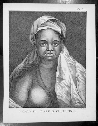
1778 Capt Cook Antique Print Portrait Princess of Tahuata, Marquesas Isles, 1774
- Title : Femme De L Isle de Ste. Christine
- Ref : 31806
- Size: 10in x 8in (255mm x 205mm)
- Date : 1778
- Condition: (A+) Fine Condition
Description:
This fine original copper-plate engraved antique print, a portrait of a Princess of Tahuata Island, Santa Cristina, in the Marquesas Islands, South Pacific, visited by Captain James Cook during his 2nd Voyage of Discovery in the South Seas in 1774, was engraved by Robert Benard - after William Hodges - and was published in the 1778 French edition of Capt. James Cooks 2nd Voyage of Discovery to the South Seas A voyage towards the South Pole, and round the World. Performed in His Majestys ships the Resolution and Adventure, in the years 1772, 1773, 1774, and 1775..... Paris : Hotel de Thou ......1778
Cook Diary (1774)
Apr. 7 Thu. Sights Hood’s Island (Fatu Huku), St. Pedro (Motare). La Dominica (Hiva Oa), St. Christina (Tahuata).
Apr 8 Fri. Sails along southern coast of Hiva Oa looking for anchorage. Anchors in Resolution (formerly Madre de Dios) Bay (Vaitahu Bay). Canoes arrive, gifts are exchanged. Natives killed after an iron stanchion is stolen.
Apr 9 Sat. Goes ashore, gifts exchanged, food obtained.
Apr 10 Sun. Goes ashore to south end of Bay and visits house of dead man. Gifts exchanged.
Apr 11 Mon. Goes ashore to south, again. Finds trade becoming expensive because of lavish gifts by his “gentlemen”.
Apr 12 Tue. Sails towards St. Dominica. No anchorage visible. Heads SW away from islands.
Apr 13 Wed. Sights last of the five main islands, Magdalena (Fatu Hiva).
General Definitions:
Paper thickness and quality: - Heavy and stable
Paper color : - off white
Age of map color: -
Colors used: -
General color appearance: -
Paper size: - 10in x 8in (255mm x 205mm)
Plate size: - 9 1/2in x 7 1/4in (240mm x 185mm)
Margins: - Min 1/2in (12mm)
Imperfections:
Margins: - Light soiling in margins
Plate area: - None
Verso: - None
Background:
Tahuata is the smallest of the inhabited Marquesas Islands, in French Polynesia, an overseas territory of France in the Pacific Ocean.
The first recorded sighting by Europeans was by the Spanish expedition of Álvaro de Mandaña on 22 July 1595. They charted the island as Santa Cristina. They landed at Vaitahu that they named Madre de Dios (Gods Mother in Spanish). According to the Spanish accounts Tahuata had fowls, fish, sugar cane, plantains, nuts and fruits. The existent town was built on two sides of a rectangular space, the houses being of timber and intertwined canes. A building which the Spaniards supposed to be a religious one stood outside the town, in a space enclosed by palisades, and containing some ill-carved images before which were offerings and provisions. The people had large and well constructed sailing canoes. Their tools were made of shells and fish bones. They used slings, stones, and lances as weapons.
Tahuata was visited by Captain James Cook in 1774 and Admiral Dupetit-Thouars in 1842, who signed the treaty annexing the Marquesas Islands to France.
The Marquesas Islands are a group of volcanic islands in French Polynesia, an overseas collective of France in the southern Pacific Ocean.
The first Europeans to reach the Marquesas may have been the crew of San Lesmes, a Spanish vessel which disappeared in a storm in June 1526; it was part of an expedition headed by García Jofre de Loaísa. The Spanish explorer Álvaro de Mendaña reached them seventy years later on 21 July 1595. He named them after his patron, García Hurtado de Mendoza, 5th Marquis of Cañete (Spanish: Marqués de Cañete), who served as Viceroy of Peru from 1590 to 1596. |Mendaña visited first Fatu Hiva and then Tahuata before continuing on to the Solomon Islands. His expedition charted the four southernmost Marquesas as Magdalena (Fatu Hiva), Dominica (Hiva ʻOa), San Pedro (Moho Tani), and Santa Cristina (Tahuata).
In the late 16th century European explorers estimated the population at more than 100,000. Europeans and Americans were impressed with how easy life appeared to be in the islands, which had a rich habitat and environment. In 1791 the American maritime fur trader Joseph Ingraham first visited the northern Marquesas while commanding the brig Hope. He named them the Washington Islands. In 1813 Commodore David Porter claimed Nuku Hiva for the United States, but the United States Congress never ratified that claim.
In 1842 France conducted a successful military operation on behalf of the native chief Iotete, who claimed he was king of the whole island of Tahuata. The government laid claim to the whole group and established a settlement on Nuku Hiva. That settlement was abandoned in 1857, but France re-established control over the group in 1870. It later incorporated the Marquesas into French Polynesia.
William Hodges RA 1744 – 1797 was an English painter. He was a member of James Cooks second voyage to the Pacific Ocean, and is best known for the sketches and paintings of locations he visited on that voyage, including Table Bay, Tahiti, Easter Island, and the Antarctic.
Between 1772 and 1775 Hodges accompanied James Cook to the Pacific as the expeditions artist. Many of his sketches and wash paintings were adapted as engravings in the original published edition of Cooks journals from the voyage.
Most of the large-scale landscape oil paintings from his Pacific travels for which Hodges is best known were finished after his return to London; he received a salary from the Admiralty for the purposes of completing them. These paintings depicted a stronger light and shadow than had been usual in European landscape tradition. Contemporary art critics complained that his use of light and colour contrasts gave his paintings a rough and unfinished appearance.
Hodges also produced many valuable portrait sketches of Pacific islanders and scenes from the voyage involving members of the expedition..
Robert Bénard 1734 – 1777 was an 18th-century French engraver.
Specialized in the technique of engraving, Robert Ménard is mainly famous for having supplied a significant amount of plates (at least 1,800) to the Encyclopédie by Diderot & d\'Alembert from 1751.
Later, publisher Charles-Joseph Panckoucke reused many of his productions to illustrate the works of his catalog.
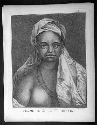
1778 Capt Cook Antique Print Portrait Princess of Tahuata, Marquesas Isles, 1774
- Title : Femme De L Isle de Ste. Christine
- Ref : 16349
- Size: 10in x 8in (255mm x 205mm)
- Date : 1778
- Condition: (A+) Fine Condition
Description:
This fine original copper-plate engraved antique print, a portrait of a Princess of Tahuata Island, Santa Cristina, in the Marquesas Islands, South Pacific, visited by Captain James Cook during his 2nd Voyage of Discovery in the South Seas in 1774, was engraved by Robert Benard - after William Hodges - and was published in the 1778 French edition of Capt. James Cooks 2nd Voyage of Discovery to the South Seas A voyage towards the South Pole, and round the World. Performed in His Majestys ships the Resolution and Adventure, in the years 1772, 1773, 1774, and 1775..... Paris : Hotel de Thou ......1778
Cook Diary (1774)
Apr. 7 Thu. Sights Hood’s Island (Fatu Huku), St. Pedro (Motare). La Dominica (Hiva Oa), St. Christina (Tahuata).
Apr 8 Fri. Sails along southern coast of Hiva Oa looking for anchorage. Anchors in Resolution (formerly Madre de Dios) Bay (Vaitahu Bay). Canoes arrive, gifts are exchanged. Natives killed after an iron stanchion is stolen.
Apr 9 Sat. Goes ashore, gifts exchanged, food obtained.
Apr 10 Sun. Goes ashore to south end of Bay and visits house of dead man. Gifts exchanged.
Apr 11 Mon. Goes ashore to south, again. Finds trade becoming expensive because of lavish gifts by his “gentlemen”.
Apr 12 Tue. Sails towards St. Dominica. No anchorage visible. Heads SW away from islands.
Apr 13 Wed. Sights last of the five main islands, Magdalena (Fatu Hiva).
General Definitions:
Paper thickness and quality: - Heavy and stable
Paper color : - off white
Age of map color: -
Colors used: -
General color appearance: -
Paper size: - 10in x 8in (255mm x 205mm)
Plate size: - 9 1/2in x 7 1/4in (240mm x 185mm)
Margins: - Min 1/2in (12mm)
Imperfections:
Margins: - Light soiling in margins
Plate area: - None
Verso: - None
Background:
Tahuata is the smallest of the inhabited Marquesas Islands, in French Polynesia, an overseas territory of France in the Pacific Ocean.
The first recorded sighting by Europeans was by the Spanish expedition of Álvaro de Mandaña on 22 July 1595. They charted the island as Santa Cristina. They landed at Vaitahu that they named Madre de Dios (Gods Mother in Spanish). According to the Spanish accounts Tahuata had fowls, fish, sugar cane, plantains, nuts and fruits. The existent town was built on two sides of a rectangular space, the houses being of timber and intertwined canes. A building which the Spaniards supposed to be a religious one stood outside the town, in a space enclosed by palisades, and containing some ill-carved images before which were offerings and provisions. The people had large and well constructed sailing canoes. Their tools were made of shells and fish bones. They used slings, stones, and lances as weapons.
Tahuata was visited by Captain James Cook in 1774 and Admiral Dupetit-Thouars in 1842, who signed the treaty annexing the Marquesas Islands to France.
The Marquesas Islands are a group of volcanic islands in French Polynesia, an overseas collective of France in the southern Pacific Ocean.
The first Europeans to reach the Marquesas may have been the crew of San Lesmes, a Spanish vessel which disappeared in a storm in June 1526; it was part of an expedition headed by García Jofre de Loaísa. The Spanish explorer Álvaro de Mendaña reached them seventy years later on 21 July 1595. He named them after his patron, García Hurtado de Mendoza, 5th Marquis of Cañete (Spanish: Marqués de Cañete), who served as Viceroy of Peru from 1590 to 1596. |Mendaña visited first Fatu Hiva and then Tahuata before continuing on to the Solomon Islands. His expedition charted the four southernmost Marquesas as Magdalena (Fatu Hiva), Dominica (Hiva ʻOa), San Pedro (Moho Tani), and Santa Cristina (Tahuata).
In the late 16th century European explorers estimated the population at more than 100,000. Europeans and Americans were impressed with how easy life appeared to be in the islands, which had a rich habitat and environment. In 1791 the American maritime fur trader Joseph Ingraham first visited the northern Marquesas while commanding the brig Hope. He named them the Washington Islands. In 1813 Commodore David Porter claimed Nuku Hiva for the United States, but the United States Congress never ratified that claim.
In 1842 France conducted a successful military operation on behalf of the native chief Iotete, who claimed he was king of the whole island of Tahuata. The government laid claim to the whole group and established a settlement on Nuku Hiva. That settlement was abandoned in 1857, but France re-established control over the group in 1870. It later incorporated the Marquesas into French Polynesia.
William Hodges RA 1744 – 1797 was an English painter. He was a member of James Cooks second voyage to the Pacific Ocean, and is best known for the sketches and paintings of locations he visited on that voyage, including Table Bay, Tahiti, Easter Island, and the Antarctic.
Between 1772 and 1775 Hodges accompanied James Cook to the Pacific as the expeditions artist. Many of his sketches and wash paintings were adapted as engravings in the original published edition of Cooks journals from the voyage.
Most of the large-scale landscape oil paintings from his Pacific travels for which Hodges is best known were finished after his return to London; he received a salary from the Admiralty for the purposes of completing them. These paintings depicted a stronger light and shadow than had been usual in European landscape tradition. Contemporary art critics complained that his use of light and colour contrasts gave his paintings a rough and unfinished appearance.
Hodges also produced many valuable portrait sketches of Pacific islanders and scenes from the voyage involving members of the expedition..
Robert Bénard 1734 – 1777 was an 18th-century French engraver.
Specialized in the technique of engraving, Robert Ménard is mainly famous for having supplied a significant amount of plates (at least 1,800) to the Encyclopédie by Diderot & d\'Alembert from 1751.
Later, publisher Charles-Joseph Panckoucke reused many of his productions to illustrate the works of his catalog.
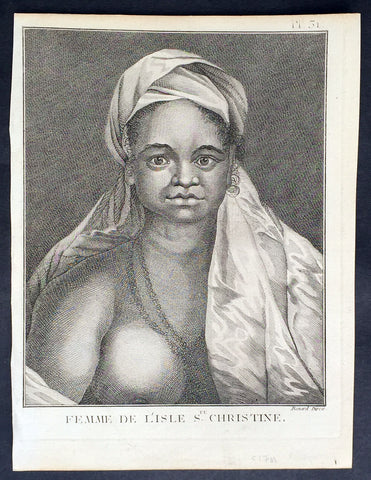
1778 Capt Cook Antique Print Portrait Princess of Tahuata, Marquesas Isles, 1774
- Title : Femme De L Isle de Ste. Christine
- Ref : 21399
- Size: 10in x 8in (255mm x 205mm)
- Date : 1778
- Condition: (A+) Fine Condition
Description:
This fine original copper-plate engraved antique print, a portrait of a Princess of Tahuata Island, Santa Cristina, in the Marquesas Islands, South Pacific, visited by Captain James Cook during his 2nd Voyage of Discovery in the South Seas in 1774, was engraved by Robert Benard - after William Hodges - and was published in the 1778 French edition of Capt. James Cooks 2nd Voyage of Discovery to the South Seas A voyage towards the South Pole, and round the World. Performed in His Majestys ships the Resolution and Adventure, in the years 1772, 1773, 1774, and 1775..... Paris : Hotel de Thou ......1778
Cook Diary (1774)
Apr. 7 Thu. Sights Hood’s Island (Fatu Huku), St. Pedro (Motare). La Dominica (Hiva Oa), St. Christina (Tahuata).
Apr 8 Fri. Sails along southern coast of Hiva Oa looking for anchorage. Anchors in Resolution (formerly Madre de Dios) Bay (Vaitahu Bay). Canoes arrive, gifts are exchanged. Natives killed after an iron stanchion is stolen.
Apr 9 Sat. Goes ashore, gifts exchanged, food obtained.
Apr 10 Sun. Goes ashore to south end of Bay and visits house of dead man. Gifts exchanged.
Apr 11 Mon. Goes ashore to south, again. Finds trade becoming expensive because of lavish gifts by his “gentlemen”.
Apr 12 Tue. Sails towards St. Dominica. No anchorage visible. Heads SW away from islands.
Apr 13 Wed. Sights last of the five main islands, Magdalena (Fatu Hiva).
General Definitions:
Paper thickness and quality: - Heavy and stable
Paper color : - off white
Age of map color: -
Colors used: -
General color appearance: -
Paper size: - 10in x 8in (255mm x 205mm)
Plate size: - 9 1/2in x 7 1/4in (240mm x 185mm)
Margins: - Min 1/2in (12mm)
Imperfections:
Margins: - Light soiling in margins
Plate area: - None
Verso: - None
Background:
Tahuata is the smallest of the inhabited Marquesas Islands, in French Polynesia, an overseas territory of France in the Pacific Ocean.
The first recorded sighting by Europeans was by the Spanish expedition of Álvaro de Mandaña on 22 July 1595. They charted the island as Santa Cristina. They landed at Vaitahu that they named Madre de Dios (Gods Mother in Spanish). According to the Spanish accounts Tahuata had fowls, fish, sugar cane, plantains, nuts and fruits. The existent town was built on two sides of a rectangular space, the houses being of timber and intertwined canes. A building which the Spaniards supposed to be a religious one stood outside the town, in a space enclosed by palisades, and containing some ill-carved images before which were offerings and provisions. The people had large and well constructed sailing canoes. Their tools were made of shells and fish bones. They used slings, stones, and lances as weapons.
Tahuata was visited by Captain James Cook in 1774 and Admiral Dupetit-Thouars in 1842, who signed the treaty annexing the Marquesas Islands to France.
The Marquesas Islands are a group of volcanic islands in French Polynesia, an overseas collective of France in the southern Pacific Ocean.
The first Europeans to reach the Marquesas may have been the crew of San Lesmes, a Spanish vessel which disappeared in a storm in June 1526; it was part of an expedition headed by García Jofre de Loaísa. The Spanish explorer Álvaro de Mendaña reached them seventy years later on 21 July 1595. He named them after his patron, García Hurtado de Mendoza, 5th Marquis of Cañete (Spanish: Marqués de Cañete), who served as Viceroy of Peru from 1590 to 1596. |Mendaña visited first Fatu Hiva and then Tahuata before continuing on to the Solomon Islands. His expedition charted the four southernmost Marquesas as Magdalena (Fatu Hiva), Dominica (Hiva ʻOa), San Pedro (Moho Tani), and Santa Cristina (Tahuata).
In the late 16th century European explorers estimated the population at more than 100,000. Europeans and Americans were impressed with how easy life appeared to be in the islands, which had a rich habitat and environment. In 1791 the American maritime fur trader Joseph Ingraham first visited the northern Marquesas while commanding the brig Hope. He named them the Washington Islands. In 1813 Commodore David Porter claimed Nuku Hiva for the United States, but the United States Congress never ratified that claim.
In 1842 France conducted a successful military operation on behalf of the native chief Iotete, who claimed he was king of the whole island of Tahuata. The government laid claim to the whole group and established a settlement on Nuku Hiva. That settlement was abandoned in 1857, but France re-established control over the group in 1870. It later incorporated the Marquesas into French Polynesia.
William Hodges RA 1744 – 1797 was an English painter. He was a member of James Cooks second voyage to the Pacific Ocean, and is best known for the sketches and paintings of locations he visited on that voyage, including Table Bay, Tahiti, Easter Island, and the Antarctic.
Between 1772 and 1775 Hodges accompanied James Cook to the Pacific as the expeditions artist. Many of his sketches and wash paintings were adapted as engravings in the original published edition of Cooks journals from the voyage.
Most of the large-scale landscape oil paintings from his Pacific travels for which Hodges is best known were finished after his return to London; he received a salary from the Admiralty for the purposes of completing them. These paintings depicted a stronger light and shadow than had been usual in European landscape tradition. Contemporary art critics complained that his use of light and colour contrasts gave his paintings a rough and unfinished appearance.
Hodges also produced many valuable portrait sketches of Pacific islanders and scenes from the voyage involving members of the expedition..
Robert Bénard 1734 – 1777 was an 18th-century French engraver.
Specialized in the technique of engraving, Robert Ménard is mainly famous for having supplied a significant amount of plates (at least 1,800) to the Encyclopédie by Diderot & d\'Alembert from 1751.
Later, publisher Charles-Joseph Panckoucke reused many of his productions to illustrate the works of his catalog.
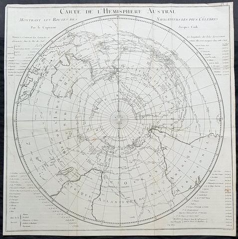
1778 Capt James Cook Antique Map The Southern Hemisphere, Australia, Antarctica
- Title : Carte De L Hemisphere Austral Montrant les Routes des Navigateurs les plus Celebree par le Capitaine Jacques Cook
- Ref : 42004
- Size: 22in x 21 1/2in (560mm x 545mm)
- Date : 1778
- Condition: (A) Very Good Condition
Description:
This fine original copper-plate engraved, antique map, a chart of the Southern Hemisphere, was engraved by Robert Benard and is dedicated to the discoveries in the South Seas and Antarctic Regions of Captain James Cook during his second Voyage of Discovery between 1772 & 1775. By comparison the tracks of 11 other explorers are included, from the 16th to the 18th centuries. The map by Captain James Cook was published in the 1778 French edition of A voyage towards the South Pole, and round the World. Performed in His Majestys ships the Resolution and Adventure, in the years 1772, 1773, 1774, and 1775..... Paris : Hotel de Thou ......1778
This map is unique in another way, as the English edition of this map was used as a prop, by Nathaniel Dance, in his 1776 portrait of Captain James Cook. Please also see above for the portrait.
The 11 other explorers and their tracks around the Southern Hemisphere are;
1. Mendana in 1595
2. Quiros in 1606
3. Le Maire & Schouten in 1616
4. Tasman in 1642
5. Halley in 1700
6. Roggewein in 1722
7. Bouvet in 1738-39
8. Byron in 1765
9. Wallis in 1767
10. Bougainville in 1768
11. Surville in 1769
12. Cooks first and second voyages.
General Definitions:
Paper thickness and quality: - Heavy and stable
Paper color : - off white
Age of map color: -
Colors used: -
General color appearance: -
Paper size: - 22in x 21 1/2in (560mm x 545mm)
Plate size: - 22in x 21 1/2in (560mm x 545mm)
Margins: - Min 1/2in (12mm)
Imperfections:
Margins: - Repair without loss to left of image
Plate area: - Folds as issued, light creasing along folds
Verso: - Folds as issued, light creasing along folds
Background:
This map by James Cook, was published as the premier map of his second voyage to the Southern Hemisphere, dispelling forever the myth of the Great Southern Land and showing the true cartographic nature of the southern hemisphere dominated by Australia & New Zealand. The map on a South Polar Projection also shows South America, the South Atlantic Ocean, South Africa, Madagascar, Australia - with Tasmania still joined to the mainland - New Zealand and the southern Pacific Ocean with islands.
Engraved within the explorer\\\'s tracks are the dates of their voyages and ships tracks are particularly noted around the Antarctic Circle with notations of ice fields seen during the voyages.
John Hawkesworth An English writer and journalist, Hawkesworth was commissioned by the British Admiralty to edit for publication the narratives of its officers’ circumnavigations. He was given full access to the journals of the commanders and the freedom to adapt and re-tell them in the first person. Cook was already on his way back from his second Pacific voyage, temporarily docked at Cape Town (South Africa), when he first saw the published volumes: he was mortified and furious to find that Hawkesworth claimed in the introduction that Cook had seen and blessed (with slight corrections) the resulting manuscript. (In his defense, Hawkesworth also had been a victim of misunderstanding.) Cook had trouble recognizing himself. Moreover, the work was full of errors and commentary introduced by Hawkesworth and, in Cook’s view, too full of Banks, who had promoted himself and the publication. Still, the work was popular; the first edition sold out in several months.
Robert Bénard 1734 – 1777 was an 18th-century French engraver.
Specialized in the technique of engraving, Robert Ménard is mainly famous for having supplied a significant amount of plates (at least 1,800) to the Encyclopédie by Diderot & d Alembert from 1751.
Later, publisher Charles-Joseph Panckoucke reused many of his productions to illustrate the works of his catalog.
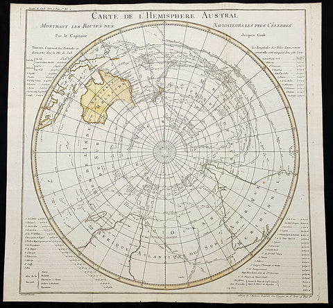
1778 Capt James Cook Antique Map The Southern Hemisphere, Australia, Antarctica
- Title : Carte De L Hemisphere Austral Montrant les Routes des Navigateurs les plus Celebree par le Capitaine Jacques Cook
- Ref : 93354
- Size: 22in x 21 1/2in (560mm x 545mm)
- Date : 1778
- Condition: (A+) Fine Condition
Description:
This fine original copper-plate engraved, hand coloured antique map, a chart of the Southern Hemisphere, was engraved by Robert Benard and is dedicated to the discoveries in the South Seas and Antarctic Regions of Captain James Cook during his second Voyage of Discovery between 1772 & 1775. By comparison the tracks of 11 other explorers are included, from the 16th to the 18th centuries. The map by Captain James Cook was published in the 1778 French edition of A voyage towards the South Pole, and round the World. Performed in His Majestys ships the Resolution and Adventure, in the years 1772, 1773, 1774, and 1775..... Paris : Hotel de Thou ......1778
This map is unique in another way, as the English edition of this map was used as a prop, by Nathaniel Dance, in his 1776 portrait of Captain James Cook. Please also see above for the portrait.
The 11 other explorers and their tracks around the Southern Hemisphere are;
1. Mendana in 1595
2. Quiros in 1606
3. Le Maire & Schouten in 1616
4. Tasman in 1642
5. Halley in 1700
6. Roggewein in 1722
7. Bouvet in 1738-39
8. Byron in 1765
9. Wallis in 1767
10. Bougainville in 1768
11. Surville in 1769
12. Cooks first and second voyages.
General Definitions:
Paper thickness and quality: - Heavy and stable
Paper color : - off white
Age of map color: - Early
Colors used: - Yellow
General color appearance: - Authentic
Paper size: - 22in x 21 1/2in (560mm x 545mm)
Plate size: - 22in x 21 1/2in (560mm x 545mm)
Margins: - Min 1/2in (12mm)
Imperfections:
Margins: - Folds as issued
Plate area: - Folds as issued.
Verso: - Folds as issued.
Background:
This map by James Cook, was published as the premier map of his second voyage to the Southern Hemisphere, dispelling forever the myth of the Great Southern Land and showing the true cartographic nature of the southern hemisphere dominated by Australia & New Zealand. The map on a South Polar Projection also shows South America, the South Atlantic Ocean, South Africa, Madagascar, Australia - with Tasmania still joined to the mainland - New Zealand and the southern Pacific Ocean with islands.
Engraved within the explorer\\\'s tracks are the dates of their voyages and ships tracks are particularly noted around the Antarctic Circle with notations of ice fields seen during the voyages.
John Hawkesworth An English writer and journalist, Hawkesworth was commissioned by the British Admiralty to edit for publication the narratives of its officers’ circumnavigations. He was given full access to the journals of the commanders and the freedom to adapt and re-tell them in the first person. Cook was already on his way back from his second Pacific voyage, temporarily docked at Cape Town (South Africa), when he first saw the published volumes: he was mortified and furious to find that Hawkesworth claimed in the introduction that Cook had seen and blessed (with slight corrections) the resulting manuscript. (In his defense, Hawkesworth also had been a victim of misunderstanding.) Cook had trouble recognizing himself. Moreover, the work was full of errors and commentary introduced by Hawkesworth and, in Cook’s view, too full of Banks, who had promoted himself and the publication. Still, the work was popular; the first edition sold out in several months.
Robert Bénard 1734 – 1777 was an 18th-century French engraver.
Specialized in the technique of engraving, Robert Ménard is mainly famous for having supplied a significant amount of plates (at least 1,800) to the Encyclopédie by Diderot & d Alembert from 1751.
Later, publisher Charles-Joseph Panckoucke reused many of his productions to illustrate the works of his catalog.
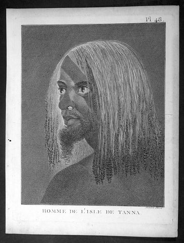
1778 Capt. Cook Antique Print of a Man of the Tanna Island, Vanuatu in 1774
- Title : Homme De L Isle de Tanna
- Ref : 16344-1
- Size: 10in x 8in (255mm x 205mm)
- Date : 1778
- Condition: (A+) Fine Condition
Description:
This fine original copper-plate engraved antique print, a portrait of a Man of the Island of Tanna in the Vanuatu group of Islands in the South Pacific, visited by Captain James Cook during his 2nd Voyage of Discovery in the South Seas in 1774, was engraved by Robert Benard - after William Hodges - and was published in the 1778 French edition of Capt. James Cooks 2nd Voyage of Discovery to the South Seas A voyage towards the South Pole, and round the World. Performed in His Majestys ships the Resolution and Adventure, in the years 1772, 1773, 1774, and 1775..... Paris : Hotel de Thou ......1778
Cook Diary, 6-20th August 1774
........the Women have all the same ornaments as Men, Nose-Stones, Earrings, Shells on the Breast & Bracelets...their heads covered with a kind of cap made of a Plantain leaf or a Mat-Basket. Few are covered, & even very young Girls have these Caps.......Cooks Journal II
General Definitions:
Paper thickness and quality: - Heavy and stable
Paper color : - off white
Age of map color: -
Colors used: -
General color appearance: -
Paper size: - 10in x 8in (255mm x 205mm)
Plate size: - 9 1/2in x 7 1/4in (240mm x 185mm)
Margins: - Min 1/2in (12mm)
Imperfections:
Margins: - Light soiling in margins
Plate area: - None
Verso: - None
Background:
Tanna (sometimes spelled Tana) is an island in Tafea Province of Vanuatu.
Tanna was first settled about 400 BC by Melanesians from the surrounding islands. The glowing light of Mount Yasur attracted James Cook, the first European to visit the island, in August 1774, where he landed in an inlet on the southeastern tip of the island that he named Port Resolution after his ship HMS Resolution. He gave the island the name of Tanna, probably from the local name for earth, tana in the Kwamera language.
Vanuatu is a Pacific island nation located in the South Pacific Ocean. The archipelago, which is of volcanic origin, is 1,750 kilometres east of northern Australia, 540 kilometres northeast of New Caledonia, east of New Guinea, southeast of the Solomon Islands, and west of Fiji.
The Vanuatu group of islands first had contact with Europeans in 1606, when the Portuguese explorer Pedro Fernandes de Queirós, sailing for the Spanish Crown, arrived on the largest island and called the group of islands La Austrialia del Espiritu Santo or The Southern Land of the Holy Spirit, believing he had arrived in Terra Australis or Australia. The Spanish established a short-lived settlement at Big Bay on the north side of the island. The name Espiritu Santo remains to this day.
Europeans did not return until 1768, when Louis Antoine de Bougainville rediscovered the islands on 22 May, naming them the Great Cyclades. In 1774, Captain Cook named the islands the New Hebrides, a name that would last until independence in 1980.
William Hodges RA 1744 – 1797 was an English painter. He was a member of James Cooks second voyage to the Pacific Ocean, and is best known for the sketches and paintings of locations he visited on that voyage, including Table Bay, Tahiti, Easter Island, and the Antarctic.
Between 1772 and 1775 Hodges accompanied James Cook to the Pacific as the expeditions artist. Many of his sketches and wash paintings were adapted as engravings in the original published edition of Cooks journals from the voyage.
Most of the large-scale landscape oil paintings from his Pacific travels for which Hodges is best known were finished after his return to London; he received a salary from the Admiralty for the purposes of completing them. These paintings depicted a stronger light and shadow than had been usual in European landscape tradition. Contemporary art critics complained that his use of light and colour contrasts gave his paintings a rough and unfinished appearance.
Hodges also produced many valuable portrait sketches of Pacific islanders and scenes from the voyage involving members of the expedition..
Robert Bénard 1734 – 1777 was an 18th-century French engraver.
Specialized in the technique of engraving, Robert Ménard is mainly famous for having supplied a significant amount of plates (at least 1,800) to the Encyclopédie by Diderot & d\'Alembert from 1751.
Later, publisher Charles-Joseph Panckoucke reused many of his productions to illustrate the works of his catalog.
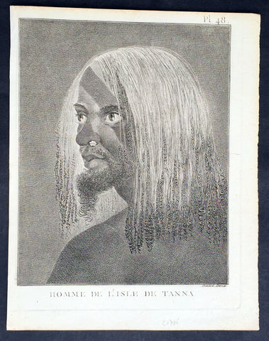
1778 Capt. Cook Antique Print of a Man of the Tanna Island, Vanuatu in 1774
- Title : Homme De L Isle de Tanna
- Ref : 21353
- Size: 10in x 8in (255mm x 205mm)
- Date : 1778
- Condition: (A+) Fine Condition
Description:
This fine original copper-plate engraved antique print, a portrait of a Man of the Island of Tanna in the Vanuatu group of Islands in the South Pacific, visited by Captain James Cook during his 2nd Voyage of Discovery in the South Seas in 1774, was engraved by Robert Benard - after William Hodges - and was published in the 1778 French edition of Capt. James Cooks 2nd Voyage of Discovery to the South Seas A voyage towards the South Pole, and round the World. Performed in His Majestys ships the Resolution and Adventure, in the years 1772, 1773, 1774, and 1775..... Paris : Hotel de Thou ......1778
Cook Diary, 6-20th August 1774
........the Women have all the same ornaments as Men, Nose-Stones, Earrings, Shells on the Breast & Bracelets...their heads covered with a kind of cap made of a Plantain leaf or a Mat-Basket. Few are covered, & even very young Girls have these Caps.......Cooks Journal II
General Definitions:
Paper thickness and quality: - Heavy and stable
Paper color : - off white
Age of map color: -
Colors used: -
General color appearance: -
Paper size: - 10in x 8in (255mm x 205mm)
Plate size: - 9 1/2in x 7 1/4in (240mm x 185mm)
Margins: - Min 1/2in (12mm)
Imperfections:
Margins: - Light soiling in margins
Plate area: - None
Verso: - None
Background:
Tanna (sometimes spelled Tana) is an island in Tafea Province of Vanuatu.
Tanna was first settled about 400 BC by Melanesians from the surrounding islands. The glowing light of Mount Yasur attracted James Cook, the first European to visit the island, in August 1774, where he landed in an inlet on the southeastern tip of the island that he named Port Resolution after his ship HMS Resolution. He gave the island the name of Tanna, probably from the local name for earth, tana in the Kwamera language.
Vanuatu is a Pacific island nation located in the South Pacific Ocean. The archipelago, which is of volcanic origin, is 1,750 kilometres east of northern Australia, 540 kilometres northeast of New Caledonia, east of New Guinea, southeast of the Solomon Islands, and west of Fiji.
The Vanuatu group of islands first had contact with Europeans in 1606, when the Portuguese explorer Pedro Fernandes de Queirós, sailing for the Spanish Crown, arrived on the largest island and called the group of islands La Austrialia del Espiritu Santo or The Southern Land of the Holy Spirit, believing he had arrived in Terra Australis or Australia. The Spanish established a short-lived settlement at Big Bay on the north side of the island. The name Espiritu Santo remains to this day.
Europeans did not return until 1768, when Louis Antoine de Bougainville rediscovered the islands on 22 May, naming them the Great Cyclades. In 1774, Captain Cook named the islands the New Hebrides, a name that would last until independence in 1980.
William Hodges RA 1744 – 1797 was an English painter. He was a member of James Cooks second voyage to the Pacific Ocean, and is best known for the sketches and paintings of locations he visited on that voyage, including Table Bay, Tahiti, Easter Island, and the Antarctic.
Between 1772 and 1775 Hodges accompanied James Cook to the Pacific as the expeditions artist. Many of his sketches and wash paintings were adapted as engravings in the original published edition of Cooks journals from the voyage.
Most of the large-scale landscape oil paintings from his Pacific travels for which Hodges is best known were finished after his return to London; he received a salary from the Admiralty for the purposes of completing them. These paintings depicted a stronger light and shadow than had been usual in European landscape tradition. Contemporary art critics complained that his use of light and colour contrasts gave his paintings a rough and unfinished appearance.
Hodges also produced many valuable portrait sketches of Pacific islanders and scenes from the voyage involving members of the expedition..
Robert Bénard 1734 – 1777 was an 18th-century French engraver.
Specialized in the technique of engraving, Robert Ménard is mainly famous for having supplied a significant amount of plates (at least 1,800) to the Encyclopédie by Diderot & d\'Alembert from 1751.
Later, publisher Charles-Joseph Panckoucke reused many of his productions to illustrate the works of his catalog.
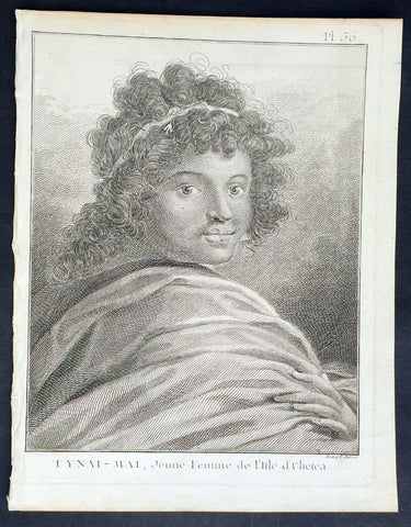
1778 Capt. Cook Antique Print of Princess Tynai-Mai of Raiatea Island in 1773
- Title : Tynai-Mai, Jeune Femme de L Isle d Ulietea
- Ref : 21319
- Size: 10in x 8in (255mm x 205mm)
- Date : 1778
- Condition: (A+) Fine Condition
Description:
This fine original copper-plate engraved antique print, a portrait of Princess Tynai-Mai of Raiatea (Ulietea) Island, the second largest of the Society Islands, after Tahiti, in French Polynesia, met by Captain James Cook during his 2nd Voyage of Discovery in 1773, was engraved by Robert Benard - after William Hodges - and was published in the 1778 French edition of Capt. James Cooks 2nd Voyage of Discovery to the South Seas A voyage towards the South Pole, and round the World. Performed in His Majestys ships the Resolution and Adventure, in the years 1772, 1773, 1774, and 1775..... Paris : Hotel de Thou ......1778
General Definitions:
Paper thickness and quality: - Heavy and stable
Paper color : - off white
Age of map color: -
Colors used: -
General color appearance: -
Paper size: - 10in x 8in (255mm x 205mm)
Plate size: - 9 1/2in x 7 1/4in (240mm x 185mm)
Margins: - Min 1/2in (12mm)
Imperfections:
Margins: - Light soiling in margins
Plate area: - None
Verso: - None
Background:
Raiatea, is the second largest of the Society Islands, after Tahiti, in French Polynesia. The island is widely regarded as the centre of the eastern islands in ancient Polynesia and it is likely that the organised migrations to Hawaii, Aotearoa and other parts of East Polynesia started at Raiātea.
A traditional name for the island is Havaii, homeland of the Māori people.
The first European to record sighting Ra iātea was Pedro Fernandes de Queirós in 1606; it was charted as La Fugitiva The Polynesian navigator, Tupaia, who sailed with explorer James Cook, was born in Raiātea around 1725.
Cook visited Raiatea in 1769 and again in 1773-1774. Omai (c.1751-1780), another young man from Raiātea, traveled with the European explorers to London in 1774 and also served as an interpreter to Captain Cook on his second and third journey.
King Tamatoa VI was the last monarch, reigning from 1884-1888.
Tahiti previously also known as Otaheite is the largest island in the Windward group of French Polynesia. The island is located in the archipelago of the Society Islands in the central Southern Pacific Ocean.
The first European to have visited Tahiti according to existing records was lieutenant Samuel Wallis, who was circumnavigating the globe in HMS Dolphin, sighting the island on 18 June 1767, and eventually harboring in Matavai Bay. This bay was situated on the territory of the chiefdom of Pare-Arue, governed by Tu (Tu-nui-e-a a-i-te-Atua) and his regent Tutaha, and the chiefdom of Ha apape, governed by Amo and his wife Oberea (Purea). Wallis named the island King Georges Island. The first contacts were difficult, since on the 24 and 26 June 1767, Tahitian warriors in canoes showed aggression towards the British, hurling stones from their slings. In retaliation, the British sailors opened fire on the warriors in the canoes and on the hills. In reaction to this powerful counter-attack, the Tahitians laid down peace offerings for the British. Following this episode, Samuel Wallis was able to establish cordial relations with the female chieftain “Oberea “ (Purea) and remained on the island until 27 July 1767.
In July 1768, Captain James Cook was commissioned by the Royal Society and on orders from the Lords Commissioners of the Admiralty to observe the transit of Venus across the sun, a phenomenon that would be visible from Tahiti on 3 June 1769. He arrived in Tahitis Matavai Bay, commanding the HMS Endeavour on 12 April 1769. On 14 April, Cook met with Tutaha and Tepau. On 15 April, Cook picked the site for a fortified camp at Point Venus along with Banks, Parkinson, Daniel Solander, to protect Charles Greens observatory. The length of stay enabled them to undertake for the first time real ethnographic and scientific observations of the island. Assisted by the botanist Joseph Banks, and by the artist Sydney Parkinson, Cook gathered valuable information on the fauna and flora, as well as the native society, language and customs, including the proper name of the island, Otaheite. On 28 April, Cook met Purea and Tupaia, and Tupaia befriended Banks following the transit. On 21 June, Amo visited Cook, and then on 25 June, Pohuetea visited, signifying another chief seeking to ally himself with the British.
Cook and Banks circumnavigated the island from 26 June to 1 July. On the exploration, they met Ahio, chief of Ha apaiano o or Papenoo, Rita, chief of Hitia a, Pahairro, chief of Pueu, Vehiatua, chief of Tautra, Matahiapo, chief of Teahupo o, Tutea, chief of Vaira o, and Moe, chief of Afa Ahiti. In Papara, guided by Tupaia, they investigated the ruins of Mahaiatea marae, an impressive structure containing a stone pyramid or ahu, measuring 44 feet high, 267 feet long and 87 feet wide. Cook and the Endeavour departed Tahiti on 13 July 1769, taking Raiatean navigator Tupaia along for his geographic knowledge of the islands.
Cook returned to Tahiti between 15 August and 1 September 1773, greeted by the chiefs Tai and Puhi, besides the youg ari i Vehiatua II and his stepfather Ti itorea. Cook anchored in Vaitepiha Bay before returning to Point Venus where he met Tu, the paramount chief. Cook picked up two passengers from Tahiti during this trip, Porea and Mai, with Hitihiti later replacing Porea when Cook stopped at Raiatea. Cook took Hitihiti to Tahiti on 22 April, during his return leg. Then, Cook departed Tahiti on 14 May 1774.
During his final visit, Cook returned Mai to Tahiti on 12 Aug. 1777, after Mais long visit in England. Cook also brought two Maori from Queen Charlotte Sound, Te Weherua and Koa. Cook first harbored in Vaitepiha Bay, where he visited Vehiatua II s funeral bier and the prefabricated Spanish mission house. Cook also met Vehiatua III, and inscribed on the back of the Spanish cross, Georgius tertius Rex Annis 1767, 69, 73, 74 & 77, as a counterpoint to Christus Vincit Carolus III imperat 1774 on the front. On 23 Aug., Cook sailed for Matavai Bay, where he met Tu, his father Teu, his mother Tetupaia, his brothers Ari ipaea and Vaetua, and his sisters Ari ipaea-vahine, Tetua-te-ahamai, and Auo. Cook also observed a human sacrifice, taata tapu, at the Utu-ai-mahurau marae, and 49 skulls from previous victims.
On 29 Sept. 1777, Cook sailed for Papetoai Bay on Moorea. Cook met Mahine in an act of friendship on 3 Oct., though he was an enemy of Tu. When a goat kid was stolen on 6 Oct., Cook in a rampage, ordered the burning of houses and canoes until it was returned. Cook sailed for Huahine on 11 Oct., Raiatea on 2 Nov., and Borabora on 7 Dec.
On 26 October 1788, HMS Bounty, under the command of Captain William Bligh, landed in Tahiti with the mission of carrying Tahitian breadfruit trees (Tahitian: uru) to the Caribbean. Sir Joseph Banks, the botanist from James Cooks first expedition, had concluded that this plant would be ideal to feed the African slaves working in the Caribbean plantations at very little cost. The crew remained in Tahiti for about five months, the time needed to transplant the seedlings of the trees. Three weeks after leaving Tahiti, on 28 April 1789, the crew mutinied on the initiative of Fletcher Christian. The mutineers seized the ship and set the captain and most of those members of the crew who remained loyal to him adrift in a ships boat. A group of mutineers then went back to settle in Tahiti.
Although various explorers had refused to get involved in tribal conflicts, the mutineers from the Bounty offered their services as mercenaries and furnished arms to the family which became the Pōmare Dynasty. The chief Tū knew how to use their presence in the harbours favoured by sailors to his advantage. As a result of his alliance with the mutineers, he succeeded in considerably increasing his supremacy over the island of Tahiti.
William Hodges RA 1744 – 1797 was an English painter. He was a member of James Cooks second voyage to the Pacific Ocean, and is best known for the sketches and paintings of locations he visited on that voyage, including Table Bay, Tahiti, Easter Island, and the Antarctic.
Between 1772 and 1775 Hodges accompanied James Cook to the Pacific as the expeditions artist. Many of his sketches and wash paintings were adapted as engravings in the original published edition of Cooks journals from the voyage.
Most of the large-scale landscape oil paintings from his Pacific travels for which Hodges is best known were finished after his return to London; he received a salary from the Admiralty for the purposes of completing them. These paintings depicted a stronger light and shadow than had been usual in European landscape tradition. Contemporary art critics complained that his use of light and colour contrasts gave his paintings a rough and unfinished appearance.
Hodges also produced many valuable portrait sketches of Pacific islanders and scenes from the voyage involving members of the expedition..
Robert Bénard 1734 – 1777 was an 18th-century French engraver.
Specialized in the technique of engraving, Robert Ménard is mainly famous for having supplied a significant amount of plates (at least 1,800) to the Encyclopédie by Diderot & d\'Alembert from 1751.
Later, publisher Charles-Joseph Panckoucke reused many of his productions to illustrate the works of his catalog.
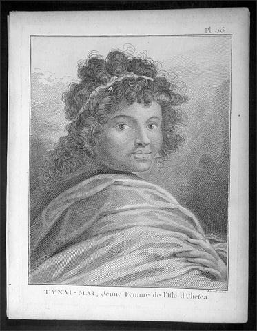
1778 Capt. Cook Antique Print of Princess Tynai-Mai of Raiatea Island in 1773
- Title : Tynai-Mai, Jeune Femme de L Isle d Ulietea
- Ref : 16357
- Size: 10in x 8in (255mm x 205mm)
- Date : 1778
- Condition: (A+) Fine Condition
Description:
This fine original copper-plate engraved antique print, a portrait of Princess Tynai-Mai of Raiatea (Ulietea) Island, the second largest of the Society Islands, after Tahiti, in French Polynesia, met by Captain James Cook during his 2nd Voyage of Discovery in 1773, was engraved by Robert Benard - after William Hodges - and was published in the 1778 French edition of Capt. James Cooks 2nd Voyage of Discovery to the South Seas A voyage towards the South Pole, and round the World. Performed in His Majestys ships the Resolution and Adventure, in the years 1772, 1773, 1774, and 1775..... Paris : Hotel de Thou ......1778
General Definitions:
Paper thickness and quality: - Heavy and stable
Paper color : - off white
Age of map color: -
Colors used: -
General color appearance: -
Paper size: - 10in x 8in (255mm x 205mm)
Plate size: - 9 1/2in x 7 1/4in (240mm x 185mm)
Margins: - Min 1/2in (12mm)
Imperfections:
Margins: - Light soiling in margins
Plate area: - None
Verso: - None
Background:
Raiatea, is the second largest of the Society Islands, after Tahiti, in French Polynesia. The island is widely regarded as the centre of the eastern islands in ancient Polynesia and it is likely that the organised migrations to Hawaii, Aotearoa and other parts of East Polynesia started at Raiātea.
A traditional name for the island is Havaii, homeland of the Māori people.
The first European to record sighting Ra iātea was Pedro Fernandes de Queirós in 1606; it was charted as La Fugitiva The Polynesian navigator, Tupaia, who sailed with explorer James Cook, was born in Raiātea around 1725.
Cook visited Raiatea in 1769 and again in 1773-1774. Omai (c.1751-1780), another young man from Raiātea, traveled with the European explorers to London in 1774 and also served as an interpreter to Captain Cook on his second and third journey.
King Tamatoa VI was the last monarch, reigning from 1884-1888.
Tahiti previously also known as Otaheite is the largest island in the Windward group of French Polynesia. The island is located in the archipelago of the Society Islands in the central Southern Pacific Ocean.
The first European to have visited Tahiti according to existing records was lieutenant Samuel Wallis, who was circumnavigating the globe in HMS Dolphin, sighting the island on 18 June 1767, and eventually harboring in Matavai Bay. This bay was situated on the territory of the chiefdom of Pare-Arue, governed by Tu (Tu-nui-e-a a-i-te-Atua) and his regent Tutaha, and the chiefdom of Ha apape, governed by Amo and his wife Oberea (Purea). Wallis named the island King Georges Island. The first contacts were difficult, since on the 24 and 26 June 1767, Tahitian warriors in canoes showed aggression towards the British, hurling stones from their slings. In retaliation, the British sailors opened fire on the warriors in the canoes and on the hills. In reaction to this powerful counter-attack, the Tahitians laid down peace offerings for the British. Following this episode, Samuel Wallis was able to establish cordial relations with the female chieftain “Oberea “ (Purea) and remained on the island until 27 July 1767.
In July 1768, Captain James Cook was commissioned by the Royal Society and on orders from the Lords Commissioners of the Admiralty to observe the transit of Venus across the sun, a phenomenon that would be visible from Tahiti on 3 June 1769. He arrived in Tahitis Matavai Bay, commanding the HMS Endeavour on 12 April 1769. On 14 April, Cook met with Tutaha and Tepau. On 15 April, Cook picked the site for a fortified camp at Point Venus along with Banks, Parkinson, Daniel Solander, to protect Charles Greens observatory. The length of stay enabled them to undertake for the first time real ethnographic and scientific observations of the island. Assisted by the botanist Joseph Banks, and by the artist Sydney Parkinson, Cook gathered valuable information on the fauna and flora, as well as the native society, language and customs, including the proper name of the island, Otaheite. On 28 April, Cook met Purea and Tupaia, and Tupaia befriended Banks following the transit. On 21 June, Amo visited Cook, and then on 25 June, Pohuetea visited, signifying another chief seeking to ally himself with the British.
Cook and Banks circumnavigated the island from 26 June to 1 July. On the exploration, they met Ahio, chief of Ha apaiano o or Papenoo, Rita, chief of Hitia a, Pahairro, chief of Pueu, Vehiatua, chief of Tautra, Matahiapo, chief of Teahupo o, Tutea, chief of Vaira o, and Moe, chief of Afa Ahiti. In Papara, guided by Tupaia, they investigated the ruins of Mahaiatea marae, an impressive structure containing a stone pyramid or ahu, measuring 44 feet high, 267 feet long and 87 feet wide. Cook and the Endeavour departed Tahiti on 13 July 1769, taking Raiatean navigator Tupaia along for his geographic knowledge of the islands.
Cook returned to Tahiti between 15 August and 1 September 1773, greeted by the chiefs Tai and Puhi, besides the youg ari i Vehiatua II and his stepfather Ti itorea. Cook anchored in Vaitepiha Bay before returning to Point Venus where he met Tu, the paramount chief. Cook picked up two passengers from Tahiti during this trip, Porea and Mai, with Hitihiti later replacing Porea when Cook stopped at Raiatea. Cook took Hitihiti to Tahiti on 22 April, during his return leg. Then, Cook departed Tahiti on 14 May 1774.
During his final visit, Cook returned Mai to Tahiti on 12 Aug. 1777, after Mais long visit in England. Cook also brought two Maori from Queen Charlotte Sound, Te Weherua and Koa. Cook first harbored in Vaitepiha Bay, where he visited Vehiatua II s funeral bier and the prefabricated Spanish mission house. Cook also met Vehiatua III, and inscribed on the back of the Spanish cross, Georgius tertius Rex Annis 1767, 69, 73, 74 & 77, as a counterpoint to Christus Vincit Carolus III imperat 1774 on the front. On 23 Aug., Cook sailed for Matavai Bay, where he met Tu, his father Teu, his mother Tetupaia, his brothers Ari ipaea and Vaetua, and his sisters Ari ipaea-vahine, Tetua-te-ahamai, and Auo. Cook also observed a human sacrifice, taata tapu, at the Utu-ai-mahurau marae, and 49 skulls from previous victims.
On 29 Sept. 1777, Cook sailed for Papetoai Bay on Moorea. Cook met Mahine in an act of friendship on 3 Oct., though he was an enemy of Tu. When a goat kid was stolen on 6 Oct., Cook in a rampage, ordered the burning of houses and canoes until it was returned. Cook sailed for Huahine on 11 Oct., Raiatea on 2 Nov., and Borabora on 7 Dec.
On 26 October 1788, HMS Bounty, under the command of Captain William Bligh, landed in Tahiti with the mission of carrying Tahitian breadfruit trees (Tahitian: uru) to the Caribbean. Sir Joseph Banks, the botanist from James Cooks first expedition, had concluded that this plant would be ideal to feed the African slaves working in the Caribbean plantations at very little cost. The crew remained in Tahiti for about five months, the time needed to transplant the seedlings of the trees. Three weeks after leaving Tahiti, on 28 April 1789, the crew mutinied on the initiative of Fletcher Christian. The mutineers seized the ship and set the captain and most of those members of the crew who remained loyal to him adrift in a ships boat. A group of mutineers then went back to settle in Tahiti.
Although various explorers had refused to get involved in tribal conflicts, the mutineers from the Bounty offered their services as mercenaries and furnished arms to the family which became the Pōmare Dynasty. The chief Tū knew how to use their presence in the harbours favoured by sailors to his advantage. As a result of his alliance with the mutineers, he succeeded in considerably increasing his supremacy over the island of Tahiti.
William Hodges RA 1744 – 1797 was an English painter. He was a member of James Cooks second voyage to the Pacific Ocean, and is best known for the sketches and paintings of locations he visited on that voyage, including Table Bay, Tahiti, Easter Island, and the Antarctic.
Between 1772 and 1775 Hodges accompanied James Cook to the Pacific as the expeditions artist. Many of his sketches and wash paintings were adapted as engravings in the original published edition of Cooks journals from the voyage.
Most of the large-scale landscape oil paintings from his Pacific travels for which Hodges is best known were finished after his return to London; he received a salary from the Admiralty for the purposes of completing them. These paintings depicted a stronger light and shadow than had been usual in European landscape tradition. Contemporary art critics complained that his use of light and colour contrasts gave his paintings a rough and unfinished appearance.
Hodges also produced many valuable portrait sketches of Pacific islanders and scenes from the voyage involving members of the expedition..
Robert Bénard 1734 – 1777 was an 18th-century French engraver.
Specialized in the technique of engraving, Robert Ménard is mainly famous for having supplied a significant amount of plates (at least 1,800) to the Encyclopédie by Diderot & d\'Alembert from 1751.
Later, publisher Charles-Joseph Panckoucke reused many of his productions to illustrate the works of his catalog.
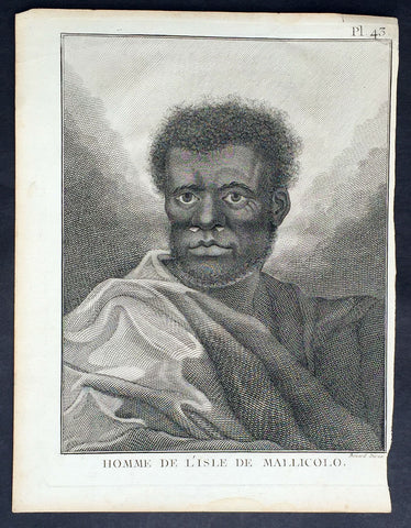
1778 Capt. Cook Antique Print Portrait A Man of Malakula Island Vanuatu in 1774
- Title : Homme de L Isle de Mallicolo
- Ref : 31773
- Size: 10in x 8in (255mm x 205mm)
- Date : 1778
- Condition: (A+) Fine Condition
Description:
This fine original copper-plate engraved antique print, portrait of a Man of the Island of Malakula (Mallicolo) in the Vanuatu group of Islands in the South Pacific, visited by Captain James Cook during his 2nd Voyage of Discovery in the South Seas in September 1774, was engraved by Robert Benard - after William Hodges - and was published in the 1778 French edition of Capt. James Cooks 2nd Voyage of Discovery to the South Seas A voyage towards the South Pole, and round the World. Performed in His Majestys ships the Resolution and Adventure, in the years 1772, 1773, 1774, and 1775..... Paris : Hotel de Thou ......1778
Cook Journal July, 1774
Arrival at The New Hebrides
On 17th Cook saw land bearing SW and later on decided this was the Australia Del Espiritu Santo of Quiros or what M. D. Bougainville calls the Great Cyclades. The island was Maewo. The next day its northern end was rounded in a gale and the ship sailed south between it and the island called by Bougainville the Isle of Lepers - Omba.
On 20th they crossed Patteson Passage with a view of geting to the South to explore the lands which lies there, and sailed down the west coast of Pentecost Isle (Raga). To the south they saw the island of Ambrin and behind it Paama and Epi. On 22nd, approaching Mallicollo (Malekula) we perceived a creek which had the appearence of a good harbour. Cook sent Lieutt [Richard] Pickersgill and the Master [Joseph Gilbert] in two Armd boats to Sound and look for Anchorage. The following day a good many [natives] came round us, some came in Canoes and others swam off\'... four I took into the Cabbin and made them various presents. Later, after some misunder-standing some natives began to Shoot Arrows... a Musquet discharged in the air and a four pounder over their heads sent them all off in the utmost confusion; those in the Cabbin leaped out of the Windows... About 9 o\'Clock we landed in the face of about 4 or 500 Men who were assembled on the Shore, armd with Bows and Arrows, clubs and Spears, but they made not the least opposission, on the contrary one Man gave his Arms to a nother and Met us in the water with a green branch in his hand, which [he] exchanged for the one I held in my hand. Just before departing Cook remarked they have not so much as a name for a Dog, consequently can have none, for which reason we left them a Dog and a Bitch.
General Definitions:
Paper thickness and quality: - Heavy and stable
Paper color : - off white
Age of map color: -
Colors used: -
General color appearance: -
Paper size: - 10in x 8in (255mm x 205mm)
Plate size: - 9 1/2in x 7 1/4in (240mm x 185mm)
Margins: - Min 1/2in (12mm)
Imperfections:
Margins: - Light soiling in margins
Plate area: - None
Verso: - None
Background:
Malakula Island also spelled Malekula, is the second-largest island in the nation of Vanuatu, in the Pacific Ocean region of Melanesia.
Discovered by the Spanish expedition of Pedro Fernández de Quirós in 1606 and visited by Captain Cook in 1774.
Vanuatu officially the Republic of Vanuatu is a Pacific island nation located in the South Pacific Ocean. The archipelago, which is of volcanic origin, is 1,750 kilometres east of northern Australia, 540 kilometres northeast of New Caledonia, east of New Guinea, southeast of the Solomon Islands, and west of Fiji.
Vanuatu was first inhabited by Melanesian people. The first Europeans to visit the islands were a Spanish expedition led by Portuguese navigator Fernandes de Queirós, who arrived on the largest island in 1606. Since the Portuguese and Spanish monarchies had been unified under the king of Spain in 1580 (following the vacancy of the Portuguese throne, which lasted for sixty years, until 1640, when the Portuguese monarchy was restored), Queirós claimed the archipelago for Spain, as part of the colonial Spanish East Indies, and named it La Austrialia del Espiritu Santo.
The Vanuatu group of islands first had contact with Europeans in 1606, when the Portuguese explorer Pedro Fernandes de Queiros, sailing for the Spanish Crown, arrived on the largest island and called the group of islands La Austrialia del Espiritu Santo or The Southern Land of the Holy Spirit, believing he had arrived in Terra Australis or Australia. The Spanish established a short-lived settlement at Big Bay on the north side of the island. The name Espiritu Santo remains to this day.
Europeans did not return until 1768, when Louis Antoine de Bougainville rediscovered the islands on 22 May, naming them the Great Cyclades. In 1774, Captain Cook named the islands the New Hebrides, a name that would last until independence in 1980.
William Hodges RA 1744 – 1797 was an English painter. He was a member of James Cooks second voyage to the Pacific Ocean, and is best known for the sketches and paintings of locations he visited on that voyage, including Table Bay, Tahiti, Easter Island, and the Antarctic.
Between 1772 and 1775 Hodges accompanied James Cook to the Pacific as the expeditions artist. Many of his sketches and wash paintings were adapted as engravings in the original published edition of Cooks journals from the voyage.
Most of the large-scale landscape oil paintings from his Pacific travels for which Hodges is best known were finished after his return to London; he received a salary from the Admiralty for the purposes of completing them. These paintings depicted a stronger light and shadow than had been usual in European landscape tradition. Contemporary art critics complained that his use of light and colour contrasts gave his paintings a rough and unfinished appearance.
Hodges also produced many valuable portrait sketches of Pacific islanders and scenes from the voyage involving members of the expedition..
Robert Bénard 1734 – 1777 was an 18th-century French engraver.
Specialized in the technique of engraving, Robert Ménard is mainly famous for having supplied a significant amount of plates (at least 1,800) to the Encyclopédie by Diderot & d\'Alembert from 1751.
Later, publisher Charles-Joseph Panckoucke reused many of his productions to illustrate the works of his catalog.
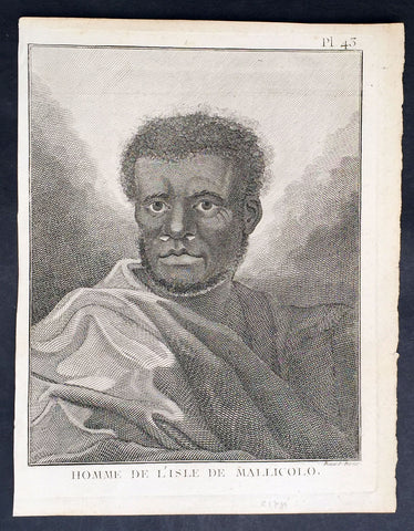
1778 Capt. Cook Antique Print Portrait A Man of Malakula Island Vanuatu in 1774
- Title : Homme de L Isle de Mallicolo
- Ref : 21347
- Size: 10in x 8in (255mm x 205mm)
- Date : 1778
- Condition: (A+) Fine Condition
Description:
This fine original copper-plate engraved antique print, portrait of a Man of the Island of Malakula (Mallicolo) in the Vanuatu group of Islands in the South Pacific, visited by Captain James Cook during his 2nd Voyage of Discovery in the South Seas in September 1774, was engraved by Robert Benard - after William Hodges - and was published in the 1778 French edition of Capt. James Cooks 2nd Voyage of Discovery to the South Seas A voyage towards the South Pole, and round the World. Performed in His Majestys ships the Resolution and Adventure, in the years 1772, 1773, 1774, and 1775..... Paris : Hotel de Thou ......1778
Cook Journal July, 1774
Arrival at The New Hebrides
On 17th Cook saw land bearing SW and later on decided this was the Australia Del Espiritu Santo of Quiros or what M. D. Bougainville calls the Great Cyclades. The island was Maewo. The next day its northern end was rounded in a gale and the ship sailed south between it and the island called by Bougainville the Isle of Lepers - Omba.
On 20th they crossed Patteson Passage with a view of geting to the South to explore the lands which lies there, and sailed down the west coast of Pentecost Isle (Raga). To the south they saw the island of Ambrin and behind it Paama and Epi. On 22nd, approaching Mallicollo (Malekula) we perceived a creek which had the appearence of a good harbour. Cook sent Lieutt [Richard] Pickersgill and the Master [Joseph Gilbert] in two Armd boats to Sound and look for Anchorage. The following day a good many [natives] came round us, some came in Canoes and others swam off\'... four I took into the Cabbin and made them various presents. Later, after some misunder-standing some natives began to Shoot Arrows... a Musquet discharged in the air and a four pounder over their heads sent them all off in the utmost confusion; those in the Cabbin leaped out of the Windows... About 9 o\'Clock we landed in the face of about 4 or 500 Men who were assembled on the Shore, armd with Bows and Arrows, clubs and Spears, but they made not the least opposission, on the contrary one Man gave his Arms to a nother and Met us in the water with a green branch in his hand, which [he] exchanged for the one I held in my hand. Just before departing Cook remarked they have not so much as a name for a Dog, consequently can have none, for which reason we left them a Dog and a Bitch.
General Definitions:
Paper thickness and quality: - Heavy and stable
Paper color : - off white
Age of map color: -
Colors used: -
General color appearance: -
Paper size: - 10in x 8in (255mm x 205mm)
Plate size: - 9 1/2in x 7 1/4in (240mm x 185mm)
Margins: - Min 1/2in (12mm)
Imperfections:
Margins: - Light soiling in margins
Plate area: - None
Verso: - None
Background:
Malakula Island also spelled Malekula, is the second-largest island in the nation of Vanuatu, in the Pacific Ocean region of Melanesia.
Discovered by the Spanish expedition of Pedro Fernández de Quirós in 1606 and visited by Captain Cook in 1774.
Vanuatu officially the Republic of Vanuatu is a Pacific island nation located in the South Pacific Ocean. The archipelago, which is of volcanic origin, is 1,750 kilometres east of northern Australia, 540 kilometres northeast of New Caledonia, east of New Guinea, southeast of the Solomon Islands, and west of Fiji.
Vanuatu was first inhabited by Melanesian people. The first Europeans to visit the islands were a Spanish expedition led by Portuguese navigator Fernandes de Queirós, who arrived on the largest island in 1606. Since the Portuguese and Spanish monarchies had been unified under the king of Spain in 1580 (following the vacancy of the Portuguese throne, which lasted for sixty years, until 1640, when the Portuguese monarchy was restored), Queirós claimed the archipelago for Spain, as part of the colonial Spanish East Indies, and named it La Austrialia del Espiritu Santo.
The Vanuatu group of islands first had contact with Europeans in 1606, when the Portuguese explorer Pedro Fernandes de Queiros, sailing for the Spanish Crown, arrived on the largest island and called the group of islands La Austrialia del Espiritu Santo or The Southern Land of the Holy Spirit, believing he had arrived in Terra Australis or Australia. The Spanish established a short-lived settlement at Big Bay on the north side of the island. The name Espiritu Santo remains to this day.
Europeans did not return until 1768, when Louis Antoine de Bougainville rediscovered the islands on 22 May, naming them the Great Cyclades. In 1774, Captain Cook named the islands the New Hebrides, a name that would last until independence in 1980.
William Hodges RA 1744 – 1797 was an English painter. He was a member of James Cooks second voyage to the Pacific Ocean, and is best known for the sketches and paintings of locations he visited on that voyage, including Table Bay, Tahiti, Easter Island, and the Antarctic.
Between 1772 and 1775 Hodges accompanied James Cook to the Pacific as the expeditions artist. Many of his sketches and wash paintings were adapted as engravings in the original published edition of Cooks journals from the voyage.
Most of the large-scale landscape oil paintings from his Pacific travels for which Hodges is best known were finished after his return to London; he received a salary from the Admiralty for the purposes of completing them. These paintings depicted a stronger light and shadow than had been usual in European landscape tradition. Contemporary art critics complained that his use of light and colour contrasts gave his paintings a rough and unfinished appearance.
Hodges also produced many valuable portrait sketches of Pacific islanders and scenes from the voyage involving members of the expedition..
Robert Bénard 1734 – 1777 was an 18th-century French engraver.
Specialized in the technique of engraving, Robert Ménard is mainly famous for having supplied a significant amount of plates (at least 1,800) to the Encyclopédie by Diderot & d\'Alembert from 1751.
Later, publisher Charles-Joseph Panckoucke reused many of his productions to illustrate the works of his catalog.
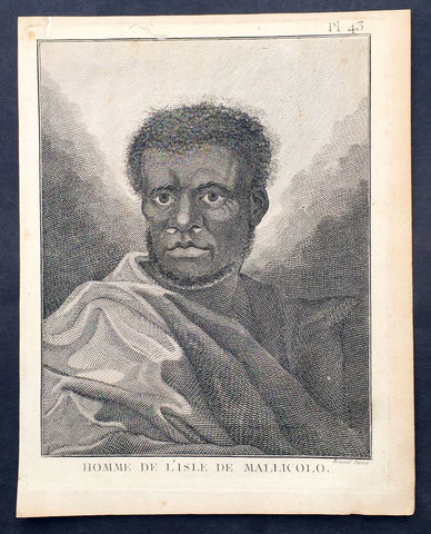
1778 Capt. Cook Antique Print Portrait A Man of Malakula Island Vanuatu in 1774
- Title : Homme de L Isle de Mallicolo
- Ref : 31831
- Size: 10in x 8in (255mm x 205mm)
- Date : 1778
- Condition: (A+) Fine Condition
Description:
This fine original copper-plate engraved antique print, portrait of a Man of the Island of Malakula (Mallicolo) in the Vanuatu group of Islands in the South Pacific, visited by Captain James Cook during his 2nd Voyage of Discovery in the South Seas in September 1774, was engraved by Robert Benard - after William Hodges - and was published in the 1778 French edition of Capt. James Cooks 2nd Voyage of Discovery to the South Seas A voyage towards the South Pole, and round the World. Performed in His Majestys ships the Resolution and Adventure, in the years 1772, 1773, 1774, and 1775..... Paris : Hotel de Thou ......1778
Cook Journal July, 1774
Arrival at The New Hebrides
On 17th Cook saw land bearing SW and later on decided this was the Australia Del Espiritu Santo of Quiros or what M. D. Bougainville calls the Great Cyclades. The island was Maewo. The next day its northern end was rounded in a gale and the ship sailed south between it and the island called by Bougainville the Isle of Lepers - Omba.
On 20th they crossed Patteson Passage with a view of geting to the South to explore the lands which lies there, and sailed down the west coast of Pentecost Isle (Raga). To the south they saw the island of Ambrin and behind it Paama and Epi. On 22nd, approaching Mallicollo (Malekula) we perceived a creek which had the appearence of a good harbour. Cook sent Lieutt [Richard] Pickersgill and the Master [Joseph Gilbert] in two Armd boats to Sound and look for Anchorage. The following day a good many [natives] came round us, some came in Canoes and others swam off\'... four I took into the Cabbin and made them various presents. Later, after some misunder-standing some natives began to Shoot Arrows... a Musquet discharged in the air and a four pounder over their heads sent them all off in the utmost confusion; those in the Cabbin leaped out of the Windows... About 9 o\'Clock we landed in the face of about 4 or 500 Men who were assembled on the Shore, armd with Bows and Arrows, clubs and Spears, but they made not the least opposission, on the contrary one Man gave his Arms to a nother and Met us in the water with a green branch in his hand, which [he] exchanged for the one I held in my hand. Just before departing Cook remarked they have not so much as a name for a Dog, consequently can have none, for which reason we left them a Dog and a Bitch.
General Definitions:
Paper thickness and quality: - Heavy and stable
Paper color : - off white
Age of map color: -
Colors used: -
General color appearance: -
Paper size: - 10in x 8in (255mm x 205mm)
Plate size: - 9 1/2in x 7 1/4in (240mm x 185mm)
Margins: - Min 1/2in (12mm)
Imperfections:
Margins: - Light soiling in margins
Plate area: - None
Verso: - None
Background:
Malakula Island also spelled Malekula, is the second-largest island in the nation of Vanuatu, in the Pacific Ocean region of Melanesia.
Discovered by the Spanish expedition of Pedro Fernández de Quirós in 1606 and visited by Captain Cook in 1774.
Vanuatu officially the Republic of Vanuatu is a Pacific island nation located in the South Pacific Ocean. The archipelago, which is of volcanic origin, is 1,750 kilometres east of northern Australia, 540 kilometres northeast of New Caledonia, east of New Guinea, southeast of the Solomon Islands, and west of Fiji.
Vanuatu was first inhabited by Melanesian people. The first Europeans to visit the islands were a Spanish expedition led by Portuguese navigator Fernandes de Queirós, who arrived on the largest island in 1606. Since the Portuguese and Spanish monarchies had been unified under the king of Spain in 1580 (following the vacancy of the Portuguese throne, which lasted for sixty years, until 1640, when the Portuguese monarchy was restored), Queirós claimed the archipelago for Spain, as part of the colonial Spanish East Indies, and named it La Austrialia del Espiritu Santo.
The Vanuatu group of islands first had contact with Europeans in 1606, when the Portuguese explorer Pedro Fernandes de Queiros, sailing for the Spanish Crown, arrived on the largest island and called the group of islands La Austrialia del Espiritu Santo or The Southern Land of the Holy Spirit, believing he had arrived in Terra Australis or Australia. The Spanish established a short-lived settlement at Big Bay on the north side of the island. The name Espiritu Santo remains to this day.
Europeans did not return until 1768, when Louis Antoine de Bougainville rediscovered the islands on 22 May, naming them the Great Cyclades. In 1774, Captain Cook named the islands the New Hebrides, a name that would last until independence in 1980.
William Hodges RA 1744 – 1797 was an English painter. He was a member of James Cooks second voyage to the Pacific Ocean, and is best known for the sketches and paintings of locations he visited on that voyage, including Table Bay, Tahiti, Easter Island, and the Antarctic.
Between 1772 and 1775 Hodges accompanied James Cook to the Pacific as the expeditions artist. Many of his sketches and wash paintings were adapted as engravings in the original published edition of Cooks journals from the voyage.
Most of the large-scale landscape oil paintings from his Pacific travels for which Hodges is best known were finished after his return to London; he received a salary from the Admiralty for the purposes of completing them. These paintings depicted a stronger light and shadow than had been usual in European landscape tradition. Contemporary art critics complained that his use of light and colour contrasts gave his paintings a rough and unfinished appearance.
Hodges also produced many valuable portrait sketches of Pacific islanders and scenes from the voyage involving members of the expedition..
Robert Bénard 1734 – 1777 was an 18th-century French engraver.
Specialized in the technique of engraving, Robert Ménard is mainly famous for having supplied a significant amount of plates (at least 1,800) to the Encyclopédie by Diderot & d\'Alembert from 1751.
Later, publisher Charles-Joseph Panckoucke reused many of his productions to illustrate the works of his catalog.
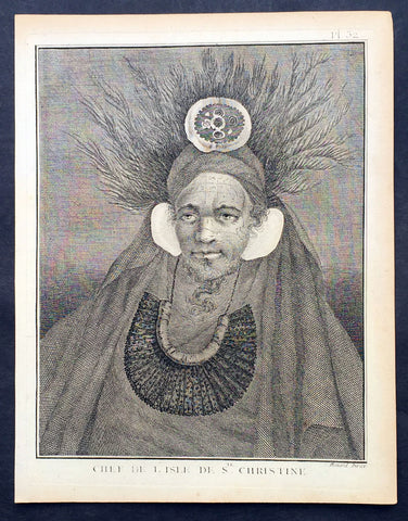
1778 Capt. Cook Antique Print Portrait Chief of Tahuata, Marquesas Isles in 1774
- Title : Chef De L Isle de Ste. Christine
- Ref : 31807
- Size: 10in x 8in (255mm x 205mm)
- Date : 1778
- Condition: (A+) Fine Condition
Description:
This fine original copper-plate engraved antique print, a portrait of Chief of Tahuata Island, Santa Cristina, in the Marquesas Islands, South Pacific, visited by Captain James Cook during his 2nd Voyage of Discovery in the South Seas in 1774, was engraved by Robert Benard - after William Hodges - and was published in the 1778 French edition of Capt. James Cooks 2nd Voyage of Discovery to the South Seas A voyage towards the South Pole, and round the World. Performed in His Majestys ships the Resolution and Adventure, in the years 1772, 1773, 1774, and 1775..... Paris : Hotel de Thou ......1778
Cook Diary (1774)
Apr. 7 Thu. Sights Hood’s Island (Fatu Huku), St. Pedro (Motare). La Dominica (Hiva Oa), St. Christina (Tahuata).
Apr 8 Fri. Sails along southern coast of Hiva Oa looking for anchorage. Anchors in Resolution (formerly Madre de Dios) Bay (Vaitahu Bay). Canoes arrive, gifts are exchanged. Natives killed after an iron stanchion is stolen.
Apr 9 Sat. Goes ashore, gifts exchanged, food obtained.
Apr 10 Sun. Goes ashore to south end of Bay and visits house of dead man. Gifts exchanged.
Apr 11 Mon. Goes ashore to south, again. Finds trade becoming expensive because of lavish gifts by his “gentlemen”.
Apr 12 Tue. Sails towards St. Dominica. No anchorage visible. Heads SW away from islands.
Apr 13 Wed. Sights last of the five main islands, Magdalena (Fatu Hiva).
General Definitions:
Paper thickness and quality: - Heavy and stable
Paper color : - off white
Age of map color: -
Colors used: -
General color appearance: -
Paper size: - 10in x 8in (255mm x 205mm)
Plate size: - 9 1/2in x 7 1/4in (240mm x 185mm)
Margins: - Min 1/2in (12mm)
Imperfections:
Margins: - Light soiling in margins
Plate area: - None
Verso: - None
Background:
Tahuata is the smallest of the inhabited Marquesas Islands, in French Polynesia, an overseas territory of France in the Pacific Ocean.
The first recorded sighting by Europeans was by the Spanish expedition of Álvaro de Mandaña on 22 July 1595. They charted the island as Santa Cristina. They landed at Vaitahu that they named Madre de Dios (Gods Mother in Spanish). According to the Spanish accounts Tahuata had fowls, fish, sugar cane, plantains, nuts and fruits. The existent town was built on two sides of a rectangular space, the houses being of timber and intertwined canes. A building which the Spaniards supposed to be a religious one stood outside the town, in a space enclosed by palisades, and containing some ill-carved images before which were offerings and provisions. The people had large and well constructed sailing canoes. Their tools were made of shells and fish bones. They used slings, stones, and lances as weapons.
Tahuata was visited by Captain James Cook in 1774 and Admiral Dupetit-Thouars in 1842, who signed the treaty annexing the Marquesas Islands to France.
The Marquesas Islands are a group of volcanic islands in French Polynesia, an overseas collective of France in the southern Pacific Ocean.
The first Europeans to reach the Marquesas may have been the crew of San Lesmes, a Spanish vessel which disappeared in a storm in June 1526; it was part of an expedition headed by García Jofre de Loaísa. The Spanish explorer Álvaro de Mendaña reached them seventy years later on 21 July 1595. He named them after his patron, García Hurtado de Mendoza, 5th Marquis of Cañete (Spanish: Marqués de Cañete), who served as Viceroy of Peru from 1590 to 1596. |Mendaña visited first Fatu Hiva and then Tahuata before continuing on to the Solomon Islands. His expedition charted the four southernmost Marquesas as Magdalena (Fatu Hiva), Dominica (Hiva ʻOa), San Pedro (Moho Tani), and Santa Cristina (Tahuata).
In the late 16th century European explorers estimated the population at more than 100,000. Europeans and Americans were impressed with how easy life appeared to be in the islands, which had a rich habitat and environment. In 1791 the American maritime fur trader Joseph Ingraham first visited the northern Marquesas while commanding the brig Hope. He named them the Washington Islands. In 1813 Commodore David Porter claimed Nuku Hiva for the United States, but the United States Congress never ratified that claim.
In 1842 France conducted a successful military operation on behalf of the native chief Iotete, who claimed he was king of the whole island of Tahuata. The government laid claim to the whole group and established a settlement on Nuku Hiva. That settlement was abandoned in 1857, but France re-established control over the group in 1870. It later incorporated the Marquesas into French Polynesia.
William Hodges RA 1744 – 1797 was an English painter. He was a member of James Cooks second voyage to the Pacific Ocean, and is best known for the sketches and paintings of locations he visited on that voyage, including Table Bay, Tahiti, Easter Island, and the Antarctic.
Between 1772 and 1775 Hodges accompanied James Cook to the Pacific as the expeditions artist. Many of his sketches and wash paintings were adapted as engravings in the original published edition of Cooks journals from the voyage.
Most of the large-scale landscape oil paintings from his Pacific travels for which Hodges is best known were finished after his return to London; he received a salary from the Admiralty for the purposes of completing them. These paintings depicted a stronger light and shadow than had been usual in European landscape tradition. Contemporary art critics complained that his use of light and colour contrasts gave his paintings a rough and unfinished appearance.
Hodges also produced many valuable portrait sketches of Pacific islanders and scenes from the voyage involving members of the expedition..
Robert Bénard 1734 – 1777 was an 18th-century French engraver.
Specialized in the technique of engraving, Robert Ménard is mainly famous for having supplied a significant amount of plates (at least 1,800) to the Encyclopédie by Diderot & d\'Alembert from 1751.
Later, publisher Charles-Joseph Panckoucke reused many of his productions to illustrate the works of his catalog.
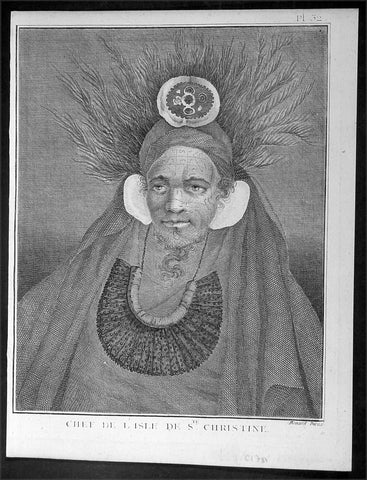
1778 Capt. Cook Antique Print Portrait Chief of Tahuata, Marquesas Isles in 1774
- Title : Chef De L Isle de Ste. Christine
- Ref : 21328
- Size: 10in x 8in (255mm x 205mm)
- Date : 1778
- Condition: (A+) Fine Condition
Description:
This fine original copper-plate engraved antique print, a portrait of Chief of Tahuata Island, Santa Cristina, in the Marquesas Islands, South Pacific, visited by Captain James Cook during his 2nd Voyage of Discovery in the South Seas in 1774, was engraved by Robert Benard - after William Hodges - and was published in the 1778 French edition of Capt. James Cooks 2nd Voyage of Discovery to the South Seas A voyage towards the South Pole, and round the World. Performed in His Majestys ships the Resolution and Adventure, in the years 1772, 1773, 1774, and 1775..... Paris : Hotel de Thou ......1778
Cook Diary (1774)
Apr. 7 Thu. Sights Hood’s Island (Fatu Huku), St. Pedro (Motare). La Dominica (Hiva Oa), St. Christina (Tahuata).
Apr 8 Fri. Sails along southern coast of Hiva Oa looking for anchorage. Anchors in Resolution (formerly Madre de Dios) Bay (Vaitahu Bay). Canoes arrive, gifts are exchanged. Natives killed after an iron stanchion is stolen.
Apr 9 Sat. Goes ashore, gifts exchanged, food obtained.
Apr 10 Sun. Goes ashore to south end of Bay and visits house of dead man. Gifts exchanged.
Apr 11 Mon. Goes ashore to south, again. Finds trade becoming expensive because of lavish gifts by his “gentlemen”.
Apr 12 Tue. Sails towards St. Dominica. No anchorage visible. Heads SW away from islands.
Apr 13 Wed. Sights last of the five main islands, Magdalena (Fatu Hiva).
General Definitions:
Paper thickness and quality: - Heavy and stable
Paper color : - off white
Age of map color: -
Colors used: -
General color appearance: -
Paper size: - 10in x 8in (255mm x 205mm)
Plate size: - 9 1/2in x 7 1/4in (240mm x 185mm)
Margins: - Min 1/2in (12mm)
Imperfections:
Margins: - Light soiling in margins
Plate area: - None
Verso: - None
Background:
Tahuata is the smallest of the inhabited Marquesas Islands, in French Polynesia, an overseas territory of France in the Pacific Ocean.
The first recorded sighting by Europeans was by the Spanish expedition of Álvaro de Mandaña on 22 July 1595. They charted the island as Santa Cristina. They landed at Vaitahu that they named Madre de Dios (Gods Mother in Spanish). According to the Spanish accounts Tahuata had fowls, fish, sugar cane, plantains, nuts and fruits. The existent town was built on two sides of a rectangular space, the houses being of timber and intertwined canes. A building which the Spaniards supposed to be a religious one stood outside the town, in a space enclosed by palisades, and containing some ill-carved images before which were offerings and provisions. The people had large and well constructed sailing canoes. Their tools were made of shells and fish bones. They used slings, stones, and lances as weapons.
Tahuata was visited by Captain James Cook in 1774 and Admiral Dupetit-Thouars in 1842, who signed the treaty annexing the Marquesas Islands to France.
The Marquesas Islands are a group of volcanic islands in French Polynesia, an overseas collective of France in the southern Pacific Ocean.
The first Europeans to reach the Marquesas may have been the crew of San Lesmes, a Spanish vessel which disappeared in a storm in June 1526; it was part of an expedition headed by García Jofre de Loaísa. The Spanish explorer Álvaro de Mendaña reached them seventy years later on 21 July 1595. He named them after his patron, García Hurtado de Mendoza, 5th Marquis of Cañete (Spanish: Marqués de Cañete), who served as Viceroy of Peru from 1590 to 1596. |Mendaña visited first Fatu Hiva and then Tahuata before continuing on to the Solomon Islands. His expedition charted the four southernmost Marquesas as Magdalena (Fatu Hiva), Dominica (Hiva ʻOa), San Pedro (Moho Tani), and Santa Cristina (Tahuata).
In the late 16th century European explorers estimated the population at more than 100,000. Europeans and Americans were impressed with how easy life appeared to be in the islands, which had a rich habitat and environment. In 1791 the American maritime fur trader Joseph Ingraham first visited the northern Marquesas while commanding the brig Hope. He named them the Washington Islands. In 1813 Commodore David Porter claimed Nuku Hiva for the United States, but the United States Congress never ratified that claim.
In 1842 France conducted a successful military operation on behalf of the native chief Iotete, who claimed he was king of the whole island of Tahuata. The government laid claim to the whole group and established a settlement on Nuku Hiva. That settlement was abandoned in 1857, but France re-established control over the group in 1870. It later incorporated the Marquesas into French Polynesia.
William Hodges RA 1744 – 1797 was an English painter. He was a member of James Cooks second voyage to the Pacific Ocean, and is best known for the sketches and paintings of locations he visited on that voyage, including Table Bay, Tahiti, Easter Island, and the Antarctic.
Between 1772 and 1775 Hodges accompanied James Cook to the Pacific as the expeditions artist. Many of his sketches and wash paintings were adapted as engravings in the original published edition of Cooks journals from the voyage.
Most of the large-scale landscape oil paintings from his Pacific travels for which Hodges is best known were finished after his return to London; he received a salary from the Admiralty for the purposes of completing them. These paintings depicted a stronger light and shadow than had been usual in European landscape tradition. Contemporary art critics complained that his use of light and colour contrasts gave his paintings a rough and unfinished appearance.
Hodges also produced many valuable portrait sketches of Pacific islanders and scenes from the voyage involving members of the expedition..
Robert Bénard 1734 – 1777 was an 18th-century French engraver.
Specialized in the technique of engraving, Robert Ménard is mainly famous for having supplied a significant amount of plates (at least 1,800) to the Encyclopédie by Diderot & d\'Alembert from 1751.
Later, publisher Charles-Joseph Panckoucke reused many of his productions to illustrate the works of his catalog.
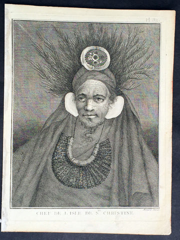
1778 Capt. Cook Antique Print Portrait Chief of Tahuata, Marquesas Isles in 1774
- Title : Chef De L Isle de Ste. Christine
- Ref : 31779
- Size: 10in x 8in (255mm x 205mm)
- Date : 1778
- Condition: (A+) Fine Condition
Description:
This fine original copper-plate engraved antique print, a portrait of Chief of Tahuata Island, Santa Cristina, in the Marquesas Islands, South Pacific, visited by Captain James Cook during his 2nd Voyage of Discovery in the South Seas in 1774, was engraved by Robert Benard - after William Hodges - and was published in the 1778 French edition of Capt. James Cooks 2nd Voyage of Discovery to the South Seas A voyage towards the South Pole, and round the World. Performed in His Majestys ships the Resolution and Adventure, in the years 1772, 1773, 1774, and 1775..... Paris : Hotel de Thou ......1778
Cook Diary (1774)
Apr. 7 Thu. Sights Hood’s Island (Fatu Huku), St. Pedro (Motare). La Dominica (Hiva Oa), St. Christina (Tahuata).
Apr 8 Fri. Sails along southern coast of Hiva Oa looking for anchorage. Anchors in Resolution (formerly Madre de Dios) Bay (Vaitahu Bay). Canoes arrive, gifts are exchanged. Natives killed after an iron stanchion is stolen.
Apr 9 Sat. Goes ashore, gifts exchanged, food obtained.
Apr 10 Sun. Goes ashore to south end of Bay and visits house of dead man. Gifts exchanged.
Apr 11 Mon. Goes ashore to south, again. Finds trade becoming expensive because of lavish gifts by his “gentlemen”.
Apr 12 Tue. Sails towards St. Dominica. No anchorage visible. Heads SW away from islands.
Apr 13 Wed. Sights last of the five main islands, Magdalena (Fatu Hiva).
General Definitions:
Paper thickness and quality: - Heavy and stable
Paper color : - off white
Age of map color: -
Colors used: -
General color appearance: -
Paper size: - 10in x 8in (255mm x 205mm)
Plate size: - 9 1/2in x 7 1/4in (240mm x 185mm)
Margins: - Min 1/2in (12mm)
Imperfections:
Margins: - Light soiling in margins
Plate area: - None
Verso: - None
Background:
Tahuata is the smallest of the inhabited Marquesas Islands, in French Polynesia, an overseas territory of France in the Pacific Ocean.
The first recorded sighting by Europeans was by the Spanish expedition of Álvaro de Mandaña on 22 July 1595. They charted the island as Santa Cristina. They landed at Vaitahu that they named Madre de Dios (Gods Mother in Spanish). According to the Spanish accounts Tahuata had fowls, fish, sugar cane, plantains, nuts and fruits. The existent town was built on two sides of a rectangular space, the houses being of timber and intertwined canes. A building which the Spaniards supposed to be a religious one stood outside the town, in a space enclosed by palisades, and containing some ill-carved images before which were offerings and provisions. The people had large and well constructed sailing canoes. Their tools were made of shells and fish bones. They used slings, stones, and lances as weapons.
Tahuata was visited by Captain James Cook in 1774 and Admiral Dupetit-Thouars in 1842, who signed the treaty annexing the Marquesas Islands to France.
The Marquesas Islands are a group of volcanic islands in French Polynesia, an overseas collective of France in the southern Pacific Ocean.
The first Europeans to reach the Marquesas may have been the crew of San Lesmes, a Spanish vessel which disappeared in a storm in June 1526; it was part of an expedition headed by García Jofre de Loaísa. The Spanish explorer Álvaro de Mendaña reached them seventy years later on 21 July 1595. He named them after his patron, García Hurtado de Mendoza, 5th Marquis of Cañete (Spanish: Marqués de Cañete), who served as Viceroy of Peru from 1590 to 1596. |Mendaña visited first Fatu Hiva and then Tahuata before continuing on to the Solomon Islands. His expedition charted the four southernmost Marquesas as Magdalena (Fatu Hiva), Dominica (Hiva ʻOa), San Pedro (Moho Tani), and Santa Cristina (Tahuata).
In the late 16th century European explorers estimated the population at more than 100,000. Europeans and Americans were impressed with how easy life appeared to be in the islands, which had a rich habitat and environment. In 1791 the American maritime fur trader Joseph Ingraham first visited the northern Marquesas while commanding the brig Hope. He named them the Washington Islands. In 1813 Commodore David Porter claimed Nuku Hiva for the United States, but the United States Congress never ratified that claim.
In 1842 France conducted a successful military operation on behalf of the native chief Iotete, who claimed he was king of the whole island of Tahuata. The government laid claim to the whole group and established a settlement on Nuku Hiva. That settlement was abandoned in 1857, but France re-established control over the group in 1870. It later incorporated the Marquesas into French Polynesia.
William Hodges RA 1744 – 1797 was an English painter. He was a member of James Cooks second voyage to the Pacific Ocean, and is best known for the sketches and paintings of locations he visited on that voyage, including Table Bay, Tahiti, Easter Island, and the Antarctic.
Between 1772 and 1775 Hodges accompanied James Cook to the Pacific as the expeditions artist. Many of his sketches and wash paintings were adapted as engravings in the original published edition of Cooks journals from the voyage.
Most of the large-scale landscape oil paintings from his Pacific travels for which Hodges is best known were finished after his return to London; he received a salary from the Admiralty for the purposes of completing them. These paintings depicted a stronger light and shadow than had been usual in European landscape tradition. Contemporary art critics complained that his use of light and colour contrasts gave his paintings a rough and unfinished appearance.
Hodges also produced many valuable portrait sketches of Pacific islanders and scenes from the voyage involving members of the expedition..
Robert Bénard 1734 – 1777 was an 18th-century French engraver.
Specialized in the technique of engraving, Robert Ménard is mainly famous for having supplied a significant amount of plates (at least 1,800) to the Encyclopédie by Diderot & d\'Alembert from 1751.
Later, publisher Charles-Joseph Panckoucke reused many of his productions to illustrate the works of his catalog.
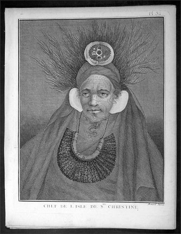
1778 Capt. Cook Antique Print Portrait Chief of Tahuata, Marquesas Isles in 1774
- Title : Chef De L Isle de Ste. Christine
- Ref : 16348
- Size: 10in x 8in (255mm x 205mm)
- Date : 1778
- Condition: (A+) Fine Condition
Description:
This fine original copper-plate engraved antique print, a portrait of Chief of Tahuata Island, Santa Cristina, in the Marquesas Islands, South Pacific, visited by Captain James Cook during his 2nd Voyage of Discovery in the South Seas in 1774, was engraved by Robert Benard - after William Hodges - and was published in the 1778 French edition of Capt. James Cooks 2nd Voyage of Discovery to the South Seas A voyage towards the South Pole, and round the World. Performed in His Majestys ships the Resolution and Adventure, in the years 1772, 1773, 1774, and 1775..... Paris : Hotel de Thou ......1778
Cook Diary (1774)
Apr. 7 Thu. Sights Hood’s Island (Fatu Huku), St. Pedro (Motare). La Dominica (Hiva Oa), St. Christina (Tahuata).
Apr 8 Fri. Sails along southern coast of Hiva Oa looking for anchorage. Anchors in Resolution (formerly Madre de Dios) Bay (Vaitahu Bay). Canoes arrive, gifts are exchanged. Natives killed after an iron stanchion is stolen.
Apr 9 Sat. Goes ashore, gifts exchanged, food obtained.
Apr 10 Sun. Goes ashore to south end of Bay and visits house of dead man. Gifts exchanged.
Apr 11 Mon. Goes ashore to south, again. Finds trade becoming expensive because of lavish gifts by his “gentlemen”.
Apr 12 Tue. Sails towards St. Dominica. No anchorage visible. Heads SW away from islands.
Apr 13 Wed. Sights last of the five main islands, Magdalena (Fatu Hiva).
General Definitions:
Paper thickness and quality: - Heavy and stable
Paper color : - off white
Age of map color: -
Colors used: -
General color appearance: -
Paper size: - 10in x 8in (255mm x 205mm)
Plate size: - 9 1/2in x 7 1/4in (240mm x 185mm)
Margins: - Min 1/2in (12mm)
Imperfections:
Margins: - Light soiling in margins
Plate area: - None
Verso: - None
Background:
Tahuata is the smallest of the inhabited Marquesas Islands, in French Polynesia, an overseas territory of France in the Pacific Ocean.
The first recorded sighting by Europeans was by the Spanish expedition of Álvaro de Mandaña on 22 July 1595. They charted the island as Santa Cristina. They landed at Vaitahu that they named Madre de Dios (Gods Mother in Spanish). According to the Spanish accounts Tahuata had fowls, fish, sugar cane, plantains, nuts and fruits. The existent town was built on two sides of a rectangular space, the houses being of timber and intertwined canes. A building which the Spaniards supposed to be a religious one stood outside the town, in a space enclosed by palisades, and containing some ill-carved images before which were offerings and provisions. The people had large and well constructed sailing canoes. Their tools were made of shells and fish bones. They used slings, stones, and lances as weapons.
Tahuata was visited by Captain James Cook in 1774 and Admiral Dupetit-Thouars in 1842, who signed the treaty annexing the Marquesas Islands to France.
The Marquesas Islands are a group of volcanic islands in French Polynesia, an overseas collective of France in the southern Pacific Ocean.
The first Europeans to reach the Marquesas may have been the crew of San Lesmes, a Spanish vessel which disappeared in a storm in June 1526; it was part of an expedition headed by García Jofre de Loaísa. The Spanish explorer Álvaro de Mendaña reached them seventy years later on 21 July 1595. He named them after his patron, García Hurtado de Mendoza, 5th Marquis of Cañete (Spanish: Marqués de Cañete), who served as Viceroy of Peru from 1590 to 1596. |Mendaña visited first Fatu Hiva and then Tahuata before continuing on to the Solomon Islands. His expedition charted the four southernmost Marquesas as Magdalena (Fatu Hiva), Dominica (Hiva ʻOa), San Pedro (Moho Tani), and Santa Cristina (Tahuata).
In the late 16th century European explorers estimated the population at more than 100,000. Europeans and Americans were impressed with how easy life appeared to be in the islands, which had a rich habitat and environment. In 1791 the American maritime fur trader Joseph Ingraham first visited the northern Marquesas while commanding the brig Hope. He named them the Washington Islands. In 1813 Commodore David Porter claimed Nuku Hiva for the United States, but the United States Congress never ratified that claim.
In 1842 France conducted a successful military operation on behalf of the native chief Iotete, who claimed he was king of the whole island of Tahuata. The government laid claim to the whole group and established a settlement on Nuku Hiva. That settlement was abandoned in 1857, but France re-established control over the group in 1870. It later incorporated the Marquesas into French Polynesia.
William Hodges RA 1744 – 1797 was an English painter. He was a member of James Cooks second voyage to the Pacific Ocean, and is best known for the sketches and paintings of locations he visited on that voyage, including Table Bay, Tahiti, Easter Island, and the Antarctic.
Between 1772 and 1775 Hodges accompanied James Cook to the Pacific as the expeditions artist. Many of his sketches and wash paintings were adapted as engravings in the original published edition of Cooks journals from the voyage.
Most of the large-scale landscape oil paintings from his Pacific travels for which Hodges is best known were finished after his return to London; he received a salary from the Admiralty for the purposes of completing them. These paintings depicted a stronger light and shadow than had been usual in European landscape tradition. Contemporary art critics complained that his use of light and colour contrasts gave his paintings a rough and unfinished appearance.
Hodges also produced many valuable portrait sketches of Pacific islanders and scenes from the voyage involving members of the expedition..
Robert Bénard 1734 – 1777 was an 18th-century French engraver.
Specialized in the technique of engraving, Robert Ménard is mainly famous for having supplied a significant amount of plates (at least 1,800) to the Encyclopédie by Diderot & d\'Alembert from 1751.
Later, publisher Charles-Joseph Panckoucke reused many of his productions to illustrate the works of his catalog.
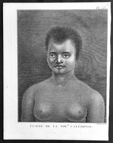
1778 Capt. Cook Antique Print Portrait of a Woman of New Caledonia Visit in 1774
- Title : Femme de la Noule. Caledonie
- Ref : 91210
- Size: 10in x 8in (255mm x 205mm)
- Date : 1778
- Condition: (A+) Fine Condition
Description:
This fine original copper-plate engraved antique print, portrait of a Woman of the Islands of New Caledonia in the South Pacific, visited by Captain James Cook during his 2nd Voyage of Discovery in the South Seas in September 1774, was engraved by Robert Benard - after William Hodges - and was published in the 1778 French edition of Capt. James Cooks 2nd Voyage of Discovery to the South Seas A voyage towards the South Pole, and round the World. Performed in His Majestys ships the Resolution and Adventure, in the years 1772, 1773, 1774, and 1775..... Paris : Hotel de Thou ......1778
Cook Diary, 4-13th Sep. 1774
4th Sun. Sights Cape Colnett (New Caledonia).
5th Mon. Enters reef (Amoss Passage) between Cook Reef and Balade Reef, anchors off Observatory Isle (Pudiu), visited by inhabitants.
6th Tue. Goes ashore with armed boats, rows along coast, returns to ship. Visited by natives, meets Chief, Teeabooma. Wales and Pickersgill land on Isle, Cook goes to help. Observatory set up for eclipse of Sun.
7th Wed. Eclipse, cloudy at first, observations made. Returns to ship, goes ashore again and returns. Simon Monk, ship’s butcher, dies after fall down fore-hatchway previous night.
8th Thu. Goes ashore. Excursion to west. The Forsters and Cook are ill with eating poisoned fish, liver and roe (Toadfish).
9th Fri. Exchanges presents with Teeabooma but still indisposed.
10th Sat. Forster ashore botanising.
12th Mon. Cutter is damaged when Gilbert and Pickersgill are returning from a visit to the north-west of island. Repairs made.
13th Tue. Takes possession of island in name of King George III, naming it New Caledonia. Sails back through reef and heads NW. along coast, outside Cook Reef, passes Great False Passage.
General Definitions:
Paper thickness and quality: - Heavy and stable
Paper color : - off white
Age of map color: -
Colors used: -
General color appearance: -
Paper size: - 10in x 8in (255mm x 205mm)
Plate size: - 9 1/2in x 7 1/4in (240mm x 185mm)
Margins: - Min 1/2in (12mm)
Imperfections:
Margins: - Light soiling in margins
Plate area: - None
Verso: - None
Background:
New Caledonia is a special collective of France in the southwest Pacific Ocean, 1,210 km east of Australia and 20,000 km from Metropolitan France. The archipelago, part of the Melanesia sub-region, includes the main island of Grande Terre, the Loyalty Islands, the Chesterfield Islands, the Belep archipelago, the Isle of Pines, and a few remote islets. The Chesterfield Islands are in the Coral Sea. Locals refer to Grande Terre as Le Caillou (the pebble)
British explorer Captain James Cook was the first European to sight New Caledonia, on 4 September 1774, during his second voyage. He named it New Caledonia, as the northeast of the island reminded him of Scotland. The west coast of Grande Terre was approached by Jean-François de Galaup, comte de Lapérouse in 1788, shortly before his disappearance, and the Loyalty Islands were first visited between 1793 and 1796 when Mare, Lifou, Tiga, and Ouvea were mapped by William Raven. The American whaler encountered the island named then Britania, and today known as Mar (Loyalty Is.) in November 1793. From 1796 until 1840, only a few sporadic contacts with the archipelago were recorded. About fifty American whalers (identified by Robert Langsom from their log books) have been recorded in the region (Grande Terre, Loyalty Is., Walpole and Hunter) between 1793 and 1887. Contacts became more frequent after 1840, because of the interest in sandalwood
William Hodges RA 1744 – 1797 was an English painter. He was a member of James Cooks second voyage to the Pacific Ocean, and is best known for the sketches and paintings of locations he visited on that voyage, including Table Bay, Tahiti, Easter Island, and the Antarctic.
Between 1772 and 1775 Hodges accompanied James Cook to the Pacific as the expeditions artist. Many of his sketches and wash paintings were adapted as engravings in the original published edition of Cooks journals from the voyage.
Most of the large-scale landscape oil paintings from his Pacific travels for which Hodges is best known were finished after his return to London; he received a salary from the Admiralty for the purposes of completing them. These paintings depicted a stronger light and shadow than had been usual in European landscape tradition. Contemporary art critics complained that his use of light and colour contrasts gave his paintings a rough and unfinished appearance.
Hodges also produced many valuable portrait sketches of Pacific islanders and scenes from the voyage involving members of the expedition..
Robert Bénard 1734 – 1777 was an 18th-century French engraver.
Specialized in the technique of engraving, Robert Ménard is mainly famous for having supplied a significant amount of plates (at least 1,800) to the Encyclopédie by Diderot & d\'Alembert from 1751.
Later, publisher Charles-Joseph Panckoucke reused many of his productions to illustrate the works of his catalog.
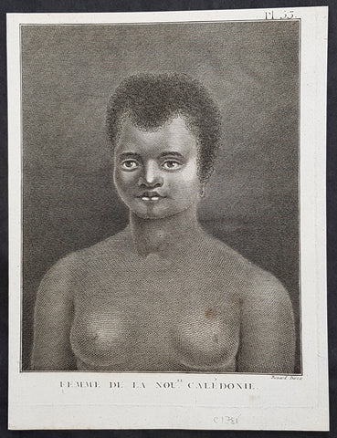
1778 Capt. Cook Antique Print Portrait of a Woman of New Caledonia Visit in 1774
- Title : Femme de la Noule. Caledonie
- Ref : 21327
- Size: 10in x 8in (255mm x 205mm)
- Date : 1778
- Condition: (A+) Fine Condition
Description:
This fine original copper-plate engraved antique print, portrait of a Woman of the Islands of New Caledonia in the South Pacific, visited by Captain James Cook during his 2nd Voyage of Discovery in the South Seas in September 1774, was engraved by Robert Benard - after William Hodges - and was published in the 1778 French edition of Capt. James Cooks 2nd Voyage of Discovery to the South Seas A voyage towards the South Pole, and round the World. Performed in His Majestys ships the Resolution and Adventure, in the years 1772, 1773, 1774, and 1775..... Paris : Hotel de Thou ......1778
Cook Diary, 4-13th Sep. 1774
4th Sun. Sights Cape Colnett (New Caledonia).
5th Mon. Enters reef (Amoss Passage) between Cook Reef and Balade Reef, anchors off Observatory Isle (Pudiu), visited by inhabitants.
6th Tue. Goes ashore with armed boats, rows along coast, returns to ship. Visited by natives, meets Chief, Teeabooma. Wales and Pickersgill land on Isle, Cook goes to help. Observatory set up for eclipse of Sun.
7th Wed. Eclipse, cloudy at first, observations made. Returns to ship, goes ashore again and returns. Simon Monk, ship’s butcher, dies after fall down fore-hatchway previous night.
8th Thu. Goes ashore. Excursion to west. The Forsters and Cook are ill with eating poisoned fish, liver and roe (Toadfish).
9th Fri. Exchanges presents with Teeabooma but still indisposed.
10th Sat. Forster ashore botanising.
12th Mon. Cutter is damaged when Gilbert and Pickersgill are returning from a visit to the north-west of island. Repairs made.
13th Tue. Takes possession of island in name of King George III, naming it New Caledonia. Sails back through reef and heads NW. along coast, outside Cook Reef, passes Great False Passage.
General Definitions:
Paper thickness and quality: - Heavy and stable
Paper color : - off white
Age of map color: -
Colors used: -
General color appearance: -
Paper size: - 10in x 8in (255mm x 205mm)
Plate size: - 9 1/2in x 7 1/4in (240mm x 185mm)
Margins: - Min 1/2in (12mm)
Imperfections:
Margins: - Light soiling in margins
Plate area: - None
Verso: - None
Background:
New Caledonia is a special collective of France in the southwest Pacific Ocean, 1,210 km east of Australia and 20,000 km from Metropolitan France. The archipelago, part of the Melanesia sub-region, includes the main island of Grande Terre, the Loyalty Islands, the Chesterfield Islands, the Belep archipelago, the Isle of Pines, and a few remote islets. The Chesterfield Islands are in the Coral Sea. Locals refer to Grande Terre as Le Caillou (the pebble)
British explorer Captain James Cook was the first European to sight New Caledonia, on 4 September 1774, during his second voyage. He named it New Caledonia, as the northeast of the island reminded him of Scotland. The west coast of Grande Terre was approached by Jean-François de Galaup, comte de Lapérouse in 1788, shortly before his disappearance, and the Loyalty Islands were first visited between 1793 and 1796 when Mare, Lifou, Tiga, and Ouvea were mapped by William Raven. The American whaler encountered the island named then Britania, and today known as Mar (Loyalty Is.) in November 1793. From 1796 until 1840, only a few sporadic contacts with the archipelago were recorded. About fifty American whalers (identified by Robert Langsom from their log books) have been recorded in the region (Grande Terre, Loyalty Is., Walpole and Hunter) between 1793 and 1887. Contacts became more frequent after 1840, because of the interest in sandalwood
William Hodges RA 1744 – 1797 was an English painter. He was a member of James Cooks second voyage to the Pacific Ocean, and is best known for the sketches and paintings of locations he visited on that voyage, including Table Bay, Tahiti, Easter Island, and the Antarctic.
Between 1772 and 1775 Hodges accompanied James Cook to the Pacific as the expeditions artist. Many of his sketches and wash paintings were adapted as engravings in the original published edition of Cooks journals from the voyage.
Most of the large-scale landscape oil paintings from his Pacific travels for which Hodges is best known were finished after his return to London; he received a salary from the Admiralty for the purposes of completing them. These paintings depicted a stronger light and shadow than had been usual in European landscape tradition. Contemporary art critics complained that his use of light and colour contrasts gave his paintings a rough and unfinished appearance.
Hodges also produced many valuable portrait sketches of Pacific islanders and scenes from the voyage involving members of the expedition..
Robert Bénard 1734 – 1777 was an 18th-century French engraver.
Specialized in the technique of engraving, Robert Ménard is mainly famous for having supplied a significant amount of plates (at least 1,800) to the Encyclopédie by Diderot & d\'Alembert from 1751.
Later, publisher Charles-Joseph Panckoucke reused many of his productions to illustrate the works of his catalog.
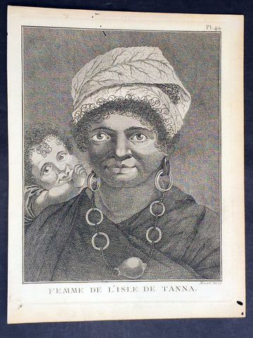
1778 Capt. Cook Antique Print Portrait of a Woman of Tanna Isle, Vanuatu in 1774
- Title : Femme De L Isle de Tanna
- Ref : 31782
- Size: 10in x 8in (255mm x 205mm)
- Date : 1778
- Condition: (A+) Fine Condition
Description:
This fine original copper-plate engraved antique print, a portrait of a Woman & Child of the Island of Tanna in the Vanuatu group of Islands in the South Pacific, visited by Captain James Cook during his 2nd Voyage of Discovery in the South Seas in 1774, was engraved by Robert Benard - after William Hodges - and was published in the 1778 French edition of Capt. James Cooks 2nd Voyage of Discovery to the South Seas A voyage towards the South Pole, and round the World. Performed in His Majestys ships the Resolution and Adventure, in the years 1772, 1773, 1774, and 1775..... Paris : Hotel de Thou ......1778
Cook Diary, 6-20th August 1774
........the Women have all the same ornaments as Men, Nose-Stones, Earrings, Shells on the Breast & Bracelets...their heads covered with a kind of cap made of a Plantain leaf or a Mat-Basket. Few are covered, & even very young Girls have these Caps.......Cooks Journal II
General Definitions:
Paper thickness and quality: - Heavy and stable
Paper color : - off white
Age of map color: -
Colors used: -
General color appearance: -
Paper size: - 10in x 8in (255mm x 205mm)
Plate size: - 9 1/2in x 7 1/4in (240mm x 185mm)
Margins: - Min 1/2in (12mm)
Imperfections:
Margins: - Light soiling in margins
Plate area: - None
Verso: - None
Background:
Tanna (sometimes spelled Tana) is an island in Tafea Province of Vanuatu.
Tanna was first settled about 400 BC by Melanesians from the surrounding islands. The glowing light of Mount Yasur attracted James Cook, the first European to visit the island, in August 1774, where he landed in an inlet on the southeastern tip of the island that he named Port Resolution after his ship HMS Resolution. He gave the island the name of Tanna, probably from the local name for earth, tana in the Kwamera language.
Vanuatu is a Pacific island nation located in the South Pacific Ocean. The archipelago, which is of volcanic origin, is 1,750 kilometres east of northern Australia, 540 kilometres northeast of New Caledonia, east of New Guinea, southeast of the Solomon Islands, and west of Fiji.
The Vanuatu group of islands first had contact with Europeans in 1606, when the Portuguese explorer Pedro Fernandes de Queirós, sailing for the Spanish Crown, arrived on the largest island and called the group of islands La Austrialia del Espiritu Santo or The Southern Land of the Holy Spirit, believing he had arrived in Terra Australis or Australia. The Spanish established a short-lived settlement at Big Bay on the north side of the island. The name Espiritu Santo remains to this day.
Europeans did not return until 1768, when Louis Antoine de Bougainville rediscovered the islands on 22 May, naming them the Great Cyclades. In 1774, Captain Cook named the islands the New Hebrides, a name that would last until independence in 1980.
William Hodges RA 1744 – 1797 was an English painter. He was a member of James Cooks second voyage to the Pacific Ocean, and is best known for the sketches and paintings of locations he visited on that voyage, including Table Bay, Tahiti, Easter Island, and the Antarctic.
Between 1772 and 1775 Hodges accompanied James Cook to the Pacific as the expeditions artist. Many of his sketches and wash paintings were adapted as engravings in the original published edition of Cooks journals from the voyage.
Most of the large-scale landscape oil paintings from his Pacific travels for which Hodges is best known were finished after his return to London; he received a salary from the Admiralty for the purposes of completing them. These paintings depicted a stronger light and shadow than had been usual in European landscape tradition. Contemporary art critics complained that his use of light and colour contrasts gave his paintings a rough and unfinished appearance.
Hodges also produced many valuable portrait sketches of Pacific islanders and scenes from the voyage involving members of the expedition..
Robert Bénard 1734 – 1777 was an 18th-century French engraver.
Specialized in the technique of engraving, Robert Ménard is mainly famous for having supplied a significant amount of plates (at least 1,800) to the Encyclopédie by Diderot & d\'Alembert from 1751.
Later, publisher Charles-Joseph Panckoucke reused many of his productions to illustrate the works of his catalog.
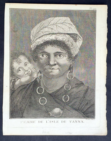
1778 Capt. Cook Antique Print Portrait of a Woman of Tanna Isle, Vanuatu in 1774
- Title : Femme De L Isle de Tanna
- Ref : 21354
- Size: 10in x 8in (255mm x 205mm)
- Date : 1778
- Condition: (A+) Fine Condition
Description:
This fine original copper-plate engraved antique print, a portrait of a Woman & Child of the Island of Tanna in the Vanuatu group of Islands in the South Pacific, visited by Captain James Cook during his 2nd Voyage of Discovery in the South Seas in 1774, was engraved by Robert Benard - after William Hodges - and was published in the 1778 French edition of Capt. James Cooks 2nd Voyage of Discovery to the South Seas A voyage towards the South Pole, and round the World. Performed in His Majestys ships the Resolution and Adventure, in the years 1772, 1773, 1774, and 1775..... Paris : Hotel de Thou ......1778
Cook Diary, 6-20th August 1774
........the Women have all the same ornaments as Men, Nose-Stones, Earrings, Shells on the Breast & Bracelets...their heads covered with a kind of cap made of a Plantain leaf or a Mat-Basket. Few are covered, & even very young Girls have these Caps.......Cooks Journal II
General Definitions:
Paper thickness and quality: - Heavy and stable
Paper color : - off white
Age of map color: -
Colors used: -
General color appearance: -
Paper size: - 10in x 8in (255mm x 205mm)
Plate size: - 9 1/2in x 7 1/4in (240mm x 185mm)
Margins: - Min 1/2in (12mm)
Imperfections:
Margins: - Light soiling in margins
Plate area: - None
Verso: - None
Background:
Tanna (sometimes spelled Tana) is an island in Tafea Province of Vanuatu.
Tanna was first settled about 400 BC by Melanesians from the surrounding islands. The glowing light of Mount Yasur attracted James Cook, the first European to visit the island, in August 1774, where he landed in an inlet on the southeastern tip of the island that he named Port Resolution after his ship HMS Resolution. He gave the island the name of Tanna, probably from the local name for earth, tana in the Kwamera language.
Vanuatu is a Pacific island nation located in the South Pacific Ocean. The archipelago, which is of volcanic origin, is 1,750 kilometres east of northern Australia, 540 kilometres northeast of New Caledonia, east of New Guinea, southeast of the Solomon Islands, and west of Fiji.
The Vanuatu group of islands first had contact with Europeans in 1606, when the Portuguese explorer Pedro Fernandes de Queirós, sailing for the Spanish Crown, arrived on the largest island and called the group of islands La Austrialia del Espiritu Santo or The Southern Land of the Holy Spirit, believing he had arrived in Terra Australis or Australia. The Spanish established a short-lived settlement at Big Bay on the north side of the island. The name Espiritu Santo remains to this day.
Europeans did not return until 1768, when Louis Antoine de Bougainville rediscovered the islands on 22 May, naming them the Great Cyclades. In 1774, Captain Cook named the islands the New Hebrides, a name that would last until independence in 1980.
William Hodges RA 1744 – 1797 was an English painter. He was a member of James Cooks second voyage to the Pacific Ocean, and is best known for the sketches and paintings of locations he visited on that voyage, including Table Bay, Tahiti, Easter Island, and the Antarctic.
Between 1772 and 1775 Hodges accompanied James Cook to the Pacific as the expeditions artist. Many of his sketches and wash paintings were adapted as engravings in the original published edition of Cooks journals from the voyage.
Most of the large-scale landscape oil paintings from his Pacific travels for which Hodges is best known were finished after his return to London; he received a salary from the Admiralty for the purposes of completing them. These paintings depicted a stronger light and shadow than had been usual in European landscape tradition. Contemporary art critics complained that his use of light and colour contrasts gave his paintings a rough and unfinished appearance.
Hodges also produced many valuable portrait sketches of Pacific islanders and scenes from the voyage involving members of the expedition..
Robert Bénard 1734 – 1777 was an 18th-century French engraver.
Specialized in the technique of engraving, Robert Ménard is mainly famous for having supplied a significant amount of plates (at least 1,800) to the Encyclopédie by Diderot & d\'Alembert from 1751.
Later, publisher Charles-Joseph Panckoucke reused many of his productions to illustrate the works of his catalog.
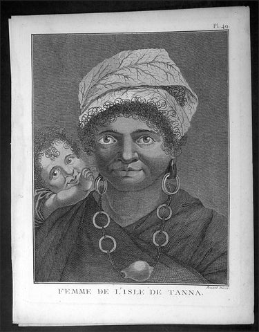
1778 Capt. Cook Antique Print Portrait of a Woman of Tanna Isle, Vanuatu in 1774
- Title : Femme De L Isle de Tanna
- Ref : 16354
- Size: 10in x 8in (255mm x 205mm)
- Date : 1778
- Condition: (A+) Fine Condition
Description:
This fine original copper-plate engraved antique print, a portrait of a Woman & Child of the Island of Tanna in the Vanuatu group of Islands in the South Pacific, visited by Captain James Cook during his 2nd Voyage of Discovery in the South Seas in 1774, was engraved by Robert Benard - after William Hodges - and was published in the 1778 French edition of Capt. James Cooks 2nd Voyage of Discovery to the South Seas A voyage towards the South Pole, and round the World. Performed in His Majestys ships the Resolution and Adventure, in the years 1772, 1773, 1774, and 1775..... Paris : Hotel de Thou ......1778
Cook Diary, 6-20th August 1774
........the Women have all the same ornaments as Men, Nose-Stones, Earrings, Shells on the Breast & Bracelets...their heads covered with a kind of cap made of a Plantain leaf or a Mat-Basket. Few are covered, & even very young Girls have these Caps.......Cooks Journal II
General Definitions:
Paper thickness and quality: - Heavy and stable
Paper color : - off white
Age of map color: -
Colors used: -
General color appearance: -
Paper size: - 10in x 8in (255mm x 205mm)
Plate size: - 9 1/2in x 7 1/4in (240mm x 185mm)
Margins: - Min 1/2in (12mm)
Imperfections:
Margins: - Light soiling in margins
Plate area: - None
Verso: - None
Background:
Tanna (sometimes spelled Tana) is an island in Tafea Province of Vanuatu.
Tanna was first settled about 400 BC by Melanesians from the surrounding islands. The glowing light of Mount Yasur attracted James Cook, the first European to visit the island, in August 1774, where he landed in an inlet on the southeastern tip of the island that he named Port Resolution after his ship HMS Resolution. He gave the island the name of Tanna, probably from the local name for earth, tana in the Kwamera language.
Vanuatu is a Pacific island nation located in the South Pacific Ocean. The archipelago, which is of volcanic origin, is 1,750 kilometres east of northern Australia, 540 kilometres northeast of New Caledonia, east of New Guinea, southeast of the Solomon Islands, and west of Fiji.
The Vanuatu group of islands first had contact with Europeans in 1606, when the Portuguese explorer Pedro Fernandes de Queirós, sailing for the Spanish Crown, arrived on the largest island and called the group of islands La Austrialia del Espiritu Santo or The Southern Land of the Holy Spirit, believing he had arrived in Terra Australis or Australia. The Spanish established a short-lived settlement at Big Bay on the north side of the island. The name Espiritu Santo remains to this day.
Europeans did not return until 1768, when Louis Antoine de Bougainville rediscovered the islands on 22 May, naming them the Great Cyclades. In 1774, Captain Cook named the islands the New Hebrides, a name that would last until independence in 1980.
William Hodges RA 1744 – 1797 was an English painter. He was a member of James Cooks second voyage to the Pacific Ocean, and is best known for the sketches and paintings of locations he visited on that voyage, including Table Bay, Tahiti, Easter Island, and the Antarctic.
Between 1772 and 1775 Hodges accompanied James Cook to the Pacific as the expeditions artist. Many of his sketches and wash paintings were adapted as engravings in the original published edition of Cooks journals from the voyage.
Most of the large-scale landscape oil paintings from his Pacific travels for which Hodges is best known were finished after his return to London; he received a salary from the Admiralty for the purposes of completing them. These paintings depicted a stronger light and shadow than had been usual in European landscape tradition. Contemporary art critics complained that his use of light and colour contrasts gave his paintings a rough and unfinished appearance.
Hodges also produced many valuable portrait sketches of Pacific islanders and scenes from the voyage involving members of the expedition..
Robert Bénard 1734 – 1777 was an 18th-century French engraver.
Specialized in the technique of engraving, Robert Ménard is mainly famous for having supplied a significant amount of plates (at least 1,800) to the Encyclopédie by Diderot & d\'Alembert from 1751.
Later, publisher Charles-Joseph Panckoucke reused many of his productions to illustrate the works of his catalog.
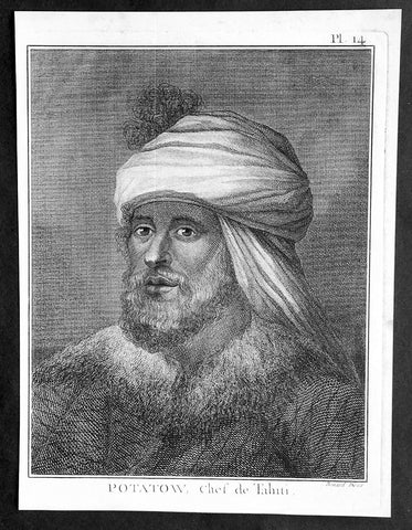
1778 Capt. Cook Antique Print Portrait of Chief Potatau of Punaauia, Tahiti 1773
- Title : Potatow, Chef de Tahiti
- Ref : 31772
- Size: 10in x 8in (255mm x 205mm)
- Date : 1778
- Condition: (A+) Fine Condition
Description:
This fine original copper-plate engraved antique print, a portrait of Chief Potatau of Punaauia in Tahiti, French Polynesia, met by Captain James Cook during his 2nd Voyage of Discovery in the South Seas in 1773, was engraved by Robert Benard - after William Hodges - and was published in the 1778 French edition of Capt. James Cooks 2nd Voyage of Discovery to the South Seas A voyage towards the South Pole, and round the World. Performed in His Majestys ships the Resolution and Adventure, in the years 1772, 1773, 1774, and 1775..... Paris : Hotel de Thou ......1778
Cooks Biography............George Vancouver (midshipman, of later fame) meanwhile, stayed behind to contemplate the role of the red feather in Tahitian society. It happened that Chief Potatau consulted with his wife on how they might obtain some of Cook\'s Oora and according to the plan that somehow reached Georges ears, she would go to Cook in his cabin and offer her services in return for said feathers. But the Captain was unswayed. It was just as well that Georges father was absent on this particular occasion, for he would only have been upset. As it was, his sleep was often disturbed by the sailors running all over the ship with their sexual partners at any hour of the night.
Such was Tahitian zeal for red feathers, Clerke remarked, that they gladly engaged in rather unhallow\'d rites for the sacred jewels in order to offer Propitiation to their Jolly Gods. Such was the maritime zeal for the Tahitian religion that the sailors fairly plundered the ship of its treasures; feathers were ripped from lovely Tongan garments and from delicate fretwork on coconuts; sailors even dyed plain feathers red. Thus valuable artifacts of the South Seas were undone. Nevertheless, among the treasures that came aboard were Potatau\'s monstrous helmets of war of five feet high and several handsome mourning dresses to become in due course part of the collections of ethnology in the Ashmolean Museum and the Bishop Museum. Besides the red feathers, the abundance of pork also attracted the girls; they consumed incredible quantities, reported George, because, as members of a poor class of Tahitians, they were denied pork in their own households. Such were the quantities they consumed, added George with a certain delicacy, that of a sudden they suffered the inconvenience of restlessness, and when they were refused the attention of their lovers, the very decks began to resemble the paths in the islands.........
General Definitions:
Paper thickness and quality: - Heavy and stable
Paper color : - off white
Age of map color: -
Colors used: -
General color appearance: -
Paper size: - 10in x 8in (255mm x 205mm)
Plate size: - 9 1/2in x 7 1/4in (240mm x 185mm)
Margins: - Min 1/2in (12mm)
Imperfections:
Margins: - Light soiling in margins
Plate area: - None
Verso: - None
Background:
Tahiti previously also known as Otaheite is the largest island in the Windward group of French Polynesia. The island is located in the archipelago of the Society Islands in the central Southern Pacific Ocean.
The first European to have visited Tahiti according to existing records was lieutenant Samuel Wallis, who was circumnavigating the globe in HMS Dolphin, sighting the island on 18 June 1767, and eventually harboring in Matavai Bay. This bay was situated on the territory of the chiefdom of Pare-Arue, governed by Tu (Tu-nui-e-a a-i-te-Atua) and his regent Tutaha, and the chiefdom of Ha apape, governed by Amo and his wife Oberea (Purea). Wallis named the island King Georges Island. The first contacts were difficult, since on the 24 and 26 June 1767, Tahitian warriors in canoes showed aggression towards the British, hurling stones from their slings. In retaliation, the British sailors opened fire on the warriors in the canoes and on the hills. In reaction to this powerful counter-attack, the Tahitians laid down peace offerings for the British. Following this episode, Samuel Wallis was able to establish cordial relations with the female chieftain “Oberea “ (Purea) and remained on the island until 27 July 1767.
In July 1768, Captain James Cook was commissioned by the Royal Society and on orders from the Lords Commissioners of the Admiralty to observe the transit of Venus across the sun, a phenomenon that would be visible from Tahiti on 3 June 1769. He arrived in Tahitis Matavai Bay, commanding the HMS Endeavour on 12 April 1769. On 14 April, Cook met with Tutaha and Tepau. On 15 April, Cook picked the site for a fortified camp at Point Venus along with Banks, Parkinson, Daniel Solander, to protect Charles Greens observatory. The length of stay enabled them to undertake for the first time real ethnographic and scientific observations of the island. Assisted by the botanist Joseph Banks, and by the artist Sydney Parkinson, Cook gathered valuable information on the fauna and flora, as well as the native society, language and customs, including the proper name of the island, Otaheite. On 28 April, Cook met Purea and Tupaia, and Tupaia befriended Banks following the transit. On 21 June, Amo visited Cook, and then on 25 June, Pohuetea visited, signifying another chief seeking to ally himself with the British.
Cook and Banks circumnavigated the island from 26 June to 1 July. On the exploration, they met Ahio, chief of Ha apaiano o or Papenoo, Rita, chief of Hitia a, Pahairro, chief of Pueu, Vehiatua, chief of Tautra, Matahiapo, chief of Teahupo o, Tutea, chief of Vaira o, and Moe, chief of Afa Ahiti. In Papara, guided by Tupaia, they investigated the ruins of Mahaiatea marae, an impressive structure containing a stone pyramid or ahu, measuring 44 feet high, 267 feet long and 87 feet wide. Cook and the Endeavour departed Tahiti on 13 July 1769, taking Raiatean navigator Tupaia along for his geographic knowledge of the islands.
Cook returned to Tahiti between 15 August and 1 September 1773, greeted by the chiefs Tai and Puhi, besides the youg ari i Vehiatua II and his stepfather Ti itorea. Cook anchored in Vaitepiha Bay before returning to Point Venus where he met Tu, the paramount chief. Cook picked up two passengers from Tahiti during this trip, Porea and Mai, with Hitihiti later replacing Porea when Cook stopped at Raiatea. Cook took Hitihiti to Tahiti on 22 April, during his return leg. Then, Cook departed Tahiti on 14 May 1774.
During his final visit, Cook returned Mai to Tahiti on 12 Aug. 1777, after Mais long visit in England. Cook also brought two Maori from Queen Charlotte Sound, Te Weherua and Koa. Cook first harbored in Vaitepiha Bay, where he visited Vehiatua II s funeral bier and the prefabricated Spanish mission house. Cook also met Vehiatua III, and inscribed on the back of the Spanish cross, Georgius tertius Rex Annis 1767, 69, 73, 74 & 77, as a counterpoint to Christus Vincit Carolus III imperat 1774 on the front. On 23 Aug., Cook sailed for Matavai Bay, where he met Tu, his father Teu, his mother Tetupaia, his brothers Ari ipaea and Vaetua, and his sisters Ari ipaea-vahine, Tetua-te-ahamai, and Auo. Cook also observed a human sacrifice, taata tapu, at the Utu-ai-mahurau marae, and 49 skulls from previous victims.
On 29 Sept. 1777, Cook sailed for Papetoai Bay on Moorea. Cook met Mahine in an act of friendship on 3 Oct., though he was an enemy of Tu. When a goat kid was stolen on 6 Oct., Cook in a rampage, ordered the burning of houses and canoes until it was returned. Cook sailed for Huahine on 11 Oct., Raiatea on 2 Nov., and Borabora on 7 Dec.
On 26 October 1788, HMS Bounty, under the command of Captain William Bligh, landed in Tahiti with the mission of carrying Tahitian breadfruit trees (Tahitian: uru) to the Caribbean. Sir Joseph Banks, the botanist from James Cooks first expedition, had concluded that this plant would be ideal to feed the African slaves working in the Caribbean plantations at very little cost. The crew remained in Tahiti for about five months, the time needed to transplant the seedlings of the trees. Three weeks after leaving Tahiti, on 28 April 1789, the crew mutinied on the initiative of Fletcher Christian. The mutineers seized the ship and set the captain and most of those members of the crew who remained loyal to him adrift in a ships boat. A group of mutineers then went back to settle in Tahiti.
Although various explorers had refused to get involved in tribal conflicts, the mutineers from the Bounty offered their services as mercenaries and furnished arms to the family which became the Pōmare Dynasty. The chief Tū knew how to use their presence in the harbours favoured by sailors to his advantage. As a result of his alliance with the mutineers, he succeeded in considerably increasing his supremacy over the island of Tahiti.
William Hodges RA 1744 – 1797 was an English painter. He was a member of James Cooks second voyage to the Pacific Ocean, and is best known for the sketches and paintings of locations he visited on that voyage, including Table Bay, Tahiti, Easter Island, and the Antarctic.
Between 1772 and 1775 Hodges accompanied James Cook to the Pacific as the expeditions artist. Many of his sketches and wash paintings were adapted as engravings in the original published edition of Cooks journals from the voyage.
Most of the large-scale landscape oil paintings from his Pacific travels for which Hodges is best known were finished after his return to London; he received a salary from the Admiralty for the purposes of completing them. These paintings depicted a stronger light and shadow than had been usual in European landscape tradition. Contemporary art critics complained that his use of light and colour contrasts gave his paintings a rough and unfinished appearance.
Hodges also produced many valuable portrait sketches of Pacific islanders and scenes from the voyage involving members of the expedition..
Robert Bénard 1734 – 1777 was an 18th-century French engraver.
Specialized in the technique of engraving, Robert Ménard is mainly famous for having supplied a significant amount of plates (at least 1,800) to the Encyclopédie by Diderot & d\'Alembert from 1751.
Later, publisher Charles-Joseph Panckoucke reused many of his productions to illustrate the works of his catalog.
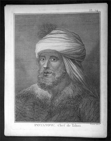
1778 Capt. Cook Antique Print Portrait of Chief Potatau of Punaauia, Tahiti 1773
- Title : Potatow, Chef de Tahiti
- Ref : 16353
- Size: 10in x 8in (255mm x 205mm)
- Date : 1778
- Condition: (A+) Fine Condition
Description:
This fine original copper-plate engraved antique print, a portrait of Chief Potatau of Punaauia in Tahiti, French Polynesia, met by Captain James Cook during his 2nd Voyage of Discovery in the South Seas in 1773, was engraved by Robert Benard - after William Hodges - and was published in the 1778 French edition of Capt. James Cooks 2nd Voyage of Discovery to the South Seas A voyage towards the South Pole, and round the World. Performed in His Majestys ships the Resolution and Adventure, in the years 1772, 1773, 1774, and 1775..... Paris : Hotel de Thou ......1778
Cooks Biography............George Vancouver (midshipman, of later fame) meanwhile, stayed behind to contemplate the role of the red feather in Tahitian society. It happened that Chief Potatau consulted with his wife on how they might obtain some of Cook\'s Oora and according to the plan that somehow reached Georges ears, she would go to Cook in his cabin and offer her services in return for said feathers. But the Captain was unswayed. It was just as well that Georges father was absent on this particular occasion, for he would only have been upset. As it was, his sleep was often disturbed by the sailors running all over the ship with their sexual partners at any hour of the night.
Such was Tahitian zeal for red feathers, Clerke remarked, that they gladly engaged in rather unhallow\'d rites for the sacred jewels in order to offer Propitiation to their Jolly Gods. Such was the maritime zeal for the Tahitian religion that the sailors fairly plundered the ship of its treasures; feathers were ripped from lovely Tongan garments and from delicate fretwork on coconuts; sailors even dyed plain feathers red. Thus valuable artifacts of the South Seas were undone. Nevertheless, among the treasures that came aboard were Potatau\'s monstrous helmets of war of five feet high and several handsome mourning dresses to become in due course part of the collections of ethnology in the Ashmolean Museum and the Bishop Museum. Besides the red feathers, the abundance of pork also attracted the girls; they consumed incredible quantities, reported George, because, as members of a poor class of Tahitians, they were denied pork in their own households. Such were the quantities they consumed, added George with a certain delicacy, that of a sudden they suffered the inconvenience of restlessness, and when they were refused the attention of their lovers, the very decks began to resemble the paths in the islands.........
General Definitions:
Paper thickness and quality: - Heavy and stable
Paper color : - off white
Age of map color: -
Colors used: -
General color appearance: -
Paper size: - 10in x 8in (255mm x 205mm)
Plate size: - 9 1/2in x 7 1/4in (240mm x 185mm)
Margins: - Min 1/2in (12mm)
Imperfections:
Margins: - Light soiling in margins
Plate area: - None
Verso: - None
Background:
Tahiti previously also known as Otaheite is the largest island in the Windward group of French Polynesia. The island is located in the archipelago of the Society Islands in the central Southern Pacific Ocean.
The first European to have visited Tahiti according to existing records was lieutenant Samuel Wallis, who was circumnavigating the globe in HMS Dolphin, sighting the island on 18 June 1767, and eventually harboring in Matavai Bay. This bay was situated on the territory of the chiefdom of Pare-Arue, governed by Tu (Tu-nui-e-a a-i-te-Atua) and his regent Tutaha, and the chiefdom of Ha apape, governed by Amo and his wife Oberea (Purea). Wallis named the island King Georges Island. The first contacts were difficult, since on the 24 and 26 June 1767, Tahitian warriors in canoes showed aggression towards the British, hurling stones from their slings. In retaliation, the British sailors opened fire on the warriors in the canoes and on the hills. In reaction to this powerful counter-attack, the Tahitians laid down peace offerings for the British. Following this episode, Samuel Wallis was able to establish cordial relations with the female chieftain “Oberea “ (Purea) and remained on the island until 27 July 1767.
In July 1768, Captain James Cook was commissioned by the Royal Society and on orders from the Lords Commissioners of the Admiralty to observe the transit of Venus across the sun, a phenomenon that would be visible from Tahiti on 3 June 1769. He arrived in Tahitis Matavai Bay, commanding the HMS Endeavour on 12 April 1769. On 14 April, Cook met with Tutaha and Tepau. On 15 April, Cook picked the site for a fortified camp at Point Venus along with Banks, Parkinson, Daniel Solander, to protect Charles Greens observatory. The length of stay enabled them to undertake for the first time real ethnographic and scientific observations of the island. Assisted by the botanist Joseph Banks, and by the artist Sydney Parkinson, Cook gathered valuable information on the fauna and flora, as well as the native society, language and customs, including the proper name of the island, Otaheite. On 28 April, Cook met Purea and Tupaia, and Tupaia befriended Banks following the transit. On 21 June, Amo visited Cook, and then on 25 June, Pohuetea visited, signifying another chief seeking to ally himself with the British.
Cook and Banks circumnavigated the island from 26 June to 1 July. On the exploration, they met Ahio, chief of Ha apaiano o or Papenoo, Rita, chief of Hitia a, Pahairro, chief of Pueu, Vehiatua, chief of Tautra, Matahiapo, chief of Teahupo o, Tutea, chief of Vaira o, and Moe, chief of Afa Ahiti. In Papara, guided by Tupaia, they investigated the ruins of Mahaiatea marae, an impressive structure containing a stone pyramid or ahu, measuring 44 feet high, 267 feet long and 87 feet wide. Cook and the Endeavour departed Tahiti on 13 July 1769, taking Raiatean navigator Tupaia along for his geographic knowledge of the islands.
Cook returned to Tahiti between 15 August and 1 September 1773, greeted by the chiefs Tai and Puhi, besides the youg ari i Vehiatua II and his stepfather Ti itorea. Cook anchored in Vaitepiha Bay before returning to Point Venus where he met Tu, the paramount chief. Cook picked up two passengers from Tahiti during this trip, Porea and Mai, with Hitihiti later replacing Porea when Cook stopped at Raiatea. Cook took Hitihiti to Tahiti on 22 April, during his return leg. Then, Cook departed Tahiti on 14 May 1774.
During his final visit, Cook returned Mai to Tahiti on 12 Aug. 1777, after Mais long visit in England. Cook also brought two Maori from Queen Charlotte Sound, Te Weherua and Koa. Cook first harbored in Vaitepiha Bay, where he visited Vehiatua II s funeral bier and the prefabricated Spanish mission house. Cook also met Vehiatua III, and inscribed on the back of the Spanish cross, Georgius tertius Rex Annis 1767, 69, 73, 74 & 77, as a counterpoint to Christus Vincit Carolus III imperat 1774 on the front. On 23 Aug., Cook sailed for Matavai Bay, where he met Tu, his father Teu, his mother Tetupaia, his brothers Ari ipaea and Vaetua, and his sisters Ari ipaea-vahine, Tetua-te-ahamai, and Auo. Cook also observed a human sacrifice, taata tapu, at the Utu-ai-mahurau marae, and 49 skulls from previous victims.
On 29 Sept. 1777, Cook sailed for Papetoai Bay on Moorea. Cook met Mahine in an act of friendship on 3 Oct., though he was an enemy of Tu. When a goat kid was stolen on 6 Oct., Cook in a rampage, ordered the burning of houses and canoes until it was returned. Cook sailed for Huahine on 11 Oct., Raiatea on 2 Nov., and Borabora on 7 Dec.
On 26 October 1788, HMS Bounty, under the command of Captain William Bligh, landed in Tahiti with the mission of carrying Tahitian breadfruit trees (Tahitian: uru) to the Caribbean. Sir Joseph Banks, the botanist from James Cooks first expedition, had concluded that this plant would be ideal to feed the African slaves working in the Caribbean plantations at very little cost. The crew remained in Tahiti for about five months, the time needed to transplant the seedlings of the trees. Three weeks after leaving Tahiti, on 28 April 1789, the crew mutinied on the initiative of Fletcher Christian. The mutineers seized the ship and set the captain and most of those members of the crew who remained loyal to him adrift in a ships boat. A group of mutineers then went back to settle in Tahiti.
Although various explorers had refused to get involved in tribal conflicts, the mutineers from the Bounty offered their services as mercenaries and furnished arms to the family which became the Pōmare Dynasty. The chief Tū knew how to use their presence in the harbours favoured by sailors to his advantage. As a result of his alliance with the mutineers, he succeeded in considerably increasing his supremacy over the island of Tahiti.
William Hodges RA 1744 – 1797 was an English painter. He was a member of James Cooks second voyage to the Pacific Ocean, and is best known for the sketches and paintings of locations he visited on that voyage, including Table Bay, Tahiti, Easter Island, and the Antarctic.
Between 1772 and 1775 Hodges accompanied James Cook to the Pacific as the expeditions artist. Many of his sketches and wash paintings were adapted as engravings in the original published edition of Cooks journals from the voyage.
Most of the large-scale landscape oil paintings from his Pacific travels for which Hodges is best known were finished after his return to London; he received a salary from the Admiralty for the purposes of completing them. These paintings depicted a stronger light and shadow than had been usual in European landscape tradition. Contemporary art critics complained that his use of light and colour contrasts gave his paintings a rough and unfinished appearance.
Hodges also produced many valuable portrait sketches of Pacific islanders and scenes from the voyage involving members of the expedition..
Robert Bénard 1734 – 1777 was an 18th-century French engraver.
Specialized in the technique of engraving, Robert Ménard is mainly famous for having supplied a significant amount of plates (at least 1,800) to the Encyclopédie by Diderot & d\'Alembert from 1751.
Later, publisher Charles-Joseph Panckoucke reused many of his productions to illustrate the works of his catalog.
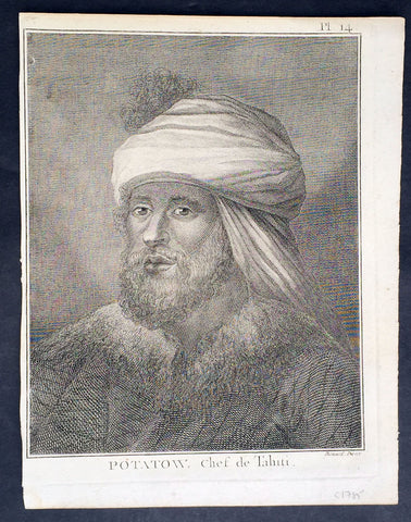
1778 Capt. Cook Antique Print Portrait of Chief Potatau of Punaauia, Tahiti 1773
- Title : Potatow, Chef de Tahiti
- Ref : 21415
- Size: 10in x 8in (255mm x 205mm)
- Date : 1778
- Condition: (A+) Fine Condition
Description:
This fine original copper-plate engraved antique print, a portrait of Chief Potatau of Punaauia in Tahiti, French Polynesia, met by Captain James Cook during his 2nd Voyage of Discovery in the South Seas in 1773, was engraved by Robert Benard - after William Hodges - and was published in the 1778 French edition of Capt. James Cooks 2nd Voyage of Discovery to the South Seas A voyage towards the South Pole, and round the World. Performed in His Majestys ships the Resolution and Adventure, in the years 1772, 1773, 1774, and 1775..... Paris : Hotel de Thou ......1778
Cooks Biography............George Vancouver (midshipman, of later fame) meanwhile, stayed behind to contemplate the role of the red feather in Tahitian society. It happened that Chief Potatau consulted with his wife on how they might obtain some of Cook\'s Oora and according to the plan that somehow reached Georges ears, she would go to Cook in his cabin and offer her services in return for said feathers. But the Captain was unswayed. It was just as well that Georges father was absent on this particular occasion, for he would only have been upset. As it was, his sleep was often disturbed by the sailors running all over the ship with their sexual partners at any hour of the night.
Such was Tahitian zeal for red feathers, Clerke remarked, that they gladly engaged in rather unhallow\'d rites for the sacred jewels in order to offer Propitiation to their Jolly Gods. Such was the maritime zeal for the Tahitian religion that the sailors fairly plundered the ship of its treasures; feathers were ripped from lovely Tongan garments and from delicate fretwork on coconuts; sailors even dyed plain feathers red. Thus valuable artifacts of the South Seas were undone. Nevertheless, among the treasures that came aboard were Potatau\'s monstrous helmets of war of five feet high and several handsome mourning dresses to become in due course part of the collections of ethnology in the Ashmolean Museum and the Bishop Museum. Besides the red feathers, the abundance of pork also attracted the girls; they consumed incredible quantities, reported George, because, as members of a poor class of Tahitians, they were denied pork in their own households. Such were the quantities they consumed, added George with a certain delicacy, that of a sudden they suffered the inconvenience of restlessness, and when they were refused the attention of their lovers, the very decks began to resemble the paths in the islands.........
General Definitions:
Paper thickness and quality: - Heavy and stable
Paper color : - off white
Age of map color: -
Colors used: -
General color appearance: -
Paper size: - 10in x 8in (255mm x 205mm)
Plate size: - 9 1/2in x 7 1/4in (240mm x 185mm)
Margins: - Min 1/2in (12mm)
Imperfections:
Margins: - Light soiling in margins
Plate area: - None
Verso: - None
Background:
Tahiti previously also known as Otaheite is the largest island in the Windward group of French Polynesia. The island is located in the archipelago of the Society Islands in the central Southern Pacific Ocean.
The first European to have visited Tahiti according to existing records was lieutenant Samuel Wallis, who was circumnavigating the globe in HMS Dolphin, sighting the island on 18 June 1767, and eventually harboring in Matavai Bay. This bay was situated on the territory of the chiefdom of Pare-Arue, governed by Tu (Tu-nui-e-a a-i-te-Atua) and his regent Tutaha, and the chiefdom of Ha apape, governed by Amo and his wife Oberea (Purea). Wallis named the island King Georges Island. The first contacts were difficult, since on the 24 and 26 June 1767, Tahitian warriors in canoes showed aggression towards the British, hurling stones from their slings. In retaliation, the British sailors opened fire on the warriors in the canoes and on the hills. In reaction to this powerful counter-attack, the Tahitians laid down peace offerings for the British. Following this episode, Samuel Wallis was able to establish cordial relations with the female chieftain “Oberea “ (Purea) and remained on the island until 27 July 1767.
In July 1768, Captain James Cook was commissioned by the Royal Society and on orders from the Lords Commissioners of the Admiralty to observe the transit of Venus across the sun, a phenomenon that would be visible from Tahiti on 3 June 1769. He arrived in Tahitis Matavai Bay, commanding the HMS Endeavour on 12 April 1769. On 14 April, Cook met with Tutaha and Tepau. On 15 April, Cook picked the site for a fortified camp at Point Venus along with Banks, Parkinson, Daniel Solander, to protect Charles Greens observatory. The length of stay enabled them to undertake for the first time real ethnographic and scientific observations of the island. Assisted by the botanist Joseph Banks, and by the artist Sydney Parkinson, Cook gathered valuable information on the fauna and flora, as well as the native society, language and customs, including the proper name of the island, Otaheite. On 28 April, Cook met Purea and Tupaia, and Tupaia befriended Banks following the transit. On 21 June, Amo visited Cook, and then on 25 June, Pohuetea visited, signifying another chief seeking to ally himself with the British.
Cook and Banks circumnavigated the island from 26 June to 1 July. On the exploration, they met Ahio, chief of Ha apaiano o or Papenoo, Rita, chief of Hitia a, Pahairro, chief of Pueu, Vehiatua, chief of Tautra, Matahiapo, chief of Teahupo o, Tutea, chief of Vaira o, and Moe, chief of Afa Ahiti. In Papara, guided by Tupaia, they investigated the ruins of Mahaiatea marae, an impressive structure containing a stone pyramid or ahu, measuring 44 feet high, 267 feet long and 87 feet wide. Cook and the Endeavour departed Tahiti on 13 July 1769, taking Raiatean navigator Tupaia along for his geographic knowledge of the islands.
Cook returned to Tahiti between 15 August and 1 September 1773, greeted by the chiefs Tai and Puhi, besides the youg ari i Vehiatua II and his stepfather Ti itorea. Cook anchored in Vaitepiha Bay before returning to Point Venus where he met Tu, the paramount chief. Cook picked up two passengers from Tahiti during this trip, Porea and Mai, with Hitihiti later replacing Porea when Cook stopped at Raiatea. Cook took Hitihiti to Tahiti on 22 April, during his return leg. Then, Cook departed Tahiti on 14 May 1774.
During his final visit, Cook returned Mai to Tahiti on 12 Aug. 1777, after Mais long visit in England. Cook also brought two Maori from Queen Charlotte Sound, Te Weherua and Koa. Cook first harbored in Vaitepiha Bay, where he visited Vehiatua II s funeral bier and the prefabricated Spanish mission house. Cook also met Vehiatua III, and inscribed on the back of the Spanish cross, Georgius tertius Rex Annis 1767, 69, 73, 74 & 77, as a counterpoint to Christus Vincit Carolus III imperat 1774 on the front. On 23 Aug., Cook sailed for Matavai Bay, where he met Tu, his father Teu, his mother Tetupaia, his brothers Ari ipaea and Vaetua, and his sisters Ari ipaea-vahine, Tetua-te-ahamai, and Auo. Cook also observed a human sacrifice, taata tapu, at the Utu-ai-mahurau marae, and 49 skulls from previous victims.
On 29 Sept. 1777, Cook sailed for Papetoai Bay on Moorea. Cook met Mahine in an act of friendship on 3 Oct., though he was an enemy of Tu. When a goat kid was stolen on 6 Oct., Cook in a rampage, ordered the burning of houses and canoes until it was returned. Cook sailed for Huahine on 11 Oct., Raiatea on 2 Nov., and Borabora on 7 Dec.
On 26 October 1788, HMS Bounty, under the command of Captain William Bligh, landed in Tahiti with the mission of carrying Tahitian breadfruit trees (Tahitian: uru) to the Caribbean. Sir Joseph Banks, the botanist from James Cooks first expedition, had concluded that this plant would be ideal to feed the African slaves working in the Caribbean plantations at very little cost. The crew remained in Tahiti for about five months, the time needed to transplant the seedlings of the trees. Three weeks after leaving Tahiti, on 28 April 1789, the crew mutinied on the initiative of Fletcher Christian. The mutineers seized the ship and set the captain and most of those members of the crew who remained loyal to him adrift in a ships boat. A group of mutineers then went back to settle in Tahiti.
Although various explorers had refused to get involved in tribal conflicts, the mutineers from the Bounty offered their services as mercenaries and furnished arms to the family which became the Pōmare Dynasty. The chief Tū knew how to use their presence in the harbours favoured by sailors to his advantage. As a result of his alliance with the mutineers, he succeeded in considerably increasing his supremacy over the island of Tahiti.
William Hodges RA 1744 – 1797 was an English painter. He was a member of James Cooks second voyage to the Pacific Ocean, and is best known for the sketches and paintings of locations he visited on that voyage, including Table Bay, Tahiti, Easter Island, and the Antarctic.
Between 1772 and 1775 Hodges accompanied James Cook to the Pacific as the expeditions artist. Many of his sketches and wash paintings were adapted as engravings in the original published edition of Cooks journals from the voyage.
Most of the large-scale landscape oil paintings from his Pacific travels for which Hodges is best known were finished after his return to London; he received a salary from the Admiralty for the purposes of completing them. These paintings depicted a stronger light and shadow than had been usual in European landscape tradition. Contemporary art critics complained that his use of light and colour contrasts gave his paintings a rough and unfinished appearance.
Hodges also produced many valuable portrait sketches of Pacific islanders and scenes from the voyage involving members of the expedition..
Robert Bénard 1734 – 1777 was an 18th-century French engraver.
Specialized in the technique of engraving, Robert Ménard is mainly famous for having supplied a significant amount of plates (at least 1,800) to the Encyclopédie by Diderot & d\'Alembert from 1751.
Later, publisher Charles-Joseph Panckoucke reused many of his productions to illustrate the works of his catalog.