Products
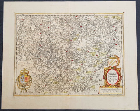
1619 Jansson Large Old, Antique Map of the Champagne Region of France
- Title : Champagne - Comitatus Campania
- Ref #: 50246
- Size: 24in x 19 1/2in (610mm x 495mm)
- Date : 1619
- Condition: (A+) Fine Condition
Description:
This large beautifully hand coloured original antique map of The Champagne region of France was published in the 1619 edition ofMercators Atlas published by Henricus Hondius and Jan Jansson.
The map centres on the city of Chalons east to Verdun, west to Troyes, north to Dormans and south to Chaumont. (Ref: Tooley, Koeman)
General Description:
Paper thickness and quality: - Heavy and stable
Paper color: - off white
Age of map color: - Early
Colors used: - Green, red, orange, yellow, blue
General color appearance: - Authentic
Paper size: - 24in x 19 1/2in (610mm x 495mm)
Plate size: - 20in x 15in (535mm x 380mm)
Margins: - Min 1in (25mm)
Imperfections:
Margins: - None
Plate area: - None
Verso: - None
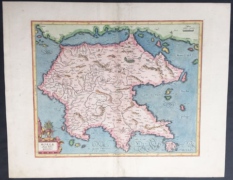
1623 Mercator Hondius Antique Map of Morea - the Greek Peloponnesus, Greece
- Title : Morea olim Piloponnesus
- Ref #: 35489
- Size: 21 1/2in x 17in (545mm x 430mm)
- Date : 1623
- Condition: (A+) Fine Condition
Description:
This beautifully hand coloured original antique map of Morea - the Greek Peloponnesus - was published in the 1623 ofMercators Atlas published by Henricus Hondius and Jan Jansson.
These maps, published in the later editions of Mercators atlas, are derived from the original maps drawn and engraved by Gerard Mercator in the mid to late 16th century, published by his son Rumold as an atlas, after his death, in 1595. After two editions the plates were purchased by Jodocus Hondius in 1604 and continued to be published until the mid 1630's when the plates were re-engraved and updated by Jan Jansson and Henricus Hondius.
Condition Report
Paper thickness and quality: - Heavy and stable
Paper color: - off white
Age of map color: - Original
Colors used: - Red, yellow, green
General color appearance: - Authentic
Paper size: - 21 1/2in x 17in (545mm x 430mm)
Plate size: - 16 1/2in x 13 1/2in (420mm x 345mm)
Margins: - Min 1in (25mm)
Imperfections:
Margins: - Light age toning
Plate area: - Light wear along centerfold
Verso: - Light colour bleed
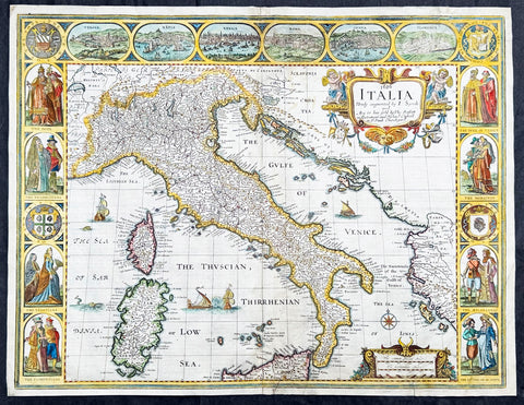
1626 (1676) John Speed Antique Map Italy Sardinia, Corsica, Sicily - Rare state
- Title : 1626 Italia Newly augmented by I. Speed and Are to bee Sold by Tho. Bassett in Fleet Street and Richard Chiswell in St. Puals Church-yard
- Date : 1626 (1676)
- Size: 21 1/4in x 16 1/4in (540mm x 410mm)
- Condition: (A-) Good Condition
- Ref: 35655
Description:
This original hand coloured copper plate engraved antique map of Italy by John Speed was published in the 1676 Bassett & Chiswell edition of Speeds famous atlas Prospect of the Most Famous Parts of the World.
A very unusual state, as far as I can tell unrecorded, with the date 1626 engraved in the title. This map was first published in 1626 with the date included at the end of the title. This map was published in 1676 by Bassett and Chiswell but for some reason the date, 1626 has been included at the top and beginning of the title, I have been unable to find another example.
General Definitions:
Paper thickness and quality: - Heavy and stable
Paper color : - off white
Age of map color: - Original
Colors used: - Yellow, green, blue, pink
General color appearance: - Authentic
Paper size: - 21 1/4in x 16 1/4in (540mm x 410mm)
Plate size: - 18 1/2in x 15 3/4in (470mm x 400mm)
Margins: - Min 1/2in (10mm)
Imperfections:
Margins: - Small section of top margin professionally restored about 1/2in into view of Florence
Plate area: - Two rejoins to bottom margin 1in into the border and map, no loss. Light fold bottom right corner
Verso: - Light soiling, repairs as noted
Background:
Since classical times the countries bordering the enclosed waters of the Mediterranean had been well versed in the use of maps and sea charts and in Italy, more than anywhere else, the traditional knowledge was kept alive during the many hundreds of years following the collapse of the Roman Empire. By the thirteenth and fourteenth centuries the seamen of Venice, Genoa and Amalfi traded to far countries, from the Black Sea ports and the coasts of Palestine and Egypt in the East to Flanders and the southern coasts of England and Ireland in the West, their voyages guided by portulan charts and the use of the newly invented compass. For a time Italian supremacy in cartography passed to Aragon and the Catalan map makers based on Majorca, but by the year 1400 the power and wealth of the city states of Venice, Genoa, Florence and Milan surpassed any in Europe. Florence, especially, under the rule of the Medici family, became not only a great trading and financial centre but also the focal point of the rediscovery of the arts and learning of the ancient world. In this milieu a number of manuscript world maps were produced, of which one by Fra Mauro (c. 1459) is the most notable, but the event of the greatest importance in the history of cartography occurred in the year 1400 when a Florentine, Palla Strozzi, brought from Constantinople a Greek manuscript copy of Claudius Ptolemy's Geographia, which, 1,250 years after its compilation, came as a revelation to scholars in Western Europe. In the following fifty years or so manuscript copies, translated into Latin and other languages, became available in limited numbers but the invention of movable-type printing transformed the scene: the first copy without maps being printed in 1475 followed by many with copper-engraved maps, at Bologna in 1477, Rome 1478, 1490, 1507 and 1508, and Florence 1482.
About the year 1485 the first book of sea charts, compiled by Bartolommeo dalli Sonetti, was printed in Venice and in the first part of the sixteenth century a number of world maps were published, among them one compiled in 1506 by Giovanni Contarini, engraved by Francesco Rosselli, which was the first printed map to show the discoveries in the New World. In the following years there were many attractive and unusual maps of Islands (Isolano) by Bordone, Camocio and Porcacchi, but more important was the work of Giacomo (Jacopo) Gastaldi, a native of Piedmont who started life as an engineer in the service of the Venetian Republic before turning to cartography as a profession. His maps, produced in great variety and quantity, were beautifully drawn copperplate engravings and his style and techniques were widely copied by his contemporaries. From about 1550 to 1580 many of Gastaldi's maps appeared in the collections of maps known as Lafreri 'atlases', a term applied to groups of maps by different cartographers brought together in one binding. As the contents of such collections varied considerably they were no doubt assembled at the special request of wealthy patrons and are now very rare indeed.
About this time, for a variety of historical and commercial reasons, Italy's position as the leading trading and financial nation rapidly declined and with it her superiority in cartography was lost to the vigorous new states in the Low Countries. That is not to say, of course, that Italian skills as map makers were lost entirely for it was not until 1620 that the first printed maps of Italy by an Italian, Giovanni Magini, appeared, and much later in the century there were fine maps by Giacomo de Rossi and Vincenzo Coronelli, the latter leading a revival of interest in cartography at the end of the century. Coronelli was also famous for the construction of magnificent large-size globes and for the foundation in Venice in 1680 of the first geographical society.
In the eighteenth century the best-known names are Antonio Zatta, Rizzi-Zannoni and Giovanni Cassini.
We ought to mention the work of Baptista Boazio who drew a series of maps in A Summarie and True Discourse of Sir Francis Drake's West Indian Voyage, published in 1588-89, and who is especially noted for a very fine map of Ireland printed in 1599 which was incorporated in the later editions of the Ortelius atlases. It is perhaps appropriate also to refer to two English map makers who spent many years in exile in Italy: the first, George Lily, famous for the splendid map of the British Isles issued in Rome in 1546, and the second, Robert Dudley, who exactly one hundred years later was responsible for the finest sea atlas of the day, Dell' Arcano del Mare, published in Florence. Both of these are described in greater detail elsewhere in this handbook. (Ref: Tooley, Koeman)
Please note all items auctioned are genuine, we do not sell reproductions. A Certificate of Authenticity (COA) can be issued on request.
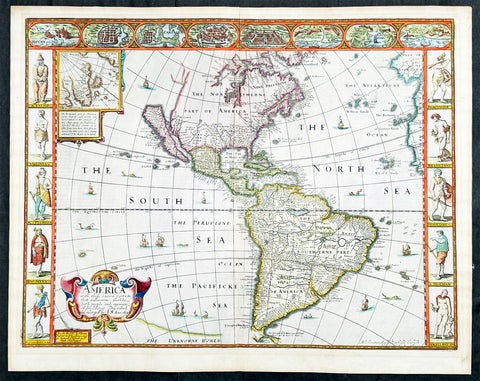
1626 (1676) John Speed Antique Map of America - Beautiful Condition
- Title : America with those known parts in that unknowne world both people and manner of buildings discribed and inlarged by I.S. Ano 1626.
- Date : 1626 (1676)
- Size: 21 1/2in x 17in (545mm x 430mm)
- Condition: (A+) Fine Condition
- Ref: 35654
Description:
This original hand coloured copper plate engraved antique map of America by John Speed was published in the 1676 Bassett & Chiswell edition of Speeds famous atlas Prospect of the Most Famous Parts of the World.
One of the best examples of this map I have seen. Beautiful original condition with original hand colour, clean heavy impression on sturdy clean paper with original margins, which is very rare.
This 1626 map of America is the fourth or 1676 state and is one of the most iconic maps of America, surrounded by decorative vignettes illustrating the indigenous peoples and cities of the Americas. This map is both beautiful and important. It features a number of first, including being the first atlas map to depict California as an island and to accurately depict the east coast of North America. Cartographically it follows on the earlier maps of the Dutchman Abraham Goos, the engraver, with updates to reflect the 1625 Briggs vision of an insular California
General Definitions:
Paper thickness and quality: - Heavy and stable
Paper color : - off white
Age of map color: - Original
Colors used: - Yellow, green, blue, pink
General color appearance: - Authentic
Paper size: - 21 1/2in x 17in (545mm x 430mm)
Plate size: - 20 1/4in x 15 1/2in (515mm x 395mm)
Margins: - Min 3/4in (20mm)
Imperfections:
Margins: - None
Plate area: - None
Verso: - Old archival hinge paper top of verso, not affecting the map.
Background:
This is the first atlas map to represent California as an island. The idea of an insular California first appeared as a work of fiction in Garci Rodriguez de Montalvo's c. 1510 romance Las Sergas de Esplandian, where he writes
.....Know, that on the right hand of the Indies there is an island called California very close to the side of the Terrestrial Paradise; and it is peopled by black women, without any man among them, for they live in the manner of Amazons.....
Baja California was subsequently discovered in 1533 by Fortun Ximenez, who had been sent to the area by Hernan Cortez. When Cortez himself traveled to Baja, he must have had Montalvo's novel in mind, for he immediately claimed the 'Island of California' for the Spanish King. By the late 16th and early 17th century ample evidence had been amassed, through explorations of the region by Francisco de Ulloa, Hernando de Alarcon and others, that California was in fact a peninsula. However, by this time other factors were in play. Francis Drake had sailed north and claimed 'New Albion' (identified here on the northwest coast of California Island) near modern day Washington or Vancouver for England. The Spanish thus needed to promote Cortez's claim on the 'Island of California' to preempt English claims on the western coast of North America. Henry Briggs, an English mathematician, began promoting the idea of an insular California in 1622, citing the journals of Friar Antonio de la Ascension, who accompanied the 1602-03 Sebastian Vizcaino expedition. The significant influence of the Spanish crown on European cartographers caused a major resurgence of the Insular California theory. Just before this map was made Eusebio Kino, a Jesuit missionary, traveled overland from Mexico to California, proving conclusively the peninsularity of California. Even so, it was ultimately a 1747 royal decree from King Ferdinand VII of Spain that finally forced cartographers to give up on the alluring idea.
Other elements of interest in North America are the complete absence of the Great Lakes - which in 1626 had yet to be conceived of by any European cartographers. The Straits of Anian appear tenuously in the extreme northwest, just above California. Just east of the 'o' in 'California', on the continental mainland, there is a curious ghosted in lake called the 'Lagueo de Oro.' We have found no references or explanation for this. None of the legendary kingdoms of gold, Quivara, Teguayo, Cibola, etc. are noted. The western portions of the Hudson Bay are unmapped - suggestive of their unexplored status. The addition of Long Island and Boston, in notably darker print, are important updates over the earliest editions.
South America offers much of interest including the mythical Lake Parimia, in Guiana. The legend of Parima is associated with the English adventurer Sir Walter Raleigh's search for El Dorado. Believing El Dorado to lie in the northern part of the Amazon, Raleigh sailed down the Orinoco River just before the onset of the rainy season. Reaching a remote tribal village, Raleigh noted canoes arriving bearing gold, silver, and other treasures. Asked where the gold came from, the natives replied, 'Manoa', the term for the tribe to which the river traders belonged. Manoa, the natives claimed could be reached following a long river voyage southward to a Great Lake, called Parima. Raleigh and his associates immediately associated Manoa and Lake Parima with the golden kingdom of El Dorado, though they never visited the city or lake. Subsequent maps, including this one, mapped el Dorado and Lake Parima in this location for several hundred years. Both Raleigh and the natives were describing an actual event known to occur annually in the region. Rains would annually swell the Amazon and Orinoco river systems creating a linkage in the Rupununu flood plain, which, during heavy rains, can resemble a massive lake. The Manoa were a large and populous trading nation active in pre-colonial days whose vast empire, based in the Amazon Basin, extended form the Andes to the Orinoco. Curiously, in addition to noting the city of Manoa on Lake Parima, D'Anville also correctly maps the center of the ancient Manoan civilization between the Amazon tributaries Rio Negro and Rio Yapura. Sadly the Manoa and many of the other populous South American indigenous nations noted by the earliest explores to the region vanished, brought low by European epidemics.
Another mythical lake, Eupana, appears further south connecting the Rio de la Plata and the Paraguay River to the R. Real, thus turning eastern Brazil into an island. This is a update over many earlier maps which connected Eupana directly to the Amazon. Far in the south Speed presents us ith another anomaly, the Straits of Le Maire, which separates Tierra de Fuego from another mysterious stretch of land labeled 'States Land.' The is in fact the modern island of Isla de los Estados, the southeastern most point in South America. Jacob le Maire and his pilot Willem Schouten passed to between this island and Tierra del Fuego on their 1615 voyage around Cape Horn and into the Pacific.
In the high Arctic, near Iceland and Greenland, the supposed islands of Frisland and Brasil are noted. Frisland is little more than a double mapping of Iceland. Brasil, also known as Hy-Brasil, is a phantom island north Atlantic just west of Ireland. In Irish myths it was said to be cloaked in mist, except for one day every seven years, when it became visible but still could not be reached. Little is known of this origins of this myth, but it appears on maps in various forms from about 1325. The last known appearance was in 1865 when it appeared on a nautical chart as 'Brasil Rock.' Some speculate that it may be an early reference to Porcupine Bank, a shoal in the Atlantic Ocean about 200 kilometres (120 mi) west of Ireland.
Speed's map of America is especially noteworthy for its surrounded vignettes. To either side of the map proper there are various vignettes illustrating the indigenous peoples of the America. These includes natives of Greenland, Virginia, Florida, Mexico, New England, Peru, Brazil, and Tierra del Feugo.n Along the top of the map there are eight city views: Havanna, Santo Domingo, Cartagena, Mexico City, Cuzco, the isle of Moca, Rio de Janeiro, and Olinda.
This map was engraved for John Speed by Abraham Goos. It is the fourth state of the map issued by Thomas Bassett of Fleet Street and Richard Chiswell of St. Paul's Churchyard. Bassett, Chiswell, and others continued to republish Speed's work well after his death. (Ref: Tooley, Koeman, Burden)
Please note all items auctioned are genuine, we do not sell reproductions. A Certificate of Authenticity (COA) can be issued on request.
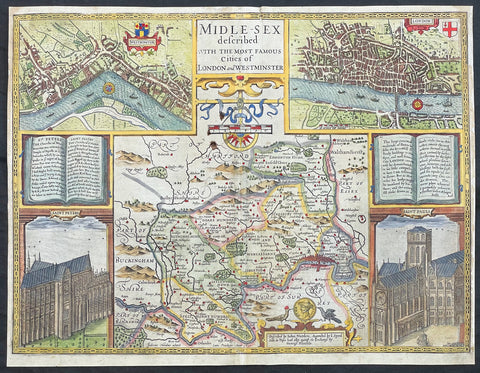
1627 John Speed Antique Map of Greater London, Middlesex with Birds Eye Views
- Title :Midle-sex Described with the most Famous Cities of London and Westminster
- Ref #: 17053
- Size: 20 1/2in x 16 1/4in (520mm x 410mm)
- Date : 17053
- Condition: (A) Very Good Condition
Description:
This original hand coloured antique map & views of London and the English county of Middlesex by John Speed was published in the 1627 edition of Speeds famous atlas The Theatre of the Empire of Great Britaine.
The map is embellished with the famous birds-eye views of London, Westminster and the churches of St Peters (Westminster Abbey) and old St Pauls before the great fire of London in 1666. English descriptive text of London on the verso.
General Definitions:
Paper thickness and quality: - Heavy and stable
Paper color : - off white
Age of map color: - Original
Colors used: - Yellow, green, blue, pink
General color appearance: - Authentic
Paper size: - 20 1/2in x 16 1/4in (520mm x 410mm)
Plate size: - 20 1/2in x 16 1/4in (520mm x 410mm)
Margins: - Min 1/2in (12mm)
Imperfections:
Margins: - L&R margins re-enforced by strips on verso
Plate area: - Light soiling
Verso: - Light toning
Background:
This county map of Middlesex, now greater London, illustrates the market towns of Enfield, Pancras, Osterley and Staines. The map is dominated by four large vignettes with the environs of London and the county situated in the central portion of the map. The actual cartography is based on the surveys performed by John Norden, the earlier English antiquary and map maker, who unsuccessfully attempted to publish an updated county atlas of the United Kingdom before Speed. Norden also lived most of his life in Middlesex, thus becoming an obvious source for the map.
The City of London is clearly shown on the lower right of the map with villages such as Hamsted, Pancras, Kensington and Paddington marked around the city. To the lower centre of the map is an acknowledgement to the original survey by Norden, augmented by Speed himself.
Although the cartography is of some note, it is the vignettes for which this map is justly famous. To the two bottom corners are the famous Churchs of St. Peter (Westminster Abbey) Westminster on the left and St. Pauls to the right. This is the medieval Cathedral of St. Pauls, just after it had lost its spire in 1561 and before the Great Fire of 1666, in which it was destroyed then rebuilt in its present form by Sir Christopher Wren. Above these two church vignettes are two text panels in the form of books, the one on the left describing the two churches and the other on the right with a description of London itself.
Finally, two large vignettes on the upper left and right corners depict the two cities of Westminster and London respectively. It is believed that Speed was not responsible for either of these images, more likely drawing from Norden, although there are no surviving evidence of this, to date yet to be found. There are also theories that these two views may have come from either a German sources or other lost birds-eye views of London by unknown persons.
Due to modern growth of London and border changes, the county of Middlesex no longer exists, but there is little doubt this is the most the best map of London and Middlesex published in the 17th century. English text on versoJohn Speed
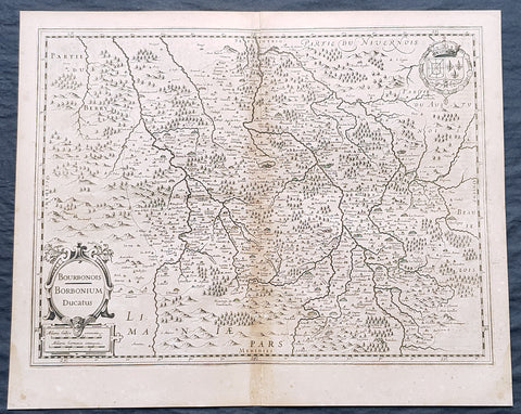
1628 Gerard Mercator & Henricus Hondius Antique Map Bourbonnais Region of France
- Title : Boubonoius; Borbonium Ducatus....
- Size: 21in x 17in (530mm x 430mm)
- Condition: (A) Very Good Condition
- Date : 1628
- Ref #: 26138
Description:
This original copper plate engraved antique map of the Bourbon or Bourbonnais Region of central France by Gerard Mercator was published by Henricus Hondius in the early 1628 French edition of Gerard Mercators Atlas.
These maps, published in the early editions of Mercators atlas, are the original maps drawn and engraved by Gerald Mercator in the mid to late 16th century, published by his son Rumold as an atlas, after his death, in 1595. After two editions the plates were purchased by Jodocus Hondius in 1604, and continued to be published until the end of the 1630s by Henricus Hondius, when some of the plates were re-engraved and updated with the help of Jan Jansson.
General Definitions:
Paper thickness and quality: - Heavy and stable
Paper color : - off white
Age of map color: -
Colors used: -
General color appearance: -
Paper size: - 21in x 17in (530mm x 430mm)
Plate size: - 18 1/2in x 14in (475mm x 350mm)
Margins: - Min 1/2in (12mm)
Imperfections:
Margins: - Light age toning
Plate area: - Light toning along centerfold
Verso: - Light age toning
Background:
Bourbonnais was a historic province in the centre of France that corresponded to the modern département of Allier, along with part of the département of Cher. Its capital was Moulins.
The title of the ruler of Bourbonnais between 913 and 1327, was Sire de Bourbon (or Seigneur de Bourbon). The first lord of Bourbonnais known by name was Adhémar (or Aymon I of Bourbon). Aymon\\\'s father was Aymar (894-953), sire of Souvigny, his only son with Ermengarde.Aymar lived during the reign of Charles the Simple who, in 913, gave him fiefs on the Allier River in which would become Bourbonnais. He acquired the castle of Bourbon (today Bourbon-l\\\'Archambault). Almost all early lords took the name d\\\'Archambaud, after the palace, but later the family became known as the \\\"House of Bourbon\\\".
The first House of Bourbon ended in 1196, with the death of Archambault VII, who had only one heir, Mathilde of Bourbon. She married Guy II of Dampierre, who added Montlucon to the possessions of the lords of Bourbon. The second house of Bourbon started in 1218, with Archambault VIII, son of Guy II and Mahaut, and brother of William II of Dampierre. He was followed by his son Archambaut IX, who died in Cyprus in 1249, during a crusade. The House of Burgundy then acquired Bourbonnais.
In 1272, Beatrice of Burgundy (1258-1310), Lady of Bourbon, married Robert de France (1256-1318), Count of Clermont, son of king Louis IX (Saint-Louis). Thus began the long-lasting House of Bourbon, which would provide the kings of France from Henry IV to Louis-Phillipe in 1848, when France abolished its monarchy.
The Bourbons had concluded an alliance with the royal power. They put their forces at the service of the king, thus benefitting from the geographic position of Bourbonnais, located between the royal fidemesne and the duchies of Aquitaine and Auvergne. This alliance, as well as the marriage of Béatrix de Bourgogne and Robert de France, aided the rise and prosperity of the province. In 1327, King Charles (le Bel) elevated Boubonnais to the status of a duchy. (Ref: Koeman; M&B; Tooley)
1628 Gerard Mercator & Henricus Hondius Antique Map Canton of Aargau Switzerland
- Title : Argow...Per Geradum Mercatorem Cum Privilego...
- Size: 21in x 17in (530mm x 430mm)
- Condition: (A) Very Good Condition
- Date : 1628
- Ref #: 26090
Description:
This original copper plate engraved antique map of the Canton of Aargau, Switzerland by Gerard Mercator was published by Henricus Hondius in the early 1628 French edition of Gerard Mercators Atlas.
These maps, published in the early editions of Mercators atlas, are the original maps drawn and engraved by Gerald Mercator in the mid to late 16th century, published by his son Rumold as an atlas, after his death, in 1595. After two editions the plates were purchased by Jodocus Hondius in 1604, and continued to be published until the end of the 1630s by Henricus Hondius, when some of the plates were re-engraved and updated with the help of Jan Jansson.
General Definitions:
Paper thickness and quality: - Heavy and stable
Paper color : - off white
Age of map color: -
Colors used: -
General color appearance: -
Paper size: - 21in x 17in (530mm x 430mm)
Plate size: - 18 1/2in x 14in (475mm x 350mm)
Margins: - Min 1/2in (12mm)
Imperfections:
Margins: - Light age toning
Plate area: - Light toning along centerfold
Verso: - Light age toning
Background:
The area of Aargau and the surrounding areas were controlled by the Helvetians, a member of the Celts, as far back as 200 BC, eventually being occupied by the Romans and then by the 6th century, the Franks. The Romans built a major settlement called Vindonissa, near the present location of Brugg.
The reconstructed Old High German name of Aargau is Argowe, first unambiguously attested (in the spelling Argue) in 795. The term described a territory only loosely equivalent to that of the modern canton, including the region between Aare and Reuss, including Pilatus and Napf, i.e. including parts of the modern cantons of Berne (Bernese Aargau, Emmental, parts of the Bernese Oberland), Solothurn, Basel-Landschaft, Lucerne, Obwalden and Nidwalden, but not the parts of the modern canton east of the Reuss (Baden District), which were part of Zürichgau.
Within the Frankish Empire (8th to 10th centuries), the area was a disputed border region between the duchies of Alamannia and Burgundy. A line of the von Wetterau (Conradines) intermittently held the countship of Aargau from 750 until about 1030, when they lost it (having in the meantime taken the name von Tegerfelden). This division became the ill-defined (and sparsely settled) outer border of the early Holy Roman Empire at its formation in the second half of the 10th century. Most of the region came under the control of the ducal house of Zähringen and the comital houses of Habsburg and Kyburg by about 1200.
In the second half of the 13th century, the territory became divided between the territories claimed by the imperial cities of Berne, Lucerne and Solothurn and the Swiss canton of Unterwalden. The remaining portion, largely corresponding to the modern canton of Aargau, remained under the control of the Habsburgs until the conquest of Aargau by the Old Swiss Confederacy in 1415. Habsburg Castle itself, the original seat of the House of Habsburg, was taken by Berne in April 1415. The Habsburgs had founded a number of monasteries (with some structures enduring, e.g., in Wettingen and Muri), the closing of which by the government in 1841 was a contributing factor to the outbreak of the Swiss civil war – the Sonderbund War – in 1847.
1628 Gerard Mercator & Henricus Hondius Antique Map Canton of Zurich Switzerland
- Title : Zurichgow...Per Geradum Mercatorem Cum Privilego...
- Size: 21in x 17in (530mm x 430mm)
- Condition: (A) Very Good Condition
- Date : 1628
- Ref #: 26093
Description:
This original copper plate engraved antique map of the Canton of Zurich, Switzerland by Gerard Mercator was published by Henricus Hondius in the early 1628 French edition of Gerard Mercators Atlas.
These maps, published in the early editions of Mercators atlas, are the original maps drawn and engraved by Gerald Mercator in the mid to late 16th century, published by his son Rumold as an atlas, after his death, in 1595. After two editions the plates were purchased by Jodocus Hondius in 1604, and continued to be published until the end of the 1630s by Henricus Hondius, when some of the plates were re-engraved and updated with the help of Jan Jansson.
General Definitions:
Paper thickness and quality: - Heavy and stable
Paper color : - off white
Age of map color: -
Colors used: -
General color appearance: -
Paper size: - 21in x 17in (530mm x 430mm)
Plate size: - 18 1/2in x 14in (475mm x 350mm)
Margins: - Min 1/2in (12mm)
Imperfections:
Margins: - Light age toning
Plate area: - Light toning along centerfold
Verso: - Light age toning
Background:
The territory of the canton of Zürich corresponds to the lands acquired by the city of Zürich after it became reichsfrei in 1218. Zürich pursued a policy of aggressive territorial expansion especially during the century following the revolution of the guilds in 1336. Zürich joined the Swiss Confederacy in 1351.
Zürich claimed and lost the Toggenburg in the Old Zürich War of the 1440s. The northern parts up to the river Rhine came to the canton after the city of Zürich purchased Winterthur from the Habsburgs in 1468. In 1651, Zürich purchased Rafzerfeld from the counts of Sulz. At this point, almost all of the territory of the modern canton (as well as some territories beyond its modern borders) was owned by Zürich; exceptions include Wülflingen (acquired 1760), Buch (acquired 1761), Dietikon, which was a condominium, and Rheinau (owned by Rheinau Abbey).
In the 18th century, the inner bailiwicks (Innere Vogteien) were under direct administration of city officials, while the outer bailiwicks (Äussere Vogteien) were ruled by the reeves of Kyburg, Grüningen, Greifensee, Eglisau, Regensberg, Andelfingen, Wädenswil, and Knonau. The city of Winterthur was nominally subject to Zürich but retained far-reaching autonomy.
Zürichgau, the name of the medieval pagus, was in use for the territories of the city of Zürich during the 15th and 16th century; the term canton (Kanton) gradually entered use in the 16th century, but Zürichgau remained widely used well into the 19th century (becoming obsolescent after the formation of the modern canton in 1831).
Under the short-lived Helvetic Republic (1798–1803), the canton of Zürich became a purely administrative division. In 1803, some former possessions of Zürich to the west gained independence as part of the Canton of Aargau. In 1804 the Kantonspolizei Zürich was established as Landjäger-Corps des Kantons Zürich.
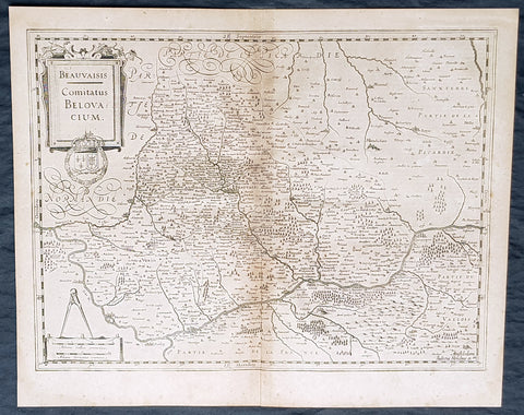
1628 Gerard Mercator & Henricus Hondius Antique Map of Beauvais Region, France
- Title : Beauvaisis Comitatus Belovacium
- Size: 21in x 17in (530mm x 430mm)
- Condition: (A) Very Good Condition
- Date : 1628
- Ref #: 26136
Description:
This original copper plate engraved antique map of the Beauvais region of Northern France - centering on the city of Beauvais & the Oise River running through the cities of Noyon, Compiègne, Creil by Gerard Mercator was published by Henricus Hondius in the early 1628 French edition of Gerard Mercators Atlas.
These maps, published in the early editions of Mercators atlas, are the original maps drawn and engraved by Gerald Mercator in the mid to late 16th century, published by his son Rumold as an atlas, after his death, in 1595. After two editions the plates were purchased by Jodocus Hondius in 1604, and continued to be published until the end of the 1630s by Henricus Hondius, when some of the plates were re-engraved and updated with the help of Jan Jansson.
General Definitions:
Paper thickness and quality: - Heavy and stable
Paper color : - off white
Age of map color: -
Colors used: -
General color appearance: -
Paper size: - 21in x 17in (530mm x 430mm)
Plate size: - 18 1/2in x 14in (475mm x 350mm)
Margins: - Min 1/2in (12mm)
Imperfections:
Margins: - Light age toning
Plate area: - Light toning along centerfold
Verso: - Light age toning
Background:
Beauvais is a city and commune in northern France. It serves as the capital of the Oise département, in the Hauts-de-France region. Beauvais is located approximately 75 kilometres from Paris.
Beauvais was known to the Romans by the Gallo-Roman name of Caesaromagus (magos is Common Celtic for field). The post-Renaissance Latin rendering is Bellovacum from the Belgic tribe the Bellovaci, whose capital it was. In the ninth century it became a countship, which about 1013 passed to the bishops of Beauvais, who became peers of France from the twelfth century. At the coronations of kings the Bishop of Beauvais wore the royal mantle and went, with the Bishop of Langres, to raise the king from his throne to present him to the people.
De Bello Gallico II 13 reports that as Julius Caesar was approaching a fortified town called Bratuspantium in the land of the Bellovaci, its inhabitants surrendered to him when he was about 5 Roman miles away. Its name is Gaulish for place where judgements are made, from *bratu-spantion. Some say that Bratuspantium is Beauvais. Others theorize that it is Vendeuil-Caply or Bailleul sur Thérain.
From 1004 to 1037, the Count of Beauvais was Odo II, Count of Blois.
In a charter dated 1056/1060, Eudo of Brittany granted land in pago Belvacensi (Beauvais, Picardy) to the Abbey of Angers Saint-Aubin
In 1346 the town had to defend itself against the English, who again besieged it in 1433. The siege which it endured in 1472 at the hands of the Duke of Burgundy, was rendered famous by the heroism of the towns women, under the leadership of Jeanne Hachette, whose memory is still celebrated by a procession on 27 June (the feast of Sainte Angadrême), during which women take precedence over men.
An interesting hoard of coins from the High Middle Ages became known as the Beauvais Hoard, because some of the British and European coins found with the lot were from the French abbey located in Beauvais. The hoard, which contained a variety of rare and extremely rare Anglo-Norman pennies, English and foreign coins, was reputed to have been found in or near Paris.
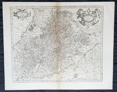
1628 Gerard Mercator & Henricus Hondius Antique Map of Duchy Wurttemberg Germany
- Title : Wirtenberg Ducatus...Per Geradum Mercatorem Cum Privilego
- Size: 21in x 17in (530mm x 430mm)
- Condition: (A+) Fine Condition
- Date : 1628
- Ref #: 26116
Description:
This original copper plate engraved antique map of Wurttemberg in todays Baden-Württemberg state in southern Germany, by Gerard Mercator was published by Henricus Hondius in the early 1628 French edition of Gerard Mercators Atlas.
These maps, published in the early editions of Mercators atlas, are the original maps drawn and engraved by Gerald Mercator in the mid to late 16th century, published by his son Rumold as an atlas, after his death, in 1595. After two editions the plates were purchased by Jodocus Hondius in 1604 and continued to be published until the mid 1630\'s when the plates were re-engraved and updated by Jan Jansson and Henricus Hondius.
General Definitions:
Paper thickness and quality: - Heavy and stable
Paper color : - off white
Age of map color: -
Colors used: -
General color appearance: -
Paper size: - 21in x 17in (530mm x 430mm)
Plate size: - 18 1/2in x 14in (475mm x 350mm)
Margins: - Min 1/2in (12mm)
Imperfections:
Margins: - Light age toning
Plate area: - Light toning along centerfold
Verso: - Light age toning
Background:
Württemberg is a historical German territory roughly corresponding to the cultural and linguistic region of Swabia. Together with Baden and Hohenzollern, two other historical territories, it now forms the Federal State of Baden-Württemberg. Württemberg was formerly also spelled Würtemberg and Wirtemberg.
The Duchy of Württemberg was a duchy located in the south-western part of the Holy Roman Empire. It was a member of the Holy Roman Empire from 1495 to 1806. The dukedoms long survival for nearly four centuries was mainly due to its size, being larger than its immediate neighbors. During the Protestant Reformation, Württemberg faced great pressure from the Holy Roman Empire to remain a member. Württemberg resisted repeated French invasions in the 17th and 18th centuries. Württemberg was directly in the path of French and Austrian armies who were engaged in the long rivalry between the House of Bourbon and the House of Habsburg. In 1803, Napoleon raised the duchy to be the Electorate of Württemberg of the Holy Roman Empire. On 1 January 1806, the last Elector assumed the title of King of Württemberg. Later this year, on 6 August 1806, the last Emperor, Francis II, abolished (de facto) the Holy Roman Empire.
1628 Gerard Mercator & Henricus Hondius Antique Map of Westphalia, Germany
- Title : Tabula Seconde Westphalia...Per Geradum Mercatorem Cum Privilego...1627
- Size: 21in x 17in (530mm x 430mm)
- Condition: (A) Very Good Condition
- Date : 1628
- Ref #: 26109
Description:
This original copper plate engraved antique map of the Westphalia region of North Rhine-Westphalia, Germany, by Gerard Mercator was published by Henricus Hondius in the early 1628 French edition of Gerard Mercators Atlas.
These maps, published in the early editions of Mercators atlas, are the original maps drawn and engraved by Gerald Mercator in the mid to late 16th century, published by his son Rumold as an atlas, after his death, in 1595. After two editions the plates were purchased by Jodocus Hondius in 1604 and continued to be published until the mid 1630s by Henricus, when some of the plates were re-engraved and updated by Jan Jansson and Henricus Hondius.
General Definitions:
Paper thickness and quality: - Heavy and stable
Paper color : - off white
Age of map color: -
Colors used: -
General color appearance: -
Paper size: - 21in x 17in (530mm x 430mm)
Plate size: - 18 1/2in x 14in (475mm x 350mm)
Margins: - Min 1/2in (12mm)
Imperfections:
Margins: - Light age toning
Plate area: - Light toning along centerfold
Verso: - Light age toning
Background:
While the Northern Rhineland, Westphalia and Lippe are different historic territories of todays North Rhine-Westphalia, the old border between the former Rhine Province and the Province of Westphalia is also a language border. While in Westphalia and Lippe, people tend to speak West Low German dialects and especially the Westphalian variant of the Low German language, Central German and Low Franconian dialects are being spoken in the Northern Rhineland.
Westphalia is known for the 1648 Peace of Westphalia which ended the Thirty Years War, as the two treaties were signed in Münster and Osnabrück.
It is one of the regions that were part of all incarnations of the German state since the Early Middle Ages: the Holy Roman Empire, the Confederation of the Rhine, the German Confederation, the North German Confederation, the German Empire, the Weimar Republic and National Socialist Germany. After World War II it was a part of the British occupation zone which merged with the American zone to become the Bizone in 1947 and again merged with the French zone to become the Trizone in 1948. The current Federal Republic of Germany was founded on these territories making Westphalia a part of West Germany. It is a part of united Germany since 1990.
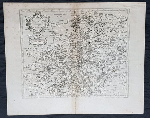
1628 Gerard Mercator & Henricus Hondius Antique Map State of Hesse, Germany
- Title : Hassia landtgrauiatus...Per Geradum Mercatorem Cum Privilego
- Size: 21in x 17in (530mm x 430mm)
- Condition: (A) Very Good Condition
- Date : 1628
- Ref #: 26107
Description:
This original copper plate engraved antique map of the State of Hesse or Hessia, in central Germany, by Gerard Mercator was published by Henricus Hondius in the early 1628 French edition of Gerard Mercators Atlas.
These maps, published in the early editions of Mercators atlas, are the original maps drawn and engraved by Gerald Mercator in the mid to late 16th century, published by his son Rumold as an atlas, after his death, in 1595. After two editions the plates were purchased by Jodocus Hondius in 1604 and continued to be published until the mid 1630s by Henricus, when some of the plates were re-engraved and updated by Jan Jansson and Henricus Hondius.
General Definitions:
Paper thickness and quality: - Heavy and stable
Paper color : - off white
Age of map color: -
Colors used: -
General color appearance: -
Paper size: - 21in x 17in (530mm x 430mm)
Plate size: - 18 1/2in x 14in (475mm x 350mm)
Margins: - Min 1/2in (12mm)
Imperfections:
Margins: - Light age toning
Plate area: - Light toning along centerfold
Verso: - Light age toning
Background:
Hesse officially the State of Hesse, is a federal state (Land) of the Federal Republic of Germany, with just over six million inhabitants. The state capital is Wiesbaden; the largest city is Frankfurt am Main.
In the 12th century, Hessengau was passed to Thuringia. In the War of the Thuringian Succession (1247–1264), Hesse gained independence and became a Landgraviate within the Holy Roman Empire. It shortly rose to primary importance under Landgrave Philip the Magnanimous, who was one of the leaders of German Protestantism. After Philips death in 1567, the territory was divided among his four sons from his first marriage (Philip was a bigamist) into four lines: Hesse-Kassel (or Hesse-Cassel), Hesse-Darmstadt, Hesse-Rheinfels, and the also previously existing Hesse-Marburg. As the latter two lines died out quite soon (1583 and 1605, respectively), Hesse-Kassel and Hesse-Darmstadt were the two core states within the Hessian lands. Several collateral lines split off during the centuries, such as in 1622, when Hesse-Homburg split off from Hesse-Darmstadt. In the late 16th century, Kassel adopted Calvinism, while Darmstadt remained Lutheran and subsequently the two lines often found themselves on different sides of a conflict, most notably in the disputes over Hesse-Marburg and in the Thirty Years War, when Darmstadt fought on the side of the Emperor, while Kassel sided with Sweden and France.
The Landgrave Frederick II (1720–1785) ruled as a benevolent despot, from 1760 to 1785. He combined Enlightenment ideas with Christian values, cameralist plans for central control of the economy, and a militaristic approach toward diplomacy.[16] He funded the depleted treasury of the poor nation by loaning 19,000 soldiers in complete military formations to Great Britain to fight in North America during the American Revolutionary War, 1776–1783. These soldiers, commonly known as Hessians, fought under the British flag. The British used the Hessians in several conflicts, including in the Irish Rebellion of 1798. For further revenue, the soldiers were loaned to other places as well. Most were conscripted, with their pay going to the Landgrave.
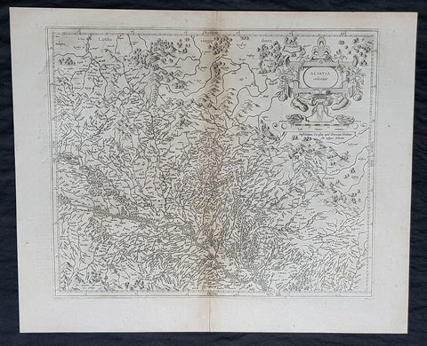
1628 Gerard Mercator & Henricus Hondius Antique Map the Alsace Region of France
- Title : Alsatia inferior..Per Gerardam Mercatorem Cum privilegio
- Size: 21in x 17in (530mm x 430mm)
- Condition: (A) Very Good Condition
- Date : 1628
- Ref #: 26113
Description:
This original copper plate engraved antique map of the French region of Alsace by Gerard Mercator was published by Henricus Hondius in the early 1628 French edition of Gerard Mercators Atlas.
These maps, published in the early editions of Mercators atlas, are the original maps drawn and engraved by Gerald Mercator in the mid to late 16th century, published by his son Rumold as an atlas, after his death, in 1595. After two editions the plates were purchased by Jodocus Hondius in 1604, and continued to be published until the end of the 1630s by Henricus Hondius, when some of the plates were re-engraved and updated with the help of Jan Jansson.
General Definitions:
Paper thickness and quality: - Heavy and stable
Paper color : - off white
Age of map color: -
Colors used: -
General color appearance: -
Paper size: - 21in x 17in (530mm x 430mm)
Plate size: - 18 1/2in x 14in (475mm x 350mm)
Margins: - Min 1/2in (12mm)
Imperfections:
Margins: - Light age toning
Plate area: - Light toning along centerfold
Verso: - Light age toning
Background:
Alsace is a cultural and historical region in eastern France, on the west bank of the upper Rhine next to Germany and Switzerland.
As in much of Europe, the prosperity of Alsace came to an end in the 14th century by a series of harsh winters, bad harvests, and the Black Death. These hardships were blamed on Jews, leading to the pogroms of 1336 and 1339. In 1349, Jews of Alsace were accused of poisoning the wells with plague, leading to the massacre of thousands of Jews during the Strasbourg pogrom. Jews were subsequently forbidden to settle in the town. An additional natural disaster was the Rhine rift earthquake of 1356, one of Europes worst which made ruins of Basel. Prosperity returned to Alsace under Habsburg administration during the Renaissance.
Holy Roman Empire central power had begun to decline following years of imperial adventures in Italian lands, often ceding hegemony in Western Europe to France, which had long since centralized power. France began an aggressive policy of expanding eastward, first to the rivers Rhône and Meuse, and when those borders were reached, aiming for the Rhine. In 1299, the French proposed a marriage alliance between Philip IV of Frances sister Blanche and Albert I of Germanys son Rudolf, with Alsace to be the dowry; however, the deal never came off. In 1307, the town of Belfort was first chartered by the Counts of Montbéliard. During the next century, France was to be militarily shattered by the Hundred Years War, which prevented for a time any further tendencies in this direction. After the conclusion of the war, France was again free to pursue its desire to reach the Rhine and in 1444 a French army appeared in Lorraine and Alsace. It took up winter quarters, demanded the submission of Metz and Strasbourg and launched an attack on Basel.
In 1469, following the Treaty of St. Omer [fr], Upper Alsace was sold by Archduke Sigismund of Austria to Charles the Bold, Duke of Burgundy. Although Charles was the nominal landlord, taxes were paid to Frederick III, Holy Roman Emperor. The latter was able to use this tax and a dynastic marriage to his advantage to gain back full control of Upper Alsace (apart from the free towns, but including Belfort) in 1477 when it became part of the demesne of the Habsburg family, who were also rulers of the empire. The town of Mulhouse joined the Swiss Confederation in 1515, where it was to remain until 1798.
By the time of the Protestant Reformation in the 16th century, Strasbourg was a prosperous community, and its inhabitants accepted Protestantism in 1523. Martin Bucer was a prominent Protestant reformer in the region. His efforts were countered by the Roman Catholic Habsburgs who tried to eradicate heresy in Upper Alsace. As a result, Alsace was transformed into a mosaic of Catholic and Protestant territories. On the other hand, Mömpelgard (Montbéliard) to the southwest of Alsace, belonging to the Counts of Württemberg since 1397, remained a Protestant enclave in France until 1793.
This situation prevailed until 1639, when most of Alsace was conquered by France to keep it out of the hands of the Spanish Habsburgs, who by secret treaty in 1617 had gained a clear road to their valuable and rebellious possessions in the Spanish Netherlands, the Spanish Road. Beset by enemies and seeking to gain a free hand in Hungary, the Habsburgs sold their Sundgau territory (mostly in Upper Alsace) to France in 1646, which had occupied it, for the sum of 1.2 million Thalers. When hostilities were concluded in 1648 with the Treaty of Westphalia, most of Alsace was recognized as part of France, although some towns remained independent. The treaty stipulations regarding Alsace were complex. Although the French king gained sovereignty, existing rights and customs of the inhabitants were largely preserved. France continued to maintain its customs border along the Vosges mountains where it had been, leaving Alsace more economically oriented to neighbouring German-speaking lands. The German language remained in use in local administration, in schools, and at the (Lutheran) University of Strasbourg, which continued to draw students from other German-speaking lands. The 1685 Edict of Fontainebleau, by which the French king ordered the suppression of French Protestantism, was not applied in Alsace. France did endeavour to promote Catholicism. Strasbourg Cathedral, for example, which had been Lutheran from 1524 to 1681, was returned to the Catholic Church. However, compared to the rest of France, Alsace enjoyed a climate of religious tolerance.
France consolidated its hold with the 1679 Treaties of Nijmegen, which brought most remaining towns under its control. France seized Strasbourg in 1681 in an unprovoked action. These territorial changes were recognised in the 1697 Treaty of Ryswick that ended the War of the Grand Alliance.
The year 1789 brought the French Revolution and with it the first division of Alsace into the départements of Haut- and Bas-Rhin. Alsatians played an active role in the French Revolution. On 21 July 1789, after receiving news of the Storming of the Bastille in Paris, a crowd of people stormed the Strasbourg city hall, forcing the city administrators to flee and putting symbolically an end to the feudal system in Alsace. In 1792, Rouget de Lisle composed in Strasbourg the Revolutionary marching song La Marseillaise (as Marching song for the Army of the Rhine), which later became the anthem of France. La Marseillaise was played for the first time in April of that year in front of the mayor of Strasbourg Philippe-Frédéric de Dietrich. Some of the most famous generals of the French Revolution also came from Alsace, notably Kellermann, the victor of Valmy, Kléber, who led the armies of the French Republic in Vendée and Westermann, who also fought in the Vendée.
At the same time, some Alsatians were in opposition to the Jacobins and sympathetic to the restoration of the monarchy pursued by the invading forces of Austria and Prussia who sought to crush the nascent revolutionary republic. Many of the residents of the Sundgau made pilgrimages to places like Mariastein Abbey, near Basel, in Switzerland, for baptisms and weddings. When the French Revolutionary Army of the Rhine was victorious, tens of thousands fled east before it. When they were later permitted to return (in some cases not until 1799), it was often to find that their lands and homes had been confiscated. These conditions led to emigration by hundreds of families to newly vacant lands in the Russian Empire in 1803–4 and again in 1808. A poignant retelling of this event based on what Goethe had personally witnessed can be found in his long poem Hermann and Dorothea.
In response to the hundred day restoration of Napoleon I of France in 1815, Alsace along with other frontier provinces of France was occupied by foreign forces from 1815 to 1818, including over 280,000 soldiers and 90,000 horses in Bas-Rhin alone. This had grave effects on trade and the economy of the region since former overland trade routes were switched to newly opened Mediterranean and Atlantic seaports.
The population grew rapidly, from 800,000 in 1814 to 914,000 in 1830 and 1,067,000 in 1846. The combination of economic and demographic factors led to hunger, housing shortages and a lack of work for young people. Thus, it is not surprising that people left Alsace, not only for Paris – where the Alsatian community grew in numbers, with famous members such as Baron Haussmann – but also for more distant places like Russia and the Austrian Empire, to take advantage of the new opportunities offered there: Austria had conquered lands in Eastern Europe from the Ottoman Empire and offered generous terms to colonists as a way of consolidating its hold on the new territories. Many Alsatians also began to sail to the United States, settling in many areas from 1820 to 1850. In 1843 and 1844, sailing ships bringing immigrant families from Alsace arrived at the port of New York. Some settled in Texas and Illinois, many to farm or to seek success in commercial ventures: for example, the sailing ships Sully (in May 1843) and Iowa (in June 1844) brought families who set up homes in northern Illinois and northern Indiana. Some Alsatian immigrants were noted for their roles in 19th-century American economic development. Others ventured to Canada to settle in southwestern Ontario, notably Waterloo County.
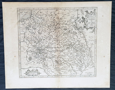
1628 Gerard Mercator & Henricus Hondius Antique Map the Picardy Region of France
- Title : France Picardie Champagne cum regionibus adiacentibus
- Size: 21in x 17in (530mm x 430mm)
- Condition: (A) Very Good Condition
- Date : 1628
- Ref #: 26131
Description:
This original copper plate engraved antique map of the French region of Picardy or Picardie by Gerard Mercator was published by Henricus Hondius in the early 1628 French edition of Gerard Mercators Atlas.
These maps, published in the early editions of Mercators atlas, are the original maps drawn and engraved by Gerald Mercator in the mid to late 16th century, published by his son Rumold as an atlas, after his death, in 1595. After two editions the plates were purchased by Jodocus Hondius in 1604, and continued to be published until the end of the 1630s by Henricus Hondius, when some of the plates were re-engraved and updated with the help of Jan Jansson.
General Definitions:
Paper thickness and quality: - Heavy and stable
Paper color : - off white
Age of map color: -
Colors used: -
General color appearance: -
Paper size: - 21in x 17in (530mm x 430mm)
Plate size: - 18 1/2in x 14in (475mm x 350mm)
Margins: - Min 1/2in (12mm)
Imperfections:
Margins: - Light age toning
Plate area: - Light toning along centerfold
Verso: - Light age toning
Background:
Picardy is a historical territory and a former administrative region of Northern France and now part of the new region Nord-Pas-de-Calais-Picardie.
From the 5th century the area was part of the Frankish Empire, and in the feudal period it encompassed the six countships of Boulogne, Montreuil, Ponthieu, Amiénois,Vermandois, and Laonnois. According to the 843 Treaty of Verdun the region became part of West Francia, the later Kingdom of France.
The name Picardy (which may have referred to a Frankish tribe of picards or pike-bearers) was not used until the 12th or 13th century. During this time, the name applied to all lands where the Picard language was spoken, which included all the territories from Paris to the Netherlands. In the Latin Quarter of Paris, people identified a Picard Nation (Nation Picarde) of students at Sorbonne University, most of whom actually came from Flanders. During the Hundred Years\\\' War, Picardy was the centre of the Jacquerie peasant revolt in 1358.
From 1419 onwards, the Picardy counties (Boulogne, Ponthieu, Amiens, Vermandois) were gradually acquired by the Burgundian duke Philip the Good, confirmed by King Charles VII of France at the 1435 Congress of Arras. In 1477, King Louis XI of France led an army and occupied key towns in Picardy. By the end of 1477, Louis would control all of Picardy and most of Artois.
In the 16th century, the government (military region) of Picardy was created. This became a new administrative region of France, separate from what was historically defined as Picardy. The new Picardy included the Somme département, the northern half of the Aisne département, and a small fringe in the north of the Oise département.
In 1557, Picardy was invaded by Hapbsburg forces under the command of Emmanuel Philibert, Duke of Savoy. After a seventeen-day siege, St. Quentin would be ransacked while Noyon would be burned by the Habsburg army.
In the 17th century, an infectious disease similar to English sweat originated from the region and spread across France. It was called Suette des picards or Picardy sweat.
Sugar beet was introduced by Napoleon I during the Napoleonic Wars in the 19th century, in order to counter the United Kingdom, which had seized the sugar islands possessed by France in the Caribbean. The sugar industry has continued to play a prominent role in the economy of the region.
One of the most significant historical events to occur in Picardy was the series of battles fought along the Somme during World War I. From September 1914 to August 1918, four major battles, including the Battle of the Somme, were fought by British, French, and German forces in the fields of Northern Picardy. (Ref: Koeman; M&B; Tooley)
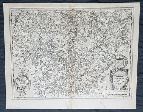
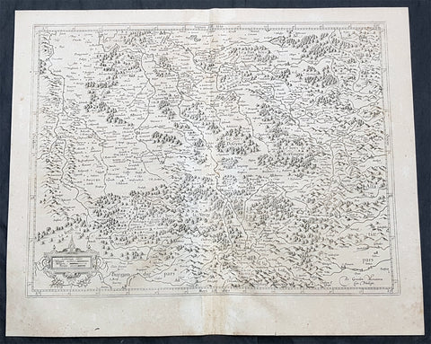
1628 Gerard Mercator & Henricus Hondius Antique Map, Champagne Region of France
- Title : Champagne...Comitatus Campania
- Size: 21in x 17in (530mm x 430mm)
- Condition: (A) Very Good Condition
- Date : 1628
- Ref #: 26134
Description:
This original copper plate engraved antique map of the French region of Champagne by Gerard Mercator was published by Henricus Hondius in the early 1628 French edition of Gerard Mercators Atlas.
These maps, published in the early editions of Mercators atlas, are the original maps drawn and engraved by Gerald Mercator in the mid to late 16th century, published by his son Rumold as an atlas, after his death, in 1595. After two editions the plates were purchased by Jodocus Hondius in 1604, and continued to be published until the end of the 1630s by Henricus Hondius, when some of the plates were re-engraved and updated with the help of Jan Jansson.
General Definitions:
Paper thickness and quality: - Heavy and stable
Paper color : - off white
Age of map color: -
Colors used: -
General color appearance: -
Paper size: - 21in x 17in (530mm x 430mm)
Plate size: - 18 1/2in x 14in (475mm x 350mm)
Margins: - Min 1/2in (12mm)
Imperfections:
Margins: - Light age toning
Plate area: - Light toning along centerfold
Verso: - Light age toning
1628 Gerard Mercator & Henricus Hondius Antique Map, Champagne Region of France
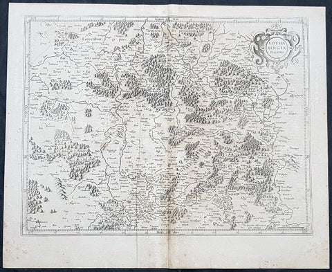
1628 Gerard Mercator Antique Map Lotharingia Region - Netherlands Germany France
- Title : Lotharingia Ducatus...Per Geradum Mercatorem Cum Privilegio
- Size: 21in x 17in (530mm x 430mm)
- Condition: (A) Very Good Condition
- Date : 1628
- Ref #: 26141
Description:
This original copper plate engraved antique map of the historical region of Lotharingia region of present-day Netherlands, Belgium, Luxembourg, North Rhine-Westphalia (Germany), Rhineland-Palatinate (Germany), Saarland (Germany), and Lorraine (France) by Gerard Mercator was published by Henricus Hondius in the early 1628 French edition of Gerard Mercators Atlas.
These maps, published in the early editions of Mercators atlas, are the original maps drawn and engraved by Gerald Mercator in the mid to late 16th century, published by his son Rumold as an atlas, after his death, in 1595. After two editions the plates were purchased by Jodocus Hondius in 1604 and continued to be published until the mid 1630\\\'s when the plates were re-engraved and updated by Jan Jansson and Henricus Hondius.
General Definitions:
Paper thickness and quality: - Heavy and stable
Paper color : - off white
Age of map color: -
Colors used: -
General color appearance: -
Paper size: - 21in x 17in (530mm x 430mm)
Plate size: - 20in x 15in (510mm x 380mm)
Margins: - Min 1/2in (12mm)
Imperfections:
Margins: - Age toning
Plate area: - Age toning
Verso: - Age toning
Lotharingia was a medieval successor kingdom of the Carolingian Empire, comprising the present-day Netherlands, Belgium, Luxembourg, North Rhine-Westphalia (Germany), Rhineland-Palatinate (Germany), Saarland (Germany), and Lorraine (France). It was named after King Lothair II who received this territory after the kingdom of Middle Francia of his father Lothair I was divided among his sons in 855.
Lotharingia was born out of the tripartite division in 855 of the kingdom of Middle Francia, which itself was formed after the threefold division of the Carolingian Empire by the Treaty of Verdun of 843. Conflict between East and West Francia over Lotharingia was based on the fact that these were the old Frankish homelands of Austrasia, so possession of them was of great prestige.
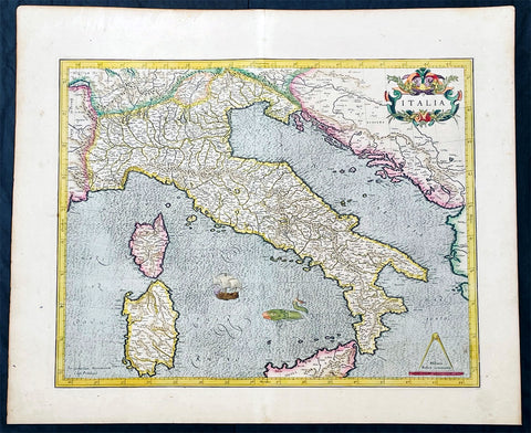
1628 Gerard Mercator Antique Map of Italy, Italia - Beautiful 1st Ed.
Antique Map
- Title : Italia
- Ref #: 35627
- Condition: (A+) Fine Condition
- Size: 22 1/2in x 18 1/2in (615mm x 470mm)
- Date: 1628
- Price: $1050.00US
Description:
This original beautifully hand coloured copper plate engraved antique map of Italy by Gerard Mercator, his first map of Italy for Atlas, was published in the 1628 Latin edition of Mercators Atlas Atlas Sive Cosmographicae Meditationes De Fabrica Mundi
This is a beautiful map with original hand colouring, heavy age toned paper with a deep impression. Beautiful map.
General Definitions:
Paper thickness and quality: - Heavy and stable
Paper color : - Off white
Age of map color: - Original
Colors used: - Yellow, green, blue, pink
General color appearance: - Authentic
Paper size: - 22 1/2in x 18 1/2in (615mm x 470mm)
Plate size: - 18 1/2in x 15in (470mm x 385mm)
Margins: - Min 1/2in (12mm)
Imperfections:
Margins: - None
Plate area: - Crease along centerfold
Verso: - None
Background:
Since classical times the countries bordering the enclosed waters of the Mediterranean had been well versed in the use of maps and sea charts and in Italy, more than anywhere else, the traditional knowledge was kept alive during the many hundreds of years following the collapse of the Roman Empire. By the thirteenth and fourteenth centuries the seamen of Venice, Genoa and Amalfi traded to far countries, from the Black Sea ports and the coasts of Palestine and Egypt in the East to Flanders and the southern coasts of England and Ireland in the West, their voyages guided by portulan charts and the use of the newly invented compass. For a time Italian supremacy in cartography passed to Aragon and the Catalan map makers based on Majorca, but by the year 1400 the power and wealth of the city states of Venice, Genoa, Florence and Milan surpassed any in Europe. Florence, especially, under the rule of the Medici family, became not only a great trading and financial centre but also the focal point of the rediscovery of the arts and learning of the ancient world. In this milieu a number of manuscript world maps were produced, of which one by Fra Mauro (c. 1459) is the most notable, but the event of the greatest importance in the history of cartography occurred in the year 1400 when a Florentine, Palla Strozzi, brought from Constantinople a Greek manuscript copy of Claudius Ptolemy's Geographia, which, 1,250 years after its compilation, came as a revelation to scholars in Western Europe. In the following fifty years or so manuscript copies, translated into Latin and other languages, became available in limited numbers but the invention of movable-type printing transformed the scene: the first copy without maps being printed in 1475 followed by many with copper-engraved maps, at Bologna in 1477, Rome 1478, 1490, 1507 and 1508, and Florence 1482.
About the year 1485 the first book of sea charts, compiled by Bartolommeo dalli Sonetti, was printed in Venice and in the first part of the sixteenth century a number of world maps were published, among them one compiled in 1506 by Giovanni Contarini, engraved by Francesco Rosselli, which was the first printed map to show the discoveries in the New World. In the following years there were many attractive and unusual maps of Islands (Isolano) by Bordone, Camocio and Porcacchi, but more important was the work of Giacomo (Jacopo) Gastaldi, a native of Piedmont who started life as an engineer in the service of the Venetian Republic before turning to cartography as a profession. His maps, produced in great variety and quantity, were beautifully drawn copperplate engravings and his style and techniques were widely copied by his contemporaries. From about 1550 to 1580 many of Gastaldi's maps appeared in the collections of maps known as Lafreri 'atlases', a term applied to groups of maps by different cartographers brought together in one binding. As the contents of such collections varied considerably they were no doubt assembled at the special request of wealthy patrons and are now very rare indeed.
About this time, for a variety of historical and commercial reasons, Italy's position as the leading trading and financial nation rapidly declined and with it her superiority in cartography was lost to the vigorous new states in the Low Countries. That is not to say, of course, that Italian skills as map makers were lost entirely for it was not until 1620 that the first printed maps of Italy by an Italian, Giovanni Magini, appeared, and much later in the century there were fine maps by Giacomo de Rossi and Vincenzo Coronelli, the latter leading a revival of interest in cartography at the end of the century. Coronelli was also famous for the construction of magnificent large-size globes and for the foundation in Venice in 1680 of the first geographical society.
In the eighteenth century the best-known names are Antonio Zatta, Rizzi-Zannoni and Giovanni Cassini.
We ought to mention the work of Baptista Boazio who drew a series of maps in A Summarie and True Discourse of Sir Francis Drake's West Indian Voyage, published in 1588-89, and who is especially noted for a very fine map of Ireland printed in 1599 which was incorporated in the later editions of the Ortelius atlases. It is perhaps appropriate also to refer to two English map makers who spent many years in exile in Italy: the first, George Lily, famous for the splendid map of the British Isles issued in Rome in 1546, and the second, Robert Dudley, who exactly one hundred years later was responsible for the finest sea atlas of the day, Dell' Arcano del Mare, published in Florence. Both of these are described in greater detail elsewhere in this handbook. (Ref: Tooley, Koeman)
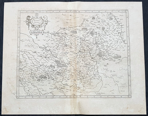
1628 Gerard Mercator Antique Map of the Berry Province of central France
- Title : Berry Ducatus...Per Geradum Mercatorem Cum Privilegio
- Size: 21in x 17in (530mm x 430mm)
- Condition: (A) Very Good Condition
- Date : 1628
- Ref #: 26137
Description:
This original copper plate engraved antique map of the Berry Province of central France by Gerard Mercator was published by Henricus Hondius in the early 1628 French edition of Gerard Mercators Atlas.
These maps, published in the early editions of Mercators atlas, are the original maps drawn and engraved by Gerald Mercator in the mid to late 16th century, published by his son Rumold as an atlas, after his death, in 1595. After two editions the plates were purchased by Jodocus Hondius in 1604 and continued to be published until the mid 1630\\\'s when the plates were re-engraved and updated by Jan Jansson and Henricus Hondius.
General Definitions:
Paper thickness and quality: - Heavy and stable
Paper color : - off white
Age of map color: -
Colors used: -
General color appearance: -
Paper size: - 21in x 17in (530mm x 430mm)
Plate size: - 20in x 15in (510mm x 380mm)
Margins: - Min 1/2in (12mm)
Imperfections:
Margins: - Age toning
Plate area: - Age toning
Verso: - Age toning
Berry is a region located in the center of France. It was a province of France until départements replaced the provinces on 4 March 1790, when Berry became divided between the départements of Cher (High Berry) and Indre (Low Berry).
The Berry region now consists of the départements of Cher, Indre and parts of Creuse. The city Bourges functioned as the capital of Berry. Berry is notable as the birthplace of several kings and other members of the French royal family, and was the birthplace of the famous knight Baldwin Chauderon, who fought in the First Crusade. In the Middle Ages, Berry became the centre of the Duchy of Berry. It is also known for an illuminated manuscript produced in the 14th–15th century called Les Très Riches Heures du Duc de Berry.
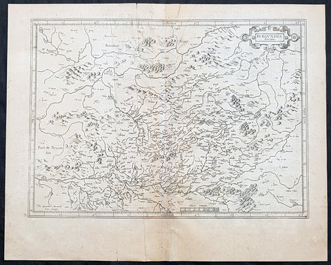
1628 Gerard Mercator Antique Map of The Burgundy Region of France
- Title : Burgundia Ducatus
- Size: 21in x 17in (530mm x 430mm)
- Condition: (A) Very Good Condition
- Date : 1628
- Ref #: 26143
Description:
This original copper plate engraved antique map of of the historical region of the Free County of Burgundy (Franche Comte de Bourgogne) of eastern France by Gerard Mercator was published by Henricus Hondius in the early 1628 French edition of Gerard Mercators Atlas.
These maps, published in the early editions of Mercators atlas, are the original maps drawn and engraved by Gerald Mercator in the mid to late 16th century, published by his son Rumold as an atlas, after his death, in 1595. After two editions the plates were purchased by Jodocus Hondius in 1604 and continued to be published until the mid 1630\\\'s when the plates were re-engraved and updated by Jan Jansson and Henricus Hondius.
General Definitions:
Paper thickness and quality: - Heavy and stable
Paper color : - off white
Age of map color: -
Colors used: -
General color appearance: -
Paper size: - 21in x 17in (530mm x 430mm)
Plate size: - 20in x 15in (510mm x 380mm)
Margins: - Min 1/2in (12mm)
Imperfections:
Margins: - Age toning, light creasing
Plate area: - Age toning, light creasing
Verso: - Age toning, light creasing
Background:
Burgundy is a historical territory and a former administrative region of France. It takes its name from the Burgundians, an East Germanic people who moved westwards beyond the Rhine during the late Roman period.
Historically, Burgundy has referred to numerous political entities, including kingdoms and duchies spanning territory from the Mediterranean to the Low Countries.
The first recorded inhabitants of the area that became Burgundy were Celts, who were eventually incorporated in the Roman Empire as Gallo-Romans.
During the 4th century, the Burgundians, a Germanic people, who may have originated in Bornholm (on the Baltic Sea), settled in the western Alps. They founded the Kingdom of the Burgundians, which was conquered in the 6th century by another Germanic tribe, the Franks.
Later, the region was divided between the Duchy of Burgundy (to the west) and the Free County of Burgundy (to the east). The Duchy of Burgundy is the better-known of the two, later becoming the French province of Burgundy, while the County of Burgundy became the French province of Franche-Comté, literally meaning free county.
Burgundys modern existence is rooted in the dissolution of the Frankish Empire. In the 880s, there were four Burgundies, which were the Kingdom of Upper and Lower Burgundy, the duchy and the county.
During the Middle Ages, Burgundy was home to some of the most important Western churches and monasteries, including those of Cluny, Cîteaux, and Vézelay. Cluny, founded in 910, exerted a strong influence in Europe for centuries. The first Cistercian abbey was founded in 1098 in Cîteaux. Over the next century, hundreds of Cistercian abbeys were founded throughout Europe, in a large part due to the charisma and influence of Bernard of Clairvaux. The Abbey of Fontenay, a UNESCO World Heritage site, is today the best-preserved Cistercian abbey in Burgundy. The Abbey of Vezelay, also a UNESCO site, is still a starting point for pilgrimages to Santiago de Compostela. Cluny was almost totally destroyed during the French Revolution.
During the Hundred Years War, King John II of France gave the duchy to his youngest son, Philip the Bold. The duchy soon became a major rival to the crown. The court in Dijon outshone the French court both economically and culturally. In 1477, at the battle of Nancy during the Burgundian Wars, the last duke Charles the Bold was killed in battle, and the Duchy itself was annexed by France and became a province. However the northern part of the empire was taken by the Austrian Habsburgs.
With the French Revolution in the end of the 18th century, the administrative units of the provinces disappeared, but were reconstituted as regions during the Fifth Republic in the 1970s. The modern-day administrative region comprises most of the former duchy.
1628 Gerard Mercator Antique Map the Franche Comte de Bourgogne Region of France
- Title : La Haute Bourgoigne...Per Geradum Mercatorem Cum Privilegio
- Size: 21in x 17in (530mm x 430mm)
- Condition: (A) Very Good Condition
- Date : 1628
- Ref #: 26144
Description:
This original copper plate engraved antique map of of the historical region of the Free County of Burgundy (Franche Comte de Bourgogne) of eastern France by Gerard Mercator was published by Henricus Hondius in the early 1628 French edition of Gerard Mercators Atlas.
These maps, published in the early editions of Mercators atlas, are the original maps drawn and engraved by Gerald Mercator in the mid to late 16th century, published by his son Rumold as an atlas, after his death, in 1595. After two editions the plates were purchased by Jodocus Hondius in 1604 and continued to be published until the mid 1630\\\'s when the plates were re-engraved and updated by Jan Jansson and Henricus Hondius.
General Definitions:
Paper thickness and quality: - Heavy and stable
Paper color : - off white
Age of map color: -
Colors used: -
General color appearance: -
Paper size: - 21in x 17in (530mm x 430mm)
Plate size: - 20in x 15in (510mm x 380mm)
Margins: - Min 1/2in (12mm)
Imperfections:
Margins: - Age toning
Plate area: - Age toning
Verso: - Age toning
Background:
The Free County of Burgundy (French: Franche Comté de Bourgogne; German: Freigrafschaft Burgund) was a medieval county (from 982 to 1678) of the Holy Roman Empire, within the modern region of Bourgogne-Franche-Comté, whose very name is still reminiscent of the title of its count: Freigraf (\\\'free count\\\', denoting imperial immediacy, or franc comte in French, hence the term franc(he) comté for his feudal principality). It should not be confused with the more westerly Duchy of Burgundy, a fiefdom of Francia since 843.
1628 Gerard Mercator Antique Map the Southern Lorraine Region of France
- Title : La Partie Meridionale de Lorraine...Per Geradum Mercatorem Cum Privilegio
- Size: 21in x 17in (530mm x 430mm)
- Condition: (A) Very Good Condition
- Date : 1628
- Ref #: 26142
Description:
This original copper plate engraved antique map ancient region of southern Lorraine, France by Gerard Mercator was published by Henricus Hondius in the early 1628 French edition of Gerard Mercators Atlas.
These maps, published in the early editions of Mercators atlas, are the original maps drawn and engraved by Gerald Mercator in the mid to late 16th century, published by his son Rumold as an atlas, after his death, in 1595. After two editions the plates were purchased by Jodocus Hondius in 1604 and continued to be published until the mid 1630\\\'s when the plates were re-engraved and updated by Jan Jansson and Henricus Hondius.
General Definitions:
Paper thickness and quality: - Heavy and stable
Paper color : - off white
Age of map color: -
Colors used: -
General color appearance: -
Paper size: - 21in x 17in (530mm x 430mm)
Plate size: - 20in x 15in (510mm x 380mm)
Margins: - Min 1/2in (12mm)
Imperfections:
Margins: - Age toning
Plate area: - Age toning
Verso: - Age toning
Lorraine is a cultural and historical region in north-eastern France, now located in the administrative region of Grand Est. Lorraines name stems from the medieval kingdom of Lotharingia, which in turn was named for either Emperor Lothair I or King Lothair II. It later was ruled as the Duchy of Lorraine before the Kingdom of France annexed it in 1766.

1628 Gerard Mercator Original Antique Map of Ireland - Irlandiae Regnum
- Title : Irlandiae regnum
- Date : 1628
- Ref: 61003
- Size: 22 1/2in x 19in (570mm x 485mm)
- Condition: (A+) Fine Condition
Description:
This fine beautifully hand coloured original antique map of Ireland by Gerald Mercator was published by Rumold Mercator & Jodocus Hondius in the early 1628 French edition of Mercators Atlas.
This map is magnificent with beautiful original hand colouring, large original margins with a heavy impression on clean, stable paper. Original colouring such as this is scarce and hard to find.
These maps, published in the early editions of Mercators atlas, are the original maps drawn and engraved by Gerald Mercator in the mid to late 16th century and were published by his sons Rumold & Henricus, after his death in 1595. After two editions the plates were purchased by Jodocus Hondius in 1604. He continued to publish them until the mid 1630\'s when some of the plates were re-engraved or replaced by Jan Jansson and Henricus Hondius.
General Definitions:
Paper thickness and quality: - Heavy and stable
Paper color : - off white
Age of map color: - Original
Colors used: - Orange, yellow, blue, red
General color appearance: - Authentic
Paper size: - 22 1/2in x 19in (570mm x 485mm)
Plate size: - 17 1/2in x 14in (420mm x 330mm)
Margins: - Min 2in (50mm)
Imperfections:
Margins: - None
Plate area: - None
Verso: - None
Background:
The earliest maps of Ireland up to the year 1500 or so share the shortcomings of those of the rest of the British Isles especially as represented on world maps. It was not to be expected that lands literally on the very edge of the known world could be depicted with any accuracy; very often one feels that the cartographers or engravers placed the islands in the nearest available space consistent with their imagined position. Even in the first printed Ptolemaic map there is still much distortion in Ireland\'s shape and geographical position but, on the other hand, a quite surprising number of place names and other details are shown, as many, in fact, as in the rest of Britain put together. This detailed knowledge is not as puzzling as it might appear, for the Ptolemy maps, at least the later editions from 1513 onwards, were based on Italian portulan charts and these, in turn, reflected knowledge gained during the long commercial relationship which had existed between Italy and Ireland ever since the thirteenth century. The distortions on land-surveyed maps remained uncorrected until late in the seventeenth century but a quite accurate coastal outline was given in the marine atlases of Waghenaer, Dudley, Blaeu and later Dutch chart makers.
Apart from a few manuscript maps and very rare maps printed in Rome and Venice (George Lily, 1546, and others in the period 1560-66) Ireland is shown on Mercator\'s large map of the British Isles (1564), and in his Atlas (1595) and as a separate sheet in the Ortelius atlases (from 1 573). The most important map, however, was compiled by an Italian, Baptista Boazio, probably in the 1 5 8os. This has survived in manuscript form and may have been used by Pieter van der Keere for a map published by Jodocus Hondius in 1591. Boazio\'s map was subsequently published by John Sudbury, who later sold Speed\'s maps, and this version was included in editions of the Ortelius atlases from 6oz onwards. The Boazio map is a quite splendid map, very decorative, some copies even showing an Eskimo complete with kayak and hunting spear. Thereafter the trend is familiar: Camden, Speed, Blaeu, Jansson, Sanson and others of the Dutch and French schools all included a general map or maps of the Irish provinces in their atlases. Speed\'s map of the whole of Ireland was based at least partly on surveys by Robert Lythe (c.1570) and Francis Jobson (c.1590) and included figures in national costume; it was for long regarded as the best map available and was much copied by publishers in other countries.
In 1685 the first atlas of Ireland to match Saxton\'s At/as of Eng/andand Wales was published by Sir William Petty as Hiberniae Detineaho, the result of a highly organized and detailed survey (the \'Down\' survey) carried out in the years following 1655. Re-issued in miniature form soon afterwards by Francis Lamb, Petty\'s Atlas was widely used as the basis for practically all maps of Ireland produced by English, French, Dutch and German publishers in the following century. Apart from re-issues of Petty\'s Atlas and its many copyists there were maps by George Grierson, a Dublin publisher, John Rocque, the Huguenot surveyor and engraver who spent some years in Dublin, and Bernard Scale, Rocque\'s brother-in-law.
Towards the end of the century many large-scale maps were published but, as in England, private mapping was gradually overtaken and eventually replaced by the Ordnance Survey maps produced between the years 1824 and 1846.(Ref: Koeman, Tooley)
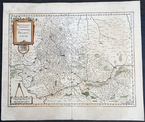
1628 Henricus Hondius Antique Map Beauvais Region of Northern France, Oise River
- Title : Beauvaisis Comitatus Belovacium
- Size: 22in x 18 1/2in (560mm x 470mm)
- Condition: (A) Very Good Condition
- Date : 1628
- Ref #: 50230
Description:
This original hand coloured copper plate engraved antique map of the Beauvais region of Northern France - centering on the city of Beauvais & the Oise River running through the cities of Noyon, Compiègne, Creil, by Henricus Hondius was published by Henricus Hondius & Jan Jansson in the 1628 French edition of Gerard Mercators Atlas.
General Definitions:
Paper thickness and quality: - Heavy and stable
Paper color : - off white
Age of map color: - Original
Colors used: - Blue, pink, red, green, yellow
General color appearance: - Authentic
Paper size: - 22in x 18 1/2in (560mm x 470mm)
Plate size: - 20in x 15in (510mm x 380mm)
Margins: - Min 1in (25mm)
Imperfections:
Margins: - Age toning
Plate area: - Age toning
Verso: - Age toning
Background:
Beauvais is a city and commune in northern France. It serves as the capital of the Oise département, in the Hauts-de-France region. Beauvais is located approximately 75 kilometres from Paris.
Beauvais was known to the Romans by the Gallo-Roman name of Caesaromagus (magos is Common Celtic for field). The post-Renaissance Latin rendering is Bellovacum from the Belgic tribe the Bellovaci, whose capital it was. In the ninth century it became a countship, which about 1013 passed to the bishops of Beauvais, who became peers of France from the twelfth century. At the coronations of kings the Bishop of Beauvais wore the royal mantle and went, with the Bishop of Langres, to raise the king from his throne to present him to the people.
De Bello Gallico II 13 reports that as Julius Caesar was approaching a fortified town called Bratuspantium in the land of the Bellovaci, its inhabitants surrendered to him when he was about 5 Roman miles away. Its name is Gaulish for place where judgements are made, from *bratu-spantion. Some say that Bratuspantium is Beauvais. Others theorize that it is Vendeuil-Caply or Bailleul sur Thérain.
From 1004 to 1037, the Count of Beauvais was Odo II, Count of Blois.
In a charter dated 1056/1060, Eudo of Brittany granted land in pago Belvacensi (Beauvais, Picardy) to the Abbey of Angers Saint-Aubin
In 1346 the town had to defend itself against the English, who again besieged it in 1433. The siege which it endured in 1472 at the hands of the Duke of Burgundy, was rendered famous by the heroism of the towns women, under the leadership of Jeanne Hachette, whose memory is still celebrated by a procession on 27 June (the feast of Sainte Angadrême), during which women take precedence over men.
An interesting hoard of coins from the High Middle Ages became known as the Beauvais Hoard, because some of the British and European coins found with the lot were from the French abbey located in Beauvais. The hoard, which contained a variety of rare and extremely rare Anglo-Norman pennies, English and foreign coins, was reputed to have been found in or near Paris.
Please note all items auctioned are genuine, we do not sell reproductions. A Certificate of Authenticity (COA) can be issued on request.
1628 Henricus Hondius Antique Map of South America, inset of Cusco - Beautiful
Antique Map
- Title : America Meridionalis
- Date : 1628
- Size: 22in x 18 1/2in (560mm x 470mm)
- Condition: (A+) Fine Condition
- Ref: 35645
Description:
This superb, original antique hand coloured folio map of South America, was engraved by Jodocus Hondius & published by his son Henricus for the continuation of Gerard Mercators 1628 French edition of Atlas.
This map is in superb condition with beautiful hand colouring, a deep heavy imprint denoting an early pressing on clean, heavy paper. Original margins, one of the best I have seen for sometime.
General Definitions:
Paper thickness and quality: - Heavy and stable
Paper color : - off white
Age of map color: - Early
Colors used: - Yellow, green, blue, pink
General color appearance: - Authentic
Paper size: - 22in x 18 1/2in (560mm x 470mm)
Plate size: - 19 1/2in x 14 1/4in (495mm x 363mm)
Margins: - Min 1in (25mm)
Imperfections:
Margins: - None
Plate area: - None
Verso: - None
Background:
The interior of the map is dominated by the large mythical lake Parime Lacus straddling the equator below Venezuela along with an interesting & mythical continental river system. The huge Rio de la Plata river flows south from the conjectural Eupana Lacus in Brazil, while the R. Grande flows north from the same lake, ostensibly making Brazil an island.
The Strait of Magellan is represented, but Tierra del Fuego (Fogo) is named as part of the mythical Great Southern Land instead of an island.
The map is beautifully engraved with a stippled wave pattern Pacific & Atlantic Oceans, filled with Spanish & English ships, sea monsters and native canoe. The continent is flanked by two elaborate Baroque cartouches; title to the right and a large inset plan of the Capital of the Ancient Incan Empire, Cuzco. A sole representation of the conquered Native Americans is engraved as a lone Indian with a bow and arrow in the interior of Patgonia.
Between 1452 and 1493, a series of papal bulls (Dum Diversas, Romanus Pontifex, and Inter caetera) paved the way for the European colonization and Catholic missions in the New World. These authorized the European Christian nations to \"take possession\" of non-Christian lands and encouraged subduing and converting the non-Christian people of Africa and the Americas.
In 1494, Portugal and Spain, the two great maritime powers of that time, signed the Treaty of Tordesillas in the expectation of new lands being discovered in the west. Through the treaty they agreed that all the land outside Europe should be an exclusive duopoly between the two countries. The treaty established an imaginary line along a north-south meridian 370 leagues west of Cape Verde Islands, roughly 46° 37\' W. In terms of the treaty, all land to the west of the line (which is now known to include most of the South American soil), would belong to Spain, and all land to the east, to Portugal. Because accurate measurements of longitude were not possible at that time, the line was not strictly enforced, resulting in a Portuguese expansion of Brazil across the meridian.
In 1498, during his third voyage to the Americas, Christopher Columbus sailed near the Orinoco Delta and then landed in the Gulf of Paria (Actual Venezuela). Amazed by the great offshore current of freshwater which deflected his course eastward, Columbus expressed in his moving letter to Isabella I and Ferdinand II that he must have reached heaven on Earth (terrestrial paradise):
Great signs are these of the Terrestrial Paradise, for the site conforms to the opinion of the holy and wise theologians whom I have mentioned. And likewise, the [other] signs conform very well, for I have never read or heard of such a large quantity of fresh water being inside and in such close proximity to salt water; the very mild temperateness also corroborates this; and if the water of which I speak does not proceed from Paradise then it is an even greater marvel, because I do not believe such a large and deep river has ever been known to exist in this world.
Beginning in 1499, the people and natural resources of South America were repeatedly exploited by foreign conquistadors, first from Spain and later from Portugal. These competing colonial nations claimed the land and resources as their own and divided it into colonies.
European diseases (smallpox, influenza, measles and typhus) to which the native populations had no resistance were the overwhelming cause of the depopulation of the Native American population. Cruel systems of forced labor (such as encomiendas and mining industry\'s mita) under Spanish control also contributed to depopulation. Lower bound estimates speak of a decline in the population of around 20–50 per cent, whereas high estimates arrive at 90 per cent.[42] Following this, African slaves, who had developed immunity to these diseases, were quickly brought in to replace them.
The Spaniards were committed to converting their American subjects to Christianity and were quick to purge any native cultural practices that hindered this end. However, most initial attempts at this were only partially successful; American groups simply blended Catholicism with their traditional beliefs. The Spaniards did not impose their language to the degree they did their religion. In fact, the missionary work of the Roman Catholic Church in Quechua, Nahuatl, and Guarani actually contributed to the expansion of these American languages, equipping them with writing systems.
Eventually the natives and the Spaniards interbred, forming a Mestizo class. Mestizos and the Native Americans were often forced to pay unfair taxes to the Spanish government (although all subjects paid taxes) and were punished harshly for disobeying their laws. Many native artworks were considered pagan idols and destroyed by Spanish explorers. This included a great number of gold and silver sculptures, which were melted down before transport to Europe.
In 1616, the Dutch, attracted by the legend of El Dorado, founded a fort in Guayana and established three colonies: Demerara, Berbice, and Essequibo.
In 1624 France attempted to settle in the area of modern-day French Guiana, but was forced to abandon it in the face of hostility from the Portuguese, who viewed it as a violation of the Treaty of Tordesillas. However French settlers returned in 1630 and in 1643 managed to establish a settlement at Cayenne along with some small-scale plantations.
Since the sixteenth century there were some movements of discontent to Spanish and Portuguese colonial system. Among these movements, the most famous being that of the Maroons, slaves who escaped their masters and in the shelter of the forest communities organized free communities. Attempts to subject them by the royal army was unsuccessful, because the Maroons had learned to master the South American jungles. In a royal decree of 1713, the king gave legality to the first free population of the continent: Palenque de San Basilio in Colombia today, led by Benkos Bioho. Brazil saw the formation of a genuine African kingdom on their soil, with the Quilombo of Palmares.
Between 1721 and 1735, the Revolt of the Comuneros of Paraguay arose, because of clashes between the Paraguayan settlers and the Jesuits, who ran the large and prosperous Jesuit Reductions and controlled a large number of Christianized Indians.
Between 1742 and 1756, was the insurrection of Juan Santos Atahualpa in the central jungle of Peru. In 1780, the Viceroyalty of Peru was met with the insurrection of curaca Condorcanqui or Tupac Amaru II, which would be continued by Tupac Catari in Upper Peru.
In 1763, the African Cuffy led a revolt in Guyana which was bloodily suppressed by the Dutch. In 1781, the Revolt of the Comuneros (New Granada), an insurrection of the villagers in the Viceroyalty of New Granada, was a popular revolution that united indigenous people and mestizos. The villagers tried to be the colonial power and despite the capitulation were signed, the Viceroy Manuel Antonio Flores did not comply, and instead ran to the main leaders José Antonio Galán. In 1796, Essequibo (colony) of the Dutch was taken by the British, who had previously begun a massive introduction of slaves.
During the eighteenth century, the figure of the priest, mathematician and botanist José Celestino Mutis (1732–1808), was delegated by the Viceroy Antonio Caballero y Gongora to conduct an inventory of the nature of the Nueva Granada, which became known as the Botanical Expedition, which classified plants, wildlife and founded the first astronomical observatory in the city of Santa Fé de Bogotá.
On August 15, 1801, the Prussian scientist Alexander von Humboldt reached Fontibón where Mutis, and began his expedition to New Granada, Quito. The meeting between the two scholars are considered the brightest spot of the botanical expedition. Humboldt also visited Venezuela, Mexico, United States, Chile, and Peru. Through his observations of temperature differences between the Pacific Ocean between Chile and Peru in different periods of the year, he discovered cold currents moving from south to north up the coast of Peru, which was named the Humboldt Current in his honour.
Between 1806 and 1807, British military forces tried to invade the area of the Rio de la Plata, at the command of Home Riggs Popham and William Carr Beresford, and John Whitelocke. The invasions were repelled, but powerfully affected the Spanish authority.
1628 Henricus Hondius Antique Map of the Basque Region of Spain
Antique Map
- Title : Legionis, Biscaiae Et Guipiscoae Typus
- Date : 1628
- Size: 22 1/2in x 18 1/2in (570mm x 470mm)
- Condition: (A+) Fine Condition
- Ref: 35641
Description:
This beautifully engraved hand coloured original antique map of Basque Region of Spain was published in the 1628 French edition of Mercator's atlas by Jan Jansson and Henricus Hondius.
These maps, published in the later editions of Mercators atlas, are derived from the original maps drawn and engraved by Gerald Mercator in the mid to late 16th century, published by his son Rumold as an atlas, after his death, in 1595. After two editions the plates were purchased by Jodocus Hondius in 1604 and continued to be published until the mid 1630's when the plates were re-engraved and updated by Jan Jansson and Henricus Hondius.
General Definitions:
Paper thickness and quality: - Heavy and stable
Paper color : - off white
Age of map color: - Original & later
Colors used: - Yellow, green, pink
General color appearance: - Authentic
Paper size: - 22 3/4in x 19 3/4in (580mm x 500mm)
Plate size: - 20in x 13 3/4in (500mm x 350mm)
Margins: - Min 1in (25mm)
Imperfections:
Margins: - None
Plate area: - None
Verso: - None
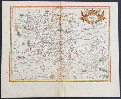
1628 Henricus Hondius Antique Map of the Duchy of Anjou, Maine-et-Loire, France
- Title : Aniov
- Date : 1628
- Size: 21in x 17in (535mm x 430mm)
- Ref #: 26135
- Condition: (A) Very Good Condition
Description:
This beautifully hand coloured original copper-plate engraved antique map of the French region of the historical province of Anjou (today a greater part of the Maine-et-Loire dept.) centering on the city of Angers & the Loire River was published in the 1628 French edition of Mercators Atlas by Henricus Hondius and Jan Jansson.
General Definitions:
Paper thickness and quality: - Heavy and stable
Paper color : - off white
Age of map color: - Original
Colors used: - Yellow, green, blue, pink
General color appearance: - Authentic
Paper size: - 21in x 17in (535mm x 430mm)
Plate size: - 18in x 14in (460mm x 360mm)
Margins: - Min 1/2in (12mm)
Imperfections:
Margins: - None
Plate area: - Age toning along centerfold
Verso: - Age toning along centerfold
Background:
Anjou is a historical province of France straddling the lower Loire River. Its capital was Angers and it was roughly coextensive with the diocese of Angers. It bordered Brittany to the west, Maine to the north, Touraine to the east and Poitou to the south. The adjectival form of Anjou is Angevin and inhabitants of Anjou are known as Angevins. During the Middle Ages, the county of Anjou was a prominent fief of the French crown.
The region takes its name from the Celtic tribe of the Andecavi, who submitted to Roman rule following the Gallic Wars. Under the Romans, the chief fortified settlement of the Andecavi became the city of Juliomagus, the future Angers. The territory of the Andecavi was organized as a civitas (called the civitas Andegavensis or civitas Andegavorum).
Under the Franks, the city of Juliomagus took the name of the ancient tribe and became Angers. Under the Merovingians, the history of Anjou is obscure. It is not recorded as a county (comitatus) until the time of the Carolingians. In the late ninth and early tenth centuries the viscounts (representatives of the counts) usurped comital authority and made Anjou an autonomous hereditary principality. The first dynasty of counts of Anjou, the House of Ingelger, ruled continuously down to 1205. In 1131, Count Fulk V became the King of Jerusalem; then in 1154, his grandson, Henry \'Curtmantle\' became King of England. The territories ruled by Henry and his successors, which stretched from Ireland to the Pyrenees, are often called the Angevin Empire. This empire was broken up by the French king Philip II, who confiscated the dynasty\'s French lands, including Anjou in 1205.
The county of Anjou was united to the royal domain between 1205 and 1246, when it was turned into an apanage for the king\'s brother, Charles I of Anjou. This second Angevin dynasty, a branch of the Capetian dynasty, established itself on the throne of Naples and Hungary. Anjou itself was united to the royal domain again in 1328, but was detached in 1360 as the Duchy of Anjou for the king\'s son, Louis I of Anjou. The third Angevin dynasty, a branch of the House of Valois, also ruled for a time the Kingdom of Naples. The dukes had the same autonomy as the earlier counts, but the duchy was increasingly administered in the same fashion as the royal domain and the royal government often exercised the ducal power while the dukes were away. When the Valois line failed and Anjou was incorporated into the royal domain again in 1480, there was little change on the ground. Anjou remained a province of crown until the French Revolution (1790), when the provinces were reorganized.
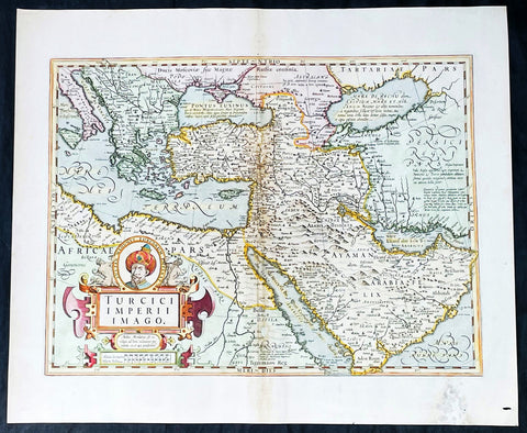
1628 Henricus Hondius Antique Map Ottoman Empire Saudi Arabia to Southern Europe
Antique Map
- Title : Turcici Imperii Imago
- Date : 1628
- Size: 22 1/2in x 18 1/2in (570mm x 470mm)
- Condition: (A-) Good Condition
- Ref: 35642
Description:
This beautifully engraved hand coloured original antique map of The Ottoman Empire in the mid 17th century from Saudi Arabia to southern Europe was published in the 1628 French edition of Mercator's atlas by Jan Jansson and Henricus Hondius.
These maps, published in the later editions of Mercators atlas, are derived from the original maps drawn and engraved by Gerald Mercator in the mid to late 16th century, published by his son Rumold as an atlas, after his death, in 1595. After two editions the plates were purchased by Jodocus Hondius in 1604 and continued to be published until the mid 1630's when the plates were re-engraved and updated by Jan Jansson and Henricus Hondius.
General Definitions:
Paper thickness and quality: - Heavy and stable
Paper color : - off white
Age of map color: - Original & later
Colors used: - Yellow, green, pink
General color appearance: - Authentic
Paper size: - 22 3/4in x 19 3/4in (580mm x 500mm)
Plate size: - 20in x 13 3/4in (500mm x 350mm)
Margins: - Min 1in (25mm)
Imperfections:
Margins: - Light soiling, small wormhole, light creasing
Plate area: - Small loss and creasing along centerfold
Verso: - Light soiling and creasing
Background:
The Ottoman Empire also historically known in Western Europe as the Turkish Empire or simply Turkey, was a state that controlled much of Southeast Europe, Western Asia and North Africa between the 14th and early 20th centuries. It was founded at the end of the 13th century in northwestern Anatolia in the town of Söğüt (modern-day Bilecik Province) by the Oghuz Turkish tribal leader Osman I. After 1354, the Ottomans crossed into Europe, and with the conquest of the Balkans, the Ottoman beylik was transformed into a transcontinental empire. The Ottomans ended the Byzantine Empire with the 1453 conquest of Constantinople by Mehmed the Conqueror.
During the 16th and 17th centuries, at the height of its power under the reign of Suleiman the Magnificent, the Ottoman Empire was a multinational, multilingual empire controlling most of Southeast Europe, parts of Central Europe, Western Asia, parts of Eastern Europe and the Caucasus, North Africa and the Horn of Africa. At the beginning of the 17th century, the empire contained 32 provinces and numerous vassal states. Some of these were later absorbed into the Ottoman Empire, while others were granted various types of autonomy during the course of centuries.
With Constantinople as its capital and control of lands around the Mediterranean basin, the Ottoman Empire was at the centre of interactions between the Eastern and Western worlds for six centuries. While the empire was once thought to have entered a period of decline following the death of Suleiman the Magnificent, this view is no longer supported by the majority of academic historians. The empire continued to maintain a flexible and strong economy, society and military throughout the 17th and much of the 18th century. However, during a long period of peace from 1740 to 1768, the Ottoman military system fell behind that of their European rivals, the Habsburg and Russian empires. The Ottomans consequently suffered severe military defeats in the late 18th and early 19th centuries, which prompted them to initiate a comprehensive process of reform and modernisation known as the Tanzimat. Thus, over the course of the 19th century, the Ottoman state became vastly more powerful and organised, despite suffering further territorial losses, especially in the Balkans, where a number of new states emerged. The empire allied with Germany in the early 20th century, hoping to escape from the diplomatic isolation which had contributed to its recent territorial losses, and thus joined World War I on the side of the Central Powers. While the Empire was able to largely hold its own during the conflict, it was struggling with internal dissent, especially with the Arab Revolt in its Arabian holdings. During this time, atrocities were committed by the Ottoman government against the Armenians, Assyrians and Pontic Greeks.
The Empire\'s defeat and the occupation of part of its territory by the Allied Powers in the aftermath of World War I resulted in its partitioning and the loss of its Middle Eastern territories, which were divided between the United Kingdom and France. The successful Turkish War of Independence against the occupying Allies led to the emergence of the Republic of Turkey in the Anatolian heartland and the abolition of the Ottoman monarchy.
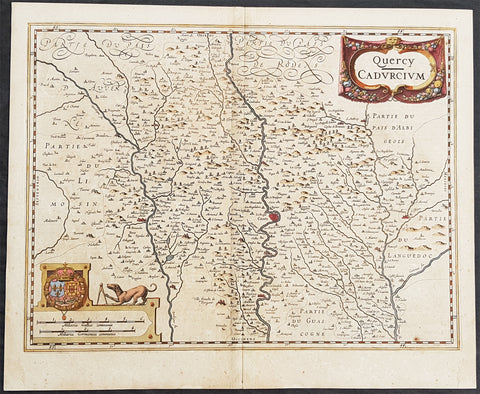
1628 Henricus Hondius Antique Map The Province of Quercy, Lot, Cahors, SW France
- Title : Quercy - Cadurcium
- Ref #: 26140
- Size: 21 1/2in x 17 1/2in (490mm x 340mm)
- Date : 1628
- Condition: (A) Very Good Condition
Description:
This beautifully hand coloured original copper-plate engraved antique map of the ancient province of Quercy located in southwest France - centering on the city of Cahors & the River Lot - was published in the 1628 French edition of Mercators Atlas by Henricus Hondius and Jan Jansson.
General Definitions:
Paper thickness and quality: - Heavy and stable
Paper color : - off white
Age of map color: - Original
Colors used: - Yellow, green, blue, pink
General color appearance: - Authentic
Paper size: - 21 1/2in x 17 1/2in (490mm x 340mm)
Plate size: - 20in x 15in (510mm x 380mm)
Margins: - Min 1/2in (12mm)
Imperfections:
Margins: - Light age toning
Plate area: - Age toning along centerfold
Verso: - Age toning along centerfold
Background:
Quercy is a former province of France located in the countrys southwest, bounded on the north by Limousin, on the west by Périgord and Agenais, on the south by Gascony and Languedoc, and on the east by Rouergue and Auvergne.
Under the Romans Quercy was part of Aquitania prima, and Christianity was introduced during the 4th century. Early in the 6th century it fell under the authority of the Franks, and in the 7th century became part of the autonomous Duchy of Aquitaine. At the end of the 10th century its rulers were the powerful counts of Toulouse. During the wars between England and France in the reign of Henry II, the English placed garrisons in the county, and by the 1259 Treaty of Paris lower Quercy was ceded to England. The monarchs of both England and France confirmed and added to the privileges of the towns and the district, each thus hoping to attach the inhabitants to his own interest. In 1360, by the Treaty of Bretigny, the whole county passed to England, but in 1440 the English were finally expelled. In the 16th century Quercy was a stronghold of the Protestants, and the scene of a savage religious warfare. The civil wars of the reign of Louis XIII largely took place around Montauban.
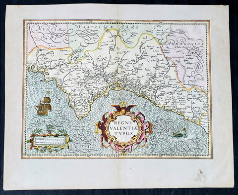
1628 Henricus Hondius Antique Map Valencia Region of Spain & Mediterranean Sea
Antique Map
- Title : Regni Valentiae Typus
- Date : 1628
- Size: 22 1/2in x 18 1/2in (570mm x 470mm)
- Condition: (A+) Fine Condition
- Ref: 35640
Description:
This beautifully engraved hand coloured original antique map of Valencia Region of Spain was published in the 1628 French edition of Mercator's atlas by Jan Jansson and Henricus Hondius.
These maps, published in the later editions of Mercators atlas, are derived from the original maps drawn and engraved by Gerald Mercator in the mid to late 16th century, published by his son Rumold as an atlas, after his death, in 1595. After two editions the plates were purchased by Jodocus Hondius in 1604 and continued to be published until the mid 1630's when the plates were re-engraved and updated by Jan Jansson and Henricus Hondius.
General Definitions:
Paper thickness and quality: - Heavy and stable
Paper color : - off white
Age of map color: - Original & later
Colors used: - Yellow, green, pink
General color appearance: - Authentic
Paper size: - 22 3/4in x 19 3/4in (580mm x 500mm)
Plate size: - 20in x 13 3/4in (500mm x 350mm)
Margins: - Min 1in (25mm)
Imperfections:
Margins: - Light soiling
Plate area: - None
Verso: - None
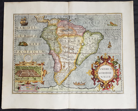
1628 Henricus Hondius Original Antique Map of South America
- Title : America Meridionalis
- Date : 1628
- Size: 23in x 18 3/4in (585mm x 475mm)
- Ref #: 70817
- Condition: (A+) Fine Condition
Description:
This superb, original antique hand coloured folio map of South America, was engraved by Jodocus Hondius & published by his son Henricus for the continuation of Gerard Mercators 1628 French edition of Atlas.
This map is in superb condition with beautiful hand colouring, a deep heavy imprint denoting an early pressing on clean, heavy paper. Original margins, one of the best I have seen for sometime.
General Definitions:
Paper thickness and quality: - Heavy and stable
Paper color : - off white
Age of map color: - Early
Colors used: - Yellow, green, blue, pink
General color appearance: - Authentic
Paper size: - 23in x 18 3/4in (585mm x 475mm)
Plate size: - 19 1/2in x 14 1/4in (495mm x 363mm)
Margins: - Min 1in (25mm)
Imperfections:
Margins: - None
Plate area: - 4 very small worm holes
Verso: - None
Background:
The interior of the map is dominated by the large mythical lake Parime Lacus straddling the equator below Venezuela along with an interesting & mythical continental river system. The huge Rio de la Plata river flows south from the conjectural Eupana Lacus in Brazil, while the R. Grande flows north from the same lake, ostensibly making Brazil an island.
The Strait of Magellan is represented, but Tierra del Fuego (Fogo) is named as part of the mythical Great Southern Land instead of an island.
The map is beautifully engraved with a stippled wave pattern Pacific & Atlantic Oceans, filled with Spanish & English ships, sea monsters and native canoe. The continent is flanked by two elaborate Baroque cartouches; title to the right and a large inset plan of the Capital of the Ancient Incan Empire, Cuzco. A sole representation of the conquered Native Americans is engraved as a lone Indian with a bow and arrow in the interior of Patgonia.
Between 1452 and 1493, a series of papal bulls (Dum Diversas, Romanus Pontifex, and Inter caetera) paved the way for the European colonization and Catholic missions in the New World. These authorized the European Christian nations to \"take possession\" of non-Christian lands and encouraged subduing and converting the non-Christian people of Africa and the Americas.
In 1494, Portugal and Spain, the two great maritime powers of that time, signed the Treaty of Tordesillas in the expectation of new lands being discovered in the west. Through the treaty they agreed that all the land outside Europe should be an exclusive duopoly between the two countries. The treaty established an imaginary line along a north-south meridian 370 leagues west of Cape Verde Islands, roughly 46° 37\' W. In terms of the treaty, all land to the west of the line (which is now known to include most of the South American soil), would belong to Spain, and all land to the east, to Portugal. Because accurate measurements of longitude were not possible at that time, the line was not strictly enforced, resulting in a Portuguese expansion of Brazil across the meridian.
In 1498, during his third voyage to the Americas, Christopher Columbus sailed near the Orinoco Delta and then landed in the Gulf of Paria (Actual Venezuela). Amazed by the great offshore current of freshwater which deflected his course eastward, Columbus expressed in his moving letter to Isabella I and Ferdinand II that he must have reached heaven on Earth (terrestrial paradise):
Great signs are these of the Terrestrial Paradise, for the site conforms to the opinion of the holy and wise theologians whom I have mentioned. And likewise, the [other] signs conform very well, for I have never read or heard of such a large quantity of fresh water being inside and in such close proximity to salt water; the very mild temperateness also corroborates this; and if the water of which I speak does not proceed from Paradise then it is an even greater marvel, because I do not believe such a large and deep river has ever been known to exist in this world.
Beginning in 1499, the people and natural resources of South America were repeatedly exploited by foreign conquistadors, first from Spain and later from Portugal. These competing colonial nations claimed the land and resources as their own and divided it into colonies.
European diseases (smallpox, influenza, measles and typhus) to which the native populations had no resistance were the overwhelming cause of the depopulation of the Native American population. Cruel systems of forced labor (such as encomiendas and mining industry\'s mita) under Spanish control also contributed to depopulation. Lower bound estimates speak of a decline in the population of around 20–50 per cent, whereas high estimates arrive at 90 per cent.[42] Following this, African slaves, who had developed immunity to these diseases, were quickly brought in to replace them.
The Spaniards were committed to converting their American subjects to Christianity and were quick to purge any native cultural practices that hindered this end. However, most initial attempts at this were only partially successful; American groups simply blended Catholicism with their traditional beliefs. The Spaniards did not impose their language to the degree they did their religion. In fact, the missionary work of the Roman Catholic Church in Quechua, Nahuatl, and Guarani actually contributed to the expansion of these American languages, equipping them with writing systems.
Eventually the natives and the Spaniards interbred, forming a Mestizo class. Mestizos and the Native Americans were often forced to pay unfair taxes to the Spanish government (although all subjects paid taxes) and were punished harshly for disobeying their laws. Many native artworks were considered pagan idols and destroyed by Spanish explorers. This included a great number of gold and silver sculptures, which were melted down before transport to Europe.
In 1616, the Dutch, attracted by the legend of El Dorado, founded a fort in Guayana and established three colonies: Demerara, Berbice, and Essequibo.
In 1624 France attempted to settle in the area of modern-day French Guiana, but was forced to abandon it in the face of hostility from the Portuguese, who viewed it as a violation of the Treaty of Tordesillas. However French settlers returned in 1630 and in 1643 managed to establish a settlement at Cayenne along with some small-scale plantations.
Since the sixteenth century there were some movements of discontent to Spanish and Portuguese colonial system. Among these movements, the most famous being that of the Maroons, slaves who escaped their masters and in the shelter of the forest communities organized free communities. Attempts to subject them by the royal army was unsuccessful, because the Maroons had learned to master the South American jungles. In a royal decree of 1713, the king gave legality to the first free population of the continent: Palenque de San Basilio in Colombia today, led by Benkos Bioho. Brazil saw the formation of a genuine African kingdom on their soil, with the Quilombo of Palmares.
Between 1721 and 1735, the Revolt of the Comuneros of Paraguay arose, because of clashes between the Paraguayan settlers and the Jesuits, who ran the large and prosperous Jesuit Reductions and controlled a large number of Christianized Indians.
Between 1742 and 1756, was the insurrection of Juan Santos Atahualpa in the central jungle of Peru. In 1780, the Viceroyalty of Peru was met with the insurrection of curaca Condorcanqui or Tupac Amaru II, which would be continued by Tupac Catari in Upper Peru.
In 1763, the African Cuffy led a revolt in Guyana which was bloodily suppressed by the Dutch. In 1781, the Revolt of the Comuneros (New Granada), an insurrection of the villagers in the Viceroyalty of New Granada, was a popular revolution that united indigenous people and mestizos. The villagers tried to be the colonial power and despite the capitulation were signed, the Viceroy Manuel Antonio Flores did not comply, and instead ran to the main leaders José Antonio Galán. In 1796, Essequibo (colony) of the Dutch was taken by the British, who had previously begun a massive introduction of slaves.
During the eighteenth century, the figure of the priest, mathematician and botanist José Celestino Mutis (1732–1808), was delegated by the Viceroy Antonio Caballero y Gongora to conduct an inventory of the nature of the Nueva Granada, which became known as the Botanical Expedition, which classified plants, wildlife and founded the first astronomical observatory in the city of Santa Fé de Bogotá.
On August 15, 1801, the Prussian scientist Alexander von Humboldt reached Fontibón where Mutis, and began his expedition to New Granada, Quito. The meeting between the two scholars are considered the brightest spot of the botanical expedition. Humboldt also visited Venezuela, Mexico, United States, Chile, and Peru. Through his observations of temperature differences between the Pacific Ocean between Chile and Peru in different periods of the year, he discovered cold currents moving from south to north up the coast of Peru, which was named the Humboldt Current in his honour.
Between 1806 and 1807, British military forces tried to invade the area of the Rio de la Plata, at the command of Home Riggs Popham and William Carr Beresford, and John Whitelocke. The invasions were repelled, but powerfully affected the Spanish authority
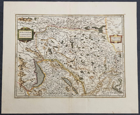
1628 Jan Jansson Antique Map Free County of Burgundy, Franche Comté de Bourgogne, France
- Title : Burgundiae Comitatus Franche Comte.
- Ref #: 50256
- Size: 23 1/2in x 20in (610mm x 510mm)
- Date : 1628
- Condition: (A+) Fine Condition
Description:
This beautifully hand coloured original copper-plate engraved antique map of the historical region of the Free County of Burgundy (Franche Comte de Bourgogne) of eastern France by Jan Jansson - was published in the 1628 edition of Mercators Atlas by Jan Jansson and Henricus Hondius.
General Definitions:
Paper thickness and quality: - Heavy and stable
Paper color : - off white
Age of map color: - Original
Colors used: - Yellow, green, blue, pink
General color appearance: - Authentic
Paper size: - 23 1/2in x 20in (610mm x 510mm)
Plate size: - 19 1/2in x 15 1/2in (500mm x 390mm)
Margins: - Min 2in (50mm)
Imperfections:
Margins: - None
Plate area: - None
Verso: - None
Background:
The Free County of Burgundy (French: Franche Comté de Bourgogne; German: Freigrafschaft Burgund) was a medieval county (from 982 to 1678) of the Holy Roman Empire, within the modern region of Bourgogne-Franche-Comté, whose very name is still reminiscent of the title of its count: Freigraf (\'free count\', denoting imperial immediacy, or franc comte in French, hence the term franc(he) comté for his feudal principality). It should not be confused with the more westerly Duchy of Burgundy, a fiefdom of Francia since 843.
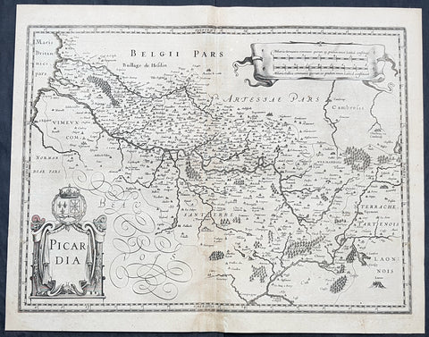
1628 Jan Jansson Antique Map of the Picardy or Picardie Region of France
- Title : Picardia
- Size: 22in x 17in (560mm x 430mm)
- Condition: (A) Very Good Condition
- Date : 1628
- Ref #: 26133
Description:
This original copper plate engraved antique map of the French region of Picardy or Picardie by Jan Jansson was published in the early 1628 French edition of Janssons Atlas.
General Definitions:
Paper thickness and quality: - Heavy and stable
Paper color : - off white
Age of map color: -
Colors used: -
General color appearance: -
Paper size: - 22in x 17in (560mm x 430mm)
Plate size: - 20in x 15in (510mm x 380mm)
Margins: - Min 1/2in (12mm)
Imperfections:
Margins: - Age toning
Plate area: - Age toning
Verso: - Age toning
Background:
Picardy is a historical territory and a former administrative region of Northern France and now part of the new region Nord-Pas-de-Calais-Picardie.
From the 5th century the area was part of the Frankish Empire, and in the feudal period it encompassed the six countships of Boulogne, Montreuil, Ponthieu, Amiénois,Vermandois, and Laonnois. According to the 843 Treaty of Verdun the region became part of West Francia, the later Kingdom of France.
The name Picardy (which may have referred to a Frankish tribe of picards or pike-bearers) was not used until the 12th or 13th century. During this time, the name applied to all lands where the Picard language was spoken, which included all the territories from Paris to the Netherlands. In the Latin Quarter of Paris, people identified a Picard Nation (Nation Picarde) of students at Sorbonne University, most of whom actually came from Flanders. During the Hundred Years\\\\\\\' War, Picardy was the centre of the Jacquerie peasant revolt in 1358.
From 1419 onwards, the Picardy counties (Boulogne, Ponthieu, Amiens, Vermandois) were gradually acquired by the Burgundian duke Philip the Good, confirmed by King Charles VII of France at the 1435 Congress of Arras. In 1477, King Louis XI of France led an army and occupied key towns in Picardy. By the end of 1477, Louis would control all of Picardy and most of Artois.
In the 16th century, the government (military region) of Picardy was created. This became a new administrative region of France, separate from what was historically defined as Picardy. The new Picardy included the Somme département, the northern half of the Aisne département, and a small fringe in the north of the Oise département.
In 1557, Picardy was invaded by Hapbsburg forces under the command of Emmanuel Philibert, Duke of Savoy. After a seventeen-day siege, St. Quentin would be ransacked while Noyon would be burned by the Habsburg army.
In the 17th century, an infectious disease similar to English sweat originated from the region and spread across France. It was called Suette des picards or Picardy sweat.
Sugar beet was introduced by Napoleon I during the Napoleonic Wars in the 19th century, in order to counter the United Kingdom, which had seized the sugar islands possessed by France in the Caribbean. The sugar industry has continued to play a prominent role in the economy of the region.
One of the most significant historical events to occur in Picardy was the series of battles fought along the Somme during World War I. From September 1914 to August 1918, four major battles, including the Battle of the Somme, were fought by British, French, and German forces in the fields of Northern Picardy. (Ref: Koeman; M&B; Tooley)
1628 Jan Jansson Antique Map of the Picardy Region of France
- Title : Picardia
- Size: 22in x 17in (560mm x 430mm)
- Condition: (B) Good Condition
- Date : 1628
- Ref #: 50241
Description:
This original copper plate engraved antique map of the French region of Picardy or Picardie by Jan Jansson was published in the early 1628 Latin edition of Janssons Atlas.
General Definitions:
Paper thickness and quality: - Heavy and stable
Paper color : - off white
Age of map color: -
Colors used: -
General color appearance: -
Paper size: - 22in x 17in (560mm x 430mm)
Plate size: - 20in x 15in (510mm x 380mm)
Margins: - Min 1/2in (12mm)
Imperfections:
Margins: - Age toning
Plate area: - Age toning
Verso: - Age toning
Background:
Picardy is a historical territory and a former administrative region of Northern France and now part of the new region Nord-Pas-de-Calais-Picardie.
From the 5th century the area was part of the Frankish Empire, and in the feudal period it encompassed the six countships of Boulogne, Montreuil, Ponthieu, Amiénois,Vermandois, and Laonnois. According to the 843 Treaty of Verdun the region became part of West Francia, the later Kingdom of France.
The name Picardy (which may have referred to a Frankish tribe of picards or pike-bearers) was not used until the 12th or 13th century. During this time, the name applied to all lands where the Picard language was spoken, which included all the territories from Paris to the Netherlands. In the Latin Quarter of Paris, people identified a Picard Nation (Nation Picarde) of students at Sorbonne University, most of whom actually came from Flanders. During the Hundred Years\\\\\\\' War, Picardy was the centre of the Jacquerie peasant revolt in 1358.
From 1419 onwards, the Picardy counties (Boulogne, Ponthieu, Amiens, Vermandois) were gradually acquired by the Burgundian duke Philip the Good, confirmed by King Charles VII of France at the 1435 Congress of Arras. In 1477, King Louis XI of France led an army and occupied key towns in Picardy. By the end of 1477, Louis would control all of Picardy and most of Artois.
In the 16th century, the government (military region) of Picardy was created. This became a new administrative region of France, separate from what was historically defined as Picardy. The new Picardy included the Somme département, the northern half of the Aisne département, and a small fringe in the north of the Oise département.
In 1557, Picardy was invaded by Hapbsburg forces under the command of Emmanuel Philibert, Duke of Savoy. After a seventeen-day siege, St. Quentin would be ransacked while Noyon would be burned by the Habsburg army.
In the 17th century, an infectious disease similar to English sweat originated from the region and spread across France. It was called Suette des picards or Picardy sweat.
Sugar beet was introduced by Napoleon I during the Napoleonic Wars in the 19th century, in order to counter the United Kingdom, which had seized the sugar islands possessed by France in the Caribbean. The sugar industry has continued to play a prominent role in the economy of the region.
One of the most significant historical events to occur in Picardy was the series of battles fought along the Somme during World War I. From September 1914 to August 1918, four major battles, including the Battle of the Somme, were fought by British, French, and German forces in the fields of Northern Picardy. (Ref: Koeman; M&B; Tooley)

1628 Jodocus Hondius & Gerard Mercator Antique Map of Africa - Beautiful
- Title : Nova Africae Tabula. Auctore Jodoco Hondio Excusum in aedibus Auctoris Amsterodami.
- Ref #: 35626
- Condition: (A+) Fine Condition
- Size: 22 1/2in x 17 1/4in (615mm x 530mm)
- Date: 1628
Description:
This original beautifully hand coloured copper plate engraved antique map of Africa by Jodocus Hondius, after Gerard Mercator, was published in the 1628 Latin edition of Mercators Atlas Atlas Sive Cosmographicae Meditationes De Fabrica Mundi
This is a beautiful map with original hand colouring, heavy age toned paper with a deep impression. Beautiful map.
General Definitions:
Paper thickness and quality: - Heavy and stable
Paper color : - Off white
Age of map color: - Original
Colors used: - Yellow, green, blue, pink
General color appearance: - Authentic
Paper size: - 22 1/2in x 17 1/4in (615mm x 530mm)
Plate size: - 20in x 15in (510mm x 385mm)
Margins: - Min 1/2in (12mm)
Imperfections:
Margins: - None
Plate area: - None
Verso: - None
Background:
Being part of the Mediterranean world, the northern coasts of the African continent as far as the Straits of Gibraltar and even round to the area of the Fortunate Isles (the Canaries) were reasonably well known and quite accurately mapped from ancient times. In particular, Egypt and the Nile Valley were well defined and the Nile itself was, of course, one of the rivers separating the continents in medieval T-O maps. Through Arab traders the shape of the east coast, down the Red Sea as far as the equator, was also known but detail shown in the interior faded into deserts with occasional mountain ranges and mythical rivers. The southern part of the continent, in the Ptolemaic tradition, was assumed to curve to the east to form a land-locked Indian Ocean. The voyages of the Portuguese, organized by Henry the Navigator in the fifteenth century, completely changed the picture and by the end of the century Vasco da Gama had rounded the Cape enabling cartographers to draw a quite presentable coastal outline of the whole continent, even if the interior was to remain largely unknown for the next two or three centuries.
The first separately printed map of Africa (as with the other known continents) appeared in Munster\'s Geographia from 1540 onwards and the first atlas devoted to Africa only was published in 1588 in Venice by Livio Sanuto, but the finest individual map of the century was that engraved on 8 sheets by Gastaldi, published in Venice in 1564. Apart from maps in sixteenth-century atlases generally there were also magnificent marine maps of 1596 by Jan van Linschoten (engraved by van Langrens) of the southern half of the continent with highly imaginative and decorative detail in the interior. In the next century there were many attractive maps including those of Mercator/Hondius (1606), Speed (1627), Blaeu (1 630), Visscher (1636), de Wit (c. 1670), all embellished with vignettes of harbours and principal towns and bordered with elaborate and colourful figures of their inhabitants, but the interior remained uncharted with the exception of that part of the continent known as Ethiopia, the name which was applied to a wide area including present-day Abyssinia. Here the legends of Prester John lingered on and, as so often happened in other remote parts of the world, the only certain knowledge of the region was provided by Jesuit missionaries. Among these was Father Geronimo Lobo (1595-1678), whose work A Voyage to Abyssinia was used as the basis for a remarkably accurate map published by a German scholar, Hiob Ludolf in 1683. Despite the formidable problems which faced them, the French cartographers G. Delisle (c. 1700-22), J. B. B. d\'Anville (1727-49) and N. Bellin (1754) greatly improved the standards of mapping of the continent, improvements which were usually, although not always, maintained by Homann, Seutter, de Ia Rochette, Bowen, Faden and many others in the later years of the century.
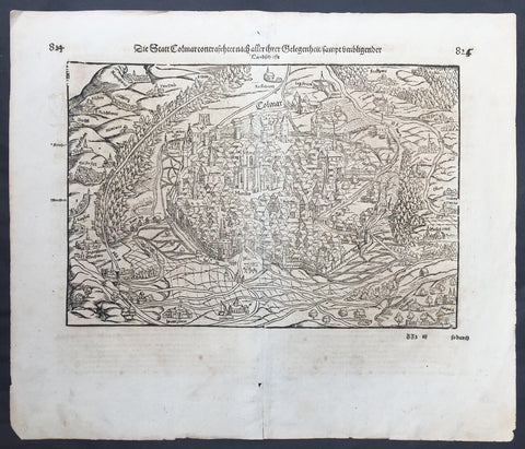
1628 Munster Large Antique Print View of The City of Colmar, Alsace, France
- Title : Die Statt Colmar
- Ref #: 33571
- Size: 17in x 15in (435mm x 380mm)
- Date : 1628
- Condition: (A+) Fine Condition
Description:
This finely engraved original antique print* a view of the French city of city of Colmar, in the Alsace region in north-eastern France was published in the 1628 last release of Sebastian Munsters Cosmographia published by Sebastian Petri, Basle.
Sebastian Petri re-release of Cosomgraphia in 1588 produced some fine woodcut maps in the "copperplate style". The maps in this release were more sophisticated than with earlier publications of Cosomgraphia and were based on the 1570 release of Abraham Ortelius monumental work Theatrum Orbis Terrarum.
Background: For a variety of reasons town plans were comparatively latecomers in the long history of cartography. Few cities in Europe in the middle ages had more than 20,00 inhabitants and even London in the late Elizabethan period had only 100-150,000 people which in itself was probably 10 times that of any other English city. The Nuremberg Chronicle in 1493 included one of the first town views of Jerusalem, thereafter, for most of the sixteenth century, German cartographers led the way in producing town plans in a modern sense. In 1544 Sebastian Munster issued in Basle his Cosmographia containing roughly sixty-six plans and views, some in the plan form, but many in the old panorama or birds eye view. (Ref: Tooley; M&B)
General Description:
Paper thickness and quality: - Light and stable
Paper color: - White
Age of map color: -
Colors used: -
General color appearance: -
Paper size: - 17in x 15in (435mm x 380mm)
Margins: - Min ½in (12mm)
Imperfections:
Margins: - Light age toning
Plate area: - Light age toning
Verso: - Light age toning
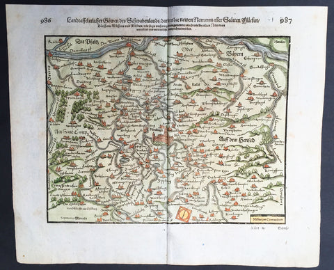
1628 Seb. Munster Antique Map of Swabia, Bavaria, Germany - Danube, Nordlingen
- Title : Landtaffel Etlicher Boewen des Swabenlands...
- Ref #: 33586
- Size: 21in x 13 1/2in (530mm x 340mm)
- Date : 1628
- Condition: (A+) Fine Condition
Description:
This finely engraved hand coloured original antique map of part of German Swaben in Southern Bavaria - centering on the city of Nordlingen stretching to the Danube River - was published in the 1628 last release of Sebastian Munsters Cosmographia published by Sebastian Petri, Basle.
Background:
Swabia - Schwabenland - is a cultural, historic and linguistic region in south-western Germany. The name is ultimately derived from the medieval Duchy of Swabia, one of the German stem duchies, representing the territory of Alemannia, whose inhabitants interchangeably were called Alemanni or Suebi.
This territory would include all of the Alemannic German area, but the modern concept of Swabia is more restricted, due to the collapse of the duchy of Swabia in the thirteenth century. Swabia as understood in modern ethnography roughly coincides with the Swabian Circle of the Holy Roman Empire as it stood during the Early Modern period, now divided between the states of Bavaria and Baden-Württemberg.
Nördlingen is a town in the Donau-Ries district, in Swabia, Bavaria, Germany, It was first mentioned in recorded history in 898, and in 1998 the town celebrated its 1100th anniversary. The town was the location of two battles during the Thirty Years' War, which took place between 1618–1648.
The remains of a Roman castellum, built in the 85AD and probably called Septemiacum, have been found under the city. In 1998, Nördlingen celebrated its 1100-year-old history.
Nördlingen was one of Germany's major trading towns, until its importance declined with the battles of the Thirty Years' War. In 1215 Emperor Frederick II declared Nördlingen aFree Imp erial City, and it remained so until 1802 when it changed to become part of present-day Bavaria. The Nördlingen trade fair (Pfingstmesse) was first mentioned in 1219.
A well-documented legal case of 1471 involved the prostitute Els von Eystett who worked in Nördlingen's Frauenhaus, an officially sanctioned municipal brothel.
Nördlingen was one of the first Protestant cities and took part in the Protestation at Speyer in 1529.
Sebastian Petri re-release of Cosomgraphia in 1588 produced some fine woodcut maps in the "copperplate style". The maps in this release were more sophisticated than with earlier publications of Cosomgraphia and were based on the 1570 release of Abraham Ortelius monumental work Theatrum Orbis Terrarum.
For a variety of reasons town plans were comparatively latecomers in the long history of cartography. Few cities in Europe in the middle ages had more than 20,00 inhabitants and even London in the late Elizabethan period had only 100-150,000 people which in itself was probably 10 times that of any other English city. The Nuremberg Chronicle in 1493 included one of the first town views of Jerusalem, thereafter, for most of the sixteenth century, German cartographers led the way in producing town plans in a modern sense. In 1544 Sebastian Munster issued in Basle his Cosmographia containing roughly sixty-six plans and views, some in the plan form, but many in the old panorama or birds eye view. (Ref: Tooley; M&B)
General Description:
Paper thickness and quality: - Light and stable
Paper color: - White
Age of map color: - Early
Colors used: - Blue, green, orange
General color appearance: - Authentic
Paper size: - 17in x 15in (435mm x 380mm)
Margins: - Min ½in (12mm)
Imperfections:
Margins: - None
Plate area: - None
Verso: - None
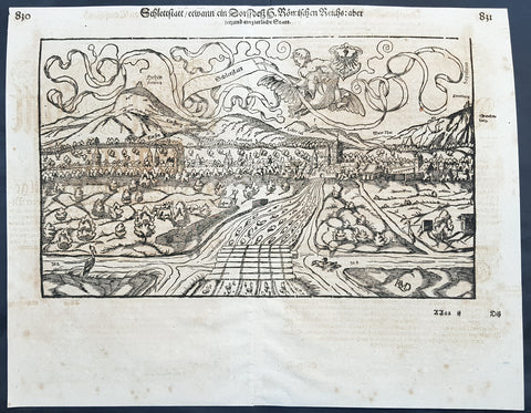
1628 Sebastian Munster & RMD Antique Map Selestat or Schlettstadt Alsace, France
- Title : Die Statt Schletstatt...RMD
- Ref #: 33572
- Size: 15in x 12in (380mm x 305mm)
- Date : 1598
- Condition: (B) Good Condition
Description:
This fine original wood block engraved antique map a birds eye view of the French town of Selestat, formally Schlettstadt under German rule, in the Bas-Rhin in the Grand Est region was engraved by Hans Rudolf Manuel Deutsch (RMD) and published in the German Section of Sebastian Munsters 1628 edition of Cosmographia, Das ist: Beschreibung der gantzen Welt, Darinnen Aller Monarchien Keyserthumben, Königreichen, Fürstenthumben, Graff- und Herrschafften, Länderen, Stätten und Gemeinden.Ursprung (Cosmographia, that is: description of the whole world, in it all monarchies Keyser thumben, kingdoms, prince thumben, graff and herrschafften, countries, places and municipalities.)
Hans Rudolf Manuel Deutsch (1525–1571) was a Swiss artist. He made several of the woodcuts for De re metallica (the metals and mining treatise by Georgius Agricola, the father of mineralogy) and for Sebastian Münsters Cosmographia.
Deutschs father, Niklaus Manuel Deutsch (the Elder), and Deutsch\'s brother, Niklaus Manuel Deutsch the Younger, were also artists. The elder Niklaus had taken the last name Manuel, but all three also commonly used Deutsch as part of their names and signed their paintings with initials ending in D.
Sélestat, German Schlettstadt , is a town in the department of Bas-Rhin in the Grand Est region (until the end of 2015 Alsace ) about 40 km southwest of Strasbourg and about 40 km northwest of Freiburg located in Breisgau on the Ill . The city is the seat of the sub-prefecture of the Arrondissement Sélestat-Erstein.
While Strasbourg is known for having erected the first whole Christmas tree on a public square in the city for the whole of the Advent season, Sélestat is considered the birthplace of the Christmas tree. An entry in a Humanist Library accounting book dates from 1521: Item IIII shill pay the forester meyen to sanct Thomas day (4 shillings to pay for the forester to guard the trees from St. Thomas\'s Day) ). Although this entry documents for the first time the passage between decorated hanging pine branches and the whole Christmas tree in private homes, it does not quite prove that Sélestat introduced this custom. This new practice probably originated in the more global context of opposition between the established Catholic Church and the 16th-century Lutherans in the Lower Alsace area between Strasbourg and Schlettstadt. In addition, the imperial city flourished in many areas in this century and its population was certainly susceptible to social-religious innovations.
It is documented in many places in Alsace that arrangements and wall or door decorations made of evergreen plants were considered by the Catholic Church extremely bad, since they were known to be introduced by the Protestants. In particular, Johann Geiler von Kaysersberg , preacher of the Strasbourg Cathedral denounced these customs, because he feared the return of pagan customs. In Alsace, people traditionally celebrated the feast of St. Nicholas and therefore organized Nicholas markets. As in the other Protestant imperial territories, the Lutherans also wanted to celebrate Christmas in Alsace: at first a whole fir was hanging from the ceiling of the room, then it was placed in a bucket full of sand. The village chaplains were to reveal abuses in the stately forests nine days before and nine after Christmas. By the end of the 16th century, whole firs were first in the Alsatian guild houses, then relatively early in all more or less noble family houses.
Vauban built new fortifications and the city became the site of a French garrison. It regained some prosperity, but its growth remained low compared to other Alsatian cities. With the administrative reforms of the French Revolution, Schlettstadt became part of the Bas-Rhin département .
During the affiliation of the city to the German Empire (1871-1918), the city was the seat of the district Schlettstadt in the district Unterelsaß . 1876/80, the King Karl barracks was built here. In 1914, the Rheinische Jäger Battalion No. 8 was stationed there. Between 1918 and 1940 she was occupied as Caserne Schweisguth by the French army.
General Definitions:
Paper thickness and quality: - Heavy and stable
Paper color : - off white
Age of map color: -
Colors used: -
General color appearance: -
Paper size: - 15in x 12in (380mm x 305mm)
Plate size: - 15in x 12in (380mm x 305mm)
Margins: - Min 1/2in (10mm)
Imperfections:
Margins: - Light offsetting, margins cropped
Plate area: - Light offsetting
Verso: - Offsetting
ackground:
Cosmographia, Das ist: Beschreibung der gantzen Welt, Darinnen Aller Monarchien Keyserthumben, Königreichen, Fürstenthumben, Graff- und Herrschafften, Länderen, Stätten und Gemeinden.Ursprung, Regiment, Reichthumb, Gewalt und.Beschaffenheit. Dessgleichen Aller deren, beyder Ständen, Regenten: Keysern, Königen, Bäpsten, Bischoffen.Genealogien und Stammbäumen.zusammen getragen. by Sebastian Münster was first published in 1544 and is the earliest German-language description of the world. It had numerous editions in different languages including Latin, French (translated by François de Belleforest), Italian, English, and Czech. The last German edition was published in 1628, long after Munsters death. The Cosmographia was one of the most successful and popular books of the 16th century. It passed through 24 editions in 100 years. This success was due to the notable woodcuts (some by Hans Holbein the Younger, Urs Graf, Hans Rudolph Manuel Deutsch, and David Kandel). It was most important in reviving geography in 16th-century Europe. Among the notable maps within Cosmographia is the map Tabula novarum insularum, which is credited as the first map to show the American continents as geographically discrete.
Munsters earlier geographic works were Germania descriptio (1530) and Mappa Europae (1536). In 1540, he published a Latin edition of Ptolemys Geographia with illustrations.
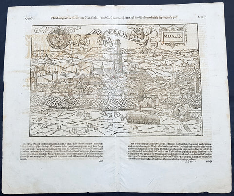
1628 Sebastian Munster & RMD Antique Map View Nordlingen Swabia, Bavaria Germany
- Title : Die Statt Nordlingen
- Ref #: 33587
- Size: 17in x 15in (435mm x 380mm)
- Date : 1628
- Condition: (A+) Fine Condition
Description:
This fine original wood block engraved antique map a birds eye view of the German town of Nördlingen in the Donau-Ries district, in Swabia, Bavaria,, was engraved by Hans Rudolf Manuel Deutsch (RMD) in 1549 - dated - and published in the German Section of Sebastian Munsters 1628 edition of Cosmographia, Das ist: Beschreibung der gantzen Welt, Darinnen Aller Monarchien Keyserthumben, Königreichen, Fürstenthumben, Graff- und Herrschafften, Länderen, Stätten und Gemeinden.Ursprung (Cosmographia, that is: description of the whole world, in it all monarchies Keyser thumben, kingdoms, prince thumben, graff and herrschafften, countries, places and municipalities.)
Hans Rudolf Manuel Deutsch (1525–1571) was a Swiss artist. He made several of the woodcuts for De re metallica (the metals and mining treatise by Georgius Agricola, the father of mineralogy) and for Sebastian Münsters Cosmographia.
Deutschs father, Niklaus Manuel Deutsch (the Elder), and Deutsch\'s brother, Niklaus Manuel Deutsch the Younger, were also artists. The elder Niklaus had taken the last name Manuel, but all three also commonly used Deutsch as part of their names and signed their paintings with initials ending in D.
Nördlingen is a town in the Donau-Ries district, in Swabia, Bavaria, Germany. The town was the location of two battles during the Thirty Years\' War, which took place between 1618–1648. Today it is one of only three towns in Germany that still has a completely established city wall, the other two being Rothenburg ob der Tauber and Dinkelsbühl.
General Definitions:
Paper thickness and quality: - Heavy and stable
Paper color : - off white
Age of map color: -
Colors used: -
General color appearance: -
Paper size: - 17in x 15in (435mm x 380mm)
Plate size: - 17in x 15in (435mm x 380mm)
Margins: - Min 1/2in (10mm)
Imperfections:
Margins: - Light offsetting
Plate area: - Light offsetting
Verso: - Light offsetting
Background:
Cosmographia, Das ist: Beschreibung der gantzen Welt, Darinnen Aller Monarchien Keyserthumben, Königreichen, Fürstenthumben, Graff- und Herrschafften, Länderen, Stätten und Gemeinden.Ursprung, Regiment, Reichthumb, Gewalt und.Beschaffenheit. Dessgleichen Aller deren, beyder Ständen, Regenten: Keysern, Königen, Bäpsten, Bischoffen.Genealogien und Stammbäumen.zusammen getragen. by Sebastian Münster was first published in 1544 and is the earliest German-language description of the world. It had numerous editions in different languages including Latin, French (translated by François de Belleforest), Italian, English, and Czech. The last German edition was published in 1628, long after Munsters death. The Cosmographia was one of the most successful and popular books of the 16th century. It passed through 24 editions in 100 years. This success was due to the notable woodcuts (some by Hans Holbein the Younger, Urs Graf, Hans Rudolph Manuel Deutsch, and David Kandel). It was most important in reviving geography in 16th-century Europe. Among the notable maps within Cosmographia is the map Tabula novarum insularum, which is credited as the first map to show the American continents as geographically discrete.
Munsters earlier geographic works were Germania descriptio (1530) and Mappa Europae (1536). In 1540, he published a Latin edition of Ptolemys Geographia with illustrations.
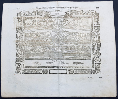
1628 Sebastian Munster Antique Map Birds Eye View of the city of Lyon, France
- Title : Die Statt Leon
- Ref #: 33547
- Size: 17in x 15in (435mm x 380mm)
- Date : 1628
- Condition: (A+) Fine Condition
Description:
This fine original wood block engraved antique map a birds eye view of the French city of Lyon in the Auvergne-Rhône-Alpes region was published in the French Section of Sebastian Munsters 1628 edition of Cosmographia, Das ist: Beschreibung der gantzen Welt, Darinnen Aller Monarchien Keyserthumben, Königreichen, Fürstenthumben, Graff- und Herrschafften, Länderen, Stätten und Gemeinden.Ursprung (Cosmographia, that is: description of the whole world, in it all monarchies Keyser thumben, kingdoms, prince thumben, graff and herrschafften, countries, places and municipalities.)
Lyon is the third-largest city and second-largest urban area of France. It is located in the country\'s east-central part at the confluence of the rivers Rhône and Saône, about 470 km south from Paris, 320 km north from Marseille and 56 km northeast from Saint-Étienne.
Fernand Braudel remarked, Historians of Lyon are not sufficiently aware of the bi-polarity between Paris and Lyon, which is a constant structure in French development...from the late Middle Ages to the Industrial Revolution. In the late 15th century, the fairs introduced by Italian merchants made Lyon the economic counting house of France. Even the Bourse (treasury), built in 1749, resembled a public bazaar where accounts were settled in the open air. When international banking moved to Genoa, then Amsterdam, Lyon remained the banking centre of France.
During the Renaissance, the citys development was driven by the silk trade, which strengthened its ties to Italy. Italian influence on Lyon\'s architecture is still visible among historic buildings. In the later 1400s and 1500s Lyon was also a key centre of literary activity and book publishing, both of French writers (such as Maurice Scève, Antoine Heroet, and Louise Labé) and of Italians in exile (such as Luigi Alamanni and Gian Giorgio Trissino).
In 1572, Lyon was a scene of mass violence by Catholics against Protestant Huguenots in the St. Bartholomews Day Massacre. Two centuries later, Lyon was again convulsed by violence when, during the French Revolution, the citizenry rose up against the National Convention and supported the Girondins. The city was besieged by Revolutionary armies for over two months before surrendering in October 1793. Many buildings were destroyed, especially around the Place Bellecour, while Jean-Marie Collot d Herbois and Joseph Fouché administered the execution of more than 2,000 people. The Convention ordered that its name be changed to Liberated City and a plaque was erected that proclaimed Lyons made war on Liberty; Lyons no longer exists. A decade later, Napoleon ordered the reconstruction of all the buildings demolished during this period.
The city became an important industrial town during the 19th century. In 1831 and 1834, the canuts (silk workers) of Lyon staged two major uprisings for better working conditions and pay. In 1862, the first of Lyons extensive network of funicular railways began operation.
General Definitions:
Paper thickness and quality: - Heavy and stable
Paper color : - off white
Age of map color: -
Colors used: -
General color appearance: -
Paper size: - 17in x 15in (435mm x 380mm)
Plate size: - 17in x 15in (435mm x 380mm)
Margins: - Min 1/2in (10mm)
Imperfections:
Margins: - None
Plate area: - None
Verso: - None
Background:
Cosmographia, Das ist: Beschreibung der gantzen Welt, Darinnen Aller Monarchien Keyserthumben, Königreichen, Fürstenthumben, Graff- und Herrschafften, Länderen, Stätten und Gemeinden.Ursprung, Regiment, Reichthumb, Gewalt und.Beschaffenheit. Dessgleichen Aller deren, beyder Ständen, Regenten: Keysern, Königen, Bäpsten, Bischoffen.Genealogien und Stammbäumen.zusammen getragen. by Sebastian Münster was first published in 1544 and is the earliest German-language description of the world. It had numerous editions in different languages including Latin, French (translated by François de Belleforest), Italian, English, and Czech. The last German edition was published in 1628, long after Munsters death. The Cosmographia was one of the most successful and popular books of the 16th century. It passed through 24 editions in 100 years. This success was due to the notable woodcuts (some by Hans Holbein the Younger, Urs Graf, Hans Rudolph Manuel Deutsch, and David Kandel). It was most important in reviving geography in 16th-century Europe. Among the notable maps within Cosmographia is the map Tabula novarum insularum, which is credited as the first map to show the American continents as geographically discrete.
Munsters earlier geographic works were Germania descriptio (1530) and Mappa Europae (1536). In 1540, he published a Latin edition of Ptolemys Geographia with illustrations.
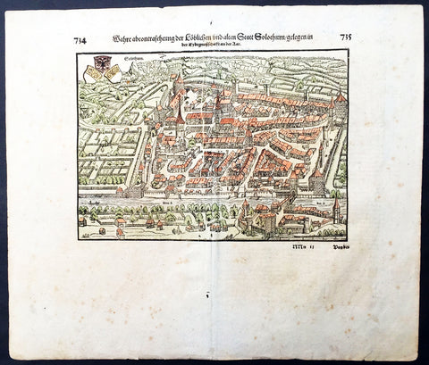
1628 Sebastian Munster Old, Antique Print View of City of Solothurn, Switzerland
- Title : Die Statt Solothurn
- Ref #: 33566
- Size: 17in x 15in (435mm x 380mm)
- Date : 1628
- Condition: (A+) Fine Condition
Description:
This finely engraved hand coloured original antique print* a view of the Swiss City of Solothurn was published in the last 1628 release of Sebastian Munsters Cosmographia published by Sebastian Petri, Basle.
Background: During the Early Middle Ages, Solothurn was part of the Kingdom of Lotharingia (Lorraine). After the collapse of Lotharingia, it became part of the Second Kingdom of Burgundy. In 1033, the Kingdom of Burgundy became part of the Holy Roman Empire and Solothurn gained some independence. In 1038, Emperor Conrad II held court at Solothurn and there crowned his son, Henry III King of Burgundy. The royal court resided in Solothurn on several occasions until 1052, however, there is no evidence of a permanent royal palace. In 1127, it was acquired by the dukes of Zähringen. Under the rule of the Zähringens, in 1146, Solothurn's coins are first mentioned. In 1182, causidicus or Zähringen appointed judges first appeared in Solothurn. After the extinction of the Zähringer line in 1218 it became a free imperial city under the Holy Roman Emperor. In 1252, the town council andSchultheiss or mayor became mostly independent and had their own town seals. In 1251 it was mentioned as saluerre and in 1275 as Solotren. Starting around 1200, there was a council of nobles in the town.
In 1252, a group of nobles that could witness and support deeds, known as consuls et cives Solodorenses, first appears in the town. Initially the nobles exercised power over the entire town. However, the guild movement of the 14th Century resulted in a reduction in the power of the nobles and also a restricted guild system in Solothurn. By around 1350, an eleven-member Altrat (Council of Elders) and a 22-member Jungrat (Younger Council) existed in the city. Each of the eleven guilds were represented by a member of the Altrat and two members of the Jungrat. These 33 councillors exercised, together with the mayor, the power of government and helped appoint law makers. The members of the two councils were elected each year by the citizens of the city, after which the councils and mayor appointed many of the government officials. The noble families retained some power as the guilds became part of the town council. However, in 1459 the last noble family died out and positions on the council fell to wealthy farmers, butchers and millers.
Until the pogrom on 1348 during an outbreak of the plague, there was a small Jewish community in Solothurn.
Over the 13th to 15th centuries, the citizens of the city slowly emancipated themselves from the higher nobility. In 1276 and 1280 Emperor Rudolf I codified the previously poorly defined rights of the city and granted it the privilege de non Evocando or the right that their citizens were protected from trial in foreign courts. In 1344 Solothurn acquired the right to appoint their own Schultheiss from the Count of Buchegg, which was confirmed by Emperor Charles IV in 1360. In 1409, Emperor Ruprecht extended the de non Evocando privilege to include the royal High Court as well.
As the city grew in power, it bound the Monastery of St. Ursus more closely to the city. In 1251 the city defeated claims made by the Monastery on the right to appoint the Schultheiss. Shortly after the acquisition of the right to the Schultheiss office in 1344, the city came into possession of the vogt right over the Monastery by granting citizenship rights to the former vogt (bailiff), Burkhard Senn the Elder. In 1512-20 the city received the right to appoint canons and provosts from the Pope.
After the alliance with Bern in 1295, it became part of the Swiss Confederation. In 1382 the Habsburgs attacked the city, involving Solothurn in the Battle of Sempach. By the treaty of two years later, the Habsburgs renounced all claims to the territory of the city. The latter was expanded by acquisition of neighbouring lands in the 15th century, roughly up to the today's canton area.
In 1481, it obtained full membership in the Swiss Confederation. From 1530 to 1792 it was the seat of the French ambassador to Switzerland.
Sebastian Petri re-release of Cosomgraphia in 1588 produced some fine woodcut maps in the "copperplate style". The maps in this release were more sophisticated than with earlier publications of Cosomgraphia and were based on the 1570 release of Abraham Ortelius monumental work Theatrum Orbis Terrarum.
For a variety of reasons town plans were comparatively latecomers in the long history of cartography. Few cities in Europe in the middle ages had more than 20,00 inhabitants and even London in the late Elizabethan period had only 100-150,000 people which in itself was probably 10 times that of any other English city. The Nuremberg Chronicle in 1493 included one of the first town views of Jerusalem, thereafter, for most of the sixteenth century, German cartographers led the way in producing town plans in a modern sense. In 1544 Sebastian Munster issued in Basle his Cosmographia containing roughly sixty-six plans and views, some in the plan form, but many in the old panorama or birds eye view. (Ref: Tooley; M&B)
General Description:
Paper thickness and quality: - Light and stable
Paper color: - White
Age of map color: - Early
Colors used: - Blue, green, red, brown
General color appearance: - Authentic
Paper size: - 17in x 15in (435mm x 380mm)
Margins: - Min ½in (12mm)
Imperfections:
Margins: - Light age toning
Plate area: - Light age toning
Verso: - Light age toning
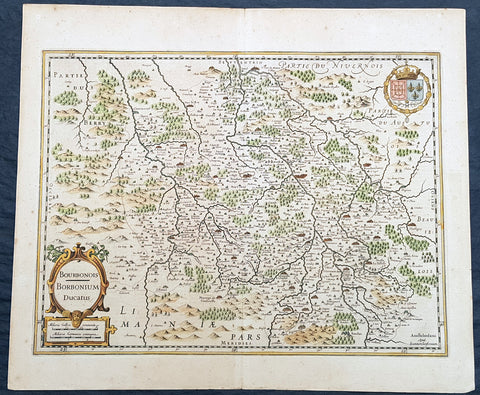
1629 Jan Jansson Antique Map of The Bourbon or Bourbonnais Region Central France
- Title : Boubonoius; Borbonium Ducatus
- Ref #: 50238
- Size: 21 1/2in x 17 1/2in (490mm x 340mm)
- Date : 1629
- Condition: (A+) Fine Condition
Description:
This beautifully hand coloured original copper-plate engraved antique map of The Bourbon or Bourbonnais Region of central France was published in the rare 1629 Latin edition of Mercators Atlas by Jan Jansson and Henricus Hondius.
General Definitions:
Paper thickness and quality: - Heavy and stable
Paper color : - off white
Age of map color: - Original
Colors used: - Yellow, green, blue, pink
General color appearance: - Authentic
Paper size: - 21 1/2in x 17 1/2in (490mm x 340mm)
Plate size: - 20in x 15in (510mm x 380mm)
Margins: - Min 1in (25mm)
Imperfections:
Margins: - Uniform age toning
Plate area: - Uniform age toning
Verso: - Uniform age toning
Background:
Bourbonnais was a historic province in the centre of France that corresponded to the modern département of Allier, along with part of the département of Cher. Its capital was Moulins.
The title of the ruler of Bourbonnais between 913 and 1327, was Sire de Bourbon (or Seigneur de Bourbon). The first lord of Bourbonnais known by name was Adhémar (or Aymon I of Bourbon). Aymon\'s father was Aymar (894-953), sire of Souvigny, his only son with Ermengarde.Aymar lived during the reign of Charles the Simple who, in 913, gave him fiefs on the Allier River in which would become Bourbonnais. He acquired the castle of Bourbon (today Bourbon-l\'Archambault). Almost all early lords took the name d\'Archambaud, after the palace, but later the family became known as the \"House of Bourbon\".
The first House of Bourbon ended in 1196, with the death of Archambault VII, who had only one heir, Mathilde of Bourbon. She married Guy II of Dampierre, who added Montlucon to the possessions of the lords of Bourbon. The second house of Bourbon started in 1218, with Archambault VIII, son of Guy II and Mahaut, and brother of William II of Dampierre. He was followed by his son Archambaut IX, who died in Cyprus in 1249, during a crusade. The House of Burgundy then acquired Bourbonnais.
In 1272, Beatrice of Burgundy (1258-1310), Lady of Bourbon, married Robert de France (1256-1318), Count of Clermont, son of king Louis IX (Saint-Louis). Thus began the long-lasting House of Bourbon, which would provide the kings of France from Henry IV to Louis-Phillipe in 1848, when France abolished its monarchy.
The Bourbons had concluded an alliance with the royal power. They put their forces at the service of the king, thus benefitting from the geographic position of Bourbonnais, located between the royal fidemesne and the duchies of Aquitaine and Auvergne. This alliance, as well as the marriage of Béatrix de Bourgogne and Robert de France, aided the rise and prosperity of the province. In 1327, King Charles (le Bel) elevated Boubonnais to the status of a duchy. (Ref: Koeman; M&B; Tooley)
1629 Willem Blaeu Antique Map of the Holy Land Palestine Jerusalem Twleve Tribes
- Title : Terra Sancta quae in Sacris Terra Promissionis olim Palestina....Guiljesmi Blaeuw 1629
- Date : 1629
- Condition: (A+) Fine Condition
- Ref: 93509
- Size: 23 1/2in x 20in (590mm x 495mm)
Description:
This magnificent original copper plate engraved antique map of the Holy Land, Terra Sancta, Palestine was one of the very few dated maps printed by Willem Blaeu. The map was engraved by Jodocus Hondius the younger and published by Willem Blaeu in the 1643 French edition of Atlas Novus.
General Definitions:
Paper thickness and quality: - Heavy and stable
Paper color : - off white
Age of map color: - Original
Colors used: - Blue, pink, red, green, yellow
General color appearance: - Authentic
Paper size: - 23 1/2in x 20in (590mm x 495mm)
Plate size: - 20in x 15 1/4in (505mm x 384mm)
Margins: - Min 1in (25mm)
Imperfections:
Margins: - None
Plate area: - None
Verso: - None
Background:
This is one of the very few maps published in Blaeus Atlas that bears a date. It was actually made by Jodocus Hondius the younger in 1629, but was not printed until after the plate was purchased by Willem Blaeu (who added his imprint in the lower part of the cartouche)
At this time, many of the maps of Palestine were oriented to show the east at the top to focus on Jerusalem. Here, the orientation is inverted so that Blaeus map shows Palestine as it might have been viewed by Moses from the top of Mt Pisgah. The decorative features are Old Testament in inspiration: Moses holding the Tablets of the Law, stands to the left of the cartouche, Aaron to the right, while in the Mediterranean Jonah is about to be swallowed by the whale and in the Sinai is shown the route of the Exodus. In the Red Sea at Yam Suf, Pharaohs armies are shown drowning. The lands of the Twelve Tribes are shown straddling both banks of the Jordan and the city of Jerusalem can be seen occupying a place of honour in the upper centre of the map.
The geographical detail of the map is taken from an large inset on a large map of Palestine by the traveller Pieter Laicksteen and the mapmaker to Phillip II of Spain, Christian s Grooten, published at Antwerp in 1570. This inset map, its importance recognised by Hondius and by Blaeu, was unorthodox in its treatment of the outline of the Red Sea and its triangular outline for the Sinai peninsula - lone before either was finally admitted by mapmakers as more accurate than traditionally accepted versions.
The Blaeus retained this map for all editions of the firms atlas for more than thirty years from 1630, even though the rival publisher Johannes Jansson issued a more detailed seven sheet map of the region in his own atlas.
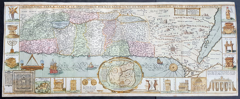
1630 Jacob Tirinus Large Early Antique 1st Edition Map of The Holy Land, Palestine, Israel
- Title : Chorographia Terrae Sanctae in angustiorem Formam Redacta, et ex variis auctoribus a multis errorbus expurgata
- Ref #: 82082
- Size: 33 3/4in x 13 3/4in (855mm x 350mm)
- Date : 1632
- Condition: (A) Very Good Condition
Description:
This large magnificent, hand coloured original copper plate engraved antique 1st edition map of the Holy Land by Johann Belling & Augustus Vindel was published in the 1632 edition of Commentarius in Sacram Scripturam (Commentary on the New and Old Testament) by the Belgian Jesuit monk Jacobus Tirinus.
This is without doubt one of the most visually stunning maps of the Holy land ever published and there have been many elaborated & beautiful maps of this important region published since the dark ages, when the Holy Land was considered the geographical center of the world.
This map was originally prepared in 1632 for Tirinuss study of the Holy Land and was originally engraved by Cornelius Galle and printed in Antwerp by Martinus Nutius. Tirinuss work went through many editions and printings
Background: Oriented to the East the map is surrounded with panels of vignettes displaying sacred objects including a menorah, the arc of the covenant, the altar of sacrifices, the Tabernacle, and a plan and elevations of the Temple. At center is an inset bird's-eye plan of ancient Jerusalem based on the Spanish biblical geographer, Juan Bautista Vilalpando. Oriented with east at top, the map includes the territories of the twelve tribes on both sides of the Jordan River and the route of the Exodus and Wandering. The map depicts from Syria and Tyre southward as far as the Sinai, Egypt and Thebes. At the southern most point, in Egypt, is located the city of Thebes and, slightly to the north, near Memphis, the wildly misshapen Pyramids of Egypt. Slightly further north is the city of Tanis, possible resting place for the Ark of the Covenant. In this spirit, slightly to the south of Tanis, the city of Ramesse is indicated as the starting point of the Biblical Exodus and the wandering of the Hebrews. Following their path into the desert and across the Red Sea – where Pharaoh is shown being inundated by the returning waters following Moses’ parting of the Red Sea. Now in the Sinai, we can follow the footsteps of the Hebrews to Mount Sinai (Sinai Mons), where Moses is drawn throwing down the tablets of God. Slightly to the northwest of this location a cleft in the mountains reveals the location of the ancient Nabatean city of Petra. With regard to Petra, the location and gorge detail is surprisingly accurate considering that it was only “discovered” by the Swiss adventurer Johannes L. Burckhardt, in 1812, 200 years after this map was drawn. Heading northward the lands claimed by the various tribes of Israel are beautifully detailed along with major cities, camps, roads, and trade routes. The Mediterranean is decorated with sailing ships and, in the lower left quadrant, a surveying tool between two censors. Surrounding the map proper on the left, right, and bottom margins, there are 19 maps and images of Biblical objects. The largest and most central of these is a stunning inset of Jerusalem, which notes the various temples and important buildings located there. Other images include the Arc of the Covenant, Israelite coins, Roman antiquities, views of a Menorah, various angels, and a plan of the Temple. All in all an extraordinary piece, one of the most attractive maps of the Holy Land ever made.
Jacobus Tirinus (1580 - 1636) or Jacobi Tirini was a Jesuit monk, theologian, historian, and Biblical scholar. His major work is the Commentarius in Sacram Scripturam a two volume Bible commentary. Tirini was born in Antwerp, Belgium in 1580. Following his admission into the Jesuit Order, Tirini became a respected Biblical scholar and a prominent member of the Order. He was assigned First Superior to the Antwerp Jesuit House as well as "Directior of the Holland Mission". Tirini's Biblial commentaries are still referenced today.(Ref: Laor; M&B; Tooley)
General Description:
Paper thickness and quality: - Heavy & stable
Paper color: - White
Age of map color: - Early
Colors used: - Green, blue, yellow, red, orange
General color appearance: - Authentic
Paper size: - 33 3/4in x 13 3/4in (855mm x 350mm)
Plate size: - 33in x 13in (840mm x 330mm)
Margins: - Min 1/2in (15mm)
Imperfections:
Margins: - Top margin extended from plate-mark
Plate area: - Very light creasing in folds.
Verso: - Light soiling
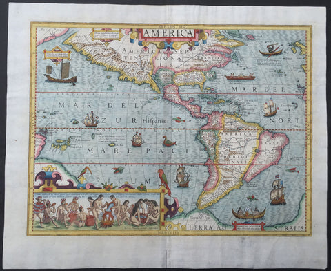
1630 Jodocus Hondius Antique Map of America
- Title : America
- Ref #: 61032
- Size: 22 1/4in x 18 1/4in (565mm x 465mm)
- Date : 1630
- Condition: (A+) Fine Condition
Description:
This magnificent and extremely important, hand coloured original antique map of America was drawn and engraved by Jodocus Hondius for inclusion in his editions of Gerard Mercator's Atlas sive Cosmographicae between 1606 and 1630. This actual map is from the last 1630 Latin edition, identified by the text line Mmmmmmmm on the verso of the map.
This map like many of the time was published on a stereographic projection and is an amalgam of various sources. It incorporates a more correct west coast of South America and narrows still further the longitudinal width of New Spain at the Tropic of Cancer, making it just 10°, much closer in reality. However, like all cartography before, it still retains an enlarged North American continent.
A Plancius type depiction of Newfoundland occurs alongside a typical representation of the east coast, with a more protruding Virginia than usual. Various scenes taken from earlier volumes of de Bry's Grand Voyages adorn the whole. Particularly notable is the native Brazilian scene illustrating the method used to make the local beverage, derived from Hans Stadens voyage as recorded by de Bry.
There are various galleons, kayaks and Indian canoes along with a pair of birds perched on the inset.
Background: This map was engraved by Jodocus Hondius for his first edition of Gerard Mercator's atlas. Intended to be a grand comprehensive work, with the first part originally appearing in 1585, by Mercator's death in 1594 only two parts had been published. Continued by his family, it was still incomplete for the 1602 edition, lacking most importantly a section on the Iberian peninsula. During this time it was also competing with the remarkably successful atlas of Abraham Ortelius which averaged almost one edition per year. By 1604 Jodocus Hondius was flourishing, and in that year acquired all of the plates from Mercator's descendant. He immediately set about engraving many new maps to augment and complete the work, amongst which was a set of the four continents. He also had the original text expanded by Petrus Montanus. In the following year he brought out Mercator's Ptolemy, and in 1606 his first edition of the general atlas which proved instantly popular, selling out within a year.
Right up until 1630 this attractive map was issued alongside the AMERICA sive INDIA NOVA by Michael Mercator, 1595. Since the text describing America was always used by the Mercator, this one is always lacking one. Produced on a stereographic projection like more and more maps of the time, it is an amalgam of various sources. (Ref: Burden; Koeman; M&B; Tooley)
Condition Report
Paper thickness and quality: - Heavy and stable
Paper color: - White
Age of map color: - Original & later
Colors used: - Red, yellow, green
General color appearance: - Authentic
Paper size: - 22 1/4in x 18 1/4in (565mm x 465mm)
Plate size: - 19 3/4in x 14 3/4in (500mm x 375mm)
Margins: - Min 1in (25mm)
Imperfections:
Margins: - Professional repair to bottom center-fold and bottom left margin 1 1/2in into image, no loss
Plate area: - None
Verso: - Light age toning

1630-31 Hondius Antique World & Four Continent Maps America Africa Asia & Europe
- Title : Nova Totius Terrarum; America Noviter Delineata; Africae Nova Tabula; Asia recens summa; Europa Exactissime.
- Date : 1630-31
- Size: 22 1/2in x 20in (520mm x 505mm) ea
- Condition: (A & A+) Very Good & Fine Condition
- Ref: 43164; 43157; 43158; 43160; 43159
Description:
These 5 original, hand coloured copper plate engraved world and 4 continental maps, engraved by Henricus Hondius between 1630 and 1631 were published in the same 1639 edition of the Hondius/Mercator Atlas.
Henricus Hondius' World and Four Continent Maps are a series of highly detailed and beautifully illustrated and hand coloured maps that represent some of the finest examples of 17th-century cartography & artistry. The world map features ornate illustrations of ships, sea monsters, and mythological creatures, as well as depictions of important cities and landmarks around the globe. The four continent maps - Europe, Asia, Africa, and the Americas - are similarly detailed and feature intricate illustrations of people, animals, and mythological figures from each region. These maps are notable for their use of the Mercator projection and their accuracy in depicting the size and shape of the continents. Henricus Hondius' maps were highly valued during his lifetime and continue to be prized by collectors and scholars today for their historical significance and artistic beauty.
General Definitions:
Paper thickness and quality: - Heavy and stable
Paper color : - off white
Age of map color: - Original
Colors used: - Yellow, green, blue, pink
General color appearance: - Authentic
Paper size: - Please see background description below
Plate size: - Please see background description below
Margins: - Please see background description below
Imperfections:
Margins: - Please see background description below
Plate area: - Please see background description below
Verso: - Please see background description below
Background:
Nova Totius Terrarum: Dated 1630. Beautiful original hand colour, strong clean paper, original margin size. General Definitions:
Paper thickness and quality: - Heavy and stable
Paper color : - off white
Age of map color: - Original
Colors used: - Yellow, green, blue, pink, red
General color appearance: - Authentic
Paper size: - 22 1/2in x 20in (520mm x 505mm)
Plate size: - 21 1/2in x 15in (545mm x 380mm)
Margins: - Min 1in (25mm)
Imperfections:
Margins: - Old expert re-enforcement of margins front & verso. 4 small wormholes to margins
Plate area: - Creasing, slight separation of centerfold on bottom section of map
Verso: - Centerfold re-enforced
Overall condition: - VG
America Noviter Delineata: Dated 1631. Beautiful original hand colour, strong clean paper, original margins.
General Definitions:
Paper thickness and quality: - Heavy and stable
Paper color : - off white
Age of map color: - Original
Colors used: - Yellow, green, blue, pink, red
General color appearance: - Authentic
Paper size: - 22 1/2in x 20in (520mm x 505mm)
Plate size: - 19 3/4in x 15in (500mm x 380mm)
Margins: - Min 1in (25mm)
Imperfections:
Margins: - Light age toning
Plate area: - Light creasing along centerfold
Verso: - Bottom margin of centerfold re-enforced
Overall condition: - Fine
Africae Nova Tabula: Dated 1631. Beautiful original hand colour, strong clean paper, original margins.
General Definitions:
Paper thickness and quality: - Heavy and stable
Paper color : - off white
Age of map color: - Original
Colors used: - Yellow, green, blue, pink, red
General color appearance: - Authentic
Paper size: - 22 1/2in x 20in (520mm x 505mm)
Plate size: - 19 3/4in x 15in (500mm x 380mm)
Margins: - Min 1in (25mm)
Imperfections:
Margins: - Light age toning
Plate area: - Slight separation to bottom of centerfold
Verso: - Bottom margin of centerfold re-enforced
Overall condition: - Fine
Asia recens summa: Dated 1631. Beautiful original hand colour, strong clean paper, original margins.
General Definitions:
Paper thickness and quality: - Heavy and stable
Paper color : - off white
Age of map color: - Original
Colors used: - Yellow, green, blue, pink, red
General color appearance: - Authentic
Paper size: - 22 1/2in x 20in (520mm x 505mm)
Plate size: - 19 3/4in x 15in (500mm x 380mm)
Margins: - Min 1in (25mm)
Imperfections:
Margins: - Light age toning
Plate area: - Light creasing along centerfold
Verso: - Bottom centerfold & left corner margin re-enforced
Overall condition: - Fine
Europa Exactissime: Dated 1631. Beautiful original hand colour, strong clean paper, original margins.
General Definitions:
Paper thickness and quality: - Heavy and stable
Paper color : - off white
Age of map color: - Original
Colors used: - Yellow, green, blue, pink, red
General color appearance: - Authentic
Paper size: - 22 1/2in x 20in (520mm x 505mm)
Plate size: - 19 3/4in x 15in (500mm x 380mm)
Margins: - Min 1in (25mm)
Imperfections:
Margins: - Light age toning
Plate area: - Light creasing along centerfold
Verso: - Bottom margin re-enforced
Overall condition: - Fine
Please note all items auctioned are genuine, we do not sell reproductions. A Certificate of Authenticity (COA) can be issued on request.
1631 Jansson Old, Antique Map The Rhone Region of France - Lyon
- Title : Lionnois, Forest et Beaviolois
- Ref #: 41649
- Size: 24in x 20in (610mm x 510mm)
- Date : 1631
- Condition: (A+) Fine Condition
Description:
This finely engraved beautifully hand coloured original antique 1st edition map of the Rhône-Alpes region of France - centering on the Rhone River and the cities of Lyon & Macon - was published in the 1631 edition of Mercators Atlas published by Henricus Hondius and Jan Jansson.
Jodocus Hondius (1563 - 1612), one of the most notable engravers of his time, is known for his work in association with many of the cartographers and publishers prominent at the end of the sixteenth and the beginning of the seventeenth century.
In 1604 Hondius bought the plates of Mercator's Atlas which, in spite of its excellence, had not competed successfully with the continuing demand of Abraham Ortelius's Theatrum Orbis Terrarum.
To meet this competition Hondius added about 40 maps to Mercator's original number and from 1606 published enlarged editions in many languages, still under Mercator's name but with his own name as publisher. These atlases have become known as the Mercator/Hondius series. The following year the maps were re-engraved in miniature form and issued as a pocket Atlas Minor.
After the death of Jodocus Hondius the Elder in 1612, work on the two atlases, folio and miniature, was carried on by his widow and sons, Jodocus II and Henricus, and eventually in conjunction with Jan Jansson in Amsterdam. In all, from 1606 onwards, nearly 50 editions with increasing numbers of maps with texts in the main European languages were printed. (Ref: Koeman; M&B; Tooley)
General Description:
Paper thickness and quality: - Heavy and stable
Paper color: - off white
Age of map color: - Early
Colors used: - Green, red, orange, yellow, blue
General color appearance: - Authentic
Paper size: - 24in x 20in (610mm x 510mm)
Plate size: - 20in x 15in (535mm x 385mm)
Margins: - Min 1in (25mm)
Imperfections:
Margins: - Light spotting not affecting the image
Plate area: - Age toning along centerfold
Verso: - None
1632 Henricus David Large Antique Portrait of Cartographer Giovanni A Magini
- Title : Io. Antonius Maginus Pat. Mathemat. In Bonon. Gymn. Profess
- Date : 1632
- Condition: (A+) Fine Condition
- Ref: 92835
- Size: 17 1/2in x 11in (445mm x 280mm)
Description:
This fine beautifully hand coloured original antique portrait of the Italian Cartographer Giovanni Antonio Magini was engraved by Henricus David in 1632 - date is engraved below portrait.
Giovanni Antonio Magini (1555-1617) was an Italian mathematician, cartographer and Professor of Astronomy in Bologna. He is responsible for publishing an edition ofPtolemy's Geographia in 1596 that contained 27 maps of the ancient world drawn from the text of Claude Ptolemy, along with 27 contemporary or modern maps. His maps were used by Blaeu in 1640. (Ref: Tooley; M&B)
General Description:
Paper thickness and quality: - Heavy and stable
Paper color: - off white
Age of map color: - Original
Colors used: - Yellow, green, red, brown.
General color appearance: - Fresh
Paper size: - 17 1/2in x 11in (445mm x 280mm)
Plate size: - 12n x 8 1/2in (305mm x 215mm)
Margins: - Min 1in (25mm)
Imperfections:
Margins: - Light dis-colouration in top margin
Plate area: - None
Verso: - None
1632 Henricus David Large Antique Portrait of Cartographer Giovanni A Magini
- Title : Io. Antonius Maginus Pat. Mathemat. In Bonon. Gymn. Profess
- Date : 1632
- Condition: (A+) Fine Condition
- Ref: 80766
- Size: 17 1/2in x 11in (445mm x 280mm)
Description:
This fine beautifully hand coloured original antique portrait of the Italian Cartographer Giovanni Antonio Magini was engraved by Henricus David in 1632 - date is engraved below portrait.
Giovanni Antonio Magini (1555-1617) was an Italian mathematician, cartographer and Professor of Astronomy in Bologna. He is responsible for publishing an edition ofPtolemy's Geographia in 1596 that contained 27 maps of the ancient world drawn from the text of Claude Ptolemy, along with 27 contemporary or modern maps. His maps were used by Blaeu in 1640. (Ref: Tooley; M&B)
General Description:
Paper thickness and quality: - Heavy and stable
Paper color: - off white
Age of map color: - Original
Colors used: - Yellow, green, red, brown.
General color appearance: - Fresh
Paper size: - 17 1/2in x 11in (445mm x 280mm)
Plate size: - 12n x 8 1/2in (305mm x 215mm)
Margins: - Min 1in (25mm)
Imperfections:
Margins: - Light dis-colouration in top margin
Plate area: - None
Verso: - None