
Rigobert Bonne (1729 - 1795)
Profile :
As Royal Hydrographer, Bonne`s principle interest lay in the production of marine charts but he issued a number of other works, often including maps by fellow cartographers. He also provided maps for a notable atlas by Guillaume Raynal and for an Historical Atlas and Encyclopedia published in association with Nicholas Desmaret (1725 – 1805)
Rigobert Bonne (4)
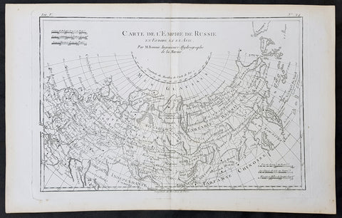
1780 Rigobert Bonne Original Antique Map of The Russian Empire
- Title : Carte De L Empire de Russie en Europe et en Asie...M Bonne
- Size: 15in x 10in (380mm x 255mm)
- Ref #: 31674
- Date : 1780
- Condition: (A+) Fine Condition
Description:
This original copper-plate engraved map was published in 1780 edition of Atllas des toutes les parties connues du globe terrestre by Rigobert Bonne & Guillaume Raynal.
General Definitions:
Paper thickness and quality: - Heavy and stable
Paper color : - off white
Age of map color: -
Colors used: -
General color appearance: -
Paper size: - 15in x 10in (380mm x 255mm)
Plate size: - 13in x 9in (330mm x 230mm)
Margins: - Min 1in (25mm)
Imperfections:
Margins: - None
Plate area: - None
Verso: - None
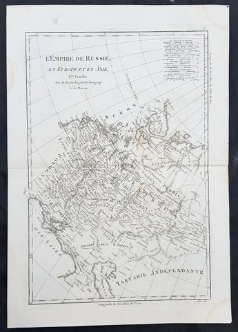
1780 Rigobert Bonne Original Antique Map of Western, European Russia, Poland
- Title : L Empire de Russie en Europe et an Asie...M Bonne
- Size: 15in x 10in (380mm x 255mm)
- Ref #: 40527
- Date : 1780
- Condition: (A+) Fine Condition
Description:
This original copper-plate engraved map was published in 1780 edition of Atllas des toutes les parties connues du globe terrestre by Rigobert Bonne & Guillaume Raynal.
General Definitions:
Paper thickness and quality: - Heavy and stable
Paper color : - off white
Age of map color: -
Colors used: -
General color appearance: -
Paper size: - 15in x 10in (380mm x 255mm)
Plate size: - 13in x 9in (330mm x 230mm)
Margins: - Min 1in (25mm)
Imperfections:
Margins: - None
Plate area: - None
Verso: - None
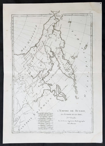
1780 Rigobert Bonne Original Antique Map of Eastern Russia, China
- Title : L Empire de Russie en Europe et an Asie...M Bonne
- Size: 15in x 10in (380mm x 255mm)
- Ref #: 40528
- Date : 1780
- Condition: (A+) Fine Condition
Description:
This original copper-plate engraved map was published in 1780 edition of Atllas des toutes les parties connues du globe terrestre by Rigobert Bonne & Guillaume Raynal.
General Definitions:
Paper thickness and quality: - Heavy and stable
Paper color : - off white
Age of map color: -
Colors used: -
General color appearance: -
Paper size: - 15in x 10in (380mm x 255mm)
Plate size: - 13in x 9in (330mm x 230mm)
Margins: - Min 1in (25mm)
Imperfections:
Margins: - None
Plate area: - None
Verso: - None
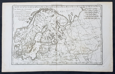
1780 Bonne Original Antique Map of Scandinavia, Baltic States & European Russia
- Title : Le Nord De L Europe contenant Le Danemark La Norwege, La Suede et la Laponie avec la Majeure Partie de la Russie Europeenne Par M Bonne
- Size: 16in x 11in (405mm x 2805mm)
- Ref #: 31671
- Date : 1780
- Condition: (A+) Fine Condition
Description:
This fine original copper-plate engraved antique map of Scandinavia, The Baltic States & European Russia was published in 1780 edition of Atlas des toutes les parties connues du globe terrestre by Rigobert Bonne & Guillaume Raynal.
General Definitions:
Paper thickness and quality: - Heavy and stable
Paper color : - off white
Age of map color: -
Colors used: -
General color appearance: -
Paper size: - 16in x 11in (405mm x 2805mm)
Plate size: - 14in x 10in (355mm x 255mm)
Margins: - Min 1/2in (12mm)
Imperfections:
Margins: - None
Plate area: - None
Verso: - None